Sharp Interface Approach for Regional and Well Scale Modeling of Small Island Freshwater Lens: Tongatapu Island


Abstract
1. Introduction
2. Materials and Methods
2.1. Study Area
2.2. Sharp Interface Freshwater-Seawater Groundwater Flow Numerical Model
2.2.1. Governing Equations
2.2.2. Conceptual Model for Groundwater Flow in Tongatapu Island
2.3. Calibration of the Model
2.4. Long-Term Stresses
2.4.1. Impact of the Current Pumping
2.4.2. Impact of Long-Term Stresses
3. Results
3.1. Results of Calibration
3.2. Current State of Freshwater Lens and Impact of Current Pumping
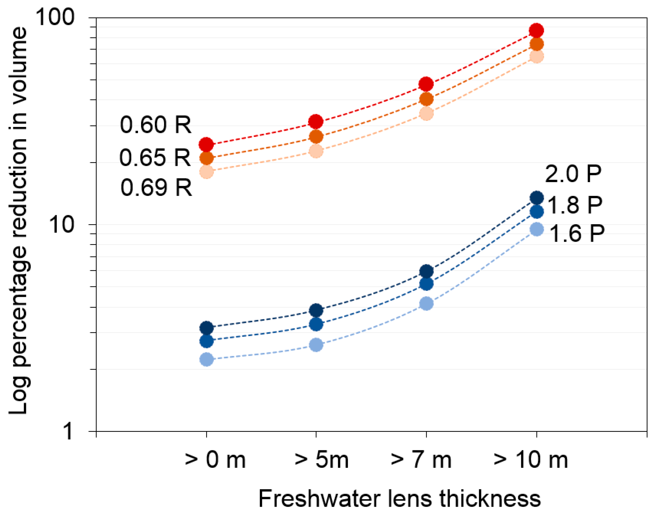
3.3. Predicted Effects of Long-Term Stresses
3.3.1. Impact on Freshwater Lens
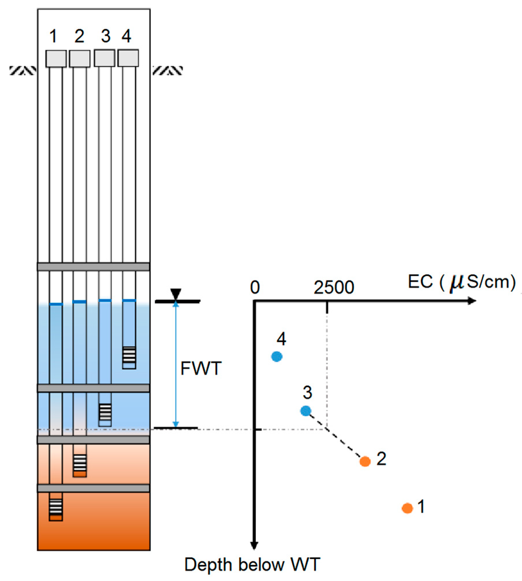
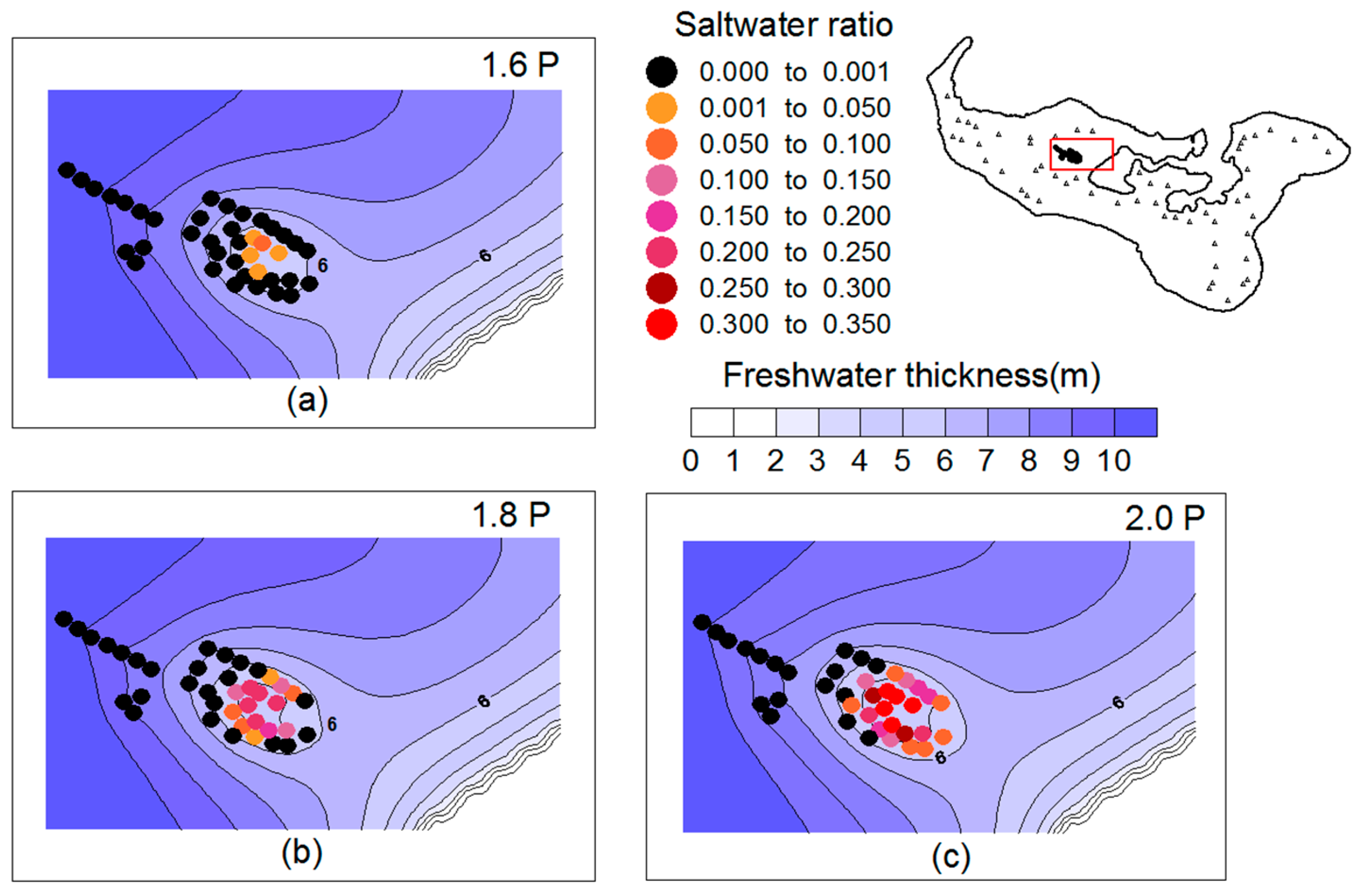
3.3.2. Well Salinization
4. Discussion
5. Conclusions
Supplementary Materials
Author Contributions
Funding
Acknowledgments
Conflicts of Interest
References
- Falkland, A.; Custodio, E.; Diaz Arenas, E.; Simler, E. Hydrology and Water Resources of Small Islands: A Practical Guide; UNESCO: Paris, France, 1991; pp. 24 & 208. ISBN 9231027530. [Google Scholar]
- White, I.; Falkland, T. Management of freshwater lenses on small Pacific islands. Hydrogeol. J. 2010, 18, 227–246. [Google Scholar] [CrossRef]
- Nurse, L.A.; Mclean, R.F.; Agard, J.; Briguglio, L.P.; Duvat-Magnan, V.; Pelesikoti, N.; Tompkins, E.; Webb, A. Small islands. In Climate Change 2014: Impacts, Adaptation, and Vulnerability. Part B: Regional Aspects. Contribution of Working Group II to the Fifth Assessment Report of the Intergovernmental Panel on Climate Change; Field, C.B., Barros, V.R., Dokken, D.J., Mastrandrea, M.D., Mach, K.J., Bilir, T.E., Chatterjee, M., Ebi, K.L., Estrada, Y.O., Genova, R.C., et al., Eds.; Cambridge University Press: Cambridge, UK, 2014; pp. 1613–1654. ISBN 9781107415386. [Google Scholar]
- Cai, W.; Borlace, S.; Lengaigne, M.; Van Rensch, P.; Collins, M.; Vecchi, G.; Timmermann, A.; Santoso, A.; McPhaden, M.J.; Wu, L. Increasing frequency of extreme El Niño events due to greenhouse warming. Nat. Clim. Chang. 2014, 4, 111–116. [Google Scholar] [CrossRef]
- Groundwater Monitoring in Small Island Developing States in the Pacific. International Groundwater Resource Assessment Centre (IGRAC), The Netherlands. Available online: http://ihp-hwrp.nl/wp-content/uploads/2016/11/Groundwater-Monitoring-in-Small-Island-Developing-States-in-the-Pacific.pdf (accessed on 30 September 2017).
- Werner, A.D.; Alcoe, D.W.; Ordens, C.M.; Hutson, J.L.; Ward, J.D.; Simmons, C.T. Current practice and future challenges in coastal aquifer management: Flux-based and trigger-level approaches with application to an Australian case study. Water Resour. Manag. 2011, 25, 1831–1853. [Google Scholar] [CrossRef]
- Werner, A.D.; Sharp, H.K.; Galvis, S.C.; Post, V.E.A.; Sinclair, P. Hydrogeology and management of freshwater lenses on atoll islands: Review of current knowledge and research needs. J. Hydrol. 2017, 551, 819–844. [Google Scholar] [CrossRef]
- Bailey, R.T.; Jenson, J.W.; Olsen, A.E. Numerical modeling of atoll island hydrogeology. Ground Water 2009, 47, 184–196. [Google Scholar] [CrossRef] [PubMed]
- Ketabchi, H.; Mahmoodzadeh, D.; Ataie-Ashtiani, B.; Simmons, C.T. Sea-level rise impacts on seawater intrusion in coastal aquifers: Review and integration. J. Hydrol. 2016, 535, 235–255. [Google Scholar] [CrossRef]
- Ataie-Ashtiani, B.; Rajabi, M.M.; Ketabchi, H. Inverse modelling for freshwater lens in small islands: Kish Island, Persian Gulf: Freshwater lens in small islands. Hydrol. Process. 2013, 27, 2759–2773. [Google Scholar] [CrossRef]
- Sulzbacher, H.; Wiederhold, H.; Siemon, B.; Grinat, M.; Igel, J.; Burschil, T.; Günther, T.; Hinsby, K. Numerical modelling of climate change impacts on freshwater lenses on the North Sea Island of Borkum using hydrological and geophysical methods. Hydrol. Earth Syst. Sci. 2012, 16, 3621–3643. [Google Scholar] [CrossRef]
- Post, V.E.; Bosserelle, A.L.; Galvis, S.C.; Sinclair, P.J.; Werner, A.D. On the resilience of small-island freshwater lenses: Evidence of the long-term impacts of groundwater abstraction on Bonriki Island, Kiribati. J. Hydrol. 2018, 564, 133–148. [Google Scholar] [CrossRef]
- Mahmoodzadeh, D.; Ketabchi, H.; Ataie-Ashtiani, B.; Simmons, C.T. Conceptualization of a fresh groundwater lens influenced by climate change: A modeling study of an arid-region island in the Persian Gulf, Iran. J. Hydrol. 2014, 519, 399–413. [Google Scholar] [CrossRef]
- Ghassemi, F.; Alam, K.; Howard, K. Fresh-water lenses and practical limitations of their three-dimensional simulation. Hydrogeol. J. 2000, 8, 521–537. [Google Scholar] [CrossRef]
- Sanford, W.E.; Pope, J.P. Current challenges using models to forecast seawater intrusion: Lessons from the Eastern Shore of Virginia, USA. Hydrogeol. J. 2010, 18, 73–93. [Google Scholar] [CrossRef]
- Bailey, R.T.; Jenson, J.W.; Taborosi, D. Estimating the freshwater-lens thickness of atoll islands in the Federated States of Micronesia. Hydrogeol. J. 2013, 21, 441–457. [Google Scholar] [CrossRef]
- Dausman, A.M.; Langevin, C.; Bakker, M.; Schaars, F. A Comparison between SWI and SEAWAT–the Importance of Dispersion, Inversion and Vertical Anisotropy. In Proceedings of the 21st Saltwater Intrusion Meeting (SWIM21), Azores, Portugal, 21–26 June 2010; de Melo, M.T.C., Lebbe, L., Cruz, J.V., Coutinho, R., Langevin, C., Buxo, A., Eds.; pp. 271–274. [Google Scholar]
- Shi, L.; Cui, L.; Park, N.; Huyakorn, P.S. Applicability of a sharp-interface model for estimating steady-state salinity at pumping wells—Validation against sand tank experiments. J. Contam. Hydrol. 2011, 124, 35–42. [Google Scholar] [CrossRef] [PubMed]
- Mehdizadeh, S.S.; Vafaie, F.; Abolghasemi, H. Assessment of sharp-interface approach for saltwater intrusion prediction in an unconfined coastal aquifer exposed to pumping. Environ. Earth Sci. 2015, 73, 8345–8355. [Google Scholar] [CrossRef]
- Person, M.; Taylor, J.Z.; Dingman, S.L. Sharp interface models of salt water intrusion and wellhead delineation on Nantucket Island, Massachusetts. Groundwater 1998, 36, 731–742. [Google Scholar] [CrossRef]
- Anderson, M.P.; Woessner, W.W.; Hunt, R.J. Applied Groundwater Modeling: Simulation of Flow and Advective Transport, 2nd ed.; Academic Press: Cambridge, MA, USA, 2015; pp. 380–385. ISBN 9780120581030. [Google Scholar]
- White, I.; Falkland, A.; Fatai, T. Vulnerability of Groundwater in Tongatapu, Kingdom of Tonga: Groundwater Evaluation and Monitoring Assessment, SOPAC/EU Reducing the Vulnerability of Pacific APC States; Australian National University: Canberra, Australia, 2009. [Google Scholar]
- Ghyben, B.W. Nota in verband met de voorgenomen putboring nabij, Amsterdam. Hague 1888, 21, 8–22. [Google Scholar]
- Herzberg, A. Die wasserversorgung einiger Nordseebader. J. Gasbeleucht. Wasserversorg. 1901, 44, 824–844. [Google Scholar]
- Huyakorn, P.S.; Wu, Y.S.; Park, N.S. Multiphase approach to the numerical solution of a sharp interface saltwater intrusion problem. Water Resour. Res. 1996, 32, 93–102. [Google Scholar] [CrossRef]
- Bear, J.; Cheng, A.H.-D.; Sorek, S.; Ouazar, D.; Herrera, I. Seawater Intrusion in Coastal Aquifers: Concepts, Methods and Practices; Kluwer Academic Publisher: Dordrecht, The Netherlands, 1999; Volume 14, pp. 213–247. ISBN 0792355733. [Google Scholar]
- Shi, L.; Cui, L.; Lee, C.J.; Hong, S.H.; Park, N.S. Applicability of a sharp-interface model in simulating saltwater contents of a pumping well in coastal areas. J. Eng. Geol. 2009, 19, 9–14. [Google Scholar]
- White, I.; Falkland, A.; Fatai, T. Vulnerability of Groundwater Resources in Tongatapu. In Proceedings of the 34th World Congress of the International Association for Hydro-Environment Research and Engineering: 33rd Hydrology and Water Resources Symposium and 10th Conference on Hydraulics in Water Engineering, Brisbane, Australia, 26 June–1 July 2011; pp. 879–887. [Google Scholar]
- Nath, D. Tonga Water Supply System Description Nuku’alofa/Lomaiviti; SPC Tech. Rep. No. 421; Secretariat of the Pacific Community: New Caledonia, France, 2010. [Google Scholar]
- Hunt, B. An analysis of the groundwater resources of Tongatapu Island, Kingdom of Tonga. J. Hydrol. 1979, 40, 185–196. [Google Scholar] [CrossRef]
- Bobba, A.G.; Singh, V.P. Prediction of Freshwater Depth due to Climate Change in Islands: Agati Island and Tongatapu Island. In Proceedings of the International Conference on Water, Environment, Ecology, Socio-Economics and Health Engineering (WEESHE), Seoul National University, Seoul, Korea, 18–21 October 1999; Singh, V.P., Seo, I.W., Sonu, J.H., Eds.; pp. 235–250. [Google Scholar]
- The Kingdom of Tonga. Tonga 2011 Census of Population and Housing, Volume 2: Analytical Report; Tonga Department of Statistics, Tonga and the Secretariat of the Pacific Community: New Caledonia, France, 2011.
- Furness, L.J.; Gingerich, S. Estimation of recharge to the fresh-water lens of Tongatapu, Kingdom of Tonga. IAHS Publ. 1993, 317–322. [Google Scholar]
- Hyland, K. Expansion of the Salinity Monitoring Network across Tongatapu; Ministry of Lands and Natural Resources: Nuku’alofa, Tonga, 2012.
- Furness, L.J.; Helu, S.P. The Hydrogeology and Water Supply of The Kingdom of Tonga; Ministry of Lands and Natural Resources: Nuku’alofa, Tonga, 1993.
- Van der Velde, M. Agricultural and Climatic Impacts on the Groundwater Resources of a Small Island: Measuring and Modeling Water and Solute Transport in Soil and Groundwater on Tongatapu. Ph.D. Thesis, UCL-Université Catholique de Louvain, Louvain, Belgium, May 2006. [Google Scholar]
- Climate Risk Management for the Water Sector in Tonga. Available online: http://www.pireport.org/ pireport/2015/July/Tonga_Paper_revised.pdf (accessed on 30 July 2016).
- Pacific Climate Change Science Program Report. Current and Future Climate of Tonga; Australian Government: Canberra, Australia, 2014.
- Waterloo, M.J.; Ijzermans, S. Groundwater Availability in Relation to Water Demands in Tongatapu; Dutch Risk Reduction DRR-Team Mission Report: Amsterdam, The Netherlands, 2017. [Google Scholar]
- Presley, T.K. Effects of the 1998 Drought on the Freshwater Lens in the Laura Area, Majuro Atoll, Republic of the Marshall Islands, Sci. Invest. Rep. 2005-5098; US Geological Survey: Reston, VA, USA, 2005.
- Bear, J. Hydraulics of Groundwater, 1st ed.; McGraw-Hill: New York, NY, USA, 1979; pp. 381–384. ISBN 978-0-486-45355-2. [Google Scholar]
- Park, N.S.; Lee, Y.D. Seawater intrusion due to groundwater developments in eastern and central Cheju watersheds. J. Korean Soc. Groundw. Environ. 1997, 4, 5–13. [Google Scholar]
- Hong, S.H.; Han, S.Y.; Park, N.S. Assessment of potential groundwater development in coastal area. J. Korean Soc. Civ. Eng. 2003, 23, 201–207. [Google Scholar]
- Han, S.Y.; Hong, S.H.; Park, N.S. Assessment of coastal groundwater discharge for complex coastlines. J. Korea Water Resour. Assoc. 2004, 37, 939–947. [Google Scholar] [CrossRef]
- Park, N.; Koh, B.R.; Lim, Y. Impacts of fresh and saline groundwater development in Sungsan watershed, Jeju Island. J. Korea Water Resour. Assoc. 2013, 46, 783–794. [Google Scholar] [CrossRef]
- Hong, S.H.; Shi, L.; Cui, L.; Park, N. Artificial injection to control saltwater intrusion in groundwater-numerical study on a vertical cross section. Eng. Geol. J. 2009, 19, 131–138. [Google Scholar]
- Jung, E.T.; Lee, S.J.; Lee, M.J.; Park, N. Effectiveness of double negative barriers for mitigation of seawater intrusion in coastal aquifer: Sharp-interface modeling investigation. J. Korea Water Resour. Assoc. 2014, 47, 1087–1094. [Google Scholar] [CrossRef]
- PACC Technical Report. Design for Improved Water Supply and Water Management in Hihifo District, Tonga, No. 7; Secretariat of the Pacific Regional Environment Programme: Apia, Samoa, 2014. [Google Scholar]
- van der Velde, M.; Javaux, M.; Vanclooster, M.; Clothier, B.E. El Niño-Southern Oscillation determines the salinity of the freshwater lens under a coral atoll in the Pacific Ocean. Geophys. Res. Lett. 2006, 33, L21403. [Google Scholar] [CrossRef]
- Sefelnasr, A.; Sherif, M. Impacts of seawater rise on seawater intrusion in the Nile Delta aquifer, Egypt. Groundwater 2014, 52, 264–276. [Google Scholar] [CrossRef] [PubMed]
- Jakovovic, D.; Werner, A.D.; de Louw, P.G.; Post, V.E.; Morgan, L.K. Saltwater upconing zone of influence. Adv. Water Resour. 2016, 94, 75–86. [Google Scholar] [CrossRef]


| Sl.No | Scenario | Recharge (m/year) | Pumping from Public Wells (m3/day) |
|---|---|---|---|
| 1 | Base (current) | 0.570 (R) | 10,410 (P) |
| 2 | 0.69 R | 0.393 | 10,410 |
| 3 | 0.65 R | 0.371 | 10,410 |
| 4 | 0.60 R | 0.342 | 10,410 |
| 5 | 1.6 P | 0.570 | 16,656 |
| 6 | 1.8 P | 0.570 | 18,738 |
| 7 | 2.0 P | 0.570 | 20,820 |
| Parameters | Values |
|---|---|
| Number of observation points | 16 |
| Correlation coefficient | 0.87 |
| Range in observations | 8.23 m |
| Maximum residual | 2.65 m |
| Minimum residual | −2.84 m |
| Residual mean | 0.27 m |
| Absolute residual mean | 1.15 m |
| Root mean squared error | 1.44 m |
| Normalized RMS error | 13.8% |
| Scaled RMS error | 17.5% |
| Parameters | Current Pumping | Predevelopment | Percentage Decrease | |
|---|---|---|---|---|
| Maximum freshwater head (m) | 0.329 | 0.347 | 5.19 | |
| Minimum interface elevation(m) | −13.72 | −14.46 | 5.12 | |
| Freshwater thickness (m) | Maximum | 14.05 | 14.81 | 5.13 |
| Average | 8.40 | 9.02 | 6.87 | |
| Area (km2) where lens thickness is | >5 m | 206.5 | 208.2 | 0.79 |
| >7 m | 167.3 | 170.8 | 2.08 | |
| >10 m | 83.1 | 91.7 | 9.39 | |
| Volume (MCM) of freshwater where lens thickness is | >0 m | 636.7 | 658.4 | 3.30 |
| >5 m | 581.4 | 604.7 | 3.86 | |
| >7 m | 510.1 | 536.9 | 5.00 | |
| >10 m | 294.8 | 334.6 | 11.90 | |
| Sl.No | Scenario | Percentage of Wells Intruded by Saltwater | Maximum Saltwater Ratio |
|---|---|---|---|
| 1 | Base (current) | 0.0 | 0.00 |
| 2 | 0.69 R | 5.1 | 0.004 |
| 3 | 0.65 R | 38.5 | 0.13 |
| 4 | 0.60 R | 51.3 | 0.22 |
| 5 | 1.6 P | 12.8 | 0.05 |
| 6 | 1.8 P | 38.5 | 0.24 |
| 7 | 2.0 P | 53.8 | 0.35 |
© 2018 by the authors. Licensee MDPI, Basel, Switzerland. This article is an open access article distributed under the terms and conditions of the Creative Commons Attribution (CC BY) license (http://creativecommons.org/licenses/by/4.0/).
Share and Cite
Babu, R.; Park, N.; Yoon, S.; Kula, T. Sharp Interface Approach for Regional and Well Scale Modeling of Small Island Freshwater Lens: Tongatapu Island. Water 2018, 10, 1636. https://doi.org/10.3390/w10111636
Babu R, Park N, Yoon S, Kula T. Sharp Interface Approach for Regional and Well Scale Modeling of Small Island Freshwater Lens: Tongatapu Island. Water. 2018; 10(11):1636. https://doi.org/10.3390/w10111636
Chicago/Turabian StyleBabu, Roshina, Namsik Park, Sunkwon Yoon, and Taaniela Kula. 2018. "Sharp Interface Approach for Regional and Well Scale Modeling of Small Island Freshwater Lens: Tongatapu Island" Water 10, no. 11: 1636. https://doi.org/10.3390/w10111636
APA StyleBabu, R., Park, N., Yoon, S., & Kula, T. (2018). Sharp Interface Approach for Regional and Well Scale Modeling of Small Island Freshwater Lens: Tongatapu Island. Water, 10(11), 1636. https://doi.org/10.3390/w10111636