Groundwater Augmentation through the Site Selection of Floodwater Spreading Using a Data Mining Approach (Case study: Mashhad Plain, Iran)

 , ,
, ,  and
and
Abstract
:1. Introduction
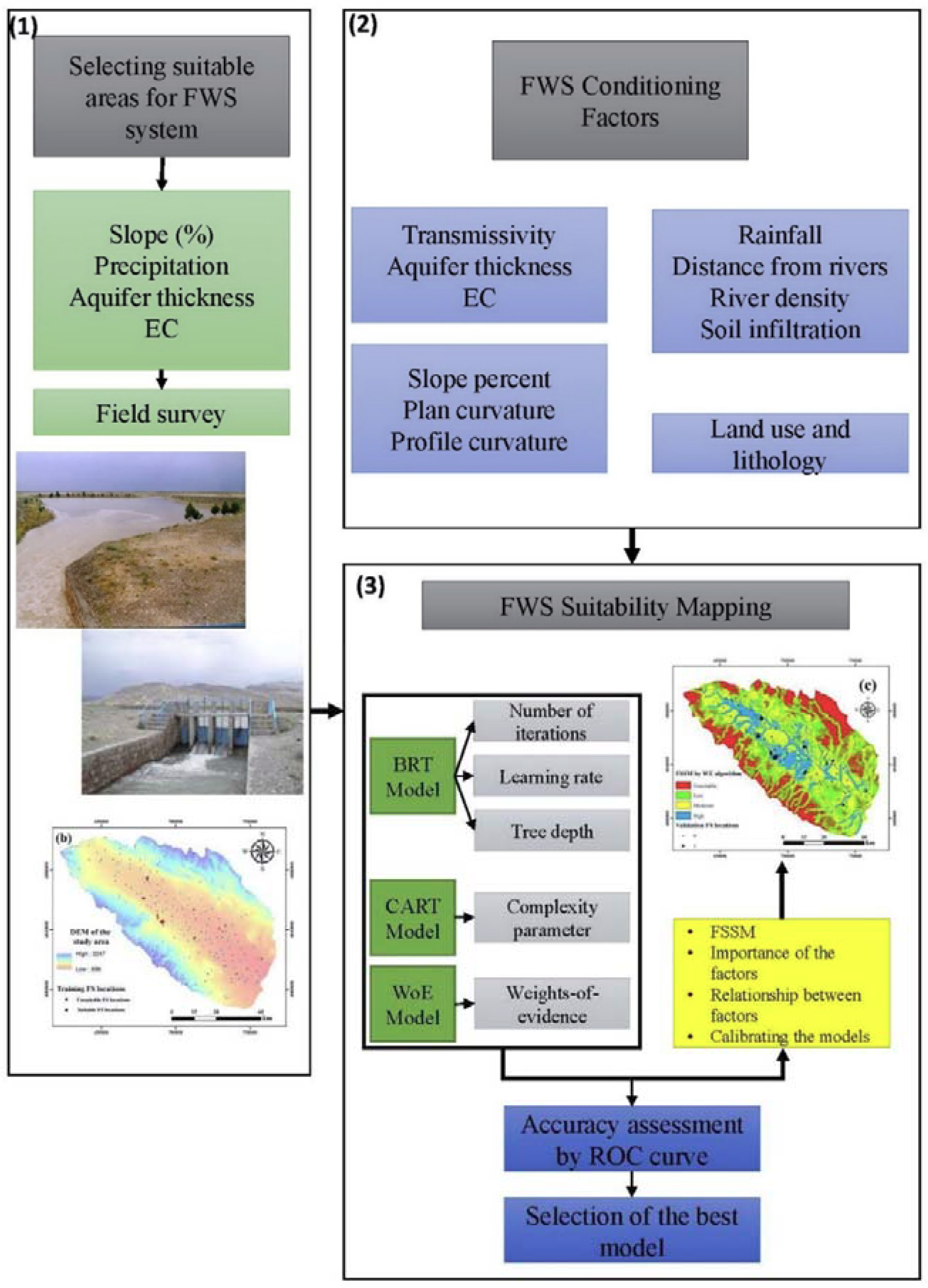
2. Materials and Methods
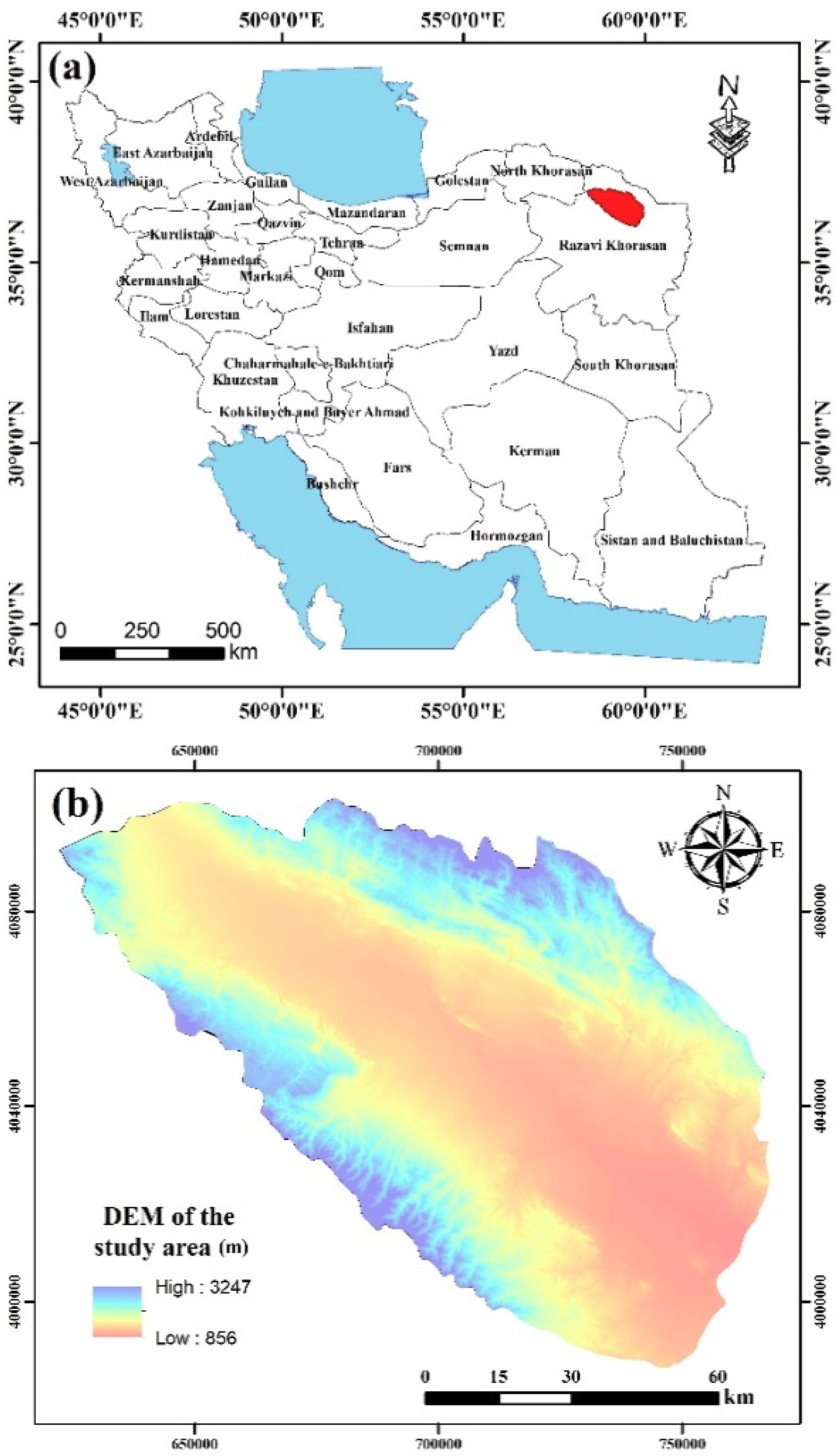
2.1. Study Area
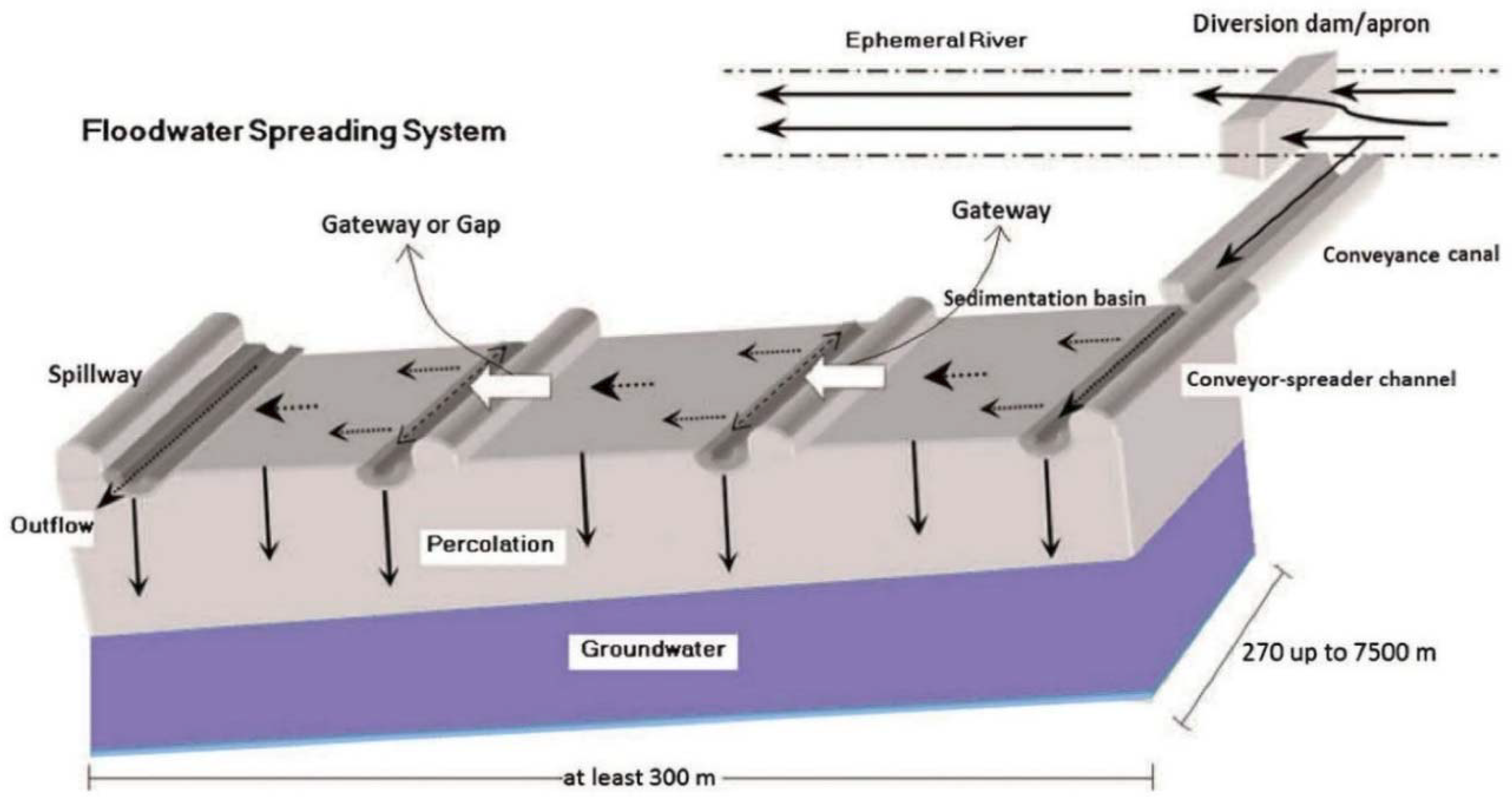
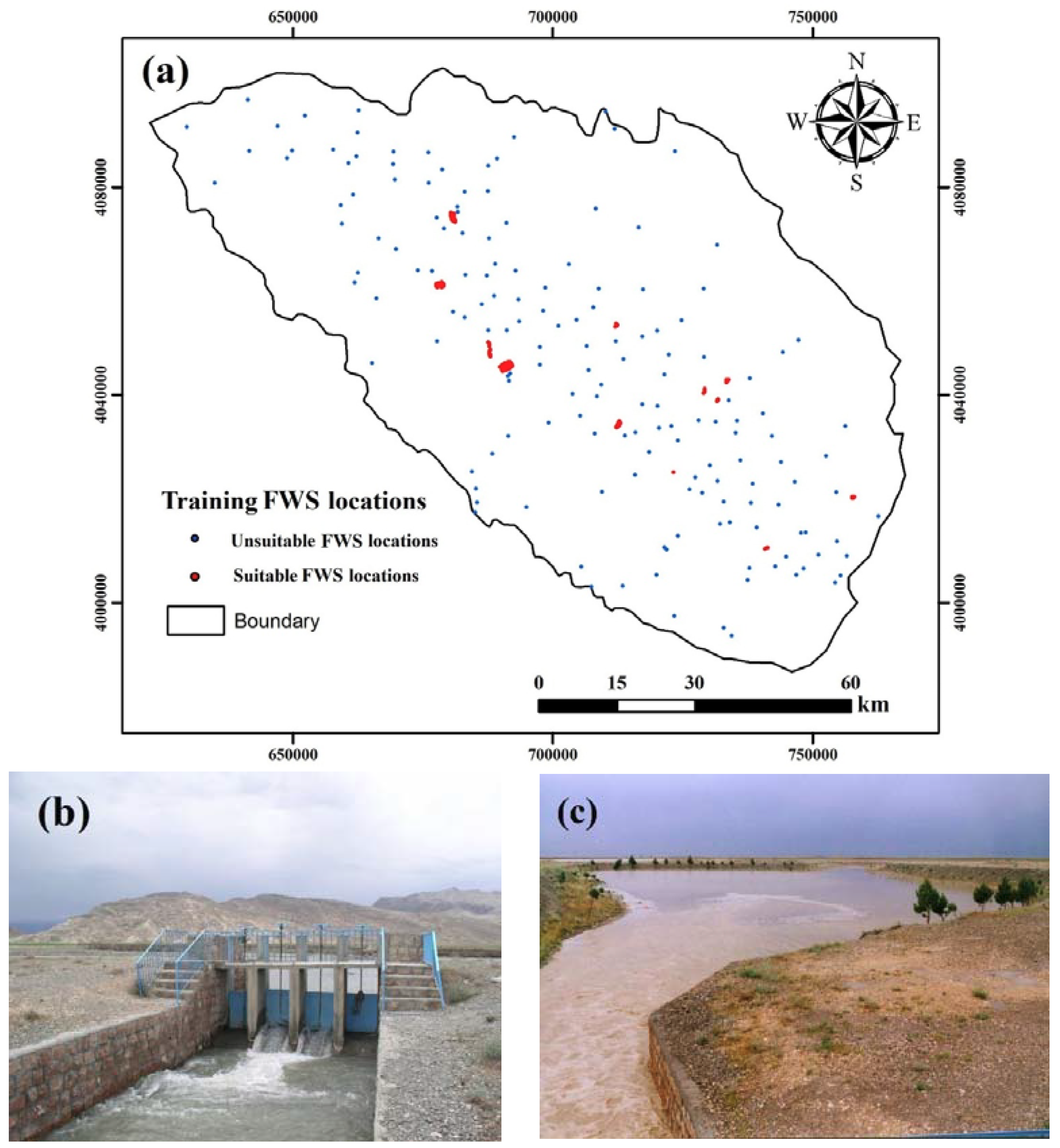
2.2. Floodwater Spreading Dataset
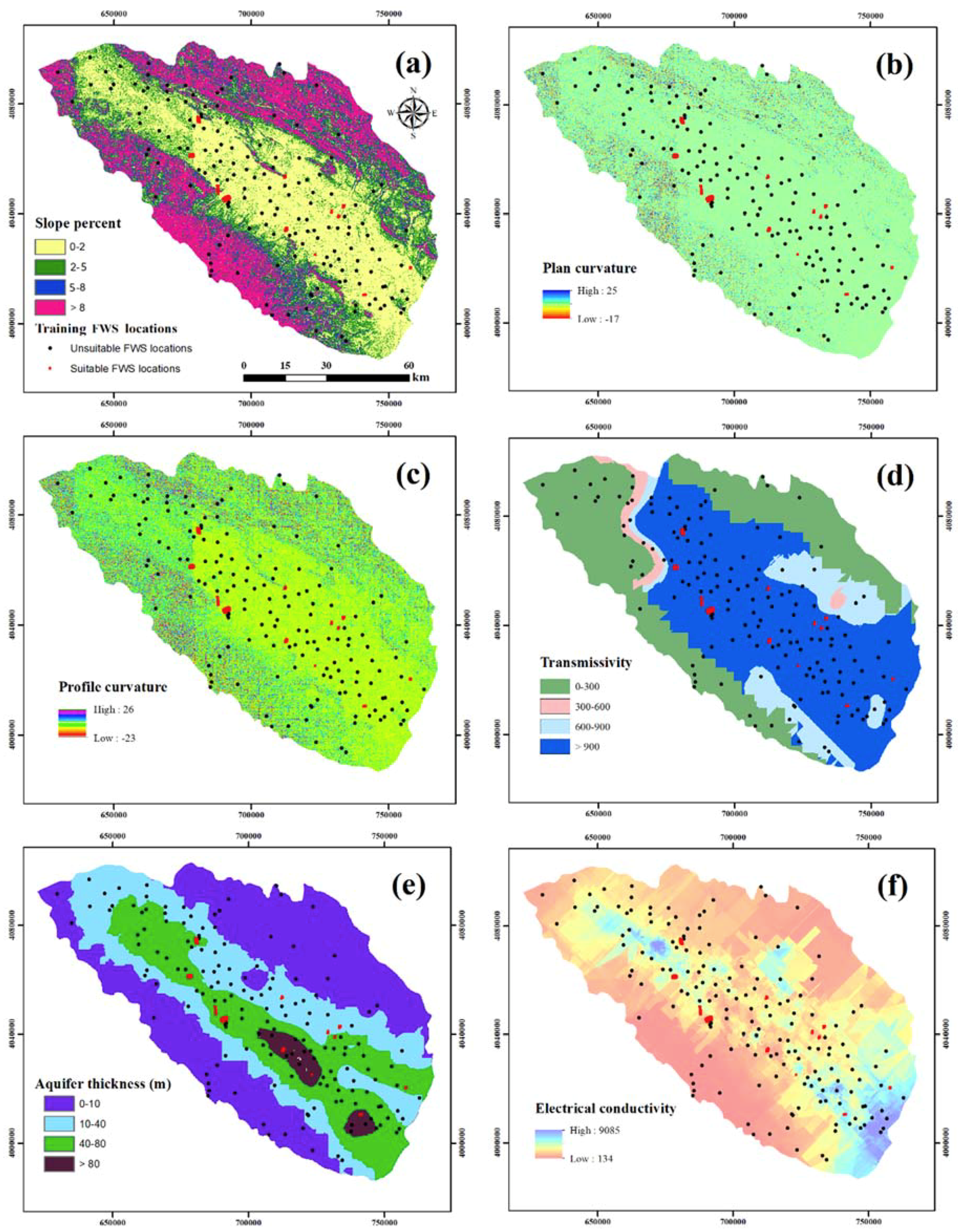
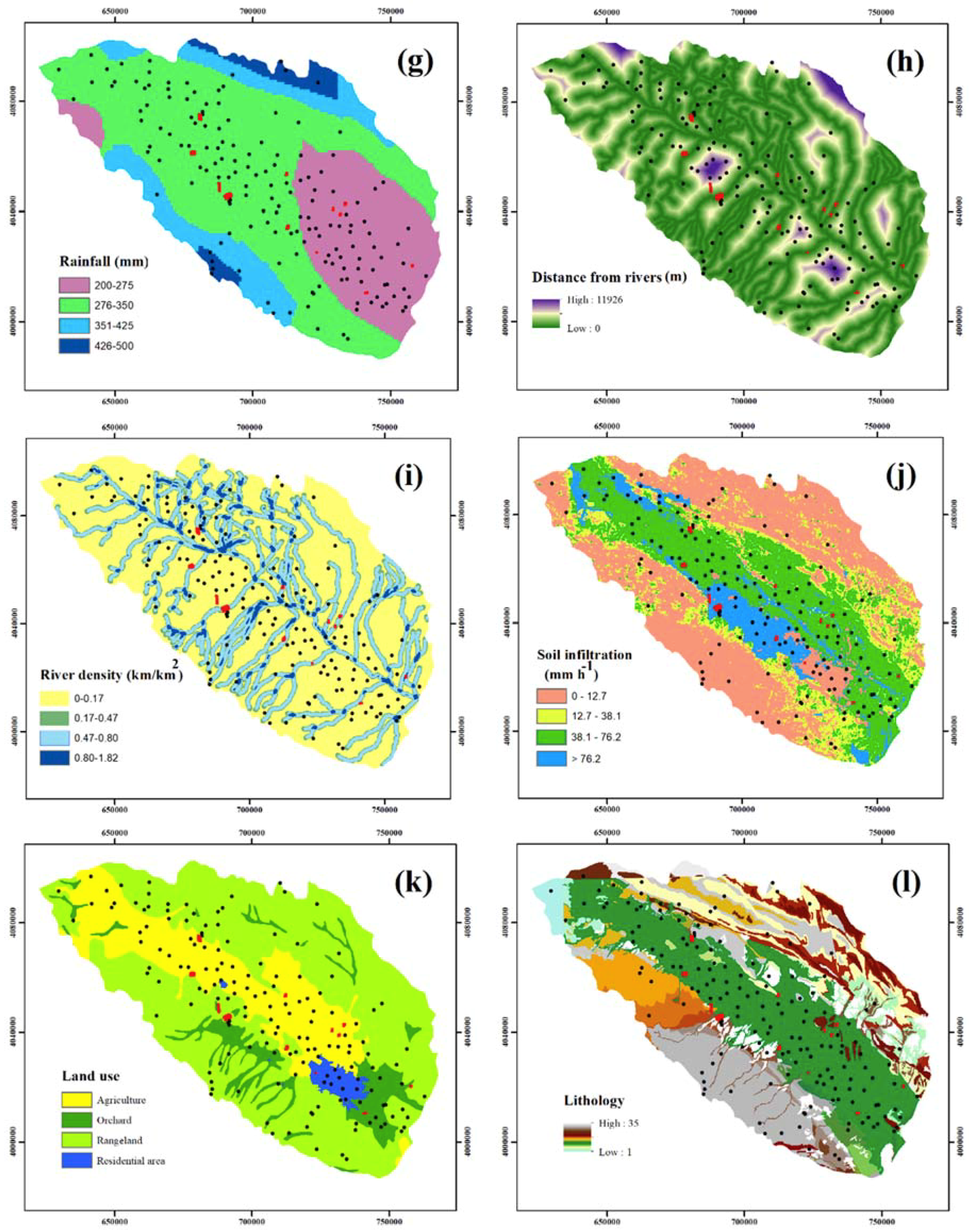
2.3. Floodwater Spreading Conditioning Factors
2.4. Modeling Approaches
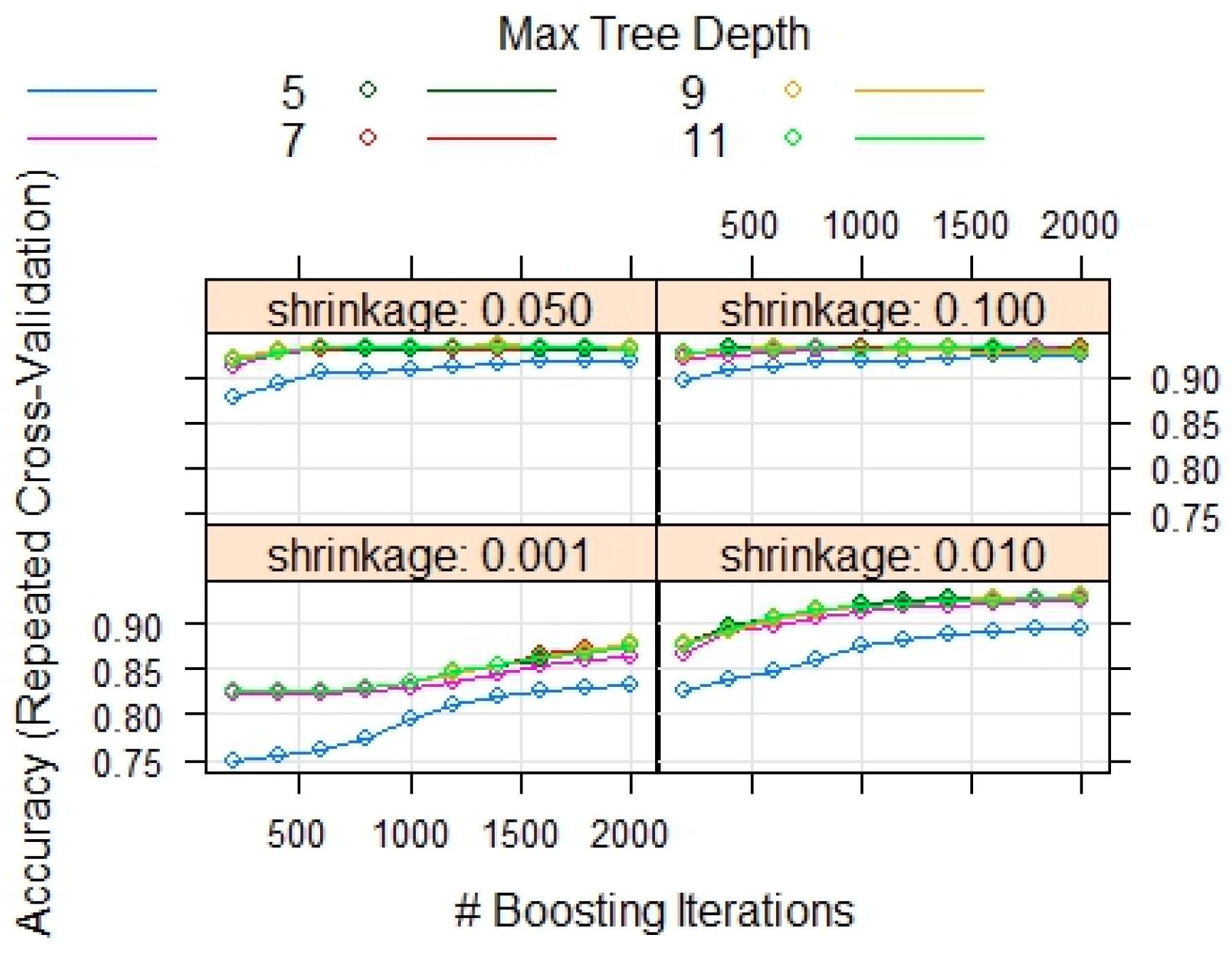
2.4.1. FWS Suitability Modeling by BRT
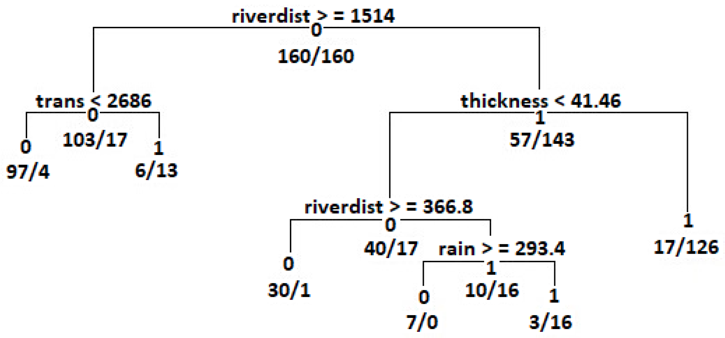
2.4.2. FWS Suitability Modeling by CART
2.4.3. FWS Suitability Modeling by WoE
3. Results
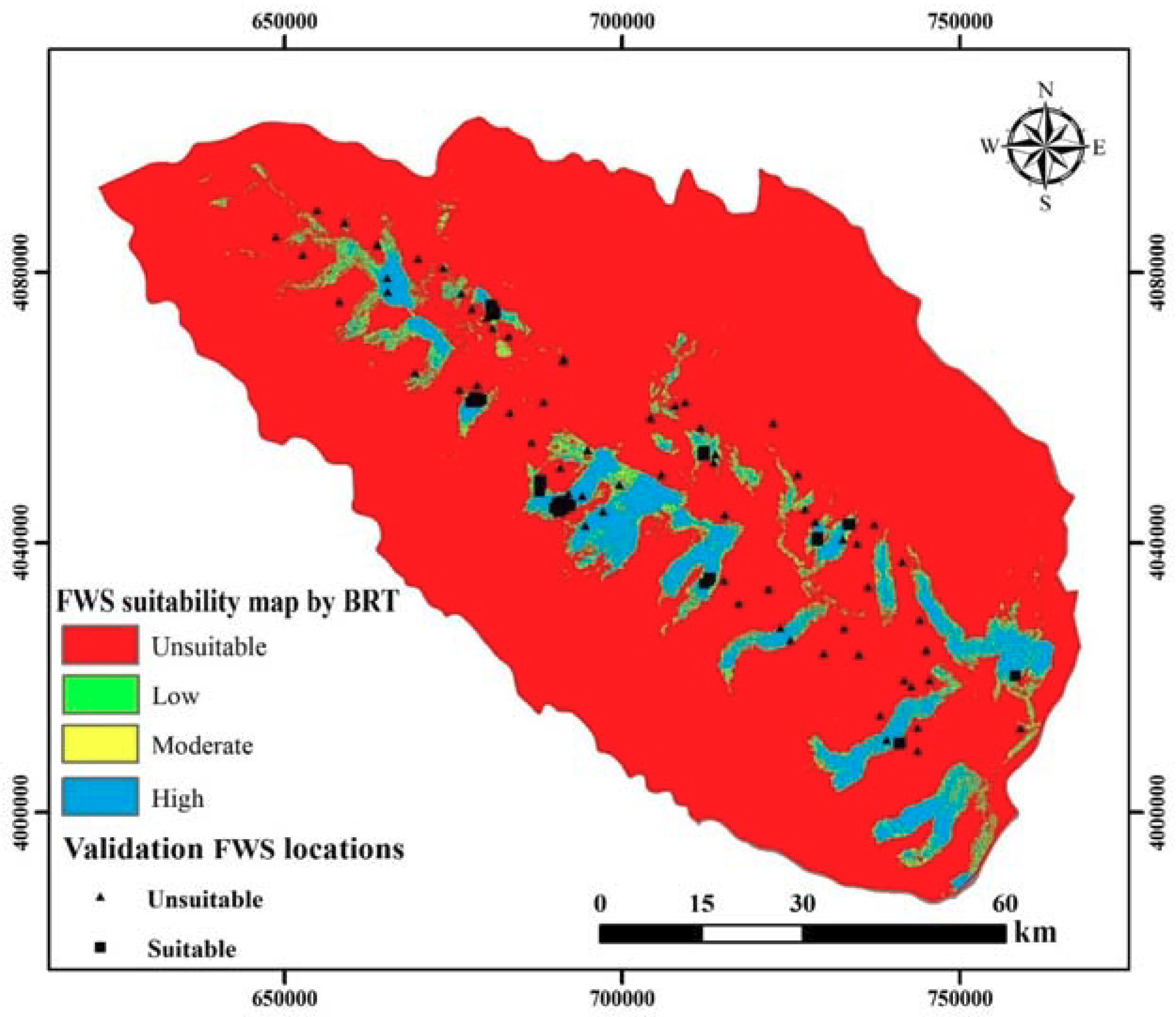
3.1. Application of BRT
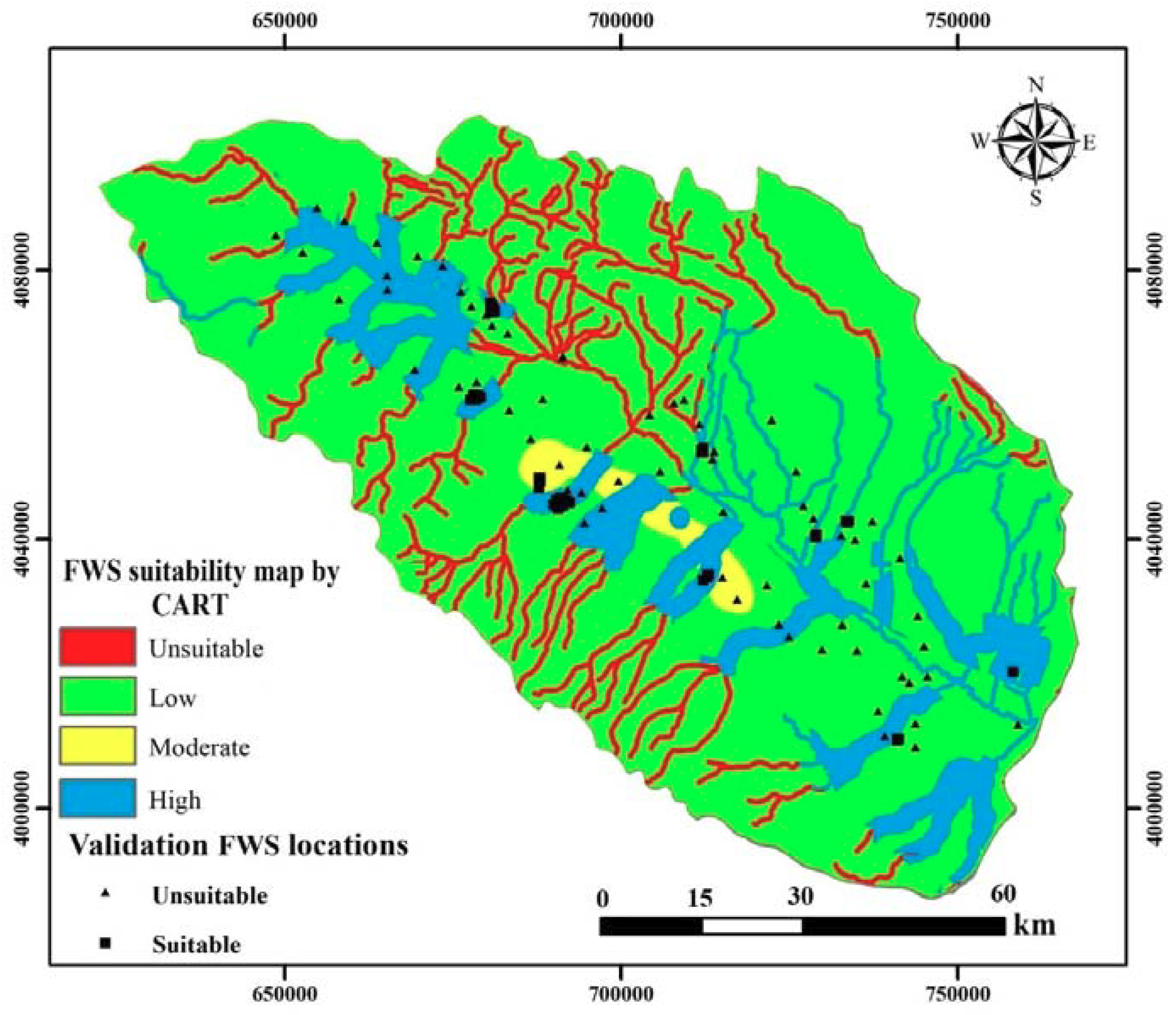
3.2. Application of CART
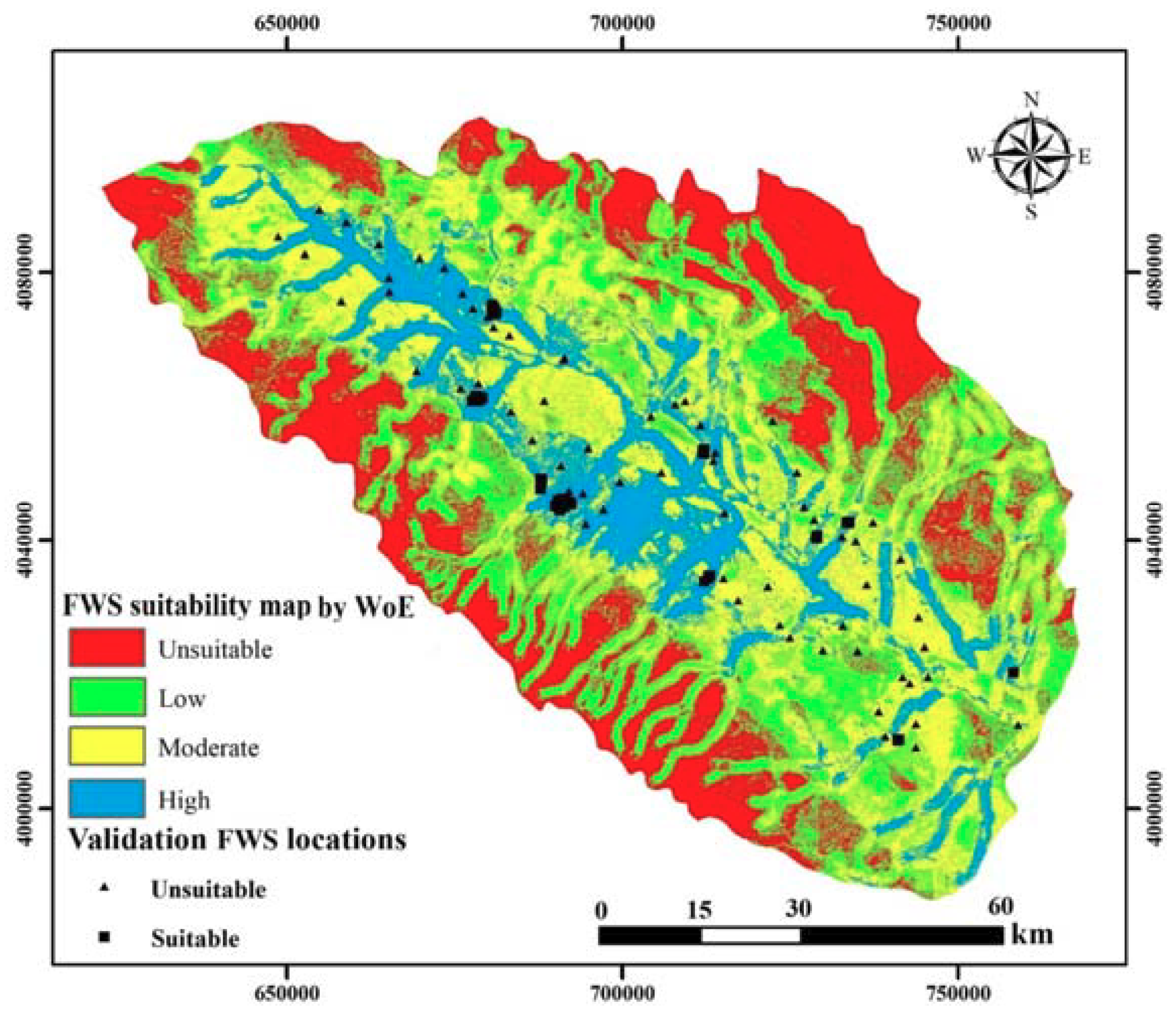
3.3. Application of WoE
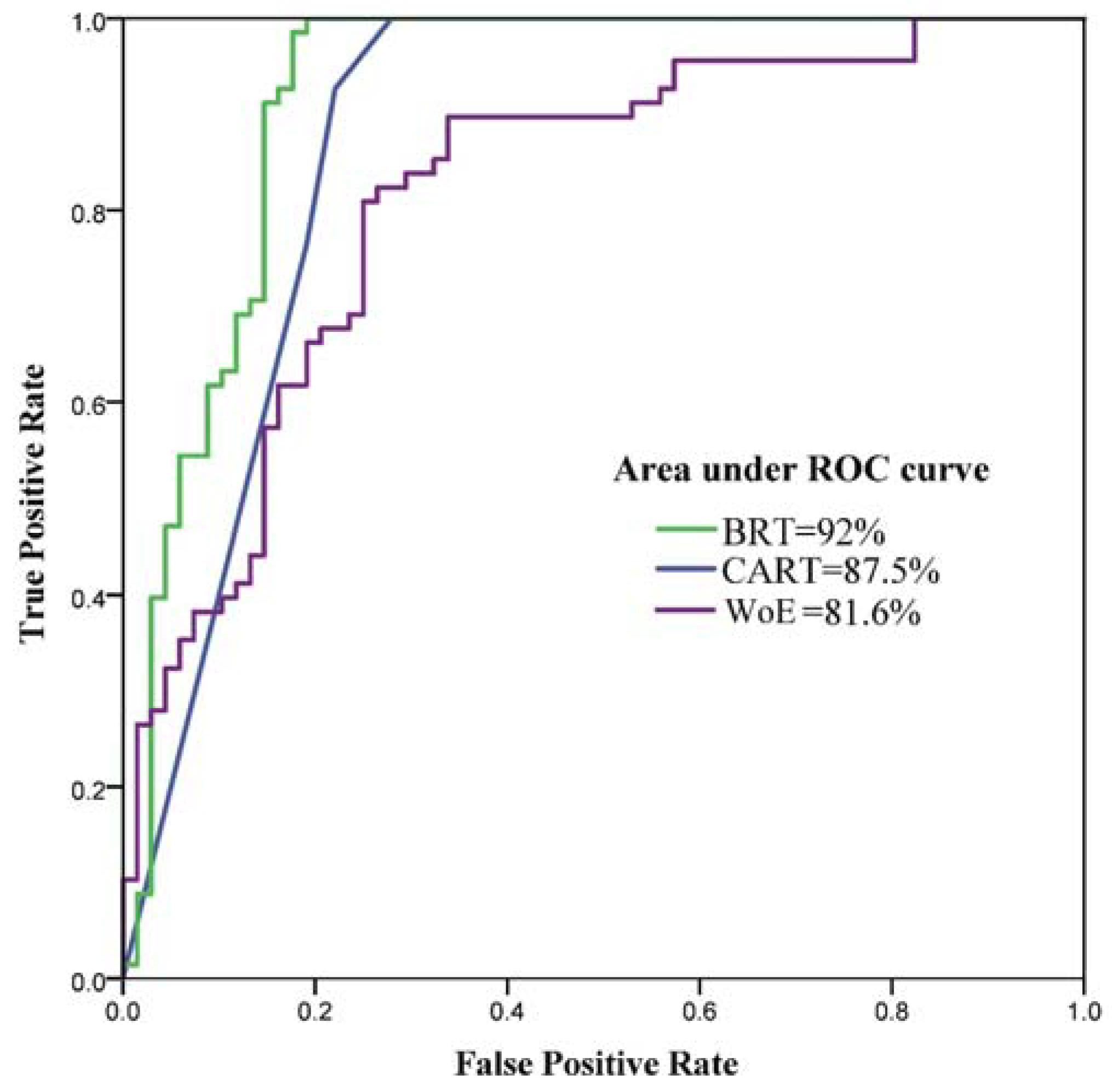
3.4. Validation of the FWS Suitability Maps by a ROC Curve
4. Discussion
Author Contributions
Acknowledgments
Conflicts of Interest
References
- Mahdavi, M. Applied Hydrology, 5th ed.; University of Tehran Press: Tehran, Iran, 2004; Volume 2. [Google Scholar]
- Chezgi, J.; Pourghasemi, H.R.; Naghibi, S.A.; Moradi, H.R.; Kheirkhah Zarkesh, M. Assessment of a spatial multi-criteria evaluation to site selection underground dams in the Alborz Province, Iran. Geocarto Int. 2015, 31, 628–646. [Google Scholar] [CrossRef]
- Shaker, M.; Hosseini, H. Aid and save learning and reduction of disaster impacts. In Proceedings of the International Conference of Crisis Management, Tehran, Iran, 24 September 2006. [Google Scholar]
- Pradhan, B.; Youssef, A.M. A 100-year maximum flood susceptibility mapping using integrated hydrological and hydrodynamic models: Kelantan River Corridor, Malaysia. J. Flood Risk Manag. 2011, 4, 189–202. [Google Scholar] [CrossRef]
- Rahmati, O.; Pourghasemi, H.R.; Melesse, A.M. Application of GIS-based data driven random forest and maximum entropy models for groundwater potential mapping: A case study at Mehran Region, Iran. Catena 2016, 137, 360–372. [Google Scholar] [CrossRef]
- Hashemi, H.; Berndtsson, R.; Kompani-Zare, M.; Persson, M. Natural vs. artificial groundwater recharge, quantification through inverse modeling. Hydrol. Earth Syst. Sci. 2013, 17, 637–650. [Google Scholar] [CrossRef]
- Jafari, M.; Tavili, A.; Panahi, F.; Zandi Esfahan, E.; Ghorbani, M. Reclamation of Arid Lands; Springer International Publishing: Basel, Switzerland, 2018; ISBN 978-3-319-54827-2. [Google Scholar]
- Zarkesh, M.K. Decision Support System for Floodwater Spreading Site Selection in Iran; ITC Publication: Cannon Hill, Australia, 2005; ISBN 9085042569. [Google Scholar]
- Ghayoumian, J.; Ghermezcheshme, B.; Feiznia, S.; Noroozi, A.A. Integrating GIS and DSS for identification of suitable areas for artificial recharge, case study Meimeh Basin, Isfahan, Iran. Environ. Geol. 2005, 47, 493–500. [Google Scholar] [CrossRef]
- Ghayoumian, J.; Mohseni Saravi, M.; Feiznia, S.; Nouri, B.; Malekian, A. Application of GIS techniques to determine areas most suitable for artificial groundwater recharge in a coastal aquifer in southern Iran. J. Asian Earth Sci. 2007, 30, 364–374. [Google Scholar] [CrossRef]
- Alesheikh, A.A.; Soltani, M.J.; Nouri, N.; Khalilzadeh, M. Land assessment for flood spreading site selection using geospatial information system. Int. J. Environ. Sci. Technol. 2008, 5, 455–462. [Google Scholar] [CrossRef] [Green Version]
- Mahdavi, A.; Tabatabaei, S.H.; Mahdavi, R.; Nouri Emamzadei, M.R. Application of digital techniques to identify aquifer artificial recharge sites in GIS environment. Int. J. Digit. Earth 2013, 6, 589–609. [Google Scholar] [CrossRef] [Green Version]
- Moradi Dashtpagerdi, M.; Nohegar, A.; Vagharfard, H.; Honarbakhsh, A.; Mahmoodinejad, V.; Noroozi, A.; Ghonchehpoor, D. Application of Spatial Analysis Techniques to Select the Most Suitable Areas for Flood Spreading. Water Resour. Manag. 2013, 27, 3071–3084. [Google Scholar] [CrossRef]
- Zaidi, F.K.; Nazzal, Y.; Ahmed, I.; Naeem, M.; Jafri, M.K. Identification of potential artificial groundwater recharge zones in Northwestern Saudi Arabia using GIS and Boolean logic. J. Afr. Earth Sci. 2015, 111, 156–169. [Google Scholar] [CrossRef]
- Sargaonkar, A.P.; Rathi, B.; Baile, A. Identifying potential sites for artificial groundwater recharge in sub-watershed of River Kanhan, India. Environ. Earth Sci. 2011, 62, 1099–1108. [Google Scholar] [CrossRef]
- Nasiri, H.; Boloorani, A.D.; Sabokbar, H.A.F.; Jafari, H.R.; Hamzeh, M.; Rafii, Y. Determining the most suitable areas for artificial groundwater recharge via an integrated PROMETHEE II-AHP method in GIS environment (case study: Garabaygan Basin, Iran). Environ. Monit. Assess. 2013, 185, 707–718. [Google Scholar] [CrossRef] [PubMed]
- Rahimi, S.; Shadman Roodposhti, M.; Ali Abbaspour, R. Using combined AHP-genetic algorithm in artificial groundwater recharge site selection of Gareh Bygone Plain, Iran. Environ. Earth Sci. 2014, 72, 1979–1992. [Google Scholar] [CrossRef]
- Agarwal, R.; Garg, P.K. Remote Sensing and GIS Based Groundwater Potential & Recharge Zones Mapping Using Multi-Criteria Decision-Making Technique. Water Resour. Manag. 2016, 30, 243–260. [Google Scholar] [CrossRef]
- Magesh, N.S.; Chandrasekar, N.; Soundranayagam, J.P. Delineation of groundwater potential zones in Theni district, Tamil Nadu, using remote sensing, GIS and MIF techniques. Geosci. Front. 2012, 3, 189–196. [Google Scholar] [CrossRef]
- Senanayake, I.P.; Dissanayake, D.M.D.O.K.; Mayadunna, B.B.; Weerasekera, W.L. An approach to delineate groundwater recharge potential sites in Ambalantota, Sri Lanka using GIS techniques. Geosci. Front. 2016, 7, 115–124. [Google Scholar] [CrossRef]
- Prabhu, M.V.; Venkateswaran, S. Delineation of Artificial Recharge Zones Using Geospatial Techniques in Sarabanga Sub Basin Cauvery River, Tamil Nadu. Aquat. Procedia 2015, 4, 1265–1274. [Google Scholar] [CrossRef]
- Carver, S.J. Integrating multi-criteria evaluation with geographical information systems. Int. J. Geogr. Inf. Syst. 1991, 5, 321–339. [Google Scholar] [CrossRef] [Green Version]
- Thungngern, J.; Wijitkosum, S.; Sriburi, T. A review of the analytical hierarchy process (AHP) an approach to water resource management in Thailand. Appl. Environ. Res. 2015, 37, 13–32. [Google Scholar]
- Naghibi, S.A.; Pourghasemi, H.R.; Dixon, B. GIS-based groundwater potential mapping using boosted regression tree, classification and regression tree, and random forest machine learning models in Iran. Environ. Monit. Assess. 2016, 188, 44. [Google Scholar] [CrossRef] [PubMed]
- Youssef, A.M.; Pourghasemi, H.R.; Pourtaghi, Z.S.; Al-Katheeri, M.M. Landslide susceptibility mapping using random forest, boosted regression tree, classification and regression tree, and general linear models and comparison of their performance at Wadi Tayyah Basin, Asir Region, Saudi Arabia. Landslides 2015. [Google Scholar] [CrossRef]
- Mousavi, S.M.; Golkarian, A.; Amir Naghibi, S.; Kalantar, B.; Pradhan, B. GIS-based Groundwater Spring Potential Mapping Using Data Mining Boosted Regression Tree and Probabilistic Frequency Ratio Models in Iran. AIMS Geosci. 2017, 3, 91–115. [Google Scholar] [CrossRef]
- Naghibi, S.A.; Pourghasemi, H.R. A Comparative Assessment Between Three Machine Learning Models and Their Performance Comparison by Bivariate and Multivariate Statistical Methods in Groundwater Potential Mapping. Water Resour. Manag. 2015, 29. [Google Scholar] [CrossRef]
- Tehrany, M.S.; Pradhan, B.; Jebur, M.N. Flood susceptibility mapping using a novel ensemble weights-of-evidence and support vector machine models in GIS. J. Hydrol. 2014, 512, 332–343. [Google Scholar] [CrossRef]
- Mohammady, M.; Pourghasemi, H.R.; Pradhan, B. Landslide susceptibility mapping at Golestan Province, Iran: A comparison between frequency ratio, Dempster–Shafer, and weights-of-evidence models. J. Asian Earth Sci. 2012, 61, 221–236. [Google Scholar] [CrossRef]
- Pourghasemi, H.R.; Pradhan, B.; Gokceoglu, C.; Mohammadi, M.; Moradi, H.R. Application of weights-of-evidence and certainty factor models and their comparison in landslide susceptibility mapping at Haraz watershed, Iran. Arab. J. Geosci. 2013, 6, 2351–2365. [Google Scholar] [CrossRef] [Green Version]
- Pourghasemi, H.; Pradhan, B.; Gokceoglu, C.; Moezzi, K.D. A comparative assessment of prediction capabilities of Dempster–Shafer and Weights-of-evidence models in landslide susceptibility mapping using GIS. Geomat. Nat. Hazards Risk 2013, 4, 93–118. [Google Scholar] [CrossRef] [Green Version]
- Hong, H.; Naghibi, S.A.; Pourghasemi, H.R.; Pradhan, B. GIS-based landslide spatial modeling in Ganzhou City, China. Arab. J. Geosci. 2016, 9, 112. [Google Scholar] [CrossRef]
- Regmi, A.D.; Devkota, K.C.; Yoshida, K.; Pradhan, B.; Pourghasemi, H.R.; Kumamoto, T.; Akgun, A. Application of frequency ratio, statistical index, and weights-of-evidence models and their comparison in landslide susceptibility mapping in Central Nepal Himalaya. Arab. J. Geosci. 2014, 7, 725–742. [Google Scholar] [CrossRef]
- Chen, W.; Xie, X.; Wang, J.; Pradhan, B.; Hong, H.; Bui, D.T.; Duan, Z.; Ma, J. A comparative study of logistic model tree, random forest, and classification and regression tree models for spatial prediction of landslide susceptibility. Catena 2017, 151, 147–160. [Google Scholar] [CrossRef]
- Abdullahi, S.; Pradhan, B. Sustainable Brownfields Land Use Change Modeling Using GIS-based Weights-of-Evidence Approach. Appl. Spat. Anal. Policy 2016, 9, 21–38. [Google Scholar] [CrossRef]
- Abdullahi, S.; Pradhan, B. Land use change modeling and the effect of compact city paradigms: Integration of GIS-based cellular automata and weights-of-evidence techniques. Environ. Earth Sci. 2018, 77, 251. [Google Scholar] [CrossRef]
- Khorasan Razavi Regional Water Authority (KRRWA) 2017. Available online: www.khrw.ir (accessed on 20 March 2018).
- Akbari, M.; Jorgeh, M.R.; Madani Sadat, H. Investigation of the water table decrease using geographic information system (GIS) (Case study: Mashhad Plan aquifer). Soil Water Conserv. J. 2009, 4, 63–78. (In Persian) [Google Scholar]
- Hashemi, H.; Berndtsson, R.; Persson, M. Artificial recharge by floodwater spreading estimated by water balances and groundwater modelling in arid Iran. Hydrol. Sci. J. 2015, 60, 336–350. [Google Scholar] [CrossRef]
- Pakparvar, M.; Hashemi, H.; Rezaei, M.; Cornelis, W.M.; Nekooeian, G.; Kowsar, S.A. Artificial recharge efficiency assessment by soil water balance and modelling approaches in a multi-layered vadose zone in a dry region. Hydrol. Sci. J. 2018, 63, 1183–1202. [Google Scholar] [CrossRef]
- Hashemi, H.; Kowsar, S.A.; Berndtsson, R.; Wang, X.; Yasuda, H. Using Floodwater for Artificial Recharge and Spate Irrigation. Sustain. Water Resour. Manag. 2017, 697–736. [Google Scholar] [CrossRef]
- Hashemi, H.; Uvo, C.B.; Berndtsson, R. Coupled modeling approach to assess climate change impacts on groundwater recharge and adaptation in arid areas. Hydrol. Earth Syst. Sci. 2015, 19, 4165–4181. [Google Scholar] [CrossRef] [Green Version]
- Ghahari, G.; Hashemi, H.; Berndtsson, R. Spate irrigation of barley through floodwater harvesting in the gareh-bygone plain, Iran. Irrig. Drain. 2014, 63, 599–611. [Google Scholar] [CrossRef]
- Khorasan Razavi Rangeland and Watershed Management (KRRWM). Jamab Chenaran Floodwater Control and Spreading Project; Rangeland and Watershed Management Organization: Mashhad, Iran, 2008. [Google Scholar]
- Roostayi, S. Technical and Economic Evaluation of Floodwater Spreading System (Case Study: Jamab and Sobhani Floodwater Spreading Systems). Master’s Thesis, Semnan University, Semnan, Iran, 2014. [Google Scholar]
- Wilson, J.P.; Gallant, J.C. (Eds.) Terrain Analysis: Principles and Applications; Wiley: Hoboken, NJ, USA, 2000; ISBN 9780471321880. [Google Scholar]
- Shary, P.A.; Sharaya, L.S.; Mitusov, A.V. Fundamental quantitative methods of land surface analysis. Geoderma 2002, 107, 1–32. [Google Scholar] [CrossRef]
- Ayalew, L.; Yamagishi, H. The application of GIS-based logistic regression for landslide susceptibility mapping in the Kakuda-Yahiko Mountains, Central Japan. Geomorphology 2005, 65, 15–31. [Google Scholar] [CrossRef]
- Te Chow, V.; Maidment, D.R.; Mays, L.W. Applied Hydrology; McGraw-Hill: New York, NY, USA, 1988; ISBN 0070108102. [Google Scholar]
- Abeare, S.M. Comparisons of Boosted Regression Tree, GLM and Gam Performance in the Standardization of Yellowfin Tuna Catch-Rate Data from the Gulf of Mexico Lonline Fishery. Master’s Thesis, Louisiana State University, Baton Rouge, LA, USA, 2009. [Google Scholar]
- Elith, J.; Leathwick, J.R.; Hastie, T. A working guide to boosted regression trees. J. Anim. Ecol. 2008, 77, 802–813. [Google Scholar] [CrossRef] [PubMed] [Green Version]
- Breiman, L. Classification and Regression Trees; Chapman & Hall: London, UK, 1993; ISBN 0412048418. [Google Scholar]
- Ridgeway, G. gbm: Generalized Boosted Regression Models. R Package Version. 2006. Available online: https://cran.r-project.org/web/packages/gbm/index.html (accessed on 20 April 2018).
- Sutton, C.D. Classification and Regression Trees, Bagging, and Boosting. Handb. Stat. 2004, 24, 303–329. [Google Scholar] [CrossRef]
- Steinberg, D.; Colla, P. CART: Tree-Structured Nonparametric Data Analysis; Salford Systems: San Diego, CA, USA, 1995. [Google Scholar]
- Aertsen, W.; Kint, V.; De Vos, B.; Deckers, J.; Van Orshoven, J.; Muys, B. Predicting forest site productivity in temperate lowland from forest floor, soil and litterfall characteristics using boosted regression trees. Plant Soil 2012, 354, 157–172. [Google Scholar] [CrossRef]
- Thuiller, W.; Lafourcade, B. BIOMOD: Species/Climate Modelling Functions. R Package Version 1.1-3/r118. 2009. Available online: https://rdrr.io/rforge/BIOMOD/man/BIOMOD-package.html (accessed on 25 April 2018).
- Carranza, E.J.M. Weights of evidence modeling of mineral potential: A case study using small number of prospects, Abra, Philippines. Nat. Resour. Res. 2004, 13, 173–187. [Google Scholar] [CrossRef]
- Hong, H.; Naghibi, S.A.; Moradi Dashtpagerdi, M.; Pourghasemi, H.R.; Chen, W. A comparative assessment between linear and quadratic discriminant analyses (LDA-QDA) with frequency ratio and weights-of-evidence models for forest fire susceptibility mapping in China. Arab. J. Geosci. 2017, 10. [Google Scholar] [CrossRef]
- Bonham-Carter, F.G. Geographic Information Systems for Geoscientists-Modeling with GIS-. Comput. Methods Geosci. 1994, 13, 398. [Google Scholar]
- Oh, H.J.; Lee, S. Assessment of ground subsidence using GIS and the weights-of-evidence model. Eng. Geol. 2010, 115, 36–48. [Google Scholar] [CrossRef]
- Lee, S.; Kim, Y.S.; Oh, H.J. Application of a weights-of-evidence method and GIS to regional groundwater productivity potential mapping. J. Environ. Manag. 2012, 96, 91–105. [Google Scholar] [CrossRef] [PubMed]
- Sangchini, E.K.; Emami, S.N.; Tahmasebipour, N.; Pourghasemi, H.R.; Naghibi, S.A.; Arami, S.A.; Pradhan, B. Assessment and comparison of combined bivariate and AHP models with logistic regression for landslide susceptibility mapping in the Chaharmahal-e-Bakhtiari Province, Iran. Arab. J. Geosci. 2016, 9, 201. [Google Scholar] [CrossRef]
- Naghibi, S.A.; Moradi Dashtpagerdi, M. Evaluation of four supervised learning methods for groundwater spring potential mapping in Khalkhal region (Iran) using GIS-based features. Hydrogeol. J. 2016. [Google Scholar] [CrossRef]
- Naghibi, S.A.; Pourghasemi, H.R.; Abbaspour, K. A comparison between ten advanced and soft computing models for groundwater qanat potential assessment in Iran using R and GIS. Theor. Appl. Climatol. 2018, 131, 967–984. [Google Scholar] [CrossRef]
- Chen, W.; Pourghasemi, H.R.; Naghibi, S.A. A comparative study of landslide susceptibility maps produced using support vector machine with different kernel functions and entropy data mining models in China. Bull. Eng. Geol. Environ. 2017, 1–18. [Google Scholar] [CrossRef]
- Chen, W.; Pourghasemi, H.R.; Naghibi, S.A. Prioritization of landslide conditioning factors and its spatial modeling in Shangnan County, China using GIS-based data mining algorithms. Bull. Eng. Geol. Environ. 2017, 77, 611–629. [Google Scholar] [CrossRef]
- Rahmati, O.; Zeinivand, H.; Geomatics, M.B.; Hazards, N. Flood hazard zoning in Yasooj region, Iran, using GIS and multi-criteria decision analysis. Geomat. Nat. Hazards Risk 2016, 7, 1000–1017. [Google Scholar] [CrossRef]
- Golkarian, A.; Naghibi, S.A.; Kalantar, B.; Pradhan, B. Groundwater potential mapping using C5.0, random forest, and multivariate adaptive regression spline models in GIS. Environ. Monit. Assess. 2018, 190. [Google Scholar] [CrossRef] [PubMed]
- Sajedi-Hosseini, F.; Malekian, A.; Choubin, B.; Rahmati, O.; Cipullo, S.; Coulon, F.; Pradhan, B. A novel machine learning-based approach for the risk assessment of nitrate groundwater contamination. Sci. Total Environ. 2018, 644, 954–962. [Google Scholar] [CrossRef]
- Hong, H.; Liu, J.; Bui, D.T.; Pradhan, B.; Acharya, T.D.; Pham, B.T.; Zhu, A.-X.; Chen, W.; Ahmad, B. Bin Landslide susceptibility mapping using J48 Decision Tree with AdaBoost, Bagging and Rotation Forest ensembles in the Guangchang area (China). Catena 2018, 163, 399–413. [Google Scholar] [CrossRef]
- Rahmati, O.; Melesse, A.M. Application of Dempster–Shafer theory, spatial analysis and remote sensing for groundwater potentiality and nitrate pollution analysis in the semi-arid region of Khuzestan, Iran. Sci. Total Environ. 2016, 568, 1110–1123. [Google Scholar] [CrossRef] [PubMed]
- Tien Bui, D.; Shahabi, H.; Shirzadi, A.; Chapi, K.; Pradhan, B.; Chen, W.; Khosravi, K.; Panahi, M.; Bin Ahmad, B.; Saro, L. Land Subsidence Susceptibility Mapping in South Korea Using Machine Learning Algorithms. Sensors 2018, 18, E2464. [Google Scholar] [CrossRef] [PubMed]
- Kordestani, M.D.; Naghibi, S.A.; Hashemi, H.; Ahmadi, K.; Kalantar, B.; Pradhan, B. Groundwater potential mapping using a novel data-mining ensemble model. Hydrogeol. J. 2018, 1–14. [Google Scholar] [CrossRef]
- Berndtsson, R.; Jebari, S.; Hashemi, H.; Wessels, J. Traditional irrigation techniques in MENA with focus on Tunisia. Hydrol. Sci. J. 2016, 61, 1346–1357. [Google Scholar] [CrossRef]
- Catry, F.X.; Rego, F.C.; Bação, F.L.; Moreira, F. Modelling and mapping the occurrence of wildfire ignitions in Portugal. Int. J. Wildland Fire 2009, 18, 921–931. [Google Scholar] [CrossRef]


| Class ID | Description of the Lithological Classes |
|---|---|
| 1 | Andesitic lava, tuff and tuff breccia |
| 2 | Andesitic lava |
| 3 | Claystone, sandstone, Red |
| 4 | Conglomerate |
| 5 | Conglomerate, poorly cemented |
| 6 | Dolomite, limestone, light buff grey |
| 7 | Floodplain mudflat |
| 8 | Granite (Porphyry) granodiorite |
| 9 | Granite-aplite |
| 10 | Gravel fan |
| 11 | Interbedded radiolarite slate and ultrabasic rocks |
| 12 | Leucogranite |
| 13 | Limestone |
| 14 | Limestone buff sandy |
| 15 | Limestone light brown grey, oolitic |
| 16 | Limestone light buff bedded |
| 17 | Limestone light buff massive |
| 18 | Limestone marl light grey |
| 19 | Limestone micritic and marl |
| 20 | Limestone recrystallized dolomitic |
| 21 | Limestone, light buff, grey, and dolomite |
| 22 | Marl Clay |
| 23 | Marl, blue-grey. shale dark grey |
| 24 | Marl, red-brown. gypsiferous |
| 25 | Neogene Red Beds |
| 26 | Quartz conglomerate |
| 27 | Recent alluvium |
| 28 | Sandstone |
| 29 | Sandstone, shale, conglomerate |
| 30 | Sandstone, slate crystalized limestone |
| 31 | Shale, Phyllitic, dark grey |
| 32 | Shale, red-brown. Gypsum. Sandstone |
| 33 | Shale. dark grey to black |
| 34 | Shale. Dark grey, silty, sandstone |
| 35 | Terraces |
| Factors | Importance |
|---|---|
| Transmissivity | 100.0 |
| Distance from rivers | 89.9 |
| Aquifer thickness | 56.4 |
| EC | 14.6 |
| Slope percent | 11.3 |
| River density | 9.6 |
| Profile curvature | 3.9 |
| Rainfall | 3.8 |
| Land use | 3.5 |
| Plan curvature | 2.8 |
| Lithology | 2.2 |
| Soil infiltration | 0 |
| Factor | Class | % of Domain | % of FWS | Final Weight |
|---|---|---|---|---|
| Slope (%) | 0–2 | 12.7 | 36.3 | 8.27 |
| 2–5 | 22.1 | 46.9 | 7.17 | |
| 5–8 | 12.8 | 16.9 | 1.55 | |
| >8 | 52.4 | 0 | 0 | |
| Plan curvature | Concave | 45.2 | 43.1 | −0.53 |
| Flat | 8.1 | 5.6 | −1.15 | |
| Convex | 46.6 | 51.3 | 1.17 | |
| Profile curvature | <(−0.001) | 20.9 | 3.8 | −4.6 |
| (−0.001)–(0.001) | 60.3 | 92.5 | 6.98 | |
| >(0.001) | 18.8 | 3.8 | −4.28 | |
| Transmissivity | 0–300 | 35.8 | 0 | 0 |
| 300–600 | 2.3 | 0 | 0 | |
| 600–900 | 11.5 | 0 | 0 | |
| >900 | 50.4 | 100 | 6.76 | |
| Aquifer thickness (m) | 0–10 | 42.6 | 0 | 0 |
| 10–40 | 30.3 | 10 | −5.18 | |
| 40–80 | 23.9 | 80 | 12.88 | |
| >80 | 3.2 | 10 | 4.64 | |
| Electrical conductivity (EC) | 0–1000 | 31.6 | 9.4 | −5.51 |
| 1000–3000 | 53.4 | 85.6 | 7.31 | |
| 3000–6000 | 14.5 | 5 | −3.22 | |
| >6000 | 0.5 | 0 | 0 | |
| Rainfall (mm) | 200–275 | 26.7 | 15 | −3.26 |
| 275–350 | 55.3 | 85 | 6.87 | |
| 350–425 | 14.3 | 0 | 0 | |
| 425–500 | 3.7 | 0 | 0 | |
| Distance from rivers (m) | 0−1000 | 40 | 70.6 | 7.6 |
| 1000–2000 | 24.8 | 22.5 | −0.55 | |
| 2000–3000 | 14.8 | 3.1 | −3.66 | |
| 3000–4000 | 9 | 1.9 | −2.79 | |
| 4000–12,280 | 11.3 | 1.9 | −3.22 | |
| River density (km/km2) | 0–0.17 | 63.2 | 30 | −8.04 |
| 0.17–0.47 | 10.8 | 14.4 | 1.43 | |
| 0.47–0.80 | 22 | 55.6 | 9.38 | |
| 0.80–1.82 | 4 | 0 | 0 | |
| Soil infiltration (mm h−1) | 0–12.7 | 16.3 | 0 | 0 |
| 12.7–38.1 | 42.7 | 0.6 | −4.76 | |
| 38.1–76.2 | 31.1 | 44.4 | 3.57 | |
| >76.2 | 9.9 | 55 | 11.54 | |
| Land use | Agriculture | 24.2 | 34.4 | 2.98 |
| Orchard | 9.5 | 10 | 0.2 | |
| Rangeland | 64 | 55 | −2.36 | |
| Residential area | 2.3 | 0.6 | −1.3 | |
| Lithology | Gravel fan | 33.9 | 70 | 8.79 |
| Recent alluvium | 2 | 25 | 15.4 | |
| Terraces | 5.6 | 5 | −0.35 | |
| Other classes | 58.5 | 0 | 0 |
© 2018 by the authors. Licensee MDPI, Basel, Switzerland. This article is an open access article distributed under the terms and conditions of the Creative Commons Attribution (CC BY) license (http://creativecommons.org/licenses/by/4.0/).
Share and Cite
Naghibi, S.A.; Vafakhah, M.; Hashemi, H.; Pradhan, B.; Alavi, S.J. Groundwater Augmentation through the Site Selection of Floodwater Spreading Using a Data Mining Approach (Case study: Mashhad Plain, Iran). Water 2018, 10, 1405. https://doi.org/10.3390/w10101405
Naghibi SA, Vafakhah M, Hashemi H, Pradhan B, Alavi SJ. Groundwater Augmentation through the Site Selection of Floodwater Spreading Using a Data Mining Approach (Case study: Mashhad Plain, Iran). Water. 2018; 10(10):1405. https://doi.org/10.3390/w10101405
Chicago/Turabian StyleNaghibi, Seyed Amir, Mehdi Vafakhah, Hossein Hashemi, Biswajeet Pradhan, and Seyed Jalil Alavi. 2018. "Groundwater Augmentation through the Site Selection of Floodwater Spreading Using a Data Mining Approach (Case study: Mashhad Plain, Iran)" Water 10, no. 10: 1405. https://doi.org/10.3390/w10101405
APA StyleNaghibi, S. A., Vafakhah, M., Hashemi, H., Pradhan, B., & Alavi, S. J. (2018). Groundwater Augmentation through the Site Selection of Floodwater Spreading Using a Data Mining Approach (Case study: Mashhad Plain, Iran). Water, 10(10), 1405. https://doi.org/10.3390/w10101405