1. Introduction
In recent years, academic scholarship in the social sciences has increasingly focused on analyzing how water management infrastructure connects and disconnects people and flows, portraying and defining inequalities entrenched in societies [
1,
2,
3,
4]. Much of the contemporary literature on water use, governance and management is now framed around the concept of “water worlds” and recognizes that water and its management is inextricably bound to a variety of social processes. This was not always the case, however, as during much of the colonial period, water was perceived as an infinite resource that had to be effectively distributed across populations using massive technical structures (dams, canals etc.) governed by hydraulic principles [
5,
6]. The massiveness of the water management infrastructure created during this period meant that water infrastructure projects were all almost completely state-funded. A revolution occurred in the late 1950s, however, resulting in a different way of thinking about water, often called the
neo-liberal hydro-mentality; this revolution occurred as the massive costs of hydraulic infrastructure led to the gradual inability and unwillingness of governments to finance it [
7]. Accordingly, the private sector was recruited, and various strategies were used to increase the involvement of private firms. This initiative led to a new paradigm in the literature on water management infrastructure, with a shift in emphasis to private actors, market solutions and public-private-partnerships (PPPs) [
8].
While the
neo-liberal hydro-mentality did serve to disburden governments with respect to water infrastructure, this paradigm also soon began to be criticized for its perceived lack of engagement with sustainability issues, leading to the development of another paradigm known in the literature as
Integrated Water Resource Management (IWRM). This approach, which was heavily influenced by the United Nations Conference on Environment and Development (UNCED) held in 1992 (the ‘Earth Summit’) and various ensuing environmental conferences, including the Rio +20 (the United Nations Conference on Sustainable Development, held in 2012), promoted water management that embraced all three pillars of sustainable development by attempting to ensure social equity, economic efficiency and ecological sustainability. In many ways, IWRM was the first paradigm to take into account the various ways in which water is connected to society and the environment (for instance, by highlighting the gendered dimensions of water and water use), which in turn led to the creation of a solid body of social science literature that holistically focused on the linkages between water management infrastructure, society, and the environment [
9,
10]. However, the IWRM approach has again been criticized for de-politicizing water management frameworks and being overly techno-centric, and it is such criticism that has led to the contemporary perspectives in the water management literature that have replaced IWRM with the paradigm of
water worlds in the new millennium [
11]. It is to this contemporary body of literature that the present study directly contributes.
The paradigm of water worlds that frames the scholarship on modern water management integrates water with society to a much greater extent than earlier lines of thought in that it considers water as both constituted by and constitutive of various bio-physical, social and political processes. One area of scholarship that has specifically benefited from this line of thinking is that examining how the infrastructure established to manage water gives rise to a variety of social configurations and even constructs ‘citizenships’ in particular ways. According to this view, infrastructure both connects and disconnects, transforming ‘communities’ relations with non-human nature and coevolving with societies. Infrastructure is “not neutral”, since differences and inequalities among social groups are either reproduced or transformed through the material reshaping of infrastructure [
2,
12]. Thus, infrastructure contributes to the configuration of the identities of some neighborhoods and communities [
12,
13].
Infrastructure can also both embody and transform power relations and can also contribute to changing relations between communities and states [
1,
4,
14,
15]. For instance, Akrich [
1] through an exploration of the electrification of the Ivory Coast, analyses how infrastructure has a political reach by allowing the state, which previously had little material contact with some regions, to extend its reach. Families who receive electricity service for the first time will have to start paying monthly bills on time. Hence, the electricity grid creates a different kind of relation between the community and the state, and the bill helps to control the “moral behavior” of these regions. A similar historical study by Harris [
14] documents how consecutive Turkish governments undertook infrastructural work (the construction of dams and irrigation channels), causing a series of environmental revolutions (in agroecology and water access) and social change. The transformation of waterscapes led to the transformation of some of the imaginaries of the state. In a context of historical mistrust and tensions with the government, the state was able to engender a feeling of being “included” in some communities through improved irrigation systems [
14].
The present study seeks to contribute to the aforementioned body of literature on how differences in water management infrastructure can contribute to different socio-political configurations and assemblages. Specifically, it examines two water management systems used for irrigated agriculture in Sri Lanka that are based on very different infrastructural arrangements. The two systems that will be comparatively analyzed are (a) the tank cascade system of water management and (b) the modern surface irrigation system. It is important to note that the tank cascade system’s water infrastructure arrangement is unique to Sri Lanka, and several tank cascade systems have been recognized by the United Nations as world heritage sites [
16]. The present research breaks new ground both by offering an analysis of the socio-political configurations that materialize as a result of the tank cascade water infrastructure, and by offering a comparison between the tank cascade system’s water infrastructure and the (more widely recognized) surface irrigation system (see below).
2. A Sri Lankan Case Study of Irrigation Water Management
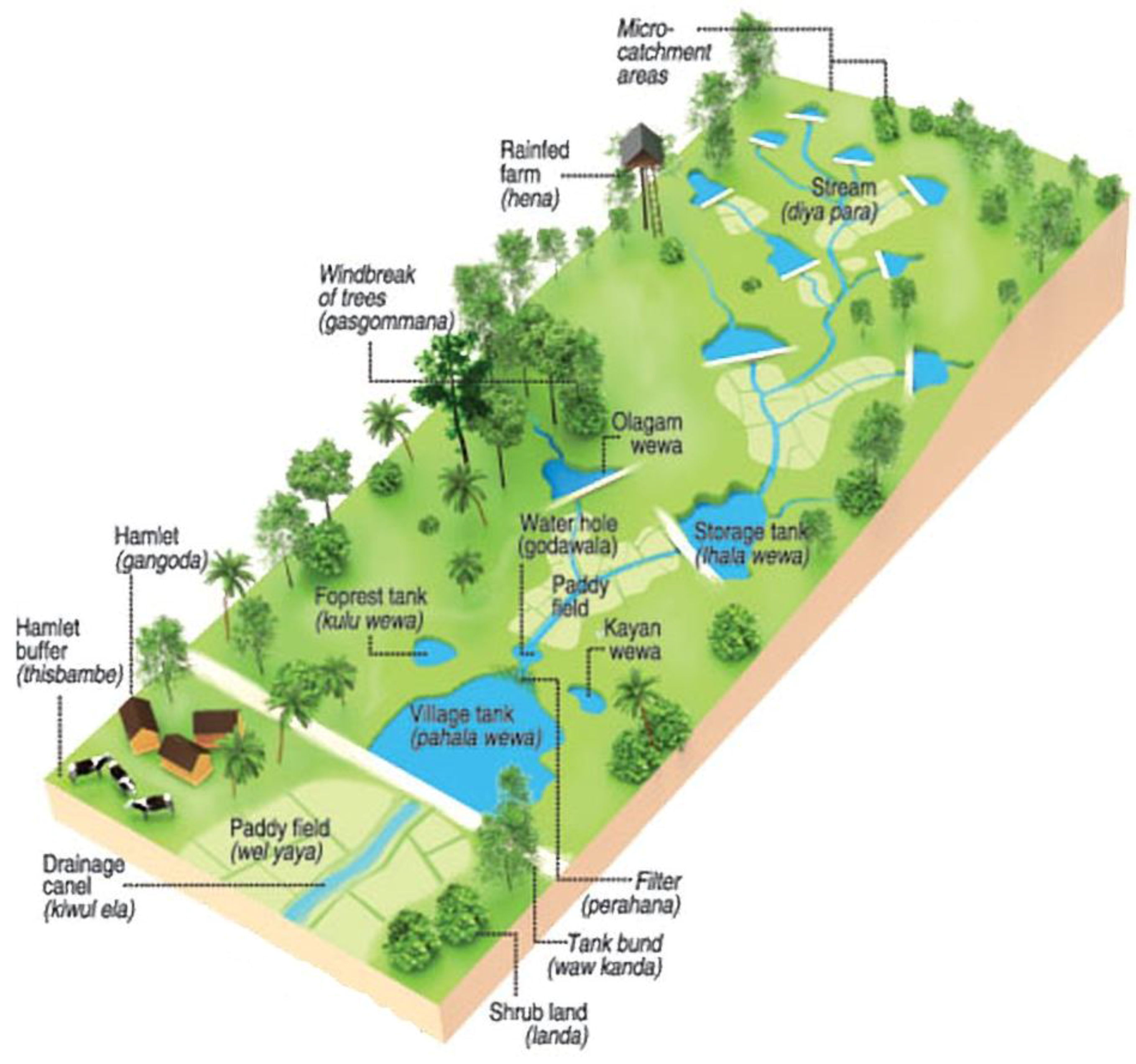
The tank cascade system of water management was first described as such by Bandara [
16] to explain the networks of small tanks to large reservoirs that still exist in modern-day Sri Lanka. These ancient irrigation structures evolved with the advancement of traditional knowledge over two millennia and still act as essential elements of water management for agriculture in the dry zone of Sri Lanka. The main principle behind the tank cascade system is recycling and re-use of water through a network of small to large tanks. Brohier [
17] has also described village tanks and their association with ancient irrigation works in Sri Lanka. A ‘cascade’ is a connected series of tanks organized within a micro- (or meso-) catchment of the dry zone landscape for storing, conveying and utilizing water from an ephemeral rivulet [
16]. Each of these cascades delineates a distinct small watershed or meso-catchment ranging in extent from 13 to 26 km
2 with an average extent of 20 km
2 (see
Figure 1).
Tanks are the building blocks of the tank cascade system (forming a subsystem) and are the components that make up this interwoven irrigation network. Tanks, paddy fields, watersheds and canals are integrated and interwoven with the natural environment (naturalized) [
18], facilitating the evolution of the cascade system over two millennia. The tank cascade system of water management, as can be seen, utilizes rainwater as well as small streams as water sources. The water is stored in small tanks and used for cultivation of the tank downstream areas; once used, the water then trickles down to progressively larger tanks. This system is very different from the other type of irrigated water management system described in this paper, the modern surface irrigation system [
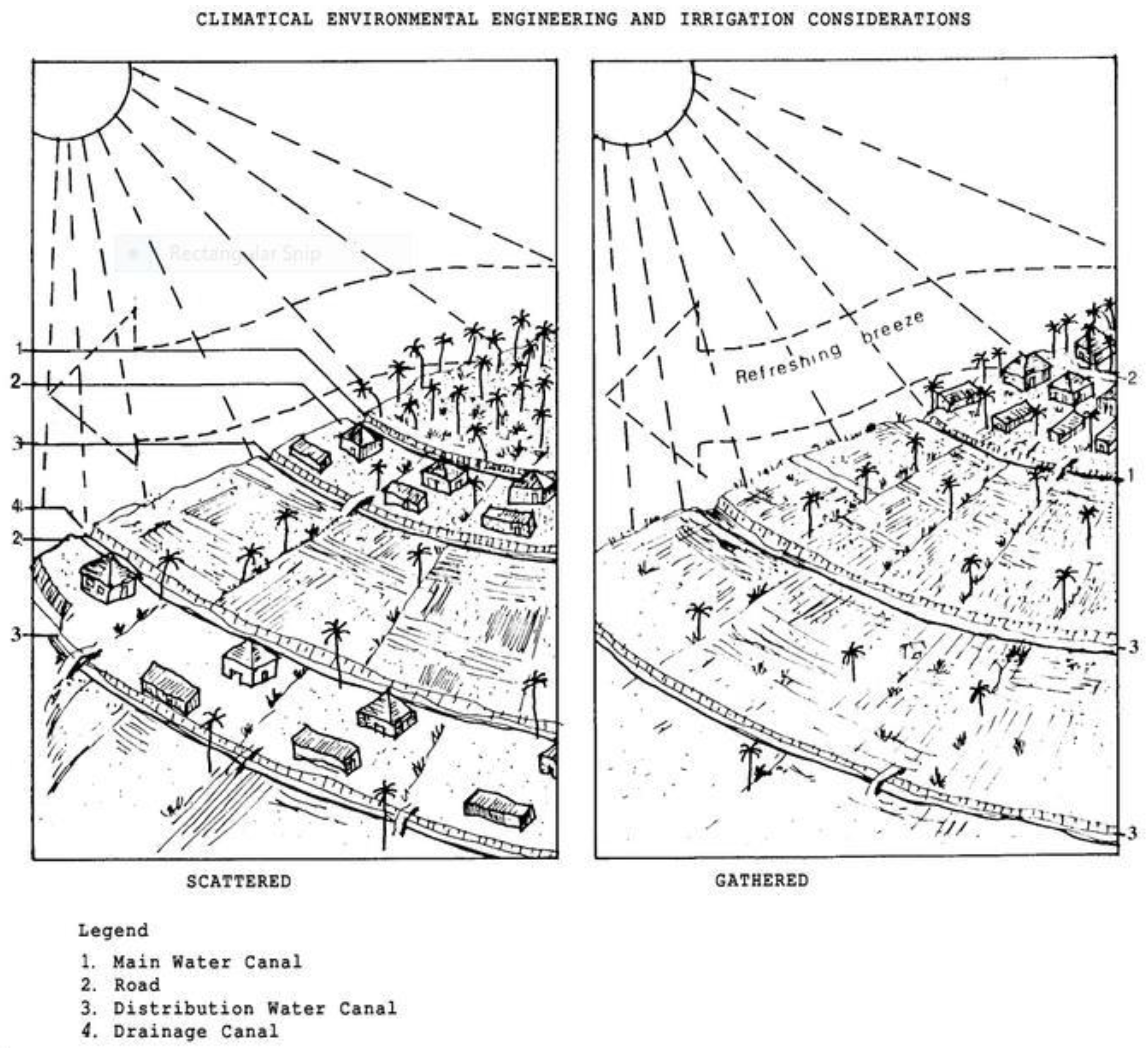
19]. In the modern system, a stable water source (such as a large-scale river) is employed to systematically distribute water across fields using gravity via an intricate network of canals.
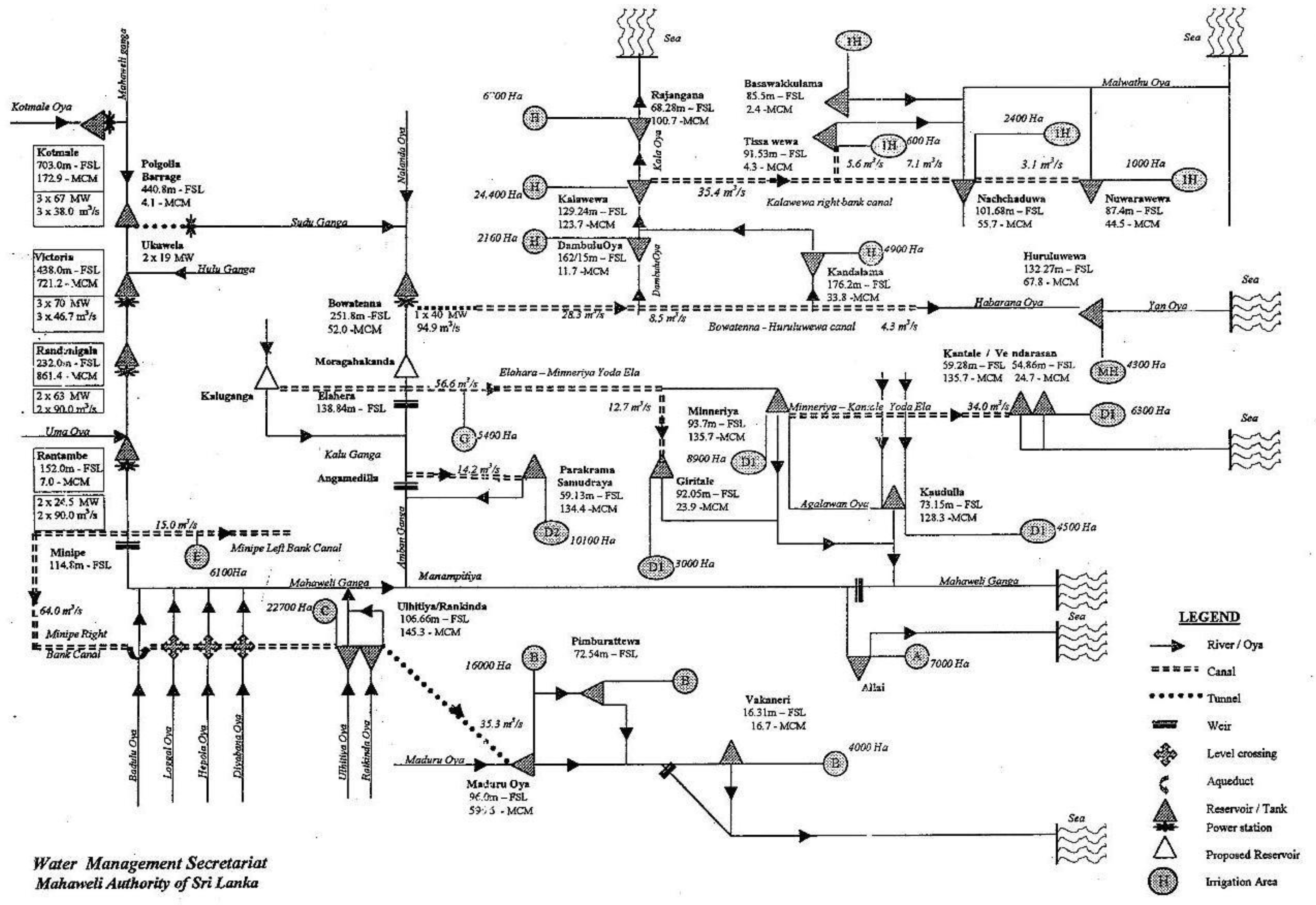
The modern surface irrigation system design has been used in Sri Lanka when designing water infrastructure for large-scale state-sponsored agricultural extension programs such as the Mahaweli Development Project. The Mahaweli project in Sri Lanka is also one of the largest irrigation development programs in the world [
19,
20]. The surface irrigation system design in the Mahaweli project uses the Mahaweli River (the longest river in Sri Lanka and the eponym for the project) as a year-round stable water source. The water from the Mahaweli River is used to feed tanks at strategic locations. Then, a network of canals is created starting from the main canal and splitting off into branch canals (or B-canals), distribution canals (or D-canals), sub-distribution canals (or SD-canals) and field canals. The engineers assume a predetermined canal slope and apply hydraulic equations to determine the slopes and cross sections of the canal that will allow it to convey water via gravity to cultivate the maximum possible area. In this design, the canals are arranged in a rigid matrix-like grid composed of straight lines—both horizontal and vertical. Landscape features such as forest patches existing in these potentially irrigable areas are cleared to make the topography even and flat. Independent farming plots are then created along the canal networks, as is housing for farmers (see
Figure 2). This is another key difference from the tank cascade system mentioned earlier in this paper, as in the former system, downstream farmers’ residences are often arranged in a cluster (called
Gangoda in Singhalese) some distance from the farmers’ respective fields, while the modern system provides farmers with housing that is virtually on or near their irrigable land plots.
3. Materials and Methods
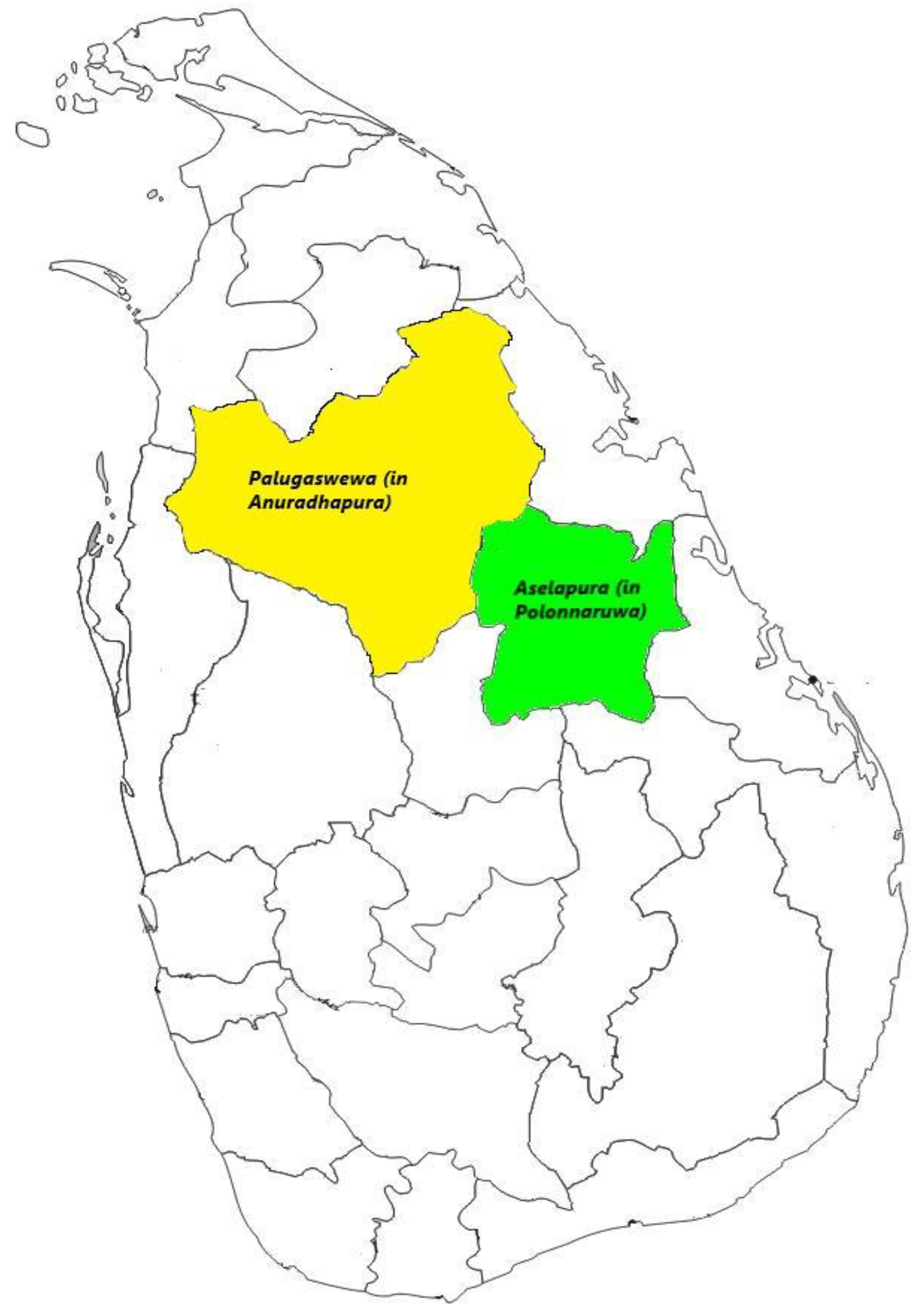
The present work grew out of ethnographic fieldwork conducted in Sri Lanka for over a year, from March 2017 to May 2018. The fieldwork was carried out in 2 of the 26 districts in Sri Lanka:
Anuradhapura and
Polonnaruwa. Both districts, situated in the North-Central Province, are key irrigation districts in Sri Lanka. Anuradhapura has several existing tank cascade systems, of which the
Palugaswewa cascade was chosen for the study. Polonnaruwa, on the other hand, has a surface irrigation system established under the Mahaweli project in the village of
Aselapura; which was examined in an effort to understand the effects of the surface irrigation infrastructure on the community from a socio-political standpoint. The two districts are presented below in
Figure 3.
In both instances—when examining the tank cascade system in Palugaswewa, and the surface Irrigation system in Aselapura—the case study method was utilized as the preferred study-design. This was due to the fact that the results of the present study—that specific arrangements of the water infrastructure could affect the way social groups are configured—primarily take the form of observations which are highly context-dependent; that is, the phenomenon that is analyzed in this study is not distinct from the context. Furthermore, there are many instances in the socio-political literature on water management where the case study approach has been successfully utilized to conduct an empirical inquiry about the real-life dynamics and social-effects of water management [
1,
12,
14]. To improve the validity of findings that the present research will generate, the author has utilized multiple methods of inquiry (see below) when collecting data in each setting.
Data Collection Methods
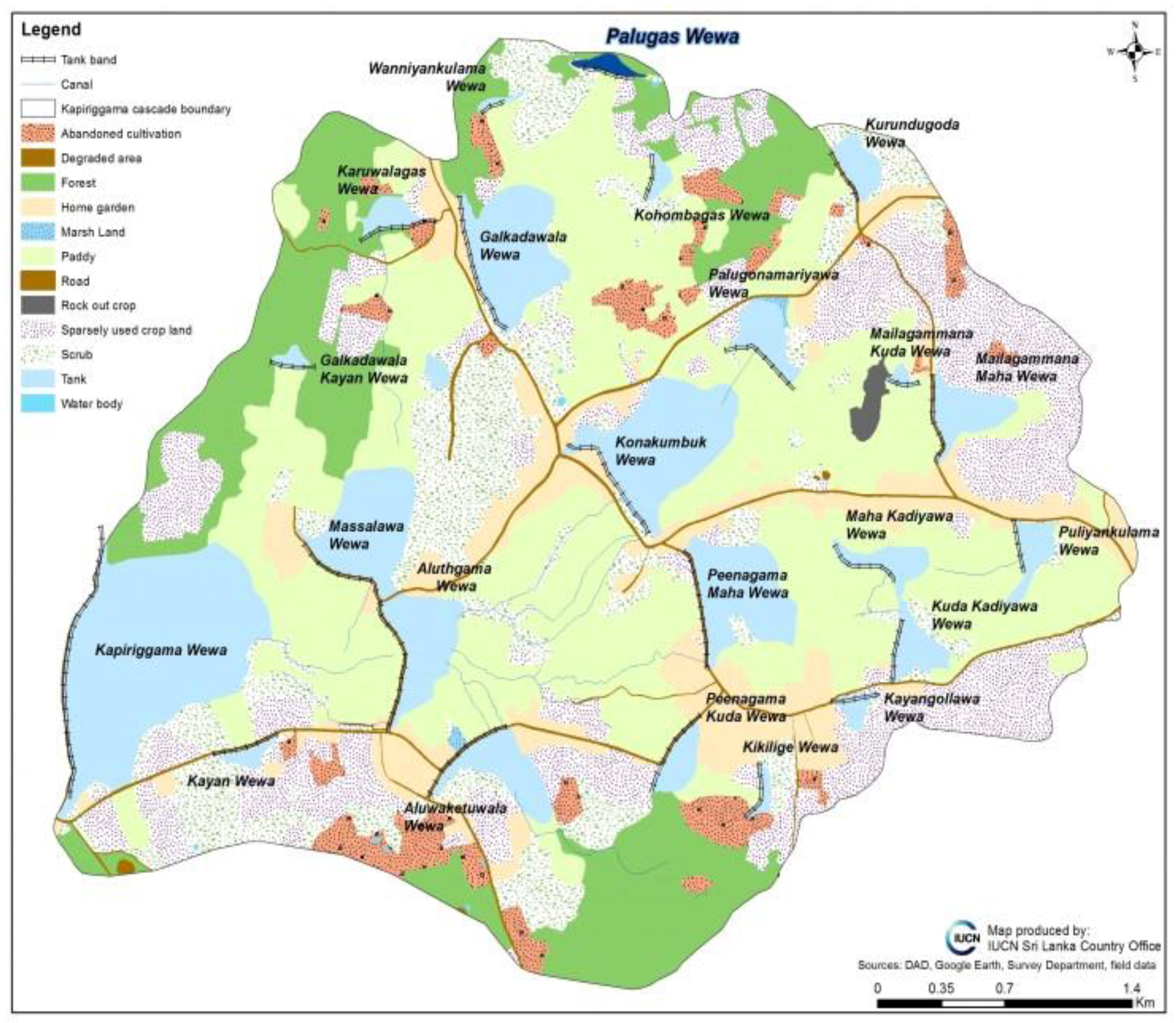
Data collection in the Palugaswewa tank cascade system was performed using a qualitative methodology consisting of observation (recorded in a field diary), a combination of semi-structured and unstructured interviews with the farmers (N = 40) and focus group discussions with 8–12 farmers (N = 2). The author was also able to take part in a bi-annual
Kanna meeting in which decisions regarding seasonal cultivation are made. The collection of such primary data was supplemented by detailed maps of the water infrastructure in the tank cascade system (reproduced in
Figure 4), documents describing land-use patterns and land tenure systems, and a comprehensive layout of cultivated land plots, which were obtained from the resident offices of the International Union for Conservation of Nature (IUCN) and the District Secretariat.
Similar methods were used to collect data in the Aselapura surface irrigation system as well. The investigation was framed by a qualitative methodology that consisted of observations (recorded in a field diary), a combination of semi-structured and unstructured interviews with the farmers (N = 36) and focus group discussions with 8–12 farmers (N = 3). Since the surface irrigation system is centrally administered by the offices of the Mahaweli Development Project, I also interviewed (as key informants) the resident project manager (RPM), the irrigation engineers for the division and several unit managers, whose tasks include overseeing water management processes in Aselapura, maintaining the quality of irrigation infrastructure, and liaising between farmers and the Mahaweli project.
As mentioned previously, a major difference between the tank cascade system design and the surface irrigation system design found in Aselapura is that the infrastructure of the latter is organized in a grid-like arrangement of straight horizontal and vertical lines. To visualize the infrastructural design difference between the tank cascade system and the surface irrigation system, the layout of a cross section of the dam, tank and canal network as created by the Mahaweli project is presented below (see
Figure 5).
4. Results
This section presents an account of how the differences in the infrastructural layout between the tank cascade system and the more modern surface irrigation system tend to transform the relationships between people in the downstream communities in a variety of ways as well as change their outlook and perceptions regarding water.
4.1. Collectivist versus Individualist Points of View
The first significant difference between farmers in the tank cascade system and farmers in the surface irrigation system is that farmers in the tank cascade system are more ‘bound’ together than the farmers in the surface irrigation system. This difference in outlook can be directly attributed to the arrangement of the farms and households in the two irrigation systems. In the tank cascade system, the farms owned by individual farmers are arranged in a cluster in the areas downstream of the tank, while the farmers’ residences are again arranged in a different cluster further away in a hamlet called a
Gangoda (literally meaning village cluster) in Sinhalese (see
Figure 1). Thus, the farmers have quite a distance to travel from their homes to reach their respective cultivation plots. Since the farms are some distance away, the farmers cannot effectively respond to nighttime threats to their farms posed by wild animals (especially elephants), requiring the farmers to coordinate a night-watch on a rotational basis. Furthermore, there is evidence to suggest that such coordination among farmers has also led to the communal regulation of production processes and cultivation. This system of coordination among farmers is strengthened by a variety of social norms and values as well as kinship obligations. According to one farmer:
“… All of the major milestones that come up in seasonal cultivation have to be achieved at the same time by all the farmers. Farmers can decide when to harvest their farms, but often all the farms are harvested within days of each other. And all the villagers get together to help each farmer with their harvesting; it’s like a festive event. The wife of the farmer [whose lands are being harvested] plays the role of the host, and the other ladies of the village all come and help her cook and set up lunch for the men working in the field …”
(Field notes translated, 2017–2018)
Furthermore, if a particular farmer cannot tend to or harvest his field due to sickness or some other adverse circumstance, it is standard practice for the other farmers to cultivate and harvest his crop, which is then given to the affected farmer’s family.
This system of cooperation existing among cascade farmers is very different from the individualistic attitudes expressed by farmers in the surface irrigation system, and this difference can be traced back to the layout of the water infrastructure. In the surface irrigation system layout of the Mahaweli project, each individual farmer receives a plot of farm land and a plot in the highlands to build a home, and the two plots are often adjacent to each other. This is possible because water can reach each farm individually by virtue of the extensive network of canals, whereas in the tank cascade system, the farming plots are clustered immediately downstream of the tank. Thus, the cooperation among farmers in the tank cascade system is not required in the surface irrigation system, since the 2.5 acre “family farm” provided in the latter is a farm in itself. While it is in every famer’s interest to get an “adequate” amount of water for cultivation, whether others get water or not could be—from the production organizational point of view of the individual farmer—rather irrelevant. Furthermore, the conditions under which some of the farmers obtain water do not require cooperation. A limited or rational use of water is not necessarily in the interest of the individual farmer who is well placed—at least from the perspective of the relations within a turnout area.
It is also interesting to note that the water officer—who oversees water management at the ground level and who mediates water needs between the farmers and the Mahaweli project—deals primarily with farmers individually. The most vocal farmers are attended to; the others receive considerably less attention. Thus, water complaints are interpreted in practice as the business of one individual farmer, who asks the water officer to assist him. According to field observations, the water officer (or Jalapalaka in Singhalese) does not often approach the farmers as a group, which encourages the overall individualistic attitudes of the farmers.
4.2. Head-End Farming versus Tail-End Farming in Surface Irrigation Systems
A second observation that is specific to the surface irrigation system and is not relevant to the tank cascade system is related to the differences noted between head-end farmers and tail-end farmers along a canal. In the surface irrigation system, when water is released through the distribution canals, the farmers at the beginning (the head end) of the canal receive their quotas of water prior to the farmers who own plots towards the end of the canal (the tail end). While in principle the amount of water issued by the water officers to the farmers should be the same for each, this does not often happen in practice, partly due to the individualistic attitudes of the farmers mentioned above. In reality, the farmers cultivating at the tail end of the canal receive substantially less water than their head-end counterparts for various reasons. The first reason is that the condition of the canals deteriorates (creating cracks and potholes on the canal floor) over time, and this affects the quantity and quality of the water flow, especially towards the tail end of the canal. Secondly, farmers at the head end usually take more than their allotted portion of water unless water quotas are strictly enforced. In the words of one water officer:
“… We have to work around the clock to make sure that the head-end farmers do not take more than their fair share of water. Sometimes we get complaints from tail-end farmers that so-and-so [head-end farmers] has opened their field canal late at night to get more water from the distribution canals. We have to then go and see to what is happening and stop it …”
(Field notes translated, 2017–2018)
Clearly, the individualistic attitudes towards water and the lack of a cooperative spirit play a role in these circumstances. Furthermore, it also appears that the head-end and tail-end water disparities have led to the downstream communities being stratified in various ways. For one, the tail-end farmers are more likely to grow alternative field crops on their farms instead of paddy, as is the norm, presumably because paddy is a water-intensive field crop requiring copious quantities of water. Often, such alternative field crops yield less money due to uncertain market conditions (unlike paddy, which has a stable price), leading to economic stratification between head-end and tail-end farmers. Interviews with the farmers in surface irrigation systems revealed that the second and third generations of tail-end farming families were more likely than their head-end counterparts to look for alternative employment rather than continue to farm.
Conversely, such forms of social stratification do not occur among farmers in the tank cascade system, since water in such systems does not follow a linear canal network, and social cohesion and cooperation among farmers is higher than among farmers in a surface irrigation system. Thus, this finding reveals one of the ways in which water infrastructure itself creates different social and economic configurations among downstream populations.
4.3. Water Infrastructure and Land Sharing
A third difference between the tank cascade system and surface irrigation system is related to land-sharing patterns. Occasionally, the occurrence of a drought will deplete the available water in the tanks. Droughts influence the tank cascade system more than they affect the surface irrigation system, since the water source for the former is rain and small-scale streams rather than a large river. When drought occurs, the farmers in the tank cascade system use a method known as “share-cropping” or Bethma cultivation, in which farmers whose farm lands do not receive water lend their labor to farms that do. However, this practice does not create a legal bond between the parties involved—it is more an act of cooperation enforced by kinship norms and values. For instance, cultivable farm lands are most often shared between members of the same kinship group, also known as the Variga, and occasionally between neighbors.
This practice contrasts with the situation in surface irrigation systems, where a lack of water for some farms does not easily lend itself to a situation of share-cropping. Often, tail-end farmers (who receive substantially less water in times of drought) will lease their lands to third-parties for cultivation under a contract (for a percentage of what is cultivated) and then seek employment elsewhere (as wage laborers or contractors, for instance).
4.4. The Many Uses of Water: Cultivation, Drinking and Cattle Farming
Another way in which different layouts of water management infrastructure result in different social configurations can be understood by examining the different uses of and perspectives on water itself.
Figure 1 and
Figure 4 show that the tank cascade system consists of an interwoven network of tanks, watersheds and canals, in alignment with the natural environment. This arrangement of water infrastructure has, within communities, led to a holistic understanding of water as part of the ecology. Thus, a tank or
Wewa is not seen as merely a source of cultivation. Rather, it is a source of water in general, water that is used for fisheries, cleaning and drinking purposes. In contrast, in the surface irrigation system, there is very much a separation of water from its source—the Mahaweli River and the large-scale storage tanks. People in the surface irrigation system do not see water at its source, only as it flows through the canals into the fields. This separation has important implications.
In surface irrigation systems, water is perceived as a commodity that flows through canals into the fields—as purely a necessity for cultivation. Thus, the concept of water itself is seen from a reductive standpoint as an economic good. As a result, people must look elsewhere to find water for other purposes such as drinking and cleaning. In Aselapura village, where the present study was carried out, there is a general lack of groundwater, and only approximately 1 house in 3 has access to an operational well. Thus, people endure considerable hardship because of the lack of an adequate supply of drinking water, even though—ironically—the whole village is surrounded by water from the canals. Thus, water infrastructure arrangements can result in a segregated and reductive understanding of the very ontology of water, a point made by Barned and Alatout [
22] in their introduction to the special issue on water appearing in the
Social Studies of Science. Furthermore, in Aselapura, the non-existence of a steady drinking water supply has led to several intermediaries engaging in the commercialized production of bottled water and selling this water at higher than market rates. The existence of multiple small-scale water networks where larger networks to supply drinking water do not exist or have broken down has also been observed by Bakker [
8]. The differences in water management infrastructure have severe health implications as well: in the surface irrigation system of Aselapura, many individuals have chronic kidney disease. In the tank cascade system, on the other hand, such diseases do not exist.
5. Discussion
The previous section revealed at least four variations on a single theme: that differences in water management infrastructure lead to different social, economic and political configurations among downstream communities. Two systems of water management for irrigation in Sri Lanka were analyzed comparatively: the tank cascade system layout and the surface irrigation system layout. In each case, the different ways in which the waterscapes are arranged lead to a number of consequent social configurations.
As noted in the introduction, this understanding of water management infrastructure ties in with the modern perspective on water in the literature: the concept of ‘water worlds’. The present study directly contributes to this body of literature by demonstrating how the physical layout of water infrastructure effectively gives rise to different outlooks and rationalities (i.e., the individualist and collectivist outlooks among farmers); strengthens or weakens communal cooperation; creates social stratification among farmers at different ends of the canal; and influences the farmers’ perception of the very concept of ‘water’ as an economic good. Understanding this close association between the water management infrastructure and society, therefore, requires a sophisticated explanatory and theoretical framework. The best way in which the close relationship between water management infrastructure and society can be understood is by using Latour’s [
23] conceptualization of socio-material assemblages, as it refers to a multi-semiotic framework that connects human and non-human entities [
23,
24,
25,
26].
One advantage of using such a framework to explain the findings of the present work and to further the idea of ‘water worlds’ is that it does not create a conceptual separation between ‘technical systems’ of water governance (the infrastructural layout) and the socio-political system. At the beginning of this work, the various perspectives that have dominated and directed the water management literature at various times, including the post-colonial state-based perspective, the neo-liberal hydro-mentality, and the integrated water resource management framework, were discussed. However, a common weakness of all these frameworks is that they create an artificial separation between technical systems and human systems [
27]. In contrast, Latour’s insights into socio-material assemblages emphasize the constitutive entanglement of the social and the material in everyday organizational life, thus eroding this separation [
28]. It is the view of this author that the findings of the present work call for just such a framework of analysis, in which the water management infrastructure and the downstream communities are considered as folded into the layers of an intricate network.
Importantly, the present work does not intend to conclude that either the tank cascade system or the surface irrigation system is more beneficial but merely seeks to present a value-neutral and descriptive analysis. Furthermore, since the present work necessarily limits itself to two systems of irrigation infrastructure, it does not enable us to draw generalizable conclusions or extrapolate the socio-political effects that have been discussed here to a different context, such as an urban water supply. As we have noted, discussing the socio-materiality of water management is a highly context-dependent enterprise; therefore, it is likely that the socio-political effects generated in an urban context would be very different from those discussed in this work. Despite this, the central findings of the present work could potentially be used to understand the
systemic or infrastructural basis for social effects among the farmers. As such, studies similar to the present work may be used to understand the potentially beneficial or harmful effects caused by a particular infrastructure arrangement. For instance, the income disparities that were identified between head-end and tail end farmers in the present study (see
Section 4.2) have also been identified in Egypt [
29]—this fact suggests that at least one adverse effect of surface irrigation systems (as it has been described in this work) is not merely limited to the Sri Lankan context. By undertaking further research into analyzing the social consequences fostered by the technical systems of water management, one would be in a position to reach important policy decisions that are increasingly sensitive to the social dimensions of water management.
6. Conclusions
The present work seeks to offer a modest contribution to the literature on water management, water infrastructure and water governance by drawing from a case study conducted in Sri Lanka to comparatively examine two different water management infrastructures utilized for irrigated cultivation and analyze the social, economic and political configurations and effects that arise from them. The results show that different infrastructural layouts between the tank cascade system in Palugaswewa, Anuradhapura, and the surface irrigation system established by the Mahaweli Development Project in Aselapura, Polonnaruwa, lead to very different social configurations, outlooks and perceptions.
The importance of treating the relationship between water management infrastructure and society as a complex socio-material assemblage has also been noted in this study. Typically, social or historical analysis regarding water and water infrastructure has downplayed the contingency of these systems [
30,
31]. Even a probabilistic social science, however careful it may be about establishing a range of outcomes, is apt to treat these probabilities—for the sake of analysis—as solid facts [
32,
33]. To an extent, the present work represents a caution against such a reductive analysis of water infrastructure and technical systems, as such an approach might result in certain unintended contingencies that are beyond the planners’ grasp. Alternatively, this work suggests that the social effects caused by the infrastructural arrangements should be seriously considered in the design and implementation of the technical systems of water management. Developing such a sensitivity may serve to reduce any potential social costs associated with certain infrastructural layouts and may also improve the sustainability of the systems overall.


