Next Article in Journal / Special Issue
Reply to “Comments on ‘Spatial and Temporal Trends in the Location of the Lifetime Maximum Intensity of Tropical Cyclones’”
Previous Article in Journal
From Tropospheric Folding to Khamsin and Foehn Winds: How Atmospheric Dynamics Advanced a Record-Breaking Dust Episode in Crete
Previous Article in Special Issue
Snow Level Characteristics and Impacts of a Spring Typhoon-Originating Atmospheric River in the Sierra Nevada, USA
 
 
Reply published on 25 June 2018, see Atmosphere 2018, 9(7), 242.
Comment

Comment on “Spatial and Temporal Trends in the Location of the Lifetime Maximum Intensity of Tropical Cyclones” by Tennille and Ellis

NOAA National Centers for Environmental Information, Madison, WI 53706, USA
Atmosphere 2018, 9(7), 241; https://doi.org/10.3390/atmos9070241
Submission received: 29 April 2018 / Accepted: 21 June 2018 / Published: 25 June 2018
(This article belongs to the Special Issue Tropical Cyclones and Their Impacts)
The latitude where tropical cyclones (TCs) reach their peak intensity has migrated poleward in some regions [1] (Kossin et al. 2014, hereafter KEV), and this can substantially affect regional TC hazard exposure [2] (Kossin et al. 2016, hereafter KEC). The migration rates are generally consistent with independently observed rates of tropical expansion [1,3], suggesting that the two may be linked. The changes in TC hazard exposure patterns and the potential linkage to the expansion of the tropics, which in turn has been linked to anthropogenic forcing, heightens the relevance of the poleward migration of TCs, and further studies are needed to better understand this phenomenon. Tennille and Ellis [4] (hereafter TE) undergo such a study and find that (1) the migration of the latitude of peak intensity in the North Atlantic is equatorward in the period 1977–2015; and, (2) the migration rate in the western North Pacific becomes significant at less than a 95% confidence level when the time series is altered from that of KEV. The additional analyses performed as a follow-up to KEV are welcomed, but there are some aspects of TE where additional context and clarification would be informative.
KEV focused on a global view of the location where tropical cyclones reach their peak intensity, and found a significant global-mean poleward migration that had positive contributions from the western and eastern North Pacific, Southern Indian, and South Pacific Oceans. These regions comprise the bulk of observed global TC activity. Their analyses, which were based on the historical “best-track” data [5], were constrained to the period starting in 1982 in order to make comparisons with a more homogeneous global dataset based on satellite data. The global focus of KEV provided a significant and robust rate of expansion of the regions where TCs reach their peak intensity, and they found very good agreement of this rate in the more homogeneous dataset. As expected when sub-setting larger datasets, the robustness of the trends was substantially reduced within the individual ocean basins due to decreased signal-to-noise ratios. The period of analysis of KEV was relatively short, but they emphasized that focusing on the location of peak intensity allows for much greater confidence when extending the period of analysis back further in time.
KEC, which was not cited by Tennille and Ellis (TE), exploited this strength of the metric and considered the annual-mean location of peak TC intensity in the western North Pacific over the substantially longer period 1945–2013. This allowed for them to account for the known regional modes of inter-annual and decadal variability by regressing the position of peak intensity onto indices of the El Niño/Southern Oscillation (ENSO) and the Pacific Decadal Oscillation (PDO).
When this was done, the poleward migration rate identified by KEC in the recent period 1980–2013 was reduced, but it remained significant (Figure 6 and Table 1 in KEC using best-track data from the Joint Typhoon Warning Center). The analysis of KEC is updated here to the period 1945–2015 (Figure 1). This is an important result that enables a more confident statement that there is a detectable trend in this region. That is, a significant and linearly steady long-term trend remains after accounting for the known dominant modes of (ostensibly) internal variability. This result was further supported by KEC using twenty-first century model projections that showed a continued poleward migration that is anthropogenically forced.
TE show that if the period of the time series is changed to 1977–2015, then the significance of the migration rate in the western North Pacific Ocean falls below the 95% confidence level [6]. While this result certainly presents a fair challenge to the robustness of shorter-term trends in an individual ocean basin (Figure 2), which are generally not expected to be very robust, as noted above, it misses the larger and more relevant point that a more robust long-term trend exists that accounts for the known dominant modes of regional variability, and this trend is consistent with numerical projections in a warming world. This is a key physical point that should not be obfuscated by the introduction of the statistical uncertainty that is inherent in the parsing of a longer time series.
A similar analysis that exploits the comparative temporal consistency of the metric of location of peak TC intensity can be performed in the Atlantic basin. Here, the dominant mode of decadal variability is generally described by the Atlantic Multi-decadal Oscillation (AMO) [7]. The relationship between the annual-mean meridional position of Atlantic TC peak intensity and the AMO is strong (Figure 3) and the transition to the present warm AMO phase that began in the 1970s is clearly associated with the equatorward migration of the location of peak intensity that is shown by TE (and by KEC in their Figure 1). The equatorward migration of Atlantic TC tracks has been previously documented (e.g., [8,9,10,11]) and is consistent with the migration of the latitude of peak intensity that is seen in Figure 3a. When the AMO is regressed from the longer time series of the annual-mean latitude of peak intensity, the migration rate is essentially zero (Figure 4).
To summarize, the potential for both Type-1 and Type-2 errors when considering relatively short time series of noisy geophysical data is underscored by the analyses of TE (and Figure 2 above), but this should not draw attention away from the more robust and relevant analysis of the longer-term trends, which are enabled by the comparative robustness of the metric being used. When these longer term trends are considered, the key findings are that (1) there is a steady and significant poleward migration of the location of peak TC intensity in the western North Pacific after accounting for the dominant modes of inter-annual and decadal variability in that basin; and, (2) the annual-mean latitude of peak TC intensity in the North Atlantic exhibits clear and substantial decadal variability that is largely controlled by the AMO, but it exhibits no clear long-term trend, and the more recent equatorward migration has simply followed the transition from cool to warm AMO phase that began in the 1970s. The first point is important because the long-term migration causes changes in regional TC hazard exposure [2], and the significance of the trend after accounting for internal variability provides confidence in the model-projected continuation of this migration into the twenty first century. The second point is important because it demonstrates that TC exposure in the North Atlantic is strongly controlled by the multi-decadal variability in that region, which is still not well understood [12]. A transition to a cooler AMO phase, should it occur, is likely to substantially change TC exposure patterns in the basin.

Acknowledgments

The author is supported by the NOAA National Centers for Environmental Information, Center for Weather and Climate.

Conflicts of Interest

The author declares no conflict of interest.

References and Notes

  1. Kossin, J.P.; Emanuel, K.A.; Vecchi, G.A. The poleward migration of the location of tropical cyclone maximum intensity. Nature 2014, 509, 349–352. [Google Scholar] [CrossRef] [PubMed]
  2. Kossin, J.P.; Emanuel, K.A.; Camargo, S.J. Past and projected changes in western North Pacific tropical cyclone exposure. J. Clim. 2016, 29, 5725–5739. [Google Scholar] [CrossRef]
  3. Lucas, C.; Timbal, B.; Nguyen, H. The expanding tropics: A critical assessment of the observational and modeling studies. Wiley Interdiscip. Rev. Clim. Chang. 2014, 5, 89–112. [Google Scholar] [CrossRef]
  4. Tennile, S.A.; Ellis, K.N. Spatial and temporal trends in the location of the lifetime maximum intensity of tropical cyclones. Atmosphere 2017, 8, 198. [Google Scholar] [CrossRef]
  5. Kossin et al. 2014 (KEV) omitted all dependencies on the absolute intensity estimates in the global best-track, and consequently their analyses included tropical depressions. Kossin et al. 2016 (KEC) slightly relaxed this constraint by removing these. This accounts for some of the differences between the two studies.
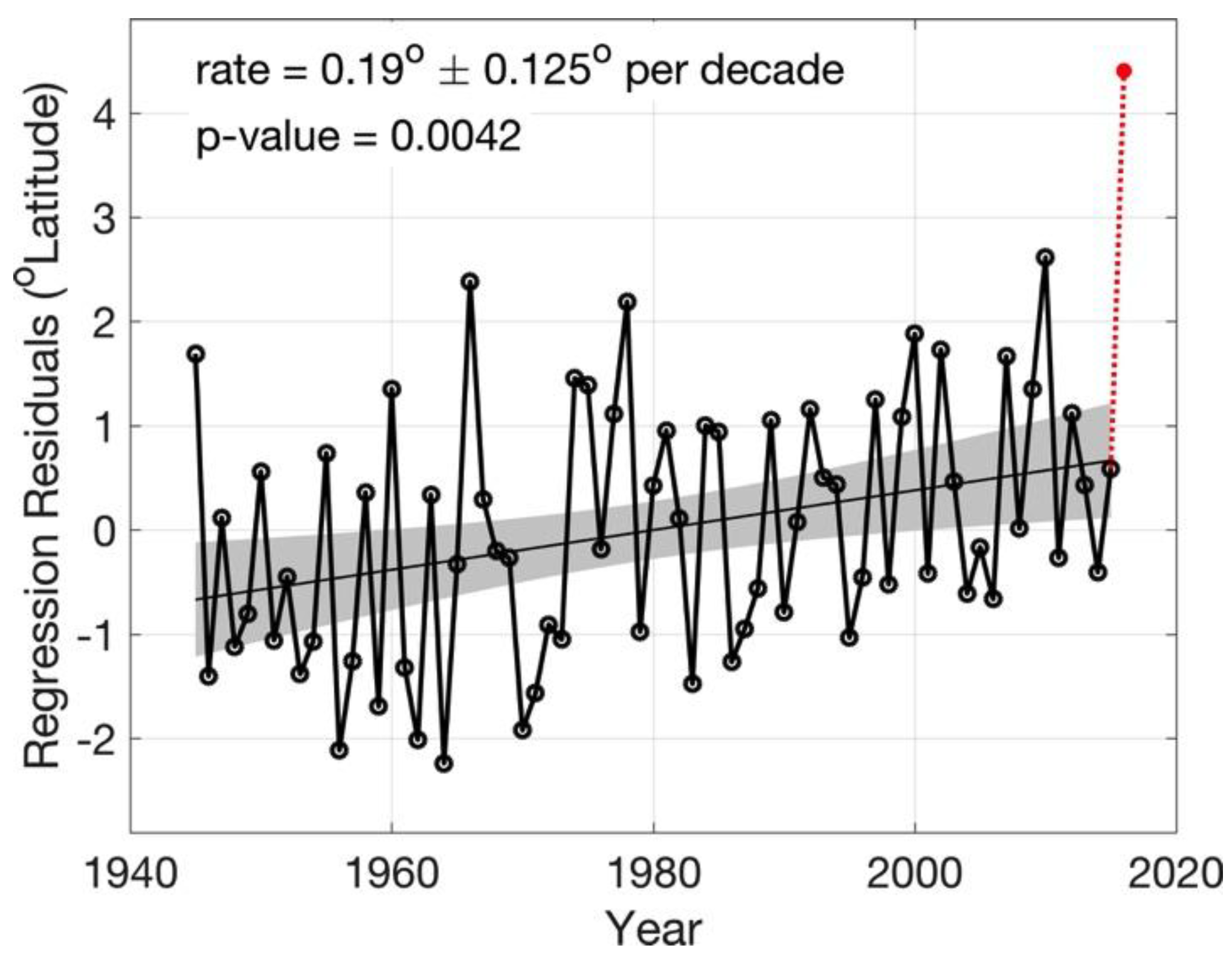
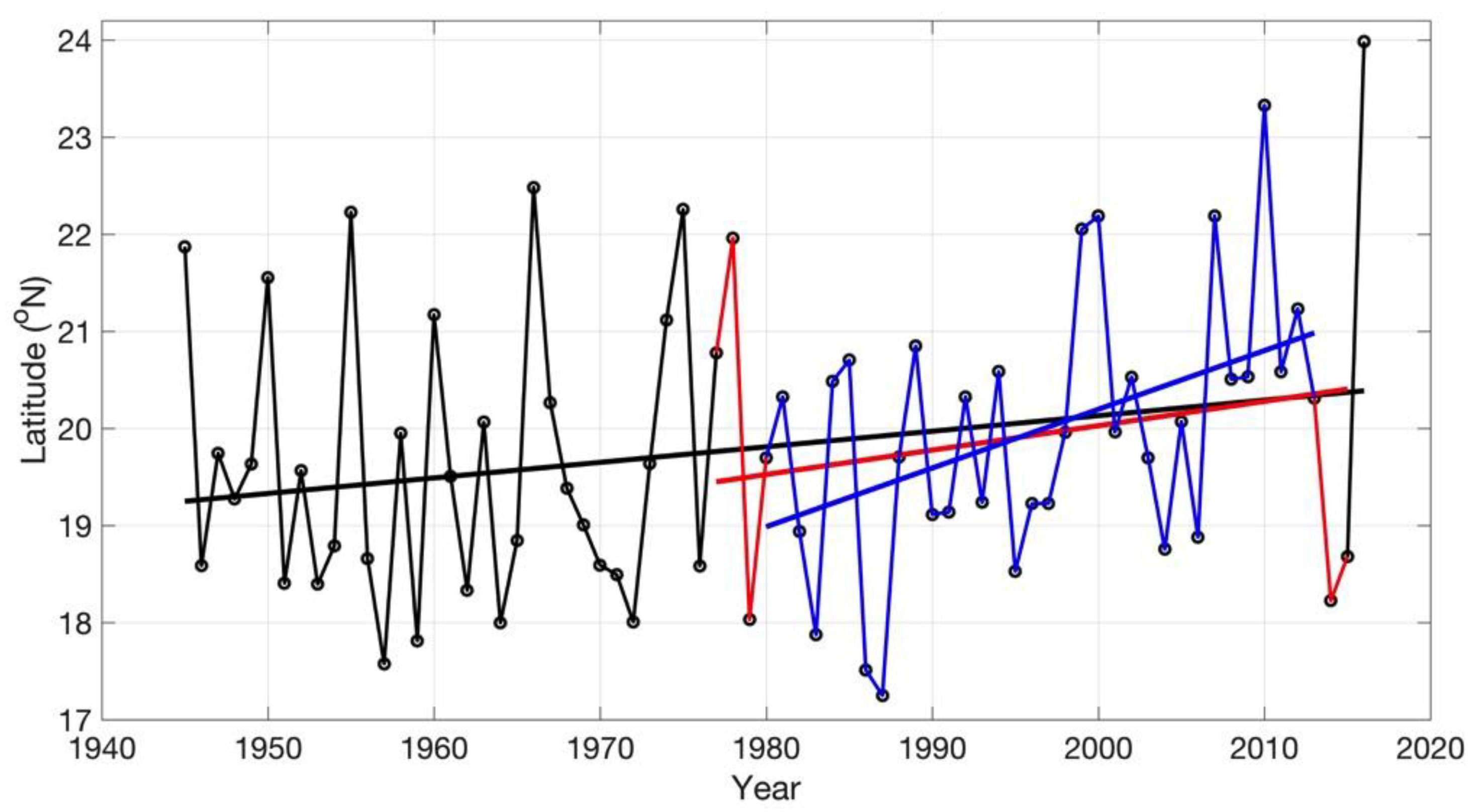
  6. Tenille and Ellis (TE) state that their analyses are constrained to begin in 1977 because no data were available in the western North Pacific best-track in 1976. In actuality, the data in that basin begin in 1945, and in 1976 the best-track contains data for 25 named storms, 10 typhoons, and four super-typhoons. There are no years that contain no data in the best-track for that region. The cause of this discrepancy is not clear.
  7. Enfield, D.B.; Mestas-Nunez, A.M.; Trimble, P.J. The Atlantic Multidecadal Oscillation and its relationship to rainfall and river flows in the continental U.S. Geophys. Res. Lett. 2001, 28, 2077–2080. [Google Scholar] [CrossRef]
  8. Kimberlain, T.B.; Elsner, J.B. The 1995 and 1996 North Atlantic hurricane seasons: A return of the tropical only hurricane. J. Clim. 1998, 11, 2062–2069. [Google Scholar] [CrossRef]
  9. Vimont, D.J.; Kossin, J.P. The Atlantic meridional mode and hurricane activity. Geophys. Res. Lett. 2007, 34, L07709. [Google Scholar] [CrossRef]
  10. Kossin, J.P.; Vimont, D.J. A more general framework for understanding Atlantic hurricane variability and trends. Bull. Am. Meteorol. Soc. 2007, 88, 1767–1781. [Google Scholar] [CrossRef]
  11. Kossin, J.P.; Camargo, S.J.; Sitkowski, M. Climate modulation of North Atlantic hurricane tracks. J. Clim. 2010, 23, 3057–3076. [Google Scholar] [CrossRef]
  12. Sobel, A.H.; Camargo, S.J.; Hall, T.M.; Lee, C.-Y.; Tippett, M.K.; Wing, A.A. Human influence on tropical cyclone intensity. Science 2016, 353, 242–246. [Google Scholar] [CrossRef] [PubMed] [Green Version]
Figure 1. Time series of residuals after regressing the annual-mean latitude of peak western North Pacific tropical cyclones (TC) intensity onto Pacific Decadal Oscillation (PDO) and El Niño/Southern Oscillation (ENSO) indices (July–November mean). The statistics shown (poleward migration rate, two-sided 95% confidence interval, and p-value) are based on the period 1945–2015. The residual for 2016, which had the northern-most mean latitude of peak TC intensity ever recorded in the western North Pacific best-track (see Figure 2 below), is shown by the red dot (this point is not included in the regression). Gray shading shows the two-sided 95% confidence bounds on the trend.
Atmosphere 09 00241 g001
Figure 2. The effect of adding the years 1977–1979 and 2014–2015 (red) to the western North Pacific time series of KEC, which spans the period 1980–2013 (blue), in the context of the longer time series (black). The longer-term (1945–2016) trend is 0.16° decade−1 (p-value = 0.05). The trend of KEC is 0.61° decade−1 (p-value = 0.007). The trend in the period used by Tennille and Ellis (TE) is 0.25° decade−1 (p-value = 0.20). The time series of KEC tends to exaggerate the migration rate, while the time series of TE is disproportionately affected by the end points.
Atmosphere 09 00241 g002
Figure 3. The relationship between the latitude of peak (lifetime-maximum) Atlantic tropical cyclone intensity and the Atlantic Multi-decadal Oscillation (AMO) index. Time series of (a) annually-averaged latitude of lifetime-maximum intensity, and (b) the AMO index. The raw time series (thin gray lines) correlate with R = −0.54 (p-value ~ 0). The smoothed time series (thick black lines) representing decadal variability correlate with R = −0.86. Cool (warm) AMO phase correlates with a poleward (equatorward) shift of peak intensity.
Atmosphere 09 00241 g003
Figure 4. Similar to Figure 1, but for the residuals of the regression of annual-mean latitude of North Atlantic peak TC intensity onto an AMO index.
Atmosphere 09 00241 g004

