
Impact of Radar Data Assimilation on the Simulation of Typhoon Morakot

Abstract
1. Introduction
2. Typhoon Review and Radar Observations
2.1. Morakot Review
2.2. Taiwan Radar Observation
3. Assimilation Strategy and Experiment Designs
3.1. ARPS3DVAR and Assimilation of Radar Data
3.2. ARPS Model and Domain Configurations
3.3. Experimental Designs
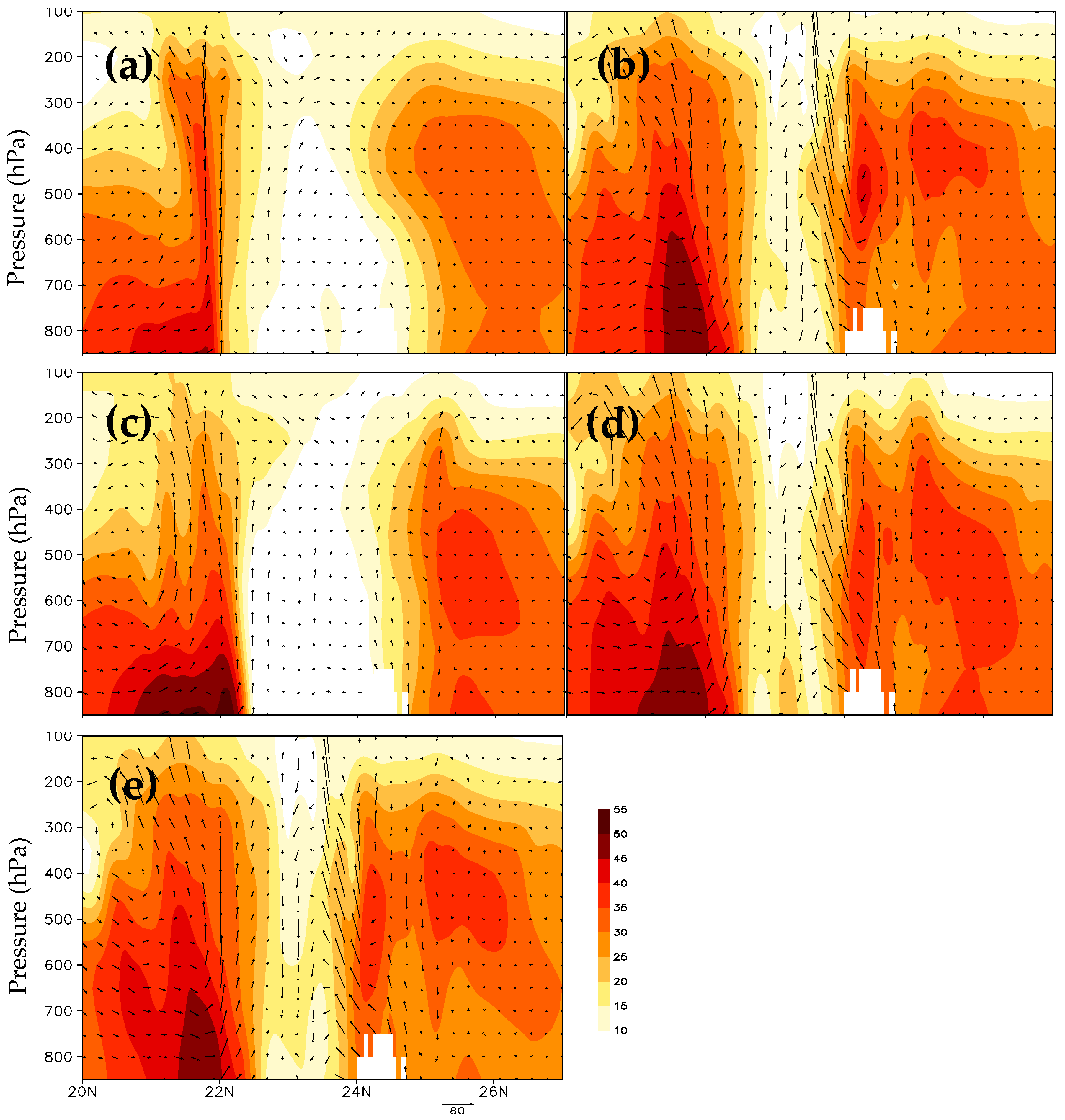
4. Assimilation Results of Radar Data
5. Result of Forecast
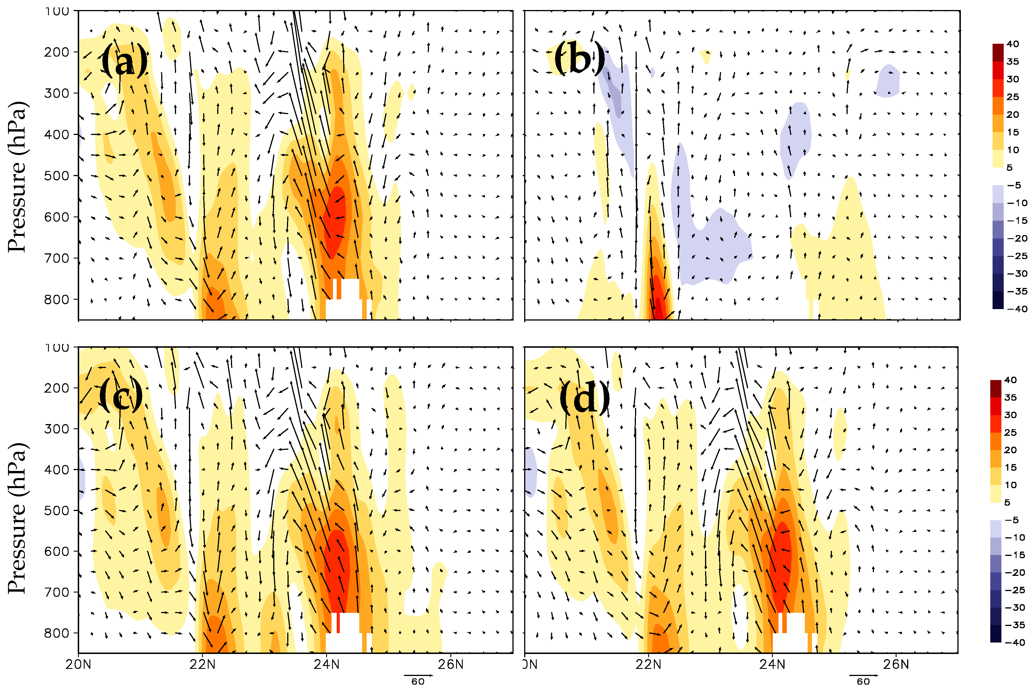
5.1. Radial Wind Forecast
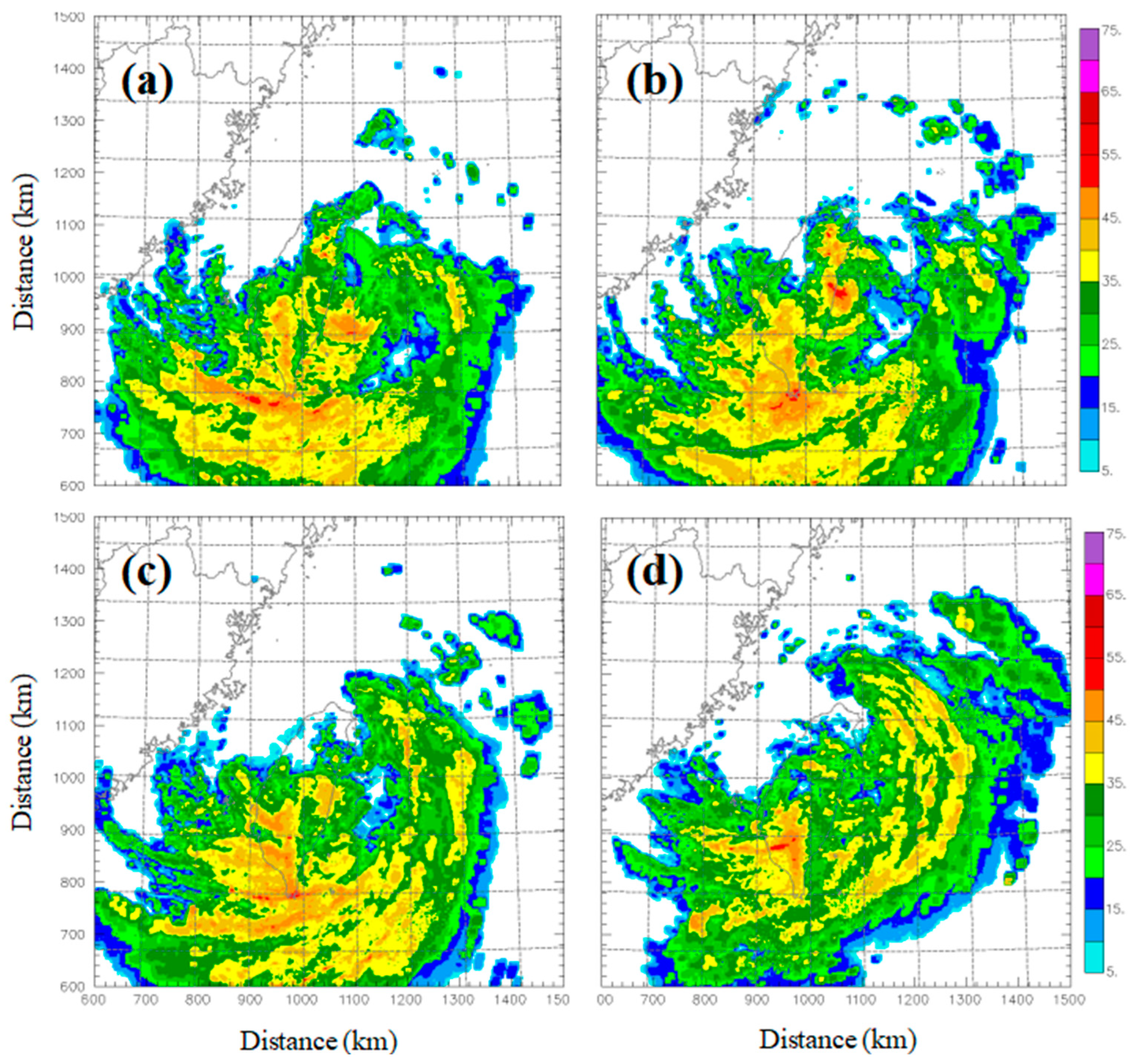
5.2. Reflectivity Forecast
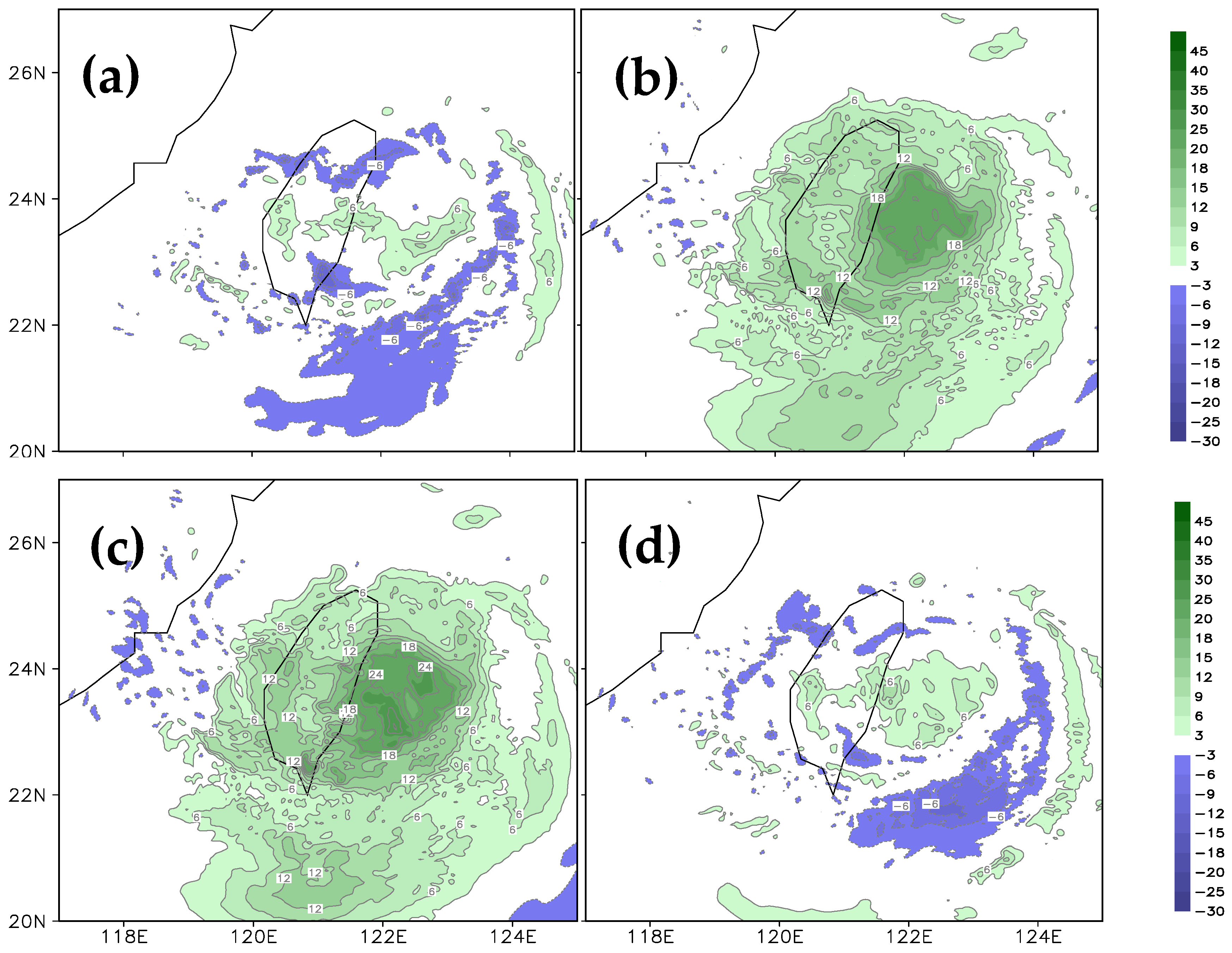
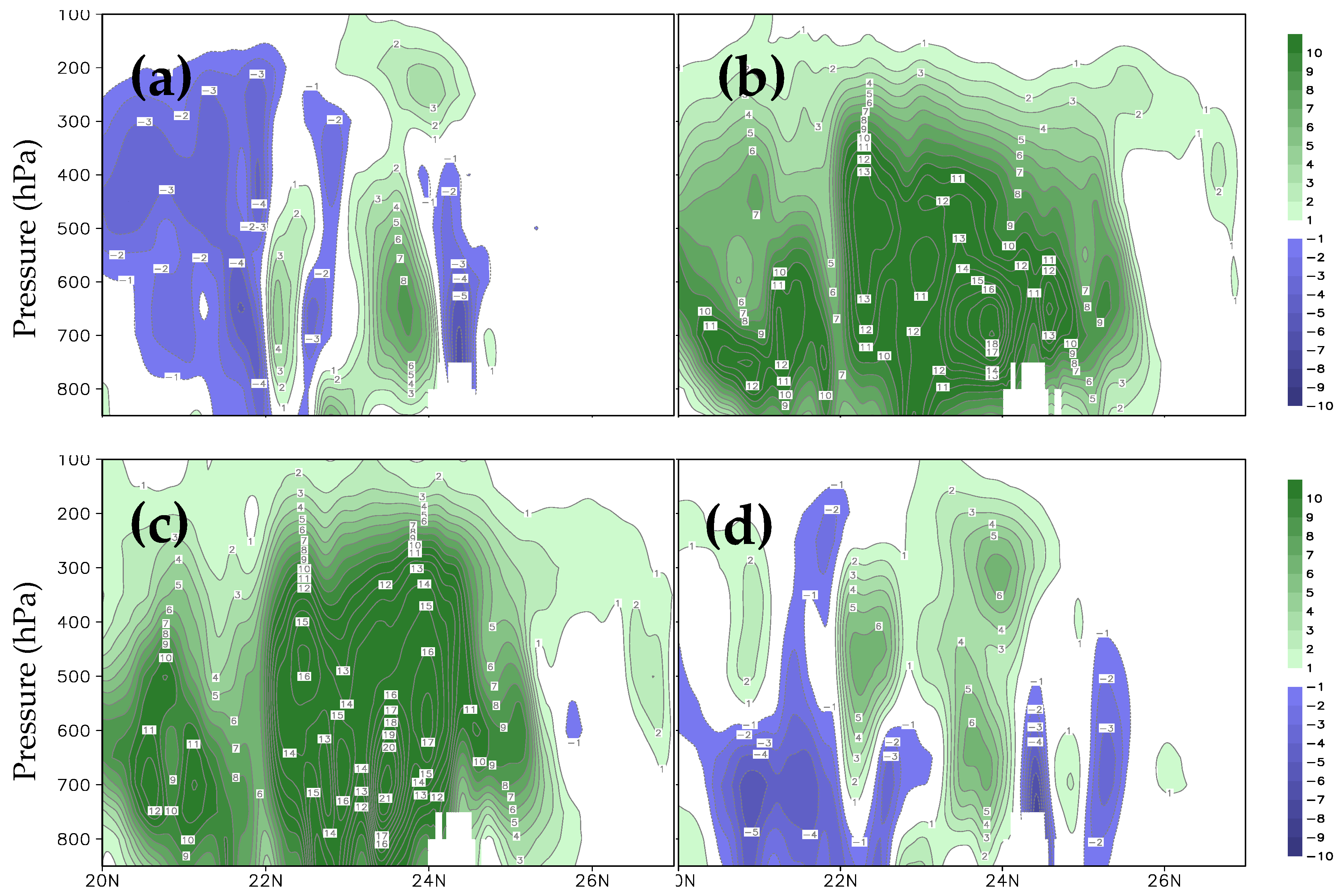
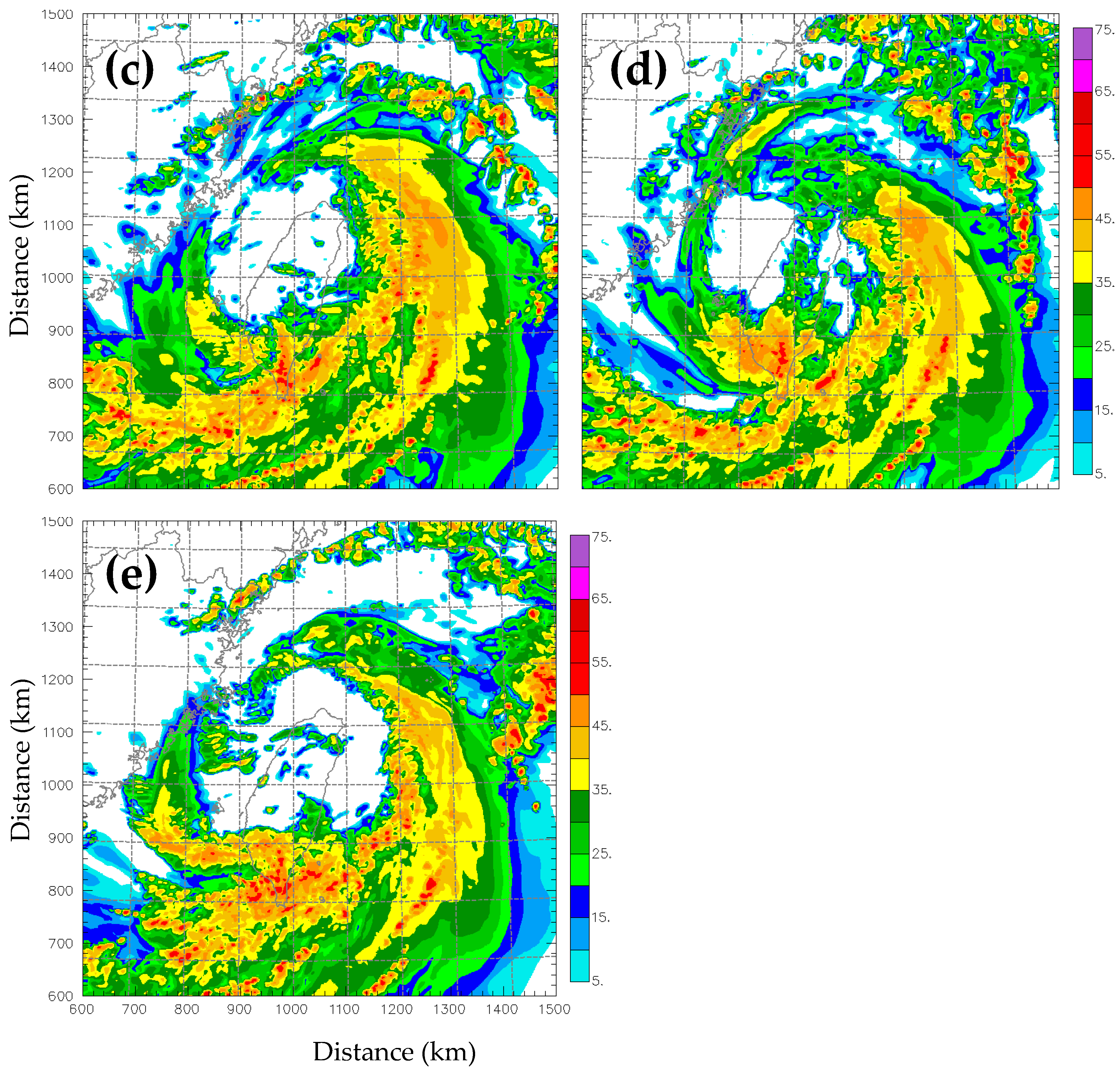
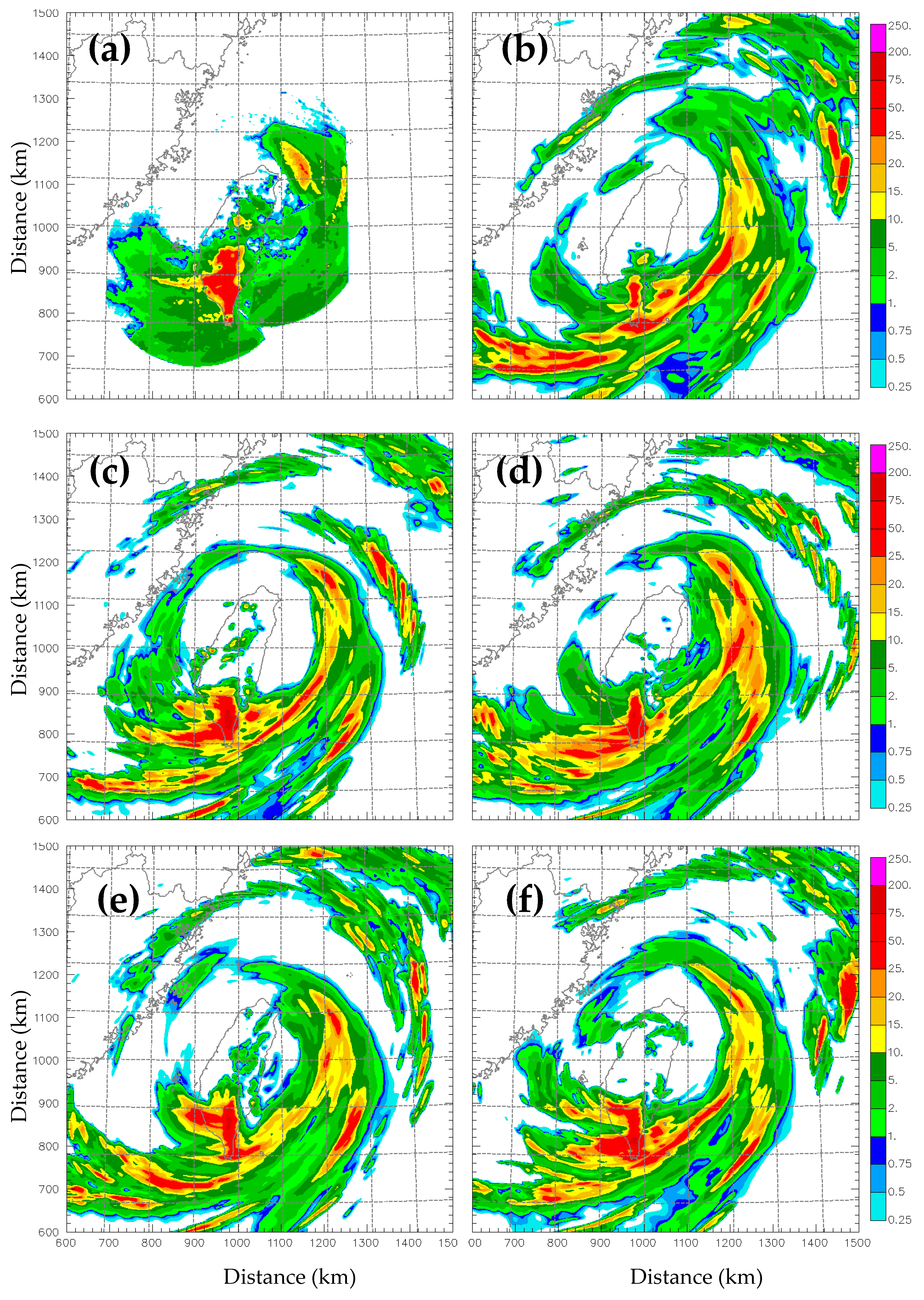
5.3. Hourly Precipitation Forecast
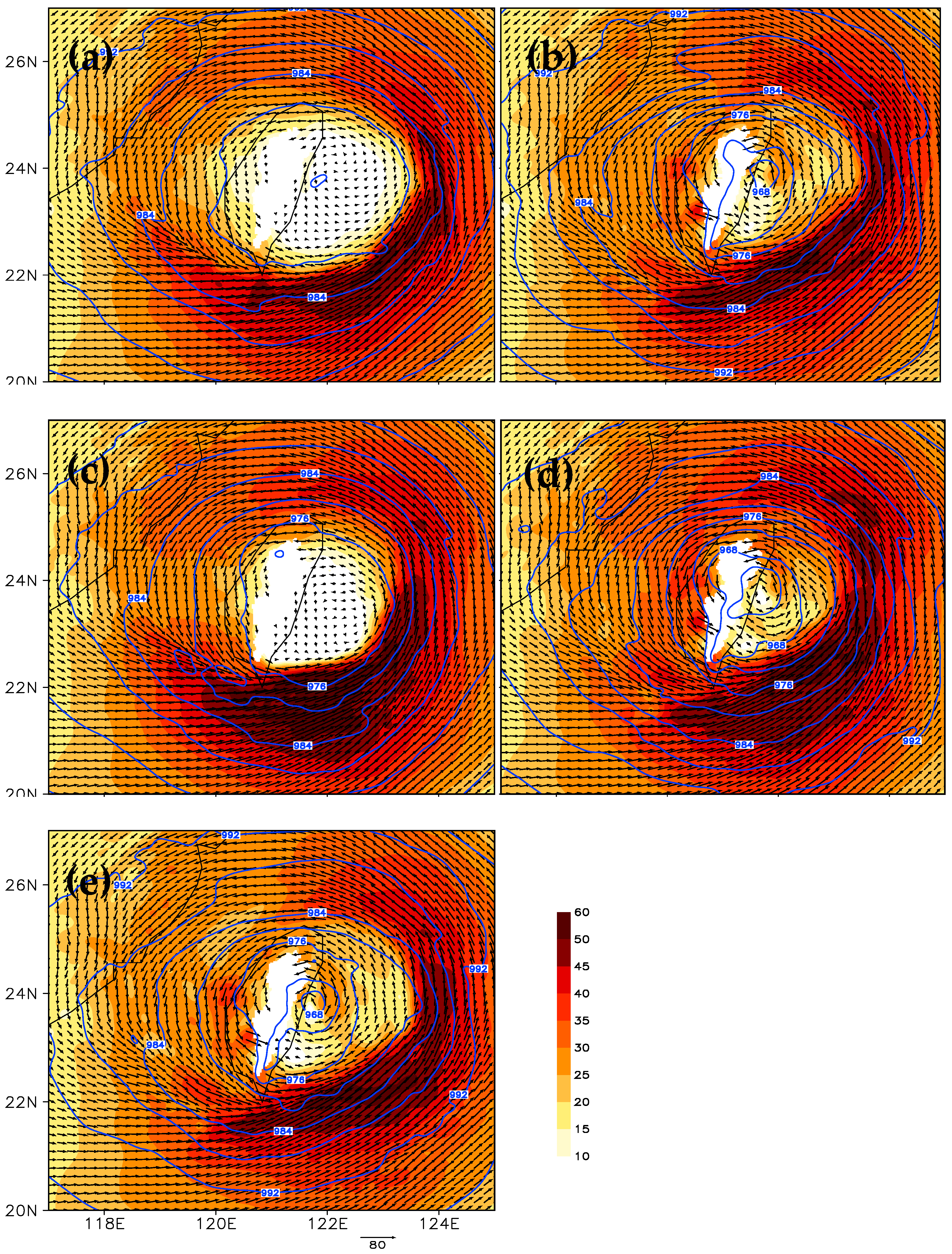
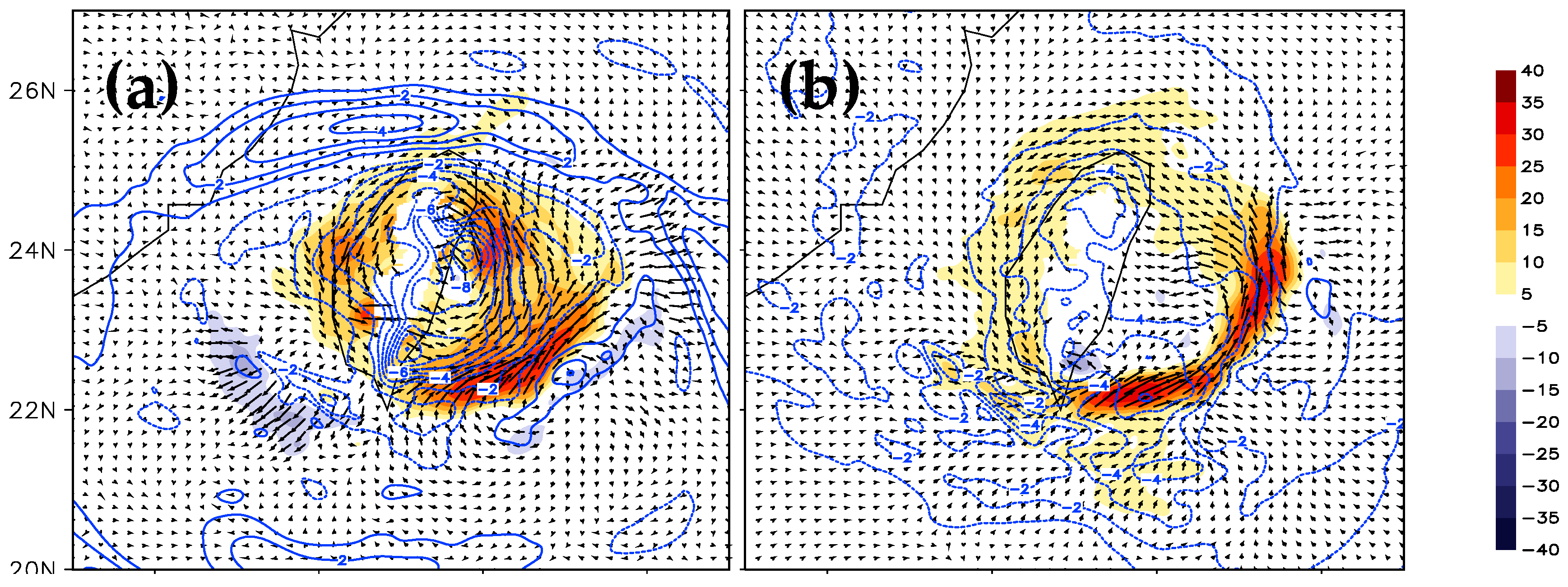
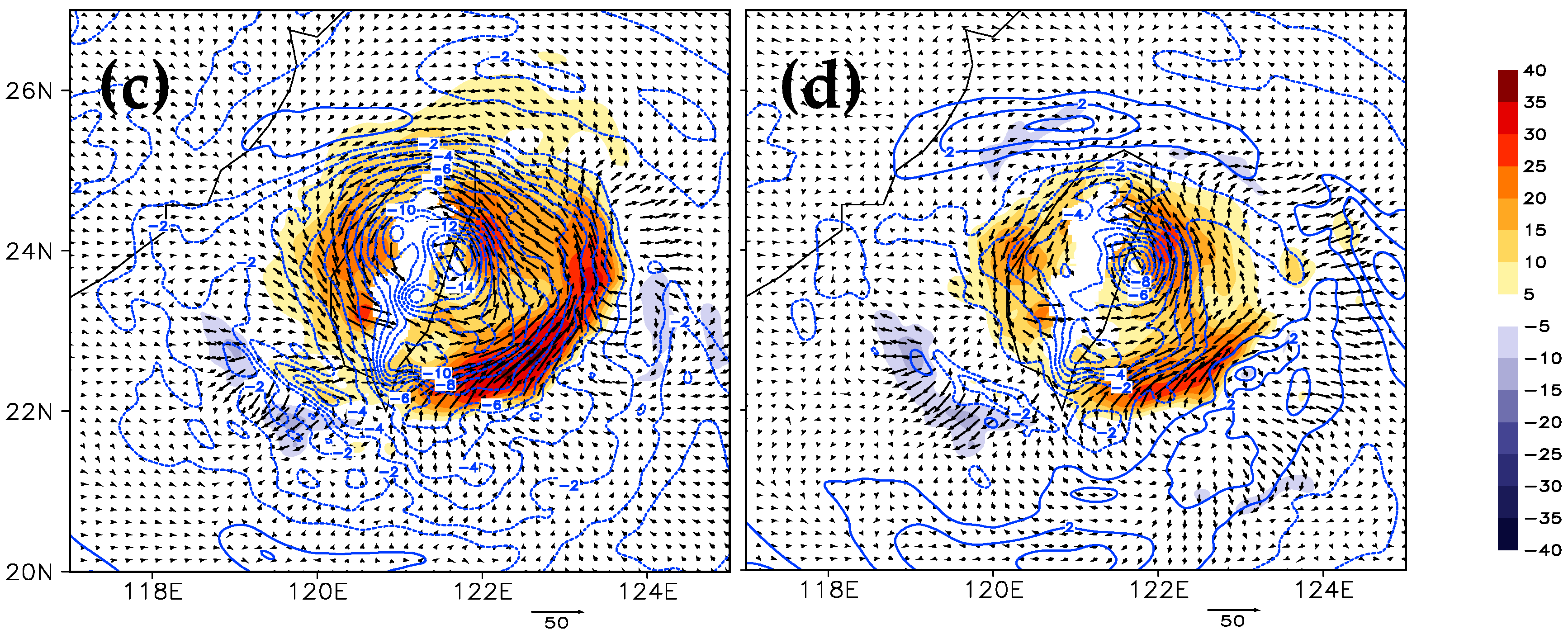
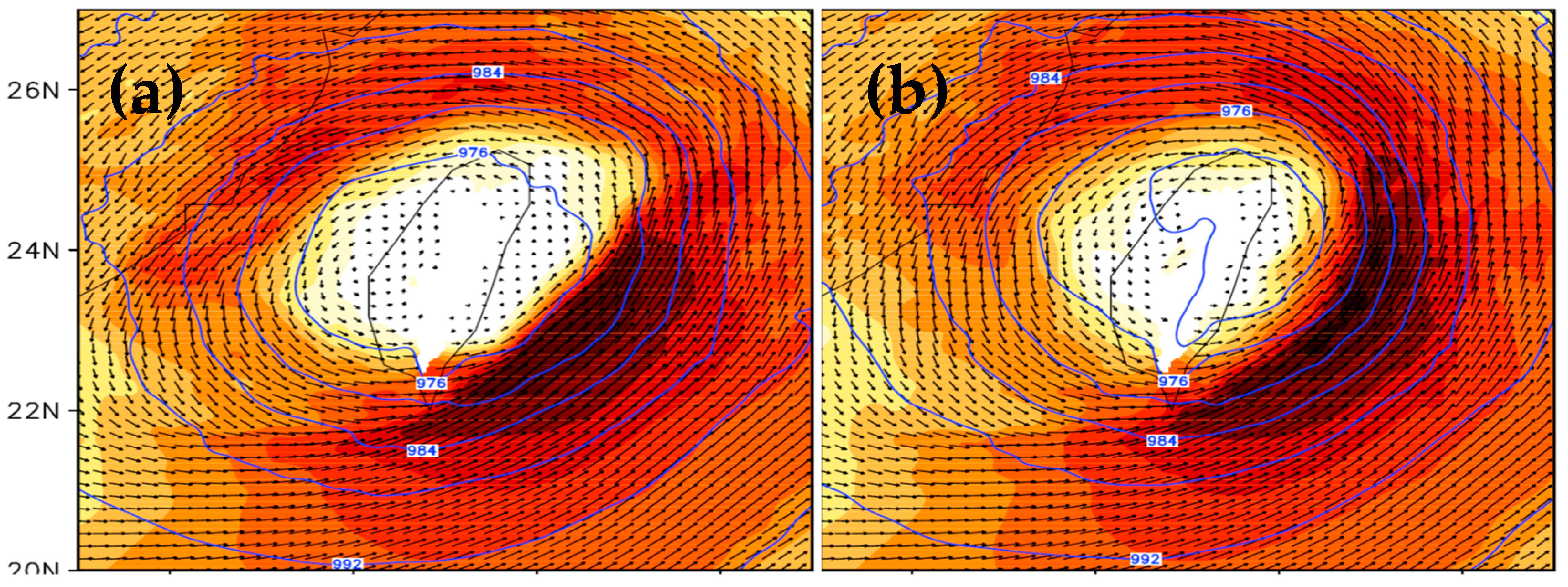
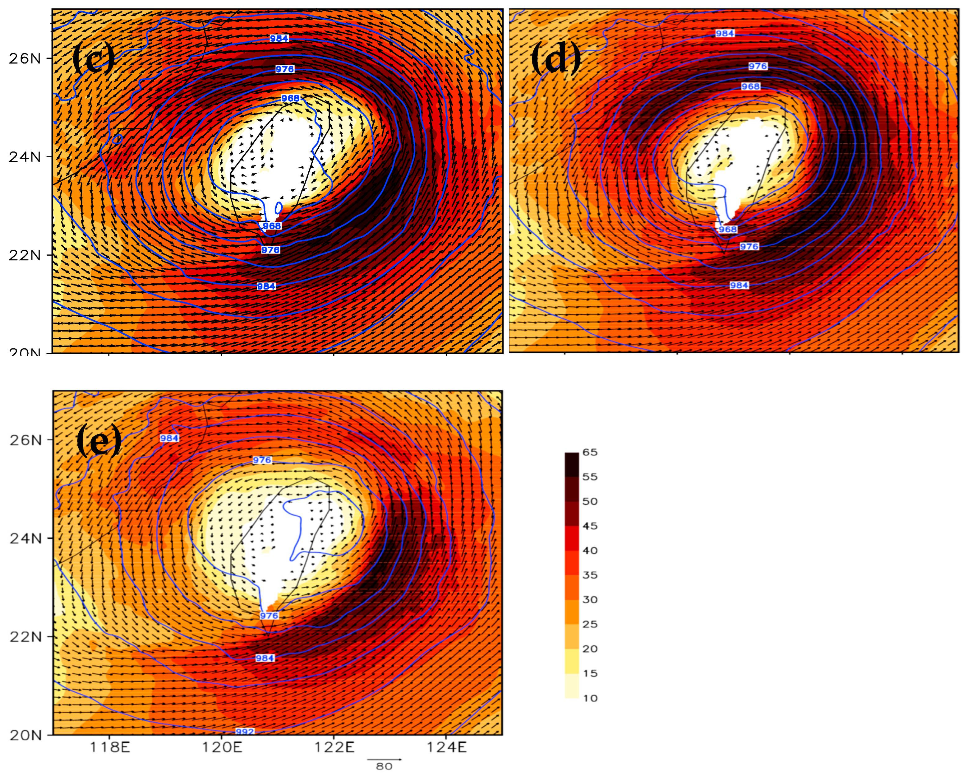
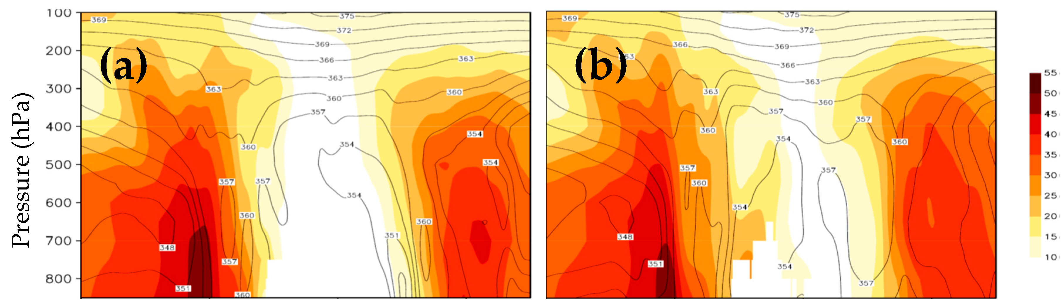
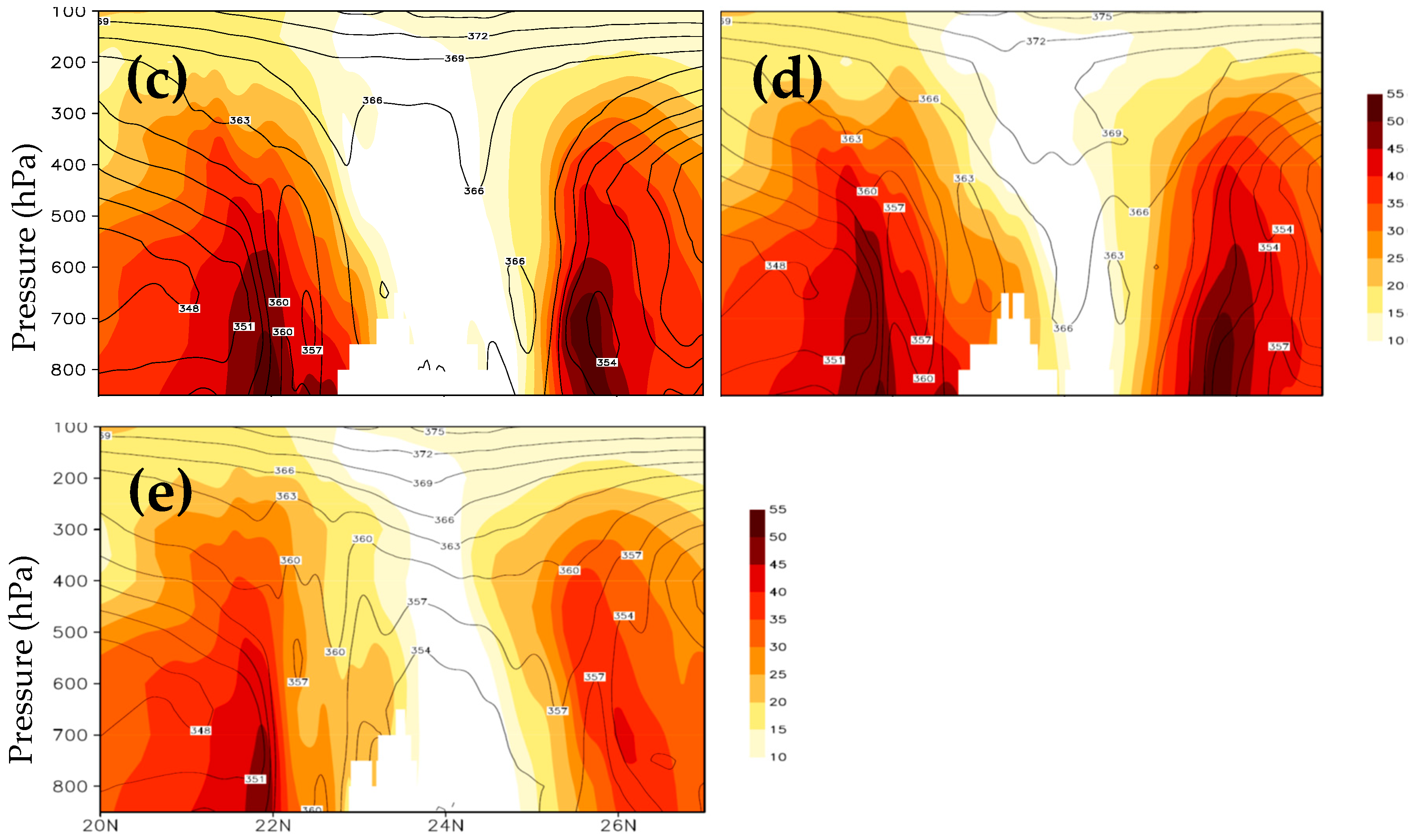
5.4. Hurricane Structure
5.5. Typhoon Track and Intensity
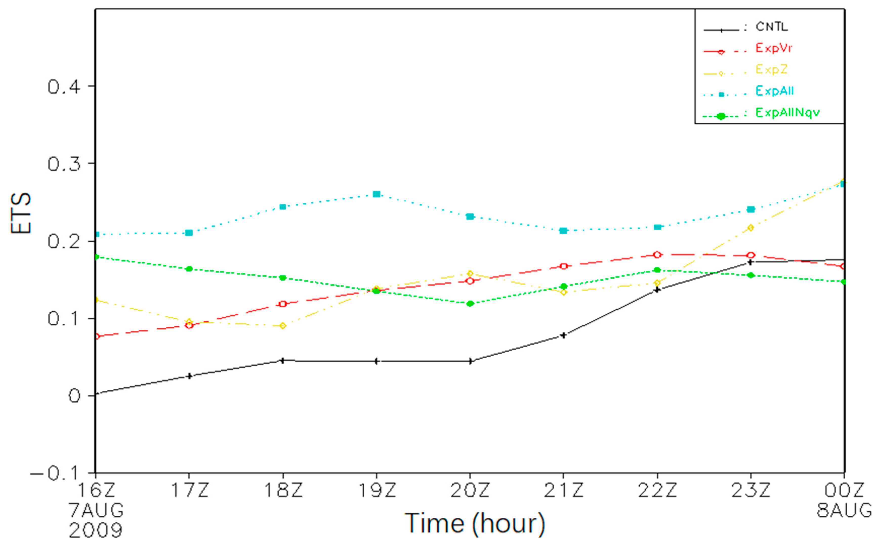
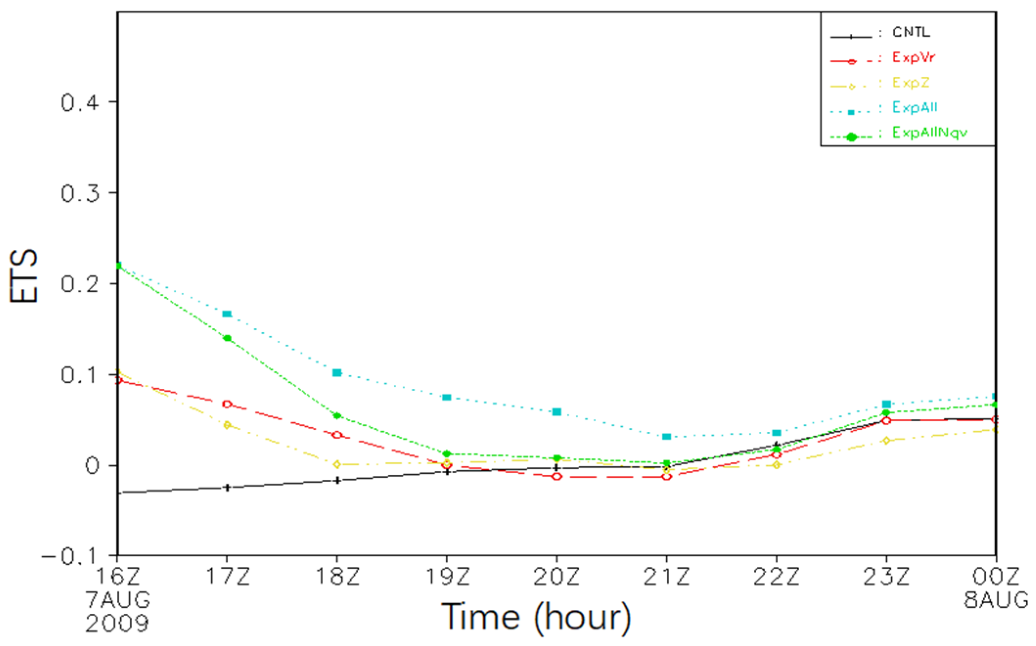
5.6. Intensity-Scale Skill Score
6. Summary and Discussion
- Simulations incorporating radar data assimilation enhanced the representation of the typhoon vortex structure both at the conclusion of the assimilation time window and throughout the following 9 h forecast period. The typhoon intensity and track forecasts also benefited from the assimilation.
- The specific humidity adjustment in the cloud analysis procedure retrieved more moisture of the hurricane vortex in the assimilation time window. This produced more reasonable responses in other dynamic and thermodynamic variables. The composite reflectivity and rainbands were also favorably reorganized and appear more realistic due to tuning specific humidity.
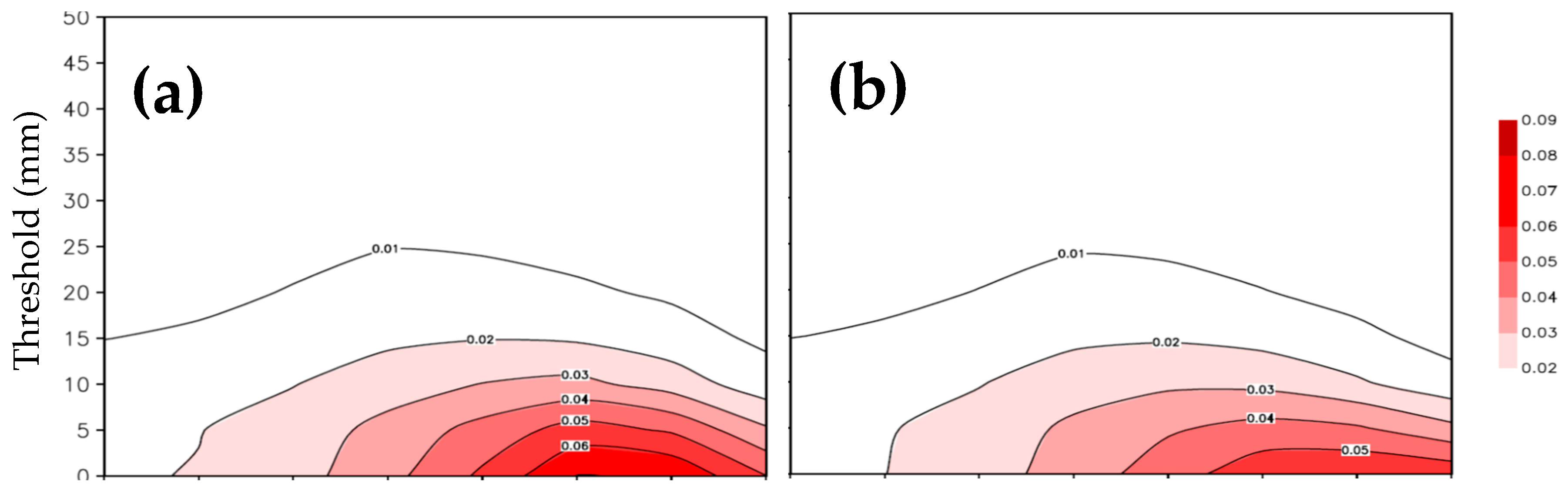
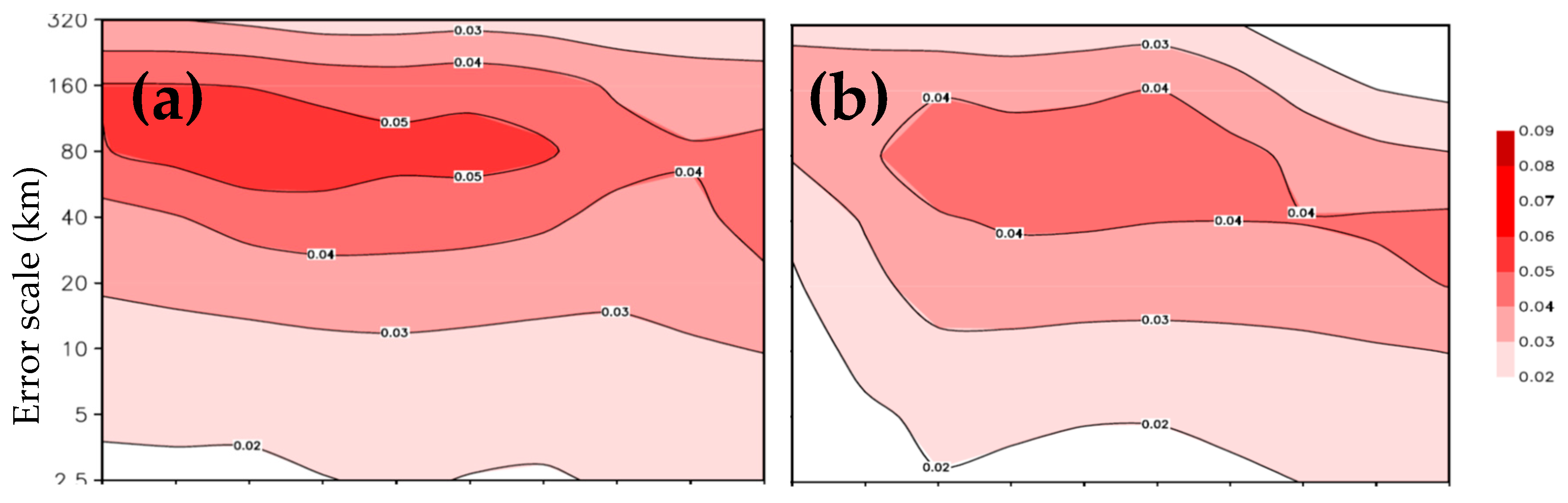
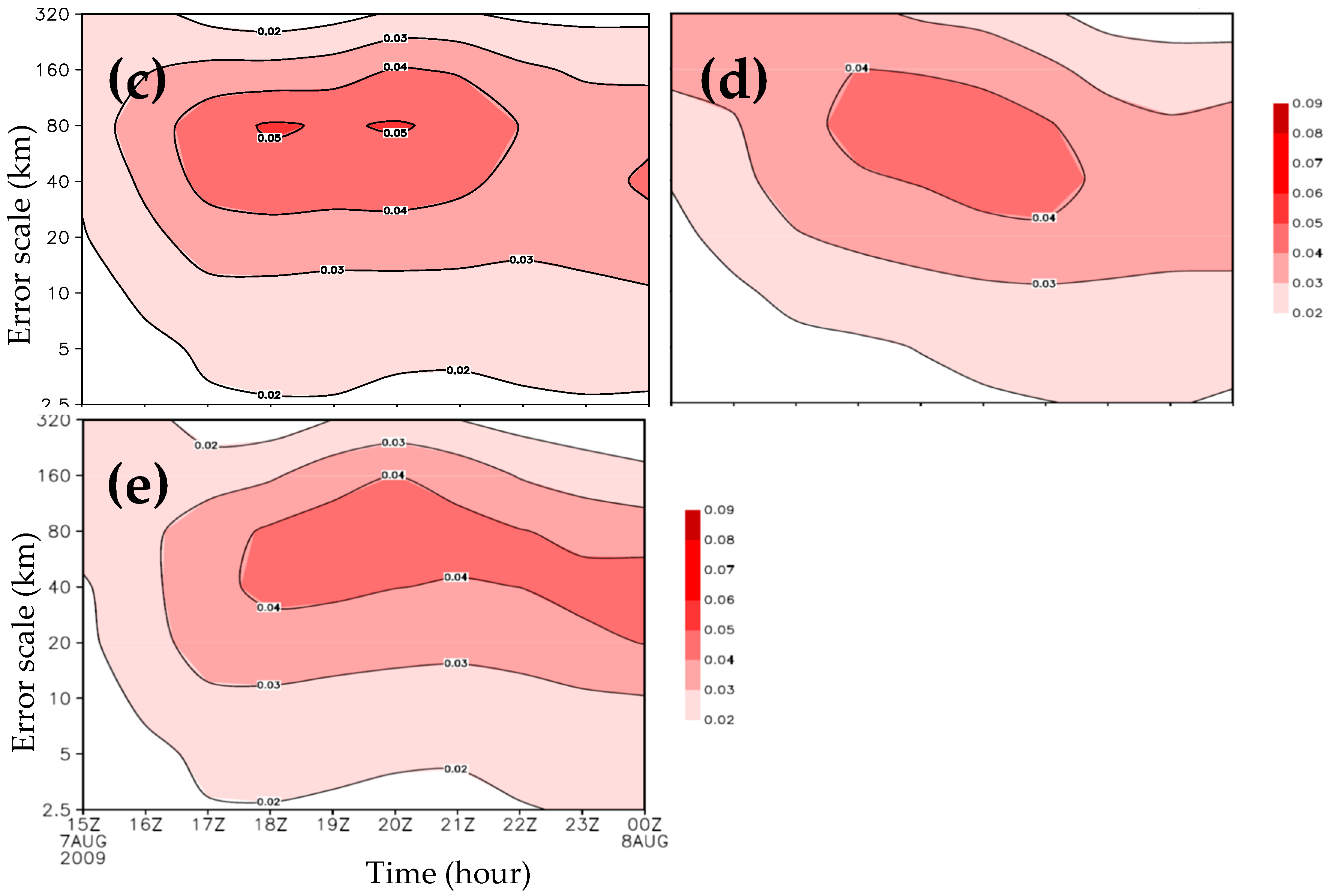
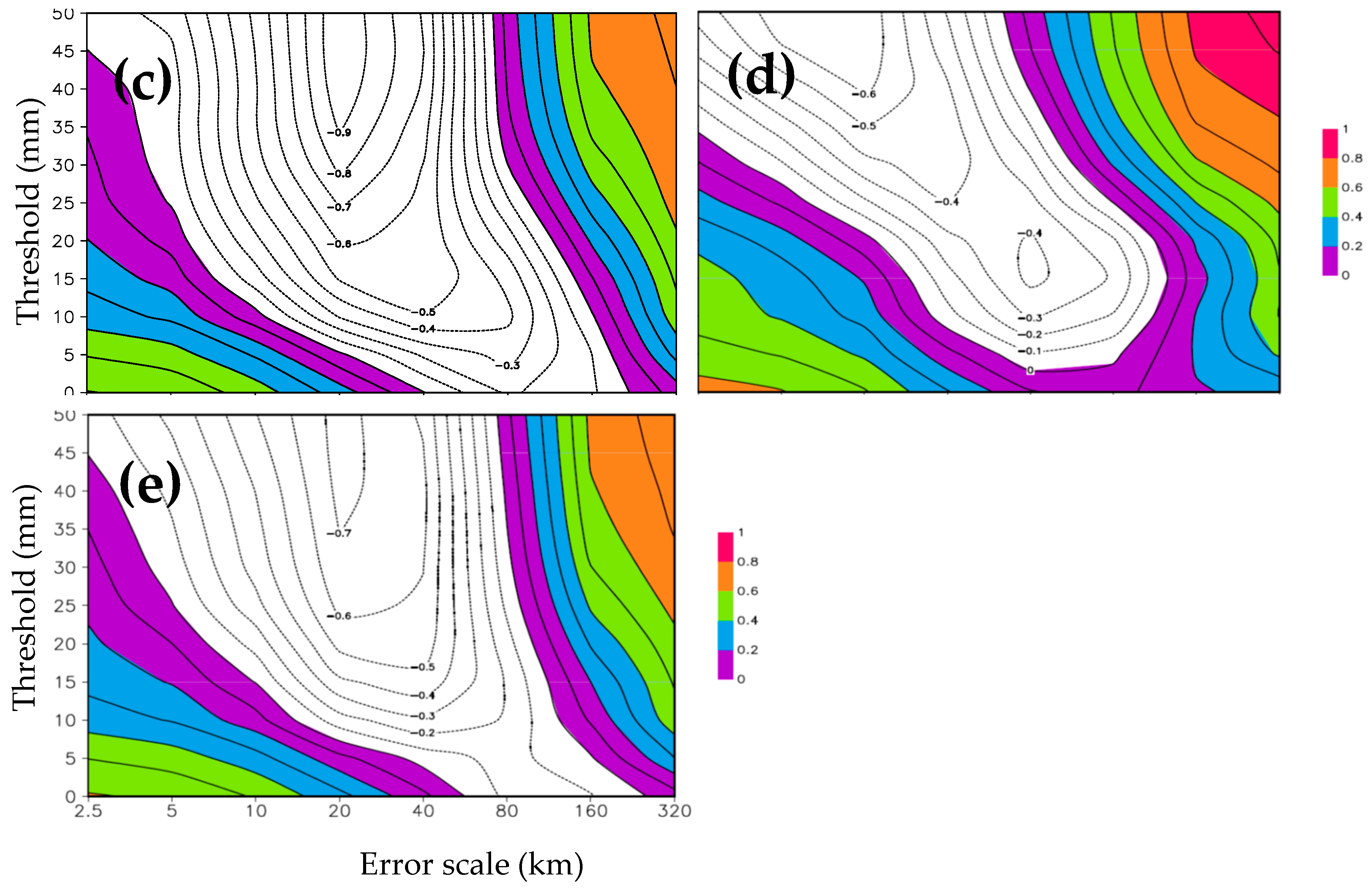
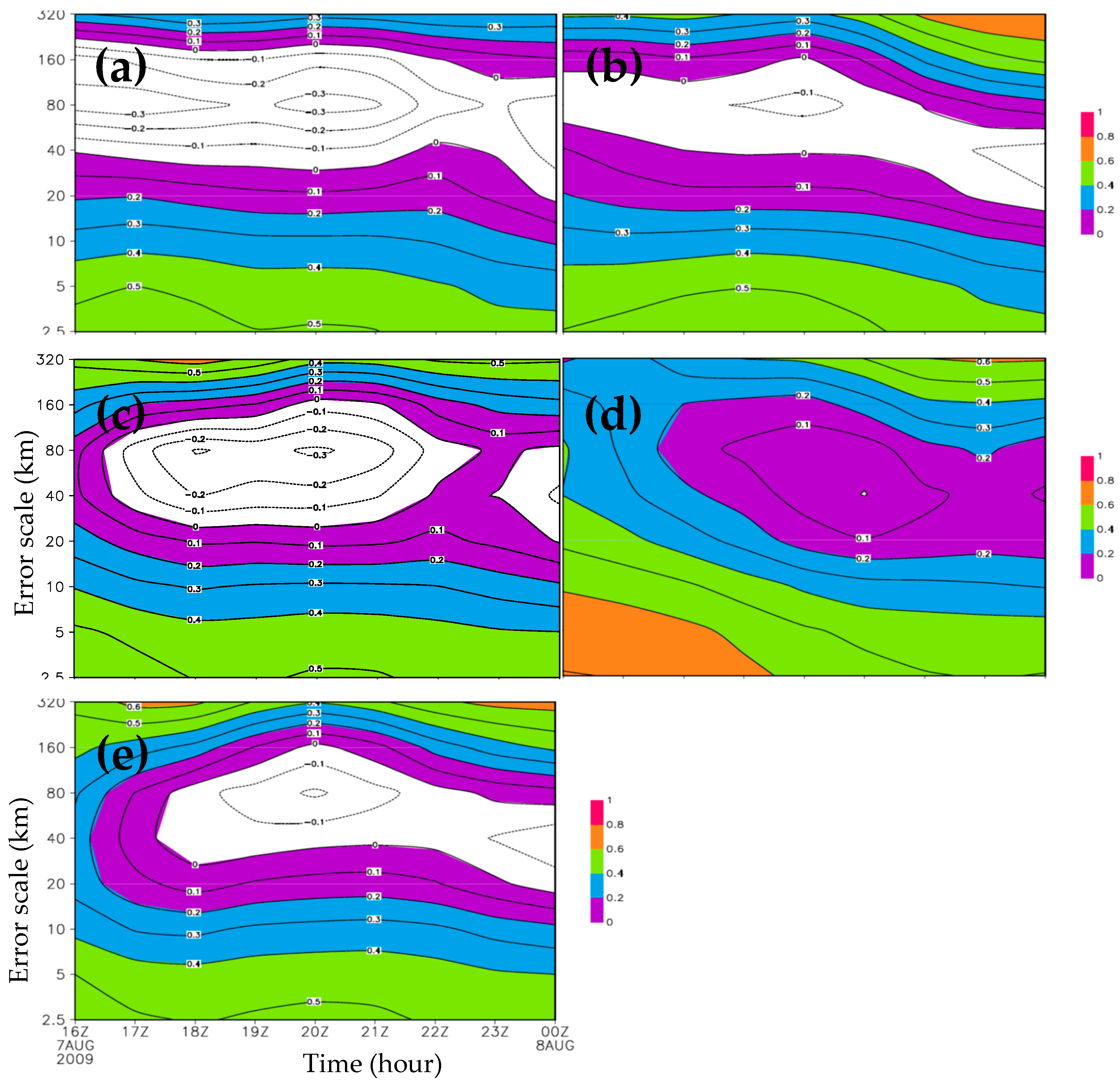
- The assimilation improved the neighborhood-based ETS for the smaller spatial scales at the stage of Morakot landing, and for the larger scales of forecast error at the stage of Morakot going inland. The assimilation with the specific humidity adjustment (ExpAll) also demonstrated skillful forecasting in precipitation forecasting for the spatial forecast-error scales of 30–160 km for which CNTL, ExpVr, ExpZ, and ExpAllNqv proved unskillful.
Author Contributions
Funding
Institutional Review Board Statement
Informed Consent Statement
Data Availability Statement
Acknowledgments
Conflicts of Interest
Abbreviations
| ARPS | Advanced Region Prediction System |
| NCEP | National Centers for Environmental Prediction |
| GFS | Global Forecast System |
| COAMPS | Coupled Ocean Atmosphere Mesoscale Prediction System |
| ADR | Doppler Radar |
| WRF | Weather Research and Forecasting |
| ETS | Equivalent Threat Score |
| IS | Intensity-Scale |
| 3DVAR | 3-Dimensional Variation |
| JMA | Japan Meteorological Agency |
| MSWP | Maximum Surface Wind Speed |
| CCA | Complex Cloud Analysis |
| ADAS | ARPS Data Analysis System |
| LAPS | Local Analysis and Prediction System |
| CNTL | Control Run |
| CSLP | Central Sea Level Pressure |
| SLP | Sea Level Pressure |
References
- Aberson, S. Targeted observations to improve operational tropical cyclone track forecast guidance. Mon. Wea. Rev. 2003, 131, 1613–1628. [Google Scholar] [CrossRef]
- Elsberry, R.L. Achievement of USWRP hurricane landfall research goal. Bull. Am. Meteor. Soc. 2005, 86, 643–645. [Google Scholar] [CrossRef]
- Xiao, Q.; Sun, J. Multiple-radar data assimilation and short-range quantitative precipitation forecasting of a squall line observed during IHOP_2002. Mon. Wea. Rev. 2007, 135, 3381–3404. [Google Scholar] [CrossRef]
- Hsin-Hung, L.; Lin, P.L.; Xiao, Q.; Kuo, Y.H. Effect of Doppler Radial Velocity Data Assimilation on the Simulation of a Typhoon Approaching Taiwan: A Case Study of Typhoon Aere (2004). Terr. Atmos. Ocean. Sci. 2011, 22, 3. [Google Scholar]
- Zhao, Q.; Jin, Y. High-resolution radar data assimilation for Hurricane Isabel (2003) at landfall. Bull. Am. Meteor. Soc. 2008, 89, 1355–1372. [Google Scholar] [CrossRef]
- Houze, R.A., Jr.; Chen, S.S.; Lee, W.C.; Rogers, R.F.; Moore, J.A.; Stossmeister, G.J.; Bell, M.M.; Cetrone, J.; Zhao, W.; Brodzik, S.R. The hurricane rainband and intensity change experiment—Observations and modeling of Hurricanes Katrina, Ophelia, and Rita. Bull. Am. Meteor. Soc. 2006, 87, 1503–1521. [Google Scholar] [CrossRef]
- Zhao, K.; Xue, M. Assimilation of coastal Doppler radar data with the ARPS 3DVAR and cloud analysis for the prediction of Hurricane Ike (2008). Geophys. Res. Lett. 2009, 36, L12803. [Google Scholar] [CrossRef]
- Marks, F.D. State of the science: Radar view of tropical cyclones. Meteorol. Monogr. 2003, 30, 33–74. [Google Scholar] [CrossRef]
- Xiao, Q.; Zhang, X.; Davis, C.; Tuttle, J.; Holland, G.; Fitzpatrick, P.J. Experiments of Hurricane Initialization with Airborne Doppler Radar Data for the Advanced Research Hurricane WRF (AHW). Model. Mon. Wea. Rev. 2009, 137, 2758–2777. [Google Scholar] [CrossRef]
- Pu, Z.; Li, X.; Sun, J. Impact of Airborne Doppler Radar Data Assimilation on the Numerical Simulation of Intensity Changes of Hurricane Dennis near a Landfall. J. Atmos. Sci. 2009, 66, 3351–3365. [Google Scholar] [CrossRef]
- Yau, M.K.; Liu, Y.; Zhang, D.L.; Chen, Y. A multiscale numerical study of Hurricane Andrew (1992). Part VI: Smallscale inner-core structures and wind streaks. Mon. Wea. Rev. 2004, 132, 1410–1433. [Google Scholar] [CrossRef]
- Braun, S.A.; Montgomery, M.T.; Pu, Z. High-resolution simulation of Hurricane Bonnie (1998). Part I: The organization of eyewall vertical motion. J. Atmos. Sci. 2006, 63, 19–42. [Google Scholar] [CrossRef]
- Gilleland, E.; Ahijevych, D.; Brown, B.G.; Casati, B.; Ebert, E.E. Intercomparison of Spatial Forecast Verification Methods. Wea. Forecast. 2009, 24, 1416–1430. [Google Scholar] [CrossRef]
- Clark, A.J.; Gallus, W.A., Jr.; Weisman, M.L. Neighborhood-Based Verification of Precipitation Forecasts from Convection-Allowing NCAR WRF Model Simulations and the Operational NAM. Wea. Forecast. 2010, 25, 1495–1509. [Google Scholar] [CrossRef]
- Casati, B.; Ross, G.; Stephenson, D.B. A new intensityscale approach for the verification of spatial precipitation forecasts. Meteor. Appl. 2004, 11, 141–154. [Google Scholar] [CrossRef]
- Casati, B. New Developments of the Intensity-Scale Technique within the Spatial Verification Methods Intercomparison Project. Weather. Forecast. 2010, 25, 113–143. [Google Scholar] [CrossRef]
- Wilks, D.S. Forecast Verification; Elsevier BV: Amsterdam, The Netherlands, 2019. [Google Scholar]
- Ebert, E.E. Neighborhood verification: A strategy for rewarding close forecasts. Wea. Forecast. 2009, 24, 1498–1510. [Google Scholar] [CrossRef]
- Wang, M.; Xue, M.; Zhao, K. The Impact of T-TREC-retrieved Wind and Radial Velocity Data Assimilation using EnKF and Effects of Assimilation Window on the Analysis and Prediction of Typhoon Jangmi (2008): T-TREC-retrieved Winds EnKF Assimilation. J. Geophys. Res. Atmos. 2016, 121, 259–277. [Google Scholar] [CrossRef]
- Gao, J.; Xue, M.; Brewster, K.; Droegemeier, K.K. A three-dimensional variational data analysis method with recursive filter for Doppler radars. J. Atmos. Ocean. Technol. 2004, 21, 457–469. [Google Scholar] [CrossRef]
- Xue, M.; Droegemeier, K.K.; Wong, V.; Shapiro, A.; Brewster, K.; Carr, F.; Weber, D.; Liu, Y.; Wang, D.-H. The dvanced Regional Prediction System (ARPS)—A multiscale nonhydrostatic atmospheric simulation and prediction tool. Part II: Model physics and applications, Meteorol. Atmos. Phys. 2001, 76, 143–165. [Google Scholar] [CrossRef]
- Xue, M.; Wang, D.-H.; Gao, J.-D.; Brewster, K.; Droegemeier, K.K. The Advanced Regional Prediction System (ARPS), storm-scale numerical weather prediction and data assimilation. Meteorol. Atmos. Phys. 2003, 82, 139–170. [Google Scholar] [CrossRef]
- Zhang, J. Moisture Diabatic Initialization Based on Radar Satellite Observation. Ph D. Thesis, University of Oklahoma, Norman, Oklahoma, 1999; 194p. [Google Scholar]
- Smith, P.L., Jr.; Myers, C.G.; Orville, H.D. Radar reflectivity factor calculations in numerical cloud models using bulk parameterization of precipitation. J. Appl. Meteor. 1975, 14, 1156–1165. [Google Scholar] [CrossRef]
- Zhuang, Z.; Jiang, Y.; Tian, W.; Huang, L.; Li, X.; Deng, L. Hourly Rapid Updating Assimilation Forecast System of CMA-MESO and Preliminary Analysis of Short-term Forecasting Effect. Chin. J. Atmos. Sci. 2023, 47, 925–942. (In Chinese) [Google Scholar]
- Ming, H.; Xue, M.; Gao, J.; Brewster, K. 3DVAR and Cloud Analysis with WSR-88D Level-II Data for the Prediction of the Fort Worth Texas Tornadic Thunderstorms Part II: Impact of Radial Velocity Analysis via 3DVAR. Mon. Wea. Rev. 2006, 134, 699–721. [Google Scholar]
- Ming, H.; Xue, M.; Brewster, K. 3DVAR and Cloud Analysis with WSR-88D Level-II Data for the Prediction of the Fort Worth, Texas, Tornadic Thunderstorms. Part I: Cloud Analysis and Its Impact. Mon. Wea. Rev. 2006, 134, 675–698. [Google Scholar]


Disclaimer/Publisher’s Note: The statements, opinions and data contained in all publications are solely those of the individual author(s) and contributor(s) and not of MDPI and/or the editor(s). MDPI and/or the editor(s) disclaim responsibility for any injury to people or property resulting from any ideas, methods, instructions or products referred to in the content. |
© 2025 by the authors. Licensee MDPI, Basel, Switzerland. This article is an open access article distributed under the terms and conditions of the Creative Commons Attribution (CC BY) license (https://creativecommons.org/licenses/by/4.0/).
Share and Cite
Ran, L.; Wu, C. Impact of Radar Data Assimilation on the Simulation of Typhoon Morakot. Atmosphere 2025, 16, 910. https://doi.org/10.3390/atmos16080910
Ran L, Wu C. Impact of Radar Data Assimilation on the Simulation of Typhoon Morakot. Atmosphere. 2025; 16(8):910. https://doi.org/10.3390/atmos16080910
Chicago/Turabian StyleRan, Lingkun, and Cangrui Wu. 2025. "Impact of Radar Data Assimilation on the Simulation of Typhoon Morakot" Atmosphere 16, no. 8: 910. https://doi.org/10.3390/atmos16080910
APA StyleRan, L., & Wu, C. (2025). Impact of Radar Data Assimilation on the Simulation of Typhoon Morakot. Atmosphere, 16(8), 910. https://doi.org/10.3390/atmos16080910