Article

Spatiotemporal Characteristics and Rainfall Thresholds of Geological Landslide Disasters in ASEAN Countries

1
Guangxi Institute of Meteorological Sciences, Nanning 530022, China
2
School of Geography and Planning, Nanning Normal University, Nanning 530001, China
3
Wuzhou Meteorological Bureau, Wuzhou 543001, China
*
Author to whom correspondence should be addressed.
Atmosphere 2024, 15(5), 599; https://doi.org/10.3390/atmos15050599
Submission received: 11 April 2024 / Revised: 9 May 2024 / Accepted: 11 May 2024 / Published: 14 May 2024
(This article belongs to the Section Meteorology)

Abstract

:
Drawing upon a comprehensive global database of landslides and utilizing high-resolution IMERG satellite precipitation data, this study investigates the spatial and temporal variations of landslide occurrences across the member states of the Association of Southeast Asian Nations (ASEAN). This study constructs a region-specific, graded warning system by formulating an average effective intensity–duration (ID) rainfall threshold curve for each ASEAN member. Examination of 1747 landslide events spanning from 2006 to 2018 illustrates a significant association between the frequency of landslides in ASEAN regions and the latitudinal movement of local precipitation bands. Incidences of landslides hit their lowest in March and April, while a surge is observed from October to January, correlating with the highest mortality rates. Geographical hotspots for landslide activity, characterized by substantial annual rainfall and constrained landmasses, include the Philippine archipelago, Indonesia’s Java Island, and the Malay Peninsula, each experiencing an average of over 2.5 landslides annually. Fatalities accompany approximately 41.4% of ASEAN landslide events, with the Philippines and Indonesia registering the most substantial numbers. Myanmar stands out for the proportion of large-scale landslide incidents, with an average casualty rate of 10.89 deaths per landslide, significantly surpassing other countries in the region. The ID rainfall threshold curves indicate that the Philippines experienced the highest precipitation levels before landslide initiation, whereas Myanmar has the threshold set at a considerably lower level.

1. Introduction

The Association of Southeast Asian Nations (ASEAN), including the Philippines, Indonesia, Malaysia, Vietnam, Thailand, Myanmar, Brunei, Laos, Cambodia, and Singapore, are particularly susceptible to geological hazards, placing them among the most disaster-prone regions worldwide, attributed to their complex landscapes and climatic conditions [1]. Geological calamities, particularly landslides, are a recurrent issue, causing substantial human and financial losses and impeding socio-economic progress within ASEAN territories. The rising impact of such disasters has garnered increasing scholarly attention over recent years [2]. The United Nations Office for Risk Reduction emphasized the urgency for ASEAN countries to advance their landslide disaster risk assessments to adequately prepare for the required adaptations to climate change [3].
Rainfall amount and intensity are very important for landslides, with studies showing that over 90% of such incidents are precipitation induced [4,5]. Prolonged or heavy rainfall can saturate soil, reducing its strength and cohesion, and making it more prone to slope failure. However, intense rainfall events can directly contribute to landslides by causing rapid infiltration of water into the soil, leading to a sudden increase in pore water pressure. This rapid increase in water pressure can exceed the soil’s ability to dissipate the excess water, resulting in slope instability and potential landslide occurrence. Consequently, defining accurate rainfall thresholds is crucial for predicting landslides and issuing timely alerts. This has led to considerable research into the nexus between rainfall patterns and landslide occurrences, with a focus on identifying precise precipitation limits that trigger these events [6,7,8].
Scholars have pursued two principal methodologies to develop landslide rainfall threshold models: one based on hydrologic and geological parameters combined with finite element modeling [9] and the other utilizing empirical thresholds based on historical data of rainfall and landslide events [6,7,10]. Pioneering international studies by Caine [11] and others primarily dealt with empirical rainfall thresholds for landslides, investigating the interplay between critical rainfall intensity (I), duration (D), and the onset of shallow landslides and debris flows. Owing to its relative simplicity and robust accuracy, the empirical approach enjoys widespread application. Lin et al. [12] established a nuanced intensity–duration (ID) threshold curve tailored to the unique geological conditions of Cili County, China, taking into account soil thickness, slope angles, and landslide magnitude. Similarly, Xia et al. [13] conducted an ID model-based threshold analysis for landslides in Zhangjiajie City, China, considering various developmental patterns of rainfall-induced landslides. Dai et al. [14] developed distinct ID threshold curves for Huaping County, China, to account for landslides induced by both brief, heavy downpours and prolonged, low-intensity rainfall. And the four early warning levels at a regional scale for landslides have been built based on the rainfall–landslides relationship [15]. In Peninsular Malaysia, researchers formulated two separate rainfall threshold curves based on average and peak rainfall intensities [16]. Despite these advancements, empirical rainfall thresholds remain susceptible to the limitations of historical data and regional specificity, which often necessitate recalibration of the ID threshold models using local rainfall and landslide occurrences [10,17].
In the face of global warming, Southeast Asia is experiencing and anticipating an escalation in extreme precipitation events, which are exacerbating the frequency of landslide disasters [18,19]. These countries exhibit significant disparities in rainfall, topography, vegetation, and economic development levels. The ground-based rainfall data within the ASEAN countries is low quality with significant missing data [20]. Additionally, there is a dearth of comprehensive research and data on historical landslide events. Therefore, the present study elucidates the spatial-temporal dynamics of landslides in ASEAN countries and establishes a critical rainfall threshold model for the region. This model aims to serve as a scientific foundation and reference for the prediction and management of rainfall-triggered landslides in ASEAN nations.

2. Data and Methodology

2.1. Data

The database on landslide incidents within the ASEAN was sourced from the Global Landslide Catalog (GLC), accessible at https://gpm.nasa.gov/landslides/, accessed on 5 January 2022. The GLC compiles its data from various sources including online news outlets, disaster databases, and scholarly articles, focusing on landslides triggered by rainfall on a global scale. The dataset encapsulates 16 distinct data points for each event, such as the event’s date, the affected country, geographic coordinates, initiating factors, casualties, and the extent of the landslide [21]. The timeframe for the majority of the analyzed ASEAN landslide events spans from 2007 to 2018, with a limited number of incidents from 2006 also included. Records were carefully vetted to enhance data integrity, excluding any events without precise dates or location data, those without casualty figures, and events attributed to seismic or volcanic activity. After this rigorous selection process, 1747 comprehensive records were retained for analysis.
The ASEAN countries are generally underdeveloped and the meteorological stations are sparse distributed. Consequently, the available ground-based precipitation measurements are insufficient for the calculation of reliable landslide rainfall threshold models. The geography of the region, characterized by its intricate coastlines and the presence of numerous islands, particularly in nations such as the Philippines and Indonesia, are prone to landslides. And coarse-resolution precipitation data fail to capture the nuanced precipitation patterns specific to these areas, thus hindering the understanding of the precipitation–landslide relationship [21]. To address these limitations, this study employed the Integrated Multi-satellite Retrievals for GPM (IMERG) daily satellite precipitation product, which boasts a fine spatial resolution of 0.1° by 0.1° (~10 km), made available by the Global Precipitation Measurement mission. These satellite-derived data were leveraged to investigate the correlation between precipitation patterns and landslide occurrences.

2.2. Methods

2.2.1. Antecedent Effective Precipitation

When examining landslides triggered by rainfall, it is important to consider that not all preceding rainfall contributes to landslides. Factors such as infiltration, surface runoff, and evaporation reduce the effective amount of this antecedent rainfall [8]. Thus, total accumulated rainfall prior to a landslide does not provide an accurate measure of the precipitation’s impact. The term “antecedent effective precipitation” is used to denote the rainfall that genuinely impacts the likelihood of a landslide. This research adopts the widely recognized approach for calculating effective rainfall, as demonstrated in prior studies [8,13], using the equation:
R e = R 0 + i = 1 n k i R i
where R e signifies the antecedent effective rainfall (mm), R 0 is the rainfall recorded on the day of the landslide (mm), and R i refers to the daily rainfall during the n days leading up to the landslide (mm). The coefficient k represents the effective rainfall factor, which is generally accepted as 0.8, based on earlier research [13,22,23].

2.2.2. Intensity–Duration Model for Rainfall

In addition to antecedent effective rainfall, the occurrence of rainfall-induced landslides is also dependent on the intensity and duration of the rainfall. The model for correlating landslide occurrence with rainfall intensity and duration, as established by Caine [11], is extensively utilized in the study and prediction of landslides. The model is described by the following formula:
I = a D b
Within this model, I represents the rainfall intensity (mm/d), defined as the effective rainfall R e divided by the duration of rainfall D (days); the parameters a and b are statistically derived constants. This research defines the landslide day as the point of reference, with the preceding consecutive rainy days considered as the duration of rainfall. Accumulated rainfall prior to a landslide has been analyzed over various durations by distinct studies: 15 days [24], 4 days [22], 3 days [18], and 2 days [8]. Within this study, the 15-day cumulative rainfall period prior to a landslide yielded the most reliable results. To refine the impact assessment of rainfall on landslides, events with negligible rainfall (effective rainfall less than 5 mm) were omitted from the calculations for the intensity–duration (ID) threshold formula.
The ID threshold lines demarcate four levels of landslide risk: low, medium, high, and extremely high, predicated on the landslide occurrence probabilities. A probability of 10% or less is deemed low risk, 15% to 50% as medium risk, 50% to 90% as high risk, and above 90% as extremely high risk. Obtaining the threshold curves of 10% and 90% requires several procedures. Briefly, the difference (detaD) between the logarithm of the observed rainfall intensity log [I(D)] and the corresponding intensity value of the fit log [If(D)] is first calculated. Then, the probability density function of the detaD is determined through Kernel Density Estimation. Lastly, thresholds corresponding to different exceedance probabilities are defined based on the modeled (fitted) distribution of detaD. More detailed information can be found in [8,25]. Exceeding the 90% threshold line implies that the effective rainfall intensity has surpassed a critical level, correlating with a 90% likelihood of a landslide and categorizing the area as high-risk. The other risk levels are determined using analogous methods.
In addition to rainfall, the geological conditions of the bedrock also have a significant impact on landslides. However, due to the extensive scope of the study area covering ten countries in Southeast Asia and the limited availability of bedrock data, this paper did not investigate the geological conditions of the bedrock closely associated with landslides, focusing solely on the influence of rainfall on landslides.

3. Spatiotemporal Characteristics of Geological Landslides within ASEAN

The ASEAN nations occupy a strategic position at the intersection of the Indian Ocean and Pacific Basin, which bestows upon them a distinctive geographic setting. The landscape across the area is predominantly hilly and most locales experience a tropical climate marked by heat and significant precipitation. These characteristics, alongside the region’s dynamic geology, are a frequent cause of landslides [21]. Temporal patterns of landslide occurrences in the ASEAN region are illustrated in Figure 1, which reveals considerable seasonal and annual variability in landslide numbers and associated fatalities. The peak year for landslide activity is 2011, with 219 reported incidents. The span from October to January is notably landslide prone, with October alone representing 12.1% of the annual total at 257 events. The year 2009 witnessed the highest mortality, with 659 deaths, and the latter 6 months of the year, especially October and December, saw the bulk of fatalities, exceeding 1000 deaths each month due to landslides.
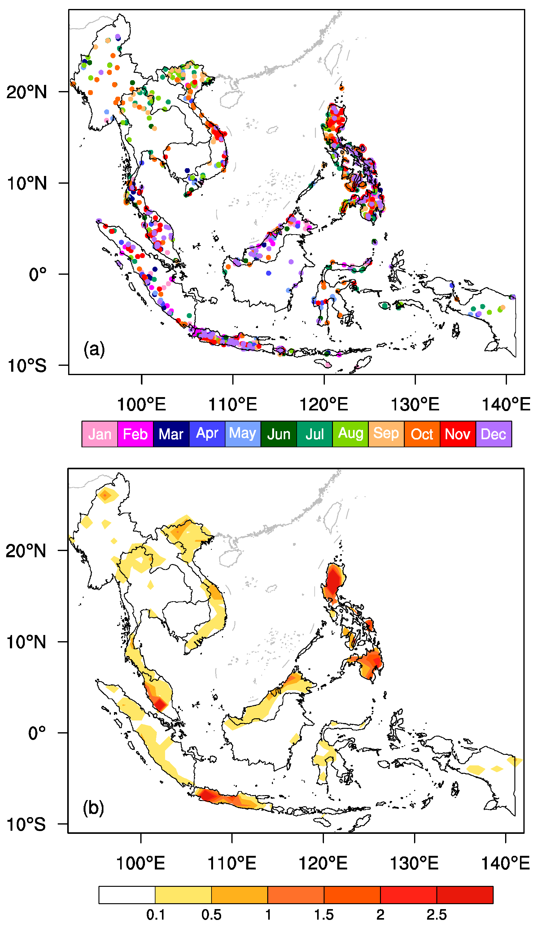
Spatial analysis (Figure 2a) indicates distinct temporal disparities in landslide events among the ASEAN countries. The maritime continent within 10° latitude typically sees landslides from November to February. The Philippine archipelago experiences landslides year-round, with the exception of spring. Conversely, the Indochina Peninsula north of 10° N primarily suffers landslides from June to October. These spatial trends are largely governed by the shifting patterns of regional rain belts. Moreover, regions with marked topographical diversity, like the northern territories of Myanmar, Vietnam, and Thailand, as well as certain coastal areas in central Vietnam, Malaysia, and the Philippines, are identified as areas with high landslide incidence. The islands of Sumatra and Java, which are coastal with varied topography, also face frequent landslides. According to the average annual frequency of landslides (Figure 2b), the Philippines, Java in Indonesia, and the Malay Peninsula display the highest occurrence rates, exceeding 2.5 events annually. These findings align with the landslide-prone zones identified by Froude and Petley [26] using the Global Fatal Landslide Database (https://www.arcgis.com/home/item.html?id=53cffc14c5a74a608503fb64a6f6c7e1 (accessed on 5 January 2022)). In stark contrast, the southern regions of Myanmar and Thailand, along with Cambodia, Laos, Kalimantan of Indonesia, and extensive parts of eastern Indonesia, have a lower incidence of landslides, which can be attributed to their lesser socio-economic development or lower population density.
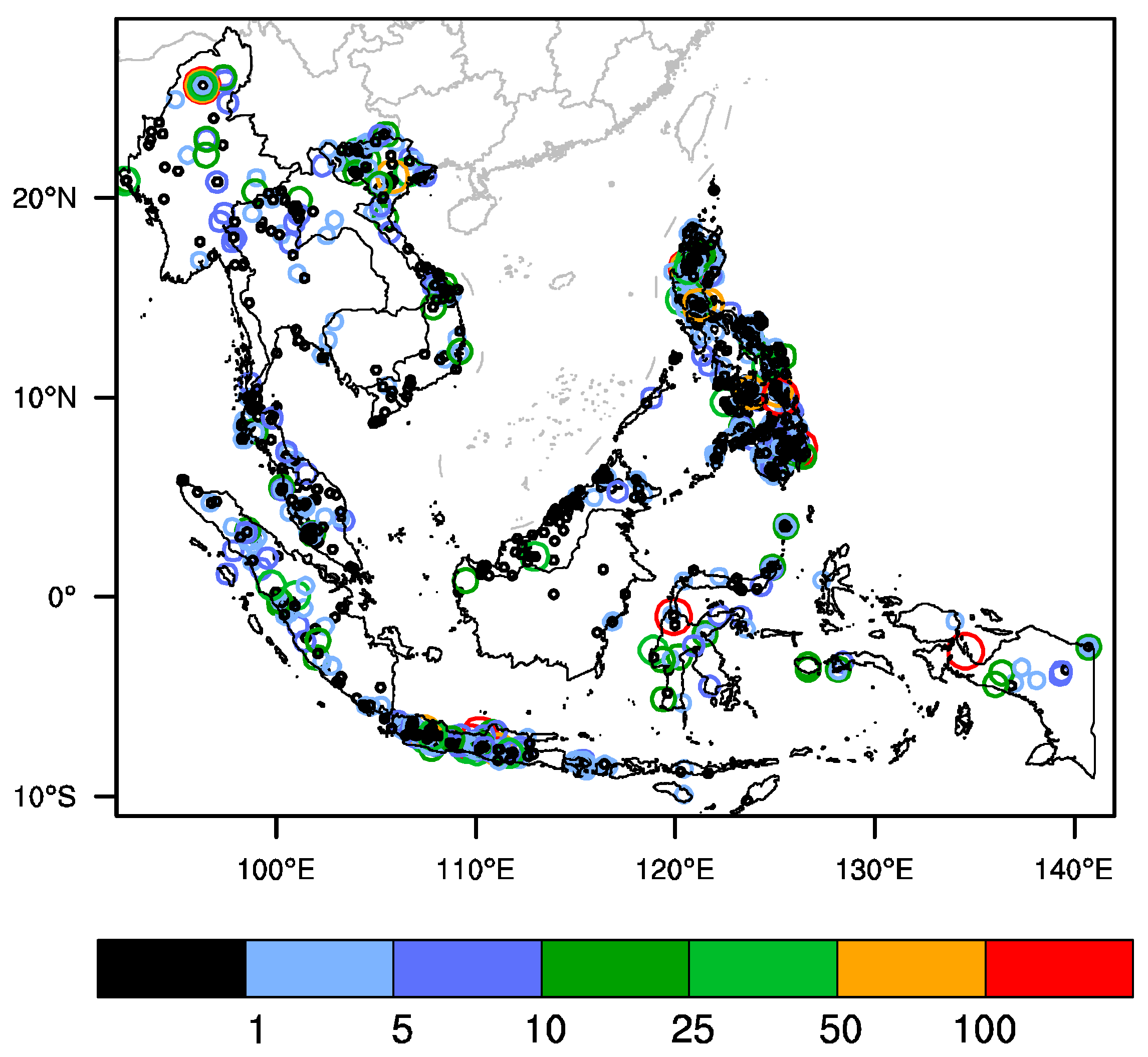
Landslides constitute a critical geological threat with frequently fatal outcomes. In the ASEAN region, between 2006 and 2018, there were 5305 recorded landslide-related deaths. Figure 3 illustrates the geographical distribution of these fatalities by individual landslide incidents within the specified timeframe. Although the majority of landslides, accounting for 58.6%, did not result in any fatalities, the remaining 41.4% were deadly. Among these fatal incidents, landslides causing 1 to 5 deaths constituted 25.8% of the total, while those resulting in 6 to 10 deaths made up 7.9%. Additionally, events with more than 10 fatalities accounted for 7.7% of the overall occurrences. The most devastating individual landslide occurred on 4 October 2010, in Wandama Bay County, West Papua, Indonesia (http://www.rttnews.com/Content/GeneralNews.aspx?Id=1436592&SM=1 (accessed on 5 January 2022)), triggered by heavy rainfall, claiming 145 lives—the highest death toll for a single landslide during the period under study. The deadliest landslide, triggered by tropical cyclone “Bopha” on 4 December 2012, in New Bataan, Philippines, resulted in 430 fatalities. Geographically, Indonesia, the Philippines, and the northern Indochina Peninsula emerge as high-risk zones for fatal landslides, with these areas frequently reporting incidents with ten or more deaths.
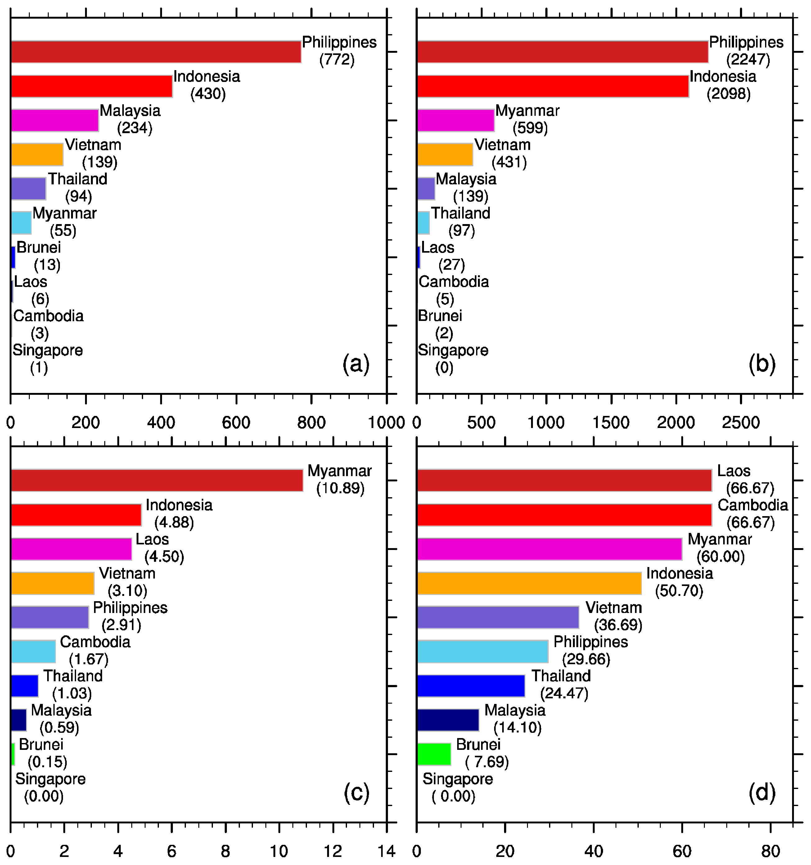
Figure 4 presents a comprehensive overview of landslide occurrences across ASEAN nations. The Philippines leads with 772 recorded landslides, followed by Indonesia with 430, and Malaysia with 234. Other member countries reported fewer than 200 events (Figure 4a). When examining total landslide-induced fatalities, both the Philippines and Indonesia exceed 2000, significantly outnumbering other nations. Myanmar and Vietnam follow with 599 and 431 deaths, respectively, while the rest report fewer than 200 fatalities. Notably, Myanmar averages the most deaths per landslide at 10.89 individuals per event (Figure 4c), a figure influenced by factors such as its mountainous terrain, socio-economic and infrastructure shortcomings, frequent intense rainfall, and unregulated mining activities. The likelihood of landslides leading to fatalities varies notably across the ASEAN region, with more than 50% of landslides in Laos, Cambodia, Myanmar, and Indonesia being fatal (Figure 4d). However, the statistical significance of Laos and Cambodia is diminished due to their fewer than six recorded events, positioning Myanmar and Indonesia as the countries most susceptible to deadly landslides. Further analysis concentrates on the 6 countries with the most events and at least 20 recorded landslides to minimize statistical anomalies.
According to Kirschbaum et al. [21], landslides are classified into four sizes: small (one hillslope or small area affected, no fatalities), medium (single event but larger than one hillslope, event along road cut), large (landslides occur in one general area but cover a wide area: substantial impacts to infrastructure and roads, likely moderate to high number of fatalities), and extra-large (very large landslide or multiple events that affect an entire region, catastrophic impacts to infrastructure and roads, high numbers of fatalities.), with those lacking clear information marked as unknown. Table 1 delineates the proportions of landslide sizes for the six most affected ASEAN countries. Medium-scale landslides are most prevalent, followed by small-scale events, with extra-large landslides being comparatively rare. Myanmar registers the highest proportion of large-scale landslides at 27.3%, significantly surpassing other countries. Indonesia and Vietnam follow, each with over 10% of their landslides classified as large-scale and also exhibiting the highest percentages of extra-large-scale events. These figures align with the elevated numbers of fatal landslides and the substantial death tolls per event in these nations (Figure 4).

4. Rainfall Thresholds of Landslides in ASEAN Nations

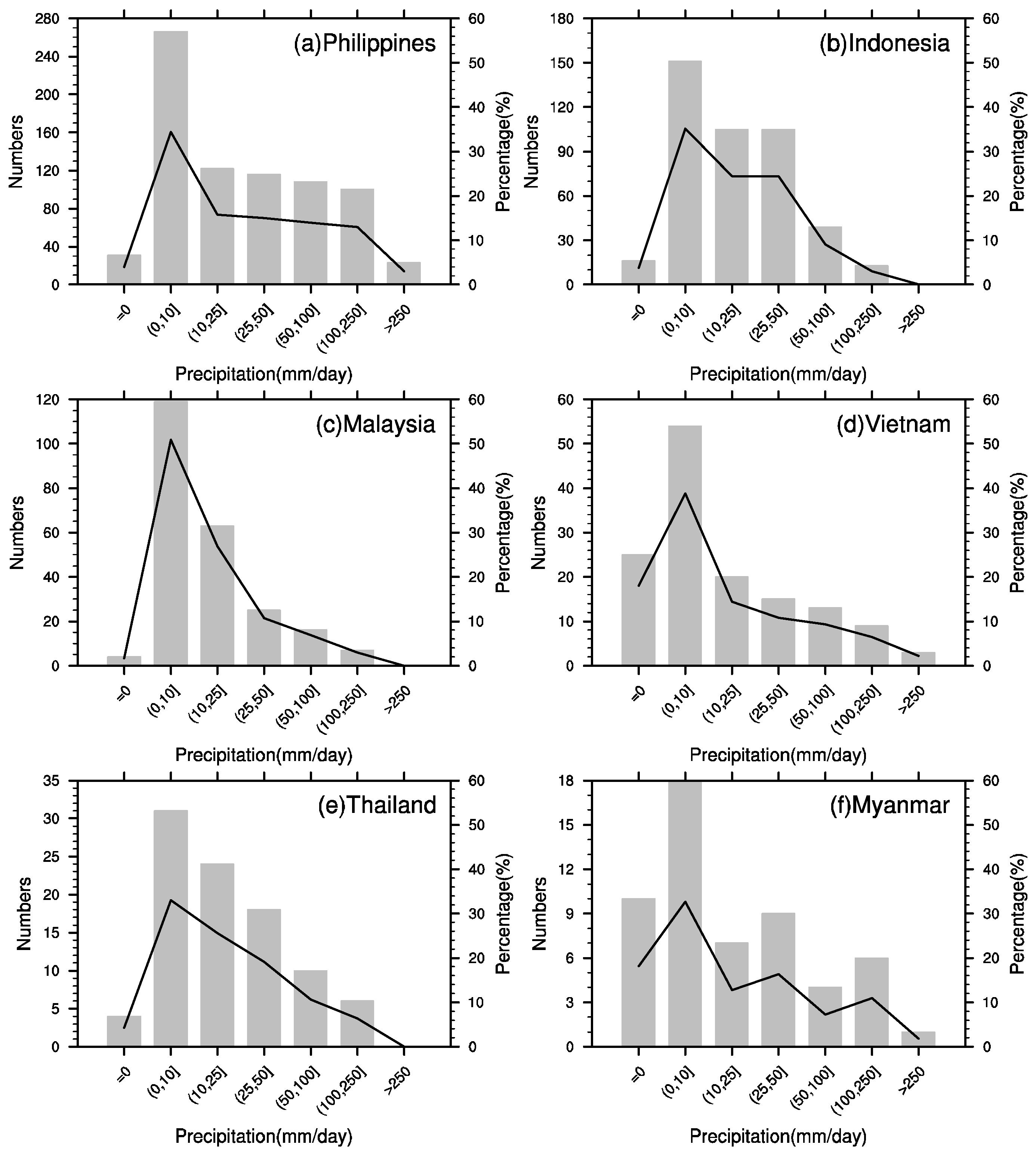
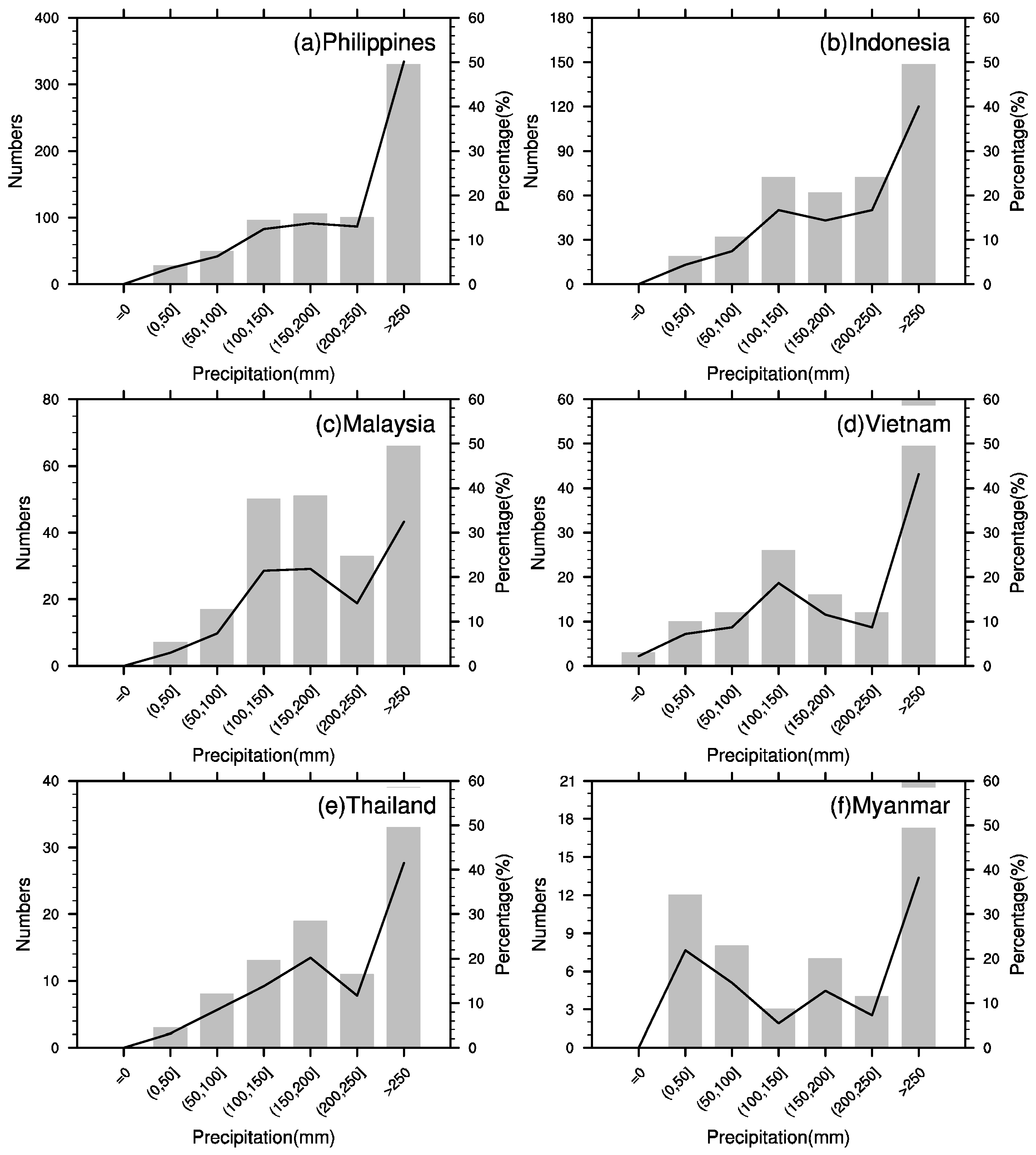
Precipitation significantly influences the onset of geologic calamities (e.g., landslides and mudflows). As depicted in Figure 5, there is a clear correlation between the incidence of landslides and varying intensities of rainfall recorded on the days they transpire. The data indicates that rainfall is a common antecedent to landslide events. With the exception of Myanmar (Figure 5f) and Vietnam (Figure 5d), in ASEAN nations, the frequency of landslides during rainy days exceeds 90%, with Malaysia witnessing a striking 98% correlation (Figure 5c). Notably, the majority of landslides are linked to light rainfall (0–10 mm/d), with decreasing occurrences during moderate (10–25 mm/d) and heavy rainfall (25–50 mm/d).
Contrary to expectations, the data from Figure 5 suggest that higher rainfall volumes correspond with fewer landslides, underscoring that rainfall amount on the date of landslide occurrence is not the sole determinant of landslide incidence. It is imperative to also take into account antecedent rainfall and its duration. As shown in Figure 6, the number of landslides in ASEAN countries significantly increases with the rise in cumulative precipitation prior to the landslide events. When the accumulated rainfall exceeds 250 mm, there is a sharp increase in the frequency of landslides, accounting for more than 30% of the total number of landslides in these countries.
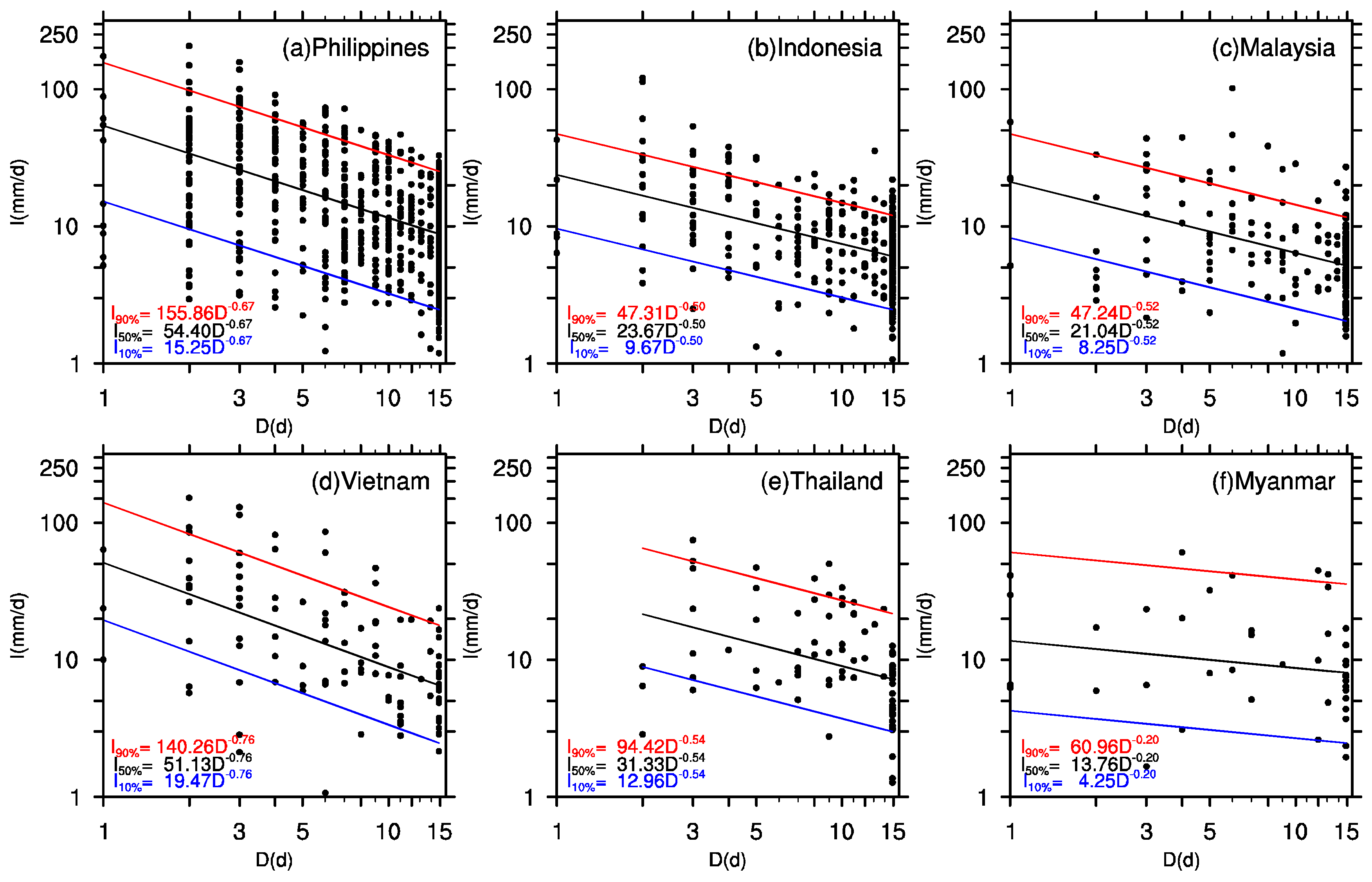
Utilizing the methodologies outlined in Section 2.2, we calculated the rainfall intensity (I) and duration (D) for each landslide occurrence. A log–log scatter plot ((log(I) = log(a) + blog(D); detailed information can be found in the work of Brunetti et al. [25]) of these I and D values led to the formulation of an ID threshold line (Figure 7, black solid line), which indicates a 50% probability of a landslide in ASEAN countries. The blue and red solid lines in Figure 7 represent the 10% and 90% probability thresholds, respectively.
Figure 7 delineates the median likelihood of landslide occurrence (50% chance) across six ASEAN nations through the following threshold equations: I 50 % = 54.40 D 0.67 (Philippines), I 50 % = 23.68 D 0.50 (Indonesia), I 50 % = 21.04 D 0.52 (Malaysia), I 50 % = 51.13 D 0.76 (Vietnam), I 50 % = 31.33 D 0.54 (Thailand) and I 50 % = 13.76 D 0.20 (Myanmar). In Peninsular Malaysia, the mean rainfall intensity–duration equation to determine the minimum average rainfall intensity that could trigger shallow landslides obtained by Maturidi et al. [16] is I = 17.5 D 0.72 . It needs to be noted that the parameters above were determined using all landslide events. Equations are slightly changed when using sub-samples, for example, the random selected 540 (70%, training set) landslide events in the Philippines achieved the equation I 50 % = 49.73 D 0.67 . However, percentages of landslide events exceeding three threshold curves (90%, 50%, and 10%) in the testing set (the rest 30% landslide events) are similar to the training set, indicating the equation in our paper is validated. These equations allow for the computation of the pivotal rainfall thresholds that correspond to a moderate probability of landslide incidents in these countries, as summarized in Table 2.
Table 2 illustrates the pronounced variability in the rainfall thresholds that are critical for initiating landslides within the ASEAN region. For example, a 50% chance of landslide in the Philippines equates to a one-day effective rainfall of 54.40 mm, which serves as the country’s landslide risk benchmark for such a duration. However, the rainfall threshold for landslides can reach as high as 70 mm in Baguio, Philippines [27]. The table further indicates that the Philippines and Vietnam exhibit the highest rainfall thresholds, necessitating more intense precipitation to provoke landslides. Conversely, Myanmar’s threshold is notably low, with a mere 13.76 mm of effective daily rainfall being sufficient to trigger a landslide, corroborating the findings presented in Section 3 regarding Myanmar’s susceptibility to large-scale landslides and the resultant higher fatality rates.

5. Conclusions

Utilizing the comprehensive global landslide database covering the years 2006 to 2018, this study conducted a detailed analysis of the spatial and temporal variations of geological landslides in the ASEAN countries. It identified the common characteristics of landslide occurrences in the ASEAN region and, by incorporating high-resolution global satellite precipitation data, developed rainfall intensity–duration (ID) curves for each country. This enabled the identification of distinct precipitation thresholds that trigger landslide events in these areas. The key findings are outlined as follows:
Firstly, the distribution of landslide occurrences in ASEAN member states exhibits a strong correlation with the latitudinal shifts of the regional rain belt. Particularly, the Philippines, Java Island in Indonesia, and the Malay Peninsula stand out as areas with a heightened frequency of landslide events, averaging more than 2.5 instances annually.
Secondly, about 41.4% of the landslides in ASEAN countries have resulted in fatalities, with instances causing over 10 deaths representing 15.6% of the total cases. The Philippines and Indonesia have recorded the highest numbers of landslide-induced fatalities, collectively surpassing 2000 lives lost. Notably, Myanmar has the largest proportion of substantial landslide events, accounting for 27.3%. The likelihood of fatal landslides in Myanmar is particularly pronounced, with an average fatality rate per incident of 10.89 individuals, significantly higher compared to other countries. Landslides with mortality tolls exceeding ten individuals are predominantly seen in Indonesia, the Philippines, and the northern regions of the Indochina Peninsula.
Thirdly, the majority of landslides in ASEAN territories occur on rainy days, with a significant proportion happening on days with light precipitation. According to the established landslide threshold curve, the Philippines has the highest effective daily rainfall threshold at 54.40 mm, while Myanmar has the lowest at 13.76 mm with a 50% probability of a landslide occurrence. However, except for precipitation, other variables such as land cover, soil type, soil moisture, and slope [28,29,30] also exert significant influence on landslides, and they should be considered in the future.

Author Contributions

Conceptualization, Z.X.; methodology, F.C.; software, Y.C.; validation, Z.X., W.L. and Y.C.; formal analysis, J.S.; investigation, W.L.; resources, W.L.; data curation, F.C.; writing—original draft, W.L. All authors have read and agreed to the published version of the manuscript.

Funding

This work was jointly sponsored by the National Natural Science Foundation of China (grant 42365004), the Natural Science Foundation of Guangxi, China (grant 2024GXNSFAA010211), and the Guangxi Key Research and Development Program (Guike AB21196041; Guike AB22035016).

Institutional Review Board Statement

Not applicable.

Informed Consent Statement

Not applicable.

Data Availability Statement

The database on landslide incidents can be freely downloaded from https://gpm.nasa.gov/landslides/ (accessed on 5 January 2022). The Integrated Multi-satellite Retrievals for GPM (IMERG) daily satellite precipitation product can be obtained from https://disc.gsfc.nasa.gov/datasets/ (accessed on 5 January 2022).

Conflicts of Interest

The authors declare that there are no conflicts of interest.

References

  1. Barman, J.; Soren, D.D.L.; Biswas, B. Landslide susceptibility evaluation and analysis: A review on articles published during 2000 to 2020. In Monitoring and Managing Multi-Hazards. GIScience and Geo-Environmental Modelling; Das, J., Bhattacharya, S.K., Eds.; Springer: Cham, Switzerland, 2023. [Google Scholar]
  2. Sim, K.B.; Lee, M.L.; Wong, S.Y. A review of landslide acceptable risk and tolerable risk. Geoenviron. Dis. 2022, 9, 3. [Google Scholar] [CrossRef]
  3. Keaokiriya, P.; Shivakoti, B.; Goto, T.; Sakai, H.; Dewi, A.; Jayasinghe, S.; Basnayake, S.; Kartiko, R.D.; Arambepola, N.M.S.I. Disaster risk reduction in the ASEAN region: Understanding and assessing systematic risks of floods and landslides in a river basin context. 2022. Available online: https://www.undrr.org/media/80192/download (accessed on 1 May 2024).
  4. Li, Y.; Meng, H.; Dong, Y.; Hu, S. Main types and characteristics of geo-hazard in China-Based on the results of geo-hazard survey in 290 counties. Chin. J. Geol. Hazard Control 2004, 15, 29–34. (In Chinese) [Google Scholar]
  5. Bai, S.; Wang, J.; Thiebes, B.; Cheng, C.; Yang, Y. Analysis of the relationship of landslide occurrence with rainfall: A case study of Wudu County, China. Arab. J. Geosci. 2014, 7, 1277–1285. [Google Scholar] [CrossRef]
  6. Guzzetti, F.; Peruccacci, S.; Rossi, M.; Stark, C.P. The rainfall intensity-duration control of shallow landslides and debris flows: An update. Landslide 2008, 5, 3–17. [Google Scholar] [CrossRef]
  7. Zhou, J.; Tang, M.G.; Xu, Q.; Wu, H.L.; Wang, X.M. Early warning model of rainfall-induced landslide in Chongqing of China based on rainfall threshold. Mt. Res. 2022, 40, 847–858. (In Chinese) [Google Scholar]
  8. Chen, L.H.; Yang, H.P.; Liao, L.P.; Xiao, L. Study on the rainfall threshold of the landslide disaster in Rong County in June 2010. J. Nat. Dis. 2023, 32, 228–235. [Google Scholar]
  9. Glade, T.; Crozier, M.; Smith, P. Applying probability determination to refine landslide-triggering rainfall thresholds using an empirical “Antecedent Daily Rainfall Model”. Pure Appl. Geophys. 2000, 157, 1059–1079. [Google Scholar] [CrossRef]
  10. Chen, H.K.; Wei, L.; Tan, L. Review of research on empirical rainfall threshold of rainfall-induced landslide. J. Chongqing Jiaotong Univ. (Nat. Sci.) 2012, 31, 990–996. (In Chinese) [Google Scholar]
  11. Caine, N. The rainfall intensity-duration control of shallow landslides and debris flows. Geogr. Ann. 1980, 62, 23–27. [Google Scholar]
  12. Lin, W.; Li, Y.Y.; Xu, Y.; Lian, Z.P.; Cao, Y.; Shen, Y.F. Rainfall thresholds of rainfall-triggered landslides in Cili county, Hunan province. J. Yangtze River Sci. Res. 2020, 37, 48–54. (In Chinese) [Google Scholar]
  13. Xia, M.X.; Li, Y.Y.; Wu, J.M.; Lian, Z.P.; Lin, W. Research on rainfall early warming threshold of landslide disaster in Zhangjiajie city based on I-D statistical model. J. Nat. Dis. 2021, 30, 203–212. (In Chinese) [Google Scholar]
  14. Dai, C.R.; Huang, W.; Li, M.; Zhang, M.D.; Li, C.H.; Zhu, Y. County-level rainfall warming thresholds for rainfall-induced landslides in Yunnan. Meteorol. Sci. Technol. 2015, 43, 675–680. (In Chinese) [Google Scholar]
  15. Huang, J.; Ju, N.P.; Liao, Y.J.; Liu, D.D. Determination of rainfall thresholds for shallow landslides by a probabilistic and empirical method. Nat. Hazards Earth Sci. Syst. 2015, 15, 2715–2723. [Google Scholar] [CrossRef]
  16. Maturidi, A.M.A.M.; Kasim, N.; Abu Taib, K.; Azahar, W.N.A.W.; Tajuddin, H.B.A. Empirically based rainfall threshold for landslides occurrence in Peninsular Malaysia. KSCE J. Civ. Eng. 2021, 25, 4552–4566. [Google Scholar] [CrossRef]
  17. Maturidi, A.M.A.M.; Kasim, N.; Abu Taib, K.; Azahar, W.N.A.W. Rainfall-induced landslide thresholds development by considering different rainfall parameters: A review. J. Ecol. Eng. 2021, 22, 85–97. [Google Scholar] [CrossRef]
  18. Li, M.Y.; Han, T.T.; Hao, X. Regional characteristics of extreme precipitation events in Eurasia. Trans. Atmos. Sci. 2020, 43, 687–698. (In Chinese) [Google Scholar]
  19. Zhou, B.T.; Xu, Y.; Han, Z.Y.; Shi, Y.; Wu, J.; Li, R.K. CMIP5 projected changes in mean and extreme climate in the Belt and Road region. Trans. Atmos. Sci. 2020, 43, 255–264. (In Chinese) [Google Scholar]
  20. An, D.; Eggeling, J.; Zhang, L.; He, H.; Sapkota, A.; Wang, Y.-C.; Gao, C. Extreme precipitation patterns in the Asia–Pacific region and its correlation with El Niño-Southern Oscillation (ENSO). Sci. Rep. 2023, 13, 11068. [Google Scholar] [CrossRef]
  21. Kirschbaum, D.B.; Stanley, T.; Zhou, Y.P. Spatial and temporal analysis of a global landslide catalog. Geomorphology 2015, 249, 4–15. [Google Scholar] [CrossRef]
  22. Sheng, Y.F.; Li, Y.Y.; Xu, Y.; Wu, J.M.; Lin, W. Prediction of rainfall-type landslides based on effective rainfall intensity and logistic regression. Hydrogeol. Eng. Geol. 2019, 46, 156–162. (In Chinese) [Google Scholar]
  23. Huang, F.M.; Chen, J.W.; Fan, X.M.; Huang, J.S.; Zhou, C.B. Logistic regression fitting of rainfall-induced landslide occurrence probability and continuous landslide hazard prediction modelling. Earth Sci. 2022, 47, 4609–4628. (In Chinese) [Google Scholar]
  24. Liu, H.Z.; Ma, Z.F.; Fan, G.Z. Relationship between landslide/debris flow and rainfall in typical region of Sichuan province. Bull. Soil Water Conserv. 2016, 36, 74–77. (In Chinese) [Google Scholar]
  25. Brunetti, M.T.; Peruccacci, S.; Rossi, M.; Luciani, S.; Valigi, D.; Guzzetti, F. Rainfall thresholds for the possible occurrence of landslides in Italy. Nat. Hazard. Earth Syst. 2010, 10, 447–458. [Google Scholar] [CrossRef]
  26. Froude, M.J.; Petley, D.N. Global fatal landslide occurrence from 2004 to 2016. Nat. Hazard. Earth Syst. 2018, 18, 2161–2181. [Google Scholar] [CrossRef]
  27. Nolasco-Javier, D.; Kumar, L.; Tengonciang, A.M.P. Rapid appraisal of rainfall threshold and selected landslides in Baguio, Philippines. Nat. Hazard. 2015, 78, 1587–1607. [Google Scholar] [CrossRef]
  28. Cullen, C.A.; Suhili, R.A.; Aristizabal, E. A landslide numerical factor derived from CHIRPS for shallow rainfall triggered landslides in Colombia. Remote Sens. 2022, 14, 2239. [Google Scholar] [CrossRef]
  29. Liu, S.; Du, J.; Yin, K.; Zhou, C.; Huang, C.; Jiang, J.; Yu, J. Regional early warning model for rainfall induced landslide based on slope unit in Chongqing, China. Eng. Geol. 2024, 333, 107464. [Google Scholar] [CrossRef]
  30. Ray, R.L.; Jacobs, J.M. Relationships among remotely sensed soil moisture, precipitation and landslide events. Nat. Hazard. 2007, 43, 211–222. [Google Scholar] [CrossRef]
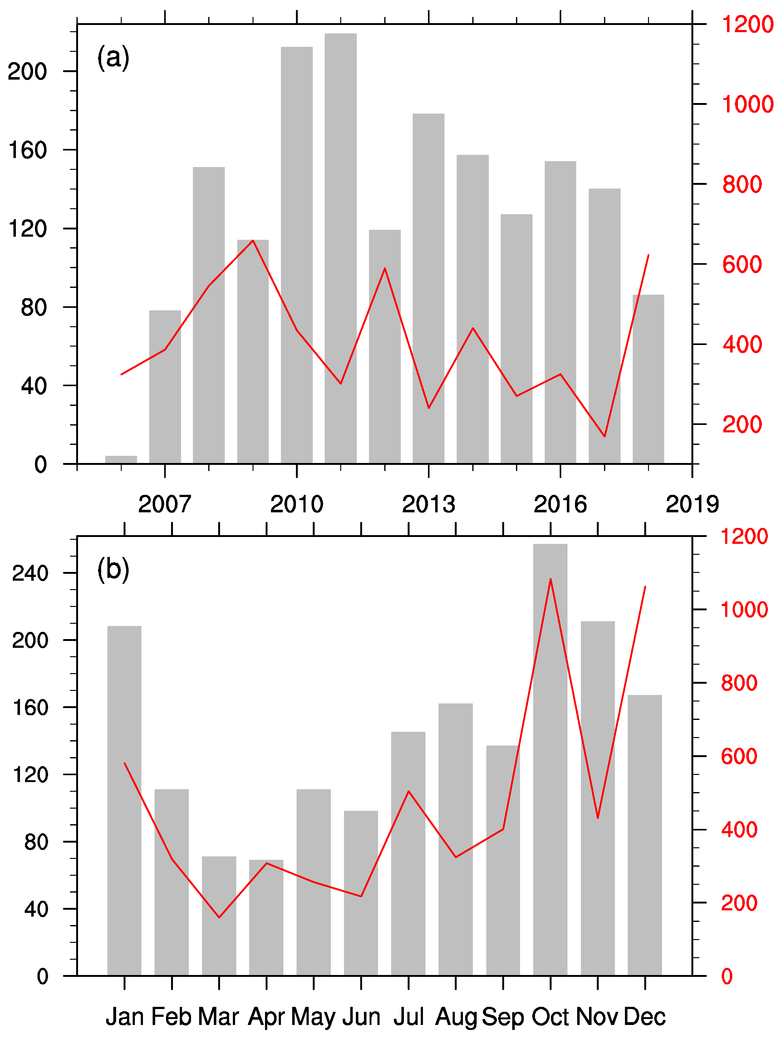
Figure 1. (a) The variations of landslide events (gray) and death toll (red) in ASEAN nations from 2006 to 2018 by year and (b) their monthly variability summed to the same period.
Atmosphere 15 00599 g001
Figure 2. Spatiotemporal distributions of landslides in ASEAN countries (a) and the average annual landslide frequency (b); units: times per year.
Atmosphere 15 00599 g002
Figure 3. Spatial distributions of the number of deaths caused by each landslide in ASEAN countries.
Atmosphere 15 00599 g003
Figure 4. Number of landslides in ASEAN countries (a), total deaths caused (b), average deaths per landslide (c), and percentage of fatal landslide events (d) during 2006–2018.
Atmosphere 15 00599 g004
Figure 5. Number of landslides (bar charts) and their percentages (solid line, %) with different daily rainfall amounts (mm/d) in the top six countries with the highest number of landslides.
Atmosphere 15 00599 g005
Figure 6. Same as Figure 5, but the x-axis is the cumulative rainfall during the 15 days prior to the landslide’s occurring day.
Atmosphere 15 00599 g006
Figure 7. ID threshold curves for landslide disasters in six ASEAN countries. The y-axis represents the average rainfall intensity (I, unit: mm/d), and the x-axis represents the rainfall duration (D, unit: d). The black, blue, and red solid lines represent the 50%, 10%, and 90% probability thresholds, respectively.
Atmosphere 15 00599 g007
Table 1. Proportion of each landslide scale in the six countries with the most landslides (%).
Landslide ScaleSmall ScaleMedium ScaleLarge-ScaleExtra-Large ScaleUnknown
Philippines10.278.97.81.31.8
Indonesia6.370.816.31.94.9
Malaysia24.465.45.604.7
Vietnam7.277.010.85.00
Thailand31.957.49.601.1
Myanmar3.663.627.305.5
Table 2. Critical rainfall thresholds for landslide disasters in ASEAN countries (mm).
Rainfall Days (d)12345
CountryPhilippines54.4088.52114.50135.90154.31
Indonesia23.6840.3753.9865.7576.27
Malaysia21.0435.7447.6657.9467.09
Vietnam51.1381.28103.42121.19136.19
Thailand31.3352.8570.1284.9097.99
Myanmar13.7625.7536.8447.2557.24
Disclaimer/Publisher’s Note: The statements, opinions and data contained in all publications are solely those of the individual author(s) and contributor(s) and not of MDPI and/or the editor(s). MDPI and/or the editor(s) disclaim responsibility for any injury to people or property resulting from any ideas, methods, instructions or products referred to in the content.