Review

Agricultural Disaster Prevention System: Insights from Taiwan’s Adaptation Strategies

by
Ming-Hwi Yao
1,*,
Yung-Heng Hsu
2,
Ting-Yi Li
2,
Yung-Ming Chen
2,
Chun-Tang Lu
3,
Chi-Ling Chen
4 and
Pei-Yu Shih
5
1
Agricultural Engineering Division, Taiwan Agricultural Research Institute, Taichung City 413008, Taiwan
2
National Science and Technology Center for Disaster Reduction, New Taipei City 231007, Taiwan
3
Agricultural Development and Service Center, Taiwan Agricultural Research Institute, Taichung City 413008, Taiwan
4
Agricultural Chemistry Division, Taiwan Agricultural Research Institute, Taichung City 413008, Taiwan
5
Tainan District Agricultural Research and Extension Station, Tainan City 712009, Taiwan
*
Author to whom correspondence should be addressed.
Atmosphere 2024, 15(5), 526; https://doi.org/10.3390/atmos15050526
Submission received: 23 February 2024 / Revised: 19 April 2024 / Accepted: 20 April 2024 / Published: 25 April 2024
(This article belongs to the Special Issue Agriculture-Climate Interactions in Tropical Regions)

Abstract

:
In response to the adverse effects of climate change-induced frequent extreme disasters on agricultural production and supply stability, this study develops a comprehensive agricultural disaster prevention system based on current adaptation strategies for mitigating agricultural meteorological disasters. The primary goal is to enhance disaster preparedness and recovery through three core platforms: a fine-scale weather forecast service system, a crop disaster early warning system, and an agricultural information service platform for disasters. The results show that every major agricultural production township in Taiwan now has dedicated agricultural weather stations and access to refined weather forecasts. Additionally, a disaster prevention calendar for 76 important crops is established, integrating cultivation management practices and critical disaster thresholds for different growth periods. Utilizing this calendar, the crop disaster early warning system can provide timely disaster-related information and pre-disaster prevention assistance to farmers through various information dissemination tools. As a disaster approaches, the agricultural information service platform for disasters provides updates on current crop growth conditions. This service not only pinpoints areas at higher risk of disasters and vulnerable crop types but also offers mitigation suggestions to prevent potential damage. Administrative efficiency is then improved with a response mechanism incorporating drones and image analysis for early disaster detection and rapid response. In summary, the collaborative efforts outlined in this study demonstrate a proactive approach to agricultural disaster prevention. By leveraging technological advancements and interdisciplinary cooperation, the aim is to safeguard agricultural livelihoods and ensure food security in the face of climate-induced challenges.

1. Introduction

Taiwan is an island with a subtropical marine climate and has experienced natural disasters in recent decades. Disaster occurrences have been on a steady rise, accompanied by an intensified severity of damage [1]. This has resulted in the deterioration of both the natural environment and infrastructure, endangering agricultural production and indirectly increasing the vulnerability of food security. Considering the anticipated deterioration of agricultural farming in the future, it becomes an urgent and imperative task to establish a comprehensive disaster prevention system. However, the objective of agricultural disaster management is to diminish or avert the potential risk posed by disasters, offer farmers instant and appropriate disaster prevention, and improve disaster prevention through message coordination and transfer. Agricultural disaster prevention is complex and emphasizes integrity. In particular, it is crucial to improve farmers’ ability to autonomously prevent disasters. Therefore, meteorological data collection and analysis, along with weather forecasts, are utilized to generate agricultural disaster information to assist farmers in carrying out disaster prevention. Disaster prevention is a series of information integration and actual disaster prevention operations, and, therefore, it is necessary to establish a complete agricultural disaster prevention system.
Climate change has had an impact on the global agricultural environment [2]. While there is still no scientific consensus on whether it affects the occurrence of extreme weather events, recent meteorological data from Taiwan indicate changes in the types and frequencies of disasters affecting agricultural losses [3,4]. Regardless of whether these changes are short-term phenomena, establishing a comprehensive disaster prevention system is crucial. This includes the development of early warning systems and disaster prevention technologies for different disasters and the application of information and communications technology (ICT) tools for disseminating disaster information to farmers. These efforts are essential for adapting to future climate change and constructing a resilient and sustainable agricultural system. In fact, when a disaster strikes, a comprehensive disaster prevention and notification mechanism should be in place to help mitigate the disaster and reduce the damage. Therefore, the scope and degree of agricultural disasters should be classified according to severity levels, and a disaster early warning system should be established in response to the specific damage caused by agricultural disasters to different crops, considering that the types and intensities of disasters differ region by region and the vulnerabilities of crops to disasters are also different. For example, when the northeastern part of Taiwan is affected by a monsoon in the winter, a phenomenon of excessive rain often occurs. Long-term rain and high humidity cause flowers to be unable to pollinate and reduce production. This is a specific disaster affected by terrain and seasons. Therefore, the establishment of a disaster prevention system must consider different disaster types and seasons when crops are vulnerable. In addition, a complete disaster prevention system must allow farmers to receive information and respond immediately. Rozaki et al. [5] proposed disaster mitigation strategies for Indonesian farmers, indicating farmers must have their own adaptation methods to tackle disasters, but they also need help from the government or research institutions, such as information systems and educational opportunities, to make good use of various resources to enhance their disaster reduction management.
Disaster management involves pre-disaster risk reduction and post-disaster recovery [6,7,8]. The former can be accomplished by combining an early warning system with a standard operating procedure (SOP), where the early warning system serves as a cost-effective strategy to avoid the loss of farmer income [9]. A complete early warning system for crop management should involve the following components: 1. continuous monitoring and real-time updates, as farmers must be aware of potential disaster threats; 2. highly accurate forecasts and information; 3. a suitable information delivery approach to ensure prompt dissemination of information; and 4. effective and seamless coordination among information receivers to optimize the early warning system [10]. Accurate weather forecasts before the occurrence of disasters play a key role in the efficiency of disaster prevention efforts. In particular, the actual agricultural disaster prevention operations take longer, such as early harvesting or the construction of disaster prevention facilities. For example, in the case of a typhoon invasion, whether it will land and the path of the invasion are related to the disaster-stricken area and the identification of vulnerable crops, but an earlier warning means higher uncertain risks. Therefore, the introduction of disaster probability is very important, which assists farmers in understanding various information to facilitate judgment and implementation of disaster prevention actions.
The core concepts of modern disaster research include hazards, risks, vulnerability, and resilience [11]. Experts’ scientific knowledge is the basis for improving disaster risk management [12], especially the interaction between crop physiological and meteorological conditions. On the other hand, disaster issues are closely related to social levels, especially for farmers [13,14]. Albris et al. [15] analyzed the EU disaster prevention plan and indicated three gaps in the overall promotion of disaster prevention: 1. the epistemological gap: the understanding of different scientific knowledge, especially the differences between promoters and farmers; 2. the strategy gap: there is no consensus on the extent to which scientific or expert knowledge should be used in cropping plans; 3. the dissemination gap: expert knowledge needs to be clearly translated to end users. In the face of the continued deterioration of the global climate, disaster reduction strategies have encountered many problems. On the premise of ensuring stable food supply and farmers’ income, the construction of a disaster prevention and reduction information system is an important task for the agricultural sector to achieve climate resilience. This article mainly introduces the research progress in agricultural disaster prevention in Taiwan. Although disaster forecasting still has scientific limitations and disaster prevention can only aim at “disaster reduction”, it is still possible to establish a comprehensive agricultural disaster prevention system through scientific and technological research and development efforts to achieve the goal of smart climate agriculture. The agricultural disaster prevention system described in this paper is relatively broad and includes activities that contribute to disaster warning and mitigation, such as information systems, disaster prevention technologies, disaster prevention calendars, and UAV disaster survey operations.

2. Current Situation of Agrometeorological Disasters in Taiwan

Meteorological disasters frequently impede agricultural production in Taiwan, resulting in annual losses ranging from 1 to 27 billion NTD. These setbacks lead to income losses for farmers, disrupting the stable supply of agricultural products and prompting consumer complaints. Typical agrometeorological disasters in the region consist of drought, typhoons, heavy rainfall, and chilling injury, including frost injury and cool damage. Thus, the Taiwanese government launched a research program for agricultural meteorological disaster adaptation strategies to strongly promote disaster prevention information and technology, as well as offer fine-scale weather forecasts and an early warning system in support of agricultural disaster preparedness and recovery. Moreover, the initiative could shift from passive mitigation to proactive measures by disseminating information to agricultural practitioners. This study presented an overview of the current state of agricultural disasters in Taiwan, focusing on three key aspects: crop losses caused by agricultural disasters, information and communication technology for agricultural disaster prevention, and research and development in disaster prevention technology.
Taiwan, characterized by its rugged mountainous terrain, frequently experiences various meteorological disasters, especially typhoons, and heavy rainfall can bring strong winds or flooding, causing crop plant lodging and root rot. Figure 1 depicts the crop loss statistics spanning the past three decades (1992–2021). It is observed that typhoons pose the most significant risk to crop production, contributing to approximately 68.4% of the damage. Damage caused by rainfall, including the East Asian rainy season, spring rain, and convectional rain, constitutes 17.0%. Cold damage affects the first season of rice, fruit trees, and tea trees, making up around 7.4% of the damage. The remaining proportion of the damage is attributed to drought (3.9%), hailstones (1.7%), high temperatures (0.3%), and foehn wind (0.1%). Furthermore, fruits are the most vulnerable crops to weather, accounting for 52.5% of the losses, followed by vegetables (25.9%) and rice (9.5%). Crop damage severity is affected by several factors, including the stages of crop growth, the cultivation environment, and the crop’s susceptibility to disasters. Taking Taiwan’s main cereal crop—rice—as an example, its seedling stage is sensitive to chilling injury, its flowering stage is sensitive to water shortage, and during the ripening stage, its grains are susceptible to strong winds and induced lodging phenomena. Each crop growth stage has a sensitive period for specific meteorological conditions. The crop loss statistics highlight that severe crop losses are greatly influenced by the farming period and region. On the other hand, it can be seen from Figure 1 that Taiwan’s disaster damage pattern is changing gradually. Historical disaster statistics show that typhoons and rainfall are the most important causes of agricultural losses. However, the number of typhoons hitting Taiwan has decreased significantly in recent years. Rainfall caused by typhoons accounts for about 40% of Taiwan’s water resources, which indirectly causes frequent droughts. However, at the same time, the losses caused by heavy rainfall have also increased, which indicates that the overall rainfall pattern is developing toward extremes. In addition, when the moisture in the air decreases, different types of pests and diseases increase significantly. It can be seen that the types of disasters interact with each other.
Agricultural disaster prevention is the primary meteorological observation and forecasting service. Taiwan is small in area but has a complex terrain. Although there are 700 weather stations distributed over 36,197 square kilometers of land, the density of agricultural areas is not high. The establishment of weather stations is the top priority. While meteorological data for forecasting services are available, the crucial challenge lies in establishing the link between meteorological data and crop cultivation management for effective agricultural disaster prevention. In addition, various adaptation strategies for disaster prevention must be accepted and implemented by farmers. This study first divides each disaster event into normal, pre-disaster, during-disaster, and post-disaster stages, according to the timeline, and then develops corresponding information systems and promotion tools (Figure 2) in consideration of farmers’ actual needs. Various research and development work is carried out to enhance farmers’ ability to autonomously prevent disasters. The relevant research and development results are shown and discussed as follows:

3. Agricultural Disaster Prevention System

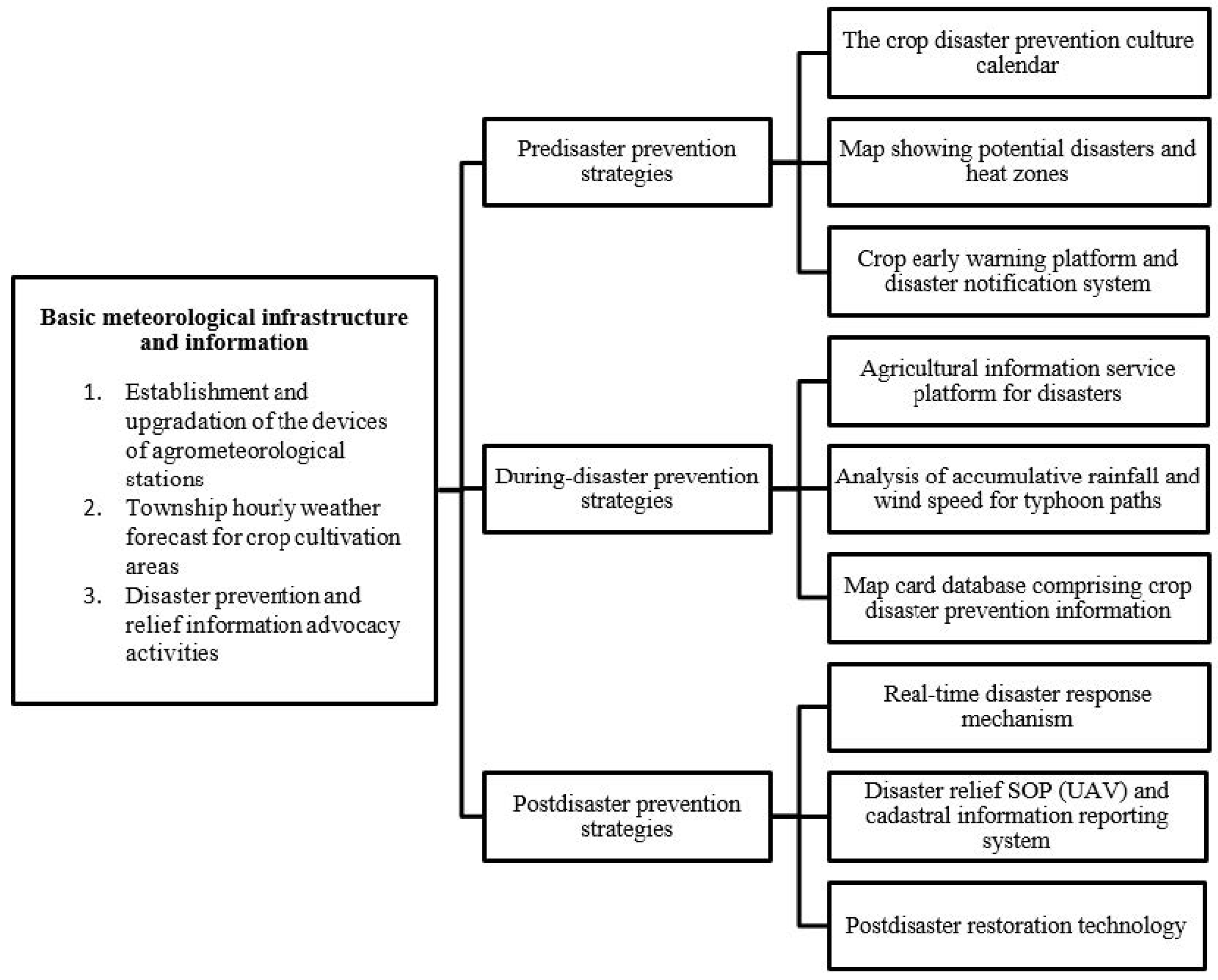
3.1. Basic Meteorological Infrastructure and Information

Information on weather forecasts and disaster warnings comes from real-time observation data. Regarding the current situation of weather station installations over agricultural production areas in Taiwan, our Ministry of Agriculture and the Central Weather Administration cooperated to establish the “Agricultural Meteorological Observation Network” in 1986. A total of 17 agricultural meteorological stations have been established. However, after 30 years, the Agricultural Meteorological Observation Network has experienced problems such as outdated instruments and poor quality of observation data. Therefore, the Ministry of Agriculture and the Central Weather Administration once again cooperated to upgrade existing agricultural meteorological stations and establish new meteorological stations in consideration of disaster hotspots or important agricultural production areas. Consequently, there were a total of 176 agricultural meteorological stations by 2021, and agricultural meteorological station observation data were available for data download by personnel affiliated with the Ministry of Agriculture for agricultural information system development, disaster assessment, and the provision of crop cultivation guidance to farmers. This is very helpful for meteorological information push services [16]. In addition to increasing the density of weather stations, the quality of observation data is also very important. We have established a meteorological data verification system. When the data are found to be unreasonable, the system will immediately notify the operator through communication software to eliminate obstacles or replace sensors. The assurance of data quality is contingent upon the establishment of a comprehensive maintenance mechanism.
There is a huge demand for weather forecasting services, particularly concerning disaster warning and agricultural operations. At present, the Central Weather Administration offers township forecasts with high spatial resolution, where forecasts are set at grid points based on the locations of township and district offices. However, agricultural production areas are often far away from urban areas, and, therefore, existing forecast points are of limited help to farmers in field management. To tackle this issue, we established a fine-scale weather forecast service system (https://agr.cwa.gov.tw/, accessed on 25 April 2024) for important agricultural production areas. Currently, weather forecast services have been furnished for 392 agricultural production areas, with a forecast resolution of approximately 2.5 × 2.5 km. The forecasts extend for a period of 7 days, and the data are updated every 3 h. The authority has planned to add 30 new forecast points every year in the future. It is expected that every agricultural township and vulnerable crop production area can access weather forecast services.

3.2. Pre-Disaster Prevention Strategies

The susceptibility to weather differs from crop to crop. Beyond the genetic traits of crops, the way weather conditions are perceived in various growth stages plays a crucial role in determining the susceptibility of crops to climatic factors. For instance, rice exhibits remarkable tolerance to temperatures above 35 °C in the growth stage; yet, high temperatures in the flowering or grain-filling stages may lead to rice’s sterility or quality degradation [17]. Moreover, elucidating the disaster probability in individual growth stages of crops, coupled with crucial thresholds identified by farmer interviews, simulation experiments, and literature reviews, can serve as a basis for developing disaster warning systems. At the same time, to understand the relationship between crop growth period and disaster critical value and also integrate the cultivation and management suggestions required during the crop growth process, our team compiled a “disaster prevention cultivation calendar” for economically important crops, including crop growth stages by “month”, possible meteorological disasters, disaster-causing meteorological critical values, disaster prevention suggestions and measures, fertilizers, and pest and disease management. This calendar is more helpful for disaster prevention awareness. Figure 3 shows the established mango disaster prevention cultivation calendar, which includes mango growth stages from January to December of the year, cultivation management suggestions, possible disasters, and critical disaster-causing conditions. At present, the disaster prevention cultivation calendar for 76 economically important crops has been completed. The disaster cultivation calendar has been posted on the Internet for reference by all walks of life. However, some critical disaster conditions are difficult to determine, especially rainfall and wind speed. For crops that currently have no relevant data, heavy rain level (≥80 mm per day) and level 10 wind speed (Beaufort wind force scale) are used as default values, which will be updated with new information.
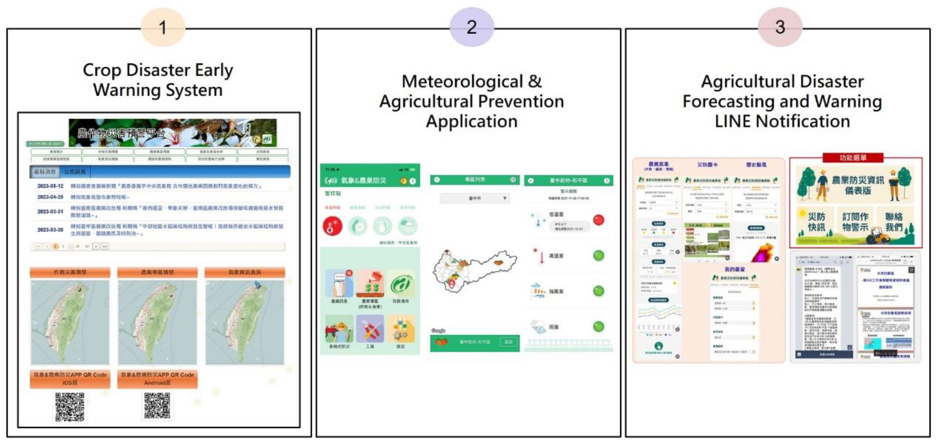
This program combined crucial thresholds for crops and fine-scale weather forecasts to establish the desired “crop disaster early warning system” (https://disaster.tari.gov.tw, accessed on 25 April 2024) (Figure 4). It can automatically determine the probability of agricultural meteorological disasters, with green, yellow, and red lights representing normal, caution, and warning levels, respectively. The display method is acceptable to farmers and is conducive to information promotion. Additionally, the system provides access to the most recent activity information, instant observational data, weather forecasts tailored for farming sites, updates on disasters, and historical data, such as Taiwan’s agricultural disaster rates, agricultural climate patterns, and maps indicating hotspots. It also includes a disaster prevention cultivation calendar, information on twenty-four solar terms, and achievements of the agricultural disaster prevention program. The abundance of agrometeorological and disaster prevention information aims to assist farmers in reducing disaster-induced crop losses. In addition, we explored a smartphone application system to provide farmers with convenient access to crop disaster information (Figure 4).

3.3. During-Disaster Prevention Strategies

When a disaster is approaching, what information services can assist farmers? We explored an “agricultural information service platform for disaster” available at https://eocdss.ncdr.nat.gov.tw/web/MOA, accessed on 25 April 2024 to furnish details on the prevailing crop growth status in disaster-prone areas, roadway conditions in agricultural production sites, and disaster prevention SOPs. Taking a typhoon as an example, once the disaster probability hits a specific threshold when the typhoon’s path is determined, the estimated strong wind speed reaches the level of crop damage; this information will be disseminated to agricultural extension stations, farmers’ associations, and crop cultivation and trade coalitions. Subsequently, the dissemination of disaster information and prevention measures will occur through messaging services, the Internet, and communication channels. Furthermore, during government disaster response meetings, decision-makers can promptly access agricultural disaster information presented by weather and hydrological monitoring maps. When the possibility of disasters increases, farmers need to be reminded to take precautions. When a disaster occurs, the forecast content and probability of the disaster must be revised at any time. The normal operation is to update every 3 h and then send the latest forecast results through the service platform, which will provide disaster information, including typhoon paths, estimated rainfall, instantaneous maximum wind speed, areas prone to flooding, and other information. On the other hand, the service platform will integrate the actual growth conditions of crops in each district, especially crops in the harvesting and flowering stages. The actual growth status of crops and the degree of disaster impact in each district will be reported immediately by researchers from various experimental units across Taiwan. Additionally, it will provide various disaster prevention suggestions that are integrated into disaster early warning briefings and graphical presentations for reminding farmers to take disaster prevention actions, where suggestions are updated based on real-time disaster information.
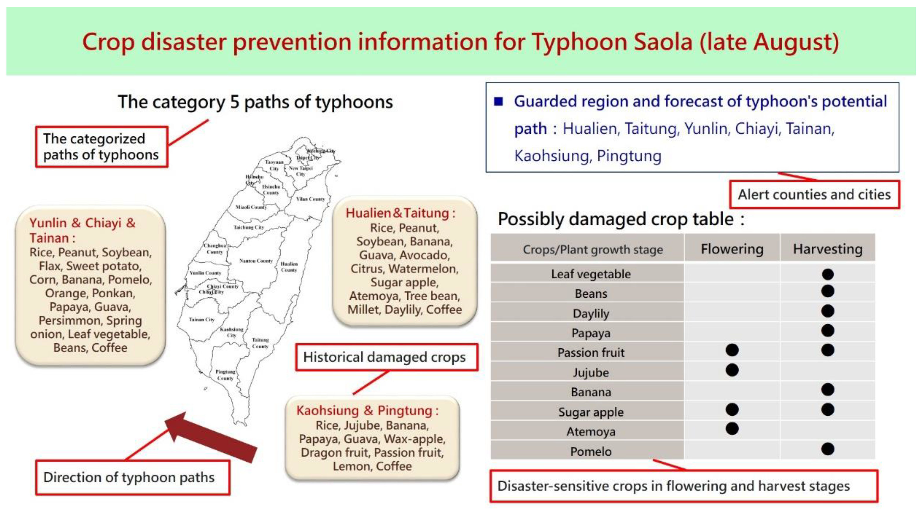
Given the diverse impacts of typhoon tracks on different locations, the Central Weather Administration has selected nine typhoon tracks for Taiwan. Moreover, certain areas may not directly face typhoons but are susceptible to heavy rains and strong winds due to the complex terrain in Taiwan. Therefore, each typhoon event is classified based on historical agricultural damage and meteorological data, while warning areas associated with each path are divided for early warning purposes. According to the crops in the harvesting or flowering period at warning areas, a database of “crop disaster prevention information map cards” is established (Figure 5). Currently, map cards are produced biweekly, targeting disasters such as cold damage in April, heavy rain damage from May to July, southwest airflow from July to November, and nine historical typhoon paths from May to November. The information on map cards includes the estimated risk of agricultural crops being damaged, enabling farmers to quickly browse the crops that require attention during this disaster.
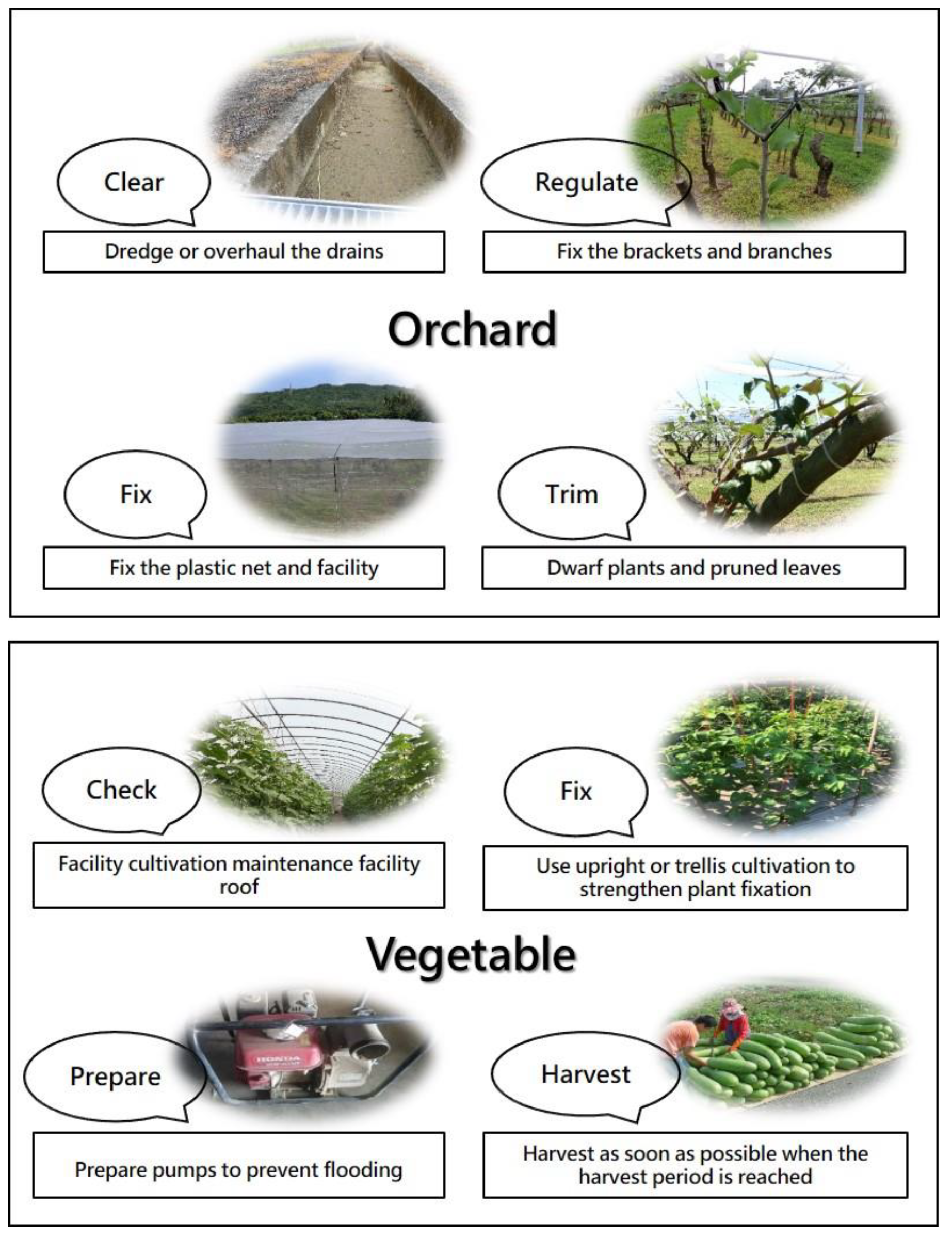
Agricultural information not only identifies crop production areas with a higher risk of disasters and the types of crops that may be affected but also offers disaster prevention (mitigation) suggestions. These suggestions focus on various crops such as rice, grains, fruits, vegetables, flowers, and greenhouses while providing prevention and control measures with text and illustrations. The disaster awareness map card tool was confirmed by agricultural disaster response procedures, and crop experts in each field immediately released disaster warning information to farmers for carrying out disaster reduction work in the field as soon as possible. For example, when a typhoon approaches, fruit farmers need to dredge or overhaul the drains, fix the brackets or branches, reinforce nets and facilities, manage the height of dwarf fruit plants, and prune leaves (Figure 6). Based on simple photos, farmers can carry out the prevention procedure to reduce losses. The map card is like a checklist for disaster prevention measures, and farmers can confirm and complete the disaster prevention and preparation work.
In response to approaching typhoons, the central disaster response is mostly initiated when a sea warning is issued. Various administrative departments engage in tasks such as inspecting drainage gates, coordinating highway traffic responses, regulating ship entry, and managing class suspension. However, the agricultural warning is initiated three days before the sea warning. The main reason is that agricultural preparedness requires more time. For example, early harvesting of rice or fruits involves the deployment of harvesting machinery and manpower. However, the earlier the disaster warning, the higher the associated uncertainty. All agricultural operators should understand that it is still difficult to grasp the path of a typhoon invading Taiwan. The closer it is to Taiwan, the more accurate its path and landfall location will be. However, since the time of a typhoon invading Taiwan is easier to predict than its path, disaster prevention measures can be implemented based on the invasion time. For example, Hualien County is one of the taros-producing areas in Taiwan, but it is located in high-typhoon-prone areas. Farmers often trim taro leaves to prevent strong winds from lifting up the roots. However, trimming taro leaves will delay ripening. Therefore, it is recommended that farmers first evaluate the time required for trimming taro leaves. For example, if it takes one day, they will decide whether to trim leaves to prevent the typhoon based on the forecasted path provided to the Central Weather Administration the day before the predicted typhoon invasion. By familiarizing themselves with disaster uncertainties and response operations procedures, they can reduce the risk of typhoon damage.

3.4. Post-Disaster Prevention Strategies

Following a disaster, the main responsibilities of the government involve providing emergency relief funds and engaging in rehabilitation efforts. Yet, the government provides relief funds to encourage farmers to resume farming based on the degree of crop damage, but the determination is frequently a subject of controversy. The use of unmanned aerial vehicles (UAVs) for efficiently assessing landscapes, disaster regions, and agricultural damage enhances the creation of an imagery database pre- and post-disaster [18]. This not only helps address controversies but also allows for a more accurate estimation of crop losses. In this study, utilizing high-precision crop image recognition techniques specifically developed for establishing an SOP and collecting essential information on cultivation and disaster areas, UAVs equipped with a global positioning system (GPS) can capture high-quality images pre- and post-disaster. Subsequently, these images are analyzed with cadastral data and the geographic information system (GIS). The present program deploys UAVs to record real-time images, enhancing disaster investigation and rescue operations. For instance, paddy fields damaged by heavy rain during the monsoon season in June were monitored. The UAV images captured in this program offer high ground resolution (3.5 cm) with 3D point clouds. These resources are crucial for image discrimination, aiding in the creation of a digital surface model (DSM) to assess rice lodging [19,20]. Initially, the maximum likelihood method was applied to performing supervised classification on images to obtain rice lodging areas. Subsequently, the Pix4D Mapper Pro (Pix4D) was employed to generate 3D point clouds, facilitating the development of a DSM to classify rice lodging. We achieved an 85% accuracy in discriminating rice lodging through supervised image classification and an 87% accuracy in lodging level classification using the DSM. The results suggest that UAVs are capable of offering real-time images capturing crop damage caused by meteorological disasters, facilitating image recognition on rice lodging levels with satisfactory accuracy (>85%). Future research can employ both UAV and image recognition techniques in targeted crop fields. The outcomes of image classification were superimposed onto the administrative boundaries of rice paddies to create a GIS-based support system for discerning agricultural damage. As a result, the manpower and time needed for detecting and monitoring crop damage were significantly reduced.

4. Disaster Prevention and Avoidance Techniques

Agricultural disaster prevention strategies can be divided into two categories: one is the planning of suitable land and crops, especially crops planted in disaster-prone hotspots, which often encounter disasters but are difficult to prevent, such as areas prone to typhoons. During the harvest period, farmers should be advised to change their farming plan to achieve a disaster avoidance perspective for avoiding the recurrence of disaster losses. In addition, the research and development of disaster prevention and reduction technologies can reduce the risk of disasters through improvements in cultivation and management techniques, utilization of materials or facilities, and adjustment of production periods. Disaster prevention and reduction for crops with large areas but low yields per unit area can be achieved through the selection of suitable varieties and effective fertilizer management. In the case of horticultural crops, mulching can be used to avoid wind and rain damage, pillars can be used to fix the plants, and moderate pruning can be used to reduce damage.
Strategies for disaster prevention and mitigation involve targeting economically important crops, minimizing the risk of crop losses through facility use, adjusting planting times, and conducting suitability assessments. Taking southeastern Taiwan as an example, the region is susceptible to foehn winds, marked by low humidity and high temperatures. This situation may result in the scorching of flowers or immature fruits. Due to the sudden occurrence of this phenomenon, since the disaster occurs within 1–2 h, the time from the system notifying farmers to actually taking disaster prevention measures is often insufficient. In fact, farmers typically employ inexpensive foehn wind sensing devices integrated into their orchard sprinkler systems, traditionally adopted for the purposes of watering and fertilizing. When foehn winds are detected, the sensing device automatically activates the sprinkler system to reduce temperature and increase humidity, preventing damage caused by foehn winds. Another strategy involves using a spoiler fan to mitigate frost damage to tea trees. In addition, farmers often use field irrigation to raise soil temperature to reduce damage caused by cold waves. These prevention techniques prioritize low costs, ease of operation, and effectiveness in damage reduction.
In Taiwan, meteorological disasters are predominantly attributed to typhoons. Typhoons bring strong winds and heavy rains, which are extremely destructive. How can we reduce the losses caused by strong winds? Windproof nets are a common disaster reduction method used by farmers to prevent summer typhoons or northeast monsoons by reducing lodging or fruit drop caused by strong winds. There have been many studies on the design of windproof nets, the selection of material characteristics, wind tunnel experiments, and on-site observation and verification [21,22]. However, in terms of the practical application of wind protection technology, it is imperative to provide farmers with real-time suggestions for erecting wind protection nets through model analysis based on local conditions and weather information. In this study, we set up an assessment procedure to identify the optimal status of windbreak nets using a computational fluid dynamics (CFD) model [23], which serves as a benchmark to protect crops. The findings indicated that the CFD simulation can be verified using varying mesh sizes and heights of windbreak nets. Our experiments suggest that the optimal length (height) against wind is 6 (1.3) multiples of the windbreak net’s height. In the actual case of a typhoon, the maximum gust of 18 m/s can be reduced to 4 m/s using the windbreak net with a blocking rate of 70%. The case suggests that the wind-proof effect is significant.

5. Conclusions

Taiwan’s diverse landscape often faces agricultural disasters, affecting crop yields and farmers’ incomes. Climate-smart agriculture (CSA) is pivotal, requiring both technological advancements and policy advocacy [24]. Our study presents a holistic disaster prevention approach, encompassing early warning systems before disasters, disaster prevention operations and preparations during disasters, and post-disaster recovery technology promotion alongside insurance policies. Central to this approach are agricultural meteorological stations and fine-scale weather forecasts. The established agricultural disaster prevention system features three main platforms: a fine-scale weather forecast service system, a crop disaster early warning system, and an agricultural information service platform for disasters. Despite progress with 176 weather stations and 392 forecast sites, challenges persist, especially in hilly regions and for specific disaster types like drought, foehn wind, and salt wind damage. Addressing climate change demands further research, tailored prevention measures, and empowering farmers in disaster readiness. Future endeavors should prioritize public–private collaborations, expanded access to meteorological services, broader crop coverage, diverse information channels, and enhanced warning systems to ensure sustainable agricultural disaster prevention.

Author Contributions

For this research article, M.-H.Y. wrote the draft of the paper; previous outcomes of the studies were provided by Y.-H.H., C.-L.C. and P.-Y.S.; Y.-M.C. and C.-T.L. supervised the researches; M.-H.Y. and T.-Y.L. edited the paper. All authors have read and agreed to the published version of the manuscript.

Funding

This research was funded by the Ministry of Agriculture, Republic of China, Taiwan, grant No. 105-2101-01-11-01.

Institutional Review Board Statement

Not applicable.

Informed Consent Statement

Not applicable.

Data Availability Statement

Not applicable.

Acknowledgments

This article is the result of the implementation of the science and technology plan. Participating units include the Central Meteorological Administration, the National Science and Technology Center for Disaster Prevention, various district agricultural research and extension stations, and universities. We would like to thank them for their contribution to the disaster prevention plan. The authors also extend their sincere appreciation to the editors and anonymous reviewers for their valuable and constructive feedback, which has significantly enhanced the quality and depth of the manuscript.

Conflicts of Interest

The authors declare no conflict of interest.

References

  1. Jian, G.J.; Teng, J.H.; Wang, S.T.; Cheng, M.D.; Cheng, C.P.; Chen, J.H.; Chu, Y.J. An Overview of the Tropical Cyclone Database at the Central Weather Bureau of Taiwan. Terr. Atmos. Ocean. Sci. 2022, 33, 26. [Google Scholar] [CrossRef]
  2. Bibi, F.; Rahman, A. An Overview of Climate Change Impacts on Agriculture and their mitigation strategies. Agriculture 2023, 13, 1508. [Google Scholar] [CrossRef]
  3. Chiu, M.C.; Chen, C.L.; Chen, C.W.; Lin, H.J. Weather fluctuation can override the effects of integrated nutrient management on fungal disease incidence in the rice fields in Taiwan. Sci. Rep. 2022, 12, 4273. [Google Scholar] [CrossRef]
  4. Lin, Y.H.; Lin, H.I.; Wen, F.I.; Sheu, S.J. The impact of enhancements to weather-forecasting services on agricultural investment behavior: A field experiment in Taiwan. Weather Clim. Soc. 2021, 13, 211–226. [Google Scholar] [CrossRef]
  5. Rozaki, Z.; Wijaya, O.; Rahmawati, N.; Rahayu, L. Farmers’ Disaster Mitigation Strategies in Indonesia. Rev. Agric. Sci. 2021, 9, 178–194. [Google Scholar] [CrossRef]
  6. Seneviratne, K.; Baldry, D.; Pathirage, C. Disaster knowledge factors in managing disasters successfully. Int. J. Strateg. Prop. Manag. 2010, 14, 376–390. [Google Scholar] [CrossRef]
  7. FAO. The Impact of Disasters and Crises on Agriculture and Food Security: 2021; Food and Agriculture Organization of the United Nations: Rome, Italy, 2021. [Google Scholar] [CrossRef]
  8. Al-Wathinani, A.M.; Barten, D.G.; Borowska-Stefańska, M.; Gołda, P.; AlDulijan, N.A.; Alhallaf, M.A.; Samarkandi, L.O.; Almuhaidly, A.S.; Goniewicz, M.; Samarkandi, W.O.; et al. Driving Sustainable Disaster Risk Reduction: A Rapid Review of the Policies and Strategies in Saudi Arabia. Sustainability 2023, 15, 10976. [Google Scholar] [CrossRef]
  9. Dhanya, P.; Geethalakshmi, V. Reviewing the Status of Droughts, Early Warning Systems and Climate Services in South India: Experiences Learned. Climate 2023, 11, 60. [Google Scholar] [CrossRef]
  10. Tembo, G.; Chimai, B.; Tembo, N.; Ndiyoi, M. Observations on Zambia’s Crop Monitoring and Early Warning Systems. J. Agric. Sci. 2014, 6, 99–107. [Google Scholar] [CrossRef]
  11. Kelman, I. Lost for words amongst disaster risk science vocabulary? Int. J. Disaster Risk Sci. 2018, 9, 281–291. [Google Scholar] [CrossRef]
  12. Gotham, K.F. The Social Roots of Risk: Producing Disasters, Promoting Resilience by Kathleen J. Tierney. Am. J. Sociol. 2015, 121, 646–648. [Google Scholar] [CrossRef]
  13. Shi, P.; Ye, T.; Wang, Y.; Zhou, T.; Xu, W.; Du, J.; Wang, J.; Li, N.; Huang, C.; Liu, L.; et al. Disaster Risk Science: A Geographical Perspective and a Research Framework. Int. J. Disaster Risk Sci. 2020, 11, 426–440. [Google Scholar] [CrossRef]
  14. Hadlos, A.; Aaron, O.; Ali Hadigheh, S. Where does local and indigenous knowledge in disaster risk reduction go from here? A systematic literature review. Int. J. Disaster Risk Reduc. 2022, 79, 103160. [Google Scholar] [CrossRef]
  15. Albris, K.; Lauta, K.C.; Raju, E. Disaster knowledge gaps: Exploring the interface between science and policy for disaster risk reduction in Europe. Int. J. Disaster Risk Sci. 2020, 11, 1–12. [Google Scholar] [CrossRef]
  16. Yao, M.H.; Leou, T.M.; Hsu, Y.H.; Chen, C.L.; Lu, C.T. Developing Disaster Early Warning System and Adaptation Strategies for Crop Production in Taiwan; Workshop of Strengthening the Prevention Strategies and Early Warning Systems of Agricultural Disasters through Information and Communication Technology (ICT), Taiwan Agricultural Research Institute: Taichung, Taiwan, 2018. [Google Scholar]
  17. Krishnan, P.; Ramakrishnan, B.; Raja Reddy, K.; Reddy, V.R. High-temperature effects on rice growth, yield, and grain quality. Adv. Agron. 2011, 111, 87–206. [Google Scholar] [CrossRef]
  18. Ning, J.; Zhou, F.; Zhou, J. Estimation of rice wind-disaster lodging area based on UAV multi-spectral remote sensing data. Sci. Technol. Eng. 2022, 22, 13723–13729. [Google Scholar]
  19. Chou, C.Y.; Wu, S.Y.; Chen, C.L. Rice lodging detection using the photography from unmanned aerial vehicle (UAV). J. Taiwan Agric. 2020, 69, 25–45. [Google Scholar] [CrossRef]
  20. Guo, Y.; He, J.; Zhang, H.; Shi, Z.; Wei, P.; Jing, Y.; Yang, X.; Zhang, Y.; Wang, L.; Zheng, G. Improvement of Winter Wheat Aboveground Biomass Estimation Using Digital Surface Model Information Extracted from Unmanned-Aerial-Vehicle-Based Multispectral Images. Agriculture 2024, 14, 378. [Google Scholar] [CrossRef]
  21. Pan, X.; Wang, Z.; Gao, Y.; Dang, X. Effects of row spaces on windproof effectiveness of simulated shrubs with different form configurations. Earth Space Sci. 2021, 8, e2021EA001775. [Google Scholar] [CrossRef]
  22. Fu, Z.; Li, Q. Study on Wind-Proof Effect and Stability of Windbreak Fence in Alpine Skiing Center. Sustainability 2023, 15, 3369. [Google Scholar] [CrossRef]
  23. Chen, J.L.; Yang, S.S.; Yao, M.H. Effectiveness analysis of windbreak using the CFD models. Crop Environ. Bioinform. 2017, 14, 31–39. [Google Scholar] [CrossRef]
  24. Debnath, P.; Hasan, M.M.; Biswas, A.K.M.A.A.; Biswas, A. Adoption of disaster risk reduction strategy in agriculture sector at Southkhali Union of Sharankhola Upazila, Bangladesh. Archives Agric. Environ. Sci. 2019, 4, 141–150. [Google Scholar] [CrossRef]
Figure 1. Crop losses resulting from various disasters in Taiwan (1992–2021).
Atmosphere 15 00526 g001
Figure 2. Strategies for crop disaster prevention and tools for disseminating information.
Atmosphere 15 00526 g002
Figure 3. Crop disaster prevention calendar.
Atmosphere 15 00526 g003
Figure 4. Products of dissemination of different early disaster warning information: (1) information platform; (2) app; (3) LINE.
Atmosphere 15 00526 g004
Figure 5. Disaster information map card: example of a typhoon. The map card includes the potential path of the typhoon, alert areas, historically damaged crops, and high-alert crops.
Atmosphere 15 00526 g005
Figure 6. Inspection chart for crop disaster prevention operations: examples of orchard and vegetable.
Atmosphere 15 00526 g006
Disclaimer/Publisher’s Note: The statements, opinions and data contained in all publications are solely those of the individual author(s) and contributor(s) and not of MDPI and/or the editor(s). MDPI and/or the editor(s) disclaim responsibility for any injury to people or property resulting from any ideas, methods, instructions or products referred to in the content.

