Article

Ground-Based MAX-DOAS Observations for Spatiotemporal Distribution and Transport of Atmospheric Water Vapor in Beijing

1
School of Physics and Electronic Information, Anhui Normal University, Wuhu 241000, China
2
Key Laboratory of Environmental Optics and Technology, Anhui Institute of Optics and Fine Mechanics, Hefei Institutes of Physical Science, Chinese Academy of Sciences, Hefei 230031, China
3
The Science Island Branch of Graduate School, University of Science and Technology of China, Hefei 230026, China
4
China National Environmental Monitoring Centre, Beijing 100012, China
*
Author to whom correspondence should be addressed.
Atmosphere 2024, 15(10), 1253; https://doi.org/10.3390/atmos15101253
Submission received: 5 September 2024 / Revised: 15 October 2024 / Accepted: 17 October 2024 / Published: 20 October 2024
(This article belongs to the Section Atmospheric Techniques, Instruments, and Modeling)

Abstract

:
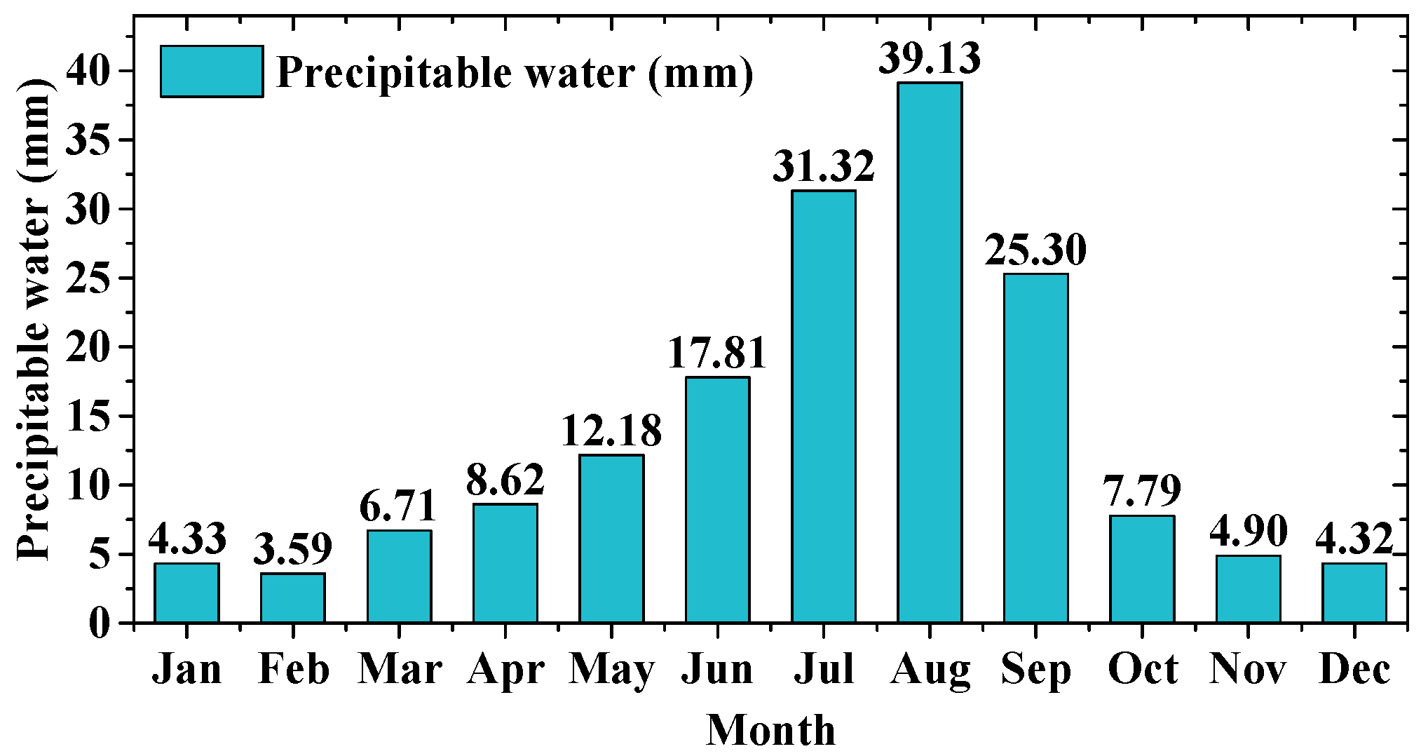
Understanding the spatiotemporal distribution and transport of atmospheric water vapor in urban areas is crucial for improving mesoscale models and weather and climate predictions. This study employs Multi-Axis Differential Optical Absorption Spectroscopy to monitor the dynamic distribution and transport flux of water vapor in Beijing within the tropospheric layer (0–4 km) from June 2021 to May 2022. The seasonal peaks in precipitable water occur in August, reaching 39.13 mm, with noticeable declines in winter. Water vapor was primarily distributed below 2.0 km and generally decreases with increasing altitude. The largest water vapor transport flux occurs in the southeast–northwest direction, whereas the smallest occurs in the southwest–northeast direction. The maximum flux, observed at about 1.2 km in the southeast–northwest direction during summer, reaches 31.77 g/m2/s (transported towards the southeast). Before continuous rainfall events, water vapor transport, originating primarily from the southeast, concentrates below 1 km. Backward trajectory analysis indicates that during the rainy months, there was a higher proportion of southeasterly winds, especially at lower altitudes, with air masses from the southeast at 500 m accounting for 69.11%. This study shows the capabilities of MAX-DOAS for remote sensing water vapor and offers data support for enhancing weather forecasting and understanding urban climatic dynamics.

1. Introduction

Atmospheric water vapor is a crucial greenhouse gas, playing an essential role in Earth’s energy balance and hydrological cycle [1]. The distribution and movement of water vapor influence regional weather patterns, including precipitation, cloud formation, and temperature fluctuations [2]. Research shows that one of the conditions for the formation of heavy rain is the continuous input of water vapor [3,4]. Studying the distribution and transport of water vapor is crucial for improving weather forecasting, and understanding extreme weather, and climate variability. Additionally, in areas with unique geographical or climatic features, such as coastal regions, mountainous areas, or urban environments, the dynamics of water vapor can be particularly complex [5,6,7]. Therefore, studying the spatiotemporal distribution and transport of water vapor in specific regions is essential for understanding local meteorological and climatic changes.
Beijing, as the capital of China, is not only an important metropolitan area but also a key location for the study of water vapor distribution and transport. Located in the northern part of the North China Plain, Beijing is surrounded by mountains to the west, north, and northeast, while the southeast opens onto a plain that gently slopes towards the Bohai Sea. This diverse terrain, along with the significant urban heat island effect and varying climatic conditions, creates a complex backdrop for water vapor distribution in Beijing [8]. Beijing has recently experienced multiple extreme precipitation events due to the combined effects of water vapor transport and terrain. For example, on 21 July 2012, 19 July 2016, and 31 July 2023 [9,10]. Studies have demonstrated that in various types of precipitation events occurring in the Beijing region, water vapor originating from multiple directions, including the west, northwest, south, and southeast, can play a vital role in contributing to rainfall [11]. Therefore, a deeper understanding of the spatiotemporal distribution and its multidirectional transport of water vapor in Beijing is of great importance for studies on urban extreme precipitation, climate research, and water resource planning.
The predominant techniques for monitoring atmospheric water vapor encompass satellite remote sensing, radiosondes, microwave radiometers, lidar, and the global positioning system [12,13,14,15,16], each with its distinct strengths in terms of spatial and temporal resolution, coverage, and data type. Satellite remote sensing, while offering extensive global coverage, tends to have lower spatial and temporal resolution. Radiosondes, widely used for assessing the vertical profile of water vapor, similarly suffer from limitations in spatial and temporal resolution. In contrast, microwave radiometers and lidar systems provide highly accurate observations of water vapor in the boundary layer under all weather conditions, albeit with higher costs and maintenance challenges. Global positioning system facilitates consistent water vapor measurements in all weather conditions but is constrained by its limited spatial resolution and the complexity of data processing.
The Multi-Axis Differential Optical Absorption Spectroscopy (MAX-DOAS) technique, characterized by its low cost, straightforward instrument setup, mature algorithms, and high spatiotemporal resolution, has emerged as a potent tool in atmospheric research [17,18,19]. By measuring the differential absorption of scattered sunlight in the atmosphere, MAX-DOAS has recently been employed for high-precision studies monitoring precipitable water and the vertical distribution of water vapor [20,21,22]. Furthermore, previous studies have indicated that integrating wind field data with MAX-DOAS technology can accurately determine water vapor transport fluxes [22]. This capability positions MAX-DOAS as an essential tool for studying the spatiotemporal distribution and transport of water vapor.
In this study, the spatial and temporal distribution and transport of water vapor in Beijing were analyzed using a MAX-DOAS instrument developed by the Anhui Institute of Optics and Fine Mechanics, China. First, we analyzed the seasonal variation characteristics of precipitable water and the vertical distribution of water vapor in the Beijing area. Second, by integrating wind profile data from the European Centre for Medium-Range Weather Forecasts (ECMWF) ERA5, we obtained the water vapor transport flux in multiple directions. This study particularly focused on analyzing the water vapor transport characteristics from different directions in Beijing, showcasing the effectiveness of MAX-DOAS in monitoring water vapor. The results promise to provide valuable data support for fields such as urban meteorology and climate science.

2. Instruments and Methods

2.1. MAX-DOAS Measurement

In this study, the MAX-DOAS system used was independently developed by the Anhui Institute of Optics and Fine Mechanics (AIOFM) of the Chinese Academy of Sciences. The experimental setup (Figure 1) was installed on the second-floor rooftop of the Beijing Meteorological Observatory (116.48° E, 39.81° N, 31 m above sea level), with an azimuth angle of 149° (north = 0°). The system consists of a spectrometer, a 360-degree controllable platform, a telescope, optical fibers, a computer, and surveillance cameras. The spectrometer was housed in a temperature-controlled box maintained at 25 °C. It has a spectral resolution of 0.6 nm and is capable of detecting a spectral range from 301.29 nm to 465.37 nm. The entire observation period was one year—from 1 June 2021 to 31 May 2022.
The QDOAS spectral fitting software (http://uv-vis.aeronomie.be/software/QDOAS/ (accessed on 3 May 2024)) developed by BIRAIASB was utilized to analyze the spectra collected by the MAX-DOAS. Differential Slant Column Densities (DSCDs) of dimeric oxygen (O4) and water vapor (H2O) were obtained within the wavelength intervals of 338–370 nm and 434–452 nm, respectively. To ensure the accuracy of the inversion results, data with a root mean square error exceeding 1 × 10⁻³ were excluded. According to prior research, at a wavelength of 442 nm, the influence of saturation absorption effects of water vapor on the retrieval results is negligible [23]. Therefore, this study does not consider the impact of water vapor saturation absorption.
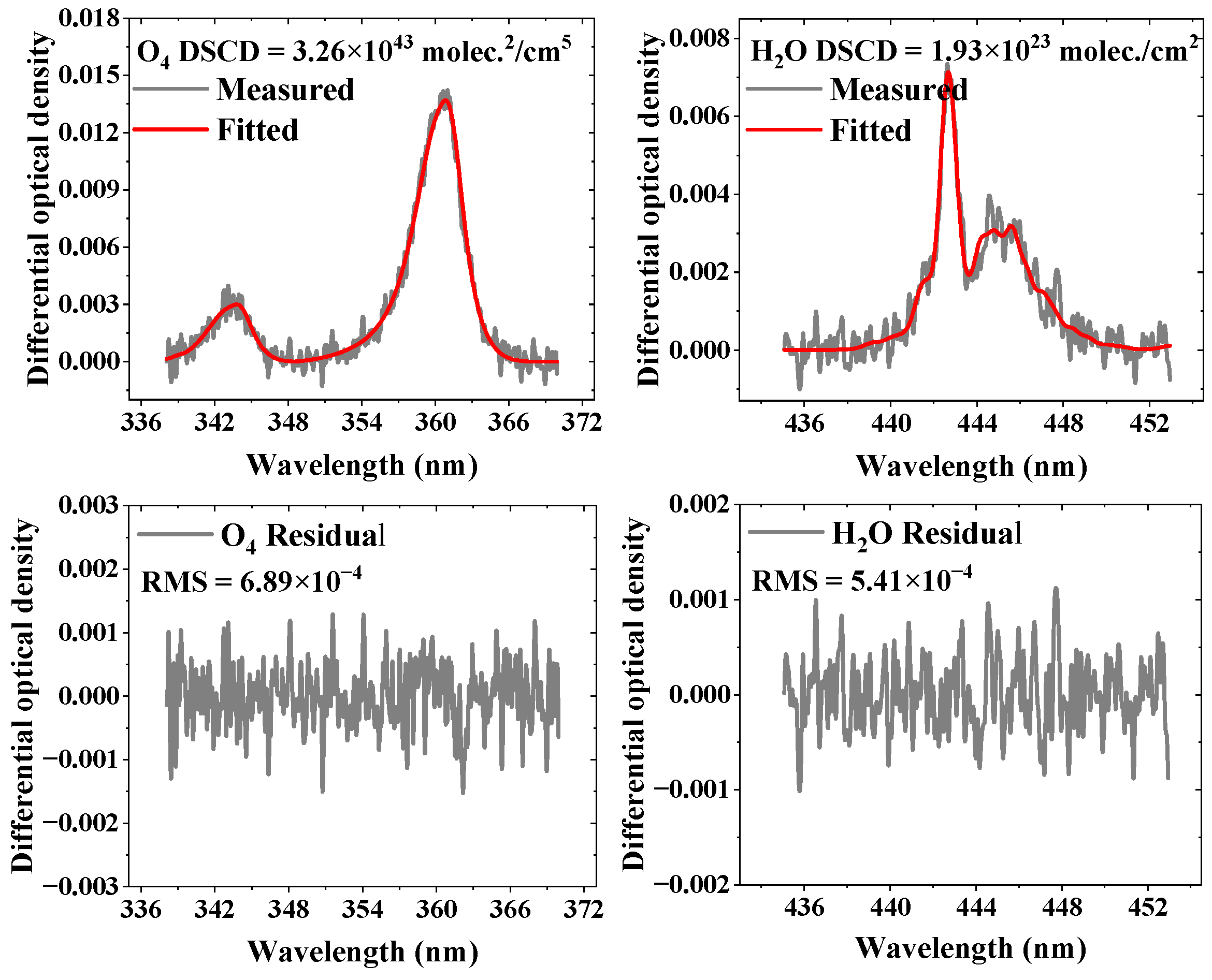
The retrieval of water vapor profiles is contingent upon the profiles of aerosol extinction coefficients, as discussed in Section 2.2. Since the variability of the aerosol extinction coefficient profile is a primary factor influencing the path of light transmission through the atmosphere, and the magnitude of the DSCD of O4 measured by MAX-DOAS is primarily indicative of the light’s transmission path, it is feasible to infer the vertical distribution of aerosols through multi-angle O4 DSCD measurements. Therefore, the retrieval of H2O absorption is conducted simultaneously with the retrieval of O4 absorption, which serves as an indicator of aerosol extinction. Figure 2 illustrates a DOAS fitting example for O4 and H2O from the morning of 14 May 2022, at 10:55:15.

2.2. Profile Retrieval

In this study, the atmospheric water vapor vertical profile retrieval algorithm used is the PriAM algorithm, jointly developed by the Anhui Institute of Optics and Fine Mechanics (AIOFM) and the Max Planck Institute of Chemistry (MPIC) [24,25,26]. PriAM is an optimal estimation retrieval algorithm based on the atmospheric radiative transfer model (SCIATRAN 2.2). The retrieval of atmospheric water vapor vertical distribution from DSCDs is affected by the state of aerosols, as they influence the path of light through the atmosphere. Consequently, the PriAM algorithm’s retrieval process is conducted in two steps. The first step involves retrieving the vertical distribution of aerosol extinction coefficients based on the optimal estimation method. The second step utilizes the aerosol information to retrieve the vertical distribution of water vapor, including the water vapor Vertical Column Density (VCD) and vertical profile. The aerosol extinction coefficients are retrieved from the DSCDs of O4 measured at multiple viewing angles. This approach is used because the magnitude of O4 DSCDs typically reflects the path of light transmission. The retrieved water vapor VCD from PriAM represents the integrated concentration vertically traversing the troposphere, also known in meteorology as the precipitable water [22]. Table 1 lists some of the model input parameters used in the PriAM algorithm for the retrieval of water vapor.

2.3. Transport Flux Calculation

The water vapor transport flux is defined as the mass of water vapor passing through a unit length perpendicular to the airflow direction per unit time. This parameter signifies both the strength and direction of water vapor transport. In this study, we employ wind field data from the ECMWF ERA5 reanalysis (https://cds.climate.copernicus.eu (accessed on 15 May 2024)), integrated with vertical profiles of water vapor obtained from MAX-DOAS retrievals, to calculate the water vapor transport flux. The ERA5 reanalysis dataset encompasses both zonal (u) and meridional (v) winds, allowing for the direct calculation of both zonal and meridional water vapor transport fluxes. Initially, following established methodologies [22], the u and v wind components are interpolated to the levels of the MAX-DOAS water vapor profiles. Subsequently, by applying the water vapor flux formula, we compute the zonal and meridional water vapor transport flux at a specific time t for the ith layer across a unit cross-sectional area. The calculation formulas are as follows
Q u , i , t = ( c i × u i ) t
Q v , i , t = ( c i × v i ) t
where Q u , i , t and Q v , i , t , respectively, signify the zonal and meridional water vapor transport fluxes. The variable c i represents the concentration of water vapor mixing ratio in the ith layer of the atmosphere, with the unit kg/m3. A positive value of Q u , i , t indicates a westerly transport (from west to east), whereas a negative value signifies an easterly transport (from east to west). Similarly, for Q v , i , t , a positive value denotes a southerly transport (from south to north), and a negative value indicates a northerly transport (from north to south).
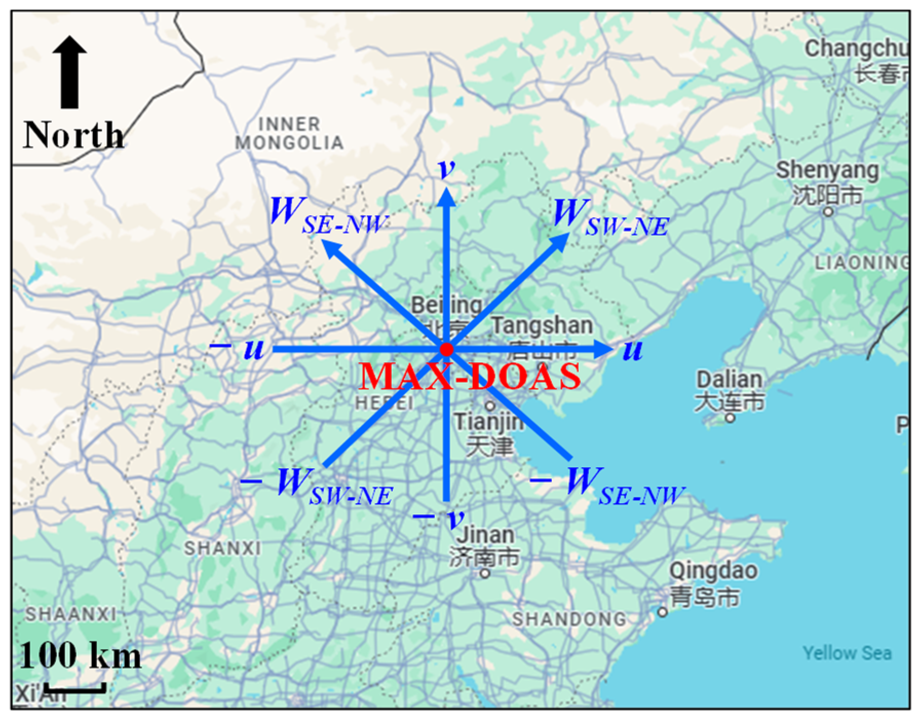
In Beijing, water vapor may be transported from several directions, such as the west, northwest, south, and southeast [11]. To further analyze the water vapor transport characteristics, we also computed the water vapor transport fluxes in both southwest–northeast and southeast–northwest orientations. These calculations required the decomposition of the u and v wind components. The wind speeds directions in the southwest–northeast ( W S W N E ) and southeast–northwest ( W S E N W ) for the ith layer are depicted in Figure 3.
Subsequently, the transport fluxes for the ith layer per unit cross-sectional area are calculated as follows
Q S W N E , i , t = ( c i × W S W N E , i ) t
Q S E N W , i , t = ( c i × W S E N W , i ) t
where Q S W N E , i , t and Q S E N W , i , t denote the water vapor transport fluxes in the southwest–northeast and southeast–northwest directions, respectively. A positive value of Q S W N E , i , t signifies movement from southwest to northeast, and a negative value indicates movement from northeast to southwest. Similarly, a positive value of Q S E N W , i , t represents movement from southeast to northwest, and a negative value signifies movement from northwest to southeast. The water vapor flux per unit cross-sectional area for the ith layer is expressed in g/m2/s.
The calculation of the vertically integrated transport flux is conducted by multiplying the transport flux per unit cross-sectional area by the sum of the heights of each layer. The vertical integral transport fluxes for the four directions are calculated as follows
Q u , t = i ( Q u , i , t × h i )
Q v , t = i ( Q v , i , t × h i )
Q S W N E , t = i ( Q S W N E , i , t × h i )
Q S E N W , t = i ( Q S E N W , i , t × h i )
where h i denotes the height resolution of the ith layer in the water vapor profile. Given that the detection range of MAX-DOAS is from 0 to 4 km, the study primarily focuses on calculating the vertically integrated water vapor flux within this 4 km range above the ground. As approximately 80% of water vapor is found below 4 km, the vertically integrated water vapor transport flux calculated in this study predominantly represents the transport of water vapor in the lower troposphere, measured in g/m/s.

2.4. MAX-DOAS Comparison Verification

To verify the accuracy of water vapor measurements from MAX-DOAS, we compared them with data from the Aerosol Robotic Network (AERONET) and ECMWF ERA5.

2.4.1. Comparison with AERONET

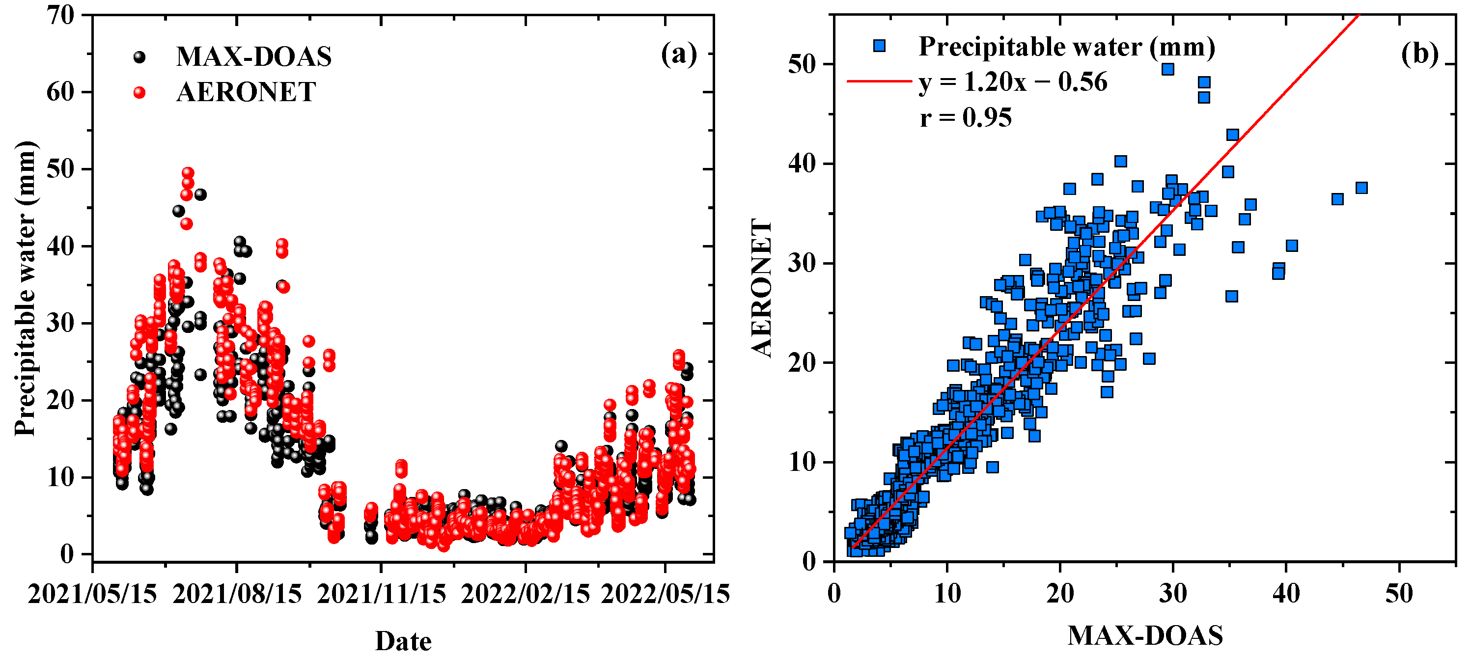
To validate the precipitable water measurements obtained from the Beijing MAX-DOAS station during the observation period, we conducted a comparison with data from the Beijing site of the AERONET database (https://aeronet.gsfc.nasa.gov/ (accessed on 18 May 2024)) located at 116.40° E, 40.0° N. Specifically, we compared the hourly average data of precipitable water from AERONET Level 1.5 (which includes cloud screening and quality control) with the measurements from MAX-DOAS. The results show a consistent trend between the two data sets (Figure 4). Moreover, the high Pearson correlation coefficient (r) of 0.95 and a slope of 1.2 indicate good consistency between the methods.

2.4.2. Comparison with ECMWF ERA5

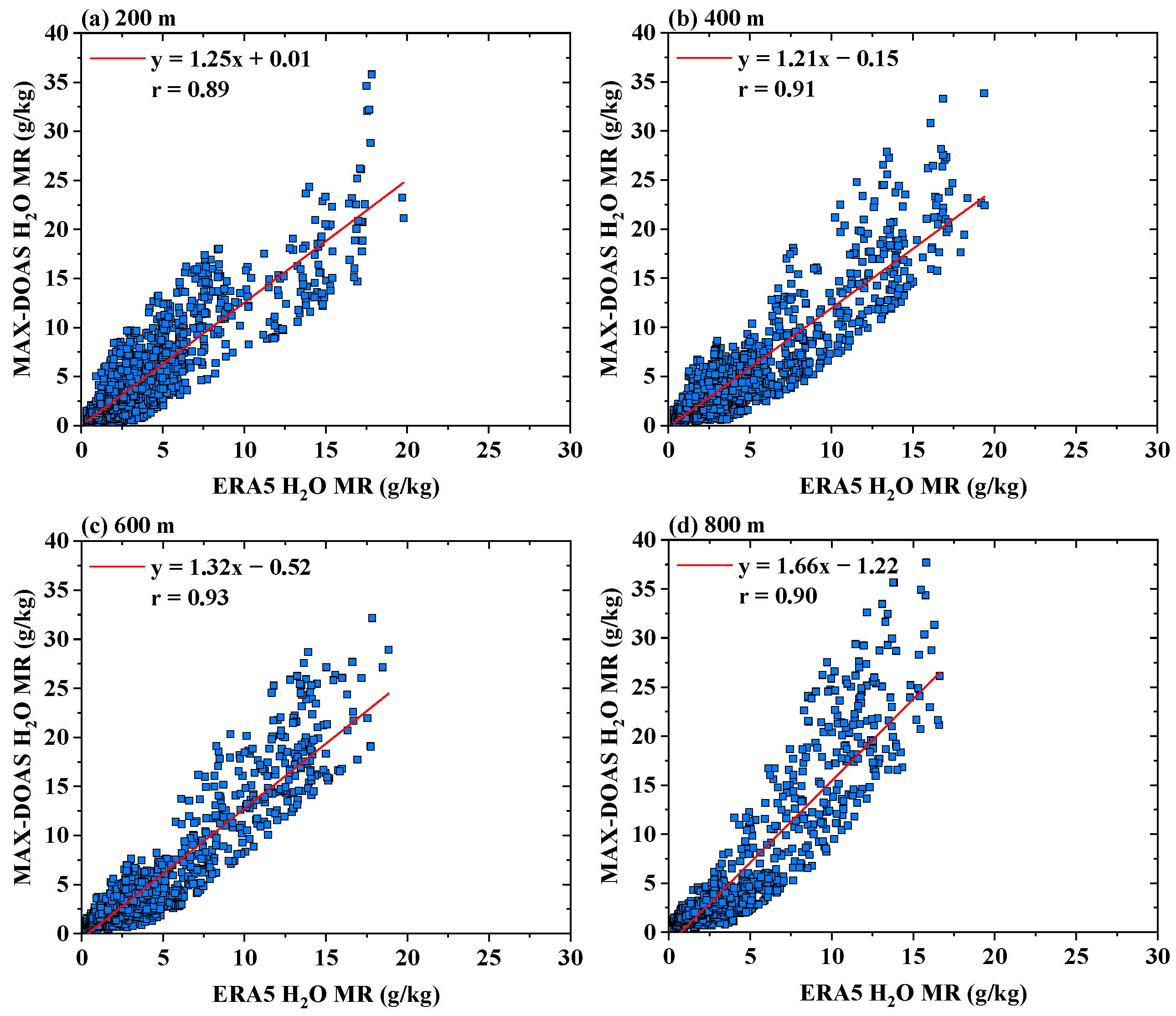
During the observation period, we compared the water vapor mixing ratio concentrations measured at the Beijing MAX-DOAS site with ECMWF ERA5 reanalysis water vapor data. ERA5 is the latest climate reanalysis product from the ECMWF. It integrates extensive historical observations with advanced modeling and data assimilation to provide global estimates of atmospheric, surface, and ocean parameters, along with associated uncertainties. ERA5 offers hourly data at a horizontal resolution of 0.25° × 0.25°, suitable for capturing fine-scale variations. Since MAX-DOAS is particularly sensitive to the lower atmosphere, where water vapor is predominantly concentrated in the lower troposphere, we selected water vapor mixing ratio concentrations at 200 m, 400 m, 600 m, and 800 m for comparison. It is important to note that the vertical dimension in ERA5 is defined by 37 pressure levels, ranging from 1000 hPa (near the surface) to 1 hPa (in the stratosphere). For our analysis, we converted these pressure levels to corresponding geometric altitudes using the standard atmospheric model and then interpolated the water vapor concentrations to the target heights of 200 m, 400 m, 600 m, and 800 m. This approach ensures consistency between the modeled pressure levels and the desired measurement altitudes used in our study. The hourly average comparison results (Figure 5) indicate Pearson’s r values of 0.89, 0.91, 0.93, and 0.90 at 200 m, 400 m, 600 m, and 800 m, respectively, demonstrating good consistency. Additionally, the ERA5 water vapor concentration data are generally lower than those observed by MAX-DOAS (Figure 5), consistent with observations in Qingdao [21]. This discrepancy may be related to differences in spatial and temporal resolution and data processing methods between the two datasets.
Furthermore, the main sources of error in the water vapor flux measurements obtained by this method are associated with DOAS fitting errors, errors in the inversion of water vapor profiles, and uncertainties in the wind field and elevation. The total error is less than 36%. For more details, please refer to the relevant literature [22].
Given that AERONET and ERA5 datasets are derived from long-term, continuous monitoring efforts, their consistency with our one-year MAX-DOAS observations suggests that the observed trends are representative of typical atmospheric conditions in the region. Furthermore, a comparison with 10 years (2014–2023) of ERA5 precipitable water data show similar seasonal trends, with peak values in July and August and the lowest in winter, further supporting the representativeness of our observations (Figures S1 and S2, Supplementary Materials).

3. Results and Discussions

3.1. Precipitable Water Variation

As described in Section 2.2, the tropospheric water vapor VCD output by the PriAM algorithm represents the potential precipitable water, which can be converted into the commonly used unit of precipitation, millimeters (mm). With water resources becoming increasingly scarce, the precise measurement of precipitable water in the Beijing area is critically important for the effective management of water resources, the strategic planning of agriculture, and the adept handling of extreme weather events [27,28]. Using the MAX-DOAS instrument, a year-long observation in the Beijing region provided detailed data on precipitable water (Figure 6). The precipitation volume in the Beijing area markedly increased from June to September, coinciding with the active period of the Asian monsoon system [29,30,31,32]. August observed the zenith of precipitable water, amounting to 39.13 mm, while December and January saw the nadir, registering 4.32 mm and 4.33 mm, respectively. These measurements not only enhance our comprehension of seasonal precipitation patterns but also provide essential data for meteorological models and the prediction of extreme weather events.
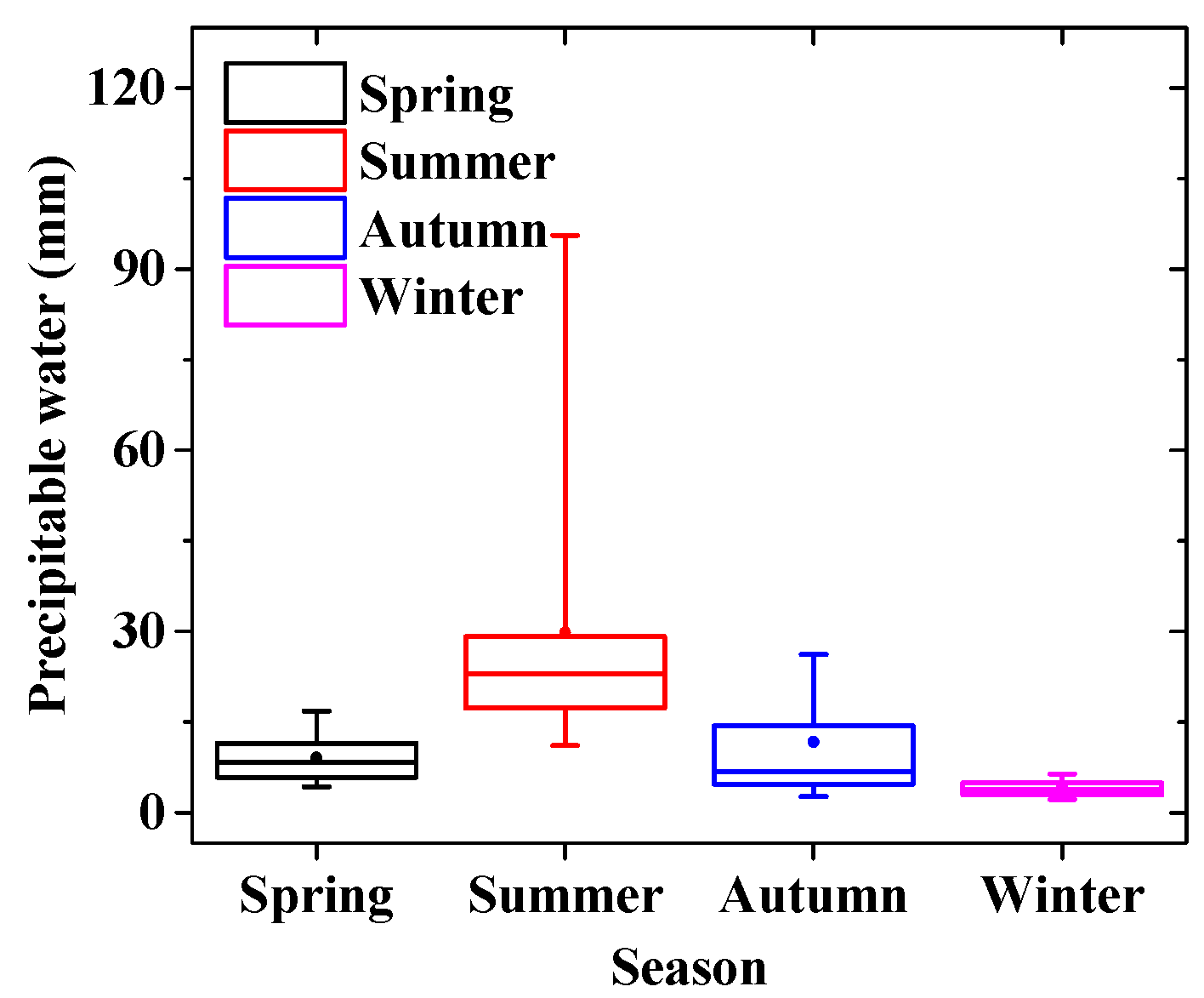
The seasonal distribution of precipitable water in the Beijing region (Figure 7), was statistically analyzed using box plots and bar charts. Precipitable water in Beijing undergoes significant seasonal changes, with the highest average precipitation and the widest range of variability occurring in the summer, which correlates with the frequent occurrence of heavy rainfall during this season. In contrast, the winter season experiences a decrease in precipitable water and the least variability. The mean precipitable water values for the spring, summer, autumn, and winter seasons were 9.10 mm, 29.79 mm, 11.69 mm, and 4.04 mm, respectively. These results were in accordance with the climatic attributes and seasonal precipitation patterns of the Beijing area, which were characterized by wet summers and dry winters.
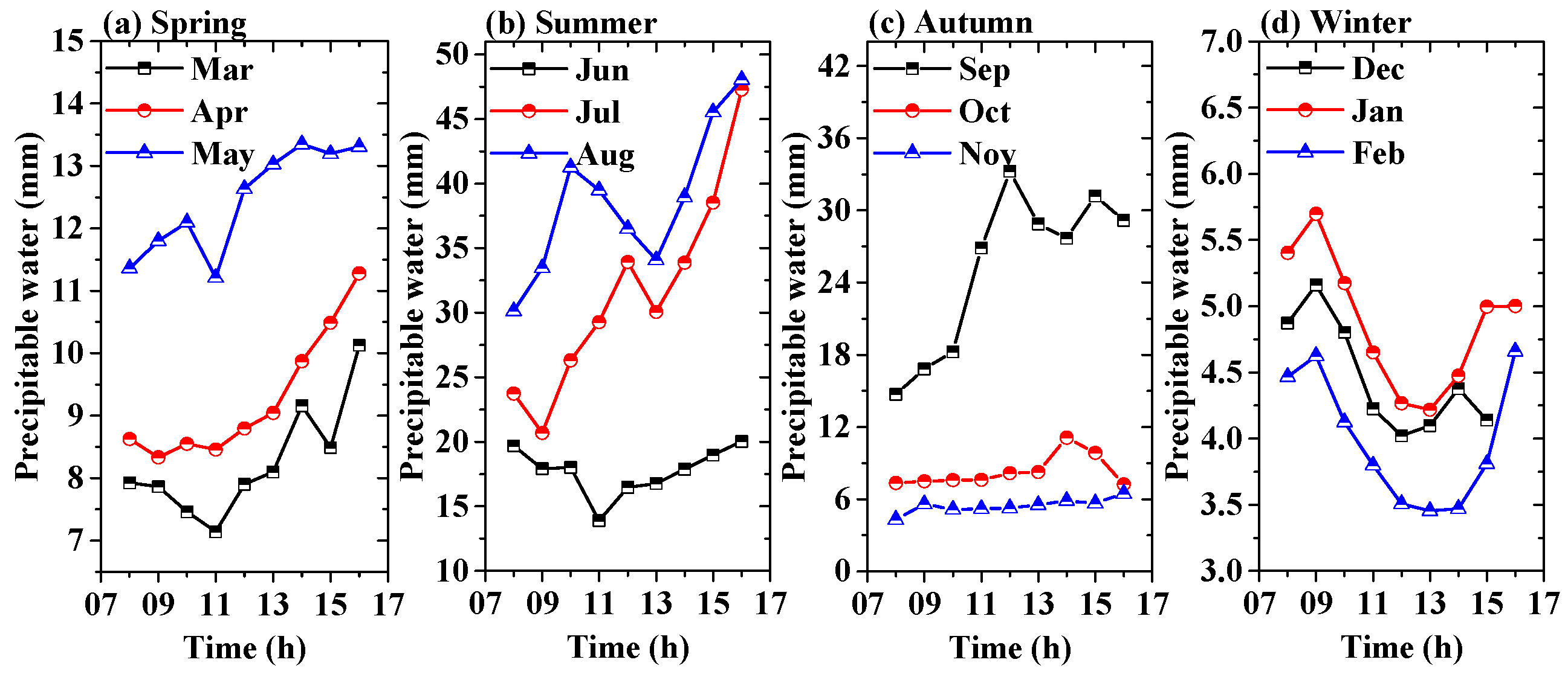
In addition, we have further analyzed the diurnal variation characteristics of the precipitable water in the Beijing area (Figure 8). During the spring, summer, and autumn seasons, the amount of precipitable water tends to increase in the afternoon, which is likely correlated with solar radiation. Solar radiation typically peaks between noon and the early afternoon, leading to a rapid increase in surface temperature and consequently enhancing the evaporation of water vapor from the ground and vegetation into the atmosphere [33]. However, in winter, the pattern of precipitable water exhibits higher levels in the mornings and evenings but lower at midday. This may be attributed to the lower solar radiation and higher humidity levels typical of winter mornings and evenings [34]. Given Beijing’s geographic location in northern China, the winter solar radiation is relatively weak, resulting in less pronounced surface heating, thus inhibiting the evaporation of water vapor in the afternoon. Additionally, in winter, water vapor often condenses into dew or frost overnight, which can lead to higher humidity levels in the air during the early morning and evening hours [34].

3.2. Water Vapor Vertical Distribution and Transport Flux

Investigating the vertical distribution of water vapor offers profound insights into atmospheric conditions and processes and has extensive applications in meteorological, climatic, and environmental research. Using MAX-DOAS instruments, we have obtained the vertical distribution of the atmospheric water vapor mixing ratio from 1 to 4 km in the Beijing area (Figure 9). The results indicated that the concentration of water vapor was mainly concentrated below 2 km. As the altitude increased, the concentration of water vapor generally showed a declining trend, consistent with the overall trend of reduced atmospheric moisture content in high-altitude areas. The concentration of water vapor was higher in summer and lower in winter, especially near the ground, where the feature was more pronounced. From May to September, the water vapor mixing ratio concentration was higher near the surface, with the highest concentration in August, reaching 15.29 g/kg. These results corresponded to the seasonal variations in precipitable water.
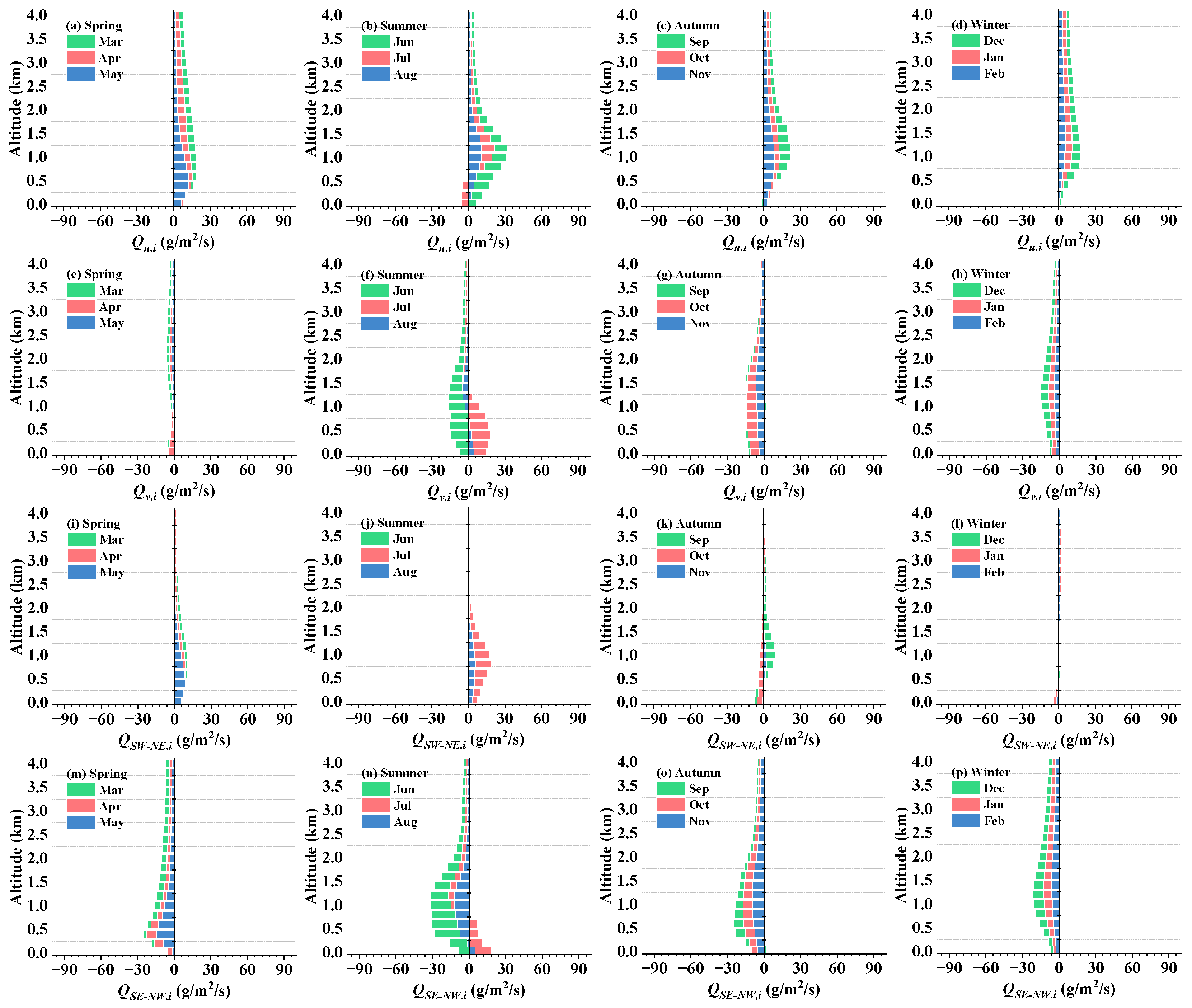
Water vapor flux is a key factor influencing weather systems and precipitation patterns, and analyzing atmospheric water vapor transport flux contributes to the prediction of weather models and understanding of regional water cycles [35]. Following the flux calculation method described in Section 2.3, we calculated the seasonal average vertical distribution of water vapor transport flux in Beijing in the east–west, north–south, southwest–northeast, and southeast–northwest directions (Figure 10). The results reveal that the water vapor transport flux in the Beijing area exhibits significant seasonal and directional characteristics. The results for the east–west direction (Figure 10a–d) indicate that water vapor was predominantly transported eastward. The peak value of water vapor transport occurs at approximately 1.2 km in summer, reaching 31.50 g/m2/s. At lower altitudes in summer, there was a minor westward water vapor transport, particularly in July. The meridional water vapor transport flux (Figure 10e–h) indicated that, except for July in the summer, water vapor was transported southward. In July, the water vapor in the lower atmosphere below 1 km moved north, which may be related to seasonal climate changes and the northward movement of warm air [35,36,37]. Figure 10i–l displays the vertical distribution of water vapor transport flux in the southwest–northeast direction across all four seasons. The results indicate that in spring and summer, water vapor predominantly moved northeast, mainly concentrated below 1.6 km. The peak value of this directional water vapor transport occurred at 0.8 km during summer, reaching 19.01 g/m2/s, signifying northeastward movement. In autumn and winter, the water vapor transport activity was relatively weaker, with a modest amount moving southwestward at lower altitudes and a smaller northeastward movement observed at higher altitudes. The water vapor transport flux from southwest to northeast was the smallest among the directions studied, especially in winter, where it was almost negligible. Figure 10m–p presents the vertical distribution of water vapor transport flux in the southeast–northwest direction throughout the four seasons. It is evident that water vapor mainly moved southeastward in all seasons, with the maximum transport flux occurring at 1.2 km in summer, registering 31.77 g/m2/s. At lower altitudes during summer, a minor northwestward water vapor transport was also observed, albeit with a relatively smaller flux. The water vapor transport flux in the southeast direction was the highest among the directions studied, indicating that the primary direction of transport in the Beijing area is toward the southeast.
The seasonal average results of vertically integrated water vapor transport flux in various directions from 0 to 4 km above the Beijing area (Figure 11a) indicate that the east–west direction maintained positive values in all four seasons, signifying eastward transport from the west. Conversely, the north–south direction consistently shows negative values, indicating a predominant southward movement from the north in all seasons. The southwest–northeast direction recorded positive values in all seasons, representing a southwest-to-northeast transport, while the southeast–northwest direction has negative values, signifying transport from northwest to southeast. The annual average results (Figure 11b) reveal that the highest average total transport occurred in the southeast–northwest direction, with a maximum value of −2.16 × 10⁴ g/m/s. This indicates a predominant southeastward movement of water vapor, likely due to the combined effects of west-to-east and north-to-south water vapor transport. In the east–west and north–south directions, the annual average values of vertically integrated water vapor transport flux were 2.09 × 10⁴ g/m/s (indicating eastward transport) and −0.96 × 10⁴ g/m/s (indicating southward transport), respectively. However, the flux was smallest in the southwest–northeast direction, at just 0.79 × 10⁴ g/m/s, denoting northeastward transport. This value was only 36.57% of the transport flux in the southeast–northwest direction.
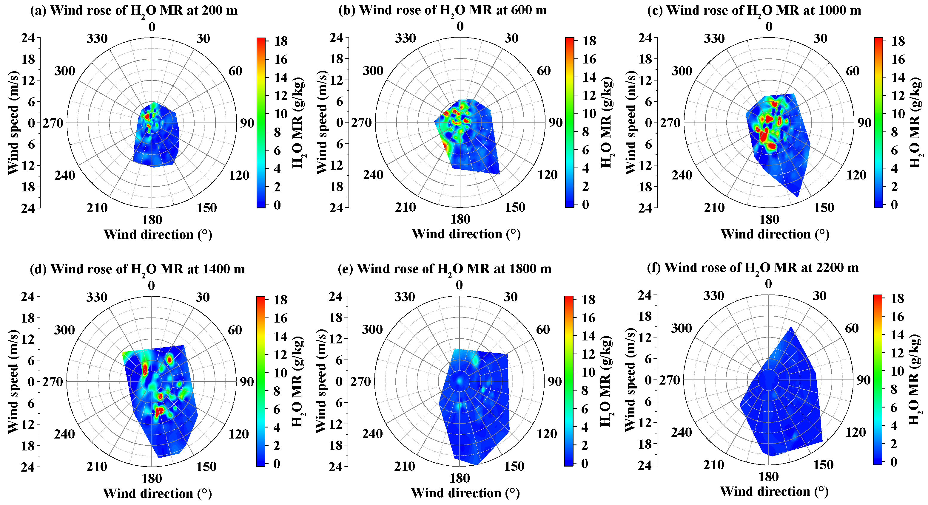
Additionally, wind rose diagrams depicting water vapor concentrations at different altitudes were created using ECMWF ERA5 wind field data and water vapor profiles measured by MAX-DOAS (Figure 12). It should be noted that in Figure 12, the wind direction (°) indicates the direction toward which the wind is blowing. The results indicated that the prevailing wind direction in the Beijing area was predominantly southeast, originating from the northwest. The strongest winds were also concentrated in the southeast direction (approximately 120° to 180°) and increased with altitude, facilitating the transport of water vapor southeastward at higher elevations. At lower altitudes of 200 m and 600 m, higher water vapor concentrations appeared in the western and northern parts of the diagram, suggesting that winds blowing from the southeast in the boundary layer carried more moisture. Additionally, at a near-surface height of 200 m, high water vapor values were concentrated in areas with lower wind speeds (less than 3 m/s). This was due to the difficulty of water vapor dispersing under low wind speed conditions, leading to accumulation near the ground [38]. At altitudes of 600 m and 1000 m, high water vapor concentrations in the southwestern parts of the diagrams were accompanied by higher wind speeds, indicating that moist air from the northeast could be transported to Beijing at heights between 600 m and 1000 m under higher wind speeds. Furthermore, at an altitude of 1400 m, the southeastern sector also exhibited characteristics of high wind speeds and high water vapor concentrations, associated with upper-level northwestern wind transport. Overall, there are distinct areas of high water vapor concentration from 200 m to 1400 m, whereas at higher altitudes (1800 m and 2200 m), the concentration of water vapor is relatively lower, with no significant high-value areas. Compared to the 200 m wind rose, the high-value regions of water vapor content at 600 m, 1000 m, and 1400 m altitudes were more dispersed and uniform, possibly due to more complex atmospheric layering or local climatic characteristics [39]. At 1400 m, high water vapor concentrations were observed in the directions of 45°, 165°, and 330°, with wind speeds within the range of 3–8 m/s. These results are of significant reference value for meteorological forecasting, climate research, water resource management, and environmental monitoring.

3.3. Water Vapor Variation Before Precipitation

Precipitation is a key component of the water cycle and is closely linked to water vapor transport. It not only reflects changes in climate patterns, but also intense precipitation can even lead to flooding disasters [40]. Using MAX-DOAS technology for real-time monitoring of water vapor in urban areas not only enhances the understanding of small-scale meteorological phenomena, but also allows for the analysis of anomalies in water vapor flux and precipitable water before rainfall through the collection of long-term data. This is extremely valuable for the early identification and prediction of rainfall events.
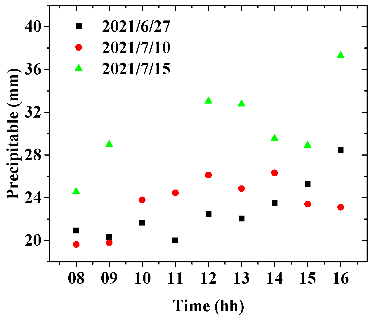
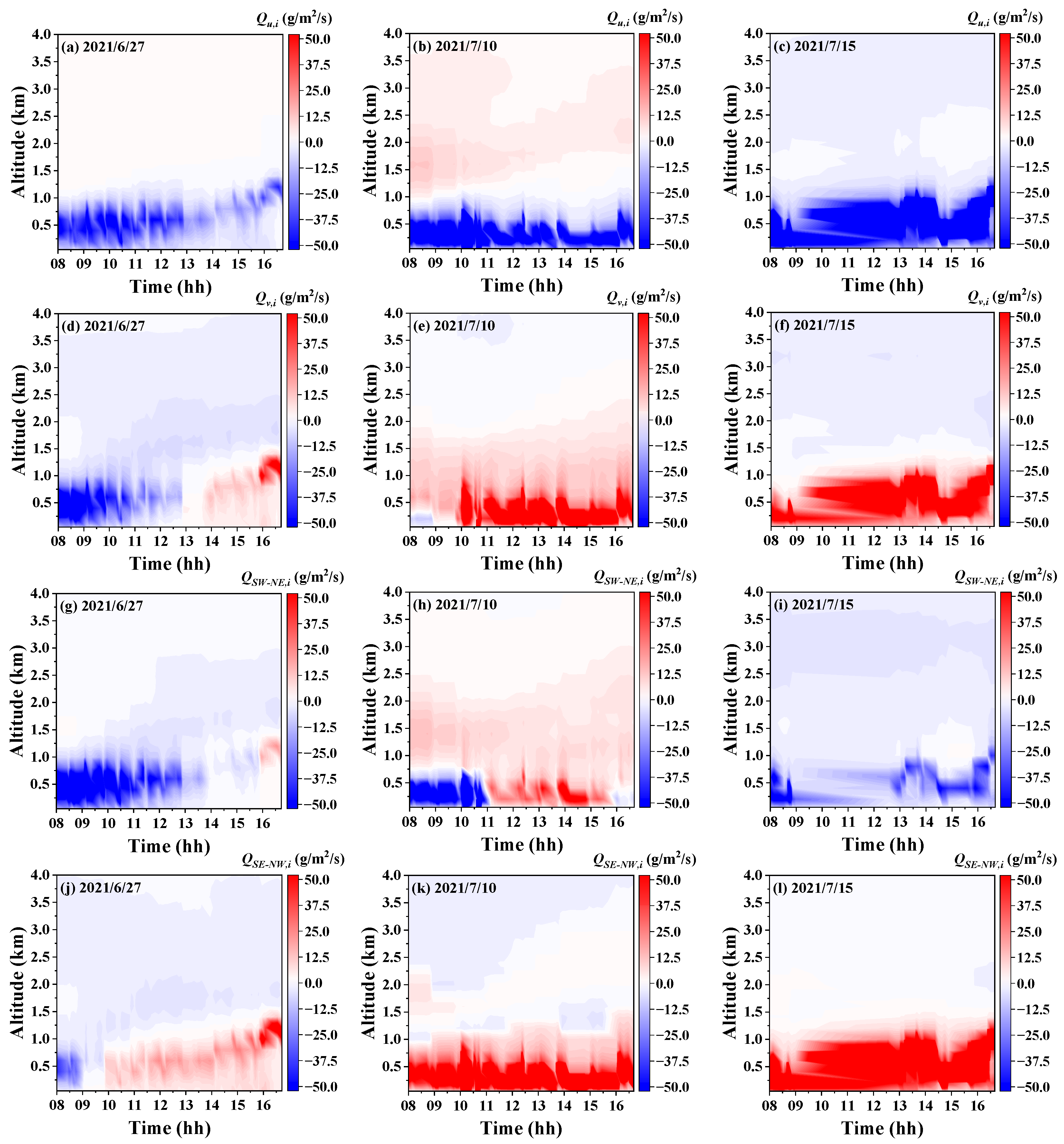
Based on historical meteorological data from Beijing (http://data.cma.cn/ (accessed on 20 May 2024)), the day preceding consecutive rainfall events (lasting three days or more) during the study period was selected to analyze the diurnal variation of precipitable water (Figure 13) and changes in water vapor flux from different directions (Figure 14). On the day before rainfall, precipitable water levels in Beijing showed a rising trend, which was similar to the results of these previous reports [22,41]. The vapor transport before the three rainfall events was concentrated below 1 km, and the direction of transport was similar across these three days. The water vapor transport flux below 1 km was negative in the east–west direction (Figure 14a–c), indicating westward transport, which suggested that the water vapor originated from the eastern region before rainfall. The water vapor transport flux below 1 km turned positive in the north–south direction (Figure 14d–f), indicating northward transport, suggesting that the water vapor came from the southern region before rainfall. The water vapor transport flux in the southwest–northeast direction before rainfall did not follow a consistent pattern and the flux was relatively small (Figure 14g–i). Regarding the water vapor transport flux in the southeast–northwest direction before rainfall (Figure 14j–l) below 1 km was consistently positive, indicating northwestward transport. This suggested that the water vapor originated from the southeast before rainfall, aligning with the conclusions drawn from the east–west direction (Figure 14a–c) and the north–south direction (Figure 14d–f).
In summary, before consecutive rainfall events in the Beijing area, water vapor primarily originates from the southeast, which is consistent with the conclusions of previous studies that used satellite methods [42]. This directional flow of water vapor created favorable climatic conditions for precipitation. This phenomenon is closely tied to Beijing’s unique geographical environment: the region is surrounded by mountains to the west, north, and northeast, while the southeast opens up to the plains leading to the Bohai Sea. On the one hand, southeast winds brings warm and moist marine air inland. When this air reaches Beijing and encounters cold air from the northwest, it is forced to rise and cool, thus potentially triggering precipitation [43]. On the other hand, when moist air flows reached the mountain ranges to the northwest of Beijing, they were also forced upward, causing the air to cool and condense, further increasing the likelihood of rainfall.

3.4. Backward Trajectory Analysis

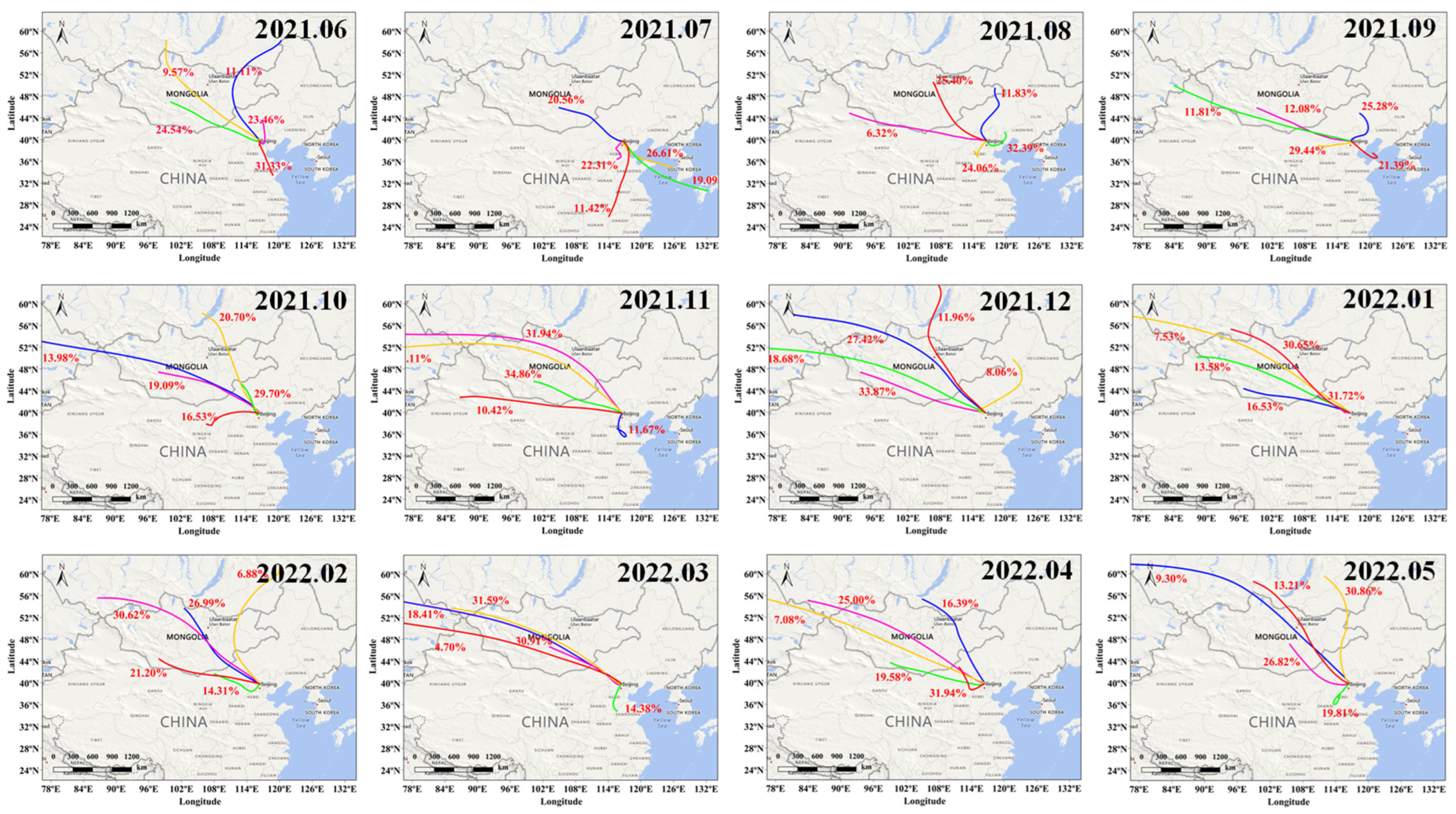
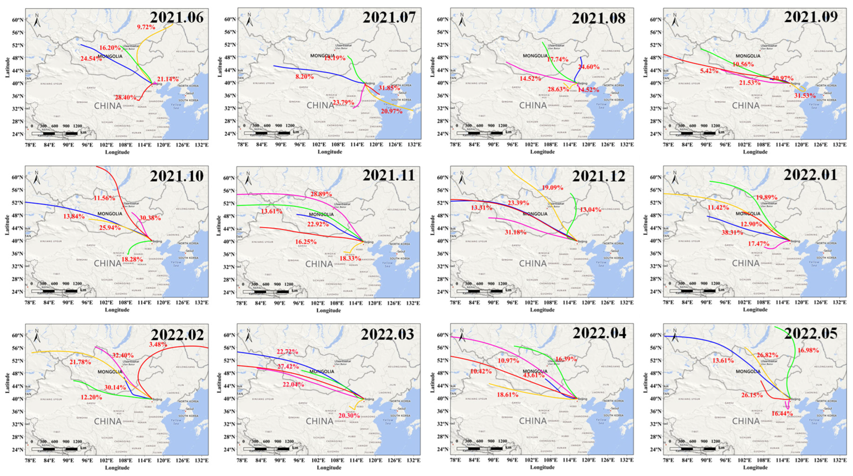
Water vapor has a prolonged residence time in the atmosphere, enabling long-distance transport. The analysis of air mass backward trajectories is instrumental in determining the propagation paths of air masses and water vapor, which is crucial for understanding how water vapor reaches specific regions. In this study, we utilized the HYSPLIT model to track the backward trajectories of air masses at various altitudes (500 m, 1000 m, and 1500 m) over 72 h (Figure 15, Figure 16 and Figure 17). The analysis indicated that the characteristics of air mass transport at these three altitudes were generally consistent across different months, with northwest directional transport being more pronounced than in other directions. During the rainy months from June to September, a higher proportion of southeast winds was observed. Specifically, at an altitude of 500 m, the proportion of southeast winds in June, July, August, and September was 58.26%, 85.34%, 68.82%, and 62.08%, respectively. At altitudes of 1000 m and 1500 m, the proportions for the same months were 31.33%, 79.43%, 56.45%, 21.39%, and 49.54%, 76.61%, 43.15%, 31.53%, respectively. It is evident that at the lower altitude of 500 m, a higher proportion of southeast air masses was recorded, indicating that southeast-directed water vapor primarily travels along lower altitudinal layers. In other months, northwest winds dominate, with faster speeds and longer transport distances, aligning with observations in Figure 10 that indicated a greater amount of water vapor transport from the northwest direction.
Additionally, we analyzed the data from the day preceding each precipitation event observed during the study period and tracked the 72 h backward trajectories (Figure 18) of air masses at three different altitudes (500 m, 1000 m, 1500 m). The results revealed that before precipitation, the largest transport of air masses at a low altitude (500 m) was from the southeast direction, accounting for 69.11% of the total, primarily originating from the Bohai Bay and Yellow Sea areas. At higher altitudes, the predominant air masses were transported from the northwest. Due to the reduction in water vapor concentration at higher altitudes, moisture transport remains concentrated in the lower layers, meaning that water vapor was primarily transported by the lower-level southeasterly winds. This finding aligns with the observations in Figure 14, which noted that the predominant source of moisture before rainfall was from the southeast and concentrated below an altitude of 1000 m.

4. Conclusions

The study of the spatiotemporal distribution and multidirectional transport of water vapor in the Beijing area is crucial for understanding and managing urban extreme precipitation, climate change, and water resource planning. Utilizing MAX-DOAS technology, we conducted a year-long observational study that provided detailed insights into the behavior of atmospheric water vapor within an urban environment.
Our results indicate that precipitable water in the Beijing area increases from June to mid-October, with the highest value observed in August (39.13 mm). The vertical distribution of the water vapor mixing ratio from 0 to 4 km generally decreases with altitude. The transport flux of water vapor in Beijing reaches its peak during the summer, with the maximum transport occurring toward the southeast direction, while the smallest transport flux occurs in the southwest–northeast direction. Analysis of vertically integrated water vapor transport flux reveals similar seasonal patterns, closely associated with prevailing wind patterns. The maximum water vapor transport flux occurs at an altitude of 1.2 km during the summer, with a value of 31.77 g/m2/s, transported towards the southeast. Additionally, we found that at altitudes below 600 m, high water vapor values often accompany southeast winds and lower wind speeds (<3 m/s). Additionally, we analyzed the dynamics of water vapor before continuous rainfall events (lasting three days or more) in the Beijing area. Our findings show an increasing trend in precipitable water before rainfall, with the main source of water vapor coming from the southeast, creating favorable climatic conditions for precipitation. Lastly, Backward trajectory analysis indicates that before precipitation, air masses from the southeast at a low altitude of 500 m represent 69.11% of the total, primarily originating from the Bohai Bay and Yellow Sea areas.
This study demonstrates the potential and effectiveness of MAX-DOAS in remote sensing of atmosphere water vapor. These results not only provide important data on the transport and distribution of water vapor in Beijing but also hold significant scientific and practical implications for predicting and understanding the region’s climate changes and extreme weather events.

Supplementary Materials

The following supporting information can be downloaded at: https://www.mdpi.com/article/10.3390/atmos15101253/s1, Figure S1: ERA5 monthly distribution of precipitable water in the most recent ten years (2014–2023); Figure S2: Comparison between MAX-DOAS and long-term ERA5 data (a) comparison of trends; (b) correlation analysis.

Author Contributions

Data curation, H.R., A.L., H.Z., J.X. and S.W.; formal analysis, H.R.; funding acquisition, H.R.; methodology, H.R.; resources, S.W.; software, A.L. and Z.H.; supervision, A.L. and Z.H.; validation, H.Z. and J.X.; writing—original draft, H.R.; writing—review and editing, A.L. All authors have read and agreed to the published version of the manuscript.

Funding

This research was funded by the National Natural Science Foundation of China (No.: 42405135), the National Key Research and Development Project of China (No.: 2022YFC3703502, 2018YFC0213201), and the Local Service Project of Hefei (No.: 2020BFFFD01804).

Institutional Review Board Statement

Not applicable.

Informed Consent Statement

Not applicable.

Data Availability Statement

The original contributions presented in the study are included in the article/Supplementary Materials, further inquiries can be directed to the corresponding author/s.

Acknowledgments

We thank the Belgian Institute for Space Aeronomy (BIRAIASB), Brussels, Belgium, for their freely accessible QDOAS software. We are grateful to ECMWF and AERONET for providing free data resources.

Conflicts of Interest

The authors declare no conflicts of interest.

References

  1. Allan, R.P. The role of water vapour in Earth’s energy flows. Surv. Geophys. 2012, 33, 557–564. [Google Scholar] [CrossRef]
  2. Salamalikis, V.; Vamvakas, I.; Gueymard, C.A.; Kazantzidis, A. Atmospheric water vapor radiative effects on shortwave radiation under clear skies: A global spatiotemporal analysis. Atmos. Res. 2021, 251, 105418. [Google Scholar] [CrossRef]
  3. Sun, L.; Shen, B.; Sui, B. A study on water vapor transport and budget of heavy rain in Northeast China. Adv. Atmos. Sci. 2010, 27, 1399–1414. [Google Scholar] [CrossRef]
  4. Kim, Y.-J.; Jee, J.-B.; Lim, B. Investigating the Influence of Water Vapor on Heavy Rainfall Events in the Southern Korean Peninsula. Remote Sens. 2023, 15, 340. [Google Scholar] [CrossRef]
  5. Du, R.; Song, J.; Huang, X.; Wang, Q.; Zhang, C.; Brousse, O.; Chan, P.W. High-resolution regional modeling of urban moisture island: Mechanisms and implications on thermal comfort. Build. Environ. 2022, 207, 108542. [Google Scholar] [CrossRef]
  6. Huang, X.; Swain, D.L.; Hall, A.D. Future precipitation increase from very high resolution ensemble downscaling of extreme atmospheric river storms in California. Sci. Adv. 2020, 6, eaba1323. [Google Scholar] [CrossRef]
  7. Ssenyunzi, R.C.; Oruru, B.; D’ujanga, F.M.; Realini, E.; Barindelli, S.; Tagliaferro, G.; von Engeln, A.; van de Giesen, N. Performance of ERA5 data in retrieving Precipitable Water Vapour over East African tropical region. Adv. Space Res. 2020, 65, 1877–1893. [Google Scholar] [CrossRef]
  8. Zheng, Z.; Xu, G.; Gao, H. Characteristics of Summer Hourly Extreme Precipitation Events and Its Local Environmental Influencing Factors in Beijing under Urbanization Background. Atmosphere 2021, 12, 632. [Google Scholar] [CrossRef]
  9. Zhao, D.; Xu, H.; Li, Y.; Yu, Y.; Duan, Y.; Xu, X.; Chen, L. Locally opposite responses of the 2023 Beijing–Tianjin–Hebei extreme rainfall event to global anthropogenic warming. NPJ Clim. Atmos. Sci. 2024, 7, 38. [Google Scholar] [CrossRef]
  10. Zhang, M.; Zhang, Y.; Tian, Y.; Xie, D.; Cao, Y.; Mei, Y.; Li, T.; Wang, G.; Zhong, D. On the moisture transport regimes for extreme precipitation over North China. Atmos. Res. 2024, 300, 107254. [Google Scholar] [CrossRef]
  11. Song, X.; Tang, Y.; Zhang, Y.; Ma, Y.; Han, D.; Bu, H.; Yang, L.; Liu, F. Using stable isotopes to study vapor transport of continuous precipitation in Beijing. Adv. Water Sci. 2017, 28, 488–495. [Google Scholar]
  12. Jiang, X.; Li, J.; Li, Z.; Xue, Y.; Li, J. Evaluation of Environmental Moisture from NWP Models with Measurements from Advanced Geostationary Satellite Imager—A Case Study. Remote Sens. 2020, 12, 670. [Google Scholar] [CrossRef]
  13. Trent, T.; Schroeder, M.; Remedios, J. GEWEX Water Vapor Assessment: Validation of AIRS Tropospheric Humidity Profiles With Characterized Radiosonde Soundings. J. Geophys. Res. Atmos. 2019, 124, 886–906. [Google Scholar] [CrossRef]
  14. Trent, T.; Siddans, R.; Kerridge, B.; Schroder, M.; Scott, N.A.; Remedios, J. Evaluation of tropospheric water vapour and temperature profiles retrieved from MetOp-A by the Infrared and Microwave Sounding scheme. Atmos. Meas. Tech. 2023, 16, 1503–1526. [Google Scholar] [CrossRef]
  15. Carroll, B.J.; Nehrir, A.R.; Kooi, S.A.; Collins, J.E.; Barton-Grimley, R.A.; Notari, A.; Harper, D.B.; Lee, J. Differential absorption lidar measurements of water vapor by the High Altitude Lidar Observatory (HALO): Retrieval framework and first results. Atmos. Meas. Tech. 2022, 15, 605–626. [Google Scholar] [CrossRef]
  16. Sapucci, L.F.; Machado, L.A.T.; de Souza, E.M.; Campos, T.B. Global Positioning System precipitable water vapour (GPS-PWV) jumps before intense rain events: A potential application to nowcasting. Meteorol. Appl. 2019, 26, 49–63. [Google Scholar] [CrossRef]
  17. Dimitropoulou, E.; Hendrick, F.; Friedrich, M.M.; Tack, F.; Pinardi, G.; Merlaud, A.; Fayt, C.; Hermans, C.; Fierens, F.; Van Roozendael, M. Horizontal distribution of tropospheric NO2 and aerosols derived by dual-scan multi-wavelength multi-axis differential optical absorption spectroscopy (MAX-DOAS) measurements in Uccle, Belgium. Atmos. Meas. Tech. 2022, 15, 4503–4529. [Google Scholar] [CrossRef]
  18. Qian, Y.; Luo, Y.; Dou, K.; Zhou, H.; Xi, L.; Yang, T.; Zhang, T.; Si, F. Retrieval of tropospheric ozone profiles using ground-based MAX-DOAS. Sci. Total Environ. 2023, 857, 159341. [Google Scholar] [CrossRef]
  19. Ryan, R.G.; Marais, E.A.; Gershenson-Smith, E.; Ramsay, R.; Muller, J.-P.; Tirpitz, J.-L.; Friess, U. Measurement report: MAX-DOAS measurements characterise Central London ozone pollution episodes during 2022 heatwaves. Atmos. Chem. Phys. 2023, 23, 7121–7139. [Google Scholar] [CrossRef]
  20. Lin, H.; Liu, C.; Xing, C.; Hu, Q.; Hong, Q.; Liu, H.; Li, Q.; Tan, W.; Ji, X.; Wang, Z.; et al. Validation of Water Vapor Vertical Distributions Retrieved from MAX-DOAS over Beijing, China. Remote Sens. 2020, 12, 3193. [Google Scholar] [CrossRef]
  21. Ren, H.; Li, A.; Xie, P.; Hu, Z.; Xu, J.; Huang, Y.; Li, X.; Zhong, H.; Tian, X.; Ren, B.; et al. Investigation of the Influence of Water Vapor on Heavy Pollution and Its Relationship With AOD Using MAX-DOAS on the Coast of the Yellow Sea. J. Geophys. Res. Atmos. 2021, 126, e2020JD034143. [Google Scholar] [CrossRef]
  22. Ren, H.; Li, A.; Xie, P.; Hu, Z.; Xu, J.; Huang, Y.; Li, X.; Zhong, H.; Tian, X.; Ren, B.; et al. Estimation of the Precipitable Water and Water Vapor Fluxes in the Coastal and Inland Cities of China Using MAX-DOAS. Remote Sens. 2021, 13, 1675. [Google Scholar] [CrossRef]
  23. Lampel, J.; Poehler, D.; Tschritter, J.; Friess, U.; Platt, U. On the relative absorption strengths of water vapour in the blue wavelength range. Atmos. Meas. Tech. 2015, 8, 4329–4346. [Google Scholar] [CrossRef]
  24. Wang, Y.; Apituley, A.; Bais, A.; Beirle, S.; Benavent, N.; Borovski, A.; Bruchkouski, I.; Chan, K.L.; Donner, S.; Drosoglou, T.; et al. Inter-comparison of MAX-DOAS measurements of tropospheric HONO slant column densities and vertical profiles during the CINDI-2 campaign. Atmos. Meas. Tech. 2020, 13, 5087–5116. [Google Scholar] [CrossRef]
  25. Zhang, H.; Li, A.; Hu, Z.; Guo, J.; Yun, L.; Zhang, M.; Ren, H.; Zhong, H.; Xu, J. Evaluation and measurement of tropospheric glyoxal retrieved from MAX-DOAS in Shenzhen, China. Sci. Total Environ. 2023, 878, 162727. [Google Scholar] [CrossRef]
  26. Wang, Y.; Lampel, J.; Xie, P.; Beirle, S.; Li, A.; Wu, D.; Wagner, T. Ground-based MAX-DOAS observations of tropospheric aerosols, NO2, SO2 and HCHO in Wuxi, China, from 2011 to 2014. Atmos. Chem. Phys. 2017, 17, 2189–2215. [Google Scholar] [CrossRef]
  27. Qiao, C.; Liu, S.; Huo, J.; Mu, X.; Wang, P.; Jia, S.; Fan, X.; Duan, M. Retrievals of precipitable water vapor and aerosol optical depth from direct sun measurements with EKO MS711 and MS712 spectroradiometers. Atmos. Meas. Tech. 2023, 16, 1539–1549. [Google Scholar] [CrossRef]
  28. Yan, Y.; Miao, Y.; Guo, J.; Liu, S.; Liu, H.; Lou, M.; Liu, L.; Chen, D.; Xue, W.; Zhai, P. Synoptic patterns and sounding-derived parameters associated with summertime heavy rainfall in Beijing. Int. J. Climatol. 2019, 39, 1476–1489. [Google Scholar] [CrossRef]
  29. Fu, J.; Zhang, F.; Hewson, T.D. Object-Oriented Composite Analysis of Warm-Sector Rainfall in North China. Mon. Weather Rev. 2020, 148, 2719–2735. [Google Scholar] [CrossRef]
  30. Song, X.; Zou, X.; Mo, Y.; Zhang, J.; Zhang, C.; Tian, Y. Nonstationary bayesian modeling of precipitation extremes in the Beijing-Tianjin-Hebei Region, China. Atmos. Res. 2020, 242, 105006. [Google Scholar] [CrossRef]
  31. Ullah, W.; Karim, A.; Ullah, S.; Rehman, A.-U.; Bibi, T.; Wang, G.; Ullah, S.; Bhatti, A.S.; Ali, G.; Abbas, A.; et al. An increasing trend in daily monsoon precipitation extreme indices over Pakistan and its relationship with atmospheric circulations. Front. Environ. Sci. 2023, 11, 1228817. [Google Scholar] [CrossRef]
  32. Gong, S.; Hagan, D.F.; Wu, X.; Wang, G.J.I.J.o.R.S. Spatio-temporal analysis of precipitable water vapour over northwest china utilizing MERSI/FY-3A products. Int. J. Remote Sens. 2018, 39, 3094–3110. [Google Scholar] [CrossRef]
  33. Li, Z.; Abulikemu, A.; Zhu, K.; Mamtimin, A.; Zeng, Y.; Li, J.; Abulimiti, A.; Kadier, Z.; Abuduaini, A.; Li, C.; et al. Diurnal Variation Characteristics of Summer Precipitation and Related Statistical Analysis in the Ili Region, Xinjiang, Northwest China. Remote Sens. 2023, 15, 3954. [Google Scholar] [CrossRef]
  34. Ryu, Y.-H.; Smith, J.A.; Bou-Zeid, E. On the Climatology of Precipitable Water and Water Vapor Flux in the Mid-Atlantic Region of the United States. J. Hydrometeorol. 2015, 16, 70–87. [Google Scholar] [CrossRef]
  35. Chen, Y.; Wen, J.; Liu, R.; Zhou, J.; Liu, W. The Characteristics of Water Vapor Transport and Its Linkage with Summer Precipitation over the Source Region of the Three Rivers. J. Hydrometeorol. 2022, 23, 441–455. [Google Scholar] [CrossRef]
  36. Wang, H.; Zhao, P. Diurnal Characteristics in Summer Water Vapor Budget and Transport over the Tibetan Plateau. Atmosphere 2023, 14, 322. [Google Scholar] [CrossRef]
  37. Zhang, R.; Chu, Q.; Zuo, Z.; Qi, Y. Summertime Moisture Sources and Transportation Pathways for China and Associated Atmospheric Circulation Patterns. Front. Earth Sci. 2021, 9, 756943. [Google Scholar] [CrossRef]
  38. Ren, Y.; Zhang, H.; Zhang, X.; Wei, W.; Li, Q.; Wu, B.; Cai, X.; Song, Y.; Kang, L.; Zhu, T. Turbulence barrier effect during heavy haze pollution events. Sci. Total Environ. 2021, 753, 142286. [Google Scholar] [CrossRef]
  39. Lou, H.; Zhang, J.; Yang, S.; Cai, M.; Ren, X.; Luo, Y.; Li, C. Exploring the Relationships of Atmospheric Water Vapor Contents and Different Land Surfaces in a Complex Terrain Area by Using Doppler Radar. Atmosphere 2021, 12, 528. [Google Scholar] [CrossRef]
  40. Bedka, K.M.; Nehrir, A.R.; Kavaya, M.; Barton-Grimley, R.; Beaubien, M.; Carroll, B.; Collins, J.; Cooney, J.; Emmitt, G.D.; Greco, S.; et al. Airborne lidar observations of wind, water vapor, and aerosol profiles during the NASA Aeolus calibration and validation (Cal/Val) test flight campaign. Atmos. Meas. Tech. 2021, 14, 4305–4334. [Google Scholar] [CrossRef]
  41. Oigawa, M.; Realini, E.; Tsuda, T. Study of Water Vapor Variations Associated with Meso-γ Scale Convection: Comparison between GNSS and Non-Hydrostatic Model Data. SOLA—Sci. Online Lett. Atmos. 2015, 11, 27–30. [Google Scholar] [CrossRef]
  42. Jin, M.S.; Li, Y.; Su, D. Urban-Induced Mechanisms for an Extreme Rainfall Event in Beijing China: A Satellite Perspective. Climate 2015, 3, 193–209. [Google Scholar] [CrossRef]
  43. Kebacho, L.L. Climatological characteristics and interannual variability of the leading mode of eastern African precipitation in January and February. Int. J. Climatol. 2024, 44, 1371–1390. [Google Scholar] [CrossRef]
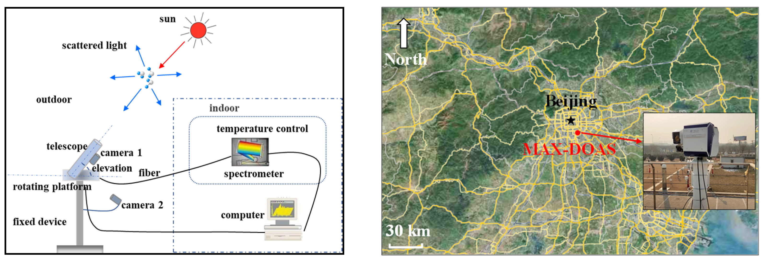
Figure 1. The schematic diagram (left) and location (right) of the multi-axis differential optical absorption spectroscopy (MAX-DOAS) instrument.
Atmosphere 15 01253 g001
Figure 2. Examples of typical DOAS fits of O4 and H2O at 10:55:15 a.m. local time (LT) on 14 May 2022.
Atmosphere 15 01253 g002
Figure 3. The illustration of the directions of the wind speeds calculated in this paper (u represents the zonal wind, v represents the meridional wind, W S W N E represents the southwest–northeast wind, and W S E N W represents the southeast–northwest wind).
Atmosphere 15 01253 g003
Figure 4. Comparison of hourly average precipitable water measurements between MAX-DOAS and AERONET: (a) time series analysis; (b) correlation analysis.
Atmosphere 15 01253 g004
Figure 5. Comparison of Water Vapor Mixing Ratio Concentrations between MAX-DOAS and ERA5: (a) 200 m; (b) 400 m; (c) 600 m; (d) 800 m.
Atmosphere 15 01253 g005
Figure 6. Monthly average distribution of precipitable water.
Atmosphere 15 01253 g006
Figure 7. Seasonal distribution box plot of precipitable water. The central black line on each box indicates the median, the central black circle on each box indicates the mean, and the bottom (top) edge of each box indicates the 25th (75th) percentile. The vertical bars represent the range from the 5th to the 95th percentiles of the data.
Atmosphere 15 01253 g007
Figure 8. Diurnal variation of precipitable water.
Atmosphere 15 01253 g008
Figure 9. Vertical distribution of water vapor mixing ratio concentrations by month.
Atmosphere 15 01253 g009
Figure 10. Seasonal vertical distribution of water vapor transport flux in different directions: (ad) east–west direction; (eh) north–south direction; (il) southwest–northeast direction; (mp) southeast–northwest direction.
Atmosphere 15 01253 g010
Figure 11. Seasonal and annual average distributions of vertically integrated water vapor transport flux in various directions: (a) seasonal average distribution; (b) annual average distribution.
Atmosphere 15 01253 g011
Figure 12. Wind speed and direction, along with H2O MR at different altitudes: (a) at 200 m; (b) at 600 m; (c) at 1000 m; (d) at 1400 m; (e) at 1800 m; (f) at 2200 m.
Atmosphere 15 01253 g012
Figure 13. Distribution of precipitable water in the Beijing area before rainfall.
Atmosphere 15 01253 g013
Figure 14. Vertical distribution of water vapor transport flux before rainfall: (ac) East-West direction; (df) North-South direction; (gi) Southwest-Northeast direction; (jl) Southeast-Northwest direction.
Atmosphere 15 01253 g014
Figure 15. 72 h backward trajectories of air masses at an altitude of 500 m from June 2021 to May 2022, across different months.
Atmosphere 15 01253 g015
Figure 16. 72 h backward trajectories of air masses at an altitude of 1000 m from June 2021 to May 2022, across different months.
Atmosphere 15 01253 g016
Figure 17. 72 h backward trajectories of air masses at an altitude of 1500 m from June 2021 to May 2022, across different months.
Atmosphere 15 01253 g017
Figure 18. Statistical results of the 72 h backward trajectories of air masses from the day before precipitation during the observation period at (a) 500 m, (b) 1000 m, and (c) 1500 m.
Atmosphere 15 01253 g018
Table 1. Some model input parameters for water vapor retrieval using PriAM (jointly developed by the Anhui Institute of Optics and Fine Mechanics and the Max Planck Institute of Chemistry).
Parameter NameParameter Value
Instrument elevation1°, 2°, 3°, 4°, 5°, 6°, 8°, 10°, 20°, 30°, 90°
Instrument azimuth149°
Asymmetric factor0.66
Prior profile covariance Matrix0.3
Single scattered albedo0.91
Maximum iterations10
Aerosol modeling wavelength360 nm
Water vapor simulation wavelength442 nm
Disclaimer/Publisher’s Note: The statements, opinions and data contained in all publications are solely those of the individual author(s) and contributor(s) and not of MDPI and/or the editor(s). MDPI and/or the editor(s) disclaim responsibility for any injury to people or property resulting from any ideas, methods, instructions or products referred to in the content.