
The Status of Space Weather Infrastructure and Research in Africa


 ,
,  , , , , ,
  ,
,
Abstract
1. Introduction
1.1. What Is Space Weather?
1.2. The African Context
2. Distribution of Space Weather Infrastructure in Africa
2.1. Space Weather Monitoring
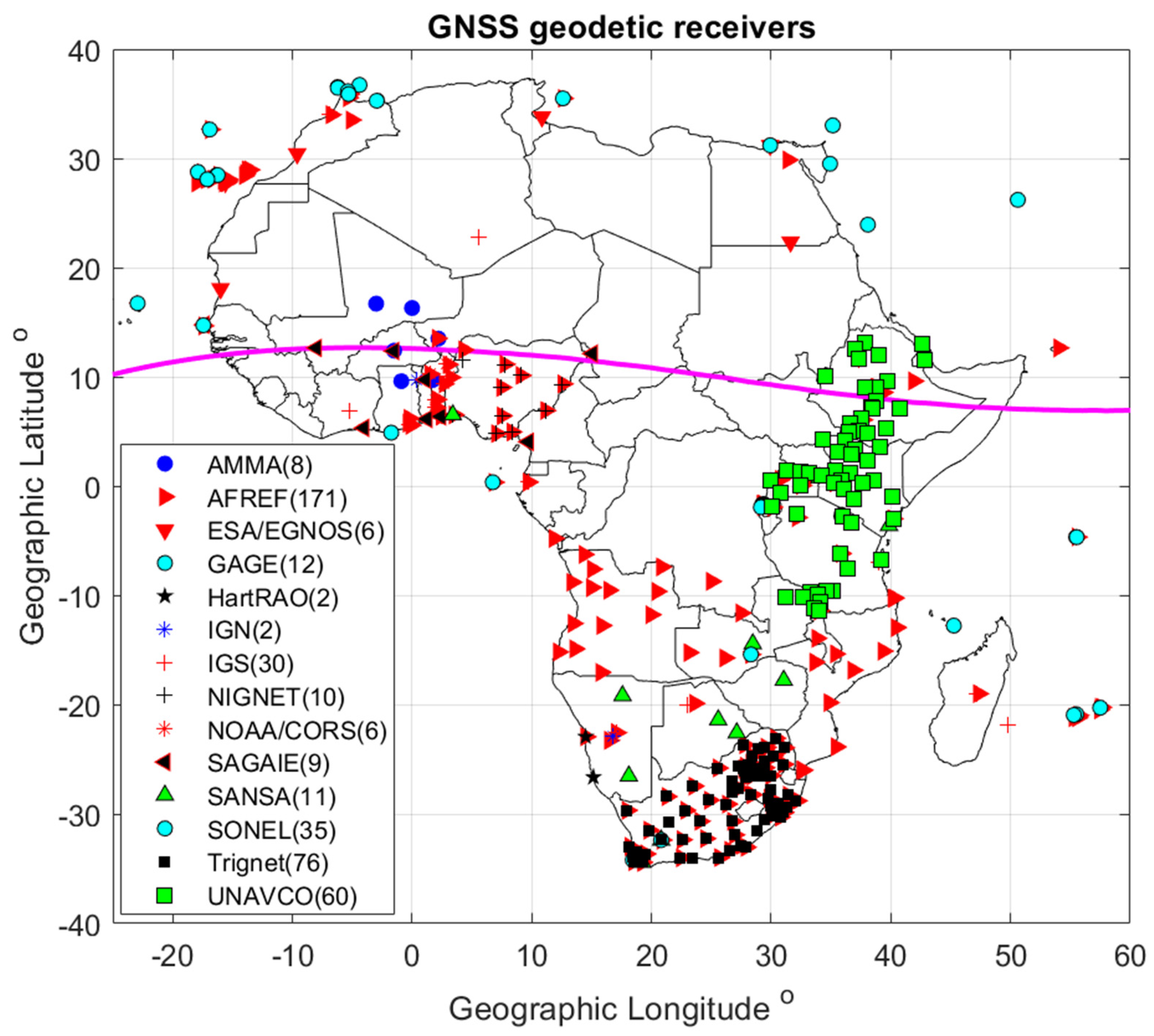
2.1.1. Global Navigation Satellite Systems Receivers
- (a)
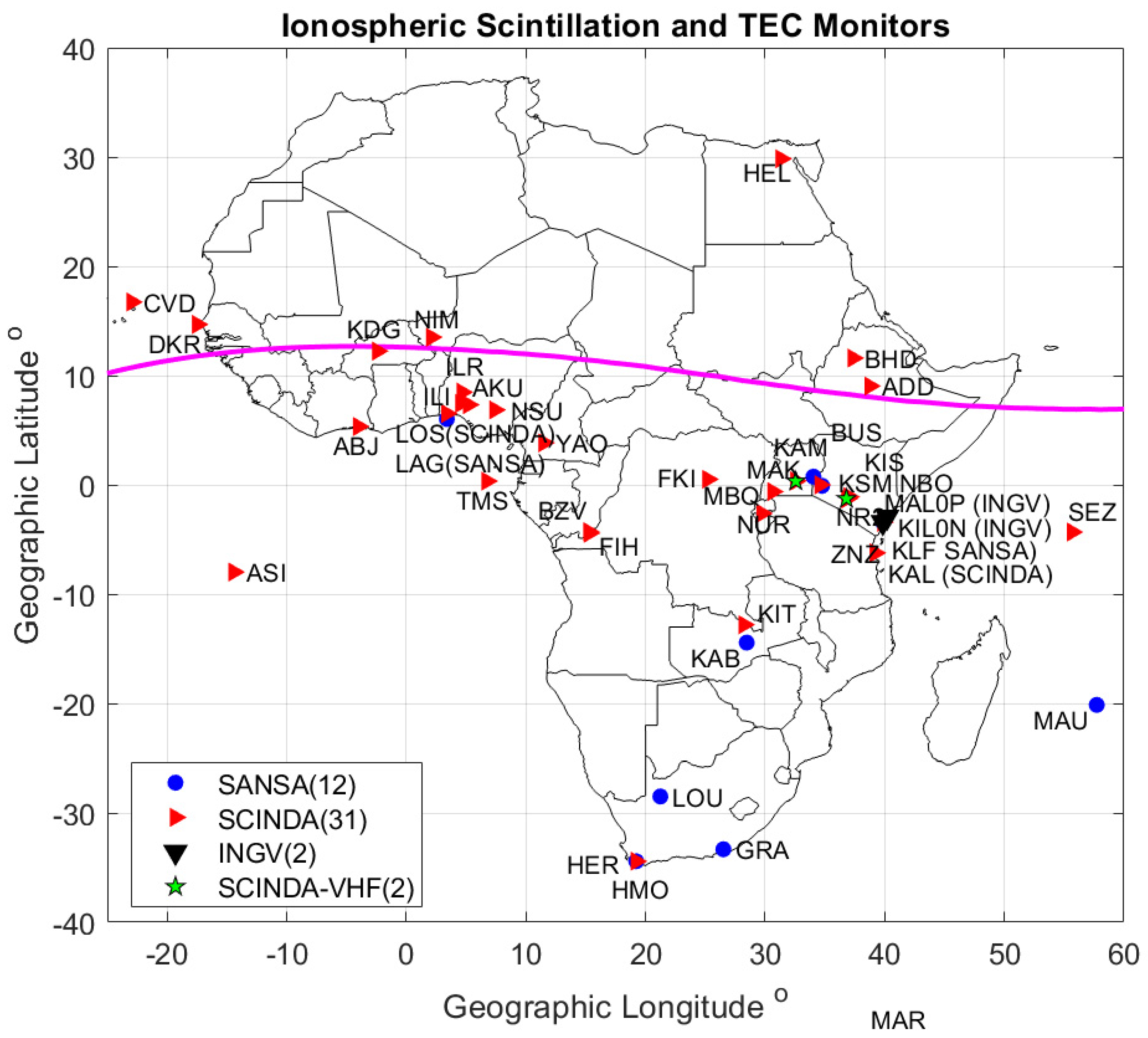
- GNSS Receivers for Ionospheric Scintillation Monitoring
- (b)
- Geodetic GNSS Receivers and GNSS reference receivers for surveying and mapping.
- (c)
- GAGE/UNAVCO Network
- (d)
- The African Geodetic Reference Frame (AFREF)
- (e)
- The TRIGNET Network
- (f)
- African Monsoon Multidisciplinary Analysis (AMMA) GPS Network [24]
- (g)
- The CNES/SAGAIE network
- (h)
- The SONEL network
- (i)
- CORS and Private Networks
- (j)
- OMNISTAR Differential GNSS
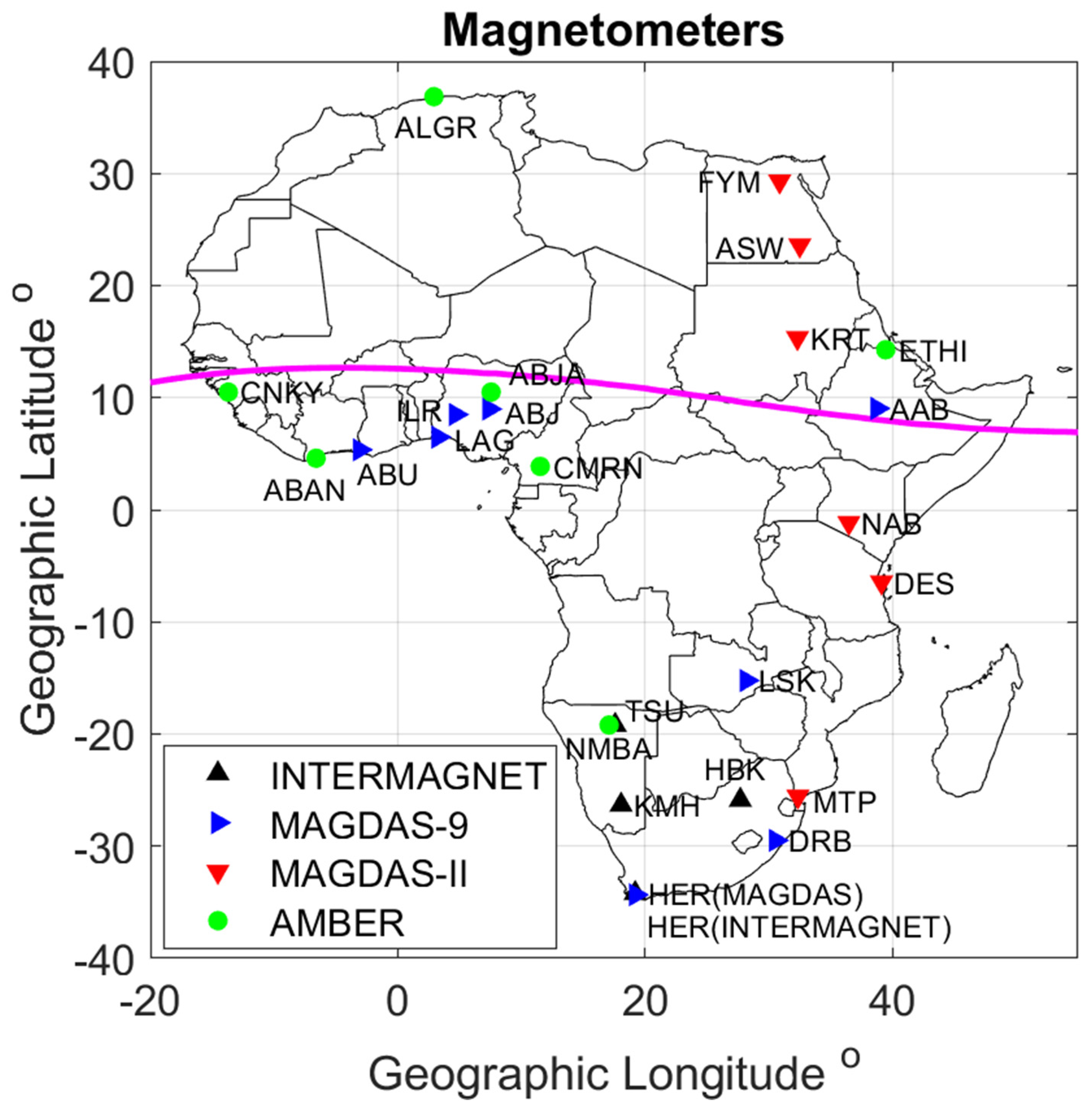
2.1.2. Magnetometers in Africa
- (a)
- (b)
- (c)
- INTERMAGNET
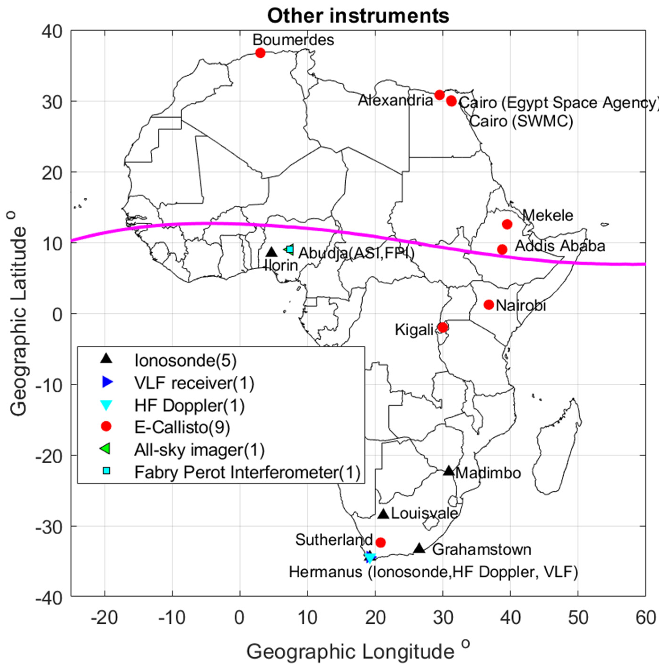
2.1.3. Other Ground-Based Facilities
- (a)
- Incoherent Scatter Radars
- (b)
- Ionosondes
- (c)
- Very-Low-Frequency (VLF) and Very-High-Frequency (VHF) receivers
2.2. Data Access and Reliability
2.3. Space Weather Products and Services
3. Human Capital Development
3.1. Capacity Building
3.2. International Achievements [47,48]
3.3. Initiatives by Professional Societies/International Organizations
- (a)
- African Geophysical Society
- (b)
- URSI Commission G Working group: “Capacity building and training”
- (c)
- Scientific Committee on Solar-Terrestrial Physics (SCOSTEP)
- (d)
- The Abdus Salam International Centre for Theoretical Physics/Boston College/INGV
- (e)
3.4. International Collaborations
- (a)
- Training of trainers and their students: The first cohort of African lecturers who were converted from their fields of research to space weather research were made hosts of space weather equipment. The equipment hosts were then trained to archive and use the data produced for research. The pioneering students who used the data for their postgraduate research were jointly supervised by their home-based academic staff and equipment donors. This model has enabled Africans to do research at their home institutions where they were/are registered as students while also building international networks and collaborations. The model forestalled potential brain drain.
- (b)
- Intra-Africa co-supervision of postgraduate research: Many African students are given research topics by their African senior researchers who co-supervise them and also host them for research visits whenever possible.
3.5. Funding Sources
- (a)
- External financing: Most of the space weather capacity building has been supported through external funding, especially for the acquisition and installation of research equipment, but local African universities have often provided their students with the necessary facilitation to enable them to undertake their research work. More often than not, the facilitation has been in terms of tuition fee waivers and in-kind support.
- (b)
- Government: Some national space agencies and research councils/agencies are now funding space weather research and training workshops to build a critical mass of expertise within the shortest time possible.
- (c)
- Industry: A few industry stakeholders, like the aviation industry and electric power distribution companies, in some few African countries have also come on board to support space weather research, although their involvement is still at a very low level. The challenge here has been that the industry players are not aware of the relevance of space weather research to their businesses. This calls for more awareness campaigns to enlighten the industry, and thus possibly attract more funding from the sector.
4. Gaps in Infrastructure and Human Resources
Gaps
5. Conclusions and the Way Forward
- (a)
- There is a huge infrastructure gap, so more instruments need to be deployed for space weather monitoring in Africa to fill in the gaps. This should not be left entirely to outsiders. There is a need for more African institutions/governments to invest in space weather research. To a small extent, this already happening, especially as an initiative by some space agencies in Africa, and perhaps the newly established African Space Agency should play a more proactive role in this.
- (b)
- The community of space weather researchers in Africa is growing in number and competence, and this should encourage collaborations with other researchers from outside the continent. African and other researchers should team up and run more joint research projects, write proposals for funding, and carry out joint supervision of students.
- (c)
- There is a need to develop thresholds of space weather threats on a variety of technological systems in Africa to inform space weather services in Africa.
- (d)
- There is a need to create more awareness among the potential commercial stakeholders whose infrastructures and businesses could be impacted by space weather so that they put in place measures to mitigate space weather impacts. This could be one avenue for attracting the funding needed for research and development.
- (e)
- We recommend that the African Space Agency (AfSA), when it becomes operational, takes up the challenge of improving space weather research infrastructure in the continent.
- (f)
- Finally, it is well known that space weather prediction can only be possible by fully understanding the complex interactions and coupling occurring between the upper and the lower atmosphere, including the troposphere level. In this regard, the African continent offers a unique opportunity to have a global view as it is mostly composed of land areas spanning the northern mid-latitudes to the southern mid-latitudes. For this reason, the installation of different pieces of space-weather-monitoring equipment in Africa will have important and priceless benefits for the space weather field as a whole.
Author Contributions
Funding
Institutional Review Board Statement
Informed Consent Statement
Data Availability Statement
Conflicts of Interest
References
- Knipp, D.D. Understanding Space Weather and the Physics Behind It; The McGraw-Hill Companies Inc.: New York, NY, USA, 2011; ISBN 13-978-0-07-340890-3. [Google Scholar]
- Available online: https://cddis.nasa.gov/Data_and_Derived_Products/GNSS/GNSS_data_and_product_archive.html (accessed on 26 November 2023).
- Gaunt, C.T.; Coetzee, G. Transformer failures in regions incorrectly considered to have low GIC-risk. In Proceedings of the IEEE Lausanne Power Tech Conference, Lausanne, Switzerland, 1–5 July 2007. [Google Scholar] [CrossRef]
- Institute for Scientific Research, Boston College, USA. Available online: https://www.bc.edu/content/bc-web/research/sites/institute-for-scientific-research/research/space-weather.html (accessed on 26 November 2023).
- Akala, A.O.; Amaeshi, L.I.N.; Somoye, E.O.; Idolor, R.O.; Okoro, E.; Doherty, P.H.; Groves, K.M.; Bridgewood, C.T.; Baki, P.; D’Ujanga, F.M.; et al. Climatology of GPS Scintillations Over Equatorial Africa during the minimum and Ascending Phases of Solar Cycle 24. Astrophys. Space Sci. 2019, 17, 357. [Google Scholar] [CrossRef]
- Omondi, G.E.; Baki, P.; Ndinya, B.O. Total electron content and scintillations over Maseno, Kenya, during high solar activity year. Acta Geophys. 2019, 67, 1661–1670. [Google Scholar] [CrossRef]
- Paznukhov, V.V.; Carrano, C.S.; Doherty, P.H.; Groves, K.M.; Caton, R.G.; Valladares, C.E.; Seemala, G.K.; Bridgwood, C.T.; Adeniyi, J.J.; Amaeshi, L.L.; et al. Equatorial plasma bubbles and L-band scintillations in Africa during solar minimum. Annales Geophys. 2012, 30, 675–682. [Google Scholar] [CrossRef]
- Olwendo, O.J.; Baki, P.; Mito, C.; Doherty, P. Elimination of Superimposed Multipath effects on Scintillation Index on Solar Quiet Ionosphere at Low latitude using a single SCINDA-GPS receiver. In Proceedings of the 23rd International Technical Meeting of the Satellite Division of The Institute of Navigation (ION GNSS 2010), Portland, OR, USA, 21–24 September 2010; pp. 386–392. [Google Scholar]
- Olwendo, O.J.; Baki, P.; Cilliers, P.J.; Mito, C. Using GPS-SCINDA Observations to study the correlation between Scintillation, Total Electron Content Enhancement and Depletions over the Kenyan Region. Adv. Space Res. 2012, 49, 1363–1372. [Google Scholar] [CrossRef]
- D’Ujanga, F.M.; Baki, P.; Olwendo, O.J.; Twinamasiko, B.F. Total Electron Content of the Ionosphere at two stations in East Africa during the 24–25 October 2011 Geomagnetic storm. Adv. Space Res. 2013, 51, 712–721. [Google Scholar] [CrossRef]
- Olwendo, J.; Baluku, T.; Baki, P.; Cilliers, P.J.; Mito, C.; Doherty, P. Low Latitude Ionospheric Scintillation and ionospheric Irregularity Drifts observations with SCINDA_GPS and VHF receivers in Kenya. Adv. Space Res. 2013, 51, 1715–1726. [Google Scholar] [CrossRef]
- Ngwira, C.M.; Lenzing, J.; Olwendo, J.; D’Ujanga, F.M.; Baki, P. A Study of Intense Ionospheric Scintillation Observed During a Quiet Day in the East African Low Latitude Region. Radio Sci. 2013, 48, 1–10. [Google Scholar] [CrossRef]
- Kahindo, B.M.; Kazadi Mukenga Bantu, A.; Fleury, R.; Zana, A.T.K.; Ndontoni, Z.; Kakule Kaniki, M.; Amory-Mazaudier, C.; Groves, K. Contribution à l’étude de la scintillation ionosphérique équatoriale surla crête sud de l’Afrique. J. Sci. 2017, 17, 27–47. [Google Scholar]
- Mahrous, A.; Ibrahim, M.; Makram, I.; Berdermann, J.; Salah, H.M. Ionospheric scintillations detected by SCINDA-Helwan station during St. Patrick’s Day geomagnetic storm. NRIAG J. Astron. Geophys. 2018, 7, 214–219. [Google Scholar] [CrossRef]
- Kotova, D.; Jin, Y.; Spogli, L.; Wood, A.G.; Urbar, J.; Rawlings, J.T.; Whittaker, I.C.; Alfonsi, L.; Clausen, L.B.; Høeg, P.; et al. Electron density fluctuations from Swarm as a proxy for ground-based scintillation data: A statistical perspective. Adv. Space Res. 2022, in press. [CrossRef]
- Kauristie, K.; Andries, J.; Beck, P.; Berdermann, J.; Berghmans, D.; Cesaroni, C.; De Donder, E.; de Patoul, J.; Dierckxsens, M.; Doornbos, E.; et al. Space Weather Services for Civil Aviation—Challenges and Solutions. Remote Sens. 2021, 13, 3685. [Google Scholar] [CrossRef]
- IGS. Available online: https://igs.org/network/ (accessed on 26 November 2023).
- SOPAC. Available online: http://sopac-old.ucsd.edu/sopacDescription.shtml (accessed on 26 November 2023).
- IGN in France. Available online: Ftp://igs.ign.fr//pub/igs/data/ (accessed on 26 November 2023).
- BKG in Germany. Available online: https://igs.bkg.bund.de/ (accessed on 26 November 2023).
- GAGE/UNAVCO. Available online: https://www.unavco.org/what-we-do/gage-facility/ (accessed on 26 November 2023).
- AFREF. Available online: http://afrefdata.org/ (accessed on 26 November 2023).
- TRIGNET. Available online: http://www.trignet.co.za/ (accessed on 26 November 2023).
- AMMA. Available online: https://grgs.obs-mip.fr/recherche/projets/amma/ (accessed on 26 November 2023).
- SAGAIE. Available online: Ftp://regina-public-sef.cnes.fr/Niveau0/SAGAIE/pub (accessed on 26 November 2023).
- SONEL. Available online: https://www.sonel.org/-GPS-.html?lang=en (accessed on 26 November 2023).
- OMNISTAR. Available online: https://www.omnistar.com/about-us/ (accessed on 26 November 2023).
- Magnetometers Data Center. Available online: http://magnetometers.bc.edu/index.php/amber2 (accessed on 26 November 2023).
- Anad, F.; Amory-Mazaudier, C.; Hamoudi, M.; Bourouis, S.; Abtout, A.; Yizengaw, E. Sq solar variation at Médéa Observatory (Algeria), from 2008 to 2011. Adv. Space Res. 2016, 58, 1682–1695. [Google Scholar] [CrossRef]
- Honore, M.E.; Anad, F.; Ngabireng, M.C.; Mbane, B.C. Sq (H) Solar Variation at Yaoundé-Came-roon AMBER Station from 2011 to 2014. Int. J. Geosci. 2017, 8, 545–562. [Google Scholar] [CrossRef]
- Honore, M.E.; Kosh, D.; Mbané, B.C. Day-to-Day Variability of H Component of Geomagnetic Field in Central African Sector Provided by Yaoundé-Cameroon Amber Station. Int. J. Geosci. 2014, 5, 1190–1205. [Google Scholar] [CrossRef]
- Available online: http://magdas2.serc.kyushu-u.ac.jp/station/index.html (accessed on 26 November 2023).
- Takla, E.M.; Yumoto, K.; Cardinal, M.G.; Abe, S.; Fujimoto, A.; Ikeda, A.; Tokunaga, T.; Yamazaki, Y.; Uo-zumi, T.; Mahrous, A.; et al. A study of latitudinal dependence of Pc 3-4 amplitudes at 96º magnetic meridian stations in Africa. Sun Geosph. 2011, 6, 67–72. [Google Scholar]
- Omondi, G.E.; Baki, P.; Ndinya, B.O. Quiet time correlation between the Geomagnetic Field variations and the Dynamics of the East African equatorial ionosphere. Int. J. Astrophys. Space Sci. 2017, 5, 6–18. [Google Scholar]
- Hawary, R.E.; Yumoto, K.K.; Mahrous, A.; Ghamry, E.; Meloni, A.; Badi, K.; Kianji, G.; Uiso, S.C.B.; Mwiinga, N.; Jao, L.L.; et al. Annual and semi-annual Sq variations at 96° MM MAGDAS I and II stations in Africa. Earth Planets Space 2012, 66, 425–432. [Google Scholar] [CrossRef][Green Version]
- Shimeis, A.; Fathy, I.; Amory-Mazaudier, C.; Fleury, R.; Mahrous, A.M.; Yumoto, K.; Groves, K. Signature of the Coronal Hole on near the North Crest Equatorial Anomaly over Egypt during the strong Geomagnetic Storm 5th April 2010. J. Geophys. Res. Space Phys. 2012, 117, A07309. [Google Scholar] [CrossRef]
- Honore, M.E.; Amaechi, P.O.; Daika, A.; Aziz, D.K.A.; Kaab, M.; Mbane, C.B.; Benkhaldoun, Z. Longitudinal Variability of the Vertical Drift Velocity Inferred from Ground-Based Magnetometers and C/NOFS Observations in Africa. Int. J. Geosci. 2022, 3, 657–680. [Google Scholar] [CrossRef]
- Omondi, S.; Akimasa, Y.; Waheed, K.Z.; Fathy, I.; Ayman, M. Alex magnetometer and telluric station in Egypt: First results on pulsation analysis. Adv. Space Res. 2022, 72, 711–725. [Google Scholar] [CrossRef]
- Intermagnet. Available online: https://www.intermagnet.org/imos/imotblobs-eng.php (accessed on 26 November 2023).
- Zaourar, N.; Amory-Mazaudier, C.; Fleury, R. Hemispheric asymmetries in the ionosphere response observed during the high-speed solar wind streams of the 24–28 August 2010. Adv. Space Res. 2017, 59, 2229–2247. [Google Scholar] [CrossRef]
- Kotzé, P.B.; Cilliers, P.J.; Sutcliffe, P.R. The role of SANSA’s geomagnetic observation network in space weather monitoring: A review. Space Weather 2015, 13, 656–664. [Google Scholar] [CrossRef]
- Nahayo, E.; Kotzé, P.B.; Cilliers, P.J.; Lotz, S. Observations from SANSA’s geomagnetic network during the Saint Patrick’s Day storm of 17–18 March 2015. S. Afr. J. Sci. 2019, 115, 5204. [Google Scholar] [CrossRef]
- CALLISTO Data. Available online: http://e-callisto.org/ (accessed on 26 November 2023).
- Minta, F.N.; Nozawa, S.I.; Kozarev, K.; Elsaid, A.; Mahrous, A.A. Solar radio bursts observations by Egypt-Alexandria CALLISTO spectrometer: First results. Adv. Space Res. 2022, 72, 844–853. [Google Scholar] [CrossRef]
- SANDMIS Data. Available online: https://sandims.sansa.org.za/ (accessed on 26 November 2023).
- INGV Data. Available online: http://www.eswua.ingv.it/ (accessed on 26 November 2023).
- AGU Basu Awards. Available online: https://honors.agu.org/sfg/basu-early-career-award-in-sun-earth-systems-science/ (accessed on 26 November 2023).
- AGU Africa Awards. Available online: https://www.agu.org/Honor-and-Recognize/Honors/Union-Awards/Africa-Award-Space-Science (accessed on 26 November 2023).
- Available online: www.girgea.org (accessed on 26 November 2023).
- Amory-Mazaudier, C.; Fleury, R.; Petitdidier, M.; Soula, S.; Masson, F.; Menvielle, M.; Damé, L.; Berthelier, J.-J.; Georgis, L.; Philippon, N.; et al. Recent Advances in Atmospheric, Solar-Terrestrial Physics and Space Weather, from a North-South network of scientists Results and Capacity Building. Sun Geosph. 2017, 12, 21–69. [Google Scholar]
- Loutfi, A.; Pitout, A.F.; Bounhir, Z.; Benkhaldoun, Z.; Makela, J.J. Interhemispheric asymmetry of the equatorial ionization anomaly (EIA) on the African sector over 3 years (2014–2016): Effects of thermospheric meridional winds. J. Geophys. Res. Space Phys. 2021, 127, 29902. [Google Scholar] [CrossRef]
- Available online: https://cosparhq.cnes.fr/awards/vikram-sarabhai-medal/ (accessed on 26 November 2023).
- Amory-Mazaudier, C.; Radicella, S.; Doherty, P.; Gadimova, S.; Fleury, R.; Nava, B.; Anas, E.; Petitdidier, M.; Migoya-Orué, Y.; Alazo, K.; et al. Development of research capacities in space weather: A successful international cooperation. J. Space Weather Space Clim. 2021, 11, 28. [Google Scholar] [CrossRef]


| Locations | Host Nation | Station Code | Network | Latitude | Longitude |
|---|---|---|---|---|---|
| Abidjan | Ivory Coast | ABJ | SCINDA | 5.34 | 5.36 |
| Addis Abeba | Ethiopia | ADD | SCINDA | 9.33 | 38.75 |
| Ascension Island | Atlantic Ocean | ASI | SCINDA | −7.98 | −14.41 |
| Bahir-Dar | Ethiopia | BHD | SCINDA | 11.57 | 37.39 |
| Brazzaville | Congo | BZV | SCINDA | −4.28 | 15.25 |
| Busitema | Uganda | BUS | SANSA | 0.75 | 34.04 |
| Butare | Rwanda | NUR | SCINDA | −2.61 | 29.74 |
| Cape Verde | Atlantic Ocean | CVD | SCINDA | 16.73 | −22.94 |
| Dakar | Senegal | DKR | SCINDA | 14.68 | −17.46 |
| Helwan | Egypt | HEL | SCINDA | 29.87 | 31.32 |
| Hermanus | South Africa | HMO | SCINDA | −34.42 | 19.22 |
| Ilorin | Nigeria | ILR | SCINDA | 8.48 | 4.67 |
| Kabwe | Zambia | KAB | SANSA | −14.44 | 28.46 |
| Kampala | Uganda | KAM | SCINDA | 0.37 | 32.56 |
| Kampala | Uganda | KMP | SCINDA-VHF | 0.37 | 32.56 |
| Kilifi | Kenya | KIL0N | INGV | −3.62 | 39.84 |
| Kilifi | Kenya | KAL | SANSA | −3.62 | 39.84 |
| Kinshasa | Congo | FIH | SCINDA | −4.42 | 15.31 |
| Kisangani | Congo | FKI | SCINDA | 0.51 | 25.21 |
| Kitwe | Zambia | KIT | SCINDA | −12.80 | 28.24 |
| Koudougou | Burkina Faso | KDG | SCINDA | 12.24 | −2.40 |
| Lagos | Nigeria | LOS | SCINDA | 6.52 | 3.39 |
| Lagos | Nigeria | LAG | SANSA | 6.52 | 3.39 |
| Malindi | Kenya | MAL0P | INGV | −2.93 | 40.21 |
| Maseno | Kenya | KIS | SCINDA | 0 | 34.6 |
| Mbarara | Uganda | MBQ | SCINDA | −0.62 | 30.65 |
| Nairobi (J K U) | Kenya | NBO | SCINDA | −1.09 | 37.02 |
| Nairobi (U of Nairobi) | Kenya | NR2 | SCINDA | −1.27 | 36.81 |
| Nairobi (U of Nairobi) | Kenya | NAI | SCINDA-VHF | −1.27 | 36.81 |
| Niamey | Niger | NIM | SCINDA | 13.50 | 2.10 |
| Nsukka | Nigeria | NSU | SCINDA | 6.86 | 7.41 |
| Sao Tome and Principe | Atlantic Ocean | TMS | SCINDA | 0.34 | 6.74 |
| Seychelles | Indian Ocean | SEZ | SCINDA | −4.32 | 55.69 |
| Yaounde | Cameroon | YAO | SCINDA | 3.90 | 11.50 |
| Zanzibar | Tanzania | ZNZ | SCINDA | −6.23 | 39.21 |
| Marker | Country | Latitude | Longitude |
|---|---|---|---|
| ABPO | Madagascar | −19.018 | 47.229 |
| ACRG | Ghana | 5.641 | −0.207 |
| ADIS | Ethiopia | 9.035 | 38.766 |
| ASCG | Ascension Is. | −7.916 | −14.333 |
| CPVG | Cape Verde | −16.732 | −22.935 |
| DJIG | Djibouti | 11.526 | 42.847 |
| FUNC | Portugal | 32.648 | −16.908 |
| HARB | South Africa | −25.887 | 27.707 |
| HNUS | South Africa | −34.425 | 19.223 |
| JCTW | South Africa | −33.951 | 18.469 |
| LLAG | Canary Is. | 28.482 | −16.321 |
| LPAL | Canary Is. | 28.764 | −17.894 |
| MAL2 | Kenya | −2.996 | 40.194 |
| MAS1 | Canary Is. | 27.764 | −15.633 |
| MAYG | Mayotte | −12.782 | 45.258 |
| MBAR | Uganda | −0.601 | 30.738 |
| MELI | Spain | 35.281 | −2.952 |
| MFKG | South Africa | −25.805 | 25.540 |
| NKLG | Gabon | 0.354 | 9.672 |
| PRE3 | South Africa | −25.746 | 28.224 |
| RABT | Morocco | 33.998 | −6.854 |
| REUN | La Reunion | −21.208 | 55.572 |
| SEYG | Seychelles Is. | −4.679 | 55.531 |
| STHL | Sainte Helene | −15.943 | −5.667 |
| SUTH | South Africa | −32.380 | 20.810 |
| TDOU | South Africa | −23.080 | 30.384 |
| ULDI | South Africa | −28.293 | 31.421 |
| VACS | Mauritius | −20.297 | 57.497 |
| VOIM | Madagascar | −21.906 | 46.793 |
| WIND | Namibia | −22.575 | 17.089 |
| YKRO | Ivory Coast | 6.871 | −5.240 |
| ZAMB | Zambia | −15.426 | 28.311 |
| Marker | Country | Latitude | Longitude |
|---|---|---|---|
| ABI1 | Ivory Coast | 5.32 | −4.03 |
| CTO1 | Benin | 6.37 | 2.39 |
| DAK2 | Senegal | 14.76 | −17.38 |
| NIA1 | Togo | 9.74 | 1.12 |
| LOM2 | Togo | 6.14 | 1.24 |
| NDJA | Chad | 12.12 | 15.06 |
| OUAG | Burkina Faso | 12.36 | −1.53 |
| DOUA | Cameroon | 4.05 | 9.71 |
| BAM1 | Mali | 12.65 | −8.00 |
| Station and Host Country | Code | Geo Lat/ Geo Lon | Mag Lat/ Mag Lon | L-Shell Value |
|---|---|---|---|---|
| Medea Station Algeria | ALGR | 36.85 2.93 | 27.98 77.67 | 1.30 |
| Yaounde Station Cameroon | CMRN | 3.87 11.52 | −5.30 83.12 | 1.00 |
| Abidjan Station Côte d’Ivoire | ABAN | 4.60 −6.60 | −6.00 65.80 | 1.00 |
| Adigrat Station Ethiopia | ETHI | 14.28 39.46 | 5.90 111.06 | 1.00 |
| Conakry Station Guinea | CNKY | 10.50 −13.70 | −0.50 60.40 | 1.00 |
| Windhoek Station Namibia | NMBA | −19.20 17.09 | −33.15 84.65 | 1.40 |
| Abuja Station Nigeria | ABJA | 10.50 7.55 | 0.55 79.63 | 1.00 |
| Name | Organization | Email Address |
|---|---|---|
| Fatma Anad | Centre de Recherche en Astronomie Astrophysique et Géophysique (CRAAG), Algeria | f_anad@yahoo.fr |
| Cesar Biouele PhD. | University of Yaounde I, Cameroon | cesar.mbane@yahoo.fr |
| Amoré Nel, PhD | South African National Space Agency (SANSA), Hermanus, South Africa | anel@sansa.org.za |
| Alem Mebrahtu PhD. | Adigrat University, Ethiopia | alemmeb@yahoo.com |
| Rabiu Babatunde, PhD. | Centre for Atmospheric Science, National Space Research and Development, Nigeria | tunderabiu@yahoo.com |
| Abbrev. | Station Name | Nation | GG Lat. | GG Lon. | GM Lat. | GM Lon. | L-Shell | Dip Lat. | Installed | Type |
|---|---|---|---|---|---|---|---|---|---|---|
| FYM | Fayum | Egypt | 29.30 | 30.88 | 26.76 | 103.64 | 1.15 | 43.68 | 08/01/14 | MAGDAS-II |
| ASW | Aswan | Egypt | 23.59 | 32.51 | 20.88 | 108.75 | 1.07 | 33.98 | 08/12/23 | MAGDAS-II |
| KRT | Khartoum | Sudan | 15.33 | 32.32 | 12.76 | 107.18 | 1.01 | 16.30 | 08/09/23 | MAGDAS-II |
| AAB | Addis Ababa | Ethiopia | 9.04 | 38.77 | 5.56 | 112.51 | 1.00 | 3.39 | 06/08/19 | MAGDAS-9 |
| ILR | Ilorin | Nigeria | 8.50 | 4.68 | 10.42 | 78.83 | 1.00 | −8.44 | 06/08/24 | MAGDAS-9 |
| ABU | Abuja | Nigeria | 8.99 | 7.39 | 10.48 | 81.60 | 1.00 | −6.75 | 10/08/15 | MAGDAS-9 |
| LAG | Lagos | Nigeria | 6.48 | 3.27 | 8.65 | 77.11 | 1.00 | −13.91 | 08/09/04 | MAGDAS-9 |
| ABJ | Abidjan | Ivory Coast | 5.35 | −3.08 | 8.52 | 70.62 | 1.00 | −17.41 | 06/09/01 | MAGDAS−9 |
| NAB | Nairobi | Kenya | −1.16 | 36.48 | −4.18 | 108.73 | 1.09 | −22.36 | 08/09/16 | MAGDAS-II |
| DES | Dar Es Salaam | Tanzania | −6.47 | 39.12 | −9.83 | 110.54 | 1.09 | −33.10 | 08/09/10 | MAGDAS-II |
| LSK | Lusaka | Zambia | −15.23 | 28.20 | −16.78 | 98.25 | 1.24 | −52.48 | 08/09/25 | MAGDAS-9 |
| MPT | Maputo | Mozambique | −25.57 | 32.36 | −27.63 | 100.52 | 1.53 | −60.40 | 08/09/15 | MAGDAS-II |
| DRB | Durban | South Africa | −29.49 | 30.56 | −31.20 | 97.92 | 1.67 | −62.05 | 08/09/08 | MAGDAS-9 |
| HER | Hermanus | South Africa | −34.34 | 19.24 | −34.14 | 85.64 | 1.83 | −64.74 | 07/09/14 | MAGDAS-9 |
| Station Code | Station Name | Country | Institution |
|---|---|---|---|
| ABJ | Abidjan | Ivory Coast | University of Cocody |
| LAG | Lagos | Nigeria | Redeemer’s University |
| ILR | Ilorin | Nigeria | University of Ilorin |
| ABU | Abuja | Nigeria | National Space Research and Development Agency |
| AAB | Addis Ababa | Ethiopia | Addis Ababa University |
| HER | Hermanus | South Africa | SANSA Space Science |
| DRB | Durban | South Africa | University of KwaZulu Natal |
| MTP | Maputo | Mozambique | Eduardo Mondlane University |
| LSK | Lusaka | Zambia | University of Zambia |
| DES | Dar es Salaam | Tanzania | University of Dar es Salaam |
| NAB | Nairobi | Kenya | University of Nairobi |
| KRT | Khartoum | Sudan | University of Khartoum |
| ASW | Aswan | Egypt | Helwan University |
| FYM | Fayum | Egypt | Helwan University |
| Countries | AWESOME | VHF | SID |
|---|---|---|---|
| Algeria | 1 | 0 | 2 |
| Burkina Faso | 0 | 0 | 1 |
| Congo Brazzaville | 0 | 0 | 6 |
| Ivory Coast | 0 | 2 | 2 |
| Egypt | 1 | 2 | 14 |
| Ethiopia | 1 | 2 | 14 |
| Kenya | 0 | 2 | 3 |
| Libya | 2 | 0 | 1 |
| Morocco | 1 | 0 | 0 |
| Namibia | 0 | 0 | 1 |
| Nigeria | 0 | 2 | 38 |
| Senegal | 0 | 0 | 1 |
| South Africa | 0 | 2 | 13 |
| Tunisia | 1 | 0 | 9 |
| Uganda | 0 | 2 | 4 |
| Zambia | 0 | 0 | 2 |
| Country | School/Workshop | PhD | Universities/Institutions |
|---|---|---|---|
| Algeria | ISWI Maghreb Algerian (ISWI Maghreb) School organized in 2013 at Algiers University—6–16 May 2013 | PhDs defended: 4; in progress: 3 | USTHB, CTC Arzew, CRAAG |
| Benin | No school but the participation of students in l ISWI school, Maghreb, West Africa | PhDs defended: 1; in progress:1 | University of Abomey-Calavi |
| Burkina Faso | No schools/workshops but the participation of students in the ISWI School, Maghreb West Africa | PhDs defended: 16; in progress: 16 | University Nobert ZONGO University Joseph Ki-ZERBO University Nazi BONI (Bobo Dioulasso) IRSAT/National Center for Scientific Research and Technology |
| Cameroon | No school, but the participation of students in the ISWI, school, Maghreb, West Africa | PhD defended: 1 | Higher Technical Teacher Training College/Department of Geomatics, University of Ebolowa, Cameroon |
| Ivory Coast | International school in Abidjan (15–25 October 1995), Ivory Coast 3rd edition of the ISWI-Magreb-West Africa Space Weather School (IMAO), UFHB, Bingerville (16–28 October 2017), Ivory Coast | PhDs defended: 15; in progress: 4 | University Félix Houphouët Boigny, Cocody, Abidjan University of Man University Pelefero gon Coulibaly, Korhogo |
| Democratic Republic of Congo | School ISWI in Kinshasa, 11–24 September 2011 | PhDs defended: 5; in progress: 1 | University of Kinshasa |
| Egypt | International Space Weather Initiative (ISWI) UN/NASA/JAXA Workshop 6–10 November 2010 Helwan, Egypt International Workshop on Space Weather and Space Navigation, 3–4 October 2017, Beni-Suef University, Egypt African Geophysical Society Conference on Space Weather, 25–28 March 2019, Cairo, Egypt | PhDs defended: 5; in progress: 3 | Space Environment Research Lab at Egypt, Japan University of Science Technology (E-JUST) Space Weather Monitoring Center at Helwan University Faculty of Navigation Science and Space Technology-Beni Suef University Department of Astronomy and Meteorology, Faculty of Sciences, Cairo University National Research Institute of Astronomy and Geophysics (NRIAG) National Authority for Remote Sensing & Space Sciences Egyptian Space Agency |
| Ethiopia | IHY—Africa Space Weather Science and Education workshop, 12–16 November 2007, Addis Ababa, Ethiopia AGU-Chapman conference, Addis Ababa, 12–16 November 2012 First ISWI Space Science School in Bahir Dar University, November 2010 in Ethiopia. 14th International Symposium on Equatorial Aeronomy, 19–23 October 2015, Bahir Dar, Ethiopia | PhD defended: 10 in progress: 6 | Physics Department Science College, Bahir Dar University, Washera Geospace and Radar Science Research Laboratory at Bahir Dar University Department of Physics, Addis Ababa University Institute of Geophysics, Space Science and Astronomy (IGSSA), Addis Ababa University, Entoto Observatory and Research Center, Ethiopia |
| Guinea | No school, but participation of students in the ISWI Maghreb West Africa school | PhD defended: 1 | |
| Kenya | African Geophysical Society Conference on Space Weather, Nairobi, 21–25 September 2015 The Eastern Africa GNSS and Space Weather Capacity Building Workshop, 13–17 May 2019 The second edition of the Eastern Africa GNSS and Space Weather Capacity Building Workshop, 21–25 June 2021 East, Central, and Southern Africa GNSS and Space Weather Workshop, 9–23 July 2010, Nairobi, Kenya. ISWI/SCOSTEP Space Science School, October 21– 1 November 2013, Kenya Institute of Education, Nairobi, Kenya | PhDs defended: 3; in progress: 1 | Pwani University Technical University of Kenya Maseno University Jomo Kenyatta University of Science and Technology University of Nairobi Masinde Muliro University of Science and Technology |
| Morocco | Workshop on Space Weather and Instruments with the Illinois Space Weather team, the Moroccan team, and master’s and PhD students for the installation of the RENOIR (Remote Equatorial Night-time Observatory of Ionospheric Regions), 4–11 November 2013 ISWI school (Space Weather) organized in 2014 at Cady Ayyad University, 5–10 May 2014 | PhDs defended: 3; in progress: 3 | University Cady Ayyad at Marrakech |
| Morocco | ISWI School of Space Weather and GNSS, 16–21 February 2015 African Workshop on GNSS and Space Weather, 5–6 October 2020 ICTP activity co-organized by CRASTE-LF UNOOSA–ICG and Boston College scheduled in Rabat and held online because of COVID-19 | African Regional Centre for Space Science and Technology Education in French Language (CRASTE-LF) | |
| Nigeria | Third United Nations/European Space Agency Workshop on Basic Space Science, 18–22 October 1993, Lagos First Annual National Workshop of the International Heliophysical Year (IHY), Nigeria, 27 October 2005, Federal University of Technology, Akure, Nigeria African Regional International Heliophysical Year School (AFRIS), 9–22 November 2008, Enugu, Nigeria Nigerian National Meeting on GNSS Science and Application: National Augmentation System For GPS (application to geodesy, air, ground and water navigation systems), 16–19 November 2009, Virtual Library Hall, National Universities Commission (NUC), Abuja, Nigeria 2009 African Regional Conference of the International Academy of Astronautics; 24–26 November 2009, Abuja, Nigeria ISWI/MAGDAS School on Litho-Space Weather, 15–21 August 2011, Redeemer’s University, Mowe, Nigeria UN/Nigeria Workshop on International Space Weather Initiative ISWI, 17–21 October 2011, Abuja, Nigeria 2nd African Regional Centre for Space Science Technology Education—English (ARCSSTEE) regional conference, 22–24 August 2012, Obafemi Awolowo University, Ile-Ife, Nigeria National Conference on Space Weather and Space-Based Technologies, 2–9 February 2013, Bells University of Technology, Ota, Nigeria 2nd Cyril Onwumechili School on Physics of Upper Atmosphere, 23–27 June 2013, Centre for Atmospheric Research, Anyigba, Nigeria International Space Weather School, 20–25 January 2014, Bells University of Technology, Ota, Nigeria Centre for Satellite Technology Development (CSTD) Space Week 2014, 3–5 June 2014, Abuja, Nigeria. African Geophysical Society Conference 2–6 June 2014, Abuja, Nigeria 2nd Annual Nigerian Geophysical Society Conference, 17–20 March 2015, Covenant University, Canaanland, Ota, Nigeria International School on Equatorial and Low-Latitude Ionosphere (ISELLI), 14–18 September 2015 Centre for Atmospheric Research, National Space Research and Development Agency (NASRDA), Abuja, Nigeria Radicella 80th Birthday Symposium, University of Lagos, Akoka, Nigeria, UNILAG, 8th May 2017 Nigerian Geophysical Society 4th International Conference, Bayero University, Kano, Nigeria, 9–12 May 2017 5th Nigerian Geophysical Society Annual International Conference, Federal University, Dutse, Jigawa, Nigeria, 19th and 22nd June 2018. Superdarn radar workshop, Bowen University, Iwo, Nigeria, June 3–7 June 2019 International Colloquium on Equatorial and Low-Latitude Ionosphere (ICELLI, UNILAG), 9–13 September 2019 2nd International Colloquium on Equatorial and Low-Latitude Ionosphere (ICELLI), online, 15–17 September 2020 International Colloquium on Equatorial and Low-Latitude Ionosphere (ICELLI), Bowen University, Iwo, Nigeria, September 13–18, 2021, | PhDs defended: 20; in progress: 15 | More than 20 Nigerian Universities are offering graduate programs in space-weather-related fields Centre for Atmospheric Research, National Space Research and Development Agency, Anyigba, Nigeria African Regional Centre for Space Science and Technology Education in English Language (ARCSSTE-E) |
| Rwanda | School for describing and analyzing solar data for a better prediction of space weather: postponed in July-August 2022 | PhDs in progress: 2 | University of Rwanda—College of Science and Technology University of Rwanda—College of Education |
| Republic of Congo | School IHY in RC, 2–9 December 2009 | PhD defended: 1; in progress: 2 | University Marien Ngouabi |
| Senegal | ISWI, Maghreb, West Africa school organized in 2019 at Thiès University—15 to 25 October 2019 | PhDs defended: 2; in progress: 3 | University Iba Der Thiam of Thiès |
| South Africa | International Reference Ionosphere Workshop hosted by SANSA: 10–14 October 2011 African Workshop on Space Science Research held at SANSA, Hermanus, South Africa: 04–08 May 2015 South African National Space Agency (SANSA) and European Space Agency (ESA) The Path to South Africa—European Space Innovation Partnerships Workshop Program, Hermanus, 31 January 2019–2 February 2019 Joint IAPSO-IAMAS-IAGA Assembly, Cape Town, South Africa, 26 Aug–01 Sept, 2017 The 17th European Incoherent Scatter Scientific Association (EISCAT) Symposium and 42nd Annual European Meeting on Atmospheric Studies by Optical Methods (42AM), Hosted by SANSA during 14–18 September 2015 SANSA also participates in the International Space Weather Camp (ISWC), which brings together students from South Africa, the USA, and Germany to learn about space physics topics, including space weather. This is an annual event, with the three countries alternating in hosting. | At least 15 students supervised by SANSA staff (in various universities) have graduated with MSc and PhD degrees in the past 4–5 years | South African National Space Agency, Hermanus, South Africa |
| Tunisia | The First IHY International Workshop on Advancing VLF Science Through the Global AWESOME Network, 30 May–01 June 2009, Tunis | PhD defended: 1 | Faculty of Sciences of Tunis |
| Uganda | No international school or conference has been organized in Uganda. The plan to host ISWI in Uganda in 2020 failed due to the COVID-19 pandemic | PhDs defended: 2; in progress: 3 | Physics Department, Muni University, Arua City, Uganda Physics department, Mbarara University of Science and Technology, Mbararara City Physics Department, Busitema University |
| Zambia | No space-weather-related international school or conference has been organized in Zambia. Zambia is strengthening its collaboration with South Africa. A workshop to sensitize government officials in space science is planned for June 2022. This has been organized specifically because the government is developing a space policy and strategy, and a need has arisen to educate the decision makers on the key benefits of space science | 1 PhD in progress | Department of Physics of Natural Sciences, University of Zambia, Lusaka Department of Physical Sciences, School of Natural Sciences, Kwame Nkrumah University |
| Name | Country | Year of Award | Award |
|---|---|---|---|
| John Bosco Habarulema | Uganda | 2014 | Basu Early Career Award in Sun-Earth System Science. |
| John Bosco Habarulema | Uganda | 2016 | AGU Africa Award for Research Excellence in Space Science |
| Joseph Olwendo | Kenya | 2016 | Basu Early Career Award in Sun-Earth System Science. |
| Melessew Nigusie | Ethiopia | 2017 | AGU Africa Award for Research Excellence in Space Science |
| Frédéric Ouattara | Burkina Faso | 2018 | AGU Africa Award for Research Excellence in Space Science |
| Zama T. Katamzi-Joseph | South Africa | 2018 | Basu Early Career Award in Sun-Earth System Science. |
| Andrew Akala | Nigeria | 2019 | AGU Africa Award for Research Excellence in Space Science |
| Olawale S. Bolaji | Nigeria | 2020 | AGU Africa Award for Research Excellence in Space Science |
| Country | Projects | Contacts |
|---|---|---|
| Algeria | - March 2022: installation of the Algerian GNSS network across the national territory with 109 stations by the INCT (National Institute of Cartography and Teledetection) | Naima ZAOURAR USTHB naimaboulasba@gmail.com |
| Benin | - Organization of a conference on the importance of space weather in the development of countries | Adébiyi Joseph ADECHINAN Physics Department University of Abomey-Calavi adechinanjoseph@yahoo.fr |
| Burkina Faso | - Developing SIG and drones for expert surveyor training - Burkina Sat1 project of nanosatellite launching (for agriculture, land management, Earth atmosphere study, and so on) - Acquisition of scintillator (Septentrio) for ionospheric investigation - Planetarium for presenting educational shows about astronomy -Meteorological station - Understanding the effect of geomagnetic activity on ionospheric dynamics | Jean-Louis ZERBO University Nazi BONI (Bobo Dioulasso) JeanLouis.zerbo@gmail.com |
| Cameroon | - African Meridian B-field Education and Research (AMBER) magnetometer Array Project since 2008 - SCINDA-GPS installation in 2009 | Honoré MESSANGA Higher Technical Teacher Training College/Department of Geomatics, University of Ebolowa, Cameroon messanga.honore@gmail.com |
| Ivory Coast | - Organization of IMAO5 (ISWI Maghreb West Africa, School) 2022 in Abidjan, 17–28 October - Study of the influence of solar events on GNSS positioning | Franck GRODJI University Félix Houphouët Boigny, Cocody, Abidjan franckgrodji@yahoo.fr |
| Democratic Republic of Congo | - The current situation is not known but some university lecturers have been attending GNSS workshops organized by ICTP and Boston College and the MAGDAS group. The lectures facilitated the deployment of a SCINDA GPS scintillation and TEC monitor in 2011. | Bruno KAHINDO University of Kinshasa bkahindo@gmail.com |
| Egypt | - Space weather forecasting and warning using artificial Intelligence - Installation of new equipment: Fluxgate Magnetometer and Telluric System CALLISTO Solar Radio Spectrometer GNSS TEC/Scintillation Monitoring Unit | Ayman MAHROUS Space Environment Research Lab at Egypt-Japan University of science technology(E-JUST) ayman.mahrous@ejust.edu.eg |
| Ethiopia | - Developing the state-of-the-art ionospheric TEC model for improved accuracy of positioning (applicable finally for agriculture, land management, and so on) - Understanding the triggering mechanism of the East African equatorial ionospheric post-sunset irregularities - Understanding the effect of geomagnetic storm time-driven ionospheric currents on low-latitude power grids | Melessew NIGUSSIE Washera Geospace and Radar Science Research Laboratory at Bahir Dar University melessewnigussie@yahoo.com |
| Guinea | No new initiatives | Rene TATO LOUA Direction Nationale de la Météorologie de Guinée lrenetatometeo@gmail.com |
| Kenya | - The 2022 event was planned and carried out at the ICTP in Italy during the first two weeks of October. The subsequent events in the years 2023 and 2024 are planned to be conducted at ICTP, Italy, and in Malindi, Kenya, respectively. These two workshops are planned in the framework of the NORISK project with the collaboration of the Italian Space Agency and the Kenyan Space Agency (ASI). - NORISK will install an ionosonde, a GNSS scintillation receiver, and ICT infrastructure for space weather data and product management in Malindi, and it will develop a nowcasting and forecasting model for TEC in the Eastern Africa region. - The Kenya Space Agency in the year 2020 disbursed about USD 30,000 to two universities for the installation of space weather monitors, and the work is still in progress. - Study of solar flares and geo-effectiveness and potential impact on GNSS systems. | Claudio CESARONI Istituto Nazionale di Geofisica e Vulcanologia claudio.cesaroni@ingv.it Local contact Joseph OLWENDO Pwani University j.olwendo@pu.ac.ke Director General, KSA Paul BAKI Technical University of Kenya |
| Morocco | - Measurements of thermospheric winds with Fabry–Perrot interferometer - Ionospheric irregularities analysis with an all-sky camera (PICASSO) - Analysis of GPS data from five GPS stations installed in Morocco - Analysis of satellite data (SWARM) - Use of simulation resources | Aziza BOUNHIR University Mohammed V of Rabat (and University Cady Ayyad of Marrakech) a.bounhir@uca.ma |
| Nigeria | - Studies on equatorial electrojet - Measurements of thermospheric winds with Fabry–Perrot interferometer - Measurements of thermospheric winds with Fabry–Perrot interferometer - Equatorial plasma bubbles with an all-sky camera - Analysis of GPS data during various scenarios such as geomagnetic storms, stratospheric warming, solar flares, etc. - Use of ground and satellite data for ionospheric studies - Complexities of the ionosphere using non-linear methods - Ionospheric irregularities studies | Scientists in various universities and research institutions including national space agencies tunderabiu@yahoo.com |
| Rwanda | -Space weather study through an analysis of solar radio bursts. -Kinematics of CMEs trough solar type II radio bursts and subsequent geo effectiveness -Empirical modelling of storms-time ionospheric TEC and other parameters. | Jean UWAMAHORO University of Rwanda—College of Science and Technology mahorojpacis@gmail.com |
| Republic Congo | - April 2022, National Week of Science: space technologies for sustainable development in Africa. - Contribution of solar wind parameters to the variation of ionospheric activity in the African equatorial zone | Bienvenue DINGA University Marien Ngouabi bvs_dinga@yahoo.fr |
| Senegal | - November 2017, installation of a GNSS station at the GLOSS tide gauge in Dakar - Installation of CORS (Continuously Operating Reference Stations) network in 2022, which will cover the country. This CORS network will define the Senegalese Datum - Project to launch a nanosatellite in 2023 | Idrissa GAYE University Iba Der Thiam of Thiès idrissagaye3@hotmail.com |
| South Africa | - Space Weather Project in preparation for providing ICAO advisories for the aviation industry. We are currently developing products such as real-time TEC maps, scintillation products, and 3-dimensional electron density reconstruction maps. - Coupled with the one above, there has been a focus on the installation of GNSS receivers outside South Africa, such as in Kenya and Zambia. All of these are aimed at improving the accuracy of our space weather products. - The National Astrophysics and Space Science Program (http://www.nassp.uct.ac.za/) trains postgraduate students in Astrophysics and Space Science. Students who choose the Space Science stream conduct various projects in space physics, including space weather. This program has three nodes at the University of Cape Town, North West University, and the University of KwaZulu Natal | John Bosco HABARULEMA South African National Space Agency, Hermanus, South Africa jhabarulema@sansa.org.za |
| Tunisia | - 2006, installation of an AWESOME station at the Faculty of Sciences of Tunis - 2007, installation of the first SID station at the Faculty of Sciences of Tunis - Since 2009, several super-SID stations have been installed - Tunisia launched its first nanosatellite on Mars in 2021 | Hassen GHALILA Faculty of Sciences of Tunis, University Tunis El Manar Hassen.ghalila@gmail.com |
| Uganda | - Developing an institute for space weather research at Busitema University | Patrick MUNGUFENI Physics Department, Muni University, Arua City, Uganda pmungufeni@gmail.com |
| Zambia | - Installation of Space Weather instrumentation - GNSS, total electron content (TEC), and scintillation monitor at Kwame Nkrumah University in Kabwe, Zambia, in March 2020 - Two (2) space-based augmentation (SBAS) reference receivers in the Northwestern District of Chavurah at the border with Angola and another in Kabwe at Kwame Nkrumah University in March 2020 | Patrick SIBANDA Department of Physical Sciences, School of Natural Sciences, Kwame Nkrumah University sibandapatrick.ps@gmail.com |
Disclaimer/Publisher’s Note: The statements, opinions and data contained in all publications are solely those of the individual author(s) and contributor(s) and not of MDPI and/or the editor(s). MDPI and/or the editor(s) disclaim responsibility for any injury to people or property resulting from any ideas, methods, instructions or products referred to in the content. |
© 2023 by the authors. Licensee MDPI, Basel, Switzerland. This article is an open access article distributed under the terms and conditions of the Creative Commons Attribution (CC BY) license (https://creativecommons.org/licenses/by/4.0/).
Share and Cite
Baki, P.; Rabiu, B.; Amory-Mazaudier, C.; Fleury, R.; Cilliers, P.J.; Adechinan, J.; Emran, A.; Bounhir, A.; Cesaroni, C.; Dinga, J.B.; et al. The Status of Space Weather Infrastructure and Research in Africa. Atmosphere 2023, 14, 1791. https://doi.org/10.3390/atmos14121791
Baki P, Rabiu B, Amory-Mazaudier C, Fleury R, Cilliers PJ, Adechinan J, Emran A, Bounhir A, Cesaroni C, Dinga JB, et al. The Status of Space Weather Infrastructure and Research in Africa. Atmosphere. 2023; 14(12):1791. https://doi.org/10.3390/atmos14121791
Chicago/Turabian StyleBaki, Paul, Babatunde Rabiu, Christine Amory-Mazaudier, Rolland Fleury, Pierre J. Cilliers, Joseph Adechinan, Anas Emran, Aziza Bounhir, Claudio Cesaroni, J. Bienvenue Dinga, and et al. 2023. "The Status of Space Weather Infrastructure and Research in Africa" Atmosphere 14, no. 12: 1791. https://doi.org/10.3390/atmos14121791
APA StyleBaki, P., Rabiu, B., Amory-Mazaudier, C., Fleury, R., Cilliers, P. J., Adechinan, J., Emran, A., Bounhir, A., Cesaroni, C., Dinga, J. B., Doherty, P., Gaye, I., Ghalila, H., Grodji, F., Habarulema, J.-B., Kahindo, B., Mahrous, A., Messanga, H., Mungufeni, P., ... Zerbo, J.-L. (2023). The Status of Space Weather Infrastructure and Research in Africa. Atmosphere, 14(12), 1791. https://doi.org/10.3390/atmos14121791