Evaluation of Rain Estimates from Several Ground-Based Radar Networks and Satellite Products for Two Cases Observed over France in 2022
Abstract
1. Introduction
2. Materials and Methods
2.1. Description of the Precipitation Products
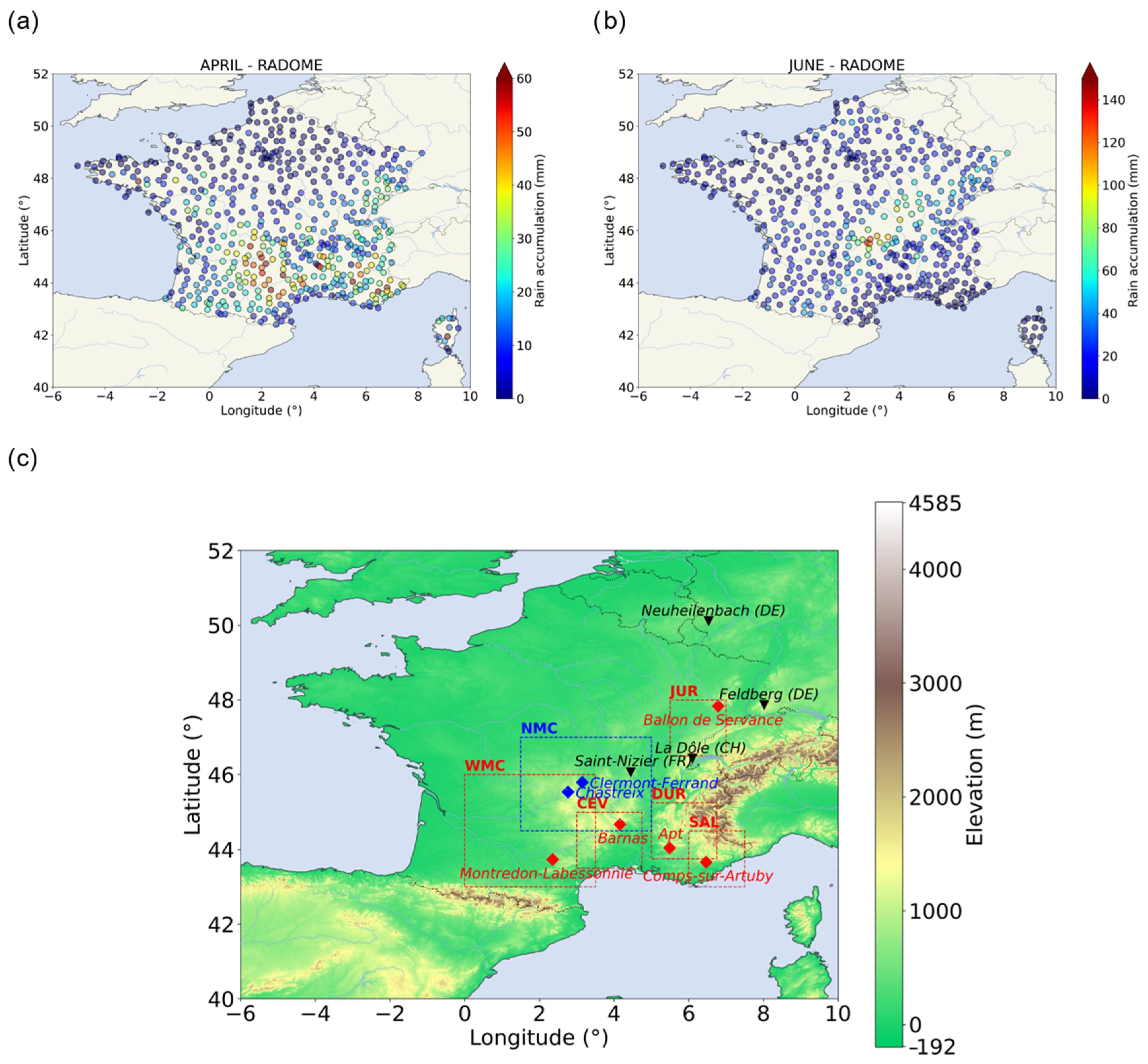
2.1.1. RADOME Rain Gauges Network
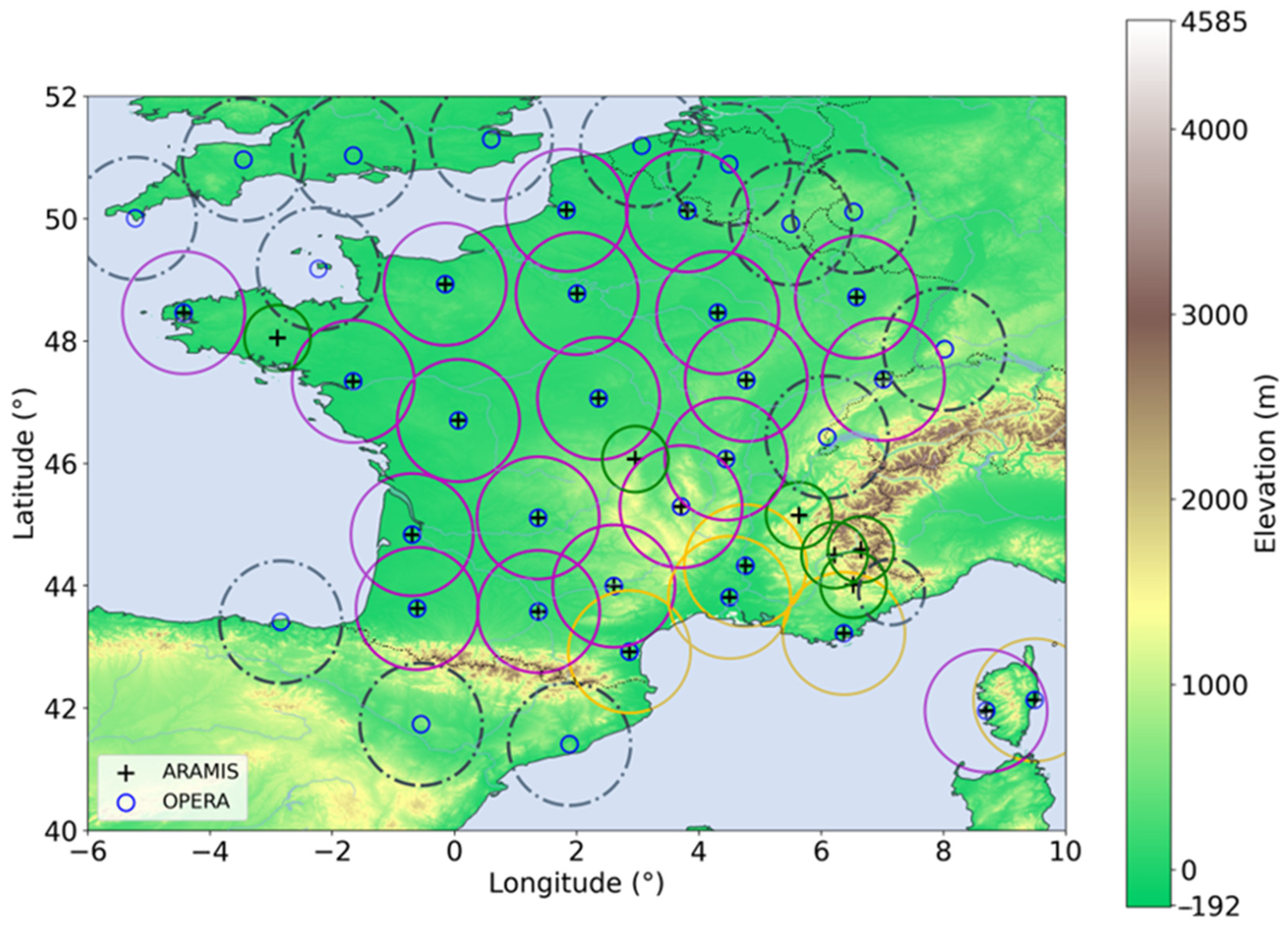
2.1.2. Radar Networks
- A ground-clutter identification by using pulse-to-pulse fluctuation of the radar reflectivity with further analysis for pixels adjacent to an identified clutter pixel;
- Non-meteorological echoes and precipitation-attenuation corrections from polarimetric modules;
- A partial beam-blockage correction by numerically simulating the interaction between the radar wave propagation and the ground by using orographic maps and long-term precipitation accumulation to identify trees and anthropogenic structures;
- A vertical profile of reflectivity correction deriving from ratios of hourly rainfall accumulation at different elevation angles and using these ratios to determine an optimal vertical profile reflectivity scheme from a predefined set;
- A gas-attenuation correction depending on the wavelength used and the altitude above the sea level;
- The synchronization or correction for advection;
- A weighted linear combination of the corrected reflectivity measurement at different elevation;
- The reflectivity (Z) conversion to rain rate (R) by using the Z-R relationship Z = 200 · R1.6, the 5 min rainfall accumulation;
- The rain-gauge adjustment.
- An anomaly-removal module identifying non-weather-related pixels;
- A hit-accumulation clutter filter which detects pixels with an occurrence frequency higher than a reference threshold of 0.6;
- A beam-blockage correction;
- A satellite-based filter of residual non-rain echoes from the probability of the Precipitation Clouds product of the EUMETSAT Nowcasting Satellite Application Facilities.
- The differences between the radars in the network;
- The contamination by non-meteorological targets (partially corrected as explained earlier and in [28] with the implementation of a hit-accumulation clutter);
- The absence of correction of the vertical profile of reflectivity of the raw scans;
- The use of the single Marshall-Palmer relationship to convert Z to R.
2.1.3. Satellite Precipitation Products
IR Sensor-Based Satellite Products
- A better identification of warmer stratiform clouds from higher temperature thresholds;
- An improvement in the watershed method used for the image segmentation;
- An improvement in the rainfall regime identification by adding monthly sets of cloud types to the existing cloud classification system;
- The use of PMW satellite data to adjust Tb–R curves;
Microwave Sensor-Based and Blended Products
- IMERG-Early (later called EARLY) is the earliest version of the IMERG product available after nominal observation; with approximately 4 h of data latency, the propagation of precipitation fields determined by the observation of IR sensors is applied only forward in time;
- IMERG-Late version (later called LATE) is available after a latency of 14 h and has its precipitation fields propagated forward and backward in time.
Carrier-to-Noise-Based Precipitation Product
2.2. Point-to-Pixel Comparative Method
- Geostatistical methods (e.g., the different Kriging methods; [58]).
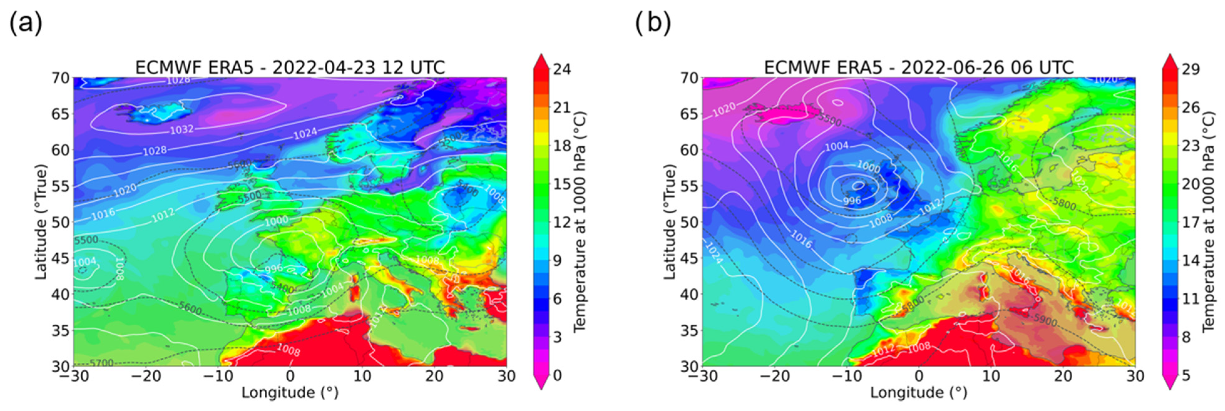
2.3. Synoptic Description of the Two Case Studies
3. Comparative Analyses Results
3.1. Rain-Gauge vs. Radar Observations
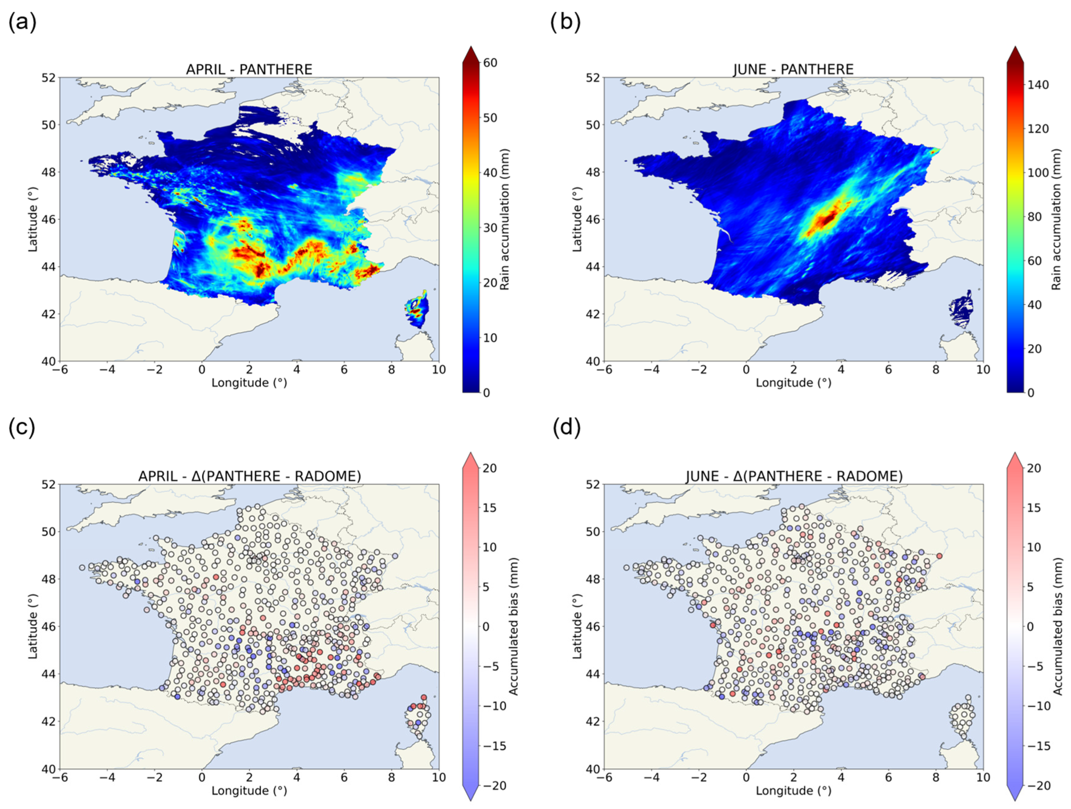
3.1.1. PANTHERE vs. RADOME
3.1.2. OPERA vs. RADOME
3.1.3. PANTHERE and OPERA vs. RADOME
3.2. Rain-Gauge vs. Satellite Precipitation Products
3.2.1. IR Sensor-Based Product
3.2.2. MW Sensor-Based Product
IMERG Products
CMORPH Products
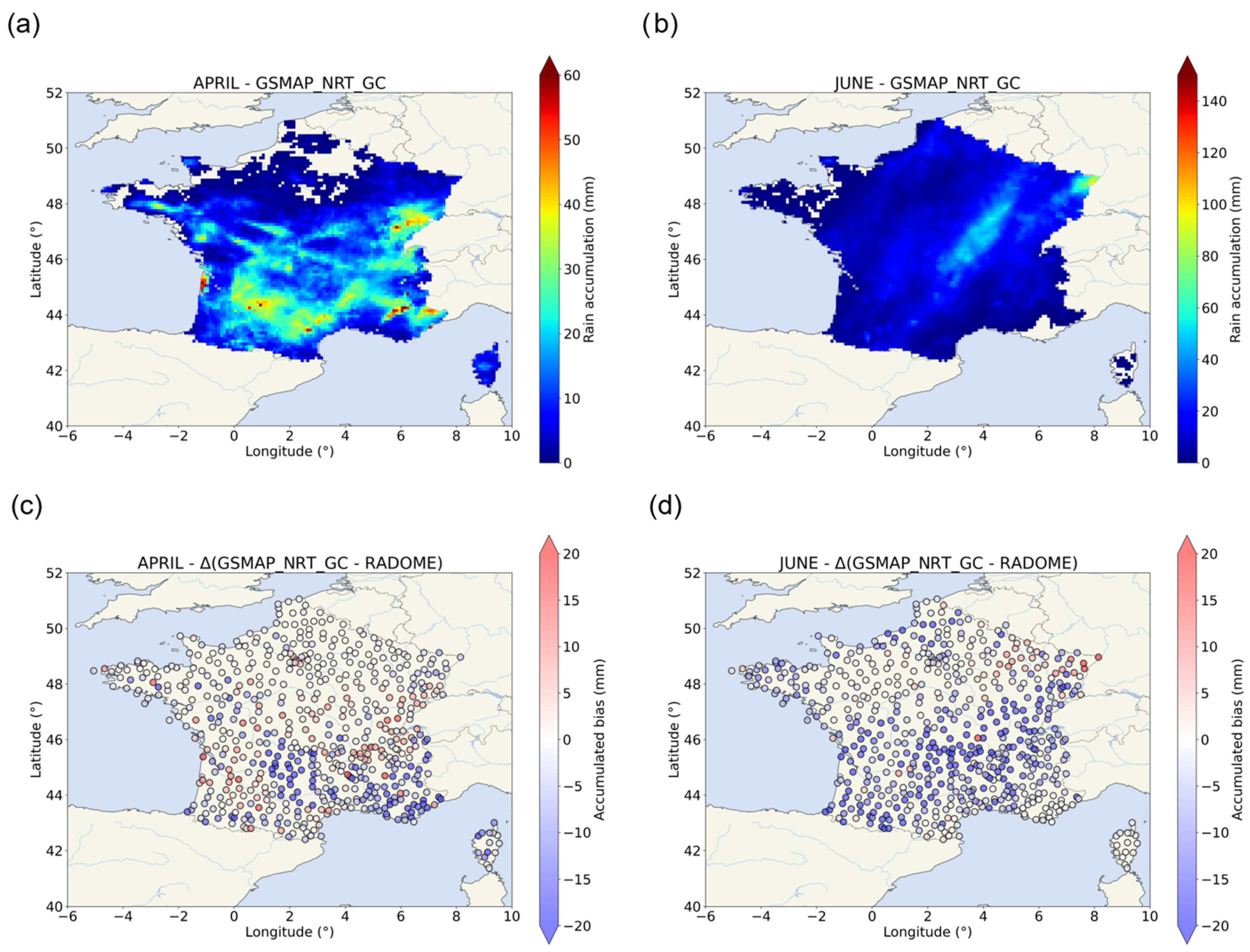
GSMaP Products
3.2.3. C/N-Based Product
4. Discussion
5. Conclusions and Perspectives
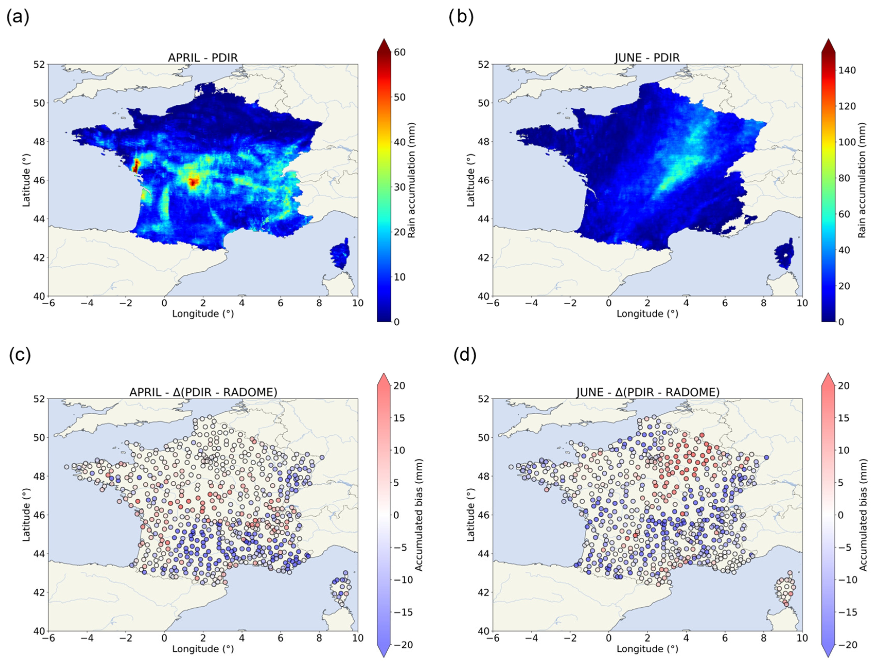
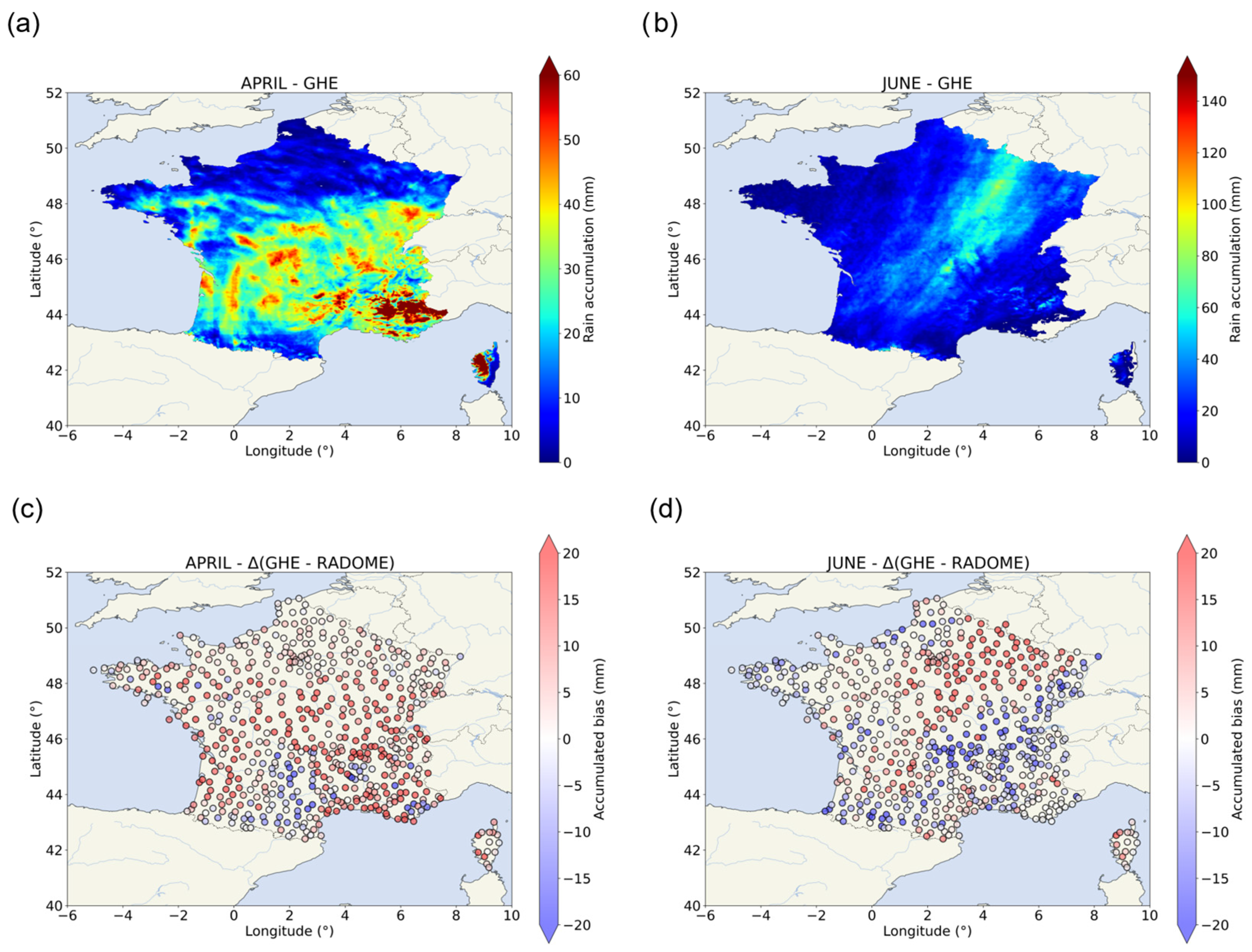
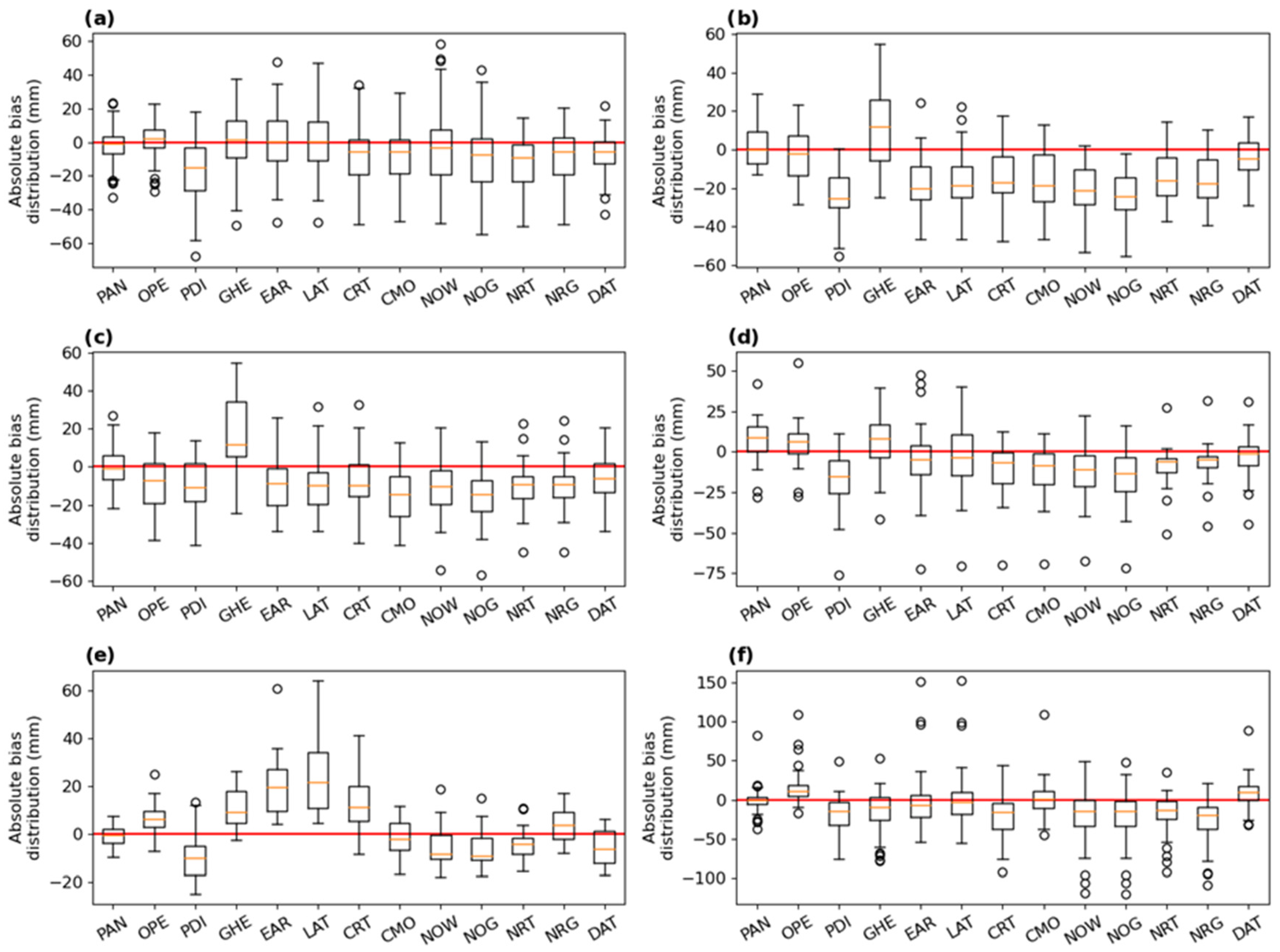
- PDIR and GHE found difficulty in identifying the position of the April event but correctly detected the June event. The IR-based technique might be well adapted for these more convective conditions with high spatial (4 × 4 km2) and temporal (15 min to 1 h) resolutions with relatively short latency (minutes to hours);
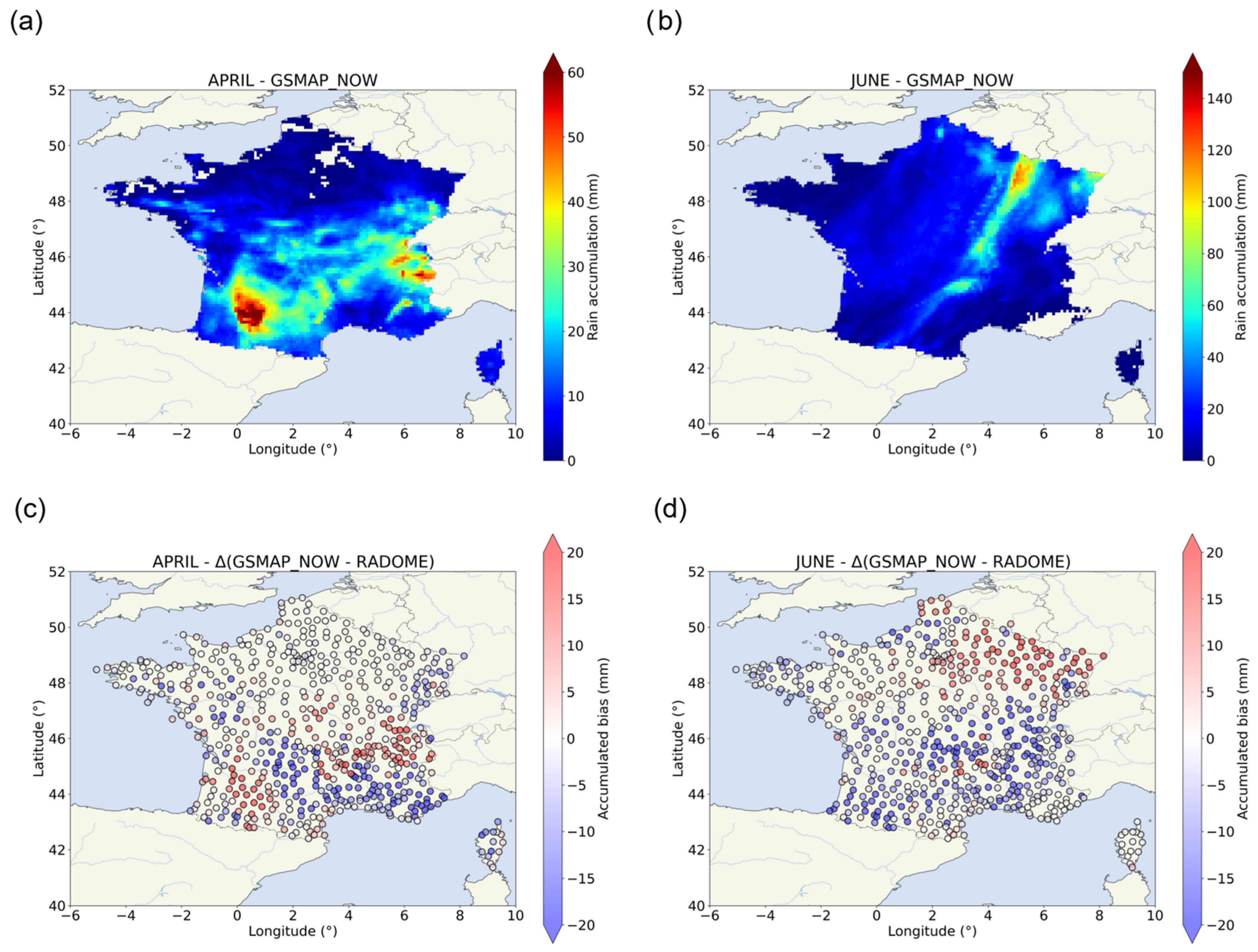
- Short-latency (real-time) MW-based products tend to produce worse representations of the precipitation cases such as CMORPH-RT and GSMaP-Now products. GSMaP-Now products had difficulty in representing the event but the quantification was coherent with the RADOME observations;
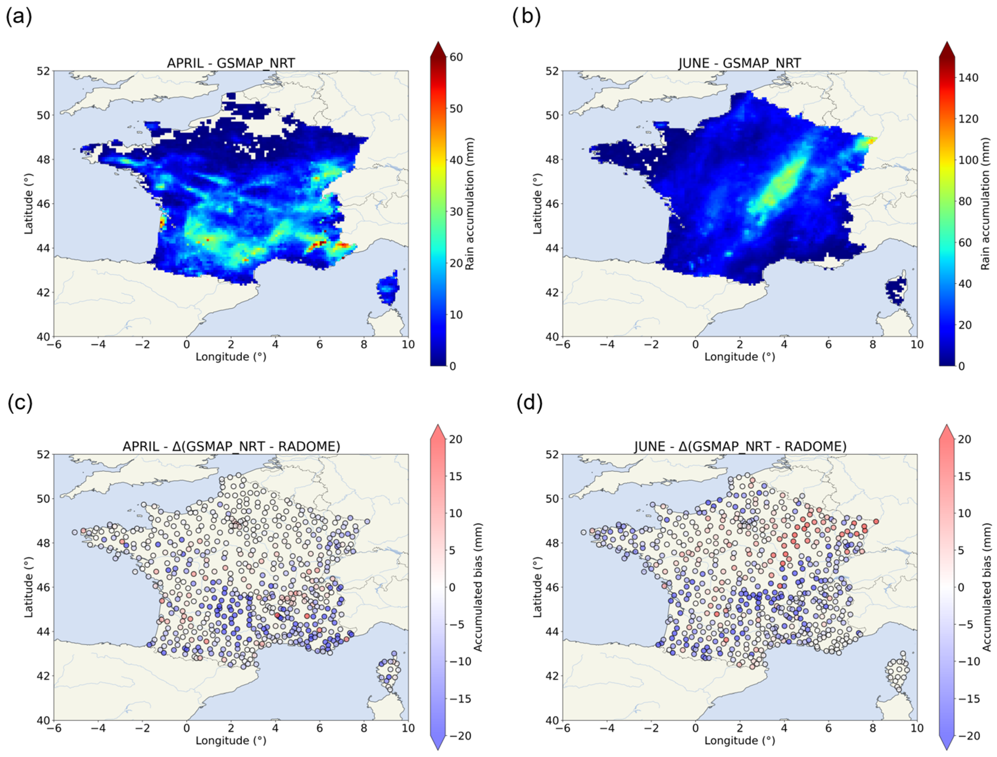
- In comparison, GSMaP-NRT performed better than GSMaP-Now in the detection of the event, especially in the identification of the June event;
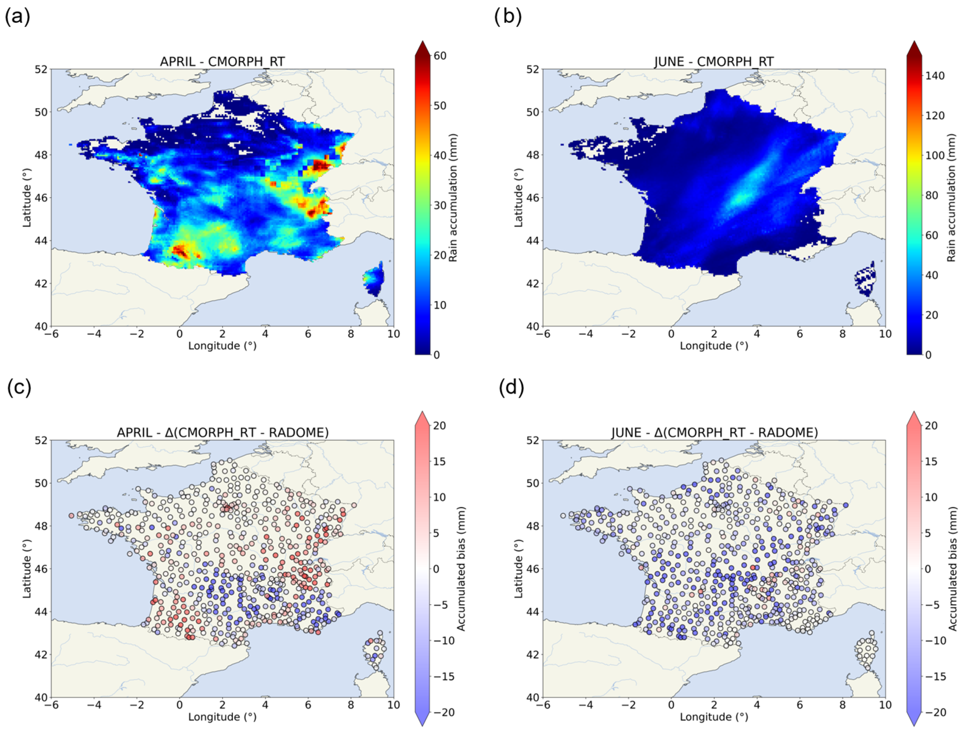
- A similar statement can be made about the reprocessed CMORPH version compared to the heterogeneity in precipitation amounts’ quantification by CMORPH-RT. The morphing method allowed for a better representation and quantification of both case studies;
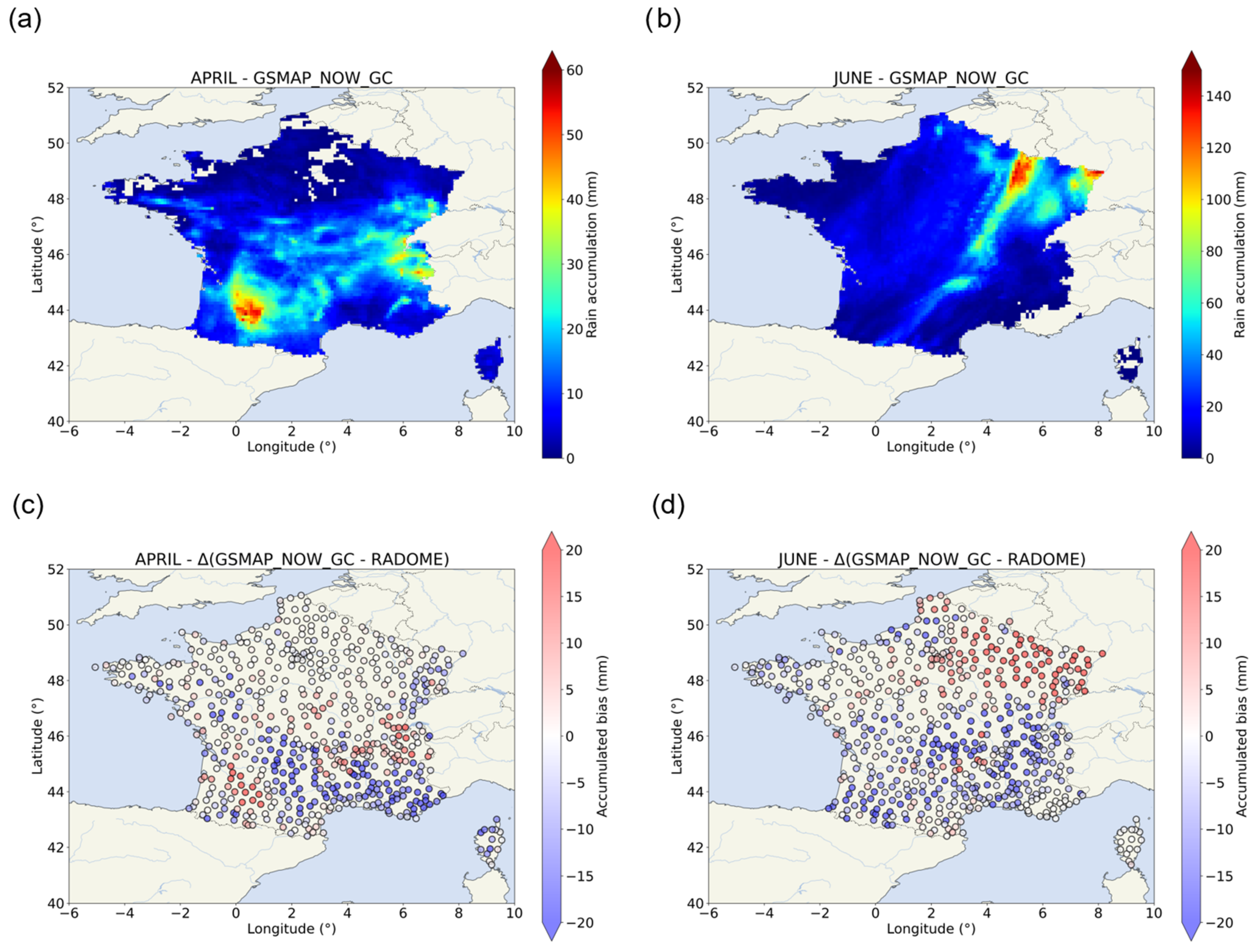
- The gauge-adjustment effectuated for the GSMaP-Now-GC and GSMaP-NRT-GC did not show a significant improvement in the quantification of both events;
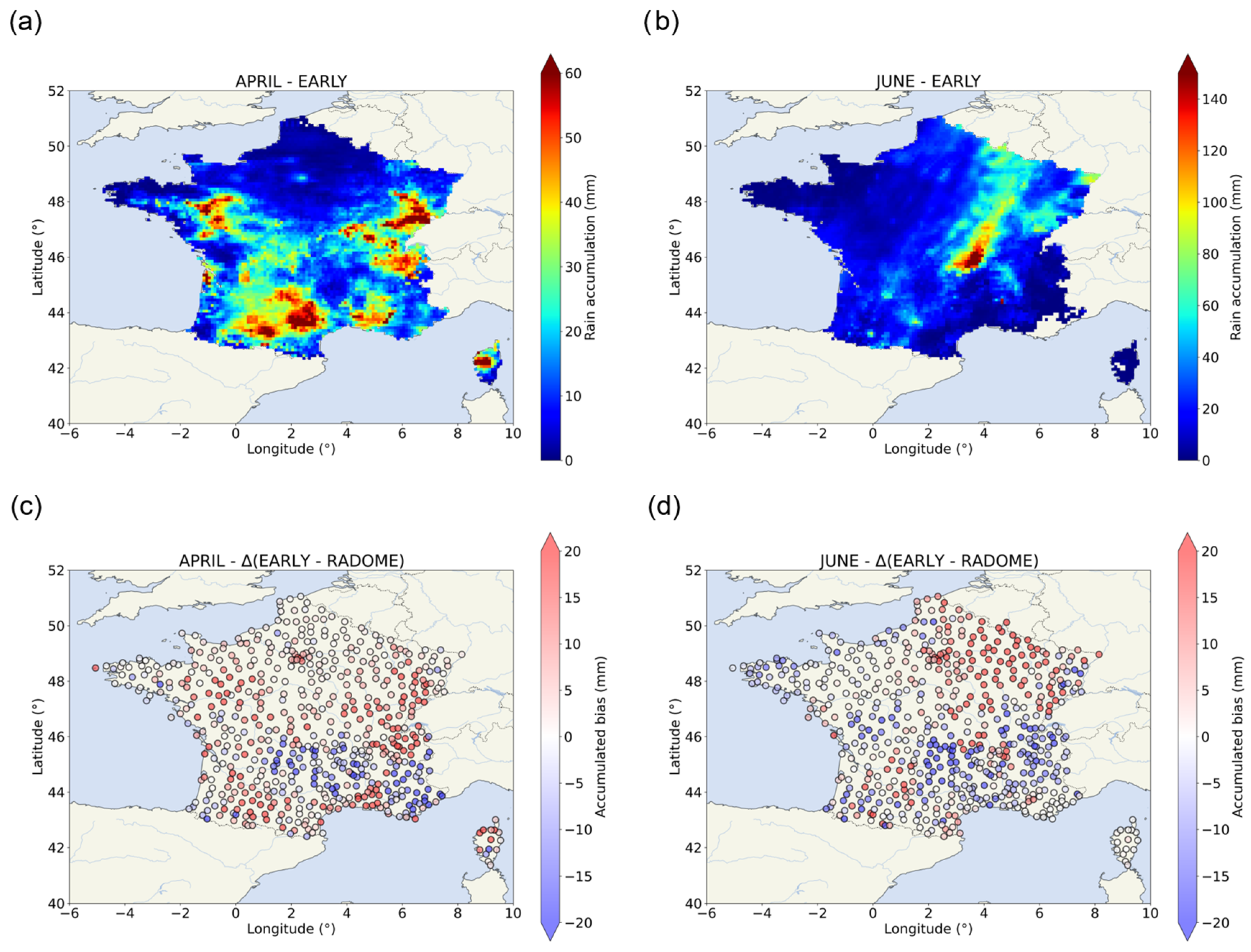
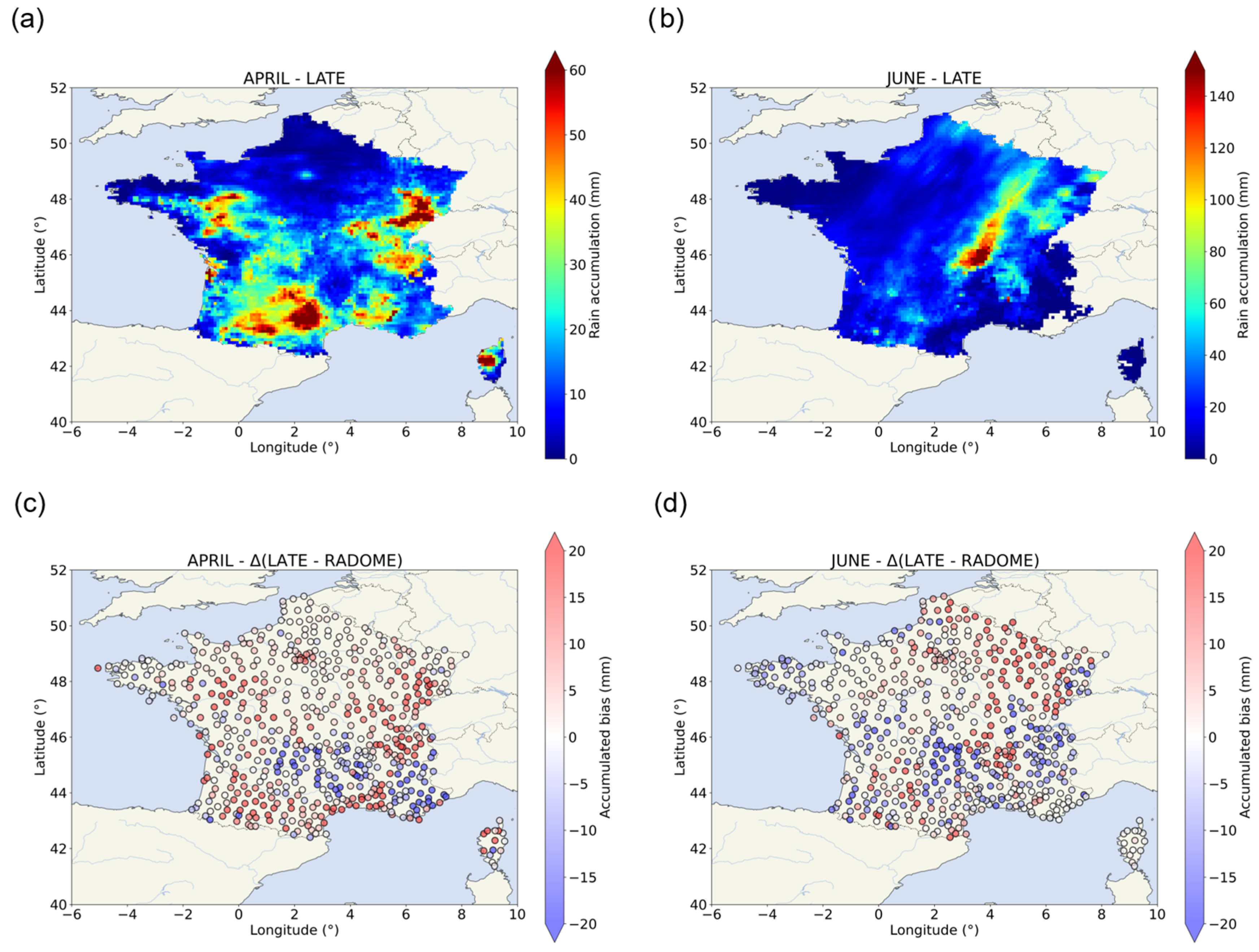
- IMERG-Early and IMERG-Late showed a trend to slightly overestimate the presence of rain, as shown by the overestimation recorded at low-rain-amount areas. They also tend to underestimate high rain-rate values but they well represented both case studies over the south regions of France;
- The reprocessing applied to IMERG-Late does not improve the estimations compared to IMERG-Early;
- CMORPH-RT showed traces of raw LEO satellite observation swaths over parts of the country. This was traduced by strong differences at the very-local scale, over the JUR area for example. CMORPH-RT showed low bias medians but CMORPH was better at the spatial representation of both events;
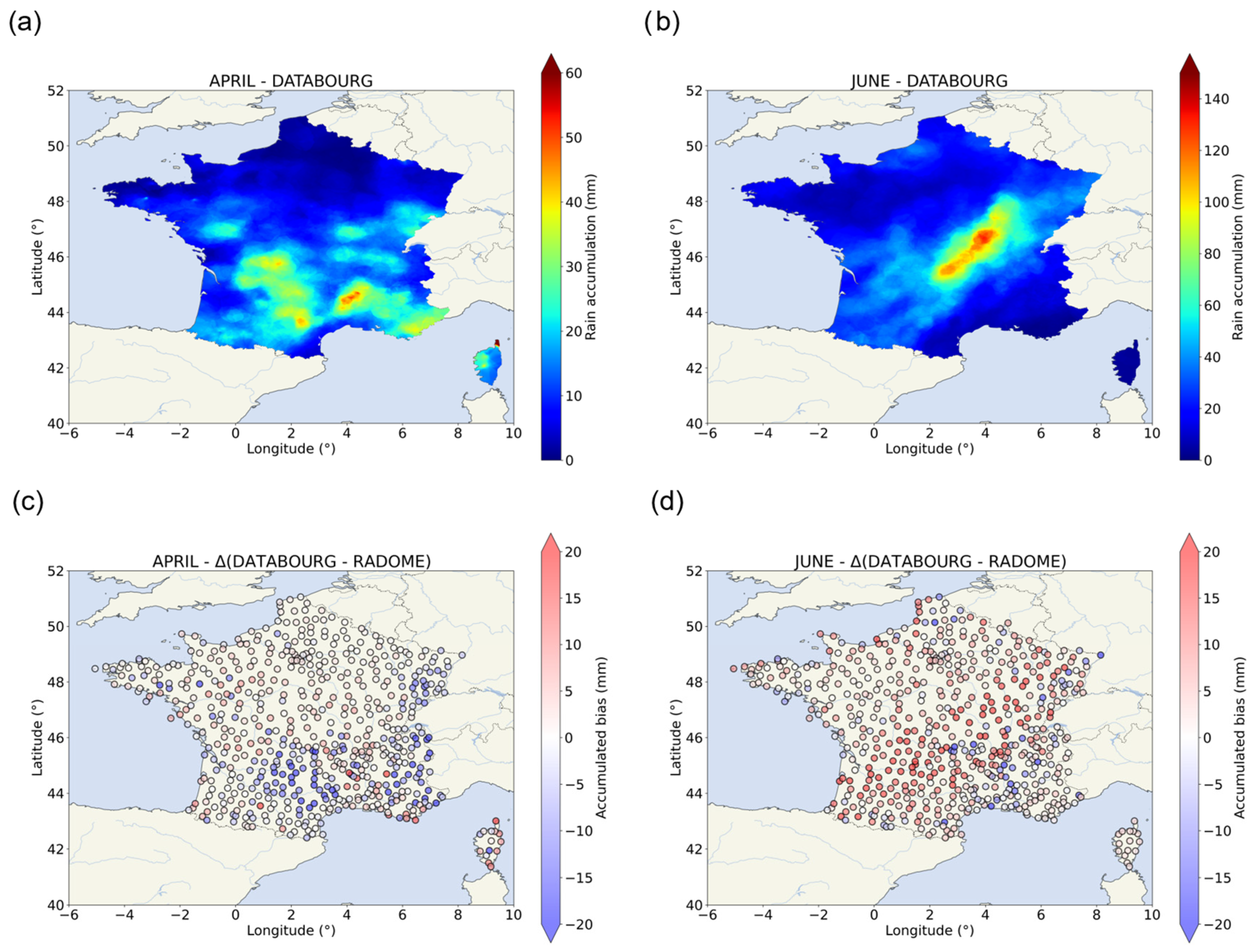
- Despite slightly overestimating during the June event, DATABOURG showed promising results with low biases for both cases with the highest spatiotemporal resolution (1 km2 and 5 min).
Supplementary Materials
Author Contributions
Funding
Institutional Review Board Statement
Informed Consent Statement
Data Availability Statement
Acknowledgments
Conflicts of Interest
Abbreviations
| AMW | Active MicroWave |
| ARAMIS | Application Radar À la Météorologie Infra-Synoptique |
| C/N | Carrier-to-Noise |
| CEV | Cévennes |
| CHRS | Center for Hydrometeorology and Remote Sensing |
| CMORPH | CPC MORPHing |
| CPC | Climate Prediction Center |
| DUR | Durance |
| EUMETNET | European METeorological NETwork |
| GEO | Geostationary Orbit |
| GHE | Global Hydro Estimator |
| GPM | Global Precipitation Measurement |
| GSMaP | Global Satellite Mapping of Precipitation |
| HE | Hydro Estimator |
| IMERG | Integrated Multi-satellitE Retrievals for GPM |
| IPCC | Intergovernmental Panel on Climate Change |
| IR | InfraRed |
| JAXA | Japan Aerospace Exploration Agency |
| JUR | Jura |
| LEO | Low Earth Orbit |
| MW | MicroWave |
| NASA | National Aeronautics and Space Administration |
| NESDIS | National Environmental Satellite, Data and Information Service |
| NMC | Northern Massif Central |
| NOAA | National Oceanic and Atmospheric Administration |
| NRT | Near Real Time |
| OPERA | Operational Program for Exchange of weather RAdar |
| PANTHERE | Projet ARAMIS Nouvelles Technologies en Hydrométéorologie Extension et REnouvellement |
| PCCS | PERSIANN Cloud Classification System |
| PCDR | PERSIANN Climate Data Record |
| PDIR | PERSIANN Dynamic Infrared Rain Rate |
| PERSIANN | Precipitation Estimation from Remotely Sensed Information using Artificial Neural Network |
| PMW | Passive MicroWave |
| R | Rain rate |
| RADOME | Réseau d’Acquisition de Données et d’Observation Météorologiques Etendues |
| RT | Real Time |
| SAL | Southern Alps |
| VPR | Vertical Profile of Reflectivity |
| WMC | Western Massif Central |
| Z | Reflectivity |
References
- Kidd, C.; Huffman, G.; Maggioni, V.; Chambon, P.; Oki, R. The Global Satellite Precipitation Constellation: Current Status and Future Requirements. Bull. Am. Meteorol. Soc. 2021, 102, E1844–E1861. [Google Scholar] [CrossRef]
- Kundzewicz, Z.W.; Kanae, S.; Seneviratne, S.I.; Handmer, J.; Nicholls, N.; Peduzzi, P.; Mechler, R.; Bouwer, L.M.; Arnell, N.; Mach, K.; et al. Flood Risk and Climate Change: Global and Regional Perspectives. Hydrol. Sci. J. 2014, 59, 1–28. [Google Scholar] [CrossRef]
- Volkert, H. Heavy Precipitation in the Alpine Region (HERA): Areal Rainfall Determination for Flood Warnings Through in-Situ Measureme Nts, Remote Sensing and Atmospheric Modelling. Meteorol. Atmos. Phys. 2000, 72, 73–85. [Google Scholar] [CrossRef][Green Version]
- Vicente-Serrano, S.M.; Beguería, S.; López-Moreno, J.I. A Multiscalar Drought Index Sensitive to Global Warming: The Standardized Precipitation Evapotranspiration Index. J. Clim. 2010, 23, 1696–1718. [Google Scholar] [CrossRef]
- IPCC. Climate Change 2022—Impacts, Adaptation and Vulnerability: Working Group II Contribution to the Sixth Assessment Report of the Intergovernmental Panel on Climate Change; Pörtner, H.-O., Roberts, D.C., Tignor, M., Poloczanska, E.S., Mintenbeck, K., Alegría, A., Craig, M., Langsdorf, S., Löschke, S., Möller, V., et al., Eds.; Cambridge University Press: Cambridge, UK, 2023. [Google Scholar] [CrossRef]
- Ren, M.; Xu, Z.; Pang, B.; Liu, W.; Liu, J.; Du, L.; Wang, R. Assessment of Satellite-Derived Precipitation Products for the Beijing Region. Remote Sens. 2018, 10, 1914. [Google Scholar] [CrossRef]
- Paprotny, D.; Sebastian, A.; Morales-Nápoles, O.; Jonkman, S.N. Trends in Flood Losses in Europe over the Past 150 Years. Nat. Commun. 2018, 9, 1985. [Google Scholar] [CrossRef]
- Cánovas-García, F.; García-Galiano, S.; Alonso-Sarría, F. Assessment of Satellite and Radar Quantitative Precipitation Estimates for Real Time Monitoring of Meteorological Extremes Over the Southeast of the Iberian Peninsula. Remote Sens. 2018, 10, 1023. [Google Scholar] [CrossRef]
- Paranunzio, R.; Chiarle, M.; Laio, F.; Nigrelli, G.; Turconi, L.; Luino, F. New Insights in the Relation between Climate and Slope Failures at High-Elevation Sites. Theor. Appl. Climatol. 2019, 137, 1765–1784. [Google Scholar] [CrossRef]
- Luino, F.; De Graff, J.; Roccati, A.; Biddoccu, M.; Cirio, C.G.; Faccini, F.; Turconi, L. Eighty Years of Data Collected for the Determination of Rainfall Threshold Triggering Shallow Landslides and Mud-Debris Flows in the Alps. Water 2020, 12, 133. [Google Scholar] [CrossRef]
- Kidd, C. Satellite Rainfall Climatology: A Review. Int. J. Climatol. 2001, 21, 1041–1066. [Google Scholar] [CrossRef]
- Sun, Q.; Miao, C.; Duan, Q.; Ashouri, H.; Sorooshian, S.; Hsu, K.-L. A Review of Global Precipitation Data Sets: Data Sources, Estimation, and Intercomparisons. Rev. Geophys. 2018, 56, 79–107. [Google Scholar] [CrossRef]
- du Châtelet, J.P. Aramis, le réseau français de radars pour la surveillance des précipitations. La Météorologie 2003, 40, 44–52. [Google Scholar] [CrossRef][Green Version]
- Huuskonen, A.; Saltikoff, E.; Holleman, I. The Operational Weather Radar Network in Europe. Bull. Am. Meteorol. Soc. 2014, 95, 897–907. [Google Scholar] [CrossRef]
- Kidd, C.; Levizzani, V. Status of Satellite Precipitation Retrievals. Hydrol. Earth Syst. Sci. 2011, 15, 1109–1116. [Google Scholar] [CrossRef]
- Yu, L.; Leng, G.; Python, A.; Peng, J. A Comprehensive Evaluation of Latest GPM IMERG V06 Early, Late and Final Precipitation Products across China. Remote Sens. 2021, 13, 1208. [Google Scholar] [CrossRef]
- Scofield, R.A.; Kuligowski, R.J. Status and Outlook of Operational Satellite Precipitation Algorithms for Extreme-Precipitation Events. Weather Forecast. 2003, 18, 1037–1051. [Google Scholar] [CrossRef]
- Hsu, K.; Gao, X.; Sorooshian, S.; Gupta, H.V. Precipitation Estimation from Remotely Sensed Information Using Artificial Neural Networks. J. Appl. Meteorol. Climatol. 1997, 36, 1176–1190. [Google Scholar] [CrossRef]
- Joyce, R.J.; Janowiak, J.E.; Arkin, P.A.; Xie, P. CMORPH: A Method That Produces Global Precipitation Estimates from Passive Microwave and Infrared Data at High Spatial and Temporal Resolution. J. Hydrometeorol. 2004, 5, 487–503. [Google Scholar] [CrossRef]
- Kubota, T.; Shige, S.; Hashizume, H.; Aonashi, K.; Takahashi, N.; Seto, S.; Hirose, M.; Takayabu, Y.N.; Ushio, T.; Nakagawa, K.; et al. Global Precipitation Map Using Satellite-Borne Microwave Radiometers by the GSMaP Project: Production and Validation. IEEE Trans. Geosci. Remote Sens. 2007, 45, 2259–2275. [Google Scholar] [CrossRef]
- Huffman, G.J.; Bolvin, D.T.; Braithwaite, D.; Hsu, K.; Joyce, R.; Kidd, C.; Nelkin, E.J.; Sorooshian, S.; Tan, J.; Xie, P. NASA Global Precipitation Easurement (GPM) Integrated Multi-SatellitE Retrievals for GPM (IMERG). NASA Algorithm Theoretical Basis Doc., Version 06, 38p. Available online: https://pmm.nasa.gov/sites/default/files/document_files/IMERG_ATBD_V06.pdf (accessed on 9 October 2023).
- Gharanjik, A.; Mishra, K.V.; Bhavani Shankar, M.R.; Ottersten, B. Learning-Based Rainfall Estimation via Communication Satellite Links. In Proceedings of the 2018 IEEE Statistical Signal Processing Workshop (SSP), Freiburg im Breisgau, Germany, 10–13 June 2018; pp. 130–134. [Google Scholar] [CrossRef]
- Gharanjik, A.; Bhavani Shankar, M.R.B.; Zimmer, F.; Ottersten, B. Centralized Rainfall Estimation Using Carrier to Noise of Satellite Communication Links. IEEE J. Sel. Areas Commun. 2018, 36, 1065–1073. [Google Scholar] [CrossRef]
- Tardieu, J.; Leroy, M. Radome, le réseau temps réel d’observation au sol de Météo-France. La Météorologie 2003, 40, 40–43. [Google Scholar] [CrossRef][Green Version]
- Guillou, Y. L’automatisation des observations météorologiques de surface à Météo-France. Une r-évolution. La Météorologie 2018, 100, 96–99. [Google Scholar] [CrossRef]
- Tabary, P. The New French Operational Radar Rainfall Product. Part I: Methodology. Weather Forecast. 2007, 22, 393–408. [Google Scholar] [CrossRef]
- Figueras i Ventura, J.; Tabary, P. The New French Operational Polarimetric Radar Rainfall Rate Product. J. Appl. Meteorol. Climatol. 2013, 52, 1817–1835. [Google Scholar] [CrossRef]
- Saltikoff, E.; Haase, G.; Delobbe, L.; Gaussiat, N.; Martet, M.; Idziorek, D.; Leijnse, H.; Novák, P.; Lukach, M.; Stephan, K. OPERA the Radar Project. Atmosphere 2019, 10, 320. [Google Scholar] [CrossRef]
- Le Bastard, T.; Caumont, O.; Gaussiat, N.; Karbou, F. Combined Use of Volume Radar Observations and High-Resolution Numerical Weather Predictions to Estimate Precipitation at the Ground: Methodology and Proof of Concept. Atmos. Meas. Tech. 2019, 12, 5669–5684. [Google Scholar] [CrossRef]
- Chochon, R.; Martin, N.; Lebourg, T.; Vidal, M. Analysis of Extreme Precipitation during the Mediterranean Event Associated with the Alex Storm in the Alpes-Maritimes: Atmospheric Mechanisms and Resulting Rainfall. In Proceedings of the SimHydro 2021: Models for Complex and Global Water Issues, Nice, France, 16–18 June 2021; Available online: https://hal.science/hal-03374712 (accessed on 9 October 2023).
- Qiu, Y. Multiscale Assessment of Hydrological Responses of Nature-Based Solutions to Improve Urban Resilience. Ph.D. Thesis, École des Ponts ParisTech, Champs-sur-Marne, France, 2021. Available online: https://pastel.hal.science/tel-03404617 (accessed on 9 October 2023).
- Park, S.; Berenguer, M.; Sempere-Torres, D. Long-Term Analysis of Gauge-Adjusted Radar Rainfall Accumulations at European Scale. J. Hydrol. 2019, 573, 768–777. [Google Scholar] [CrossRef]
- Nguyen, P.; Shearer, E.J.; Ombadi, M.; Afzali Gorooh, V.; Hsu, K.; Sorooshian, S.; Logan, W.S.; Ralph, M. PERSIANN Dynamic Infrared–Rain Rate Model (PDIR) for High-Resolution, Real-Time Satellite Precipitation Estimation. Bull. Am. Meteorol. Soc. 2020, 101, E286–E302. [Google Scholar] [CrossRef]
- Arkin, P.A.; Meisner, B.N. The Relationship between Large-Scale Convective Rainfall and Cold Cloud over the Western Hemisphere during 1982-84. Mon. Weather Rev. 1987, 115, 51–74. [Google Scholar] [CrossRef]
- Berthomier, L.; Perier, L. Espresso: A Global Deep Learning Model to Estimate Precipitation from Satellite Observations. Meteorology 2023, 2, 421–444. [Google Scholar] [CrossRef]
- Shamir, E.; Rimmer, A.; Georgakakos, K.P. The Use of an Orographic Precipitation Model to Assess the Precipitation Spatial Distribution in Lake Kinneret Watershed. Water 2016, 8, 591. [Google Scholar] [CrossRef]
- Hobouchian, M.P.; Salio, P.; Skabar, Y.G.; Vila, D.; Garreaud, R. Assessment of Satellite Precipitation Estimates over the Slopes of the Subtropical Andes. Atmos. Res. 2017, 190, 43–54. [Google Scholar] [CrossRef]
- Georgakakos, K.; Modrick, T.; Spencer, C. Operational Microwave-Adjusted Hydro-Estimator to Support Flash Flood Assessments Worldwide. In Proceedings of the AGU Fall Meeting 2021, New Orleans, LA, USA, 13–17 December 2021; p. H13H-01. Available online: https://ui.adsabs.harvard.edu/abs/2021AGUFM.H13H..01G (accessed on 9 October 2023).
- Nguyen, P.; Ombadi, M.; Afzali Gorooh, V.; Shearer, E.J.; Sadeghi, M.; Sorooshian, S.; Hsu, K.; Bolvin, D.; Ralph, M.F. PERSIANN Dynamic Infrared–Rain Rate (PDIR-Now): A Near-Real-Time, Quasi-Global Satellite Precipitation Dataset. J. Hydrometeorol. 2020, 21, 2893–2906. [Google Scholar] [CrossRef]
- Hong, Y.; Hsu, K.-L.; Sorooshian, S.; Gao, X. Precipitation Estimation from Remotely Sensed Imagery Using an Artificial Neural Network Cloud Classification System. J. Appl. Meteorol. Climatol. 2004, 43, 1834–1853. [Google Scholar] [CrossRef]
- Fick, S.E.; Hijmans, R.J. WorldClim 2: New 1-Km Spatial Resolution Climate Surfaces for Global Land Areas. Int. J. Climatol. 2017, 37, 4302–4315. [Google Scholar] [CrossRef]
- Ashouri, H.; Hsu, K.-L.; Sorooshian, S.; Braithwaite, D.K.; Knapp, K.R.; Cecil, L.D.; Nelson, B.R.; Prat, O.P. PERSIANN-CDR: Daily Precipitation Climate Data Record from Multisatellite Observations for Hydrological and Climate Studies. Bull. Am. Meteorol. Soc. 2015, 96, 69–83. [Google Scholar] [CrossRef]
- Kummerow, C.D. Introduction to Passive Microwave Retrieval Methods. In Satellite Precipitation Measurement: Volume 1; Levizzani, V., Kidd, C., Kirschbaum, D.B., Kummerow, C.D., Nakamura, K., Turk, F.J., Eds.; Advances in Global Change Research; Springer International Publishing: Cham, Switzerland, 2020; pp. 123–140. [Google Scholar] [CrossRef]
- Kidd, C.; Matsui, T.; Blackwell, W.; Braun, S.; Leslie, R.; Griffith, Z. Precipitation Estimation from the NASA TROPICS Mission: Initial Retrievals and Validation. Remote Sens. 2022, 14, 2992. [Google Scholar] [CrossRef]
- Battaglia, A.; Kollias, P.; Dhillon, R.; Roy, R.; Tanelli, S.; Lamer, K.; Grecu, M.; Lebsock, M.; Watters, D.; Mroz, K.; et al. Spaceborne Cloud and Precipitation Radars: Status, Challenges, and Ways Forward. Rev. Geophys. 2020, 58, e2019RG000686. [Google Scholar] [CrossRef] [PubMed]
- Watters, D.; Battaglia, A.; Mroz, K.; Tridon, F. Validation of the GPM Version-5 Surface Rainfall Products over Great Britain and Ireland. J. Hydrometeorol. 2018, 19, 1617–1636. [Google Scholar] [CrossRef]
- Joyce, R.J.; Xie, P.; Yarosh, Y.; Janowiak, J.E.; Arkin, P.A. CMORPH: A “Morphing” Approach for High Resolution Precipitation Product Generation. In Satellite Rainfall Applications for Surface Hydrology; Gebremichael, M., Hossain, F., Eds.; Springer: Dordrecht, The Netherlands, 2010; pp. 23–37. [Google Scholar] [CrossRef]
- Ushio, T.; Sasashige, K.; Kubota, T.; Shige, S.; Okamoto, K.; Aonashi, K.; Inoue, T.; Takahashi, N.; Iguchi, T.; Kachi, M.; et al. A Kalman Filter Approach to the Global Satellite Mapping of Precipitation (GSMaP) from Combined Passive Microwave and Infrared Radiometric Data. J. Meteorol. Soc. Japan. Ser. II 2009, 87A, 137–151. [Google Scholar] [CrossRef]
- Kubota, T.; Aonashi, K.; Ushio, T.; Shige, S.; Takayabu, Y.N.; Kachi, M.; Arai, Y.; Tashima, T.; Masaki, T.; Kawamoto, N.; et al. Global Satellite Mapping of Precipitation (GSMaP) Products in the GPM Era. In Satellite Precipitation Measurement: Volume 1; Levizzani, V., Kidd, C., Kirschbaum, D.B., Kummerow, C.D., Nakamura, K., Turk, F.J., Eds.; Advances in Global Change Research; Springer International Publishing: Cham, Switzerland, 2020; pp. 355–373. [Google Scholar] [CrossRef]
- Shi, J.; Wang, B.; Wang, G.; Yuan, F.; Shi, C.; Zhou, X.; Zhang, L.; Zhao, C. Are the Latest GSMaP Satellite Precipitation Products Feasible for Daily and Hourly Discharge Simulations in the Yellow River Source Region? Remote Sens. 2021, 13, 4199. [Google Scholar] [CrossRef]
- Ramadhan, R.; Marzuki, M.; Yusnaini, H.; Muharsyah, R.; Tangang, F.; Vonnisa, M.; Harmadi, H. A Preliminary Assessment of the GSMaP Version 08 Products over Indonesian Maritime Continent against Gauge Data. Remote Sens. 2023, 15, 1115. [Google Scholar] [CrossRef]
- O, S.; Foelsche, U.; Kirchengast, G.; Fuchsberger, J.; Tan, J.; Petersen, W.A. Evaluation of GPM IMERG Early, Late, and Final Rainfall Estimates Using WegenerNet Gauge Data in Southeastern Austria. Hydrol. Earth Syst. Sci. 2017, 21, 6559–6572. [Google Scholar] [CrossRef]
- Mishra, K.V.; Gharanjik, A.; Bhavani Shankar, M.R.; Ottersten, B. Deep Learning Framework for Precipitation Retrievals from Communication Satellites; Ede-Wageningen: Ede, The Netherlands, 2018. [Google Scholar]
- Mishra, K.V.; Chandrasekar, V.; Nguyen, C.; Vega, M. The Signal Processor System for the NASA Dual-Frequency Dual-Polarized Doppler Radar. In Proceedings of the 2012 IEEE International Geoscience and Remote Sensing Symposium, Munich, Germany, 22–27 July 2012; pp. 4774–4777. [Google Scholar] [CrossRef]
- Zhang, X.; Lu, X.; Wang, X. Comparison of Spatial Interpolation Methods Based on Rain Gauges for Annual Precipitation on the Tibetan Plateau. Pol. J. Environ. Stud. 2016, 25, 1339–1345. [Google Scholar] [CrossRef] [PubMed]
- Thiessen, A.H. Precipitation averages for large areas. Mon. Weather Rev. 1911, 39, 1082–1089. [Google Scholar] [CrossRef]
- Vicente-Serrano, S.M.; Saz-Sánchez, M.A.; Cuadrat, J.M. Comparative Analysis of Interpolation Methods in the Middle Ebro Valley (Spain): Application to Annual Precipitation and Temperature. Clim. Res. 2003, 24, 161–180. [Google Scholar] [CrossRef]
- Lebrenz, H.; Bárdossy, A. Geostatistical Interpolation by Quantile Kriging. Hydrol. Earth Syst. Sci. 2019, 23, 1633–1648. [Google Scholar] [CrossRef]
- Saemian, P.; Hosseini-Moghari, S.-M.; Fatehi, I.; Shoarinezhad, V.; Modiri, E.; Tourian, M.J.; Tang, Q.; Nowak, W.; Bárdossy, A.; Sneeuw, N. Comprehensive Evaluation of Precipitation Datasets over Iran. J. Hydrol. 2021, 603, 127054. [Google Scholar] [CrossRef]
- Thiemig, V.; Rojas, R.; Zambrano-Bigiarini, M.; Levizzani, V.; Roo, A.D. Validation of Satellite-Based Precipitation Products over Sparsely Gauged African River Basins. J. Hydrometeorol. 2012, 13, 1760–1783. [Google Scholar] [CrossRef]
- Zambrano-Bigiarini, M.; Nauditt, A.; Birkel, C.; Verbist, K.; Ribbe, L. Temporal and Spatial Evaluation of Satellite-Based Rainfall Estimates across the Complex Topographical and Climatic Gradients of Chile. Hydrol. Earth Syst. Sci. 2017, 21, 1295–1320. [Google Scholar] [CrossRef]
- Llauca, H.; Lavado-Casimiro, W.; León, K.; Jimenez, J.; Traverso, K.; Rau, P. Assessing Near Real-Time Satellite Precipitation Products for Flood Simulations at Sub-Daily Scales in a Sparsely Gauged Watershed in Peruvian Andes. Remote Sens. 2021, 13, 826. [Google Scholar] [CrossRef]
- Hersbach, H.; Bell, B.; Berrisford, P.; Hirahara, S.; Horányi, A.; Muñoz-Sabater, J.; Nicolas, J.; Peubey, C.; Radu, R.; Schepers, D.; et al. The ERA5 Global Reanalysis. Q. J. R. Meteorol. Soc. 2020, 146, 1999–2049. [Google Scholar] [CrossRef]
- Afzali Gorooh, V.; Shearer, E.J.; Nguyen, P.; Hsu, K.; Sorooshian, S.; Cannon, F.; Ralph, M. Performance of New Near-Real-Time PERSIANN Product (PDIR-Now) for Atmospheric River Events over the Russian River Basin, California. J. Hydrometeorol. 2022, 23, 1899–1911. [Google Scholar] [CrossRef]
- Huang, W.-R.; Liu, P.-Y.; Hsu, J. Multiple Timescale Assessment of Wet Season Precipitation Estimation over Taiwan Using the PERSIANN Family Products. Int. J. Appl. Earth Obs. Geoinf. 2021, 103, 102521. [Google Scholar] [CrossRef]
- Rachdane, M.; Khalki, E.M.E.; Saidi, M.E.; Nehmadou, M.; Ahbari, A.; Tramblay, Y. Comparison of High-Resolution Satellite Precipitation Products in Sub-Saharan Morocco. Water 2022, 14, 3336. [Google Scholar] [CrossRef]
- Hisam, E.; Danandeh Mehr, A.; Alganci, U.; Zafer Seker, D. Comprehensive Evaluation of Satellite-Based and Reanalysis Precipitation Products over the Mediterranean Region in Turkey. Adv. Space Res. 2023, 71, 3005–3021. [Google Scholar] [CrossRef]
- Bieliński, T. A Parallax Shift Effect Correction Based on Cloud Height for Geostationary Satellites and Radar Observations. Remote Sens. 2020, 12, 365. [Google Scholar] [CrossRef]
- Schleiss, M.; Olsson, J.; Berg, P.; Niemi, T.; Kokkonen, T.; Thorndahl, S.; Nielsen, R.; Ellerbæk Nielsen, J.; Bozhinova, D.; Pulkkinen, S. The Accuracy of Weather Radar in Heavy Rain: A Comparative Study for Denmark, the Netherlands, Finland and Sweden. Hydrol. Earth Syst. Sci. 2020, 24, 3157–3188. [Google Scholar] [CrossRef]
- Di Curzio, D.; Di Giovanni, A.; Lidori, R.; Montopoli, M.; Rusi, S. Comparing Rain Gauge and Weather RaDAR Data in the Estimation of the Pluviometric Inflow from the Apennine Ridge to the Adriatic Coast (Abruzzo Region, Central Italy). Hydrology 2022, 9, 225. [Google Scholar] [CrossRef]
- Rojas, Y.; Minder, J.R.; Campbell, L.S.; Massmann, A.; Garreaud, R. Assessment of GPM IMERG Satellite Precipitation Estimation and Its Dependence on Microphysical Rain Regimes over the Mountains of South-Central Chile. Atmos. Res. 2021, 253, 105454. [Google Scholar] [CrossRef]
- Giorgi, F.; Torma, C.; Coppola, E.; Ban, N.; Schär, C.; Somot, S. Enhanced Summer Convective Rainfall at Alpine High Elevations in Response to Climate Warming. Nat. Geosci. 2016, 9, 584–589. [Google Scholar] [CrossRef]
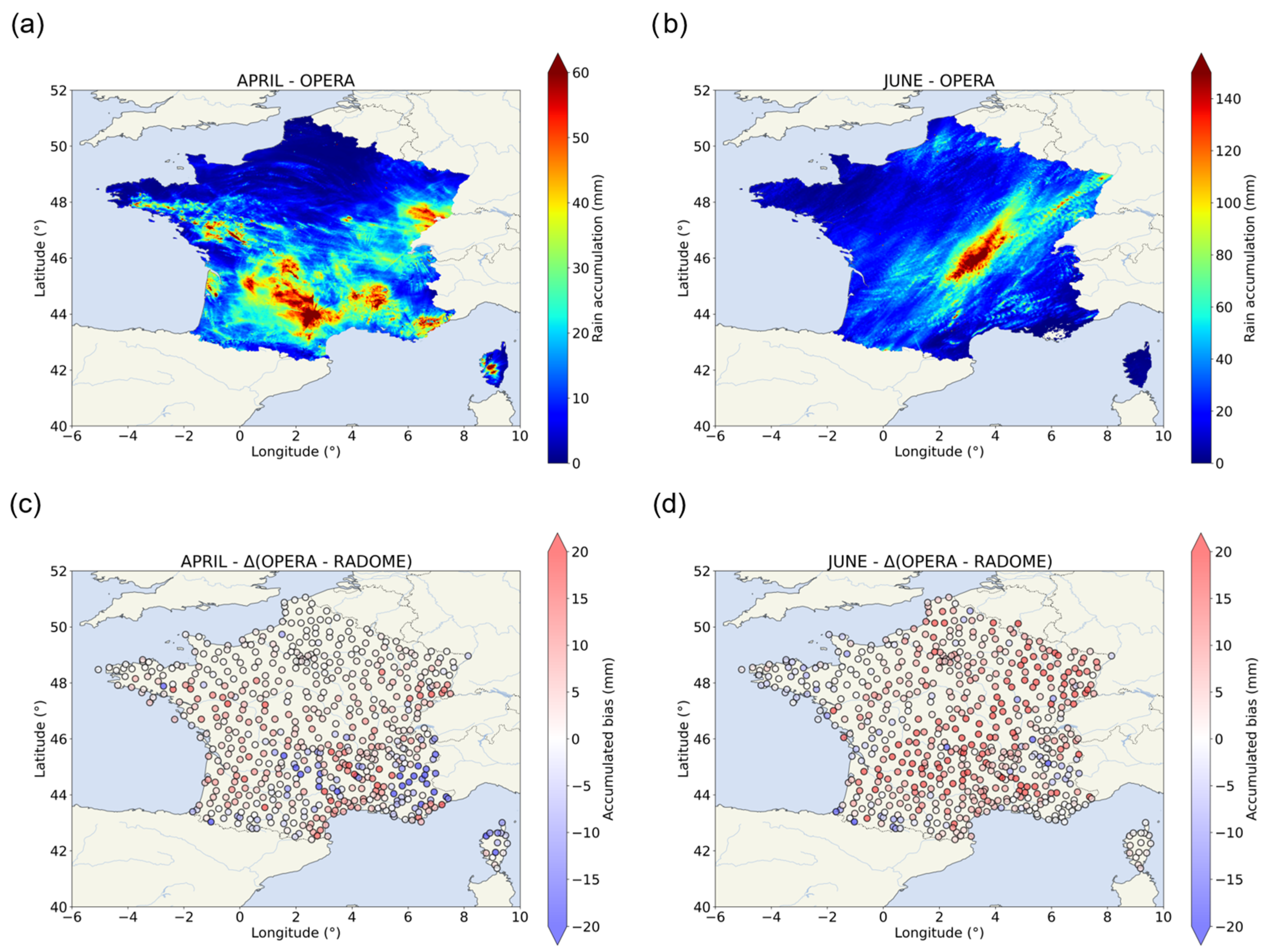
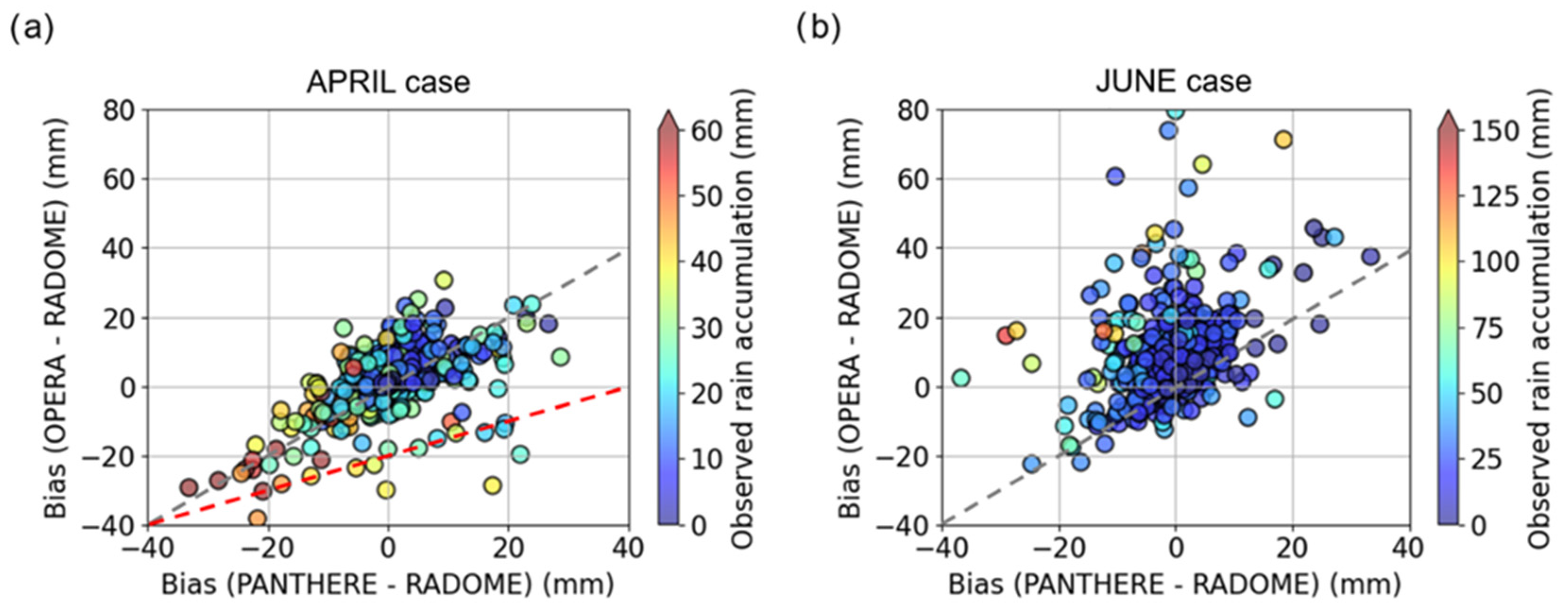
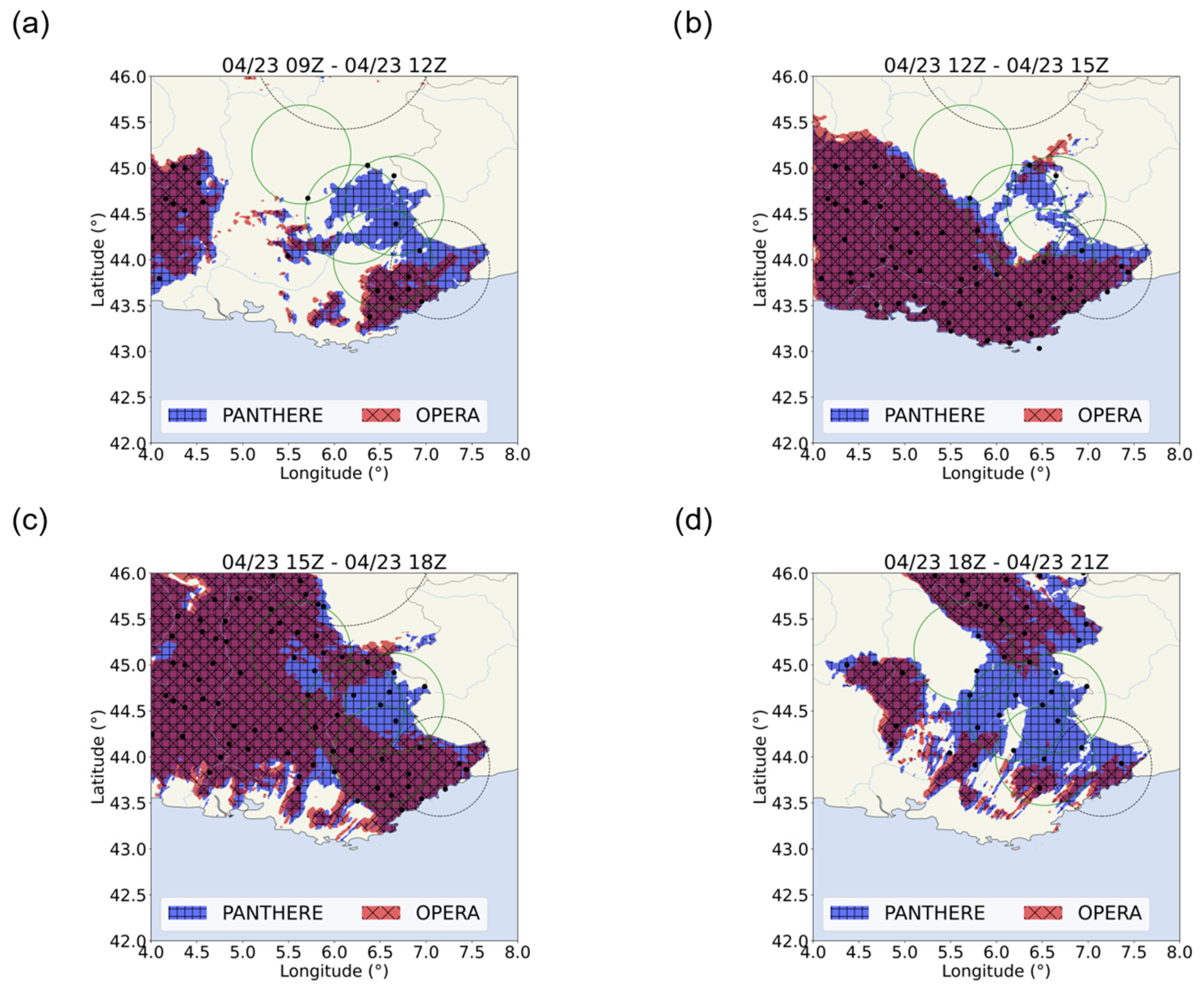
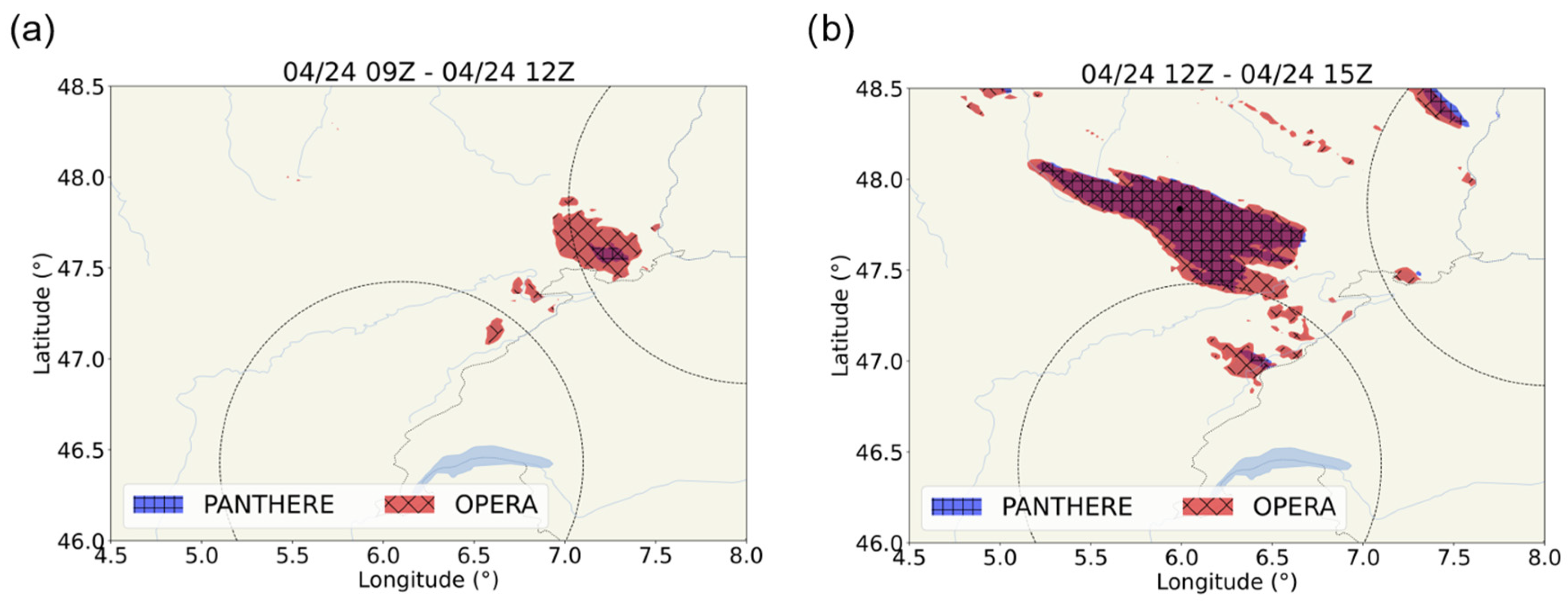

| Dataset | Type of Data | Spatial Coverage | Spatial Resolution | Temporal Resolution | Data Latency | Availability |
|---|---|---|---|---|---|---|
| RADOME | Rain gauges network | France | - | 1 h | Real-time | https://donneespubliques.meteofrance.fr, accessed on 19 November 2023 |
| PANTHERE | Radar network | France | 1 km2 | 15 min | Real-time | https://donneespubliques.meteofrance.fr, accessed on 19 November 2023 |
| OPERA | Radar network | Europe | 4 km2 | 15 min | Real-time | https://portail-api.meteofrance.fr/web/fr/, accessed on 19 November 2023 |
| IMERG-Early | Satellite | 60° N–60° S | 0.1° × 0.1° | 30 min | 4 h | https://disc.gsfc.nasa.gov/datasets/GPM_3IMERGHHE_06/summary, accessed on 19 November 2023 |
| IMERG-Late | Satellite | 60° N–60° S | 0.1° × 0.1° | 30 min | 14 h | https://disc.gsfc.nasa.gov/datasets/GPM_3IMERGHHL_06/summary, accessed on 19 November 2023 |
| CMORPH-RT | Satellite | 60° N–60° S | 0.08° × 0.08° | 30 min | 3 h | https://ftp.cpc.ncep.noaa.gov/precip/CMORPH_RT/, accessed on 19 November 2023 |
| CMORPH | Satellite | 60° N–60° S | 0.08° × 0.08° | 30 min | 18 h | https://ftp.cpc.ncep.noaa.gov/precip/CMORPH_V0.x/, accessed on 19 November 2023 |
| GSMaP-Now | Satellite | 60° N–60° S | 0.1° × 0.1° | 30 min | Real-time | https://sharaku.eorc.jaxa.jp/GSMaP_NOW/, accessed on 19 November 2023 |
| GSMaP-Now-GC | Satellite | 60° N–60° S | 0.1° × 0.1° | 30 min | Real-time | https://sharaku.eorc.jaxa.jp/GSMaP_NOW/, accessed on 19 November 2023 |
| GSMaP-NRT | Satellite | 60° N–60° S | 0.1° × 0.1° | 1 h | 4 h | https://sharaku.eorc.jaxa.jp/GSMaP/, accessed on 19 November 2023 |
| GSMAP-NRT-GC | Satellite | 60° N–60° S | 0.1° × 0.1° | 1 h | 4 h | https://sharaku.eorc.jaxa.jp/GSMaP/, accessed on 19 November 2023 |
| GHE | Satellite | 60° N–60° S | 0.04° × 0.04° | 15 min | 2 h | https://www.noaa.gov/nodd/datasets, accessed on 19 November 2023 |
| PDIR | Satellite | 60° N–60° S | 0.04° × 0.04° | 1 h | 2 h | https://persiann.eng.uci.edu/CHRSdata/PDIRNow/netcdf_1h/, accessed on 19 November 2023 |
| DATABOURG | Satellite | France | 1 km2 | 5 min | Real-time | https://databourg.com/, accessed on 19 November 2023 |
| Dataset | April | June | ||||||||||
|---|---|---|---|---|---|---|---|---|---|---|---|---|
| WMC | SAL | DUR | CEV | JUR | NMC | |||||||
| Max | Dist. | Max | Dist. | Max | Dist. | Max | Dist. | Max | Dist. | Max | Dist. | |
| RADOME | 75.90 | - | 59.50 | - | 62.50 | - | 85.10 | - | 31.80 | - | 136.70 | - |
| PANTHERE | 98.10 | 225.54 | 89.00 | 32.29 | 69.50 | 107.99 | 72.10 | 10.41 | 44.10 | 14.18 | 204.60 | 74.64 |
| OPERA | 131.85 | 182.19 | 82.56 | 26.32 | 76.07 | 53.48 | 199.62 | 26.46 | 63.41 | 22.42 | 293.23 | 71.81 |
| PDIR | 62.42 | 239.07 | 39.24 | 73.20 | 41.12 | 111.73 | 28.17 | 32.47 | 31.33 | 15.07 | 76.60 | 9.64 |
| GHE | 70.45 | 119.27 | 168.26 | 75.51 | 208.32 | 18.94 | 72.12 | 30.39 | 54.72 | 41.78 | 83.68 | 9.44 |
| EARLY | 96.69 | 11.88 | 34.24 | 37.23 | 101.47 | 147.30 | 63.53 | 129.90 | 124.63 | 53.64 | 223.86 | 69.93 |
| LATE | 91.03 | 17.79 | 40.17 | 37.23 | 110.97 | 147.30 | 54.42 | 93.59 | 116.43 | 53.64 | 211.99 | 69.93 |
| GSMaP-Now | 72.24 | 161.98 | 43.98 | 83.90 | 50.79 | 167.46 | 38.41 | 80.11 | 45.57 | 153.07 | 82.83 | 126.89 |
| GSMaP-Now-GC | 56.57 | 161.98 | 30.99 | 83.90 | 38.09 | 167.46 | 29.44 | 80.11 | 39.87 | 153.07 | 82.43 | 126.89 |
| GSMaP-NRT | 50.64 | 132.31 | 85.73 | 70.57 | 85.73 | 57.61 | 37.40 | 107.70 | 44.60 | 103.73 | 83.97 | 77.85 |
| GSMAP-NRT-GC | 62.71 | 132.31 | 84.53 | 70.57 | 84.53 | 57.61 | 43.17 | 107.70 | 59.99 | 103.73 | 51.15 | 77.85 |
| CMORPH-RT | 62.13 | 181.98 | 36.36 | 48.17 | 52.10 | 138.10 | 26.42 | 90.76 | 66.97 | 43.55 | 61.77 | 46.20 |
| CMORPH | 49.60 | 23.72 | 31.00 | 33.18 | 29.70 | 28.22 | 27.00 | 90.76 | 37.70 | 51.76 | 129.20 | 83.22 |
| DATABOURG | 43.62 | 6.68 | 39.49 | 34.89 | 30.46 | 16.07 | 51.70 | 15.18 | 27.17 | 108.96 | 133.23 | 157.18 |
| Dataset | April | June | ||||||||||
|---|---|---|---|---|---|---|---|---|---|---|---|---|
| WMC | SAL | DUR | CEV | JUR | NMC | |||||||
| Median | Mean Bias | Median | Mean Bias | Median | Mean Bias | Median | Mean Bias | Median | Mean Bias | Median | Mean Bias | |
| RADOME | 26.60 | - | 31.40 | - | 23.50 | - | 22.30 | - | 25.40 | - | 35.70 | - |
| PANTHERE | 24.80 | −2.14 | 30.50 | +1.95 | 28.00 | +0.05 | 30.10 | +6.89 | 22.60 | −0.57 | 35.00 | −0.73 |
| OPERA | 29.14 | +1.09 | 22.26 | −3.70 | 16.11 | −9.13 | 29.11 | +5.15 | 27.63 | +6.51 | 50.03 | +14.13 |
| PDIR | 10.35 | −16.17 | 9.63 | −22.26 | 16.06 | −9.70 | 7.22 | −17.77 | 15.21 | −8.73 | 24.79 | −18.02 |
| GHE | 30.10 | +1.25 | 50.46 | +12.22 | 41.88 | +17.07 | 32.53 | +5.42 | 36.10 | +11.29 | 33.44 | −12.86 |
| EARLY | 29.97 | +0.47 | 13.01 | −15.51 | 15.58 | −7.87 | 17.71 | −4.33 | 40.85 | +20.87 | 28.42 | −4.55 |
| LATE | 30.41 | +0.89 | 13.39 | −14.99 | 15.65 | −7.82 | 19.96 | −3.63 | 41.69 | +24.69 | 32.25 | −0.58 |
| GSMaP-Now | 23.00 | −3.69 | 9.19 | −21.05 | 14.61 | −10.68 | 12.04 | −11.99 | 18.65 | −4.78 | 19.77 | −19.63 |
| GSMaP-Now-GC | 17.96 | −8.95 | 5.98 | −24.44 | 10.53 | −15.05 | 8.91 | −15.42 | 18.05 | −5.54 | 19.43 | −20.57 |
| GSMaP-NRT | 16.68 | −12.22 | 21.12 | −14.06 | 16.61 | −10.64 | 16.74 | −8.67 | 19.27 | −3.72 | 26.02 | −15.73 |
| GSMAP-NRT-GC | 20.42 | −8.47 | 19.57 | −15.46 | 17.49 | −10.39 | 18.69 | −6.51 | 26.09 | +3.84 | 15.85 | −26.17 |
| CMORPH-RT | 19.19 | −8.34 | 12.53 | −14.99 | 16.23 | −7.53 | 14.61 | −10.83 | 27.17 | +12.84 | 20.78 | −19.26 |
| CMORPH | 20.90 | −8.20 | 11.50 | −16.78 | 12.90 | −14.53 | 14.80 | −11.43 | 23.50 | −0.91 | 37.90 | +1.25 |
| DATABOURG | 21.68 | −6.83 | 27.05 | −4.35 | 22.25 | −6.59 | 20.14 | −3.11 | 18.47 | −5.54 | 49.86 | +8.94 |
Disclaimer/Publisher’s Note: The statements, opinions and data contained in all publications are solely those of the individual author(s) and contributor(s) and not of MDPI and/or the editor(s). MDPI and/or the editor(s) disclaim responsibility for any injury to people or property resulting from any ideas, methods, instructions or products referred to in the content. |
© 2023 by the authors. Licensee MDPI, Basel, Switzerland. This article is an open access article distributed under the terms and conditions of the Creative Commons Attribution (CC BY) license (https://creativecommons.org/licenses/by/4.0/).
Share and Cite
Causse, A.; Planche, C.; Buisson, E.; Baray, J.-L. Evaluation of Rain Estimates from Several Ground-Based Radar Networks and Satellite Products for Two Cases Observed over France in 2022. Atmosphere 2023, 14, 1726. https://doi.org/10.3390/atmos14121726
Causse A, Planche C, Buisson E, Baray J-L. Evaluation of Rain Estimates from Several Ground-Based Radar Networks and Satellite Products for Two Cases Observed over France in 2022. Atmosphere. 2023; 14(12):1726. https://doi.org/10.3390/atmos14121726
Chicago/Turabian StyleCausse, Antoine, Céline Planche, Emmanuel Buisson, and Jean-Luc Baray. 2023. "Evaluation of Rain Estimates from Several Ground-Based Radar Networks and Satellite Products for Two Cases Observed over France in 2022" Atmosphere 14, no. 12: 1726. https://doi.org/10.3390/atmos14121726
APA StyleCausse, A., Planche, C., Buisson, E., & Baray, J.-L. (2023). Evaluation of Rain Estimates from Several Ground-Based Radar Networks and Satellite Products for Two Cases Observed over France in 2022. Atmosphere, 14(12), 1726. https://doi.org/10.3390/atmos14121726


