
Effects of Low-Frequency Oscillation at Different Latitudes on Summer Precipitation in Flood and Drought Years in Southern China


Abstract
1. Introduction
2. Data and Methods
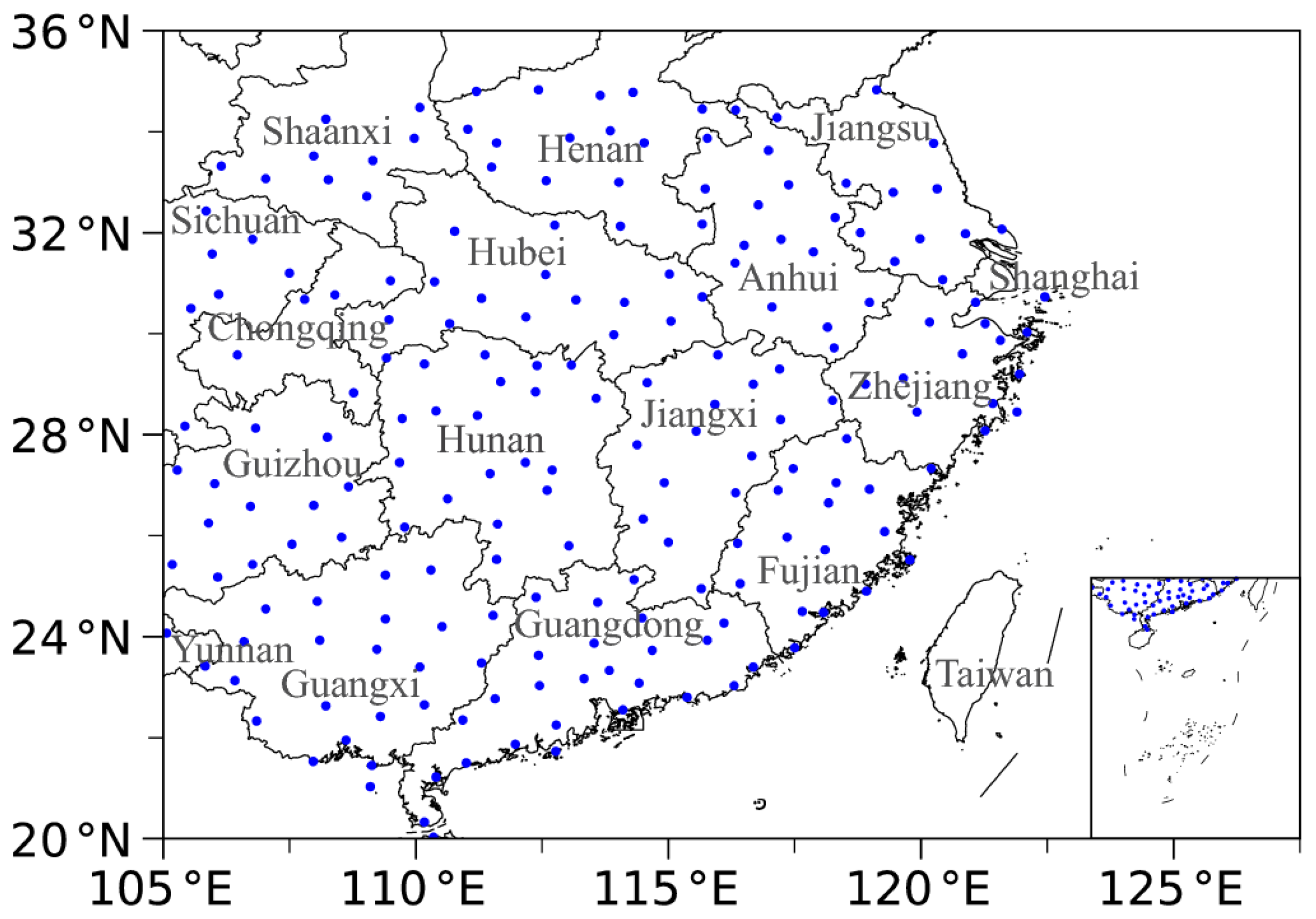
2.1. Data
2.2. Methods
2.2.1. The Morlet Wavelet Analysis Method
2.2.2. The Butterworth Band-Pass Filter
2.2.3. The Composite Analysis Method
2.2.4. The Inverse Algorithm
2.2.5. The Lead–Lag Correlation Method
2.2.6. The Calculation Method for the Water Vapor Budget
2.2.7. The Effective Degrees of Freedom
3. Results
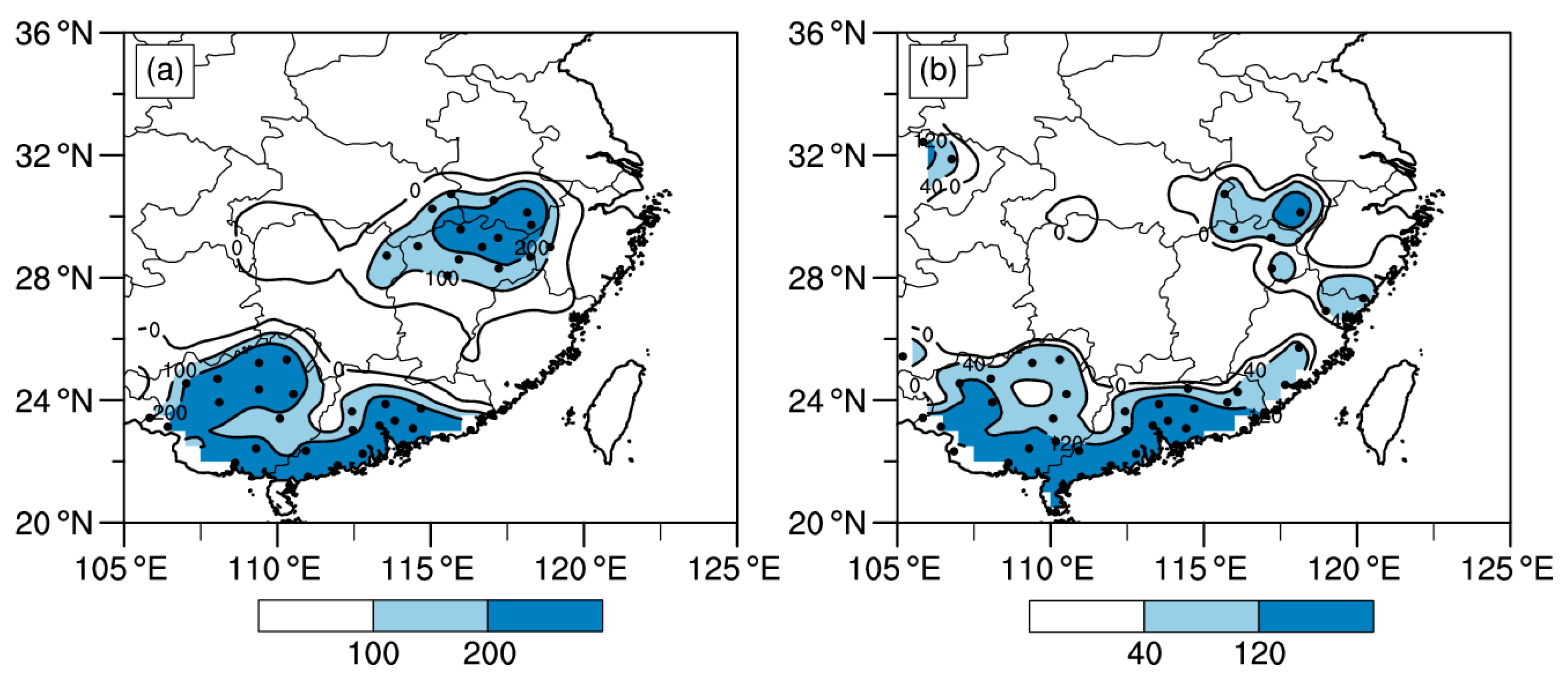
3.1. Comparison of the LF Characteristics of Summer Precipitation in Flood and Drought Years in Southern China
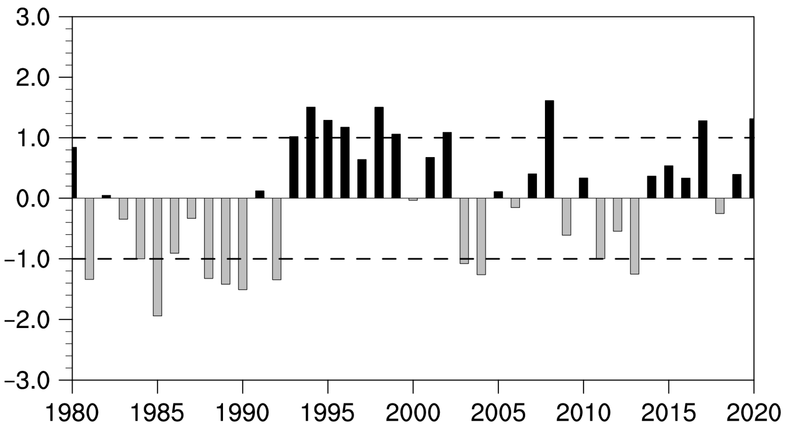
3.1.1. Selection of the Typical Flood and Drought Years
3.1.2. Selection of Representative Station
3.1.3. Comparison of LF Significant Periods of Precipitation in Flood and Drought Years
3.2. Comparison of LF Characteristics of Atmospheric Circulation Affecting LF Precipitation in Flood and Drought Years
3.2.1. OLR
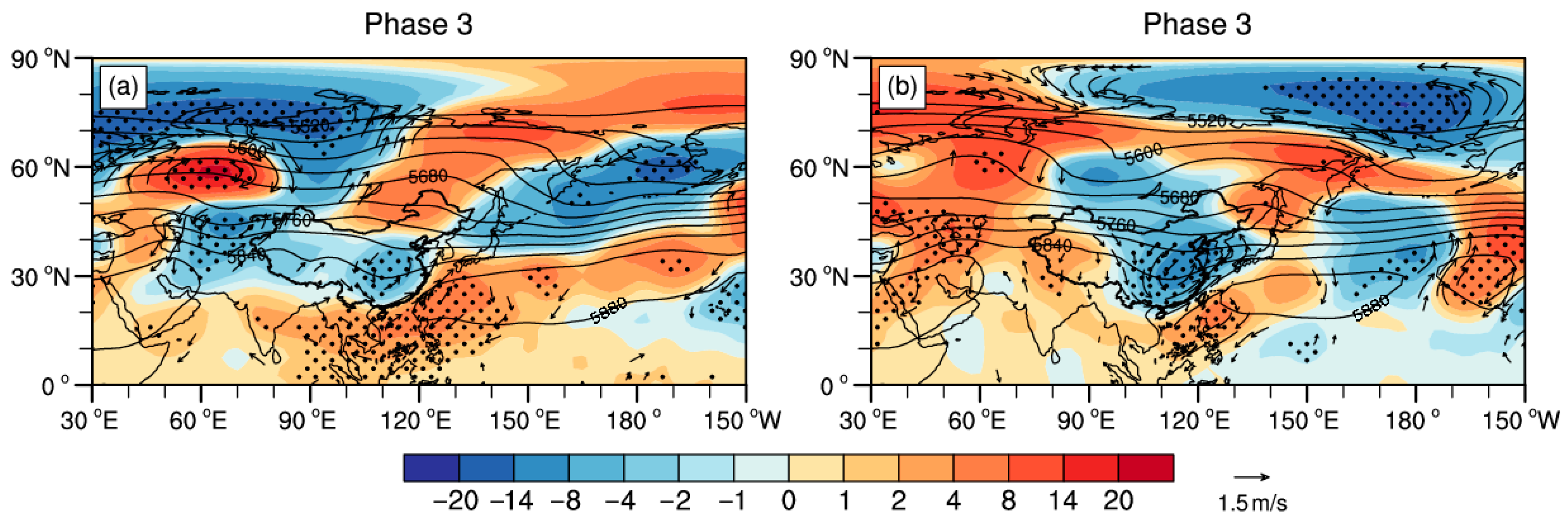
3.2.2. 500 hPa Height and Wind Field
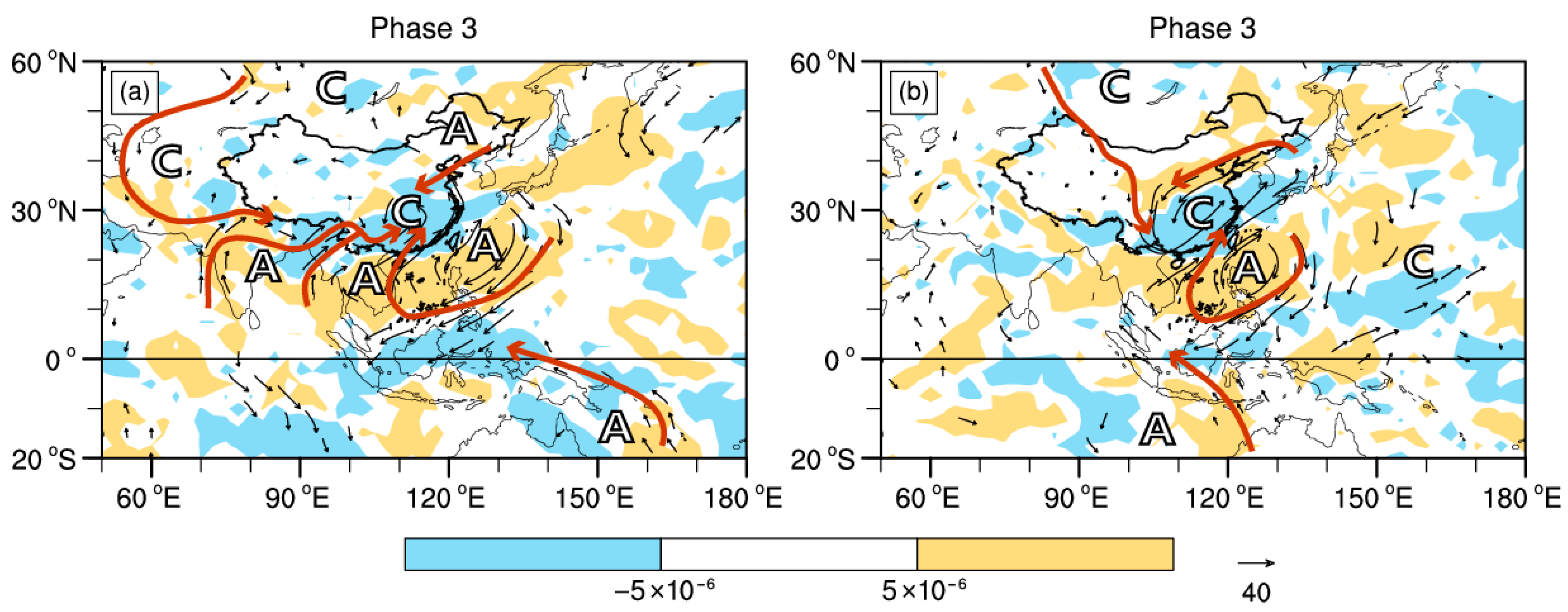
3.2.3. Column-Integrated Water Vapor Flux
3.3. Predictive Signals of LF Precipitation in Flood and Drought Years
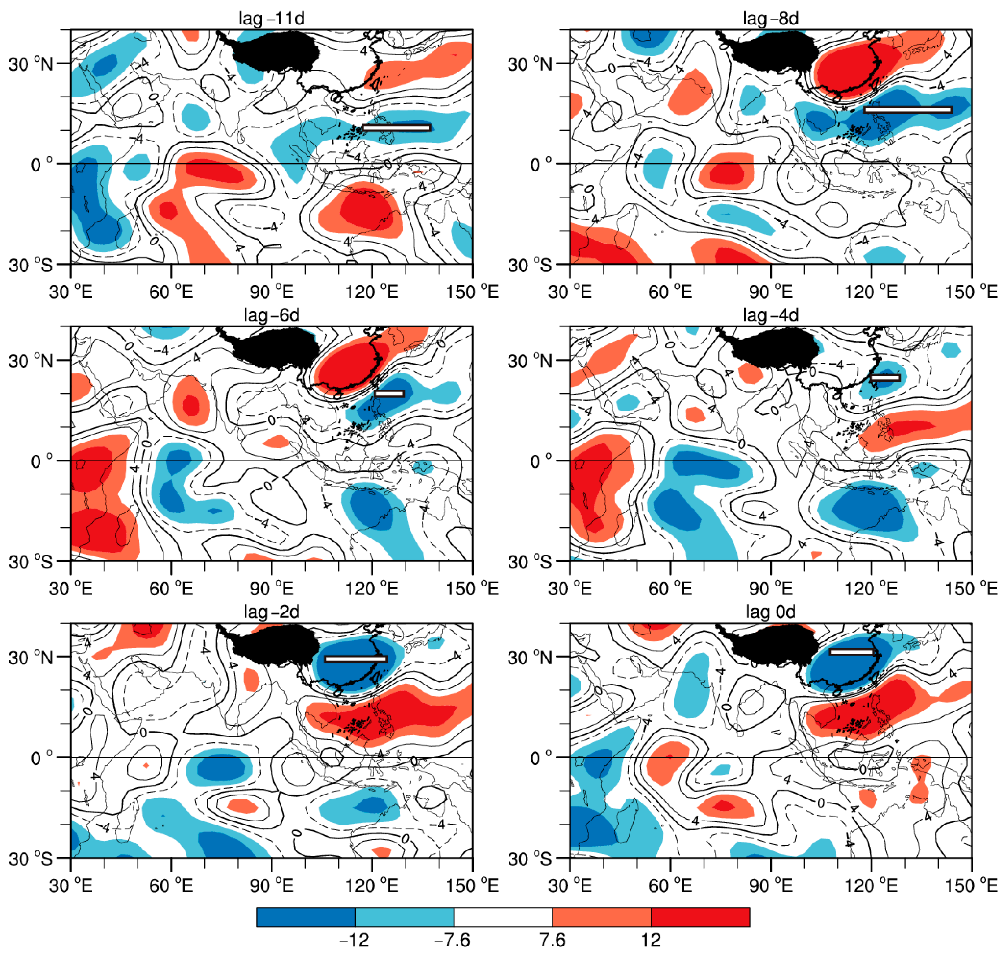
3.3.1. OLR
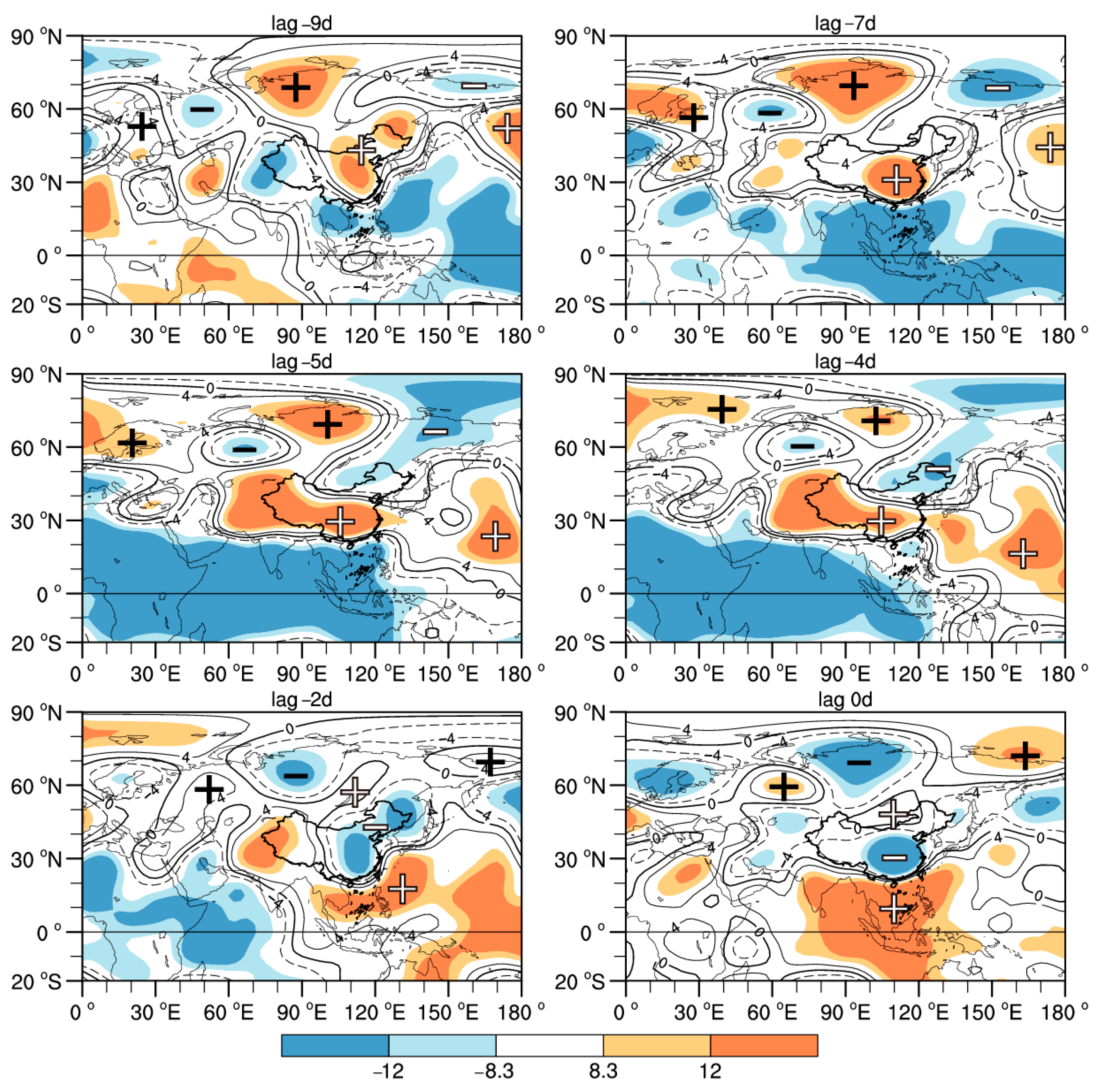
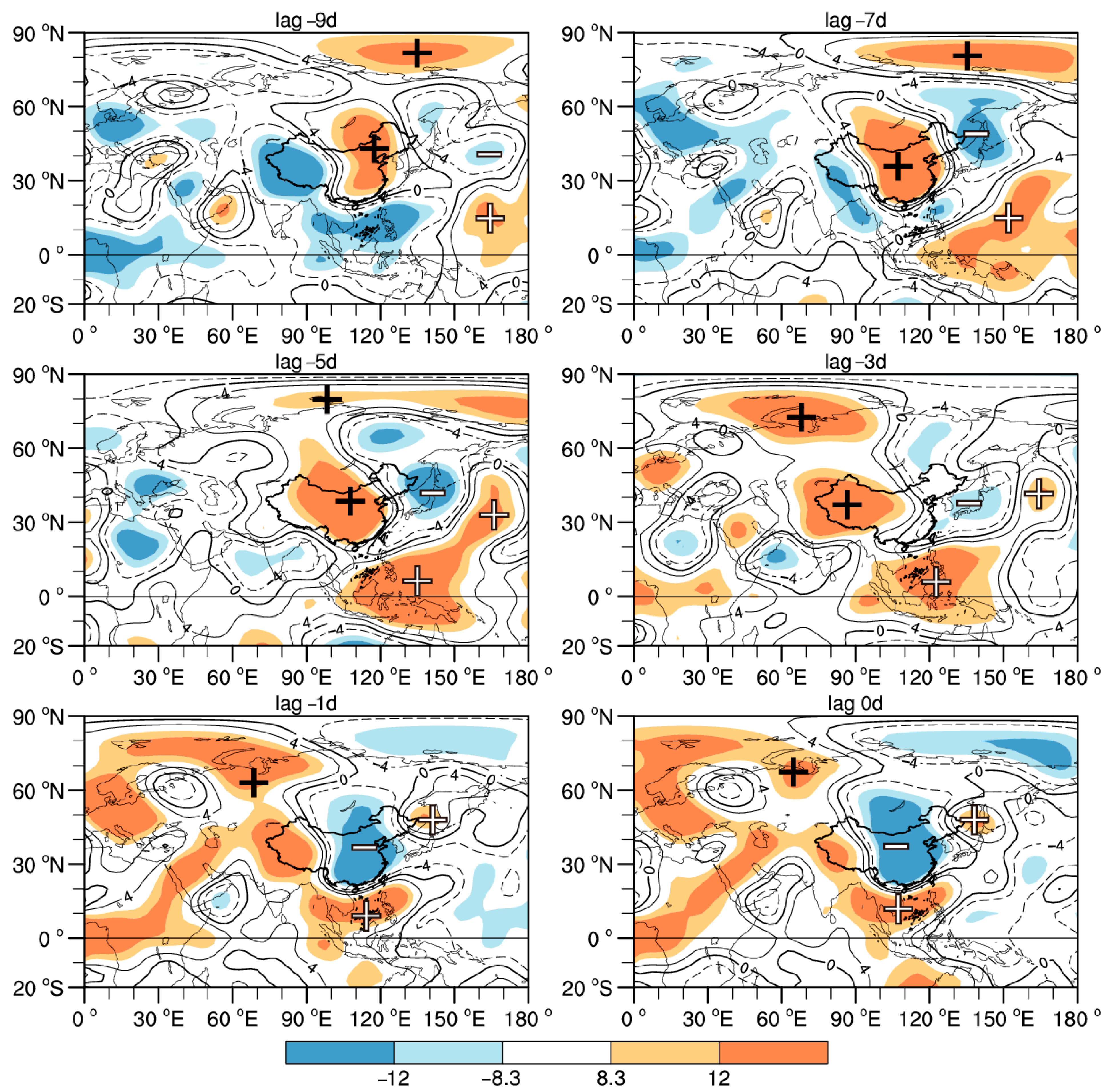
3.3.2. 500 hPa Height Field
4. Discussion and Conclusions
Author Contributions
Funding
Institutional Review Board Statement
Informed Consent Statement
Data Availability Statement
Acknowledgments
Conflicts of Interest
References
- Madden, R.A.; Julian, P.R. Detection of a 40–50 day oscillation in the zonal wind in the tropical Pacific. J. Atmos. Sci. 1971, 28, 702–708. [Google Scholar] [CrossRef]
- Madden, R.A.; Julian, P.R. Description of global-scale circulation cells in the tropics with a 40–50 day period. J. Atmos. Sci. 1972, 29, 1109–1123. [Google Scholar] [CrossRef]
- Li, C.Y. Low-Frequency Oscillation in the Atmosphere, Revised ed.; China Meteorological Press: Beijing, China, 1993. [Google Scholar]
- Ju, J.H.; Sun, D.; Lu, J.M. The influence of the east Asian monsoon stream on the large-scale precipitation course in eastern China. Chin. J. Atmos. Sci. 2007, 31, 1129–1139. [Google Scholar] [CrossRef]
- Dao, S.Y.; Hsu, S.Y. Some aspects of the circulation during the periods of the persistent drought and flood in Yantze and Hwai-Ho Valleys in summer. Acta Meteorol. Sin. 1962, 32, 1–10. [Google Scholar] [CrossRef]
- Li, W.J.; Zuo, J.Q.; Song, Y.L.; Liu, J.P.; Li, Y.; Shen, Y.S.; Li, J.X. Changes in spatio temporal distribution of drought/flood disaster in southern China under global climate warming. Meteorol. Mon. 2015, 41, 261–271. [Google Scholar] [CrossRef]
- Shi, J.; Cui, L.; Tian, Z. Spatial and temporal distribution and trend in flood and drought disasters in East China. Environ. Res. 2020, 185, 109406. [Google Scholar] [CrossRef]
- Ren, R.C.; Liu, Y.M.; Wu, G.X. Impact of South Asia high on the short-term variation of the subtropical anticyclone over western Pacific in July 1998. Acta Meteorol. Sin. 2007, 65, 183–197. [Google Scholar] [CrossRef]
- Lu, R.Y.; Ding, H.; Ryu, C.S.; Lin, Z.D.; Dong, H.L. Midlatitude westward propagating disturbances preceding intraseasonal oscillations of convection over the subtropical western North Pacific during summer. Geophys. Res. Lett. 2007, 34, e2007GL031277. [Google Scholar] [CrossRef]
- Bueh, C.; Shi, N.; Ji, L.R.; Wei, J.; Tao, S.Y. The mid-term evolution characteristics of EAP events in Meiyu period and Rossby wave activity in mid-high latitudes. Chin. Sci. Bull. 2008, 53, 111–121. [Google Scholar] [CrossRef]
- Ren, X.J.; Yang, D.J.; Yang, X.Q. Characteristics and mechanisms of the subseasonal eastward extension of the South Asian high. J. Clim. 2015, 28, 6799–6822. [Google Scholar] [CrossRef]
- Liu, F.; Ouyang, Y.; Wang, B.; Yang, J.; Ling, J.; Hsu, P.C. Seasonal evolution of the intraseasonal variability of China summer precipitation. Clim. Dyn. 2020, 54, 4641–4655. [Google Scholar] [CrossRef]
- Lau, K.M.; Yang, G.J.; Shen, S.H. Seasonal and intraseasonal climatology of summer monsoon rainfall over East Asia. Mon. Weather Rev. 1988, 116, 18–37. [Google Scholar] [CrossRef]
- Yang, H.; Li, C.Y. The relation between atmospheric intraseasonal oscillation and summer severe flood and drought in the Changjiang—Huaihe River Basin. Adv. Atmos. Sci. 2003, 20, 540–553. [Google Scholar] [CrossRef]
- Mao, J.Y.; Wu, G.X. Intraseasonal variability in the Yangtze-Huaihe River rainfall and subtropical high during the 1991 Meiyu period. Acta Meteorol. Sin. 2005, 63, 762–770. [Google Scholar] [CrossRef]
- Chen, D.P.; Guan, Z.Y.; Hou, J.; Xi, Z.H. The 10–30-day intraseasonal oscillations of circulations and their associations with Rossby wave packets in the upper troposphere during persistent severe rainfall in summer 2007. Trans. Atmos. Sci. 2016, 39, 177–188. [Google Scholar] [CrossRef]
- Ju, J.H.; Qian, C.; Cao, J. The intraseasonal oscillation of East Asian summer monsoon. Chin. J. Atmos. Sci. 2005, 29, 187–194. [Google Scholar] [CrossRef]
- Chen, J.P.; Wen, Z.P.; Wu, R.G.; Chen, Z.S.; Zhao, P. Influences of northward propagating 25–90-day and quasi-biweekly oscillations on eastern China summer rainfall. Clim. Dyn. 2015, 45, 105–124. [Google Scholar] [CrossRef]
- Shen, Y.Y.; Ren, H.L.; Li, W.J.; Zhang, Y.J.; Zuo, J.Q. Relationship between summer low-frequency rainfall over southern China and propagation of tropical intraseasonal oscillation. J. Trop. Meteorol. 2016, 24, 31–34. [Google Scholar] [CrossRef]
- Ren, X.J.; Fang, J.B.; Yang, X.Q. Characteristics of intra-seasonal oscillation of summer precipitation in eastern China and its related low frequency atmospheric circulation. J. Meteorol. Sci. 2020, 40, 686–696. [Google Scholar] [CrossRef]
- Chen, G.J.; Wei, F.Y. An Extended-Range Forecast method for the persistent heavy rainfall over the Yangtze-Huaihe River Valley in summer based on the Low-Frequency Oscillation characteristics. Chin. J. Atmos. Sci. 2012, 36, 633–644. [Google Scholar] [CrossRef]
- Zhou, N.F.; Li, Y.; Jia, X.L. Relationship between heavy precipitation and atmospheric wave with different time scales during Meiyu period in Yangtze-Huai River region. J. Trop. Meteorol. 2021, 37, 14–24. [Google Scholar] [CrossRef]
- Min, J.Z.; Li, C.; Wu, P. A Study of the relationship between summer tropical convection over the western pacific and the rainfall in the middle-lower reaches of the Yangtze River. Chin. J. Atmos. Sci. 2005, 29, 947–954. [Google Scholar] [CrossRef]
- Yang, J.; Wang, B.; Wang, B.; Bao, Q. Biweekly and 21–30-day variations of the subtropical summer monsoon rainfall over the lower reach of the Yangtze River basin. J. Clim. 2010, 23, 1146–1159. [Google Scholar] [CrossRef]
- Liang, P.; Ding, Y.H. Climatologic characteristics of the intraseasonal oscillation of East Asian meiyu. Acta Meteorol. Sin. 2012, 70, 418–435. [Google Scholar] [CrossRef]
- Feng, H.S.; Zhai, P.M. Low-frequency oscillation and SST variations of regional persistent extreme precipitation in East China. J. Trop. Meteorol. 2016, 2, 385–398. [Google Scholar] [CrossRef]
- Li, L.P.; Bai, T. Low-frequency characteristic of multi-year mean summer precipitation in South China and its relationships with low-frequency water vapor transport. Trans. Atmos. Sci. 2014, 37, 323–332. [Google Scholar] [CrossRef]
- Kong, X.Y.; Mao, J.Y.; Wu, G.X. Influence on the South China rainfall anomalies of the atmospheric quasi-biweekly oscillation in mid-high latitude during the summer of 2002. Chin. J. Atmos. Sci. 2017, 41, 1204–1220. [Google Scholar] [CrossRef]
- Xin, F.; Xiao, Z.N.; Li, Z.C. Relation between flood season precipitation anomalies in South China and East Asian atmospheric low frequency oscillation in 1997. Meteorol. Mon. 2007, 33, 23–30. [Google Scholar] [CrossRef]
- Miao, R.; Wen, M.; Zhang, R.H. Persistent precipitation anomalies and quasi-biweekly oscillation during the annually first rainy season over South China in 2010. J. Trop. Meteorol. 2017, 33, 155–166. [Google Scholar] [CrossRef]
- Huang, Y.; Xiao, T.G.; Jin, R.H. Effects of Low-frequency Oscillation on the Persistent Extreme Precipitation in Sichuan Basin. J. Appl. Meteorol. Sci. 2019, 30, 93–104. [Google Scholar] [CrossRef]
- Bai, H.; Xiang, B.; Wu, Z.P.; Luo, Y.H. Extended-range forecast of the regional heavy rainfall process in Guizhou by studying MJO activity trajectory. J. Meteorol. Sci. 2022, 42, 193–203. [Google Scholar] [CrossRef]
- Wang, Z.Y.; Ding, Y.H. Climatic features of intraseasonal oscillations of summer rainfalls over mid-lower reaches of the Yangtze River in the flood and drought years. J. Appl. Meteorol. Sci. 2008, 19, 710–715. [Google Scholar] [CrossRef]
- Tong, J.; Xu, H.M.; Zhi, H. Characteristics of low frequency oscillation of precipitation and convection in drought/flood and drought-flood-coexistence years over the Yangtze-Huaihe basin. Trans. Atmos. Sci. 2013, 36, 409–416. [Google Scholar] [CrossRef]
- Li, Y.H.; Xu, H.M.; Gao, Y.H.; Li, Q.; Bai, Y.Y.; He, Z.N. Characteristics of Outgoing Longwave Radiation Related to Typical Flood and Drought Years over the East of Southwest China in Summer. Plateau Meteorol. 2009, 28, 861–869. [Google Scholar]
- Li, L.P.; Ma, C.Y.; Yang, C.Y. Study on the differences in water vapour characteristics and predictive signals of low-frequency precipitation in the pre-flood season of South China between flood and drought years. Int. J. Climatol. 2020, 40, 6587–6602. [Google Scholar] [CrossRef]
- Kalnay, E.; Kanamitsu, M.; Kistler, R.; Collins, W.; Deaven, D.; Gandin, L.; Joseph, D.; Iredell, M.; Saha, S.; White, G.; et al. The NCEP/NCAR 40-year reanalysis project. Bull. Am. Meteorol. Soc. 1996, 77, 437–472. [Google Scholar] [CrossRef]
- Hersbach, H.; Bell, B.; Berrisford, P.; Hirahara, S.; Horányi, A.; Muñoz-Sabater, J.; Nicolas, J.; Peubey, C.; Radu, R.; Schepers, D.; et al. The ERA5 global reanalysis. Q. J. R. Meteorol. Soc. 2020, 146, 1999–2049. [Google Scholar] [CrossRef]
- Liebmann, B.; Smith, C.A. Description of a complete (interpolated) outgoing longwave radiation dataset. Bull. Am. Meteorol. Soc. 1996, 77, 1275–1277. Available online: http://www.jstor.org/stable/26233278 (accessed on 16 May 2022).
- Zhi, X.F.; Zhang, L.; Pan, J.L. An analysis of the winter extreme precipitation events on the background of southern China climate warming. J. Trop. Meteorol. 2011, 27, 166–172. [Google Scholar] [CrossRef]
- Fu, Y.X.; Bueh, C. Wintertime extensive and persistent low-temperature events of China and anomalous precipitation over southern China. Chin. J. Atmos. Sci. 2013, 37, 166–172. Available online: http://www.dqkxqk.ac.cn/dqkx/dqkx/article/abstract/20130608 (accessed on 16 May 2022).
- Wang, H.J. The weakening of the Asian monsoon circulation after the end of 1970’s. Adv. Atmos. Sci. 2001, 18, 376–386. [Google Scholar] [CrossRef]
- Ding, Y.H.; Wang, Z.Y.; Sun, Y. Inter-decadal variation of the summer precipitation in East China and its association with decreasing Asian summer monsoon. Part I: Observed evidences. Int. J. Climatol. 2008, 28, 1139–1161. [Google Scholar] [CrossRef]
- Wu, H.B.; Wu, L. Diagnosis and Prediction Method of Climate Variability; China Meteorological Press: Beijing, China, 2005. [Google Scholar]
- Wang, R.; Wang, P.X.; Wu, H.B.; Li, L.P.; Chen, Y.C.; Liu, Q.Q. A simple scheme of Monte Carlo significance test for wavelet power spectrum. J. Nanjing Inst. Meteorol. 2009, 32, 140–144. [Google Scholar] [CrossRef]
- Murakami, M. Analysis of deep convective activity over the western Pacific and Southeast Asia. Part II: Seasonal and intraseasonal variation during the northern summer. J. Meteorol. Soc. Jpn. 1984, 62, 88–108. [Google Scholar] [CrossRef][Green Version]
- Maloney, E.D.; Hartmann, D.L. Frictional Moisture Convergence in a Composite Life Cycle of the Madden-Julian Oscillation. J. Clim. 1998, 11, 2387–2403. [Google Scholar] [CrossRef]
- Mao, J.Y.; Chan, J.C.L. Intraseasonal variability of the South China Sea summer monsoon. J. Clim. 2005, 18, 2388–2402. [Google Scholar] [CrossRef]
- Huang, J.Y. Meteorological Statistical Analysis and Forecasting Method; China Meteorological Press: Beijing, China, 2004. [Google Scholar]
- Yanai, M.; Li, C.F.; Song, Z.S. Seasonal heating of the Tibetan Plateau and its effects on the evolution of the Asian summer monsoon. J. Meteorol. Soc. Jpn. Ser. II 1992, 70, 319–351. [Google Scholar] [CrossRef]
- Wei, F.Y. Modern Climate Statistical Diagnosis and Prediction Techniques; China Meteorological Press: Beijing, China, 2007. [Google Scholar]
- Davis, R.E. Predictability of sea surface temperature and sea level pressure anomalies over the North Pacific Ocean. J. Phys. Oceanogr. 1976, 6, 249–266. [Google Scholar] [CrossRef]
- Chen, W.Y. Fluctuations in Northern Hemisphere 700 mb height field associated with the Southern Oscillation. Mon. Weather Rev. 1982, 110, 808–823. [Google Scholar] [CrossRef]
- Shi, N. Multivariate Analysis Methods in Meteorological Research and Forecasting, 2nd ed.; China Meteorological Press: Beijing, China, 2002. [Google Scholar]
- Wu, R.W.; Wen, Z.P.; Yang, S.; Li, Y.Q. An interdecadal change in southern China summer rainfall around 1992/93. J. Clim. 2010, 23, 2389–2403. [Google Scholar] [CrossRef]
- Xu, Z.Q.; Fan, K.; Wang, H.J. Decadal variation of summer precipitation over China and associated atmospheric circulation after the late 1990s. J. Clim. 2015, 28, 4086–4106. [Google Scholar] [CrossRef]
- Li, L.P.; Xu, G.Y.; Liu, Y.J. Influence of low-frequency moisture transportation on low-frequency precipitation anomalies in the annually first rain season of South China in 2010. J. Trop. Meteorol. 2014, 30, 423–431. [Google Scholar] [CrossRef]
- Wang, Q.Y.; Ding, Y.H. The distribution of the apparent heat source and apparent moisture sink over East Asia and the Pacific Ocean in 1982. Clim. Environ. Res. 1996, 1, 65–77. [Google Scholar] [CrossRef]
- Wang, L.J.; Wen, M.; Luo, L.; He, J.H.; Lin, J. The relationship between the position variation of the West Pacific Subtropical High and the apparent heating. J. Trop. Meteorol. 2005, 21, 488–496. [Google Scholar] [CrossRef]
- Wang, L.J.; Pang, Y.; Yu, B.; Li, Y.J. The characteristics of persistent heavy rain events and 10–30 day low-frequency circulation in Yangtze-Huaihe River Basin during Meiyu period. J. Trop. Meteorol. 2014, 30, 851–860. [Google Scholar] [CrossRef]
- Ding, Y.H.; Wu, X.X.; Ma, S.F. A study of the surface fluxes and structure of mixed layer during the Meiyu rainfall over the Yangtze Huaihe River basin in 1991. Acta Meteorol. Sin. 1997, 55, 2–15. [Google Scholar] [CrossRef]
- Gill, A.E. Some simple solutions for heat-induced tropical circulation. Q. J. R. Meteorol. Soc. 1980, 106, 447–462. [Google Scholar] [CrossRef]
- Wang, L.J.; Guan, Z.Y.; He, J.H. The circulation background of the extremely heavy rain causing severe floods in Huaihe river valley in 2003 and its relationships to the apparent heating. J. Meteorol. Sci. 2008, 28, 1–7. [Google Scholar] [CrossRef]
- Zhu, Q.G.; Lin, J.R.; Shou, S.W.; Tang, D.S. Principles and Methods of Weather Science, 4th ed.; China Meteorological Press: Beijing, China, 2007. [Google Scholar]
- Zhang, T.; Wei, F.Y. Largescale circulation background of heavy rainfall processes over South China from May to June, 2008. J. Trop. Meteorol. 2010, 26, 633–640. [Google Scholar] [CrossRef]


| Flood Years | Drought Years | ||||
|---|---|---|---|---|---|
| Year | LF Period (d) | The Dates of Phase 3 (Number: 35) | Year | LF Period (d) | The Dates of Phase 3 (Number: 36) |
| 1993 | 10–20 | 18 June, 30 June, 20 July | 1981 | 10–20, 30–60 | 11 June, 29 June, 11 July, 24 July, 11 August |
| 1994 | 10–20, 30–60 | 9 June, 25 June, 5 July, 6 August | 1985 | 10–20 | 25 June, 5 July, 12 August |
| 1995 | 10–20 | 24 July, 3 August | 1988 | 10–20, 30–60 | 28 June, 12 July, 28 July, 8 August |
| 1996 | 10–20, 20–30 | 2 July, 15 July, 2 August, 17 August | 1989 | 10–20 | 17 June, 30 June, 11 July, 26 July |
| 1998 | 10–20 | 23 June, 3 July, 23 July | 1990 | 10–20, 20–30 | 17 June, 1 July, 14 July, 1 August, 21 August |
| 1999 | 10–20 | 8 June, 24 June, 16 July, 13 August | 1992 | 10–20 | 5 July, 22 July |
| 2002 | 10–20, 20–30 | 11 June, 21 July, 7 August | 2003 | 10–20, 20–30 | 10 June, 25 June, 9 July, 24 July |
| 2008 | 10–20, 20–30 | 13 June, 27 June, 8 July, 21 July, 15 August | 2004 | 10–20, 60–90 | 24 June, 6 July, 19 July, 31 July, 14 August |
| 2017 | 10–20 | 14 June, 18 July, 1 August, 3 August | 2013 | 10–20 | 8 June, 25 June, 19 July, 2 August |
| 2020 | 10–20, 60–90 | 8 July, 19 July, 5 August | |||
| Flood Years | Drought Years | |
|---|---|---|
| southern boundary | 89.7 | 92.7 |
| northern boundary | −14.9 | 33.5 |
| western boundary | 21.1 | 23.4 |
| eastern boundary | −32.0 | −87.5 |
| net budget | 63.9 | 62.1 |
| water vapor channel (number) | the northerly and then westerly dry-cold, the northeasterly cold-wet, and the southwesterly and the southeasterly warm-wet channels (4) | the central westerly dry-cold, the northeasterly cold-wet, and the southeasterly warm-wet channels (3) |
| Flood Years | Drought Years | ||
|---|---|---|---|
| OLR | convective source (−11 d) | Somalia | the south of the Indochina Peninsula |
| moving direction | northeast | north | |
| WPSH | source (−9 d) | the northeastern and eastern China; the Bering Sea | the northeastern New Guinea |
| moving direction | south; southwest | west | |
| the East Asian Trough | source (−9 d) | the East Siberia | the Sea of Okhotsk and the northwestern Pacific |
| moving direction | southwest | west | |
Publisher’s Note: MDPI stays neutral with regard to jurisdictional claims in published maps and institutional affiliations. |
© 2022 by the authors. Licensee MDPI, Basel, Switzerland. This article is an open access article distributed under the terms and conditions of the Creative Commons Attribution (CC BY) license (https://creativecommons.org/licenses/by/4.0/).
Share and Cite
Liu, L.; Li, L.; Zhu, G. Effects of Low-Frequency Oscillation at Different Latitudes on Summer Precipitation in Flood and Drought Years in Southern China. Atmosphere 2022, 13, 1277. https://doi.org/10.3390/atmos13081277
Liu L, Li L, Zhu G. Effects of Low-Frequency Oscillation at Different Latitudes on Summer Precipitation in Flood and Drought Years in Southern China. Atmosphere. 2022; 13(8):1277. https://doi.org/10.3390/atmos13081277
Chicago/Turabian StyleLiu, Lu, Liping Li, and Guanhua Zhu. 2022. "Effects of Low-Frequency Oscillation at Different Latitudes on Summer Precipitation in Flood and Drought Years in Southern China" Atmosphere 13, no. 8: 1277. https://doi.org/10.3390/atmos13081277
APA StyleLiu, L., Li, L., & Zhu, G. (2022). Effects of Low-Frequency Oscillation at Different Latitudes on Summer Precipitation in Flood and Drought Years in Southern China. Atmosphere, 13(8), 1277. https://doi.org/10.3390/atmos13081277