Abstract
The mechanism for convection initiation (CI) associated with the merger of an immature sea-breeze front (SBF) and gust front (GF) that occurred in North China on 31 July 2010 was investigated based on both observations and Weather Research and Forecasting (WRF) model simulation. The results show that many CIs occurred continuously in the merging area, and eventually resulted in an intense mesoscale convective system (MCS). The WRF simulation captured the general features of the SBF, GF, their merger processes and associated CIs, as well as the resulting MCS. Quantitative Lagrangian vertical momentum budgets, in which the vertical acceleration was decomposed into dynamic and buoyant components, were conducted along the backward trajectories of air parcels within a convective cell initiated in the merger processes. It was found that both of the dynamic and buoyant accelerations played important roles for the CI. The buoyant acceleration was dominated by the warming due to the latent heat release within the convective cell. Further decomposition of the dynamic acceleration showed the vertical twisting and extension contributed significantly to the dynamic acceleration, while the horizontal curvature was rather small. The vertical twisting was generated due to the vertical shear of horizontal wind, while the extension indicated convergences owing to a mid-level blocking convergence effect and squeezing, and (or) merging of the convergent leading edges of both fronts during their merger processes. The weak convergent leading edge of the immature SBF played an important role for the formation of the convergences.
1. Introduction
Severe convective storms pose many serious threats to lives, properties, and economy via torrential rain, lightning, large hail, severe winds, and tornadoes. Although much progress has been made in understanding the structure and life cycle of severe convective storms, the accurate prediction of convection initiation (CI) remains one of the biggest challenges in meteorology [1,2,3,4,5,6].
CI has been referred to as the process that air parcels ascend to their level of free convection (LFC), maintain positive buoyancy over a significant upward displacement, and finally initiate a deep convective cloud [7]. Lock and Houston [1] studied over 55,000 CI cases and concluded that there were four primary factors controlling the occurrence of CI, that is, buoyancy, inhibition, dilution, and lift. They stated that lift appeared to be the most often factor that helped distinguish the CI environment. Similarly, Markowski [7] also mentioned that lift played a decisive role for CI, including the lift by convergent boundary zones (CBZs) such as dry lines, lake-breeze front, horizontal convective rolls (HCRs), sea-breeze fronts (SBFs), and gust fronts (GFs).
GFs and SBFs are perhaps the most common CBZs that induce CI in the coastal area. GFs are the leading edge of cold pool outflows produced by mesoscale convective systems (MCSs), which are usually accompanied by a surge of gusty winds on or near the ground. The lift induced by the convergence at the leading edge of the GFs can often cause CI [8,9,10,11,12,13,14,15]. SBFs are defined as the leading edge of sea breeze circulation which are driven directly by the land-sea thermal contrast and flow inland at the coastline on fine days [16]. It is sometimes characterized by rapid variation of wind speed and (or) wind direction, temperature, and moisture, resembling a minor cold front. Similarly, CI can also occur near the leading edge of SBFs due to the updraft generated by the convergence at the leading edge of the SBFs [17,18,19,20]. Bergemann et al. [21] found that SBFs play a crucial role in the formation of precipitation over the Mediterranean and Maritime Continent, and 40–60% of the total rainfall can be related to SBFs.
The basic typical structures or circulations of a mature sea-breeze circulation are considered as rear-to-front feeder flow in the mid-lower level of the sea-breeze current (SBC), SBF head at the leading edge of the SBC, significant convergent updraft at the leading edge of the SBF, Kelvin–Helmholtz Billows (KHBs) (KHBs defined as streamwise vortex structures arising in the strongly sheared braids between adjacent billows or within the billow cores at the interface between fluids of differing densities [22,23,24,25]), behind the head of the SBF, front-to-rear return flow above the KHBs, and vertical rotor circulations (i.e., closed vertical circulation) following closely to the leading edge of the SBF [16,26,27,28,29,30]. If some of these structures or circulations are not yet formed in a sea-breeze circulation, the SBF is considered as an immature SBF. Therefore, the immaturity of the SBF can be quantitatively defined as the absence of one or more aforementioned structures or circulations in the sea-breeze circulation.
CI or storm development often occurs when two or more CBZs merge or collide. For example, 73% of the storms over the southeastern United States were caused by the mergers of CBZs [31]. Similarly, 71% of 418 storms observed by Wilson and Schreiber [9] were attributed to merging convergence zones. Mergers of GFs and SBFs have drawn attention due to their high efficiency in CI, storm development, precipitation enhancement, generation of atmospheric bores. Nicholls et al. [32] mentioned that deep convection could develop in their Florida simulations between the east and west coast SBFs as they merge together. Similarly, Fankhauser et al. [33] examined a GF–SBF interaction and demonstrated that CI occurred in the air mass between the two features, as they came close and eventually merged. Kingsmill and Crook [34] investigated ten cases involving collisions between GFs and SBFs over Florida, and found that 71% of the observed post-collision boundaries initiated new convection or enhanced existing convection, and the after-collision boundaries exhibited bore and solitary wave characteristics. Wu and Lombardo [20] studied a mechanism for precipitation enhancement in squall lines moving over mountainous coastal regions, and found that storms are most intense as they encounter the deepest SBFs. Consequently, GFs and SBFs are of great importance in the study of nowcasting and short-range forecasting as well as in convective storm dynamics [20,32,33,34,35,36,37,38].
However, the CI mechanisms associated with the merger of SBFs and GFs are complicated, and a better understanding of this kind of CI is still needed. Especially, to the authors’ knowledge, there was no previous study reporting the CI mechanism associated with the merger of an immature SBF and a GF. This study aimed to investigate the mechanism of CIs which occurred repeatedly during the merger of an immature SBF and a GF in the Bohai Bay Region, North China, on 31 July 2010.
The remaining parts of this paper are organized as follows. Section 2 provides a brief overview of the immature SBF, GF, and their merger process, as well as the associated CIs in the region. Section 3 presents the numerical simulation setup and model evaluation. The mechanism of CI associated with the merger of the immature SBF and GF is analyzed in detail in Section 4. Finally, a summary and discussion are given in Section 5.
2. Case Overview
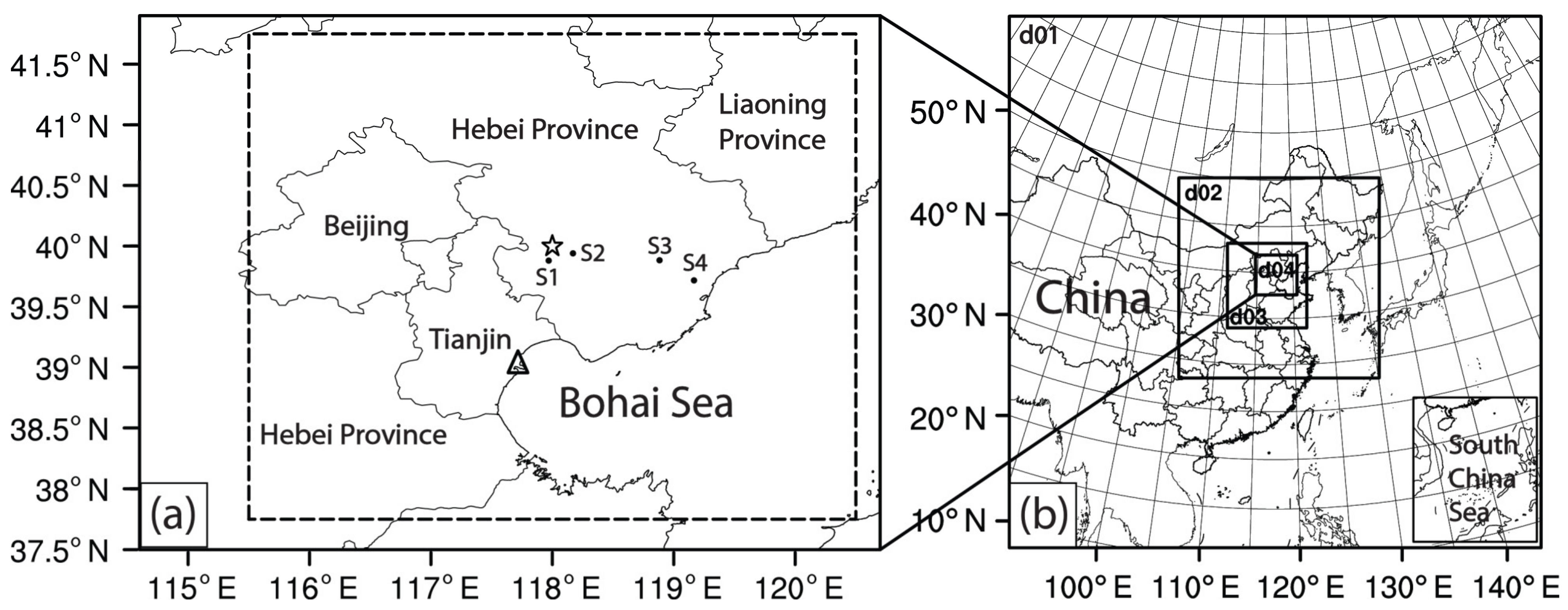
A severe convective storm occurred in the Beijing-Tianjin-Hebei area in North China (Figure 1) from 0000 to 1000 UTC on 31 July 2010. It mainly caused short-time heavy rainfall (up to 48 mm h−1) and lightning. Moreover, more than 1100 hectare of crops were damaged. The main precipitation took place over southeastern Hebei Province and Tianjin during 0200–0800 UTC.

Figure 1.
(a) Study area where the severe convective storm occurred. The black dots indicate the locations of the ground-based automatic stations (S1, S2, S3, and S4) that will be mentioned in Figure 4. The dashed rectangle area denotes the area analyzed in Figures 3, 7 and 8. The black triangle symbol represents the location (39.044° N, 117.717° E) of Tianjin weather radar that will be shown in the following part of the paper. The black asterisk symbol represents the grid point location (40° N, 118° E) of National Centers for Environmental Prediction (NCEP) Final (FNL) reanalysis data soundings that will be shown in Figure 6. (b) Geographic locations of the WRF model domains. The innermost domain (d04, i.e., the domain No.4) covers the whole area shown in (a).
2.1. System Evolution
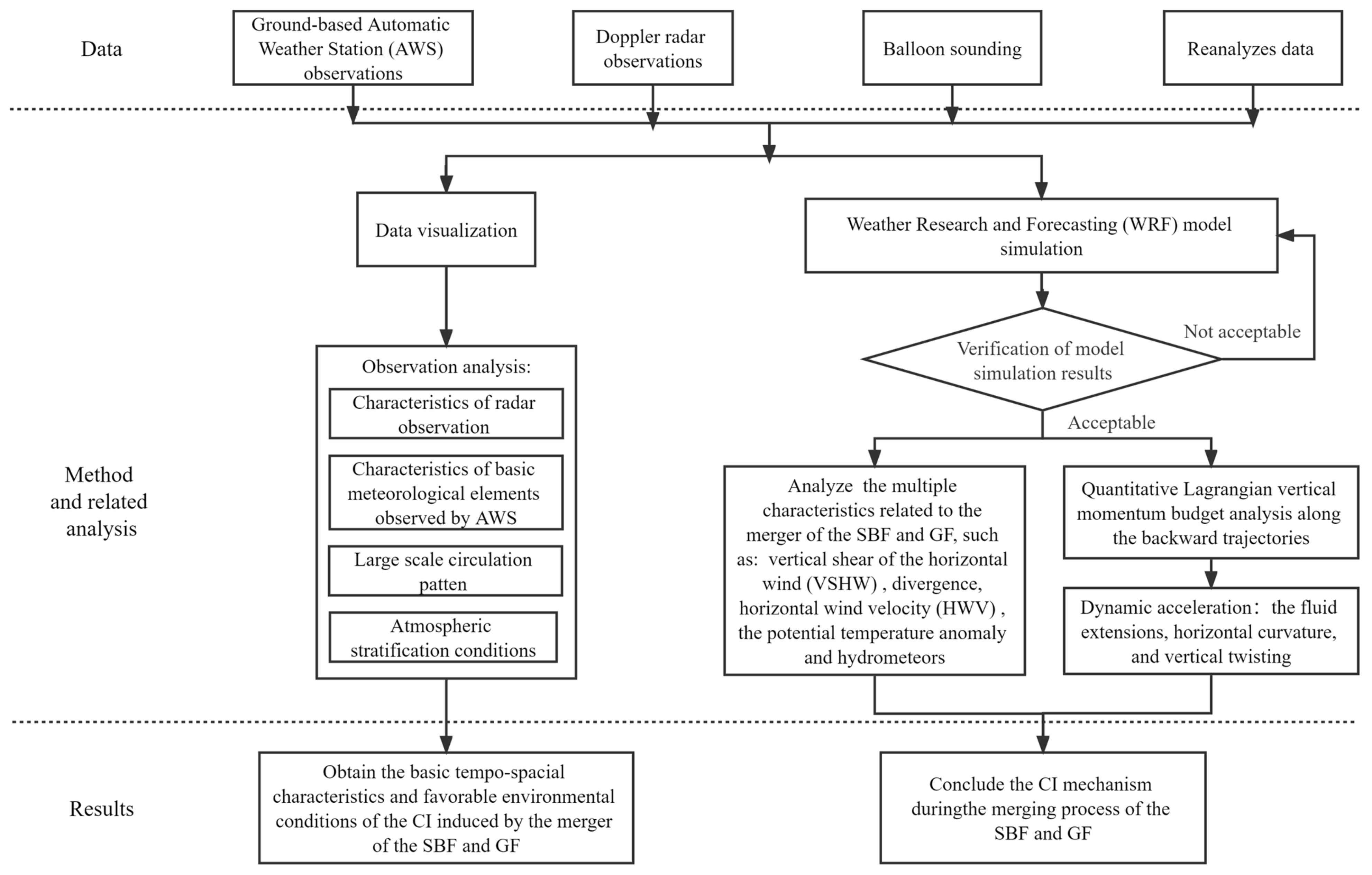
The dataset utilized in the present study includes conventional observational data from Doppler radar, ground-based automatic stations (with a temporal resolution of 1 h), and balloon sounding. All these observation data were provided by the National Meteorological Center of the China Meteorological Administration (Tianjin). The methodology used in this study is shown in a flowchart in Figure 2.

Figure 2.
Flowchart of research approach and structure of present study.
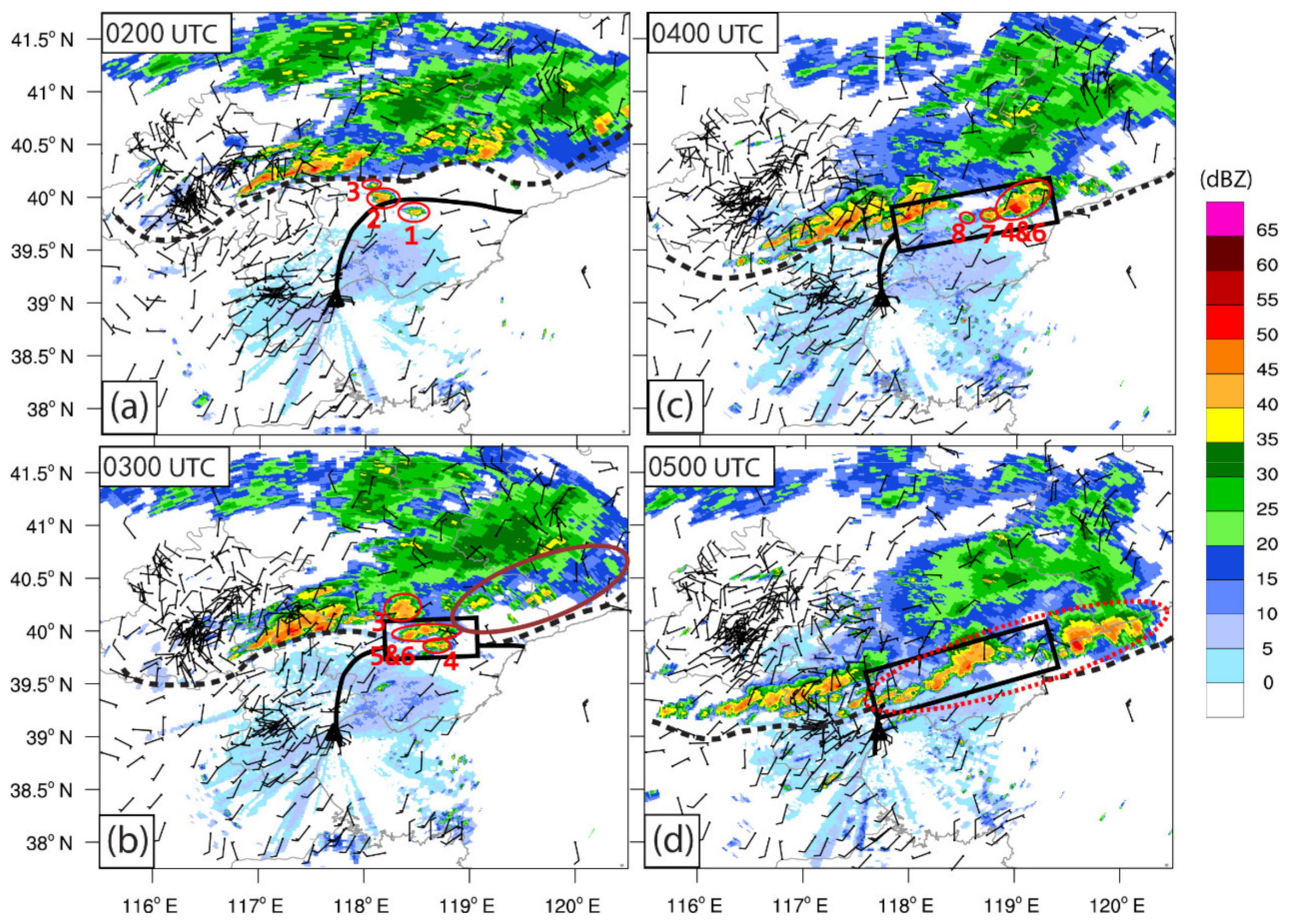
The evolution of the severe convective storm, associated GF and SBF, were observed by the Tianjin Doppler radar (Tianjin) and ground-based automatic weather stations. There was a mesoscale convective system (MCS) over Beijing and northeastern Hebei at 0000 UTC on July 31 (figure not shown). At 0200 UTC (Figure 3a), the MCS further moved south-southeastward, along with a GF (indicated by the black dotted line) at about 10–30 km to the south of the MCS. Meanwhile, a slow-moving immature SBF (denoted by black solid line) from Bohai Sea can be identified in the eastern Tianjin and southeastern Hebei Province, while the GF was moving at a relatively faster speed. The immaturity of the SBF was mainly exhibited in its northeastern half part, showing a quite weak and quasi-stationary state.

Figure 3.
(a–d) Composite radar reflectivity (shading, units: dBZ) observed by Tianjin radar station (indicated by black triangle) and wind fields (half barbs and full barbs represent 2 and 4 m s−1, respectively) observed by ground-based automatic weather stations on 31 July 2010. The black solid lines indicate the locations of the SBF, and black dashed lines denote the locations of the GF. The black rectangle area indicates the merging area. The locations of the convections initiated near the merging area are indicated by red ellipses or circles, and the numbers in red indicate the sequence number of the newly initiated convective cells. The solid brown ellipse shows the area where the convective system significantly weakened and (or) dissipated. The dotted red ellipse denotes the mesoscale convective system (MCS) initiated and (or) developed due to the merger of the GF and SBF. The specific time is shown in the upper left corner of each panel.
The CI is often defined once the composite reflectivity reaches 35 dBZ within a convection [15,37,39,40,41], which is also adopted in this work. As shown in Figure 3a, several CIs (shown in red ellipses, and labeled as CI1, CI2, and CI3) occurred near the central parts of both the SBF and GF, also considered as their closest part to each other. These convective cells developed gradually with time in both size and intensity. At 0300 UTC (Figure 3b), the GF merged with the northern part of the SBF over the southeastern Hebei, along with some other CIs which occurred in the area where they merged. Meanwhile, the convective system behind the eastern half part of the GF was significantly weakened and almost dissipated.
By 0400 UTC (Figure 3c), the GF had further moved southward, with the merging area becoming wider. Meanwhile, some previously initiated convective cells in the merging area further developed and began to move eastward. Moreover, several other CIs occurred (labeled as CI7 and CI8) in the merging area. In the following ~1 h (Figure 3d), previously initiated convections in the merging area further developed and further moved eastward. Meanwhile, more CIs took place in the merging area, and most of them underwent obvious development and merged together. Finally, they formed a large and intense quasi-linear MCS (i.e., squall line) which oriented in northeast-southwest direction. It shows almost the same orientation as that of the merging area. It is noteworthy that there was a new, relatively strong MCS behind the eastern part of the GF, where the convection had significantly dissipated around 0300 UTC. It was mainly due to the newly initiated and developed convections owing to the merger of the weak and immature quasi-stationary northern part of the SBF and GF. These newly generated convective systems due to the merger processes were mainly responsible for the heavy rainfall and lightning in eastern Tianjin and southeastern Hebei during 0000 to 1000 UTC on 31 July 2010.
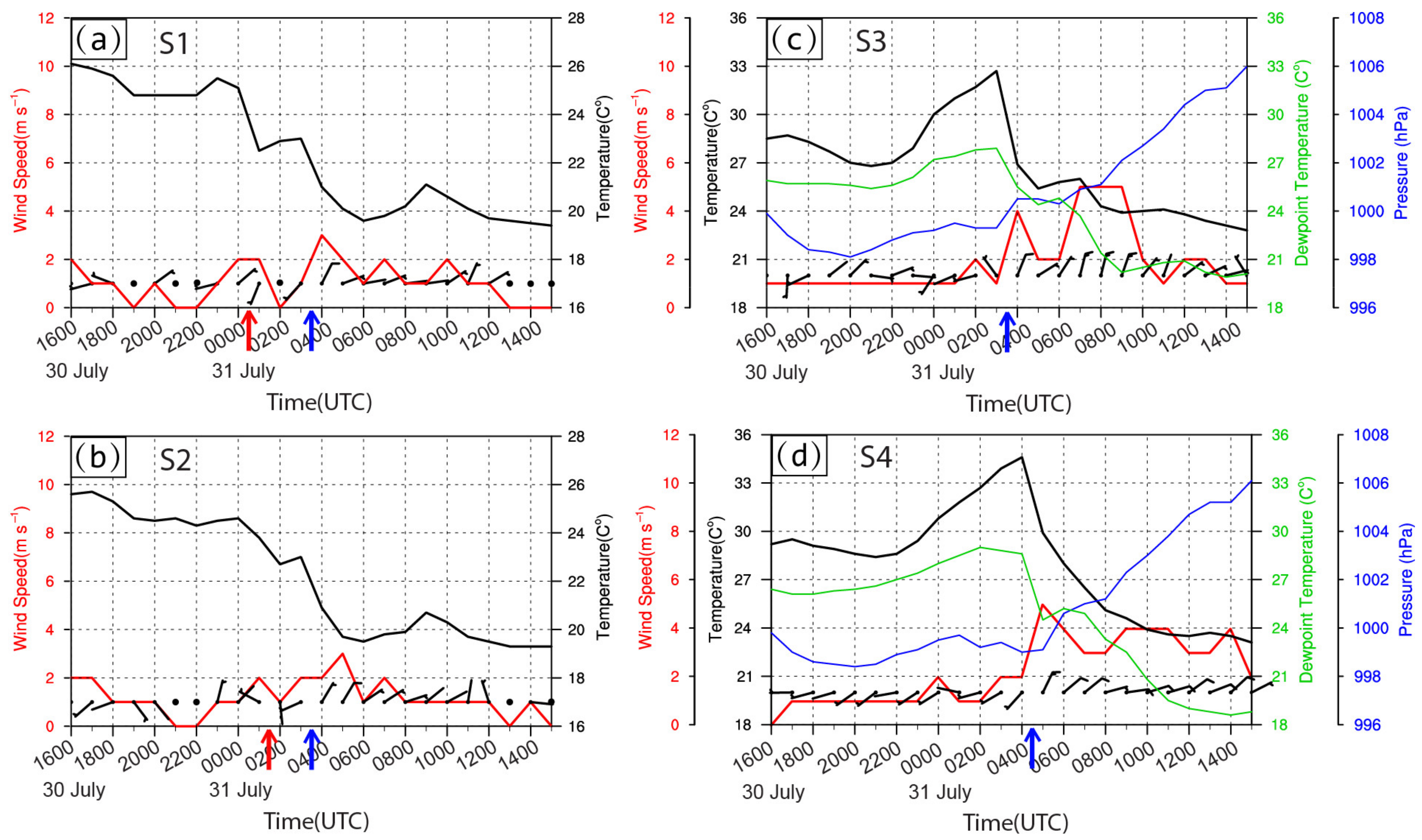
In order to investigate the basic dynamical and thermal characteristics of the SBF and GF, four ground-based automatic weather stations (S1, S2, S3, and S4 in Figure 1a) were selected near the merging area. The northeastern SBF showed an immature, weak, and quasi-stationary state during the whole merger process. Therefore, there was no obvious evidence related to the typical SBF recorded by the automatic weather stations near the northeastern SBF. Therefore, we selected two stations (i.e., S1 and S2) located near the southwestern SBF. Figure 4a,b show the basic characteristics of the southwestern SBF such as temperature drop and significant wind direction change. As the southwestern part of the SBF penetrated toward inland, it passed the station S1 during 0000–0100 UTC 31 July (indicated by red arrow). During this period, the wind direction was turned from northeasterly to south-southwesterly, with the temperature decline reaching ~2.5 °C. Similar temperature drop and wind shift were observed at S2 during 0100–0200 UTC 31 July, reflecting the passage of the SBF (the wind direction was changed from northwesterly to southerly, temperature decline reaching ~1.2 °C). There was ~1 h time lag between the time of the passage of the SBF in S1 and that of S2, which is likely due to the relatively northeast geographical location of the S2, such that the passage time of the SBF was slightly later than that of the station S1. Furthermore, the wind direction changed from southwesterly to northeasterly at both stations (i.e., S1 and S2) between 0300 and 0400 UTC 31 July (denoted by blue arrow), indicating the passage of the GF. In this period, the wind speed observed by S1 was increased from ~0.5 m s−1 to ~2.5 m s−1, while the similar wind speed increasing at S2 was delayed ~1 h (increased from ~2 m s−1 to ~3 m s−1 during 0400–0500 UTC 31 July).
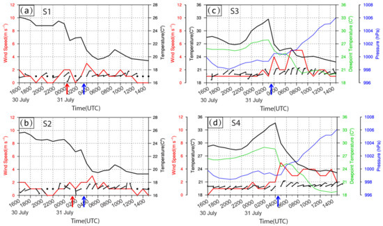
Figure 4.
(a–d) Evolution of observed temperature (black lines, units: °C), dewpoint temperature (green lines, units: °C), pressure (blue line, units: hPa), and wind information (red lines show the wind speed, half and full wind barbs represent 2 and 4 m s−1, respectively) from 1600 UTC 30 July to 1500 UTC 31 July 2010 at ground-based automatic weather stations S1, S2, S3, and S4 (see the locations of S1, S2, and S3 in Figure 1a). The dewpoint temperature and pressure were absent because they were missing in S1 and S2 during this period. The missing winds are indicated as black dots. The red and blue arrows indicate the time of temperature drop and wind shift induced by the passage of the SBF and GF, respectively.
The wind direction at S3 changed from northwesterly to north-northeasterly, with a relatively significant increase of wind speed from ~1 m s−1 to ~4 m s−1 in the period between 0300 and 0400 UTC 31 July, denoting the passage of the GF. Furthermore, a significant temperature drop (reaching ~6 °C), a pressure jump (reaching ~1 hPa), and a decrease in dewpoint depression (T-Td, reaching ~3.5 °C) occurred at S3 in the same period. As for the S4, decrease of temperature and dewpoint (reaching ~4.5 °C), and changes in wind speed (increased from ~2 m s−1 to ~5 m s−1) and wind direction (changed from southwesterly to northeasterly) occurred during 0400–0500 UTC 31 July, indicating the passage of the GF. However, the pressure jump (reaching ~1.5 hPa) and decrease in dewpoint depression (T-Td) (reaching ~3 °C) occurred ~1 h later (i.e., between 0500 and 0600 UTC). Such lag, which was also found in the observation at S2, was commonly observed and studied in depth in Schultz [42] by reviewing a number of different mechanisms for prefrontal troughs and wind shifts. The similar time lag was also reported in Abulikemu et al. [37]. In general, the passage of the SBF caused obvious wind shift and temperature drop, while that of GF induced remarkable increase in pressure, moisture, and wind speed (with significant wind shift), as well as the decline in temperature. Both the GF and SBF possessed some characteristics that were similar to a cold front.
2.2. Environmental Conditions
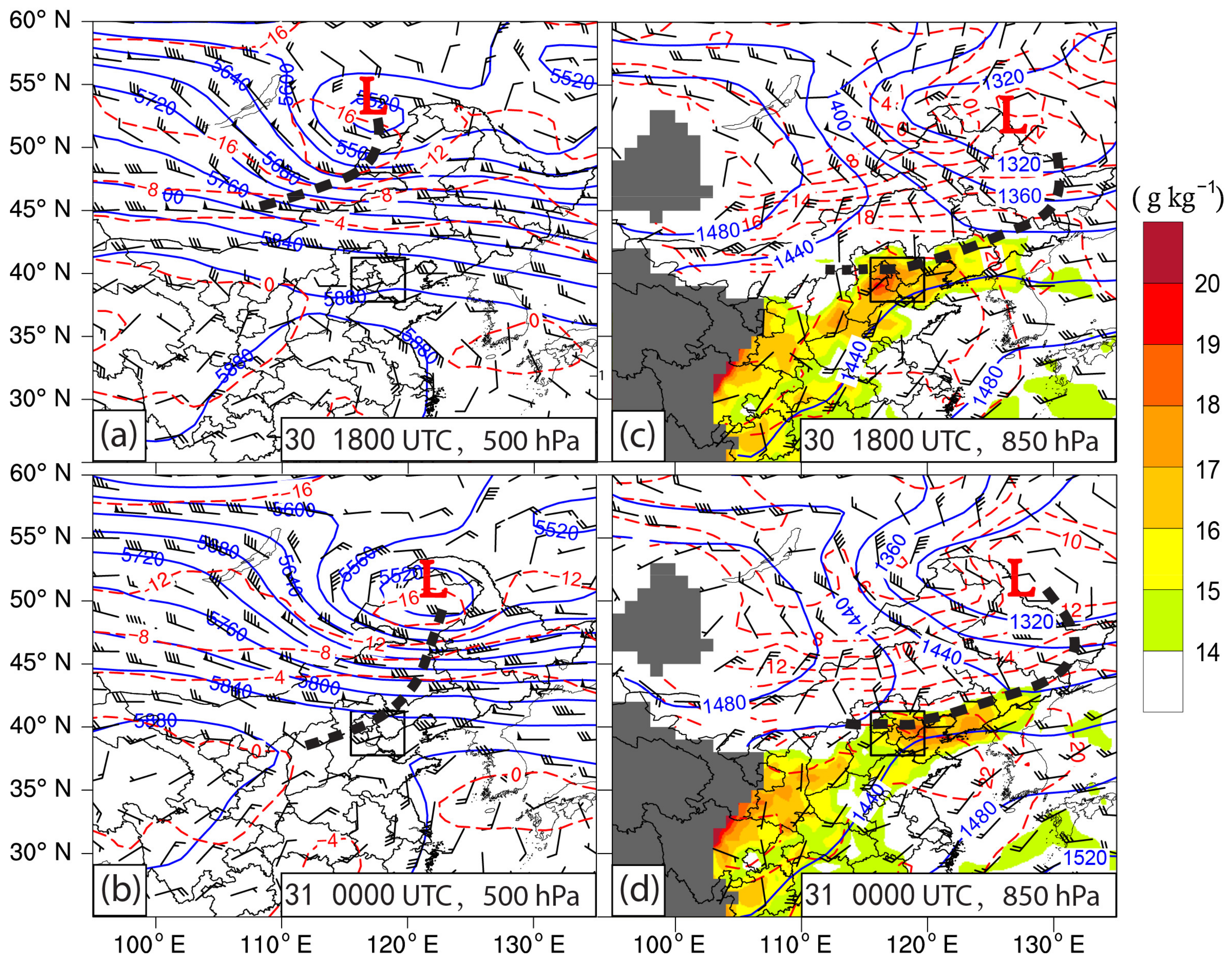
In order to study the environmental conditions of this convective storm, the 6-hourly, 1° × 1° gridded National Centers for Environmental Prediction (NCEP) Final (FNL) analysis data set (https://rda.ucar.edu/datasets/ds083.2/, accessed on 17 April 2021) was applied. At about 1200 UTC 30 July, a low pressure vortex began to occur in mid-troposphere (500 hPa) over the area near the eastern Baikal Lake southern Siberia, Russia, in association with a trough (figure not shown). At 1800 UTC 30 July (Figure 5a), the low pressure vortex (indicated by “L”) further developed during its continuous eastward movement. Meanwhile, the trough moved over the area near the border of eastern Mongolia and Inner Mongolia Province, China. At this time, the location of the low center at 850 hPa (Figure 5c) obviously shifted to the southeast where it was almost collocate with the northeastern border of Northeast China. Meanwhile, the trough extending from the low center had reached to the area over the northern boundary of the Shaanxi Province. The southern part of the trough was located over the northern part of the study area, delivering cold northerlies from the north. However, the central and southern part of the study area was controlled by a warm and moist air providing southwesterlies ahead of the trough (the maximum water vapor mixing ratio exceeding 18 g kg−1). Furthermore, a convergence can be generated by the northerlies and southwesterlies which came from either sides of the trough over the study area.

Figure 5.
(a–d) Geopotential height (blue lines, units: gpm), temperature (red lines, units: °C), and wind fields (half barbs, full barbs, and flags represent 2, 4, and 20 m s−1, respectively) derived from NCEP FNL data in July 2010. The specific time and isobaric surface levels are shown in the lower right corner of each panel. The shaded color area in (c,d) represent the water vapor mixing ratio (units: g kg−1) in excess of 14 g kg−1, the dark gray shadings show the plateau or mountainous area with ground pressure below 850 hPa. The thick black dashed lines indicate the trough, the small rectangle area in all panels denote the study area shown in Figure 1a. The letter “L” indicates the low pressure center.
By 0000 UTC 31 July, the low center at 500 hPa (Figure 4b) had moved southeastward at a relatively faster speed. The associated trough was located over the area extending from northeastern China to the study area. At this time, the southern part of the trough had moved over the northwestern part of the study area. Consequently, the northwestern study area was affected by relatively strong cold northwesterlies which were delivered by the trough, while the southern part of the study area was controlled by the southwesterlies in front of the trough. Meanwhile, in the lower troposphere (i.e., 850 hPa, see Figure 5d), the northern part of the trough moved further eastward, while its southern part showed a quasi-stationary state over the area extending from Liaoning Province to the northern part of Shaanxi Province. The major part of the study area was still dominated by the southwesterlies which were continuously providing warm and moist air in front of the trough. Furthermore, a continuous convergence occurred in the lower troposphere over the study area due to the quasi-stationary trough. In general, relatively strong cold advection associated with the northwesterlies behind the trough in mid-troposphere, and the low-level convergence associated with the quasi-stationary trough at 850 hPa, as well as the transportation of the warm and moist air by the soutwesterlies in front of the low-level trough, provided a quite favorable condition for the genesis of the severe convective storms.
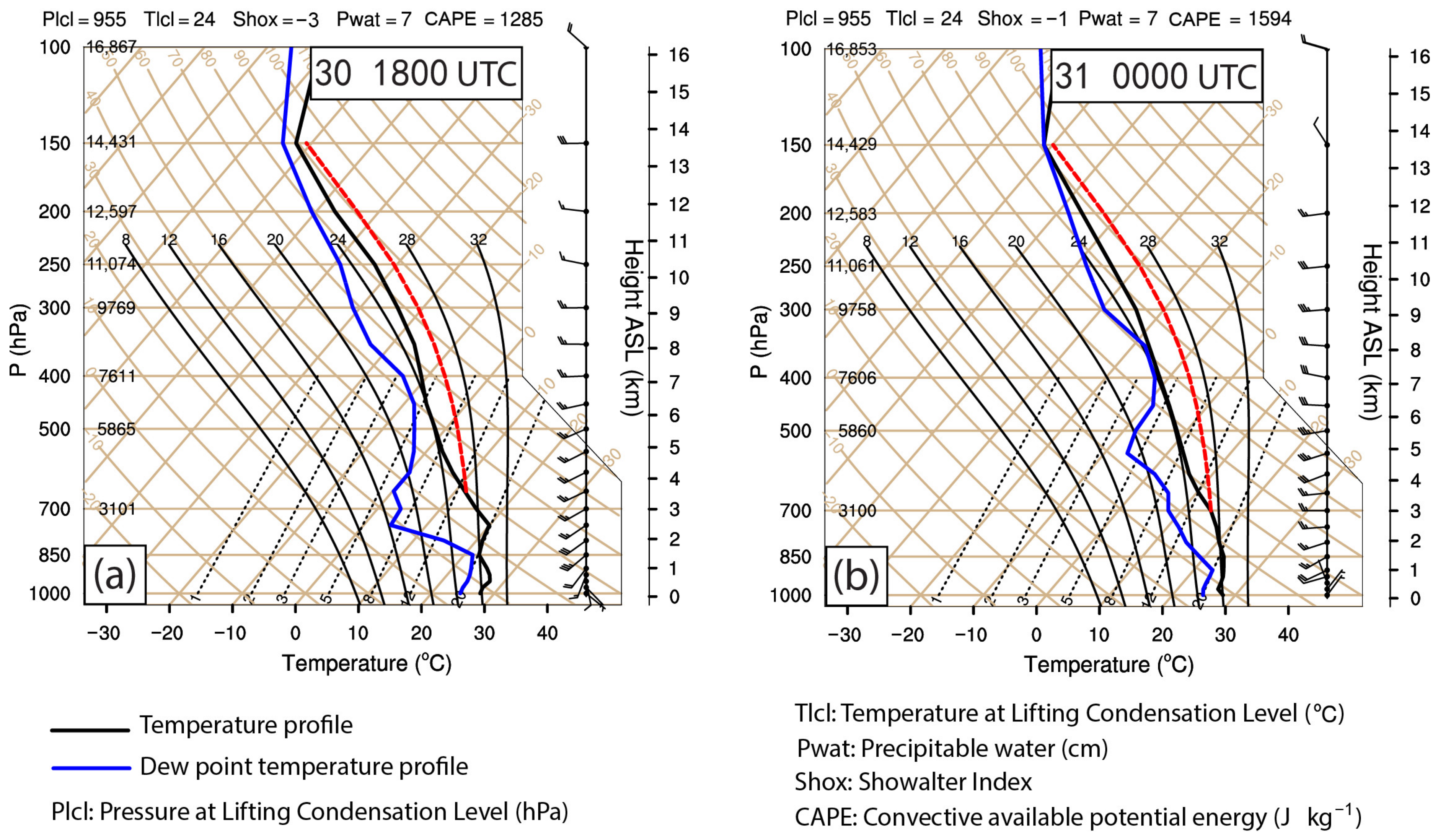
The NCEP FNL reanalysis data were adopted as radiosonde data because there was no real sounding observation in the merging area. It can be seen from the sounding data at 1800 UTC July 30 (Figure 6a) that the convective available potential energy (CAPE) near the merging area reached 1285 J kg−1. The layer at 850 hPa was nearly saturated, and the dewpoint depression (T-Td) was ~1.5 K. The low layer below 850 hPa showed relatively wet condition with dewpoint depression less than 4 K. However, humidity decreased quickly in the level between 850 hPa and ~750 hPa, with showing a dewpoint depression of ~16 K at ~750 hPa. This kind of water vapor condition in which the dry air overlaid on the wet layer below indicates an unstable stratification. Besides, there was a warm advection in the low level below 850 hPa, which was indicated by the veering wind shear, along with a moderate intense vertical shear (reaching ~12 m s−1) of the horizontal wind from ~975 hPa to 850 hPa.
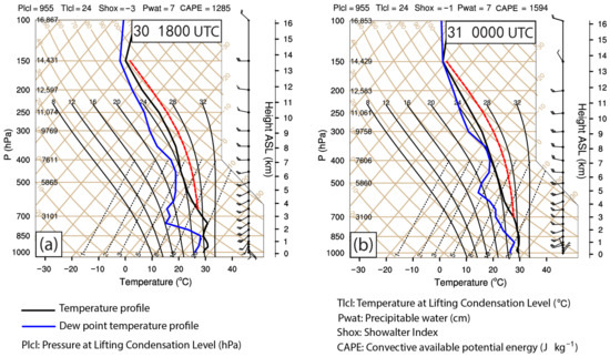
Figure 6.
(a) Skew T-logP diagram derived from the NCEP FNL data (the location is marked with symbol “☆” in Figure 1) at 1800 UTC 30 July 2010; (b) is the same as (a) but for the time at 0000 UTC 31 July 2010.
By 0000 UTC 31 July (Figure 6b), the CAPE increased to 1594 J kg−1, and a warm advection in the low level from 925 to 700 hPa denoted by the veering vertical wind shear was also identified, in association with a moderately intense vertical wind shear (~8–10 m s−1) from 925 to 500 hPa. This kind of environmental condition was conductive to the formation and development of the convective weather to some extent [42]. Moreover, the moisture condition showed that the low layer below 900 hPa was still quite wet (dewpoint depression <3 K). However, the dewpoint depression increased with height above 900 hPa, and the dewpoint depression reached ~8 K at ~700 hPa. The humidity increased slightly with height above 700 hPa, showing a dewpoint depression of ~5 K at 650 hPa. Whereas, another relatively dry air mass can be found in the level of about 600–500 hPa, with a dewpoint depression of ~10 K at ~550 hPa. Again, there was one more wet level (dewpoint depression reaching ~2 K) above at the height of 400–450 hPa. This kind of atmospheric stratification alternated with relatively wet and dry air mass (i.e., relatively stable and unstable) which challenged the initiation and development of convection.
In general, the CAPE has been increased with time over the study area before the CI and development of the convective weather. Additionally, the warm advection and moderate vertical wind shear in the lower troposphere were favorable for the CI and further development of the convection. However, there were some other factors that challenge the CI and development of convection. In the next section, we will further study the mechanism of the CI associated with the merger of the SBF and GF by using high spatio-temporal resolution simulation data.
3. Numerical Simulation
3.1. Setup of Numerical Experiment
The simulation was conducted by using the Weather Research and Forecasting (WRF) model with the Advanced Research dynamics core (ARW) [43]. The model was configured with two-way nested quadruple-level domains, with horizontal grid spacings of 45 km, 9 km, 3 km, and 1 km, respectively (Figure 1b). Due to the limitation of the computational cost, the resolution of the outermost domain was set to 45 km which was five times that of the second domain (i.e., the grid ratio was 5). This kind of performing was also found in previous literature [14,44]. The innermost domain (d04) has 486 × 465 grid points, and fully covered the area where the convective storm of interest occurred (Figure 1a). There were 55 vertical levels (terrain-following) from the surface to the model top at 50 hPa. For all four domains, the models’ physics adopted the WRF Double-Moment 6-class (WSM6) microphysics scheme [45], the Yonsei University, Seoul, Korea (YSU) planetary boundary layer (PBL) scheme [46], the Dudhia Shortwave Scheme [47], the Rapid Radiative Transfer Model (RRTM) for longwave and shortwave radiation schemes [48], and the Unified Noah land-surface model [49]. Moreover, the Kain–Fritsch scheme [50] was used for cumulus parameterization in domains d01 and d02, while it was turned off in domains d03 and d04. The combination of above physical parameterization schemes were selected as the most appropriate combination based on the results of a dozen experiments. The initial and boundary conditions were created by using the 6-hourly NCEP FNL reanalysis data with a resolution of 1° × 1°. All domains were initialized at 1800 UTC on 30 July 2010 and integrated for 18 h. The time intervals of the output data of d04 was 3 min.
3.2. Evaluation of Simulation
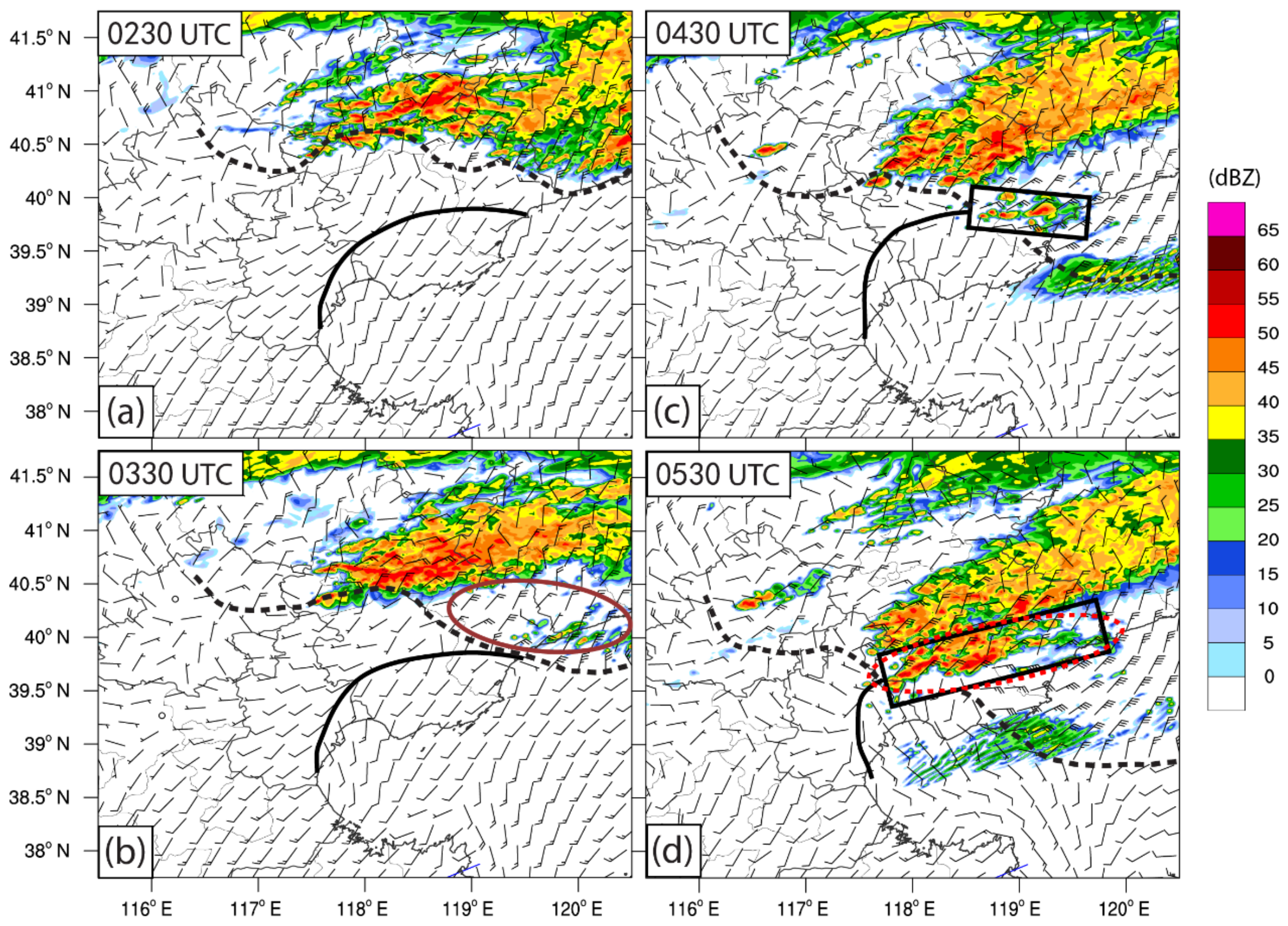
In order to establish the credibility of the simulation, the simulated composed reflectivity and 6-h accumulated precipitation were compared with their observational counterparts in the following. As shown in Figure 7, the simulated MCS and associated GF developed about 0.5 h later than their observational counterparts. Moreover, the overall intensity of the simulated MCS was overestimated to some extent (Figure 7a). Nevertheless, they kept moving toward south-southeastward at a relatively faster speed, and finally merged with the northern part of a slow-moving SBF at about 0300 UTC (i.e., later ~0.5 h than observation) over the southeastern coastline of the Hebei Province, where it was displaced by about 50 km to the east. Besides, the convective system behind the eastern part of the GF was significantly weakened and (or) dissipated (Figure 7b), in agreement with observation. At 0430 UTC (Figure 7c), the GF further moved southward, and many CIs occurred in the area where they merged. In the following ~1 h (Figure 7d), most of the previously initiated convections in the merging area were further developed and merged together, forming a new intense quasi-linear convective system to the south of the elder MCS. The newly generated convective system in the merging area roughly oriented in northeast-southwest direction, which was also consistent with that of observation.
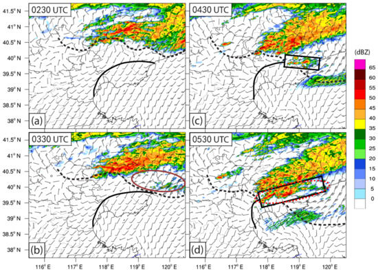
Figure 7.
(a–d) Simulated composite reflectivity (shading, units: dBZ) and wind field (full and half barbs represent 4 and 2 m s−1, respectively) at 10 m height above the ground on 31 July 2010. The black solid lines indicate the locations of the SBF, and black dashed lines denote the locations of the GF. The black rectangle area indicates the merging area. The solid brown ellipse shows the area where the convective system significantly weakened and (or) dissipated. The dotted red ellipse indicates the area where convections initiated and (or) intensified due to the merger of the SBF and GF. The specific time is shown in the upper left corner of each panel.
Figure 8 denotes the comparison of simulated 6-h accumulated precipitation with that of observation obtained by ground-based automatic weather stations. Different colorful symbols were used to reveal the intensity of the observed 6-h accumulated precipitation at each station, because several common interpolation methods (e.g., Inverse Distance Weighted Interpolation, Cressman Interpolation, Natural Neighbor Interpolation, and Tension Splines Interpolation) we had tried could not provide a satisfying distribution of the precipitation. As shown in Figure 8a, the distribution of the observed 6-h accumulated precipitation generated by the convections, which were initiated and (or) intensified due to the merger of the SBF and GF, roughly showed a zonal distribution along the northeast-southwest direction along the coastal area extending from southeastern Hebei to southern Tianjin. The simulated 6-h accumulated precipitation pattern (Figure 8b) showed a similar zonal distribution to the observed corresponding precipitation which was due to the merger of the SBF and GF, despite that it failed to capture the heavy precipitation over the northern part of Tianjin.
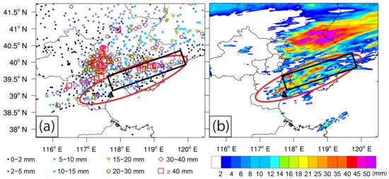
Figure 8.
(a) Observed 6-h accumulated precipitation (colorful symbols, units: mm) observed by the ground-based automatic weather stations from 0200 to 0800 UTC on 31 July 2010; (b) Simulated 6-h accumulated precipitation (shading, units: mm) during the same period as (a). The black rectangle area indicates the merging area of the SBF and GF. The red ellipses indicate the area where precipitations were generated by the convections which were initiated and (or) intensified due to the merger of the SBF and GF.
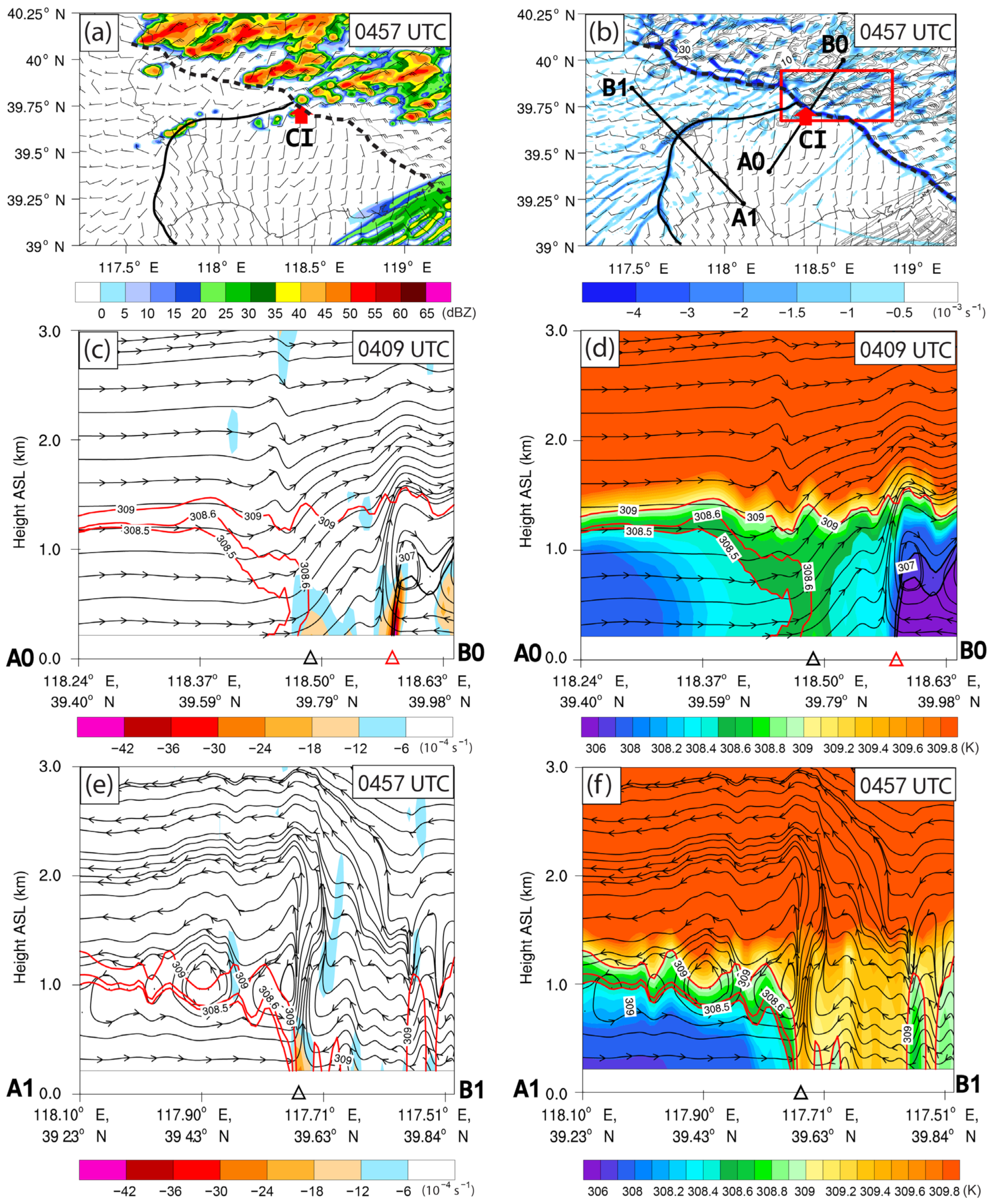
As shown in Figure 9a,b, significant near-surface convergent boundary lines (with obvious wind shift) can be found at the leading edges of both SBF and GF. A vertical cross section along the northeast-southwest direction near the delta-shaped merging area, where several CIs occurred repeatedly, showed that (Figure 9c,d) the SBF revealed a relatively weak divergent leading edge, along with relatively weak thermal boundary (i.e., 308.5 K and 308.6 K isotherms) up to ~1.2 km AGL (Above Ground Level). However, there was no vertical rotor circulation (i.e., closed vertical circulation) near the leading edge of the SBF. Besides, the Kelvin–Helmholtz Billows (KHBs) behind the head of the SBF and front-to-rear return flow aloft were absent here. Therefore, it is further confirmed from the perspective of the above absent structures or circulations of the SBF, that the northeastern part of the SBF is in an immature state. The southwestern part of the slow-moving SBF showed (Figure 9e,f) relatively mature features and that there was an intense convergent boundary at the leading edge of the SBF, with a pronounced vertical rotor circulation following closely to the leading edge. Besides, there was an obvious feeder flow in the low level below ~0.5 km AGL toward the leading edge, along with a front-to-rear return flow above ~1 km AGL reaching to ~2.5 km AGL. The thermal boundary of the SBF (reaching ~1 km AGL, indicated by isotherms of 308.5 K and 309 K) was also remarkable, following closely to the dynamic boundary (i.e., convergent boundary). Although the northeastern part of the SBF revealed a weak and immature quasi-stationary pattern, the features of the southwestern part of the SBF substantially displayed typical characteristics of a mature SBF, in agreement with the observation.
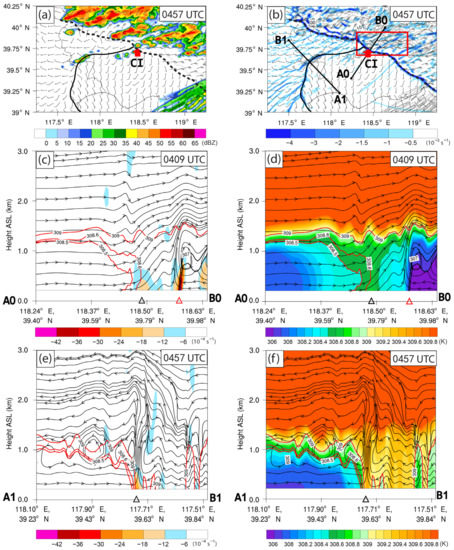
Figure 9.
(a) Simulated composite reflectivity (shading, units: dBZ) and wind field (full and half barbs represent 4 and 2 m s−1, respectively) at 10 m (AGL) at 0457 UTC on 31 July 2010. The black solid and dashed lines indicate the locations of the SBF and GF, respectively. The red arrow indicates the selected convective cell; (b) is the same as (a) but for the horizontal divergence (shading, units: 10−3 s−1) at the bottom level of simulation and composite reflectivity (black contours, units: dBZ), the line segments A0B0 and A1B1 show the locations of the vertical cross sections which will be shown in (c–f). The red rectangle area shows the area for calculating the zonal-mean value of horizontal divergence, horizontal wind velocity, and vertical wind shear which will be shown in Figure 15; (c) The vertical cross section of horizontal divergence (shading, units: 10−4 s−1), wind stream (stream lines), and potential temperature (red solid contours, units: K) along the line segment A0B0. The black and red triangle symbols indicate the locations of the leading edges of the SBF and GF, respectively; (d) is the same as (c) but for the potential temperature (shading and red solid contours, units: K); (e) is the same as (c) but shows the cross section along the line segment A1B1; (f) is the same as (d) but shows the cross section along the line segment A1B1.
In general, the overall pattern and motion of the MCS and associated GF as well as the slow-moving SBF from Bohai Sea were well captured by the simulation despite some slight biases in time, location, and intensity. Besides, the intensity and overall distribution of the 6-h accumulated precipitation which resulted from the merger of the SBF and GF were also in good agreement with the observation. Therefore, the simulation results were considered to be reliable for the analysis of the CI mechanism related to the merger of the two mesoscale fronts in the next.
4. Convection Initiation
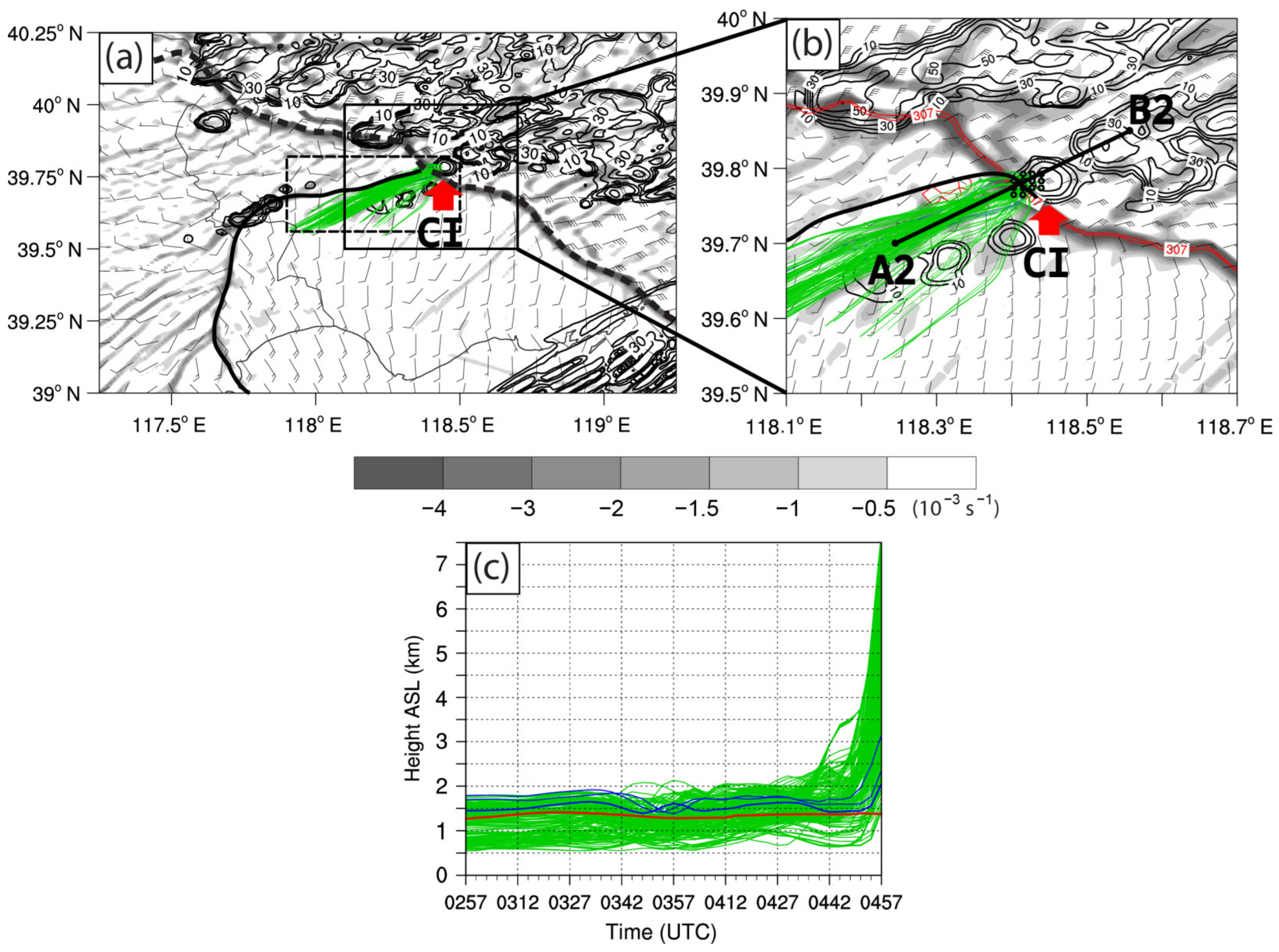
In order to investigate the mechanism of CI associated with the merger of the SBF and GF, a typical convective cell (indicated by the red arrow in Figure 9a,b) was selected to perform Lagrangian vertical momentum budget analyses along the backward trajectories of air parcels within the cell. The typical convective cell was initiated at 0457 UTC (i.e., the maximum reflectivity reached 35 dBZ for the first time), and it was one of the fast-developing convective cells initiated repeatedly in the merging area. The backward trajectories were calculated using the fourth-order Runge–Kutta scheme [14,38,51]. The air parcels within the cell were released at 0457 UTC and traced backward for 2 h. Furthermore, the air parcels with vertical velocities in the top 25% quantile at the CI time were selected for further investigation [4], for the sake of concentrating on the parcels which were mainly responsible for the CI. As shown in Figure 10a,b, the air parcels came from southwest of the convective cell. Figure 10c showed the height variation of the air parcels during the 2 h period prior to CI. Most of the air parcels came from below the area-mean planetary boundary layer height (PBLH) (i.e., the red line in Figure 10c) calculated in the area that the air parcels had gone through (shown in the black dashed rectangle in Figure 10a), while only about 1.8% of these parcels came from above the PBLH. Therefore, this convective cell can be considered as a surface-based convection. It is similar to the case [38] in which CI occurred prior to the merger of an SBF and a GF. In that case, about 75% of the parcels came from below the PBLH. However, it is quite different from the case [14] in which only about 8.9% of the parcels came from a low level below the PBLH. As can be seen from the height variation of the air parcels during the 2 h period prior to CI (Figure 10c), the most significant ascending occurred in the last 0.5 h period, while there were some weak fluctuations in the height of the air parcels during the early 1.5 h period. Consequently, only the features of air parcels in the last 0.5 h period before the CI will be investigated in the following.

Figure 10.
(a) Simulated horizontal divergence (shading, units: 10−3 s−1), composite reflectivity (black contours, units: dBZ, with 10 dBZ intervals), wind field (full and half barbs represent 4 and 2 m s−1, respectively) at 10 m (AGL), ground-relative backward trajectories (green and blue lines, projected to the ground) of air parcels for 2 h within the selected convective cell (indicated by red arrow) at 0457 UTC on 31 July 2010. The black solid and dashed lines indicate the locations of the SBF and GF, respectively. The black dashed rectangle area shows the area for calculating the area-mean planetary boundary level height (PBLH) shown in (c); (b) is the magnified area of the black sold rectangle area in (a). It also shows the potential temperature (red solid contours at values of 306 and 307 K) that indicates the thermal boundary of the GF. The line segment A2B2 shows the location of the vertical cross section that well be shown in Figures 12–14; (c) Height along the backward trajectories of air parcels with vertical velocities in the top 25% quantile at the CI time within the selected convective cell. For parcels higher (lower) than PBLH in the 2 h period, they are colored in blue (green). The height of the PBLH is in red.
The vertical acceleration can be decomposed into two parts according to Jeevanjee and Romps [52], namely, buoyant acceleration () and dynamic acceleration (), i.e.,
where and can be obtained from the following Poisson equations:
where and are the three-dimensional (3D) and horizontal Laplacian operators, respectively; g is the acceleration of gravity, is the total density including hydrometeors, represents the base-state air density which is a function of height (anelastic approximation), is the 3D wind. According to Jeevanjee and Romps [52], is defined as the Lagrangian vertical acceleration due to the horizontal variation of density, including both the Archimedean buoyancy () and the response of environment to the acceleration due to the . , is the density perturbation relative to . The ambiguities in the arbitrary definition of the base state density can be avoided via this definition, as mentioned in many previous studies [45,53,54]. is defined as the Lagrangian vertical acceleration resulting from the instantaneously zeroing out of all anomalies of horizontal density. The multigrid software for elliptic partial differential equations (abbreviated as MUDPACK) [55] was used to solve the above two Poisson equations [56,57]. The Direchlet boundary conditions ( = 0 and = 0) were adopted on both the bottom and top boundaries. These were considered as the most appropriate and unambiguous boundary conditions [52].
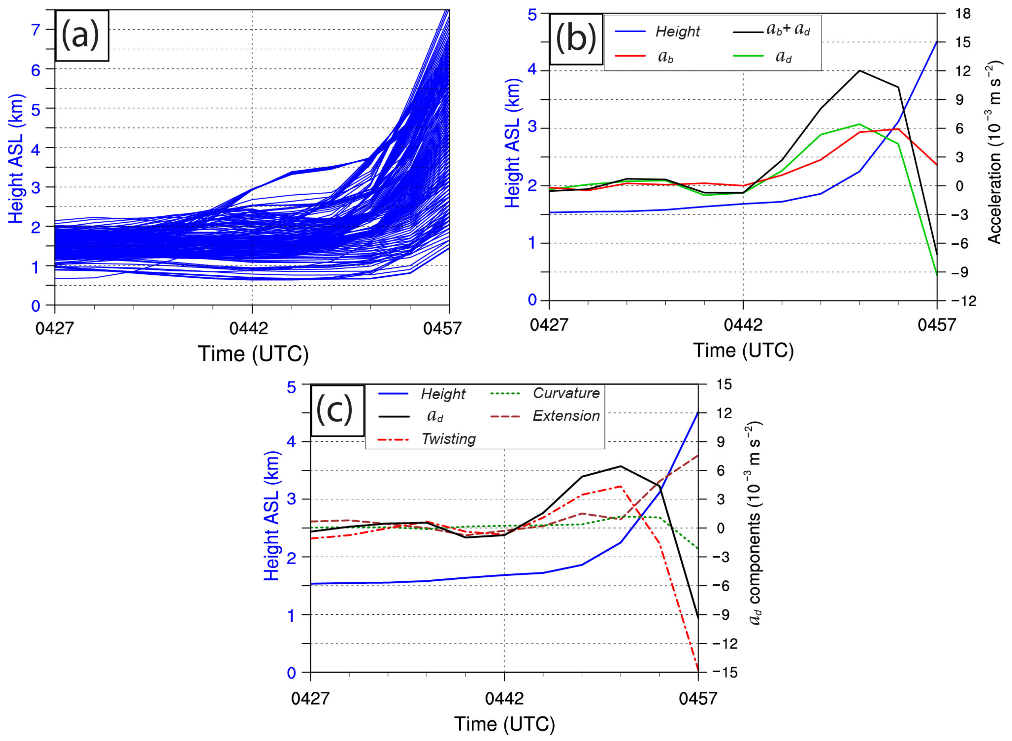
As shown in Figure 11a, in the last 0.5 h before the CI, most of the air parcels significantly lifted after 0442 UTC, while a small number of them began to ascend before 0442 UTC. Figure 11b shows the time evolutions of the averaged height, vertical momentum tendencies induced by buoyancy (), dynamical force (), and sum of them (+) along all the air parcels selected within the convective cell in the 0.5 h period before the CI. The averaged height of the parcels displayed a slow lifting pattern in the early ~15 min, while it increased significantly in the last ~15 min. In the early 15 min period, both of them were rather small, showing some perturbation. However, both of the and increased obviously during the last 15 min rapid lifting period. During 0445–0451 UTC, the was remarkably greater than , while the became greater than in the last ~5 min. In general, from the overall perspective of averaged trajectory of air parcels, both of the and played crucial rules for the CI.

Figure 11.
(a) Height along the backward trajectories of air parcels with vertical velocities in the top 25% quantile at the CI time (i.e., 0457 UTC) within the selected convective cell in 30 min before CI; (b) Averaged height and vertical momentum components induced by dynamic force (), buoyancy (), and sum of them ( + ) along the air parcels selected within the convective cell in 30 min before CI; (c) Averaged height, dynamic acceleration (), and its three components (Curvature, Twisting and Extension) in 30 min before CI.
In order to further investigate the intuitional physical meanings of , the forcing term on the right-hand side (RHS) of Equation (3) was decomposed into the following components under the assumption of anelastic approximation [58], i.e.,
where the terms (5), (6) and (7) denote the fluid extensions, horizontal curvature, and vertical twisting, respectively. The term (6) is proportional to the vertical vorticity for a pure rotational flow [58], while term (7) can be considered to be related to the horizontal vorticity (i.e., rotation in the vertical plane). Contributions of these three terms to the can be calculated via substituting each of them into the RHS of Equation (3) and solving the relevant Poisson equations.
Figure 11c shows the evolutions of the averaged height, , and its three components along the backward trajectories of selected air parcels. During the 0442–0451 UTC, the twisting term increased significantly, and became remarkably greater than all the other terms, showing a sharp decreasing trend after 0451 UTC. The extension term revealed relatively weak positive contribution during 0445–0451 UTC, along with a very significant increasing trend after 0451 UTC. However, the horizontal curvature term showed relatively small positive effect on during 0448–0454 UTC, while it was almost negligible at other times. In general, the overall evolution of the during the early 10 min of the rapid lifting period was mainly affected by the vertical twisting term, while the extension term had a positive contribution to the during the last 12 min before CI. Especially, the extension term played a very significant positive role in the during the last 5 min before CI.
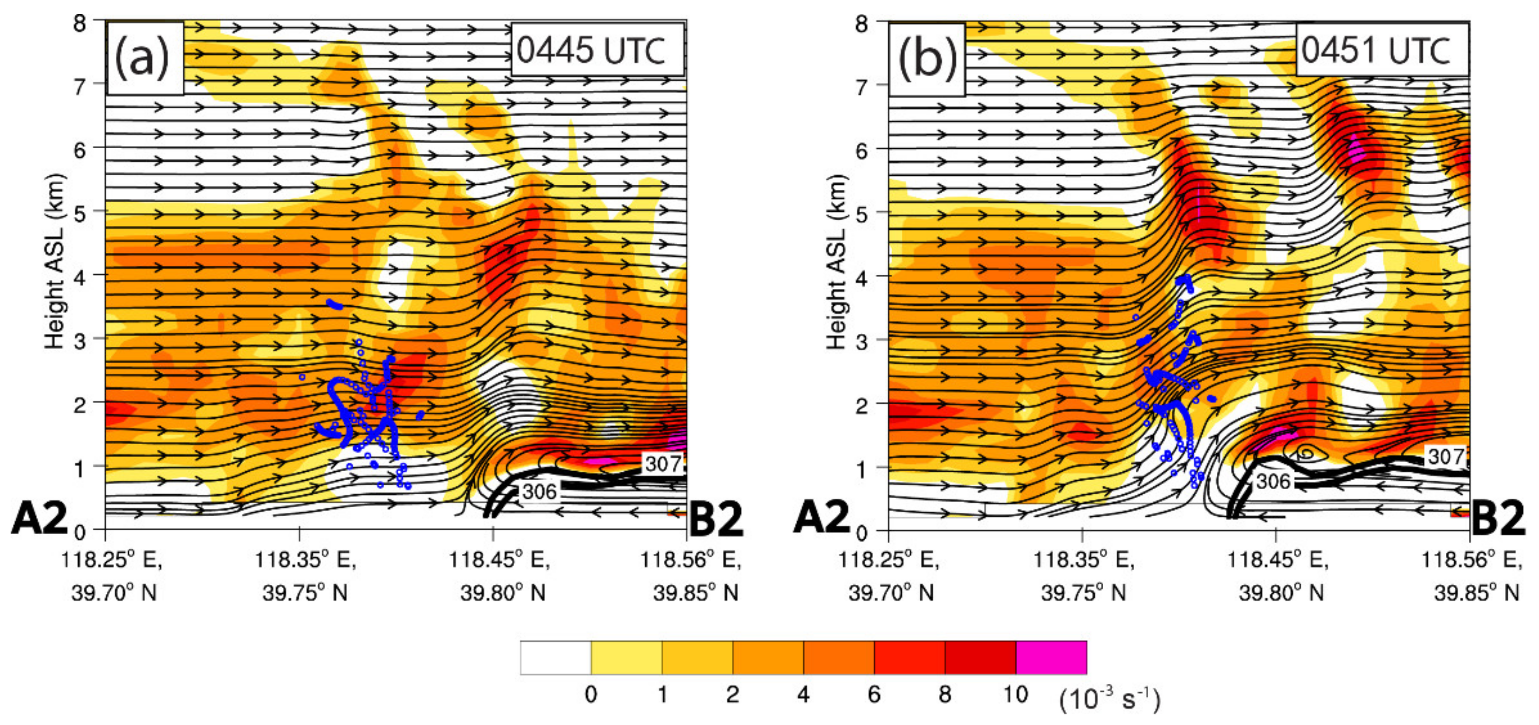
In order to obtain an intuitive grasp of the vertical twisting, the vertical cross section of the vertical shear of the horizontal wind (VSHW) along a line segment, which almost runs parallel through the center of the ground-relative backward trajectories of air parcels, are analyzed (Figure 12). The vertical cross sections of VSHW and locations (projected to the vertical cross section) of the air parcels indicated that (Figure 12a,b) as the air parcels lifted significantly during 0445–0551 UTC, most of the air parcels entered an area with high VSHW. Therefore, it can be inferred that most of the air parcels were affected by an environment with high VSHW where the air parcels exhibited a quite intense vertical twisting (analyzed above) due to the VSHW before the CI.
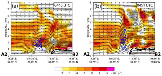
Figure 12.
(a,b) Vertical cross section of the VSHW (shading, units: 10−3 s−1) and streamline along the line segment A2B2 in Figure 10b on 31 July 2010. The small blue circles indicate the location (projected to the vertical cross section) of the air parcels. It also shows the potential temperature (black solid contours at values of 306 and 307 K) that indicates the thermal boundary of the GF. The specific time is shown in the upper right corner of each panel.
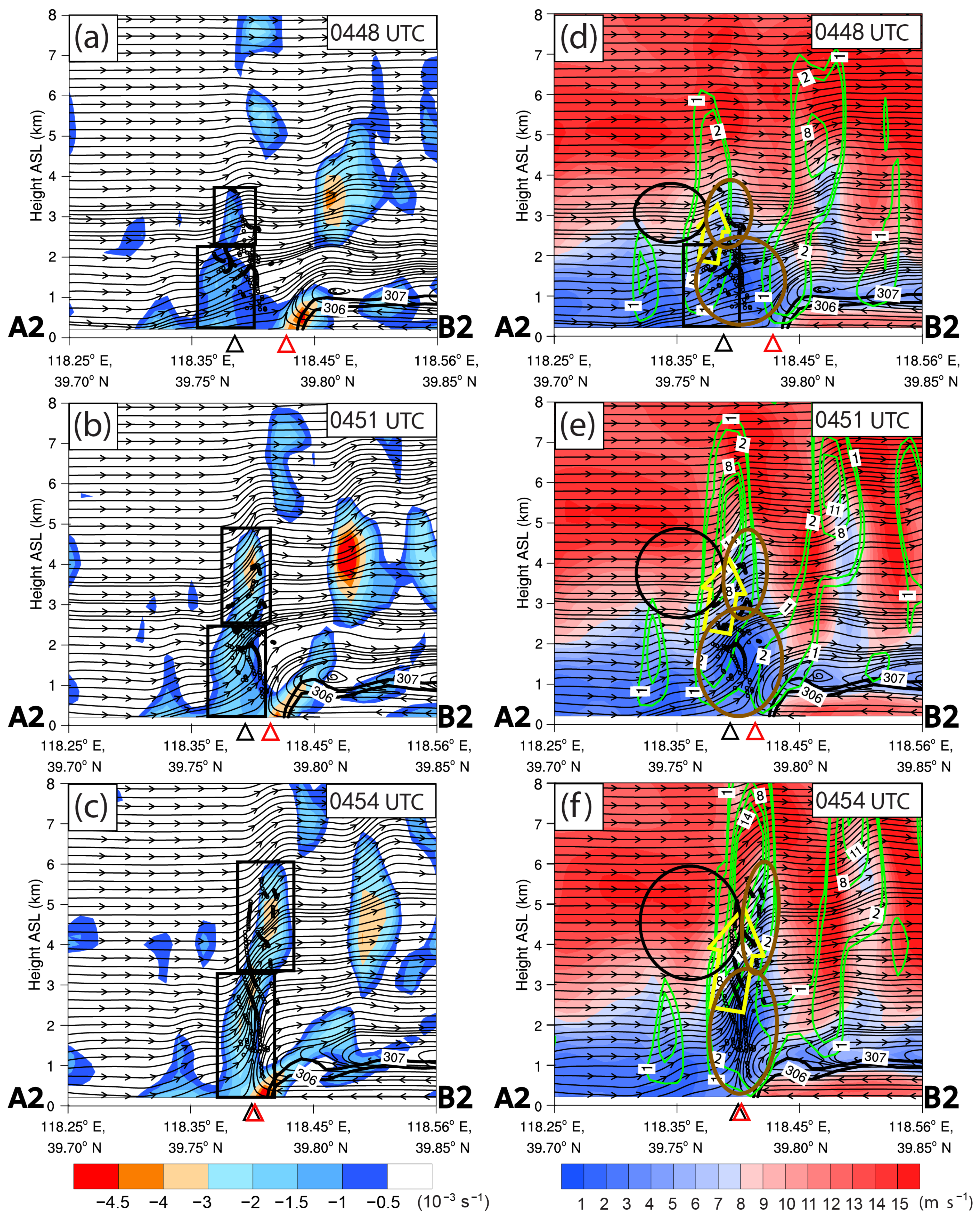
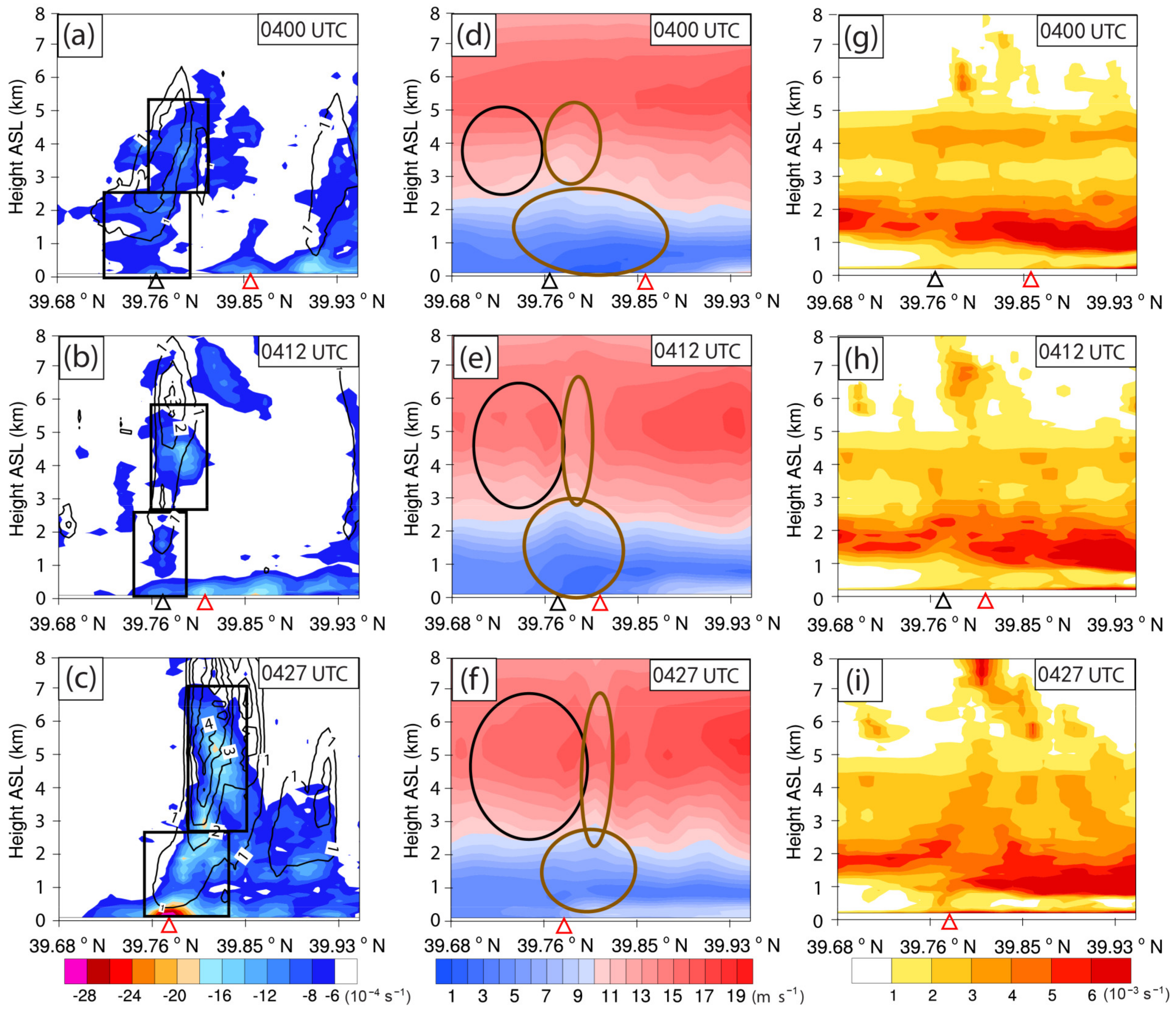
In order to further understand the intuitional physical process of the extension term which had played a significant positive role in the , cross sections of the horizontal divergence, horizontal wind velocity (HWV), as well as the projected locations of the air parcels in the same vertical cross section are analyzed. At 0448 UTC (Figure 13a), there were two weak convergence regions (indicated by two black rectangles) in different levels near the leading edge of the weak and slow-moving immature SBF. It is noteworthy that the northeastern SBF, which was mainly merged with the GF, revealed an immature state that showing a weak and quasi-stationary convergent leading edge without any rotor circulation and front-to-rear return flow (Figure 13a–c), while the southwestern SBF showed typical mature structures with rotor circulation and front-to-rear return flow (Figure 9e,f). Meanwhile, the air parcels moved to the area near the two convergence regions, with roughly the same moving direction as the SBF. The lower convergence region occurred in the lower level below ~2 km AGL, while the upper one was in the height about 2–3.5 km AGL. At this time, there were two weak-wind regions (HWV < ~8 m s−1, indicated by bold brown ellipses in Figure 13d) between the immature SBF and GF, along with a relatively weak updraft (reaching ~2 m s−1, indicated by the yellow arrow) induced by the lower convergence region. These two weak-wind regions were respectively corresponded to the adjacent downstream area of the two convergence regions. The upper weak-wind region was extended upward due to the updraft and squeezing of the two fronts (i.e., the SBF and GF), reaching a higher level up to ~3.5 km AGL. The HWV in the near-upstream area of the upper weak-wind region was rather intense (reaching ~10 m s−1, denoted by black ellipse). As the two fronts moved close to each other, both of the convergence regions underwent significant development both in size and intensity. By 0451 UTC (Figure 13b,e), the outer part of the convergent leading edge of the two fronts began to merge. Meanwhile, the lower convergence region reached ~2.8 km AGL, while the upper one reached a height about 2.5–4.8 km AGL. Furthermore, intensity of both convergence regions increased significantly (most intense divergence in the upper convergence region reached ~−4 × 10⁻³ s−1). Meanwhile, the upper weak-wind region was further elevated (reaching up to ~5 km AGL) due to the updraft and squeezing of the two fronts. Moreover, the HWV in the near-upstream area (denoted by black ellipse) was intensified significantly (reaching 13 m s−1). This high-wind region was called as near-upstream high-wind region (indicated by black ellipse). At 0454 UTC (Figure 13c,f), the SBF and GF had completely merged together, with the two convergence regions further extended upward (the lower one reaching to ~3 km AGL, while the upper one reaching ~6 km AGL). Furthermore, both of the convergence regions became larger, showing more intense convergence in them (especially the lower one, reaching ~−4 × 10⁻³ s−1). Meanwhile, both of the weak-wind regions were also further squeezed and elevated (the upper one reaching to ~6 km AGL). Furthermore, the HWV in the near-upstream high-wind region (denoted by black ellipse) was further intensified (reaching ~15 m s−1).
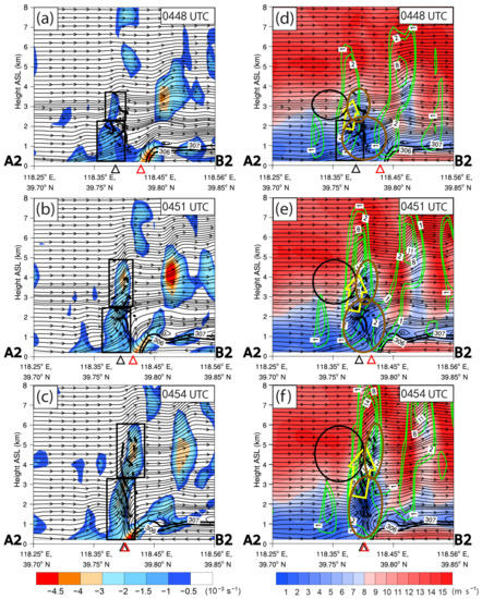
Figure 13.
(a–c) Vertical cross section of horizontal divergence (shading, units: 10−3 s−1) and streamline along the line segment A2B2 in Figure 10b on 31 July 2010. The small black circles indicate the location (projected to the vertical cross section) of the air parcels. The two black rectangles indicate the significant convergence regions in different levels. The black and red triangle symbols indicate the locations of the leading edges of the SBF and GF, respectively. The specific time is shown in the upper right corner of each panel; (d–f) are the same as (a–c) but for the horizontal wind velocity (HWV) (shading, units: m s−1) and vertical wind speed (green contours, units: m s−1). The black ellipses indicate the near-upstream high-wind region, while the bold brown ellipses showed the weak-wind regions in different levels.
It can be inferred from the variation characteristics of the horizontal divergence and HWV during the merger processes of the SBF and GF that the airflow moving from the near-upstream high-wind region to the upper weak-wind region was blocked (or decelerated), obviously due to the significant velocity difference between these two regions. Consequently, a blocking (or deceleration) effect was formed in the mid-level area between the near-upstream high-wind region and upper weak-wind region (i.e., the junction area between the black ellipse and upper bold brown ellipse), and generated a significant convergence in the mid-level (i.e., 3–6 km AGL), which was called mid-level blocking convergence effect (MBCE) herein. The upper convergence region was generated and intensified due to the MBCE, and it was almost overlapped with the lower part of the intense updraft (reaching >14 m s−1). Consequently, it can be inferred that the MBCE provided an intense dynamic force for the intense updraft.
The lower convergence region developed due to the squeezing and merging of the convergent leading edges of the immature SBF and GF. Although the immature SBF had rather weak convergent leading edge without any rotor circulation and front-to-rear return flow, it still played an important role for the formation of these two convergence regions and accompanied two weak-wind regions which were critical for the MBCE. During the merger process of the immature SBF and GF, most of the air parcels were within these two convergence regions, and thereby most of them were affected by these two convergences which were reflected as the extension term mentioned above in the vertical budget analysis along the backward trajectories (Figure 11c).
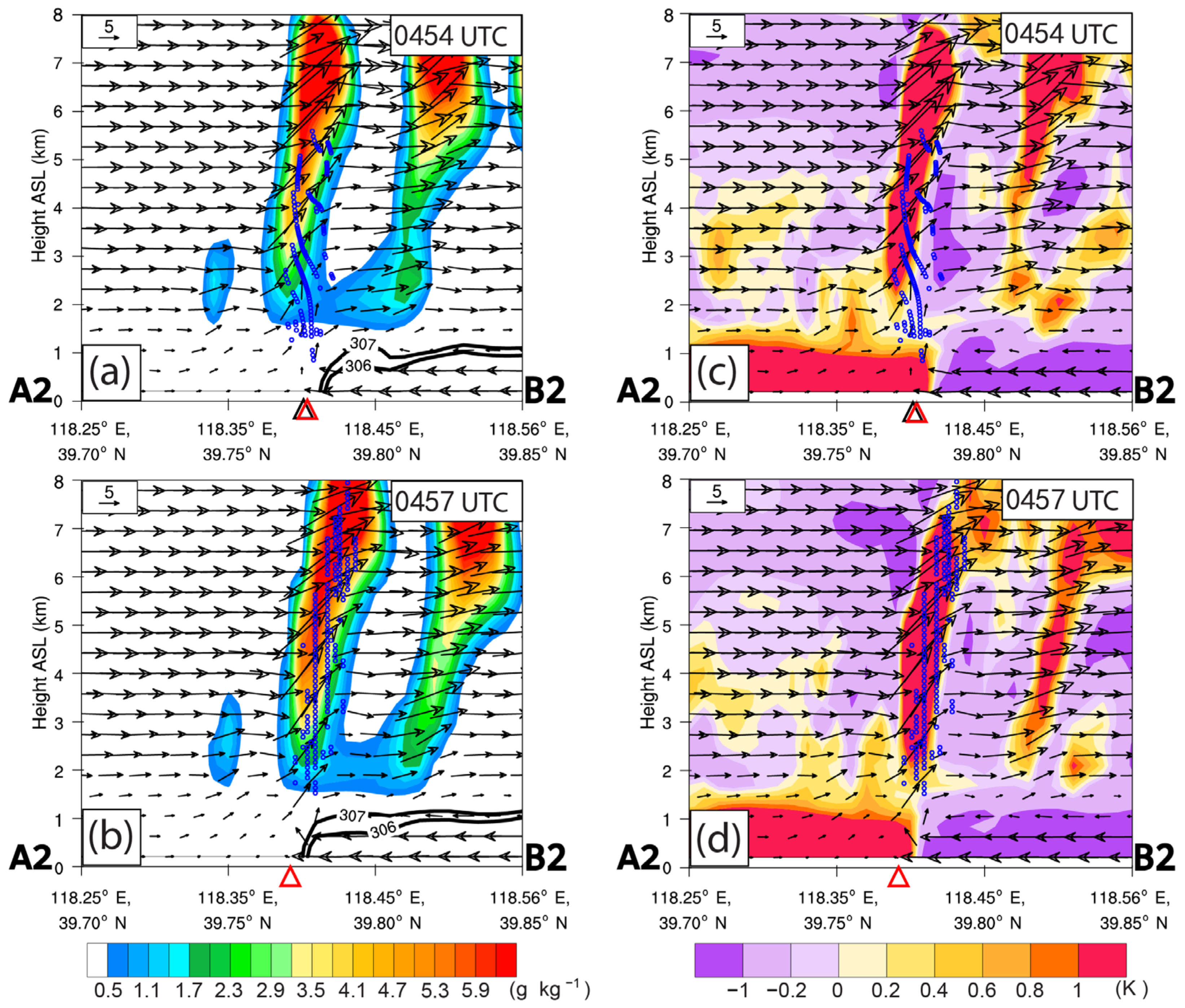
In order to study the possible source of , the vertical cross section of potential temperature anomaly and hydrometeors along the same line segment are analyzed in the following. There was a significant positive potential temperature anomaly in the surrounding environment of the ascending air parcels (Figure 14a,b), which indicated an obvious warming in the surrounding environment. Besides, the area where the significant warming occurred had almost coincided with the area where considerable hydrometeors occurred (Figure 14c,d) owing to the condensation of water vapor when air parcels reached the level of condensation level (LCL). Therefore-, it can be deduced that the release of latent heat was the reason for the warming of the surrounding environment of the air parcels.
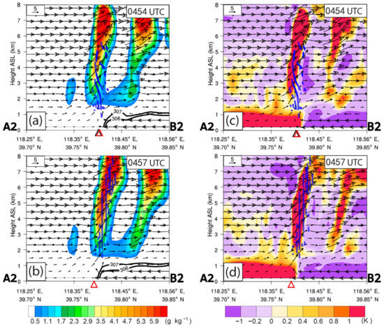
Figure 14.
(a,b) Vertical cross section of the hydrometeors (including rain, cloud, ice, graupel, and snow) (shading, units: g kg−1) and wind fields (vector arrows) along the line segment A2B2 in Figure 10b on 31 July 2010. (c,d) are the same as (a,b) but for the potential temperature anomaly (shading, units: K). The specific time is shown in the upper right corner of each panel. The black and red triangle symbols indicate the locations of the leading edges of the SBF and GF, respectively.
In order to avoid the subjectivity of the above analysis explaining the intuitional physical process of the vertical twisting term and extension term based on a vertical cross section of VSHW, horizontal divergence, and HWV, we will further analyze the zonal-mean value of these three major variables (calculated in the merging area reflected by the red box in Figure 9b) in the following. The zonal-mean horizontal divergence showed that (Figure 15a) there were two weak convergence regions (indicated by two black rectangles) in different levels near the leading edge of the SBF. The lower convergence region occurred in the lower level below ~2.5 km AGL, while the upper one was in the height about 2.5–5 km AGL. The zonal-mean HWV showed that (Figure 15d) there was a weak-wind region (HWV < ~10 m s−1, indicated by the bigger bold brown ellipse) between the two fronts in the lower level below ~2.0 km AGL. It is noteworthy that the isotaches from 10 to 15 m s−1 showed a significant upward convex pattern (indicated by the smaller bold brown ellipse), and the HWV in this upward convex area was lower than the HWV at the same height of the near-upstream area (shown by the black ellipse). Consequently, the upward convex area can be considered as an upper weak-wind region.
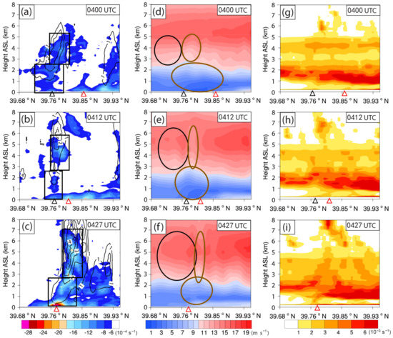
Figure 15.
(a–c) Vertical cross section of the zonal-mean value of the horizontal divergence (shading, units: 10−3 s−1) and vertical wind speed (black contours, units: m s−1) in the red rectangle area in Figure 9b on 31 July 2010. The two black rectangles indicate the significant convergence regions in different levels; (d–f) are the same as (a–c) but for the horizontal wind velocity (HWV, shading, unit: m s−1). The black ellipses indicate the near-upstream high-wind region, while the bold brown ellipses showed the weak-wind regions in different levels; (g–i) are the same as (a–c) but for the vertical shear of the horizontal wind (VSHW, shading, units: 10−3 s−1). The black and red triangle symbols indicate the locations of the leading edges of the SBF and GF, respectively. The specific time is shown in the upper right corner of each panel.
As the SBF and GF come close to each other, both of the weak convergence regions in different levels near the leading edge of the SBF underwent significant development both in size and intensity (Figure 15b,c). Meanwhile, zonal-mean HWV showed that (Figure 15e,f), both of the weak-wind regions were further squeezed, and the upper weak-wind region was elevated further upward (indicated by upper brown ellipse), along with an intensification of the HWV (max HWV reaching ~16 m s−1) in the near-upstream high-wind region (indicated by the black ellipse). Therefore, it can be inferred that the airflow moving from the near-upstream high-wind region to the upper weak-wind region was blocked (or decelerated) due to the significant velocity difference between these two regions. Therefore, a significant convergence can occur in the mid-level (i.e., 3–6 km AGL), which reflected the MBCE mentioned above. In general, the overall HWV structure was similar to that of the vertical cross section along line A2B2 shown in Figure 13, in spite of the whole pattern of the HWV was relatively weak, because it was smoothed out due to the zonal-mean calculation. The zonal-mean of the VSHW showed that (Figure 15g–i) there was a high VSHW region between ~0.7 km to ~4.8 km AGL above the region between these two fronts during the merger processes, which is also very similar to the situation reflected by the vertical cross section of the VSHW in Figure 12. Consequently, the results obtained according to the analysis based on the vertical cross section along line A2B2 are believed to be reliable and objective.
5. Summary and Discussion
This paper investigated the mechanism of convection initiation (CI) associated with the merger of an immature sea-breeze front (SBF) and a gust front (GF) in Bohai Bay, North China, on 31 July 2010. Observations of Tianjin Doppler Radar and ground-based automatic weather stations showed that there was an immature SBF which came from the Bohai Bay, and its northeastern half part showed a quite weak and quasi-stationary state. Meanwhile, a mesoscale convective system (MCS) developed over Beijing and northeastern Hebei, along with a relatively fast-moving GF at about 10–30 km to the south. As the immature SBF (especially its northeastern half part) and GF merged together, a number of CIs occurred repeatedly in the merging area. The most of the merger-induced CIs underwent significant intensification both in size and intensity, and they finally formed an MCS which roughly oriented in the same orientation as the merging area.
Basic meteorological elements observed by ground-based automatic weather stations near the merging area revealed that the passage of the southwestern part of the SBF resulted in obvious wind shift and temperature drop, while that of the GF caused significant increase in pressure, moisture, and wind speed (with significant wind shift), as well as the decline in temperature, which were similar to a cold front. The synoptic scale circulation pattern and sounding analyses indicated that relatively strong cold advection behind a trough in mid-troposphere, and the low-level convergence associated with the quasi-stationary trough at 850 hPa as well as the transportation of the warm and moist air by the soutwesterlies in front of the low-level trough provided a quite favorable condition for the CI and genesis of the MCS. This case was simulated via Weather Research and forecasting (WRF) model with a horizontal resolution of 1 km. The WRF simulation well reproduced the overall patterns and features of the SBF, GF, their merger process, associated CIs, as well as the newly generated MCS in the merging area despite some slight biases in time, location, and intensity.
In order to understand the mechanism of CI during the merger of the SBF and GF, quantitative Lagrangian vertical momentum budget analyses were performed along the backward trajectories of air parcels within a typical convective cell that was initiated due to the merger process. The parcels were released at the CI time and traced backward for 2 h. Moreover, the air parcels with vertical velocities in the top 25% quantile at the CI time were selected for further investigation, for the sake of concentrating on the parcels which were mainly responsible for the CI. The typical convective cell was considered as a surface-based convection, because 98.2% of the selected air parcels came from below the planetary boundary layer height (PBLH). Furthermore, only the features of air parcels in the last 0.5 h period before the CI were further investigated, because the most significant ascending of the air parcels occurred in the last 0.5 h period. The vertical acceleration was decomposed into contributions from buoyant acceleration () and dynamic acceleration (). It was found that both of the and played crucial rules for the CI during the last 15 min rapid lifting period. Furthermore, the was decomposed into three terms, that is, fluid extensions, horizontal curvature, and vertical twisting. During the early 10 min of the rapid lifting period, the vertical twisting term mainly affected the overall evolution of the , while the extension term had a positive contribution to the during the last 12 min before CI. Especially, the extension term played a very significant positive role in the during the last 5 min before CI. However, the horizontal curvature was rather small during the whole period.
In order to further investigate the intuitional physical process of the components mainly affecting the and , some vertical cross sections of dynamical, thermal features along the line segment which almost runs parallel through the center of the ground-relative backward trajectories of air parcels were analyzed. The vertical cross section of vertical shear of the horizontal wind (VSHW) and the locations of the air parcels revealed that the air parcels encountered an environment with high VSHW during the rapid lifting period where the air parcels exhibited relatively large vertical twisting due to the VSHW. The important role of the vertical twisting in the CI mechanism was also found in our previous study investigating the CI mechanisms in the Bohai Bay region, North China [14], in which it was found that the vertical twisting related to the VSHW has the greatest contribution to the CI. This kind of CI mechanism related to the mid-level VSHW differs from the RKW theory [42] which focused on the low-level vertical shear and the cold-pool depth.
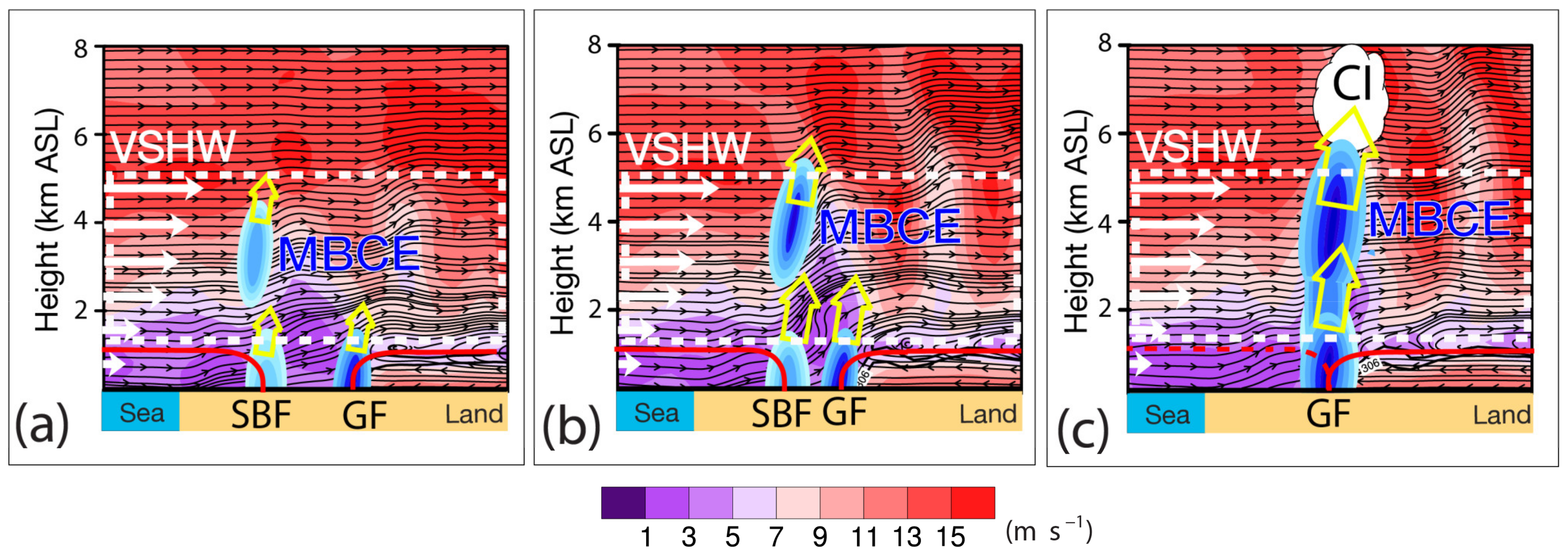
The vertical cross section of the horizontal divergence, horizontal wind velocity (HWV), and the locations of the air parcels revealed that there was a weak-wind region in the intermediate region of the immature SBF and GF, and a high-wind region in the near-upstream area of the weak-wind region. It is noteworthy that the northeastern half part of the SBF, which was mainly merged with the GF, revealed an immature state showing a weak and quasi-stationary convergent leading edge without any rotor circulation and front-to-rear return flow. During the merger process, the weak-wind region was squeezed and elevated to the mid-level (i.e., 3–6 km AGL), while the HWV in the high-wind region was intensified gradually. Consequently, a blocking (or deceleration) effect was formed in the mid-level between the high-wind region and weak-wind region, and caused a significant convergence in the mid-level, which was called mid-level blocking convergence effect (MBCE) in the present study. Moreover, there was a lower convergence region developed owing to the squeezing and (or) merging of the convergent leading edges of the SBF and GF. Although the immature SBF had rather weak convergent leading edge without any rotor circulation and front-to-rear return flow, it still played an important role for the formation of these two convergence regions. These two convergences were responsible for the extension term which played a positive contribution to the . As summarized in a schematic model in Figure 16, the MBCE and VSHW are considered as the important dynamic force during the merger processes of the SBF and the GF in the present study.
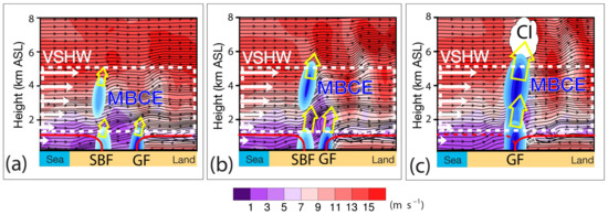
Figure 16.
Schematic model summarizing CI mechanism affected by the mid-level blocking convergence effect (MBCE) and vertical shear of the horizontal wind (VSHW), which are considered the important dynamic force associated with the merger of the sea-breeze front (SBF) and the gust front (GF) investigated in the present study. (a–c) indicate the different status of the merger process. The background shading indicates the horizontal wind velocity (unit: m s−1). The blue-filled ellipses denote the convergence (including the convergent leading edges of the SBF and GF, as well as the mid-level convergence due to the MBCE). The white arrows indicate the horizontal wind velocity, and the dashed white box indicates the area where there are high VSHW which is responsible for the vertical twisting. The hollow arrows in yellow indicate the updraft induced by the convergence below.
The vertical cross section of the potential temperature anomaly and hydrometeors along the same line segment indicated the release of latent heat resulted in the warming of the surrounding environment of the air parcels, which was responsible for the . It is similar to the warming due to the release of latent heat which dominated the during a CI case which occurred in southwestern Xinjiang, Northwest China, reported by Abulikemu et al. [4]. In their case, the buoyant acceleration in the slow lifting period was caused by the warm advection generated by the radiative heating near the mountainous area on the south side of the Tarim Basin. Moreover, the extension term played a negative role on during the last ~10 min rapid lifting period. Along with the typical convective cells selected, similar analysis of vertical momentum budgets were also conducted for two other convective cells initiated due to the merger of the immature SBF and the GF which showed the same conclusion for the CI mechanism (please see the Supplementary Materials Figures S1–S3, which can be downloaded from the URL mentioned at the end of this paper).
It is interesting that the merger processes of the immature SBF and GF still induced many CIs in the merging area. The immaturity of the SBF was reflected in the structures or circulations of the northeastern SBF, (e.g., absence of the vertical rotor circulations following closely to the leading edge of the SBF, the Kelvin-Helmholtz Billows (KHBs) behind the head of the SBF, and front-to-rear return flow aloft). To the authors’ knowledge, there was no previous study reporting the CI mechanism associated with the merger of an immature SBF and a GF. Moreover, the MBCE during the merger of the SBF and GF is proposed for the first time in this present study. Therefore, it is believed that the findings obtained in our present study are unique, and it can provide some new perspectives about the CI mechanism associated with the merger of an immature SBF and GF. However, given that this is only a case study, as well as the significant complexity of the CI process, more studies are still needed. There could also be other factors at work such as HCRs [59,60,61] and gravity waves [62,63], which will be studied in the future.
Supplementary Materials
The following supporting information can be downloaded at: https://www.mdpi.com/article/10.3390/atmos13050750/s1. Figures S1–S3, see the Supplementary Materials.
Author Contributions
Data curation: J.Z.; Formal analysis: J.Z. and A.A.; Investigation: J.Z., A.A., and M.K.; Methodology: A.A.; Project administration: A.A.; Resources: Y.W. and Y.L.; Software: J.Z., A.A., and M.K.; Supervision: A.A.; Validation: J.Z. and A.A.; Writing—original draft: J.Z. and A.A.; Writing—review and editing: J.Z. and A.A. All authors have read and agreed to the published version of the manuscript.
Funding
This work was supported by the National Natural Science Fund of China (41705032), National Key R&D Program of China (2018YFC1507103), Doctoral Research Startup Foundation of Xinjiang University (50500/62031224618), and 100 Young Doctors Introduction Program of Xinjiang (Tianchi Doctor Program) Foundation (50500/04231200737).
Institutional Review Board Statement
Not applicable.
Informed Consent Statement
Not applicable.
Data Availability Statement
The observation data (including Radar observation data, automatic weather station data and Skew T-logP data) and WRF simulation output data employed in present research are available at https://figshare.com/s/dd6e301acbe5fae30e53, Besides, the NCEP FNL data can be downloaded from this website https://rda.ucar.edu/datasets/ds083.2 (accessed on 25 February 2022).
Acknowledgments
We thank the anonymous reviewers and editor for their valuable comments and suggestions. We also thank the High Performance Computing Center of Nanjing University, Nanjing, Jiangsu Province, China, for doing the numerical calculations in this paper on its IBM Blade cluster system.
Conflicts of Interest
The authors declare no conflict of interest.
References
- Lock, N.A.; Houston, A.L. Empirical examination of the factors regulating thunderstorm initiation. Mon. Weather Rev. 2014, 142, 240–258. [Google Scholar] [CrossRef]
- Ukkonen, P.; Manzato, A.; Makela, A. Evaluation of thunderstorm predictors for Finland using reanalyses and neural networks. J. Appl. Meteorol. Climatol. 2017, 56, 2335–2352. [Google Scholar] [CrossRef]
- Du, Y.; Chen, G. Heavy rainfall associated with double low-level jets over Southern China. Part II: Convection initiation. Mon. Weather Rev. 2019, 147, 543–565. [Google Scholar] [CrossRef]
- Abulikemu, A.; Ming, J.; Xu, X.; Zhuge, X.; Wang, Y.; Zhang, Y.; Zhang, S.; Yu, B.; Aireti, M. Mechanisms of Convection Initiation in the Southwestern Xinjiang, Northwest China: A Case Study. Atmosphere 2020, 11, 1335. [Google Scholar] [CrossRef]
- Lin, G.; Grasmick, C.; Geerts, B.; Wang, Z.; Deng, M. Convection initiation and bore formation following the collision of mesoscale boundaries over a developing stable boundary layer: A case study from PECAN. Mont. Weather Rev. 2021, 149, 2351–2367. [Google Scholar] [CrossRef]
- Kong, M.; Abulikemu, A.; Zheng, J.; Aireti, M.; An, D. A Case Study on Convection Initiation Associated with Horizontal Convective Rolls over Ili River Valley in Xinjiang, Northwest China. Water 2022, 14, 1017. [Google Scholar] [CrossRef]
- Markowski, P.; Convective Storm Initiation and Organization. Atmospheric Convection: Research and Operational Forecasting Aspects; CISM International Centre for Mechanical Sciences, 475; Giaiotti, D.B., Steinacker, R., Stel, F., Eds.; Springer: Vienna, Austria, 2007. [Google Scholar] [CrossRef]
- Wilhelmson, R.B.; Chen, C.S. A simulation of the development of successive cells along a cold outflow boundary. J. Atmos. Sci. 1982, 39, 1466–1483. [Google Scholar] [CrossRef]
- Wilson, J.W.; Schreiber, W.E. Initiation of convective storms at radar-observed boundary-layer convergence lines. Mon. Weather Rev. 1986, 114, 2516–2536. [Google Scholar] [CrossRef]
- Harrison, S.J.; Mecikalski, J.R.; Knupp, K.R. Analysis of outflow boundary collisions in North-Central Alabama. Weather Forecast 2009, 24, 1680–1690. [Google Scholar] [CrossRef]
- Lompar, M.; Curic, M.; Romanic, D. Implementation of a gust front head collapse scheme in the WRF numerical model. Atmos. Res. 2018, 203, 231–245. [Google Scholar] [CrossRef]
- Grasmick, C.; Geerts, B.; Turner, D.D.; Wang, Z.; Weckwerth, T.M. The Relation between Nocturnal MCS Evolution and Its Outflow Boundaries in the Stable Boundary Layer: An Observational Study of the 15 July 2015 MCS in PECAN. Mon. Weather Rev. 2018, 146, 3203–3226. [Google Scholar] [CrossRef]
- Bai, L.; Meng, Z.; Huang, Y.; Zhang, Y.; Niu, S.; Su, T. Convection Initiation Resulting From the Interaction Between a Quasi-Stationary Dryline and Intersecting Gust Fronts: A Case Study. J. Geophys. Res. Atmos. 2019, 124, 2379–2396. [Google Scholar] [CrossRef]
- Abulikemu, A.; Wang, Y.; Gao, R.; Wang, Y.; Xu, X. A numerical study of convection initiation associated with a gust front in Bohai Bay region, North China. J. Geophys. Res. Atmos. 2019, 124, 843–860. [Google Scholar] [CrossRef]
- Hirt, M.; Craig, G.C.; Schäfer, S.A.K.; Savre, J.; Heinze, R. Cold-pool-driven convective initiation: Using causal graph analysis to determine what convection-permitting models are missing. Q. J. R. Meteorol. Soc. 2020, 146, 2205–2227. [Google Scholar] [CrossRef]
- Simpson, J.E. Sea Breeze and Local Wind; Cambridge University Press: Cambridge, UK, 1994; p. 234. [Google Scholar]
- Xian, Z.J.; Pielke, R.A. The Effects of Width of Landmasses on the Development of Sea Breezes. J. Appl. Meteorol. 1991, 30, 1280–1304. [Google Scholar] [CrossRef]
- Lee, O.; Shun, C.M. Observation of sea breeze interactions at and near Hong Kong International Airport. Meteorol. Appl. 2003, 10, 1–9. [Google Scholar] [CrossRef]
- Birch, C.E.; Roberts, M.J.; Garcia-Carreras, L.; Ackerley, D.; Reeder, M.J.; Lock, A.P.; Schiemann, R. Sea-Breeze Dynamics and Convection Initiation: The Influence of Convective Parameterization in Weather and Climate Model Biases. J. Clim. 2015, 28, 8093–8108. [Google Scholar] [CrossRef]
- Wu, F.; Lombardo, K. Precipitation Enhancement in Squall Lines Moving Over Mountainous Coastal Regions. J. Atmos. Sci. 2021, 78, 3089–3113. [Google Scholar] [CrossRef]
- Bergemann, M.; Jakob, C.; Lane, T.P. 2015: Global detection and analysis of coastline-associated rainfall using an objective pattern recognition technique. J. Clim. 2015, 28, 7225–7236. [Google Scholar] [CrossRef]
- Plant, R.S.; Keith, G.J. Occurrence of Kelvin-Helmholtz Billows in Sea-breeze Circulations. Bound.-Layer Meteorol. 2007, 122, 1–15. [Google Scholar] [CrossRef]
- Browand, F.K.; Troutt, T.R. A note on spanwise structure in the two-dimensional mixing layer. J. Fluid Mech. 1980, 97, 771–781. [Google Scholar] [CrossRef]
- Lasheras, J.C.; Choi, H. Three-dimensional instability of a plane free shear layer: An experimental study of the formation and evolution of streamwise vortices. J. Fluid Mech. 1988, 189, 53–86. [Google Scholar] [CrossRef]
- Schowalter, D.G.; Van Van Atta, C.W.; Lasheras, J.C. A study of streamwise vortex structure in a stratified shear layer. J. Fluid Mech. 1994, 281, 247–291. [Google Scholar] [CrossRef]
- Simpson, J.E. Gravity Currents in the Environment and the Laboratory; Cambridge University Press: New York, NY, USA, 1997; p. 244. [Google Scholar]
- Buckley, R.L.; Kurzeja, R.J. An Observational and Numerical Study of the Nocturnal Sea Breeze. Part I: Structure and Circulation. J. Appl. Meteorol. 1997, 36, 1577–1598. [Google Scholar] [CrossRef]
- Miller, S.; Keim, B.; Talbot, R.; Mao, H. Sea breeze: Structure, forecasting, and impacts. Rev. Geophys. 2003, 41, 1011. [Google Scholar] [CrossRef]
- Crosman, E.T.; Horel, J.D. Sea and lake breezes: A review of numerical studies. Bound.-Layer Meteorol. 2010, 137, 1–29. [Google Scholar] [CrossRef]
- Chen, G.; Iwai, H.; Ishii, S.; Saito, K.; Seko, H.; Sha, W.; Iwasaki, T. Structures of the sea-breeze front in dual-Doppler lidar observation and coupled mesoscale-to-LES modeling. J. Geophys. Res. Atmos. 2019, 124, 2397–2413. [Google Scholar] [CrossRef]
- Purdom, J.F.W.; Marcus, K. Thunderstorm trigger mechanisms over the southeast U.S. preprints. In Proceedings of the 12th Conference on Severe Local Storms, San Antonio, TX, USA, 12–15 January 1982; pp. 487–488. [Google Scholar]
- Nicholls, M.E.; Pielke, R.A.; Cotton, W.R. A Two-Dimensional Numerical Investigation of the interaction between Sea Breezes and Deep Convection over the Florida Peninsula. Mon. Weather Rev. 1991, 119, 298–323. [Google Scholar] [CrossRef][Green Version]
- Fankhauser, J.C.; Crook, N.A.; Tuttle, J.; Miller, L.J.; Wade, C.G. Initiation of Deep Convection Along Boundary-Layer Convergence Lines in a Semitropical Environment. Mon. Weather Rev. 1995, 123, 291–313. [Google Scholar] [CrossRef]
- Kingsmill, D.E.; Crook, N.A. An observational study of atmospheric bore formation from colliding density currents. Mon. Weather Rev. 2003, 131, 2985–3002. [Google Scholar] [CrossRef]
- Carbone, R.E.; Wilson, J.W.; Keenan, T.D.; Hacker, J.M. Tropical island convection in the absence of significant topography. Part I: Life cycle of diurnally forced convection. Mon. Weather Rev. 2000, 128, 3459–3480. [Google Scholar] [CrossRef]
- Kingsmill, D.E. Convection Initiation Associated with a Sea-Breeze Front, a Gust Front, and Their Collision. Mon. Weather Rev. 1995, 123, 2913–2933. [Google Scholar] [CrossRef]
- Abulikemu, A.; Xu, X.; Wang, Y.; Ding, J.; Wang, Y. Atypical Occlusion Process Caused by the Merger of a Sea-breeze Front and Gust Front. Adv. Atmos. Sci. 2015, 32, 1431–1443. [Google Scholar] [CrossRef]
- Abulikemu, A.; Xu, X.; Wang, Y.; Ding, J.; Zhang, S.; Shen, W. A modeling study of convection initiation prior to the merger of a sea-breeze front and a gust front. Atmos. Res. 2016, 182, 10–19. [Google Scholar] [CrossRef]
- Mahoney, W.P. Gust front characteristics and the kinematics associated with interacting thunderstorm outflows. Mon. Weather Rev. 1988, 116, 1474–1491. [Google Scholar] [CrossRef]
- Weckwerth, T.M.; Parsons, D.B. A review of convection initiation and motivation for IHOP_2002. Mon. Weather Rev. 2006, 134, 5–22. [Google Scholar] [CrossRef]
- Schultz, D.M. Review of cold fronts with prefrontal troughs and wind shifts. Mon. Weather Rev. 2005, 133, 2449–2472. [Google Scholar] [CrossRef]
- Rotunno, R.; Klemp, J.B.; Weisman, M.L. A theory for strong, long-lived squall lines. J. Atmos. Sci. 1988, 46, 463–485. [Google Scholar] [CrossRef]
- Skamarock, W.C.; Klemp, J.B.; Dudhia, J.; Gill, D.O.; Liu, Z.; Berner, J.; Wang, W.; Powers, J.G.; Duda, M.G.; Barker, D.M.; et al. A Description of the Advanced Research WRF Model Version 4.1 (No. NCAR/TN-556+STR); National Center for Atmospheric Research: Boulder, CO, USA, 2019. [Google Scholar] [CrossRef]
- Xu, X.; Xue, M.; Wang, Y. The genesis of mesovortices within a real-data simulation of a bow echo system. J. Atmos. Sci. 2015, 72, 1963–1986. [Google Scholar] [CrossRef]
- Lim, K.-S.S.; Hong, S.-Y. Development of an effective double-moment cloud microphysics scheme with prognostic cloud condensation nuclei (CCN) for weather and climate models. Mon. Weather Rev. 2010, 138, 1587–1612. [Google Scholar] [CrossRef]
- Hong, S.Y.; Lim, J.O. The WRF single-moment 6-class microphysics scheme (WSM6). J. Korean Meteorol. Soc. 2006, 42, 129–151. Available online: https://www2.mmm.ucar.edu/wrf/users/workshops/WS2006/abstracts/PSession05/P5_4_Hong.pdf (accessed on 5 April 2020).
- Dudhia, J. Numerical study of convection observed during the winter monsoon experiment using a mesoscale two-dimensional model. J. Atmos. Sci. 1989, 46, 3077–3107. [Google Scholar] [CrossRef]
- Mlawer, E.J.; Taubman, S.J.; Brown, P.D.; Iacono, M.J.; Clough, S.A. Radiative transfer for inhomogeneous atmospheres:RRTM, a validated correlated-k model for the longwave. J. Geophys. Res. Atmos. 1997, 102, 16663–16682. [Google Scholar] [CrossRef]
- Tewari, M.; Chen, F.; Wang, W.; Dudhia, J.; LeMone, M.A.; Mitchell, K.; Ek, M.; Gayno, G.; Wegiel, J.; Cuenca, R.H. Implementation and verification of the unified NOAH land surface model in the WRF model. In Proceedings of the 20th Conference on Weather Analysis and Forecasting/16th Conference on Numerical Weather Prediction, Seattle, WA, USA, 12–16 January 2004; Available online: https://ams.confex.com/ams/84Annual/techprogram/paper_69061.htm. (accessed on 5 April 2020).
- Kain, J.S. The Kain–Fritsch convective parameterization: An update. J. Appl. Meteorol. 2004, 43, 170–181. [Google Scholar] [CrossRef]
- Xu, X.; Xue, M.; Wang, Y.; Huang, H. Mechanisms of secondary convection within a Mei-Yu frontal mesoscale convective system in eastern China. J. Geophys. Res. Atmos. 2017, 122, 47–64. [Google Scholar] [CrossRef]
- Jeevanjee, N.; Romps, D.M. Effective buoyancy, inertial pressure, and the mechanical generation of boundary layer mass flux by cold pools. J. Atmos. Sci. 2015, 72, 3199–3213. [Google Scholar] [CrossRef][Green Version]
- Davies-Jones, R. An expression for effective buoyancy in surroundings with horizontal density gradients. J. Atmos. Sci. 2003, 60, 2922–2925. [Google Scholar] [CrossRef]
- Torri, G.; Kuang, Z.M.; Tian, Y. Mechanisms for convection triggering by cold pools. Geophys. Res. Lett. 2015, 42, 1943–1950. [Google Scholar] [CrossRef]
- Adams, J.C. MUDPACK: Multigrid portable Fortran software for the efficient solution of linear elliptic partial differential equations. Appl. Math. Comput. 1989, 34, 113–146. [Google Scholar] [CrossRef]
- Schenkman, A.D.; Xue, M.; Dawson, D.T., II. The cause of internal outflow surges in a high-resolution simulation of the 8 May 2003 Oklahoma City tornadic supercell. J. Atmos. Sci. 2016, 73, 353–370. [Google Scholar] [CrossRef]
- Dawson, D.T.; Xue, M.; Shapiro, A.; Milbrandt, J.A.; Schenkman, A.D. Sensitivity of real-data simulations of the 3 May 1999 Oklahoma City tornadic supercell and associated tornadoes to multimoment microphysics. Part II: Analysis of buoyancy and dynamic pressure forces in simulated tornado-like vortices. J. Atmos. Sci. 2016, 73, 1039–1061. [Google Scholar] [CrossRef]
- Klemp, J.B.; Rotunno, R. A study of the tornadic region within a supercell thunderstorm. J. Atmos. Sci. 1983, 40, 359–377. [Google Scholar] [CrossRef]
- Wakimoto, R.M.; Atkins, N.T. Observations of the sea-breeze front during Cape. 1. Single-Doppler, satellite, and cloud photogrammetry analysis. Mon. Weather Rev. 1994, 122, 1092–1114. [Google Scholar] [CrossRef]
- Dailey, P.S.; Fovell, R.G. Numerical simulation of the interaction between the sea-breeze front and horizontal convective rolls.Part I: Offshore ambient flow. Mon. Weather Rev. 1999, 127, 858–878. [Google Scholar] [CrossRef]
- Fovell, R.G.; Dailey, P.S. Numerical simulation of the interaction between the sea-breeze front and horizontal convective rolls.Part II: Alongshore ambient flow. Mon. Weather Rev. 2001, 129, 2057–2072. [Google Scholar] [CrossRef]
- Fovell, R.G. Upstream influence of numerically simulated squall-line storms. Q. J. R. Meteorol. Soc. 2002, 128, 893–912. [Google Scholar] [CrossRef]
- Fovell, R.G.; Mullendore, G.L.; Kim, S.H. Discrete propagation in numerically simulated nocturnal squall lines. Mon. Weather Rev. 2006, 134, 3735–3752. [Google Scholar] [CrossRef]
Publisher’s Note: MDPI stays neutral with regard to jurisdictional claims in published maps and institutional affiliations. |
© 2022 by the authors. Licensee MDPI, Basel, Switzerland. This article is an open access article distributed under the terms and conditions of the Creative Commons Attribution (CC BY) license (https://creativecommons.org/licenses/by/4.0/).

