Abstract
The paper analyzes the influence of atmospheric circulation on cloudiness and cloud types during July and August of 2016 in Petuniabukta and Svalbard-Lufthavn. For the meteorological parameters, basic statistical measures were calculated and the average diurnal cloud patterns were analyzed. Taking the data from meteorological reanalysis (NCEP/NCAR-The National Centers for Atmospheric Prediction/The National Center for Atmospheric Research) regarding the mean sea-level pressure (SLP), 500 hPa geopotential height, and air temperature at 850 hPa (T850), composite maps of the synoptic situation for the studied area were constructed. For the observed types of clouds, the frequency of their occurrence in particular types of atmospheric circulation was then determined according to the Niedźwiedź classification. Differences in the amount of cloudiness in the examined measuring points were ascertained. The occurrence of cloud types is associated with both the direction of air mass advection and type of circulation. The results may also indicate the possibility of influence from specific, local environmental features on cloudiness.
1. Introduction
Clouds contribute to the environment through a variety of physical processes, playing a significant role over many spatial scales, and providing both liquid and solid forms of precipitation. Moreover, clouds are the principal modulator of the global climate system through their role in maintaining the Earth’s radiation balance [1]. On the one hand, they reflect a high amount of incoming solar radiation and thus reduce the radiation absorbed by the ground surface, not to mention modifying the outcoming long wave radiation. On the other hand, cloud cover, along with its size and type, depends on many meteorological factors, changes in which belong to factors that also determine climate change according to the IPCC 2007 report [2].
Cloudiness is one of the most important meteorological elements that reflect the state of the atmosphere, and is largely shaped by the influence of circulation factors [3]. It has been the subject of observation for many decades, which allowed for the study of long-term changes in cloudiness in relation to atmospheric circulation and synoptic weather patterns in particular. Research into cloudiness in the polar regions, an issue affected by some very serious climate changes, is of great importance to the understanding of climate processes on a global scale [4]. That makes it crucial to obtain up-to-date (further) information on the spatial and temporal variation of cloudiness and atmospheric circulation at high latitudes—in places such as Svalbard.
The Svalbard archipelago has been the subject of many studies dealing with the macrophysical and microphysical properties of clouds e.g., [5,6,7,8,9,10]. The investigations concentrated mainly on research centers and meteorological stations with extensive instrumentation, i.e., Ny-Alesund, Hornsund, and Longyearbyen located on Spitsbergen—the largest island in the Svalbard archipelago. A comprehensive study of Spitsbergen’s cloudiness based on observations at the Polish Polar Station in Hornsund was conducted by [11,12]. As of today, the occurrence of cloudiness and its effect on radiation balance or individual meteorological elements have been examined during several summer experiments [13,14,15,16]. In the research area of Petuniabukta in central Spitsbergen, the amount and types of cloud were examined by [17,18]. However, only a few studies have dealt with the influence of atmospheric circulation on cloudiness and cloud types [3,19,20,21]. These concern mostly the influence of atmospheric circulation in relation to cloud observation recorded at the Svalbard-Lufthavn meteorological station. In our investigation, the impact of atmospheric circulation extends to the weather conditions in Petuniabukta.
Therefore, the main objective of this study is to determine the relationship between synoptic situations and cloud properties (cloud amount and type) at two meteorological stations located in central Spitsbergen. This work will include a comparison of ground-based observations recorded at the Svalbard-Lufthavn station in Longyearbyen airport and the Adam Mickiewicz University Polar Station in Petuniabukta during the summer of 2016.
So far, no studies on cloud cover in the central part of Spitsbergen based on observations carried out at the Adam Mickiewicz University station in Petuniabukta have been conducted despite many years of research on other meteorological elements. It should be noted that observations conducted on the type and size of cloud cover, carried out in the summer of 2016 in Petuniabukta, required a lot of involvement on the part of research participants. The comparison of the obtained observation results with the data on cloud cover in Svalbard Lufthavn, located in other local conditions (with openness to undisturbed advection of air masses from the west), makes it possible to indicate possible differences in cloud cover in the central part of Spitsbergen.
Study Area
The research area is located in central Spitsbergen (Figure 1). The Svalbard-Lufthavn meteorological station is located near the Longyearbyen airport (ICAO code: ENSB, No. WMO 01008) at 27 m a.s.l. (geographical coordinates of the point: 78°15′ N, 15°28′ E). This station is directly impacted by the air masses flowing from the direction of the Greenland Sea. The second station is located 54 km in a straight line to the northeast towards the Billefjord in Petuniabukta on the western shore of the fiord. The observation point is located approximately 10 m from the shoreline (coordinates of the point: 78°41′ N 16°27′ E) at an altitude of 5 m above sea level near the Polar Station of Adam Mickiewicz University (Poznań, Poland). In the neighbourhood of the point, there are rock massifs raised to an average height of 600–800 m a.s.l., with the highest top close to the Pyramiden (937 m a.s.l.). From the east, the flow of air is hindered by the arrangement of mountain ridges with heights of 600–700 m a.s.l. Situated at the eastern fiord shore, Ebbadalen also affects local atmospheric conditions in the vicinity of the Adam Mickiewicz University Polar Station [17]. The southern sector of the station’s surroundings is characterized by a lack of orographic barriers, which determines the free flow of air from this direction [22].
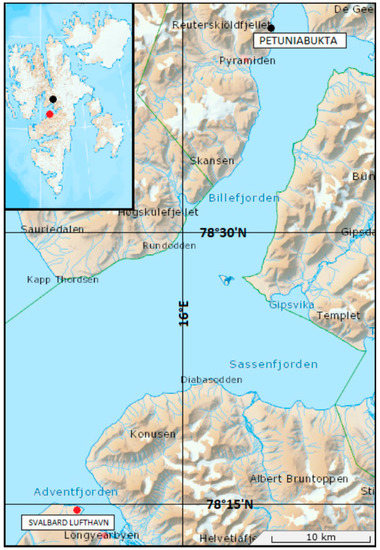
Figure 1.
Location of research area including meteorological stations at Svalbard—Lufthavn and Petuniabukta. Based on: http://toposvalbard.npolar.no/ accessed on 10 May 2021.
2. Materials and Methods
This research is based on observational data from two measurement points: Petuniabukta and Longyearbyen (Svalbard-Lufthavn). In Petuniabukta, observations of cloudiness (amount and type) in the summer of 2016 were carried out. Having taken the obtained data on cloud groups into consideration, a database according to the WMO SYNOP Data Format (FM-12) was prepared. Measurements in Petuniabukta were conducted by one observer every 3 h in the period from 9 July to 30 August 2016 during a summer polar expedition. Equivalent data for the Svalbard-Lufthavn were obtained from the SYNOP meteorological reports (website: ogimet.com accessed on 15 September 2020).
In the first part of this study, a comparison of the reported cloud types in Petuniabukta and Svalbard-Lufthavn, as well as the differences and similarities (in particular, the key numbers in the FM-12 SYNOP message), were determined (Table 1).

Table 1.
Clouds according to SYNOP report. Level of clouds: CL—low, CM—medium, CH—high.
In the second part of the study, a comparison of the cloud amount and frequency of individual types and species of clouds in both stations was made. Next, the frequency of cloud types occurrence, in particular the circulation types according to the [23] types of circulation, was determined. The types of atmospheric circulation were established on the basis of the direction and type of air mass advection, i.e., synoptic situations were divided into cyclonic, anticyclonic, and unclassifiable. Detailed information on particular types are provided in Table 2.

Table 2.
Types of atmospheric circulation by Niedźwiedź [23].
Then, taking into account the average daily cloudiness, the days with extreme values (assuming the threshold values of the 5th and 95th percentiles of the cloud amount in the examined period in both stations) were distinguished [2]. In accordance with the adopted criteria, the extremely small cloudiness mean value was below 3 oktas and extremely large above values of 8 oktas.
For Svalbard-Lufthavn, an extremely small level of cloudiness occurred on 9, 10, and 27 July 2016. In turn, an extremely large cloud cover was recorded on 20 July and 17 August 2016. For Petuniabukta, extremely small cloudiness occurred on the same days as in Svalbard-Lufthavn, while an extremely large cloud cover appeared on 22 and 23 July and on 7, 19, and 20 August 2016.
Next, based on the NCEP/NCAR reanalysis data [24] for the daily sea-level pressure (SLP), 500 hPa geopotential height (z500), and air temperature at 850 hPa geopotential height (T850), composite maps of the synoptic situations and their anomalies for the 30 W–60 E, 70 N–85 N for the period 1948–2016, as well as for distinguished days with extreme cloudiness were created. The anomalies were calculated by subtracting values (SLP, T850, and z500) from the chosen days’ mean values (1948–2016). Then, for days with the above-mentioned extreme cloudiness, their daily courses of cloudiness, basic statistics, and differences between measurement points were calculated.
3. Results
On the basis of the information contained in the SYNOP meteorological reports from Svalbard-Lufthavn, a comparison of the level of cloudiness with the observations carried out in Petuniabukta was made. The average cloud cover in the period of research for Svalbard-Lufthavn was 6.0 oktas, while for Petuniabukta it was 6.6 oktas.
In Petuniabukta, 70% of the study days had a cloudiness rate of over 7, and then again over 7 on 80% of days in which the range of cloud cover was from 6 to 8. Similarly, for Svalbard Lufthavn on over 70% of study days, cloudiness was equal to or greater than 7, and on almost 80% of days it was equal to or greater than 6. The biggest difference between the stations concerned the state of total cloudiness, which occurred most frequently in Petuniabukta (43% of days) and only rarely in Svalbard-Lufthavn (only on 8% of study days) (Figure 2). The course of cloudiness in both stations shows a similarity in the studied period. In the early days of measurements around 29 July, there was a lack of cloud cover, which was related to the advection of warm air mass from the south. The next episodes with less cloudiness appeared around 8 August and 26 August, which was also caused by circulatory conditions. The daily total cloudiness (8 oktas) shows a much larger proportion of cases in Petuniabukta than in Svalbard-Lufthavn (Figure 3). In most cases, the differences in cloudiness between stations do not exceed 1 okta. In turn, the greatest differences in total cloudiness (four or more oktas) occurred only a dozen times in the studied period (Figure 3C).
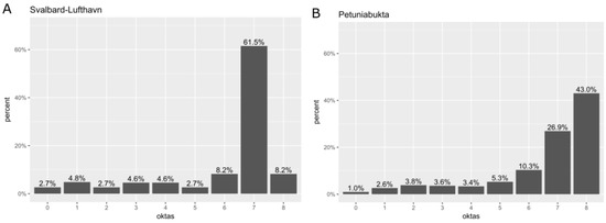
Figure 2.
The frequency of cloudiness in Svalbard-Lufthavn (A) and Petuniabukta (B) during the period from 9 July to 30 August 2016.
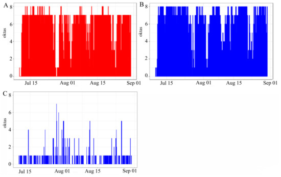
Figure 3.
The daily amount of cloudiness in Longyearbyen (Svalbard-Lufthavn) (A) and Petuniabukta (B) and the difference between Petuniabukta and Svalbard-Lufthavn (C) during the period from 9 July to 30 August 2016.
The frequency levels of clouds divided into groups according to the SYNOP code are presented in Table 3. In the analyzed stations, differences in the number of reported types of clouds can be noticed. In Petuniabukta, Stratus nebulosus (St neb) (SYNOP CL6 key) was more often observed than in Svalbard-Lufthavn. In turn, a lower frequency of Stratocumulus (Sc) clouds (SYNOP CL5 key) was observed in Petuniabukta. Noteworthy is also the reports of lower amounts of medium cloud level in Petuniabukta. However, it could have resulted from the Stratus total cloud cover often covering the sky, which prevented the observation of clouds at higher altitudes. The differences observed may be due to local conditions because Petuniabukta is surrounded by relatively high mountain massifs and is located in the middle of the island, which favors the creation of Stratus cloud cover [25].

Table 3.
Percentage of cloud types in Petuniabukta and Svalbard-Lufthavn during the period from 9 July to 30 August 2016. Level of clouds: CL—low, CM—medium, CH—high.
The next stage of the study was to determine the average daily cloudiness in individual types of circulation according to [23] air circulation types. Detailed information of the aforementioned classification is included in Table 4. In the discussed period, circulation types SEa, Sa, NWa, SEc, and Sc were not observed. In the analyzed stations, similar values of average cloud cover can be noticed in any given type of circulation. The lowest cloudiness occurred in the Ea and NEa circulation types, while the highest occurred in the SWa, Ec, SWc, Cc, and Bc types. In Petuniabukta, the types of circulation with a total average daytime cloudiness equaling 8 can be distinguished. These are the SWa, SWc, NWc, and Cc types.

Table 4.
Mean daily cloudiness (in oktas) in particular atmospheric circulation types by [23] in Svalbard-Lufthavn and Petuniabukta during the period from 9 July to 30 August 2016.
The relative frequency of cloud types in the atmospheric circulation types in accordance with [23] is presented in Table 5. In the anticyclonic types of air circulation, low-level clouds (Cu, Sc, and St) were most frequently observed in the following types: NEa, SWa, Wa, Na, Ka, and Ca; medium level (As and Ac): Ea and Wa; high-level clouds (Ci, Cs, and Cc): NEa. In the cyclonic types of air circulation, low-level clouds (Cu, Sc, and St) were most frequently observed in the following types: Nc, NEc, Ec, SWc, Wc, NWc, Cc, and Bc; middle level (As and Ac): Ec and NWc; high level (Ci, Cs, and Cc): Nc and NEc. The measurement points show variations in the stratocumulus and stratus clouds’ appearance. In Svalbard Lufthavn, stratocumulus is observed more frequently in cyclonic circulation types. Stratus clouds are observed more frequently in Petuniabukta, and these occur in all types of circulation. Cloudiness of medium and high levels at the Petuniabukta point is not often observed because layered clouds, fully covering the sky, dominate here (cloud cover through clouds of a lower level).

Table 5.
The relative frequency (%) of occurrence of cloud types in atmospheric circulation types according to [23] in Svalbard-Lufthavn and Petuniabukta during the period from 9 July to 30 August 2016.
3.1. Synoptic Conditions during the Study Period
A mean daily sea-level pressure (SLP), geopotential height of 500 hPa (z500), and air temperature at an altitude of 850 hPa (T850) around the Svalbard archipelago during July and August of 2016 are shown in the left column of Figure 4. SLP values are characterized by a small variation from 1010.5 hPa in the north to over 1012 hPa in the southeast of the investigated area. The altitudinal values of the 500 hPa geopotential height are changed from 5460 m above sea level in the northern part of the investigated area to 5560 m above sea level in the south-eastern part. Since the temperature distribution at 850 hPa is similar to the SLP pattern (increasing from north to south from −0.5 °C to more than 2.5 °C accordingly), we can conclude that there is a clear zonal distribution of air masses around the investigated area. The values of the SLP, z500, and T850 for the period July–August 2016, in relation to mean values from the multiannual period as anomalies, are presented in the right-hand column of Figure 4. In the Svalbard area during the investigated period, anomalies of SLP and z500 pointed to lower values than average, reaching respectively 2.5 hPa and 20 m; meanwhile, the T850 values were similar to the multiannual mean.
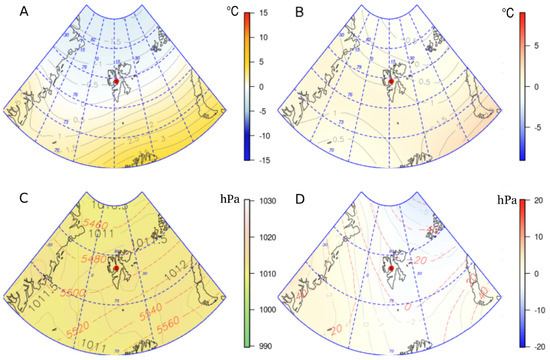
Figure 4.
The average air temperature at an altitude of 850 hPa (T850) (°C)—grey solid line (A) and its anomalies (B) and the daily sea-level pressure distribution (SLP) (hPa)—grey solid line and geopotential height of 500 hPa (m)—red dotted line (C) and its anomalies (D) for the July–August 2016 period. The maps of anomalies (B,D) were calculated on the basis of mean values for the climatological period 1948–2016. The red point shows the research area.
3.2. Synoptic Conditions on Days with Small Cloudiness
The synoptic pattern and mass advection clearly affected conditions of cloudiness. On days when the examined area was affected by high-pressure or on the edge of a high-pressure system, a small cloudiness was observed. Bearing in mind the calendar of the [23] circulation types, during these days the following types occurred: Ea (9 July 2016), NEa (10 July 2016), and Ka (27 July 2016).
On 10 July, the temperature at an altitude of 850 hPa was higher than the mean value by approximately 3 °C, while the level of 500 hPa geopotential was higher by 150 m than the mean. On the remaining days with weather type analyzed, the thermal conditions at an altitude of 850 hPa were slightly cooler than the mean values, while the location of the 500 hPa geopotential was slightly higher than the mean value. Very similar synoptic conditions were observed on the 9th and 10th of July. In turn, on the 27 July, the Svalbard archipelago was under the direct influence of a high-pressure system with pressure at sea level of over 1022 hPa. On that day, the sea-level pressure was about 10 hPa higher than average conditions. The 10th and 27th of July were chosen as examples presented in Figure 5 and Figure 6.
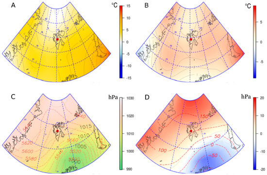
Figure 5.
Air temperature at an altitude of 850 hPa (T850) (°C)—grey solid line (A) and its anomalies (B) and the daily sea-level pressure distribution (SLP) (hPa)—grey solid line and geopotential height of 500 hPa (m)—red dotted line (C) and its anomalies (D) for 10 July 2016. The red point shows the research area.
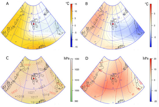
Figure 6.
Air temperature at an altitude of 850 hPa (T850) (°C)—grey solid line (A) and its anomalies (B) and the average daily sea-level pressure distribution (SLP) (hPa)—grey solid line and geopotential height of 500 hPa (m)—red dotted line (C) and its anomalies (D) for 27 July 2016. The red point shows the research area.
3.3. Synoptic Conditions on Days with Considerable Cloudiness
On days with cloudy and windy weather, the area under examination was directly affected by a low-pressure system (20 July 2016 and 7 August 2016), a low-pressure trough (17 August 2016, 19 August 2016, 20 August 2016), and on the northern or north-western wedge by a high-pressure system (23 July 2016). According to the calendar of the Niedźwiedź circulation types, on these days types Cc, Cc, SWc, SWc, SWc, and SWa occurred consecutively [23]. Composite maps of the synoptic situation on the chosen days (the bold dates above) were presented consecutively as examples in Figure 7, Figure 8 and Figure 9.
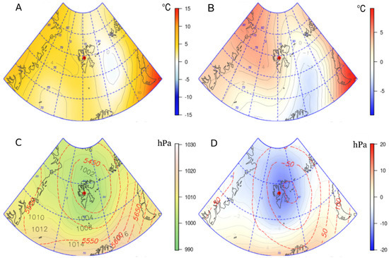
Figure 7.
Air temperature at an altitude of 850 hPa (T850) (°C)—grey solid line (A) and its anomalies (B) and the average daily sea-level pressure distribution (SLP) (hPa)—grey solid line and geopotential height of 500 hPa (m)—red dotted line (C) and its anomalies (D) for 20 July 2016. The red point shows the research area.
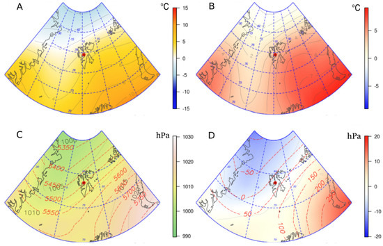
Figure 8.
Air temperature at an altitude of 850 hPa (T850) (°C)—grey solid line (A) and its anomalies (B) and the average daily sea-level pressure distribution (SLP) (hPa)—grey solid line and geopotential height of 500 hPa (m)—red dotted line (C) and its anomalies (D) for 20 August 2016. The red point shows the research area.
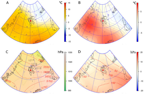
Figure 9.
Air temperature at an altitude of 850 hPa (T850) (°C)—grey solid line (A) and its anomalies (B) and the average daily sea-level pressure distribution (SLP) (hPa)—grey solid line and geopotential height of 500 hPa (m)—red dotted line (C) and its anomalies (D) for 23 July 2016. The red point shows the research area.
All days with cyclonal atmospheric circulation type and large cloudiness were characterized by a reduced atmospheric pressure from 4 to 8 hPa in relation to the average conditions, and a lower than average height for the 500 hPa geopotential. The air temperature of the 850 geopotential height was higher by about 2–3 °C than average (Figure 7 and Figure 8).
On July 23rd with the anticyclonic circulation type observed in the research area, sea-level pressure was higher than average by about 6 hPa. The 500 hPa geopotential height and the 850 hPa air temperature were higher than average by about 80 m and 2 °C, respectively (Figure 9).
4. Discussion
The comparison of cloudiness in Petuniabukta and Svalbard-Lufthavn in the summer of 2016 confirmed the occurrence of differences in cloud cover in both stations despite the relatively small distance between them. The average cloud cover in Svalbard-Lufthavn was 6.0 oktas, while for Petuniabukta it was 6.6 oktas. Attention is drawn to the highest frequency (61.5%) of cloudiness, amounting to 7 oktas in Svalbard Lufthavn, while Petuniabukta is most frequently clouded by 8 oktas (43%). Significant differences between the two stations regarding the last two degrees of sky coverage (7 and 8 oktas) are probably explained by the short period of research at Petuniabukta.
The Norwegian Arctic is considered one of the most clouded areas in the world [26]. The summer months tend to be the period with the largest cloud cover over Spitsbergen on the basis of both ground observations [12,27] and satellite data [28,29]. The highest cloud cover was found during the polar days by [30], because at this time glacier ablation takes place (usually between June and September). The results in [31] suggest that an increase in Arctic cloud cover due to reduced sea ice coverage may bring further sea ice retreat and enhance the feedback processes of Arctic warming. Moreover, there is an increased flow of maritime air masses from a south-western direction over Spitsbergen during that time. These masses bring heat and moisture over the land, cooling it at that time of the year [32,33], although [29] stated that it should be explained by the increased advection of air masses from the sector E-SE-S.
The frequency distribution of daily cloudiness in the considered stations is strongly skewed to the right. The number of cases with cloudiness >7 was the most numerous in the okta scale. In Petuniabukta, complete cloud cover (8/8) was the most often recorded, while in Svalbard-Lufthavn 7/8 was noted as the most frequent. Diurnal cloudiness is characterized by a great variability in both stations. The course of cloudiness shows a similarity in the studied period, while the series of days with the same degree of cloudiness are short. A cloudy or an overcast day is often followed by a clear day. Days with zero mean cloudiness were not found at all in both stations, while a sequence of days with a mean diurnal complete cloud cover was recorded far more often. The authors of [12] explained that one of the reasons for such a situation in Hornsund was the occurrence of orographic clouds over the rising ground in the observer’s field of vision. According to [11], the frequent fluctuations in the amount of cloud suggest that rapid changes occur in the polar regions’ atmosphere.
Low-level clouds prevailed in both stations in the summer of 2016. The least frequent were the high clouds. The research of [5] confirmed that low-altitude clouds in the Arctic were observed particularly in summer and early autumn. Clear sky days were not expected during this season, and there are some differences in the structure of cloud cover between Petuniabukta and Svalbard-Lufthavn. Over Petuniabukta, Stratus clouds occurred more often, while in Svalbard Stratocumulus dominated. It is also worth noting the lower frequency of medium cloud level in Petuniabukta compared to Svalbard-Lufthavn. The differences may be due to local conditions at each station. The authors of [12] observed that in Hornsund, stratocumulus clouds were the most frequently observed in all seasons. They are connected with passage bands of cloud in cyclonal systems or form below inversions at the edge of anticyclones. Stratus clouds occur very frequently in Hornsund, and they often form on the mountains’ windward slopes during light wind conditions—an indication of their orographic genesis [12].
Generally, the anticyclonic types of circulation are favorable to small cloudiness, in turn the cyclonic types are more conducive to the highest cloud cover. Compared with the 1951–2000 reference period, there were many more days with cyclonic circulation types than anticyclonic ones in the considered period [34]. Moreover, similar to our results and based on a short period of observations in Petuniabukta in 2013, [18] found that the types of circulation associated with a large cloud cover are: NWc, SWc, and Nc.
The measurement points show variations in the appearance of stratocumulus and stratus clouds. In Svalbard-Lufthavn, stratocumulus is observed more frequently in cyclonic circulation types. Stratus clouds are observed more frequently in Petuniabukta, and these occur in all types of circulation. Cloudiness of medium and high levels at the Petuniabukta point is not often observed. Comparing the relative frequency of cloud types and circulation types in Petuniabukta and Svalbard-Lufthavn, it is not possible to clearly determine what type of circulation ought to be associated with the formation of which particular cloud type. The results of [18] confirm that point. The direction of air or/and the local environmental features might have the most decisive influence.
During days with small cloudiness, the study area was directly affected by a high-pressure system or on the edge of such a system. Similar results were obtained by [20], i.e., sunny weather in Svalbard-Lufthavn occurred when a distinct anticyclone spread over the Svalbard archipelago and to the west. The circulation types (Ea, NEa, and Ka), according to the calendar of circulation types in [23], occurred during days with small cloudiness. The writers of [35] stated that types Ea + SEa favour the lowest values of cloudiness in the summer season. Later research by [14] proved that the smallest degree of cloudiness was related to the anticyclonic types: Ea + SEa and NWa + Na + NEa.
During cloudy days, the examined area was under the direct influence of a low-pressure system, a low-pressure trough, or, on the northern and north-western wedge, a high-pressure system. The same pressure pattern, enhancing the southerly and south-westerly flow of humid air masses, was also the reason for the extremely cloudy weather in summer over Spitsbergen according to [20]. On such days, circulation types (Cc, SWc, and SWa) occurred. Also, [21] found that the highest mean daily cloud cover was reported for circulation types with air advection from the south (S + SWc and S + SWa). The authors of [36] explained the higher degree of cloudiness in terms of the influence of circulation, especially cyclonic, particularly the inflow of air masses from the southern sector, i.e., from the Atlantic. According to [32], types Cc + Bc and Sc + SWc + Wc favour the highest cloud cover in the summer season. Based on observations in the summer of 2006, [14] proved that the highest cloudiness on the western coast of Spitsbergen was related to types Ec + SEc and Cc + Bc.
On days with cyclonic atmospheric circulation type, large cloudiness was characterized by a reduced atmospheric pressure from 4 to 8 hPa in relation to the average conditions, and a lower than average height for the 500 hPa geopotential. The air temperature on the 850 geopotential height was about 2–3 °C higher than average. On days with anticyclonic circulation type, the sea-level pressure, observed in the research area, was about 6 hPa higher than the average. The 500 hPa geopotential height as well as 850 hPa air temperature were higher than the average of about 80 m and 2 °C, respectively. According to research by [37], based on GCMs, cloudiness is not significantly correlated with changes in the sea-level pressure, which means that it is not influenced by circulation patterns. On the other hand, [38] considered dynamic influences, i.e., meridional moisture transport into the Arctic, a key factor in explaining the response of middle and high clouds. The results obtained in the study of [20] demonstrate that in the period 1980–2010, cloudiness over Spitsbergen was strongly controlled by the air circulation arising from pressure patterns. In summer, sunny weather occurred during anticyclone periods over the Svalbard archipelago. In turn, extremely cloudy conditions occurred when a weak anticyclone spread over the Barents Sea, the Novaya Zemlya archipelago, and the Kara Sea. It caused southerly and south-westerly advection of humid air.
The researchers in [27] showed that the causal relationship between cloudiness and respective circulation types is not as important as the direction of air masses’ advection. The authors of [18] documented significant differences in cloudiness and the formation of low-level clouds based on the prevailing large-scale flow reaching the Svalbard archipelago, all of which proved the enormous impact of large-scale circulation systems.
5. Conclusions
The research results confirm the relationship between cloudiness and atmospheric circulation. However, despite the relatively short distance between the considered stations, cloudiness in the study period varied according to location:
- The average cloud cover in summer 2016 was lower in Svalbard-Lufthavn (6.0 oktas) than in Petuniabukta (6.6 oktas). Small cloudiness was associated mainly with a high-pressure system or the edge of one. Large cloudiness occurred in low-pressure systems, a low-pressure trough, and on the north or north-western wedge of a high-pressure system. According to the typology proposed by Niedźwiedź, maximum cloudiness in both stations is related to the cyclonic circulation types SWc and Cc and one type of anticyclonal type SWa. Apart from that, in Svalbard-Lufthavn type Bc plays a significant role, as does type NWc in Petuniabukta. Minimal cloudiness in both stations occurred with the NEa type of circulation.
The synoptic situations causing extremely small or large cloudiness, identified on the basis of the presented research period, confirm the results achieved by [20] for summer time calculated for Svalbard-Lufthavn in the period 1980–2010. Similar results were also presented in a paper by [27] for the period 1983–2013 and [18] as well.
- 2.
- Local features of cloudiness are recorded most clearly in the structure of middle-level and low-level clouds. The frequency of middle-level clouds was much lower in Petuniabukta where Stratus clouds dominated, while Stratocumulus prevailed in Svalbard-Lufthavn. This means that the occurrence of cloud types is associated with the direction of air mass advection and may as well suggest the influence of local environmental conditions. This issue was indicated by [38] in work on factors influencing simulated changes in future Arctic cloudiness.
Despite the rather short period of observation, information concerning the influence of locally shaped environmental conditions on cloud cover could be relevant to research into the global climate system, radiation balance, and touristic and biometeorological issues [39], not to mention evaluating places for location, e.g., telemetric devices [40,41,42]. Moreover, the presented results from this study could be important in seeking a better understanding of the influence of both atmospheric circulation and local conditions on cloud cover in an age of very dynamic climate changes in the Arctic (IPCC 2007) [43].
Author Contributions
Conceptualization, L.K., M.P., S.K., and K.L.; methodology, M.P., L.K., and S.K.; software, M.P. and S.K.; validation, K.L., M.P., and K.L.; formal analysis, K.S.-P.; investigation, S.K.; resources, M.P., L.K., and S.K.; data curation, M.P. and S.K.; writing—original draft preparation, L.K., M.P., S.K., K.S.-P., and K.L.; writing—review and editing, L.K. and M.P.; visualization, M.P.; supervision, L.K.; project administration, L.K. and M.P. All authors have read and agreed to the published version of the manuscript.
Funding
Not applicable.
Institutional Review Board Statement
Not applicable.
Informed Consent Statement
The work of K.L. was supported by the project of Masaryk University MUNI/A/1356/2019 and the Czech Polar Research Infrastructure project (LM2015078).
Data Availability Statement
The data presented in the study are available on request from the corresponding author.
Conflicts of Interest
The authors declare no conflict of interest.
References
- Boucher, O.; Randall, D.; Artaxo, P.; Bretherton, C.; Feingold, G.; Forster, P.; Kerminen, V.-M.; Kondo, Y.; Liao, H.; Lohmann, U.; et al. Book Clouds and aerosols. In Climate Change 2013: The Physical Science Basis. Contribution of Working Group I to the Fifth Assessment Report of the Intergovernmental Panel on Climate Change; Cambridge University Press: Cambridge, UK, 2013; pp. 571–657. [Google Scholar]
- Bernstein, L.; Bosch, P.; Canziani, O.; Chen, Z.; Christ, R.; Riahi, K. IPCC, 2007: Climate Change 2007: Synthesis Report; IPCC: Geneva, Switzerland, 2008; ISBN 2-9169-122-4. [Google Scholar]
- Niedźwiedź, T.; Ustrnul, Z. The influence of synoptic situations on the formation of clouds in Hornsund. In XVI Sympozjum Polarne; Wyd. Uniwersytetu w Toruniu: Toruń, Poland, 1989; pp. 158–160. [Google Scholar]
- Brohan, P.; Kennedy, J.J.; Harris, I.; Tett, S.F.; Jones, P.D. Uncertainty estimates in regional and global observed temperature changes: A new data set from 1850. J. Geophys. Res. Atmos. 2006, 111, 1–21. [Google Scholar] [CrossRef]
- Shiobara, M.; Yabuki, M.; Kobayashi, H. A polar cloud analysis based on Micro-pulse Lidar measurements at Ny-Alesund, Svalbard and Syowa, Antarctica. Phys. Chem. Earth 2003, 28, 1205–1212. [Google Scholar] [CrossRef]
- Gayet, J.-F.; Mioche, G.; Dörnbrack, A.; Ehrlich, A.; Lampert, A.; Wendisch, M. Microphysical and optical properties of Arctic mixed-phase clouds. the 9 April 2007 case study. Atmos. Chem. Phys. 2009, 9, 6581–6595. [Google Scholar] [CrossRef]
- Jourdan, O.; Mioche, G.; Garrett, T.J.; Schwarzenböck, A.; Vidot, J.; Xie, Y.; Shcherbakov, V.; Yang, P.; Gayet, J.-F. Coupling of the microphysical and optical properties of an Arctic nimbostratus cloud during the ASTAR 2004 experiment: Implications for light-scattering modelling. J. Geophys. Res. Atmos. 2010, 115, 1–16. [Google Scholar] [CrossRef]
- Bierwirth, E.; Ehrlich, A.; Wendisch, M.; Gayet, J.-F.; Gourbeyre, C.; Dupuy, R.; Herber, A.; Neuber, R.; Lampert, A. Optical thickness and effective radius of Arctic boundary-layer clouds retrieved from airborne nadir and imaging spectrometry. Atmos. Meas. Tech. 2013, 6, 1189–1200. [Google Scholar] [CrossRef]
- O’Neill, N.T.; Baibakov, K.; Hesaraki, S.; Ivanescu, L.; Martin, R.V.; Perro, C.; Chaubey, J.P.; Herber, A.; Duck, T.J. Temporal and spectral cloud screening of polar winter aerosol optical depth (AOD): Impact of homogeneous and inhomogeneous clouds and crystal layers on climatological-scale AODs. Atmos. Chem. Phys. 2016, 16, 12753–12765. [Google Scholar] [CrossRef]
- Dörnbrack, A.; Gisinger, S.; Pitts, M.C.; Poole, L.R.; Maturilli, M. Multilevel cloud structures over Svalbard. Mon. Weather Rev. 2017, 145, 1149–1159. [Google Scholar] [CrossRef] [PubMed]
- Matuszko, D.; Soroka, J. Book Cloudiness over Spitsbergen, Based on Observations Made at the Polish Polar Station in Hornsund, 2013; Instytut Geografii i Gospodarki Przestrzennej, UJ: Kraków, Poland, 2013; p. 96. [Google Scholar]
- Marsz, A. Cloudiness and sunshine duration. In Book Climate and Climate Change at Hornsund, Svalbard; Gdynia Maritime University: Gdynia, Poland, 2013; pp. 101–125. [Google Scholar]
- Gluza, A.; Siłuch, M.; Siwek, K. Comparison of some selected meteorological elements of the Summer season between Hornsund and Calypsobyen stations (Spitsbergen). Probl. Klimatol. Polarn. 2004, 14, 183–188. (In Polish) [Google Scholar]
- Przybylak, R.; Kejna, M.; Araźny, A.; Maszewski, R.; Gluza, A.; Hojan, M.; Zwoliński, Z. Diversification of Meteorological Conditions on the Western Coast of Spitsbergen during Summer Season of 2006; Uniwersytet im. Mikołaja Kopernika: Toruń, Poland, 2007; pp. 179–194. [Google Scholar]
- Kejna, M.; Przybylak, R.; Araźny, A. The influence of cloudiness and synoptic situations on the solar radiation balance in the area of Kaffiøyra (NW Spitsbergen) in the summer seasons 2010 and 2011. Bull. Geography. Phys. Geogr. Ser. 2012, 5, 77–95. [Google Scholar] [CrossRef]
- Aas, K.S.; Bernstein, T.K.; Boike, J.; Etzelműller, B.; Kristjánsson, J.E.; Maturilli, M.; Schuler, T.V.; Stordal, F.; Westermann, S. A comparison between simulated and observed surface energy balance at the Svalbard Archipelago. J. Appl. Meteorol. Climatol. 2015, 54, 1102–1119. [Google Scholar] [CrossRef][Green Version]
- Rachlewicz, G. Meteorological conditions in Petunia Bay (central Spitsbergen) during summer seasons 2000 and 2001. Probl. Klimatol. Polarn. 2003, 13, 127–138. [Google Scholar]
- Láska, K.; Chládová, Z.; Ambrožová, K.; Husák, J. Cloudiness and weather variation in central Svalbard in July 2013 as related to atmospheric circulation. Czech Polar Rep. 2013, 3, 184–195. [Google Scholar] [CrossRef]
- Przybylak, R.; Araźny, A.; Gluza, A.; Hojan, M.; Migała, K.; Sikora, S.; Zwoliński, Z. Diversification of meteorological conditions on the western coast of Spitsbergen during the summer season of 2005. Probl. Klimatol. Polarn. 2006, 16, 125–138. [Google Scholar]
- Bednorz, E.; Kaczmarek, D.; Dudlik, P. Atmospheric conditions governing anomalies of the summer and winter cloudiness in Spitsbergen. Theor. Appl. Climatol. 2016, 123, 1–10. [Google Scholar] [CrossRef]
- Łupikasza, E.; Lipiński, O. Cloud cover over Spitsbergen and its relation to atmospheric circulation (1983–2015). Geogr. Pol. 2017, 90, 21–38. [Google Scholar] [CrossRef]
- Láska, K.; Witoszová, D.; Prošek, P. Weather patterns of the coastal zone of Petuniabukta (Central Spitsbergen) in the period 2008–2010. Pol. Polar Res. 2012, 33, 297–318. [Google Scholar] [CrossRef]
- Niedźwiedź, T. Kalendarz Typów Cyrkulacji Atmosfery dla Spitsbergenu—Zbiór Komputerowy, 2013, Uniwersytet Śląski, Katedra Klimatologii, Sosnowiec. 2013. Available online: http://www.kk.wnoz.us.edu.pl/nauka/kalendarz-typow-cyrkulacji/ (accessed on 20 September 2019).
- Kalnay, E.; Kanamitsu, M.; Kistler, R.; Collins, W.; Deaven, D.; Gandin, L.; Zhu, Y. The NCEP/NCAR 40-year reanalysis project. Bull. Am. Meteorol. Soc. 1996, 77, 437–472. [Google Scholar] [CrossRef]
- Rachlewicz, G.; Styszyńska, A. Comparison of the course air temperature in Petuniabukta and Svalbard-Lufthavn (Isfjord, Spitsbergen) in the years 2001–2003). Probl. Klimatol. Polarn. 2007, 17, 121–134. [Google Scholar]
- Przybylak, R. Book The Climate of the Arctic; Kluwer Academic Publishers: Dordrecht, The Netherlands, 2003; pp. 1–286. [Google Scholar]
- Lipiński, O.; Łupikasza, E. The role of atmospheric circulation in shaping total cloudiness over Spitsbergen (1983–2013). Przegląd Geogr. 2016, 88, 317–337. [Google Scholar] [CrossRef]
- Schweiger, A.J.; Key, J.R. Arctic cloudiness: Comparison of ISCCP-C2 and NIMBUS-7 satellite-derived cloud products with surface-based climatology. J. Clim. 1992, 5, 1514–1527. [Google Scholar] [CrossRef]
- Kotarba, A.; Widawski, A. The satellite cloud climatology in 2007 above Svalbard in relation to atmospheric circulation conditions. Probl. Klimatol. Polarn. 2008, 18, 127–140. [Google Scholar]
- Kryza, M.; Szymanowski, M.; Migała, K. Estimation of the real-sky total solar irradiation for the Werenskjold glacier (SW Spitsbergen) with the r.sun model (SW Spitsbergen). Pr. Studia Geogr. 2011, 47, 435–442. (In Polish) [Google Scholar]
- Abe, M.; Nozawa, T.; Ogura, T.; Takata, K. Effect of retreating sea ice on Arctic aloud cover in simulated recent global warming. Atmos. Chem. Phys. 2016, 16, 14343–14356. [Google Scholar] [CrossRef]
- Araźny, A. Annual course of relative air humidity in the Norwegian Arctic from 1971 to 2000. Probl. Klimatol. Polarn. 2003, 13, 107–115. [Google Scholar]
- Niedźwiedź, T. The main features of circulation over Spitsbergen. Problemy Klimatologii Polarnej 2006, 16, 91–105. [Google Scholar]
- Kendzierski, S.; Kolendowicz, L.; Półrolniczak, M. The influence of synoptic condition patterns on air temperature and humidity in Petuniabukta (Svalbard) in summer 2016. Pol. Polar Res. 2018, 39, 371–392. [Google Scholar]
- Przybylak, R. Spatial differentiation of air temperature and relative humidity on the western coast of Spitsbergen in 1979–1983. Pol. Polar Res. 1992, 13, 113–130. [Google Scholar]
- Adamczyk, R.; Ustrnul, Z. Total cloudiness with relation to the atmospheric circulation in the European polar region. Probl. Klimatol. Polarn. 2008, 18, 79–88. [Google Scholar]
- Vavrus, S.; Waliser, D.; Schweiger, A.; Francis, J. Simulations of 20th and 21st century Arctic clouds in the global climate models assessed in the IPCC AR4. Clim. Dyn. 2009, 33, 1099–1115. [Google Scholar] [CrossRef]
- Vavrus, S.; Bhatt, U.S.; Alexeev, V.A. Factors influencing simulated changes in future arctic cloudiness. J. Clim. 2011, 24, 4817–4830. [Google Scholar] [CrossRef]
- Denstadli, J.M.; Jacobsen, J.K.S. More Clouds on the Horizon? Polar Tourists’ Weather Tolerances in the Context of Climate Change. Scand. J. Hosp. Tour. 2014, 14, 80–99. [Google Scholar] [CrossRef][Green Version]
- Hellemeier, J.A.; Yang, R.; Sarazin, M.; Hickson, P. Weather at selected astronomical sites—An overview of five atmospheric parameters. Mon. Not. R. Astron. Soc. 2019, 482, 4941–4950. [Google Scholar] [CrossRef]
- Liu, Y.; Zhao, L. The preliminary analysis of sunshine durations with meteorological data for the Chinese Giant Solar Telescope site survey. Mon. Not. R. Astron. Soc. 2013, 434, 1674–1680. [Google Scholar] [CrossRef]
- Shikhovtsev, A.Y.; Bolbasova, L.A.; Kovadlo, P.G.; Kiselev, A.V. Atmospheric parameters at the 6-m Big Telescope Alt-azimuthal site. Mon. Not. R. Astron. Soc. 2020, 493, 723–729. [Google Scholar] [CrossRef]
- IPCC. Climate Change 2007: The Physical Science Basis, Summary for Policymakers; IPCC: Geneva, Switzerland, 2007; p. 18. [Google Scholar]
Publisher’s Note: MDPI stays neutral with regard to jurisdictional claims in published maps and institutional affiliations. |
© 2021 by the authors. Licensee MDPI, Basel, Switzerland. This article is an open access article distributed under the terms and conditions of the Creative Commons Attribution (CC BY) license (https://creativecommons.org/licenses/by/4.0/).