Article

Evaluation of the Perspective of ERA-Interim and ERA5 Reanalyses for Calculation of Drought Indicators for Uzbekistan

by
Natella Rakhmatova
1,*,
Mikhail Arushanov
1,
Lyudmila Shardakova
1,
Bakhriddin Nishonov
2,
Raisa Taryannikova
2,
Valeriya Rakhmatova
2 and
Dmitry A. Belikov
3,*
1
Research Hydrometeorological Institute (NIGMI), Centre of Hydrometeorological Service of the Republic of Uzbekistan (Uzhydromet), 72, 1st Bodomzor yuli str., Tashkent 100052, Uzbekistan
2
Centre of Hydrometeorological Service of the Republic of Uzbekistan (Uzhydromet), 72, 1st Bodomzor yuli str., Tashkent 100052, Uzbekistan
3
Center for Environmental Remote Sensing, Chiba University, 1–33 Yayoi-cho, Inage-ku, Chiba 263-8522, Japan
*
Authors to whom correspondence should be addressed.
Atmosphere 2021, 12(5), 527; https://doi.org/10.3390/atmos12050527
Submission received: 29 March 2021 / Revised: 14 April 2021 / Accepted: 15 April 2021 / Published: 21 April 2021
(This article belongs to the Section Biosphere/Hydrosphere/Land–Atmosphere Interactions)

Abstract

:
The arid and semiarid regions of Uzbekistan are sensitive and vulnerable to climate change. However, the sparse and very unevenly distributed meteorological stations within the region provide limited data for studying the region’s climate variation. The aim of this work was to evaluate the performance of the European Centre for Medium-Range Weather Forecasts (ECMWF) Re-Analysis (ERA)-Interim and ERA5 products for the fields of near-surface temperature, humidity, and precipitation over Uzbekistan from 1981 to 2018 using observations from 74 meteorological stations. Major results suggested that the reanalysis datasets match well with most of the observed climate records, especially in the plain areas. While ERA5, with a high spatial resolution of 0.1°, is able more accurately reproduce mountain ranges and valleys. Compared to ERA-Interim, the climatological biases in temperature, humidity, and total precipitation from ERA5 are clearly reduced, and the representation of inter-annual variability is improved over most regions of Uzbekistan. Both reanalyses show a high level of agreement with observations on the standardized precipitation evaporation index (SPEI) with a correlation coefficient of 0.7–0.8.Although both of these ECMWF products can be successfully implemented for the calculation of atmospheric drought indicators for Uzbekistan and adjacent regions of Central Asia, the newer and advanced ERA5 is preferred.

1. Introduction

Drought is a dangerous natural hazard characterized by a lower-than-normal water supply insufficient to meet the demands of human activities and the environment [1]. In Uzbekistan, droughts are the dominant natural disasters, which negatively affect the country’s population, key sectors of the economy, and the environment [2] and may lead to serious food insecurity [3,4,5,6,7]. According to the report of the Intergovernmental Panel on Climate Change (IPCC), future climate change will lead to an increase in climate variability and in frequency and intensity of extreme events in the world [8]. Uzbekistan’s national estimates report a shortage of water resources and climatic changes in response to an increase in the frequency and duration of droughts [9].
In order to mitigate the consequences of drought, it is necessary to develop a monitoring system and forecasting methods that are based on various indicators of drought, which have usually complex characteristics. In this regard, reliable climate information is the basis for developing a climate-resilient system to minimize the region’s vulnerability to various climatic risks. Assessment of drought parameters (frequency, extent, and coverage) requires high-quality country-wide meteorological data (temperature, humidity, water pressure deficit, etc.) with high spatial and temporal resolution over a long period of time. However, detailed observations are not always available for all required locations and variables.
Reanalysis data are a commonly used technique to solve the lack of observation issue. Usually, reanalysis is the result of calculations by a global atmospheric model with regular assimilation of available meteorological observations followed by interpolation into a regular global grid to determine the state of the atmosphere where observations are unavailable [10,11,12]. However, the accuracy of reanalysis data varies strongly between regions and variables [13,14,15]. In regions with few observations or complex terrain, reanalysis products may suffer from large biases; therefore, temperature data are generally more reliable than other data [13,15,16,17].
The eight reanalysis datasets were estimated over Central Asia using the spatiotemporal variations of column-integrated precipitable water vapor amount based on evaluations of multiple satellite and reanalyses against radiosonde observations [18]. Considered datasets include the European Centre for Medium-Range Weather Forecasts (ECMWF) ERA-Interim [11], the fifth generation ECMWF atmospheric reanalysis of the global climate ERA5 [10], the National Centers for Environmental Prediction/National Center for Atmosphere Research Reanalysis (NCEP1) [19], the NCEP-U.S. Department of Energy Reanalysis (NCEP2) [20], the NCEP Climate Forecast System Reanalysis (CFSR) [21], the 55-year modern Japanese Reanalysis Projects [22,23], the Modern Era Retrospective-Analysis for Research and Applications (MERRA) [24], and MERRA version 2 (MERRA2) [25]. Although all reanalyses can reasonably reproduce the spatiotemporal variations of precipitable water vapor, ERA5 and MERRA2 (NCEP1 and NCEP2) perform better (poorer) compared with other datasets. In terms of climatological mean and interannual variations of precipitation water vapor, ERA-5 is recommended in Central Asia. The near-surface air temperature changes in Central Asia from 1979 to 2011 were examined using observations from 81 meteorological stations and three reanalyses NCEP CFSR, ERA-Interim, and MERRA [26]. Major results suggested that three datasets match well with most of the local climate records, especially in the low-lying plain areas.
A comprehensive evaluation of temperature and precipitation, which are the most widely used climate variables [19], in terms of reproducing the temporal and spatial variability as well as the observed long-term trend is necessary to judge the reliability of data for Uzbekistan climate research and operational use. Therefore, the goal of this work was to assess the possibility of using temperature, humidity, and precipitation from the ERA-Interim (hereafter ERA-I) and ERA5 (hereafter ERA-5) for the territory of Uzbekistan, as a basis for calculating indices and spatial and temporal characteristics of drought. To achieve this goal, the following tasks were solved: comparison of ERA-I and ERA-5 reanalysis data with observations at meteorological stations; conducting statistical evaluations; calculation of water pressure deficit in the air using reanalysis data; spatiotemporal assessment of the distribution of meteorological values on the territory of Uzbekistan; assessment of trends in drought parameters.
The rest of the paper is composed as follows: Section 2 describes the datasets and methods employed in this study. The performance of the reanalyses at the country scale is discussed in Section 3. Finally, the summary and conclusions are provided in Section 4.

2. Data and Method

2.1. Study Domain

The Republic of Uzbekistan is located in Central Asia between the Amudarya and Syrdarya rivers. Uzbekistan has three main climate zones: a zone of deserts and dry steppes occupying about 79% of the territory, the foothills zone, and the area of high mountains extending over the remaining 21% [7]. The climate in most areas is dominated by low precipitation, intensive evaporation, and large diurnal and annual fluctuations of temperature, especially in the lowlands. Mountainous areas, respectively, having lower annual mean temperatures but more precipitation. More precipitation occurs during winter and early spring, whereas summers are usually hot and dry [27]. July is the hottest month of the year, while the mean air temperature in the greater part of the lowlands is close to 30 °C in the south and desert areas. The maximum values can reach up to 45 °C in the southern part of Uzbekistan, with a record temperature of over 50 °C observed in Termez and the Kyzylkum Desert [28]. The coldest month is January, when the mean air temperature drops to 0−8 °C in the south and north of the country, respectively. In extremely cold years, the minimum temperature can be below −40 °C on the Ustyurt Plateau.
The Republic of Uzbekistan consists of 12 provinces, which were conditionally divided into 5 regions as geographically homogeneous territories in terms of climatic conditions and water supply with reference to the main rivers’ basins [29]. These territories are also homogeneous in the vulnerability degree of the main sectors—water and agriculture, and are planning zones within the river basins [30]: Amudarya basin includes South zone (SZ), Middle course of Amudarya (MCA), and Lower course of Amudarya (LCA); Syrdarya basin includes Fergana Valley (FV) and Middle Current of Syrdarya (MCS) (Table 1).

2.2. Observational and Reanalysis Data

2.2.1. Observations

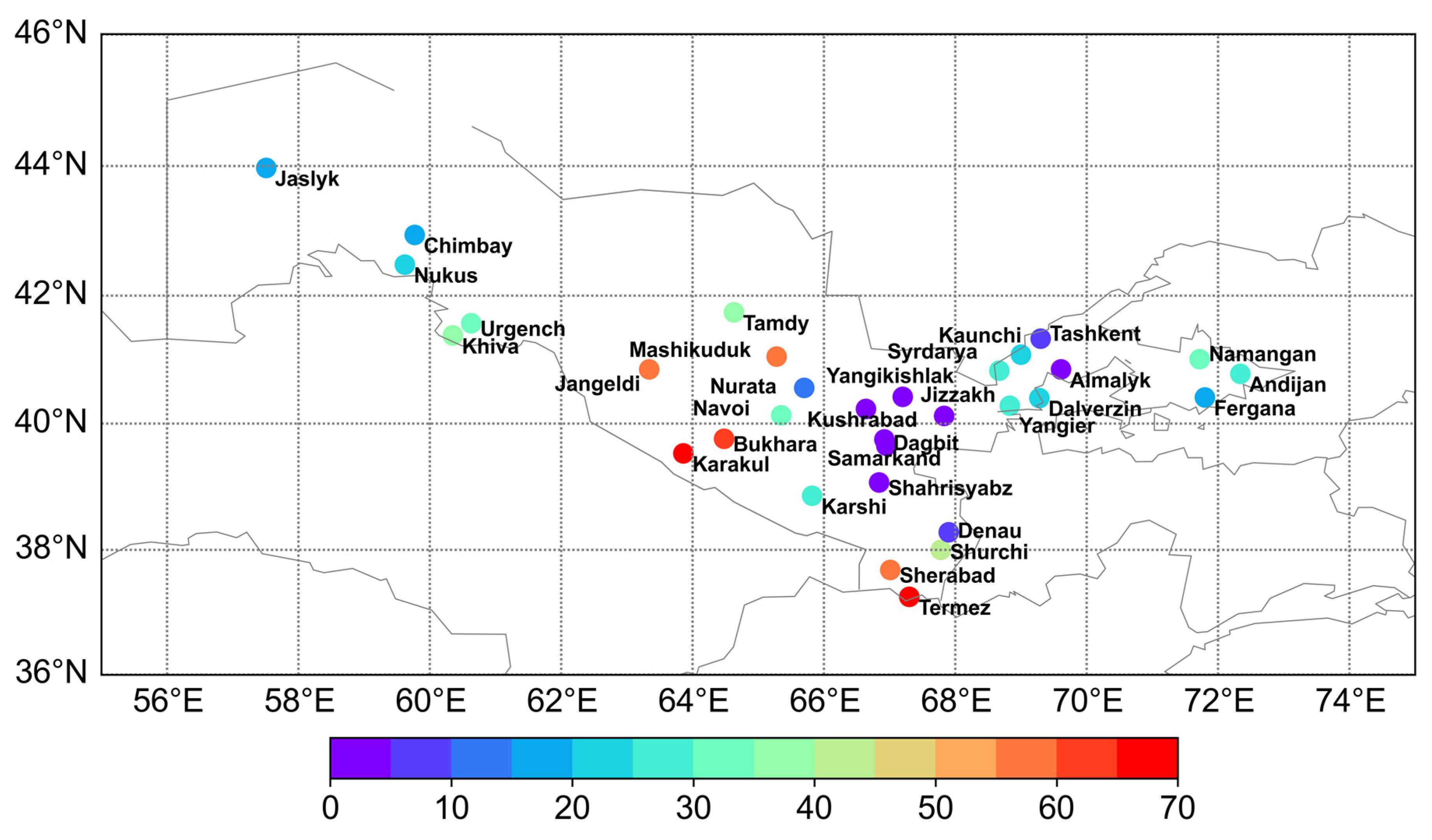
In this work, we used ground-based observation data from 74 meteorological stations, covered the entire territory of the Republic, as shown in Figure 1. The location of the observation stations reflects the population density, which is relatively higher in three foothill regions (FV, MCS, and SZ) in comparison to others (MCA and LCA) located in a flatter zone. Some data go back to 1881. Detailed archives of observations are still at the stage of digitization and verification; therefore, monthly averaged values are used in the analysis.

2.2.2. ERA-5 and ERA-I Reanalyses

In this paper, we compare ERA-I and ERA-5 reanalyses, which are the two most recent reanalysis products of the ECMWF. These datasets are produced by combining a numerical weather prediction model with observational data from satellites and ground observations. ERA-I was introduced in 2007 [11,31] and provided daily climate information until August 2019. Then it was replaced by ERA-5 [32,33], which provides hourly meteorological conditions from 1981 (expected to be extended back to 1950). Both versions of the ECMWF reanalysis are based on the Integrated Forecasting System (IFS) and include a four-dimensional variational analysis (4D-Var). There are several substantial differences between the two datasets concerning the forecast model, the observational input, and the estimation of uncertainty.
In contrast to the Cy31r2 version of IFS used for ERA-I, ERA-5 is running with the version Cy41r2 (https://www.ecmwf.int/en/forecasts/datasets/reanalysis-datasets/era-interim, accessed on 6 April 2021). ERA-5 data is available in higher spatial and temporal resolution: on a 0.25° grid (0.1° for the Land products) with hourly intervals, while ERA-I data is provided on a 0.75° grid with 6 h intervals. Additionally, the vertical resolution increased from 60 levels in ERA-I to 137 levels in ERA-5 [11,32]. The number of observational datasets that serve as input for the assimilation system was increased, and a major difference is in consideration of satellite estimates of precipitation in ERA-5.

2.2.3. Comparison Method

ERA-I and ERA-5 datasets are available from 1981, but ERA-I was discontinued in 2019. Therefore, the baseline period 1981–2018 is selected for the study. The following data were considered: mean ( T ) and maximum monthly temperature ( T m a x ), relative and absolute humidity ( R H ,   S H ), as well as total precipitation ( T P ) data from reanalysis and observed at meteorological stations for each month. The reanalysis data in the grid points were interpolated by the linear method to the geographic coordinates of the observation station.
The paper also presents a comparative analysis with the data of the State Cadastre of High Natural Hazard, Part I: Zones of increased danger of hydrometeorological phenomena (hereafter “Cadastre”) for the period 2005–2017 [20]. The Cadastre contains the results of observations at 34 of the most representative stations of the Center of Hydrometeorological Service of the Republic of Uzbekistan (Uzhydromet). From the Cadastre, the parameter “Number of days in a year with the vapor-pressure deficit (VPD) ≥ 50 hPa (hereafter “Number of days with VPD ≥ 50 hPa”), due to high temperature and low humidity, was chosen as an indicator of drought. Another parameter considered is “Number of days in a year with T m a x ≥ 40 °C (hereafter “Number of days with T m a x ≥ 40 °C”).
The parameters indicated above are used for the diagnosis of drought by Uzhydromet, based on previous studies [34]. However, recently, more universal indexes to estimate drought severity indexes were developed. The standardized precipitation evapotranspiration index (SPEI) was first proposed by [35] as an improved drought index which is especially appropriate for studies of the effect of global warming on drought strength. The SPEI considers the effect of reference evapotranspiration on drought severity, but the multi-scalar nature of the SPEI enables the identification of different drought types and drought impacts on diverse systems [35,36].
In this work, we followed the method described by [36] and implemented the SPEI calculation based on the R package SPEI (http://cran.r-project.org/web/packages/SPEI, accessed on 6 April 2021). From the several options available in the package, we used the recommended [36] log-logistic distribution of the probability density function, unbiased PWMs (Probability Weighted Moment), and the Hargreaves method [37] of calculating monthly potential evapotranspiration in modified form due to [38].

3. Results

3.1. Comparison with Field Observations

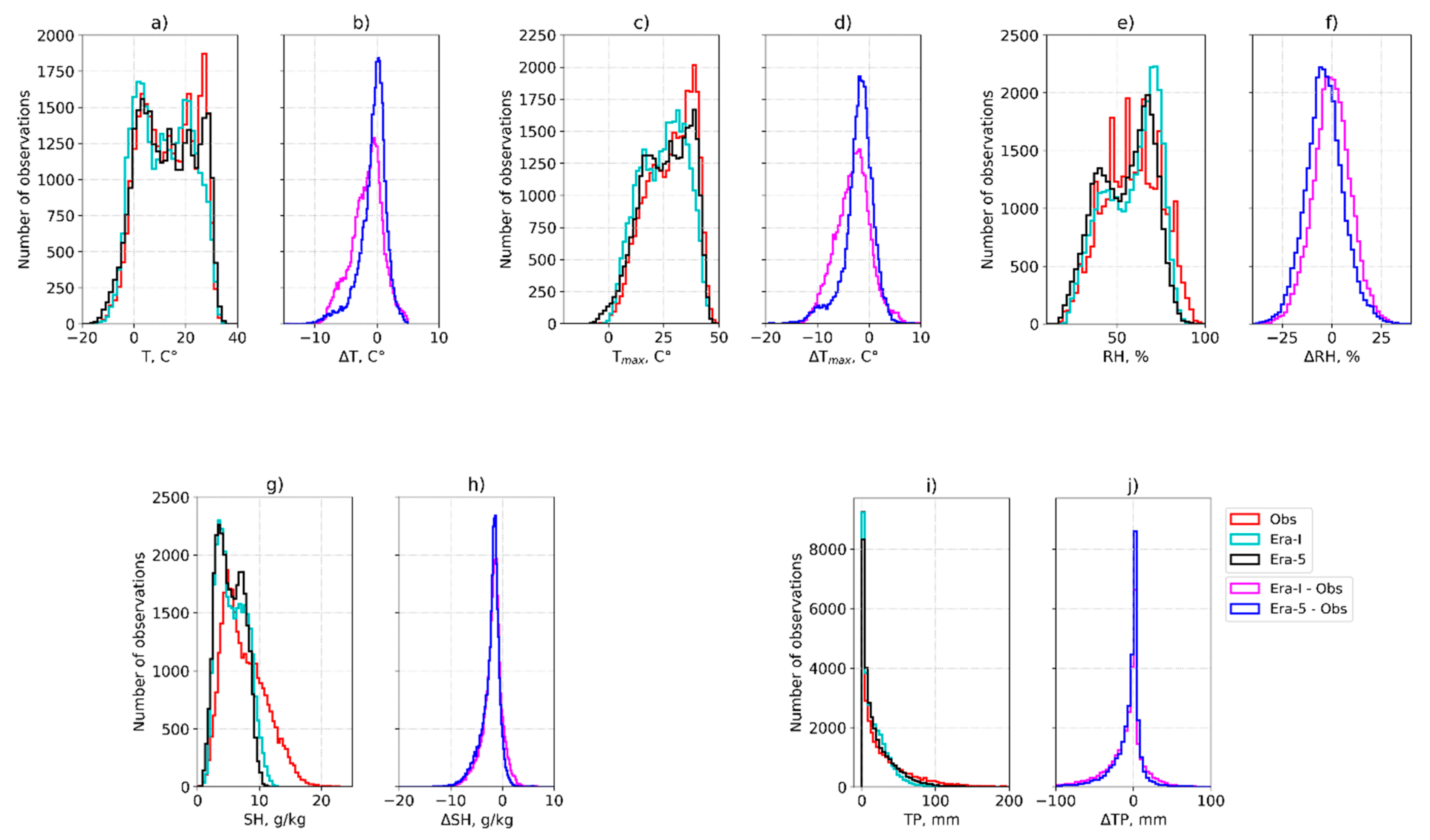
Figure 1 provides histograms, which show the frequency distributions of meteorological parameters at 74 meteorological stations in Uzbekistan according to observations and reanalyses (ERA-I, ERA-5) for the period 1981–2018. For each parameter, we considered a comparison of observations with values from ERA-I and ERA-5 (Figure 2a,c,e,g,i), as well as misfit between reanalysis data and ground observations ( Δ X ):
Δ X = X r X o b s ,
here X = { T ,   T m a x ,   R H , S H ,   T P }   is average monthly air temperature (Figure 2b), maximum monthly air temperature (Figure 2d), relative humidity (Figure 2f), absolute humidity (Figure 2h), and precipitation (Figure 2j), respectively. The superscripts “obs” and “r” correspond to observation and reanalysis data (ERA-I or ERA-5), respectively.
In general, the advantage of ERA-5 is noticeable. Mean parameters values and their variability (SD) from ERA-5 are closer to the observed (Table 2). The ERA-5 misfits are closer to the normal distribution (Figure 2), and the mean error and standard deviation are smaller (Table 3). Temperature peaks are better described. The representation of the annual cycle of precipitation is substantially improved in ERA-5 by reducing the wet bias. Nonetheless, we must emphasize the humidity in the reanalysis compared to observations, as a fat tail of high SH is not reproduced by reanalysis (Figure 2g). Table 2 indicates a deficit of reanalysis variability.
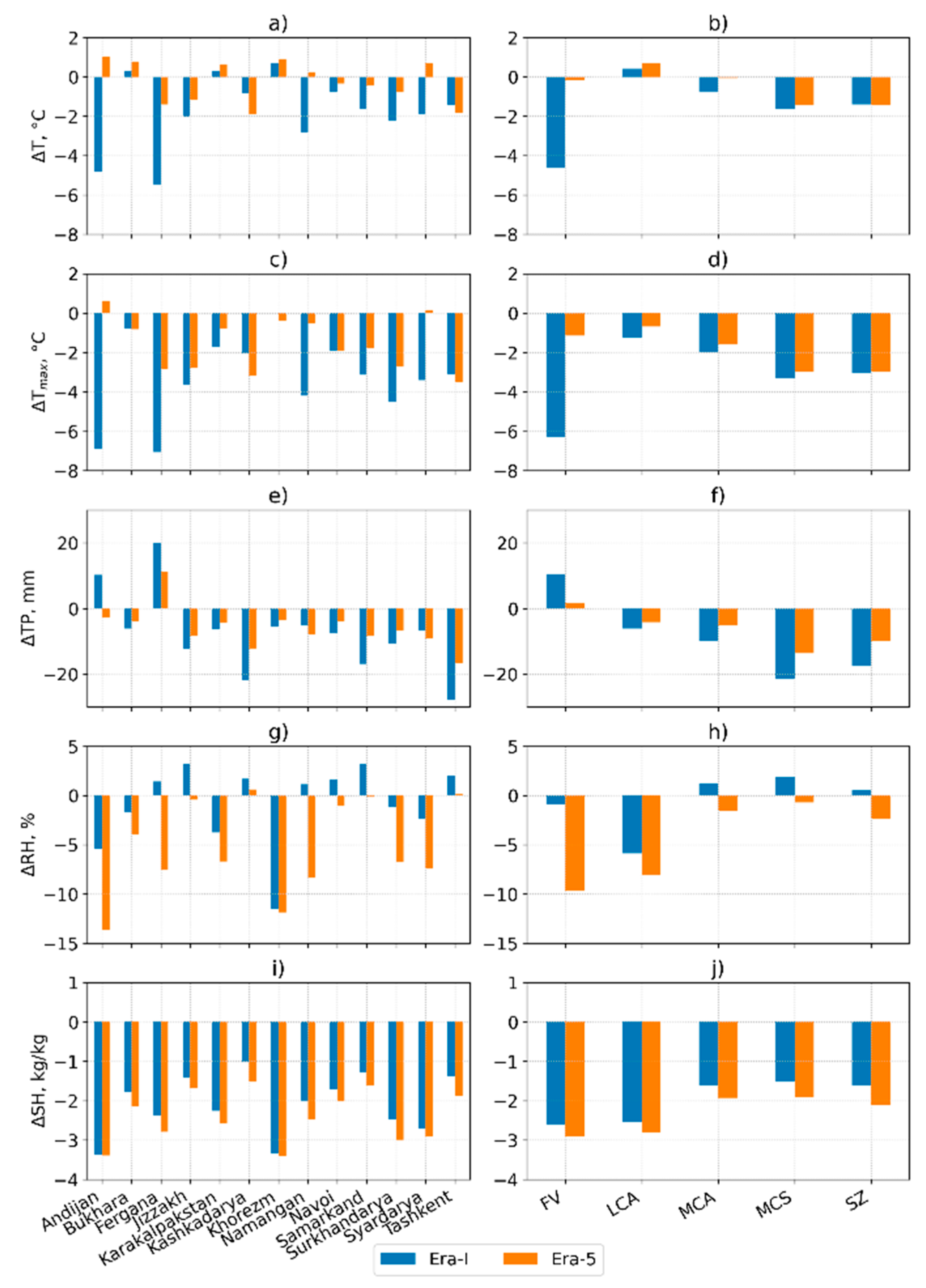
For absolute and relative air humidity, only slight progress is noticeable, and for several regions (Figure 3h,j), we even see significant degradation in the ERA-5 data. For these parameters, ERA-I gives better results, since with sufficiently close values of the correlation coefficient (hereafter, the Pearson correlation coefficient is used) of 0.85 and 0.88, approximately equal to the standard deviation, the average error is less. On this basis, it is preferable to use temperature characteristics and functions for deriving and calculation of drought indices.
To identify the areas with the greatest difference between observation and reanalysis data, temperature and precipitation differences were considered for the administrative provinces and regions (Table 1) for 1981–2018, as shown in Figure 3 and Figure 4.
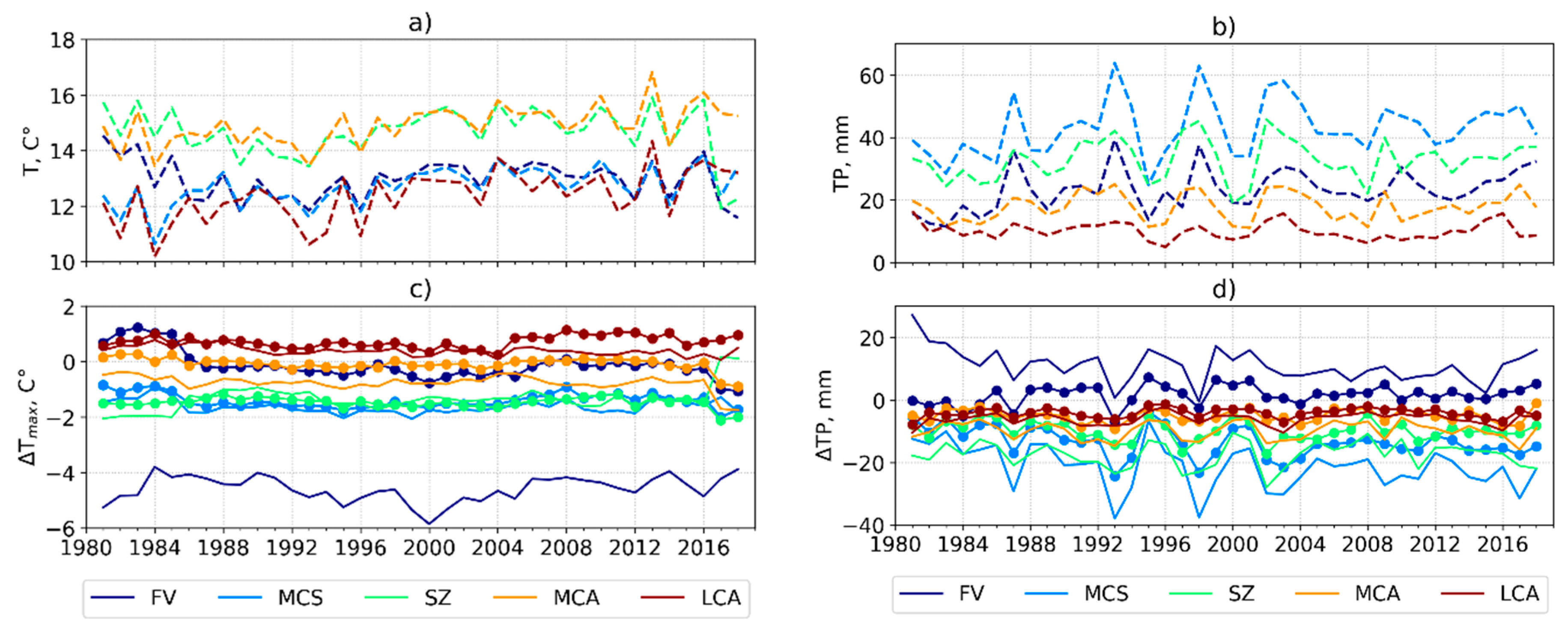
Figure 4 presents the dynamics of average annual temperatures and precipitation according to ground observations (panels a,b) and their residuals, ΔT = Tobs-TERA-5 (line with symbols) and ΔT = Tobs − TERA-I (solid line) (panels c,d). The observed average temperatures show a noticeable interannual variability of several degrees and a positive trend (Figure 4a). The discrepancy ΔT for regions 1–4 (Table 2) is close to stationary and lies within ±2 °C (Figure 4b). Thus, the reanalysis reproduces with satisfactory accuracy the average temperature for most regions of Uzbekistan, except the Fergana Valley, where ERA-I shows a significant discrepancy (>4 °C).
Similar to temperature, the average precipitation distribution in Uzbekistan has a sharp contrast between the plain and mountain areas. The mean monthly precipitation in major parts of the plains or deserts and dry steppes (Ustyurt Plateau, Kyzylkum Desert, Karshi, Dalverzin, and Golodnaya steppe) is about 5–20 mm. However, precipitation can be significantly greater in some foothills areas and the mountains, particularly in the northeast and the southeast of the country. In fact, precipitation in areas with an elevation between 600 and 1000 m or foothills areas (Tien Shan and Gissar–Alai mountain ranges) can reach up to 500 mm annual totals and may exceed 500 mm above the level of 1000 m, as stated in [27]. Moreover, the observation stations are below these heights, so monthly average values are below 100 mm (Figure 3b). The discrepancy in precipitation shows marked interannual variability with maximum values outside the range ±15 mm for the FV and MCS regions located in foothill areas (Figure 3d).
Figure 5 and Figure 6 show the spatial distribution of the field of the mean long-term averaged air temperature and precipitation for August (the driest month in Uzbekistan) 1981–2018 derived from ERA-I and ERA-5, respectively. These figures demonstrate the difference between ERA-I and ERA-5 temperature fields in conditions of high heterogeneity due to the complex relief of foothill and mountain zones. In the reanalysis data processing, the land surface is strongly associated with the defined horizontal grid. Therefore, in ERA-I elevations, the average temperature and precipitation are more smoothed due to a relatively coarse grid. ERA-5, with a spatial resolution of 0.1°, is able to more accurately reproduce mountain ranges and valleys and, as a result, the processes taking place there. Thus, the ERA-I underestimates/overestimates mean temperature in the near-mountain/high-mountain zones (e.g., see plains and mounts in FV) in comparison with the ERA-5. The influence of the spatial resolution is even more noticeable in the distribution of precipitation (Figure 6). Thus, for the FV, it is essential to use ERA-5, while for the western regions of Uzbekistan, ERA-I is quite acceptable.

3.2. Comparison with the Cadaster

Daily VPD is an indicator of atmospheric drought, characterized by high temperatures and low humidity. VPD is the difference/deficiency between the amount of moisture in the air and how much moisture the air can hold in a saturation state:
V P D = P v s P v ,
where P v s is water vapor pressure at saturation, and P v is the actual water vapor pressure for a given temperature.
It was observed that VPD increased slightly before the late 1990s but increased more strongly afterward, according to four reanalysis datasets, including ERA-I [39]. Changes in VPD are important for terrestrial ecosystem structure and function. Leaf and canopy photosynthetic rates decline when atmospheric VPD increases due to stomatal closure. A recent study highlighted that increases in VPD rather than changes in precipitation substantially influenced vegetation productivity, vegetation growth, forest mortality, and maize yields [39,40,41,42]. In Uzbekistan, the parameter Number of days with VPD ≥ 50 was adopted as the drought criterion. This indicator is determined by the complex nature of atmospheric circulation—synoptic processes prevailing in the warm season, lack of precipitation in summer, and the persistence of thermal depression for a long time over the territory. The period of thermal depression is characterized by the absence of inflow of fresh air masses, significant heating, drying, and a dusting of the surface air layer. Accordingly, the combination of high temperatures with low relative humidity determines a high deficit of air humidity, exceeding 50 hPa during daytime observations. For the territory of Uzbekistan, the following scale of values for the daily deficit of air humidity was adopted as an indicator of atmospheric drought intensity (Table 4) [7].
There are many options for calculating the partial pressure of water vapor. As it was noted above that the air temperature in reanalysis datasets is in good agreement with observations at meteorological stations, we decided to calculate the partial pressure of water vapor using temperature field on the basis of the August–Roche–Magnus equation [43]. According to the equation, the partial pressure of water vapor P v is expressed through the temperature T :
P v = 0.61094 exp [ 17.625 T T + 243.04 ]
The partial pressure of saturated water vapor Pvs is also calculated by Equation (3) with the replacement of temperature (T) by the dew point temperature (Td) available in the reanalysis.
Since, as shown above, the ERA-I gives a relatively large error for mountainous areas, further analysis was performed only using the ERA-5. Following the Cadastre available for the period May–September 2005–2018, the parameter Number of days with VPD ≥ 50 was calculated. Comparative analysis with the Cadastre data for 34 stations is given in Table 5. The average values practically coincide (27.97 and 28.46 days, respectively), the correlation coefficient is 0.73. The spatial distribution is given in Figure 7. On average, the number of days with atmospheric drought in Surkhandarya, Bukhara, Navoi, and Kashkadarya regions are 75, 55, 50, and 25 days respectively.

3.3. Comparison Using SPEI

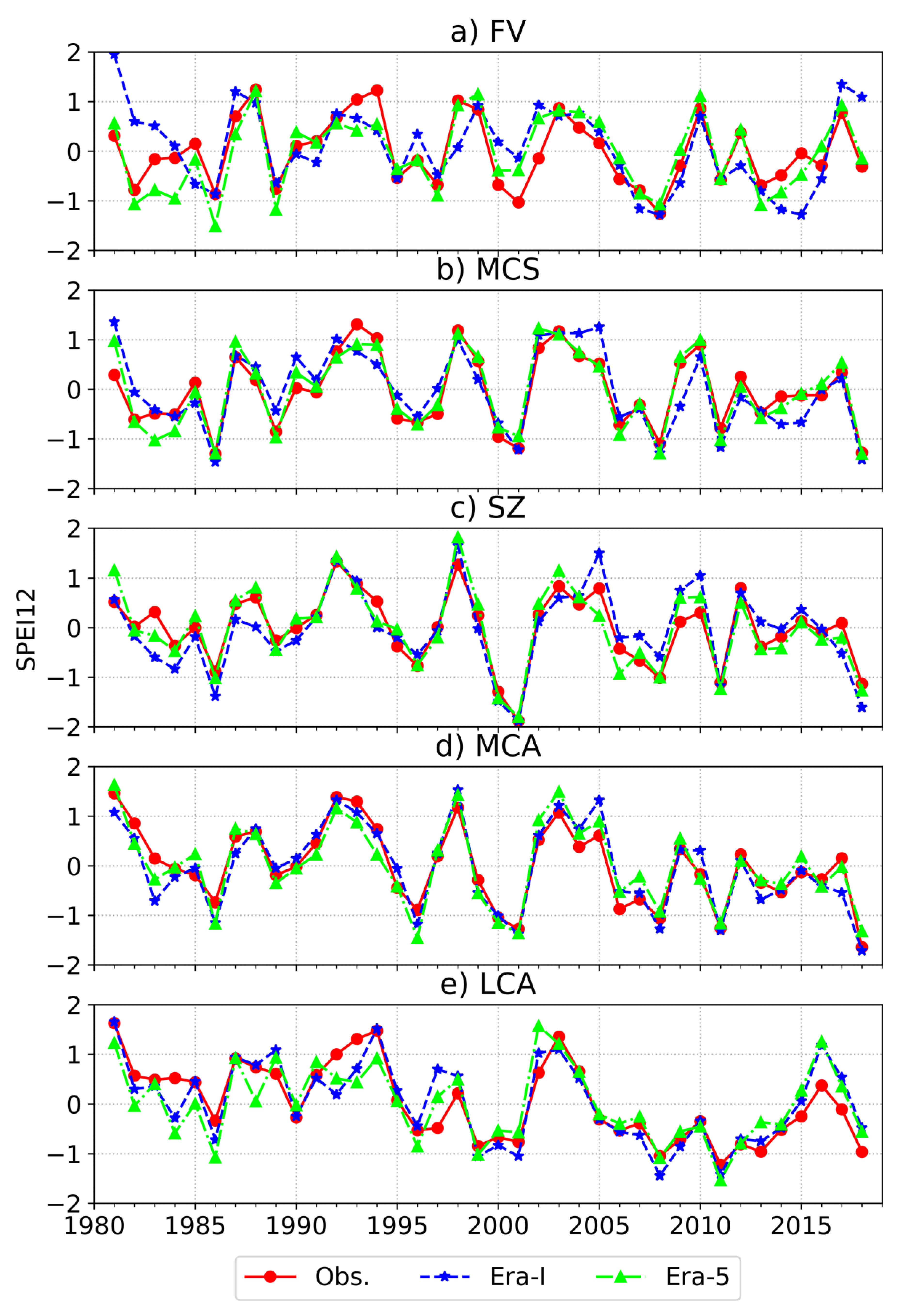
SPEI was calculated for the five defined regions using ground observations, ERA-I, and ERA-5, which are shown in Figure 8. The selected timescale of 12 months reflects the long-term precipitation anomalies. The SPEI values have identical patterns for all regions and well demonstrates the years of severe droughts for 2000–2001, 2008 and 2011 recorded and described in [6]. However, the SPEI from ERA-5 shows slightly better agreement with observations than from ERA-I, as correlation coefficients are 0.8 and 0.7, respectively. The large observation-reanalysis misfit in SPEI is found for positive values in the FV zone. Most likely, it is the result of including high-mountain stations, where the largest statistical error in precipitation is observed (Figure 4d).

3.4. Assessment of Variability of Meteorological Parameters for the Period 1981–2018

As shown above, ERA-5 reproduces well the temperature characteristics and their functions for the territory of Uzbekistan. Therefore, the use of this reanalysis to study climatic parameters and their trends for the specified region is acceptable and desirable. Along with an increase in average temperatures and moisture deficit, an increase in the duration of these events is noted. Figure 9 shows variation in the Number of days with VPD ≥ 50 and the Number of days with T m a x ≥ 40 parameters. The original period 1981–2018 was divided into two sub-periods 1981–2000 and 2000–2018. Here, the drought indices are determined independently for each grid and then averaged over the country. Since the 2000s, there has been a steep increase in the number of driest and hottest days, i.e., Number of days with T m a x ≥ 40 from 6.9 ± 2.4 in 1981–2000 to 9.2 ± 2.4 in 2000–2018. Even in such short time periods (18 years), the difference is significant, as the p-value of the T-test equals 0.015.
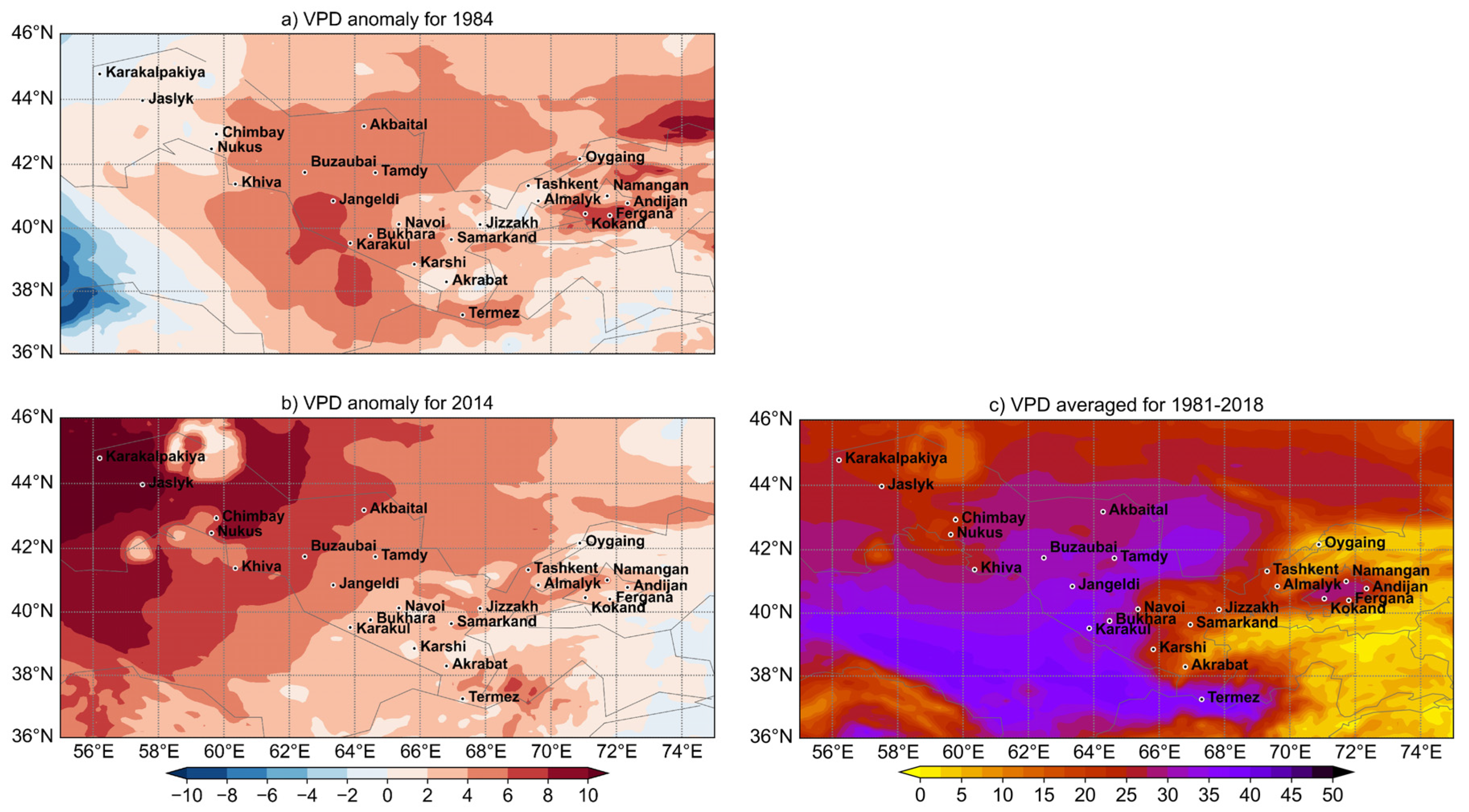
According to Figure 9, 1984 and 2014 stand out among hot and dry years, when the number of days with VPD ≥ 50 is much above the average for 1981–2018. Therefore, in Figure 10a,b, we show the distribution of VPD anomalies for August of 1984 and 2014 relative to the average value calculated for August 1981–2018 (Figure 10c). The maximum average values are found in the central and southern parts of Uzbekistan (Surkhandarya, Navoi, Jizzakh, and Khorezm regions); however, abnormally hot years can differ significantly in the VDP coverage. This suggests that it is also necessary to study local variability in addition to the average characteristics and long-term trends for the country. The mountainous regions to the east (including those outside Uzbekistan), where runoff formation zones are located, are of considerable interest.

4. Summary and Conclusions

In this study, meteorological observations at the ground stations were used to evaluate the performance of the near-surface air temperature, humidity, and precipitation obtained from two high-resolution reanalyses, ERA-I and ERA-5, over Uzbekistan from 1981 to 2018. Comparisons by several statistical measures showed that these datasets are fairly accurate in describing the meteorological parameter variations in the region of study, although minor differences exist. We conclude that ERA-5 reanalysis is much improved compared to ERA-I in foothills and mountain zones of Uzbekistan. Due to the high resolution in time and space, even the precipitation field displays a high agreement with observations. Therefore, for the standardized precipitation evapotranspiration index (SPEI) calculated from ground observations, ERA-I, and ERA-5 show a high level of agreement with a correlation coefficient of 0.7–0.8.
The results also show that ERA-5 climatological biases in temperature and precipitation are nearly constant and can be corrected. Temperature characteristics show better agreement with observations than relative and absolute humidity. No improvements are found in the representation of humidity in the ERA-5 product. Based on this, it is preferable to use temperature characteristics from reanalysis for the calculation of drought indices.
Comparison of the calculated data with the Cadastre data using the parameter “Number of days with VPD ≥ 50” for 34 stations showed satisfactory agreement (average values for Uzbekistan ± 1 day, correlation coefficient—0.73). On average, the number of days with atmospheric drought in the Surkhandarya region reaches 75, Bukhara reaches 55, Navoi reaches 50, and Kashkadarya reaches 25. The spatial distribution of the average VPD (1981–2018), built according to the ERA-5 reanalysis, showed that maximum values of 30–40 hPa are regularly observed practically throughout the entire central and southern parts of Uzbekistan (Surkhandarya, Navoi, Jizzakh and Khorezm regions). In addition, anomalies for August 1984 and 2014 were analyzed. On the example of these dry years with practically the same values of the parameter “Number of days with VPD ≥ 50,” noticeable differences in spatial coverage and intensity were revealed. Therefore, along with the assessment of average characteristics and trends, it is necessary to study local variability, including mountainous areas on the eastern border and outside of Uzbekistan, where flow formation zones are located.
Although both of these ECMWF products show comparable performance, the newer, advanced, and actively developed ERA-5 is preferred. Since the results of the work were obtained for various regions of Uzbekistan, we believe that they can be generalized to broader regions of Central Asia.

Author Contributions

Conceptualization, M.A.; Formal analysis, N.R.; Methodology, M.A.; Project administration, B.N., R.T. and D.A.B.; Software, V.R.; Supervision, M.A., B.N. and R.T.; Validation, N.R. and L.S.; Visualization, N.R., V.R. and D.A.B.; Writing–original draft, N.R., L.S. and B.N.; Writing–review & editing, N.R., M.A., L.S., R.T., V.R. and D.A.B. All authors have read and agreed to the published version of the manuscript.

Funding

This research received no external funding.

Institutional Review Board Statement

Not applicable.

Informed Consent Statement

Not applicable.

Data Availability Statement

ERA-Interim and ERA5 datasets were downloaded from European Centre for Medium-Range Weather Forecasts (http://apps.ecmwf.int/datasets/data/interim-full-daily/levtype=sfc/ (accessed on 20 April 2021)) and (https://cds.climate.copernicus.eu/cdsapp#!/dataset/reanalysis-era5-land?tab=form (accessed on 20 April 2021)), respectively.

Acknowledgments

We acknowledge the ECMWF for the production of the reanalysis data used in this research.

Conflicts of Interest

The authors declare no conflict of interest.

References

  1. World Meteorological Organization. Drought Monitoring and Early Warning: Concepts, Progress and Future Challenges; World Meteorological Organization: Geneva, Switzerland, 2006. [Google Scholar]
  2. IPCC. Climate Change 2014: Synthesis Report. Contribution of Working Groups I, II and III to the Fifth Assessment Report of the Intergovernmental Panel on Climate Change; IPCC: Geneva, Switzerland, 2014. [Google Scholar]
  3. Liu, Y.; Geng, X.; Hao, Z.; Zheng, J. Changes in Climate Extremes in Central Asia under 1.5 and 2 ºC Global Warming and their Impacts on Agricultural Productions. Atmosphere 2020, 11, 1076. [Google Scholar] [CrossRef]
  4. Pollner, J.; Kryspin-Watson, J.; Nieuwejaar, S. Disaster Risk Management and Climate Change Adaptation in Europe and Central Asia; World Bank: Washington, DC, USA, 2010. [Google Scholar]
  5. Uzbekistan Climate Change and Agriculture Country Note Climate Change Exposure and Risk for Uzbekistan 2010. Available online: www.worldbank.org/eca/climateandagriculture (accessed on 21 December 2020).
  6. Third National Communication of the Republic of Uzbekistan under the UN Framework Convention on Climate Change. PREPARED in the Framework of Project GEF/UNEP/Uzhydromet ‘Uzbekistan: Preparation of the Third National Communication of the Republic of Uzbekistan under the UN Framework Convention on Climate Change, Tashkent, 2016. Available online: https://unfccc.int/sites/default/files/resource/TNC of Uzbekistan under UNFCCC_english_n.pdf (accessed on 21 December 2020).
  7. Chub, V.E. Climate Change and Its Impact on Hydrometeorological Processes, Agroclimatic and Water Resources of the Republic of Uzbekistan; Uzhydromet: Tashkent, Uzbekistan, 2007. (in Russian) [Google Scholar]
  8. IPCC. IPCC Special Report on the Impacts of Global Warming of 1.5 °C; IPCC: Geneva, Switzerland, 2018. [Google Scholar]
  9. Sutton, W.R.; Srivastava, J.P.; Neumann, J.E.; Droogers, P.; Boehlert, B. Reducing the Vulnerability of Uzbekistan’s Agricultural Systems to Climate Change: Impact Assessment and Adaption Options; World Bank: Washington, DC, USA, 2013. [Google Scholar]
  10. Hersbach, H.; Bell, B.; Berrisford, P.; Hirahara, S.; Horányi, A.; Muñoz-Sabater, J.; Nicolas, J.; Peubey, C.; Radu, R.; Schepers, D.; et al. The ERA5 global reanalysis. Q. J. R. Meteorol. Soc. 2020, 146, 1999–2049. [Google Scholar] [CrossRef]
  11. Dee, D.P.; Uppala, S.M.; Simmons, A.J.; Berrisford, P.; Poli, P.; Kobayashi, S.; Andrae, U.; Balmaseda, M.A.; Balsamo, G.; Bauer, P.; et al. The ERA-Interim reanalysis: Configuration and performance of the data assimilation system. Q. J. R. Meteorol. Soc. 2011, 137, 553–597. [Google Scholar] [CrossRef]
  12. Bergman, J.W.; Fierli, F.; Jensen, E.J.; Honomichl, S.; Pan, L.L. Boundary layer sources for the Asian anticyclone: Regional contributions to a vertical conduit. J. Geophys. Res. Atmos. 2013, 118, 2560–2575. [Google Scholar] [CrossRef]
  13. Decker, M.; Brunke, M.A.; Wang, Z.; Sakaguchi, K.; Zeng, X.; Bosilovich, M.G. Evaluation of the Reanalysis Products from GSFC, NCEP, and ECMWF Using Flux Tower Observations. J. Clim. 2012, 25, 1916–1944. [Google Scholar] [CrossRef]
  14. Simmons, A.J.; Jones, P.D.; Bechtold, V.D.C.; Beljaars, A.C.M.; Kållberg, P.W.; Saarinen, S.; Uppala, S.M.; Viterbo, P.; Wedi, N. Comparison of trends and low-frequency variability in CRU, ERA-40, and NCEP/NCAR analyses of surface air temperature. J. Geophys. Res. Space Phys. 2004, 109. [Google Scholar] [CrossRef]
  15. Lindsay, R.; Wensnahan, M.; Schweiger, A.; Zhang, J. Evaluation of Seven Different Atmospheric Reanalysis Products in the Arctic. J. Clim. 2014, 27, 2588–2606. [Google Scholar] [CrossRef] [Green Version]
  16. Luo, H.; Ge, F.; Yang, K.; Zhu, S.; Peng, T.; Cai, W.; Liu, X.; Tang, W. Assessment of ECMWF reanalysis data in complex terrain: Can the CERA-20C and ERA-Interim data sets replicate the variation in surface air temperatures over Sichuan, China? Int. J. Clim. 2019, 39, 5619–5634. [Google Scholar] [CrossRef]
  17. Martins, D.S.; Paredes, P.; Raziei, T.; Pires, C.; Cadima, J.; Pereira, L.S. Assessing reference evapotranspiration estimation from reanalysis weather products. An application to the Iberian Peninsula. Int. J. Clim. 2017, 37, 2378–2397. [Google Scholar] [CrossRef]
  18. Jiang, J.; Zhou, T.; Zhang, W. Evaluation of Satellite and Reanalysis Precipitable Water Vapor Data Sets Against Radiosonde Observations in Central Asia. Earth Space Sci. 2019, 6, 1129–1148. [Google Scholar] [CrossRef] [Green Version]
  19. Kalnay, E. The NCEP_NCAR 40-year reanalysis project. 1996.pdf. Bull. Am. Meteorol. Soc. 1996, 77, 437–472. [Google Scholar] [CrossRef] [Green Version]
  20. Kanamitsu, M.; Ebisuzaki, W.; Woollen, J.; Yang, S.-K.; Hnilo, J.J.; Fiorino, M.; Potter, G.L. NCEP–DOE AMIP-II Reanalysis (R-2). Bull. Am. Meteorol. Soc. 2002, 83, 1631–1644. [Google Scholar] [CrossRef]
  21. Saha, S.; Moorthi, S.; Pan, H.-L.; Wu, X.; Wang, J.; Nadiga, S.; Tripp, P.; Kistler, R.; Woollen, J.; Behringer, D.; et al. The NCEP Climate Forecast System Reanalysis. Bull. Am. Meteorol. Soc. 2010, 91, 1015–1058. [Google Scholar] [CrossRef]
  22. Harada, Y.; Kamahori, H.; Kobayashi, C.; Endo, H.; Kobayashi, S.; Ota, Y.; Onoda, H.; Onogi, K.; Miyaoka, K.; Takahashi, K. The JRA-55 Reanalysis: Representation of Atmospheric Circulation and Climate Variability. J. Meteorol. Soc. Jpn. 2016, 94, 269–302. [Google Scholar] [CrossRef] [Green Version]
  23. Kobayashi, S.; Ota, Y.; Harada, Y.; Ebita, A.; Moriya, M.; Onoda, H.; Onogi, K.; Kamahori, H.; Kobayashi, C.; Endo, H.; et al. The JRA-55 Reanalysis: General Specifications and Basic Characteristics. J. Meteorol. Soc. Jpn. 2015, 93, 5–48. [Google Scholar] [CrossRef] [Green Version]
  24. Rienecker, M.M.; Suarez, M.J.; Gelaro, R.; Todling, R.; Bacmeister, J.; Liu, E.; Bosilovich, M.G.; Schubert, S.D.; Takacs, L.; Kim, G.-K.; et al. MERRA: NASA’s Modern-era retrospective analysis for research and applications. J. Clim. 2011, 24, 3624–3648. [Google Scholar] [CrossRef]
  25. Gelaro, R.; Mccarty, W.; Suárez, M.J.; Todling, R.; Molod, A.; Takacs, L.; Randles, C.A.; Darmenov, A.; Bosilovich, M.G.; Reichle, R.; et al. The Modern-Era Retrospective Analysis for Research and Applications, Version 2 (MERRA-2). J. Clim. 2017, 30, 5419–5454. [Google Scholar] [CrossRef] [PubMed]
  26. Hu, Z.; Zhang, C.; Hu, Q.; Tian, H. Temperature Changes in Central Asia from 1979 to 2011 Based on Multiple Datasets. J. Clim. 2014, 27, 1143–1167. [Google Scholar] [CrossRef]
  27. Mamadjanova, G.; Wild, S.; Walz, M.A.; Leckebusch, G.C. The role of synoptic processes in mudflow formation in the piedmont areas of Uzbekistan. Nat. Hazards Earth Syst. Sci. 2018, 18, 2893–2919. [Google Scholar] [CrossRef] [Green Version]
  28. Lioubimtseva, E. Arid environments. In Physical Geography of Northern Eurasia; Shahgedanova, M., Ed.; Oxford University Press: Oxford, UK, 2002; pp. 267–283. [Google Scholar]
  29. Khamzina, T.; Khasankhanova, G.; Denisova, E.; Ibragimov, R. Climate Change Vulnerability Assessment of Agriculture and Water Resources in Uzbekistan to Inform Decision-Making; Uzhydromet: Tashkent, Uzbekistan, 2021. (in Russian) [Google Scholar]
  30. Regional report #3 Draft regional policy, strategy, and action program for water and salt management. In Water and Environmental Management Project i Sub-Component A1; Royal Haskoning: Amersfoort, The Netherlands, 2003.
  31. Simmons, A.; Uppala, S.; Dee, D.; Kobayashi, S. ERA-Interim: New ECMWF reanalysis products from 1989 onwards. ECMWF Newsl. 2007, 110, 25–36. [Google Scholar]
  32. Available online: https://confluence.ecmwf.int/display/CKB/ERA5%3A+data+documentation (accessed on 20 April 2021).
  33. Hersbach, H. Global reanalysis: Goodbye ERA-Interim, hello ERA5. ECMWF Newsl. 2019, 159, 17–24. [Google Scholar]
  34. Babushkin, L.N. Regarding climatic characteristics of summer atmospheric drought and hot dry winds in the cotton region of Uzbekistan. In Hot Dry Winds, Their Origin and Control; SANIGMI: Tashkent, Uzbekistan, 1974; pp. 59–64. (in Russian) [Google Scholar]
  35. Vicente-Serrano, S.M.; Beguería, S.; López-Moreno, J.I. A Multiscalar Drought Index Sensitive to Global Warming: The Standardized Precipitation Evapotranspiration Index. J. Clim. 2010, 23, 1696–1718. [Google Scholar] [CrossRef] [Green Version]
  36. Beguería, S.; Vicente-Serrano, S.M.; Reig-Gracia, F.; Latorre, B. Standardized precipitation evapotranspiration index (SPEI) revisited: Parameter fitting, evapotranspiration models, tools, datasets and drought monitoring. Int. J. Clim. 2014, 34, 3001–3023. [Google Scholar] [CrossRef] [Green Version]
  37. Hargreaves, G.H. Defining and Using Reference Evapotranspiration. J. Irrig. Drain. Eng. 1994, 120, 1132–1139. [Google Scholar] [CrossRef]
  38. Droogers, P.; Allen, R.G. Estimating Reference Evapotranspiration under Inaccurate Data Conditions. Irrig. Drain. Syst. 2002, 16, 33–45. [Google Scholar] [CrossRef]
  39. Yuan, W.; Zheng, Y.; Piao, S.; Ciais, P.; Lombardozzi, D.; Wang, Y.; Ryu, Y.; Chen, G.; Dong, W.; Hu, Z.; et al. Increased atmospheric vapor pressure deficit reduces global vegetation growth. Sci. Adv. 2019, 5, eaax1396. [Google Scholar] [CrossRef] [Green Version]
  40. Konings, A.G.; Williams, A.P.; Gentine, P. Sensitivity of grassland productivity to aridity controlled by stomatal and xylem regulation. Nat. Geosci. 2017, 10, 284–288. [Google Scholar] [CrossRef]
  41. Restaino, C.M.; Peterson, D.L.; Littell, J. Increased water deficit decreases Douglas fir growth throughout western US forests. Proc. Natl. Acad. Sci. USA 2016, 113, 9557–9562. [Google Scholar] [CrossRef] [Green Version]
  42. Lobell, D.B.; Roberts, M.J.; Schlenker, W.; Braun, N.; Little, B.B.; Rejesus, R.M.; Hammer, G.L. Greater Sensitivity to Drought Accompanies Maize Yield Increase in the U.S. Midwest. Science 2014, 344, 516–519. [Google Scholar] [CrossRef] [PubMed]
  43. Alduchov, O.A.; Eskridge, R.E. Improved Magnus form approximation of saturation vapor pressure. J. Appl. Meteorol. 1996. [Google Scholar] [CrossRef]
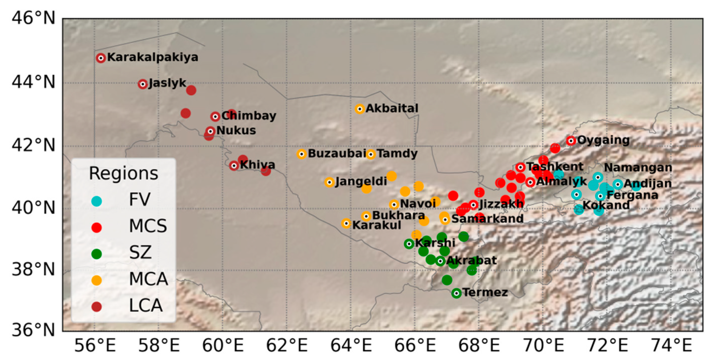
Figure 1. The map of the study domain. Color symbols represent the observation site locations by regions defined in Table 1. Major cities of Uzbekistan are marked by black dots with labels.
Atmosphere 12 00527 g001
Figure 2. Comparative diagrams for mean monthly temperature (a,b), maximum monthly temperature (c,d), relative humidity (e,f), absolute humidity (g,h), and precipitation (i,j) derived at coordinates of meteorological stations for the period January–December 1981–2018.
Atmosphere 12 00527 g002
Figure 3. The difference in mean (a,b) and averaged maximum (c,d) temperatures, and averaged precipitation (e,f), relative (g,h) and absolute (i,j) humidity between ERA-5, ERA-I, and observations over 74 meteorological stations of Uzbekistan averaged over administrative provinces (left panels) and regions (right panels).
Atmosphere 12 00527 g003
Figure 4. Change in observed (a) average temperature, (b) precipitation as well as the misfit in (c) average temperature and (d) precipitation for the period 1981–2018. The dashed line is for observations, and the line with symbols represents ΔT = Tobs − TERA-5, while the solid line is for ΔT = Tobs − TERA-I calculated over 74 meteorological stations and averaged for the defined regions of Uzbekistan.
Atmosphere 12 00527 g004
Figure 5. Spatial distribution of average temperature for August 1981–2018 from (a) ERA-I and (b) ERA-5.
Atmosphere 12 00527 g005
Figure 6. Spatial distribution of average precipitation for August 1981–2018 from (a) ERA-I and (b) ERA-5.
Atmosphere 12 00527 g006
Figure 7. Distribution of the average number of days with VDP ≥ 50 hPa, according to ERA-5 data for May–September 2005–2018.
Atmosphere 12 00527 g007
Figure 8. Evolution of the 12-month SPEI calculated over 74 meteorological stations and averaged for the defined regions of Uzbekistan: (a) FV, (b) MCS, (c) SZ, (d) MCA, and (e) LCA.
Atmosphere 12 00527 g008
Figure 9. The average number of days per year with (a) VDP ≥ 50 hPa and (b) T m a x ≥ 40 °C for the period 1981–2018. The dashed red and magenta lines represent mean values for 1981–2000 and 2000–2018, respectively. The solid black and red lines are the linear trend for 1981–2018 and 2000–2018, respectively.
Atmosphere 12 00527 g009
Figure 10. Anomaly VPD for August of 1984 (a) and 2014 (b), calculated with respect to the averaged value for August of 1981–2018 shown at the panel (c).
Atmosphere 12 00527 g010
Table 1. Administrative provinces and defined regions of the territory of Uzbekistan [6].
#RegionsAdministrative ProvincesRiver Basin
1FVAndijan, Namangan, FerganaSyrdarya
2MCSJizzakh, Syrdarya, Tashkent
3SZKashkadarya, SurkhandaryaAmudarya
4MCABukhara, Navoi, Samarkand
5LCAKarakalpakstan, Khorezm
Table 2. Mean and standard deviation values of parameters from instrumental observations and reanalyses for the period January–December 1980–2018.
ParameterMeanSD
Obs.ERA-IERA-5Obs.ERA-IERA-5
T, °C13.5411.9612.9210.3810.3010.93
Tmax, °C27.9124.7725.8710.2910.2410.92
RH, %58.3658.2754.6415.9615.1715.28
SH, g/kg7.605.725.353.432.312.10
TP, mm27.8917.0720.6536.7218.5523.54
Table 3. Estimation of discrepancies between reanalysis and instrumental observation data for the period January–December 1980–2018. The mean error is defined as the difference between reanalysis and observations.
ParameterCorrelationMean ErrorSD
ERA-IERA-5ERA-IERA-5ERA-IERA-5
Δ T, °C0.970.98−1.57−0.622.602.25
Δ Tmax, °C0.950.96−3.14−2.043.372.98
Δ RH, %0.850.87−0.08−3.729.579.60
Δ SH, g/kg0.850.88−1.88−2.241.881.88
Δ TP, mm0.560.80−10.82−7.2430.3922.61
Table 4. Indicators of atmospheric drought (VPD, hPa).
VPD, hPa50–6060–7070–80>80
Drought strengthweakmediumstrongvery strong
Table 5. Statistical analysis for the indicator, Number of days, with VDP ≥50 hPa.
ParameterNumber of SitesMean Number, DaysCorrelation Coefficient (Inventory—ERA-5)
CadastreERA-5
Number of days with VDP ≥50 hPa3427.9728.460.73
Publisher’s Note: MDPI stays neutral with regard to jurisdictional claims in published maps and institutional affiliations.