Article

Performance Assessment of GSMaP and GPM IMERG Products during Typhoon Mangkhut

1
Key Laboratory of Environment Change and Resources Use in Beibu Gulf, Ministry of Education, Nanning Normal University, Nanning 530001, China
2
School of Geographic Sciences and Planning, Nanning Normal University, Nanning 530001, China
3
Key Laboratory of Tropical Atmosphere-Ocean System, School of Atmospheric Sciences, Sun Yat-Sen University, Zhuhai 519000, China
4
Southern Laboratory of Ocean Science and Engineering, Zhuhai 519000, China
5
Guangdong Province Key Laboratory for Climate Change and Natural Disaster Studies, Sun Yat-Sen University, Zhuhai 519000, China
*
Author to whom correspondence should be addressed.
Atmosphere 2021, 12(2), 134; https://doi.org/10.3390/atmos12020134
Submission received: 24 December 2020 / Revised: 12 January 2021 / Accepted: 14 January 2021 / Published: 21 January 2021

Abstract

:
This paper evaluated the latest version 6.0 Global Satellite Mapping of Precipitation (GSMaP) and version 6.0 Integrated Multi-satellitE Retrievals for Global Precipitation Measurement (IMERG) products during 2018 Typhoon Mangkhut in China. The reference data is the rain gauge datasets from Gauge-Calibrated Climate Prediction Centre (CPC) Morphing Technique (CMORPHGC). The products for comparison include the GSMaP near-real-time, Microwave-IR merged, and gauge-calibrated (GSMaP_NRT, GSMaP_MVK, and GSMaP_Gauge) and the IMERG Early, Final, and Final gauge-calibrated (IMERG_ERUncal, IMERG_FRUncal, and IMERG_FRCal) products. The results show that (1) both GSMaP_Gauge and IMERG_FRCal considerably reduced the bias of their satellite-only products. GSMaP_Gauge outperforms IMERG_FRCal with higher Correlation Coefficient (CC) values of about 0.85, 0.78, and 0.50; lower Fractional Standard Error (FSE) values of about 18.00, 18.85, and 29.30; and Root-Mean-Squared Error (RMSE) values of about 12.12, 33.35, and 32.99 mm in the rainfall centers over mainland China, southern China, and eastern China, respectively. (2) GSMaP products perform better than IMERG products, with higher Probability of Detection (POD) and Critical Success Index (CSI) and lower False Alarm Ratio (FAR) in detecting rainfall occurrence, especially for high rainfall rates. (3) For area-mean rainfall, IMERG performs worse than GSMaP in the rainfall centers over mainland China and southern China but shows better performance in the rainfall center over eastern China. GSMaP_Gauge and IMERG_FRCal perform well in the three regions with a high CC (0.79 vs. 0.94, 0.81 vs. 0.96, and 0.95 vs. 0.97) and a low RMSE (0.04 vs. 0.06, 0.40 vs. 0.59, and 0.19 vs. 0.34 mm). These useful findings will help algorithm developers and data users to better understand the performance of GSMaP and IMERG products during typhoon precipitation events.

1. Introduction

With a maximum wind speed of about 270 km/h, typhoon Mangkhut became the most destructive typhoon in Asia in 2018. It formed on 7 September 2018 as a tropical depression, gradually intensified as a super typhoon on 15 September 2018, and landed in Cagayan, Philippines. After its span in Philippines, the South China Sea helped the weakened typhoon Mangkhut gather more energy and caused its second landfall in Jiangmen, China on 16 September 2018. Compared to common tropical cyclones (TCs), typhoon Mangkhut not only had a stronger storm intensity with larger forward speed but also had a larger size with a diameter of more than 1000 km. As a result, the storm surge was higher, the affected inland area was larger, and the flooding duration also lasted longer. Typhoon Mangkhut also caused excessive rainfall in southern China and even brought heavy rainstorms to the far east of Jiangsu, Zhejiang, and Shanghai, China [1,2,3]. Therefore, it is too difficult to observe such a strong TC weather system in detail with conventional gauges, ground weather radars, and raindrop spectra.
As remote sensing technology develops rapidly, these satellite-based Quantitative Precipitation Estimates (QPE) products become significant rainfall products and they can provide continuously high-resolution observations of precipitation over regional and global scales with their dramatically increased spatial and temporal resolution in recent years. Operating in the sky above the Earth, these satellites avoid the harmful effects of severe weather and complex terrain and were propitious to full land-ocean coverage and all-weather observation, which attracts widespread attention [4]. At present, the Precipitation Estimation from Remotely Sensed Information using Artificial Neural Networks (PERSIANN) [5] and the later PERSIANN-Cloud Classification System (PERSIANN-CCS) [6], the Climate Prediction Center (CPC) morphing method (CMOPRH) [7], the Integrated Multi-satellitE Retrievals for Global Precipitation Measurement (IMERG) [8], and the Global Satellite Mapping of Precipitation (GSMaP) [9] are widely used satellite-based QPE products. Based on the successful launch of Tropical Rainfall Measuring Mission (TRMM) in 1997, these satellite products have been popularized for precipitation-related research applications in hydrology, meteorology, climate change, hazards monitoring, and agriculture [10,11,12,13,14,15]. The satellite quantitative precipitation entered the era of the Global Precipitation Measurement program (GPM) since the TRMM officially retired in 2015. The National Aeronautics and Space Administration (NASA) and the Japan Aerospace Exploration Agency (JAXA) developed the GPM together to further improve the accuracy of the QPE, aiming for greater area coverage than the TRMM [16]. The GPM includes the Dual-frequency Precipitation Radar (DPR) and GPM Microwave Imager (GMI). The DPR is the first space-borne dual-frequency phased array precipitation radar to observe the internal structure of storms within and under the clouds, while the GMI has the conical-scanning multi-channel to physically measure the intensity, type, and size of the precipitation [17]. The new generation of satellite precipitation products of IMERG make use of the merits of PERSIANN-CSS, CMOPRH, and TRMM Multi-satellite Precipitation Analysis (TMPA) [18]. Both IMERG and GSMaP are multi-satellite rainfall products with a combination of infrared (IR) algorithms and passive microwave (PMW) algorithms. This merged PMW–IR information enhances the respective advantages of separate PMW or IR satellite-based rainfall estimates. Additionally, the IR satellite estimates can be adjusted with the improved accuracy of PMW data, while the PMW satellite estimates can be interpolated based on cloud motions obtained from the high IR data sampling rate [19,20,21,22].
Although conventional rain gauges were selected for ground reference in many previous verification studies, various errors of rain gauges such as wind effect bias, evaporation, and other sources of deficiencies cannot be ignored. Traditional rain gauge networks can provide highly accurate rainfall measurements at specific locations, but in many cases, these instruments are too scarce to accurately identify the spatiotemporal variability of precipitation systems [23,24]. The object of this study is to evaluate and compare the performance of GSMaP and IMERG during the high-impact typhoon Mangkhut. The reference data are rain gauge data from the gauge-satellite merged product CMORPHGC without limitations in spatial coverage over China. The paper is organized as follows: Section 2 describes the study area and available rainfall products to be evaluated for typhoon Mangkhut. Section 3 provides an analysis of the spatial and temporal characteristics and error quantification for the rainfall brought by typhoon Mangkhut to mainland China from 01:00 AM on 15 September 2018 to 00:00 AM on 18 September 2018 at local standard time. Section 4 gives a summary of the analysis results.

2. Study Area and Data

2.1. Study Area

Mainland China covers a total land area of about 9.63 million km2, with an elevation ranging from −152 to 8752 m, bounded by 18° N–55° N latitude and 73° E–136° E longitude. Figure 1a shows the terrain of mainland China and the tracks of typhoon Mangkhut. The terrain is characterized by a westward high elevation and an eastward low slope to the ocean, which is conducive to moist air currents over the ocean that penetrate deep into the inland region and form precipitation. Eastern China is a monsoon climate zone, while the northwest, far from the sea, is a non-monsoon zone with a temperate continental climate. Over southeastern and southern China, subtropical monsoons coupled with orographic effects from complex terrain usually cause substantial precipitation [25]. Moreover, the monsoon which moves back and forth between the Siberia Mongolian Plateau and the Pacific Ocean has a primary influence on the climate of southeastern and southern China, and its seasonal propagation contributes to the formation of typhoons in the western Pacific Ocean and their landfall in southeastern and southern China [26]. Furthermore, the annual distribution of precipitation in southern China is uneven, with July to September dominated by TC-generated precipitation [27]. TCs not only lead to economic losses but also cause natural disasters such as heavy rainfall, urban flooding, and landslides.

2.2. Rainfall Datasets

2.2.1. Gauge Precipitation Observation

In this paper, we used CMORPHGC precipitation products [28] initiated by the National Meteorological Information Center of China as a reference to evaluate the GSMaP and IMERG products. CMORPHGC is comprised of historical combined precipitation data at 0.1° × 0.1° resolution per hour in China, employing the improved probability density function–optimal interpolation (Impr_PDF-OI) algorithm to first correct the 8 km/30 min CMORPH and then to merge the bias-corrected CMORPH with hourly precipitation observations from over 30,000 automatic weather stations (AWS) in China. The cross-validation results indicate that CMORPHGC has a tiny random error with a low mean root-mean-squared Error (0.594 mm/h), a small systematic bias (−0.002 mm/h), and a high correlation coefficient (0.8) between itself and the gauge analysis. This merged dataset effectively synthesizes the AWS observations and satellited products of CMORPH to provide more reasonable reference precipitation information, which is best on the precision and spatial and temporal resolution in China at present and can capture some varying features of hourly precipitation in heavy weather events very well. More details can be found in [28]. In particular, Chen et al. [29] investigated the precipitation spectra analysis over China with CMORPHGC, documenting well the geographical and seasonal variations in precipitation over seven subregions. Different from the rain gauge datasets used in that study [30,31,32], this paper only selects grid datasets that contain at least one rain gauge from CMORPHGC for calculation and quantitative comparison of the statistical indexes so that all the data used include observation data of AWS. Approximately 29,000 rain gauge observations are selected for this study (Figure 1b).

2.2.2. Satellite Precipitation

The main characteristics of the satellite-based algorithms used in this paper are shown in Table 1. GSMaP and IMERG are the precipitation products with the highest spatiotemporal resolution (0.1°/60 min and 0.1°/30 min respectively) among the current satellite precipitation products. The latest version 6.0 GSMaP (V6) available since September 2014 was used in this study. The GSMaP project was sponsored by the Japan Science and Technology Agency (JST) between 2002 and 2007 and later by the JAXA Precipitation Measuring Mission (PMM) Science Team since 2008. The GSMaP algorithm includes the GSMaP_NRT, GSMaP_MVK, and GSMaP_Gauge algorithms. GSMaP_NRT is available four hours after observation, while about 3 days after observation, GSMaP_MVK and GSMaP_Gauge are available. GSMaP_NRT applies to morph and Kalman filters only by the forward process. At the same time, GSMaP_MVK is obtained by cloud-top motion derived from two successive IR images and a Kalman filter by both the forward and backward propagation processes. GSMaP_Gauge adjusts the GSMaP_MVK estimate with a global daily gauge dataset supplied by the NOAA Climate Prediction Center (CPC). In addition, DPR was not directly used for developing the database or precipitation physical models while GMI was used as the inputs of GSMaP [22,33,34].
IMERG is the level-3 GPM precipitation estimation product that includes Early Run, Late Run and Final Run products. The Early Run and Late Run data are considered near-real-time products with a latency of about 4 h and 14 h, respectively. The Final Run is the post-real-time research product at about 3.5 months after observation time. Moreover, the Early Run provides relatively quick results for flood analysis and other short-fuse applications by only employing forward morphing. Both the forward and backward morphing schemes are used in the Late and Final Runs. The Late and Final Runs are expected to better describe changes in the intensity and shape of rainfall features. The Late Run is appropriate for daily and longer applications, such as crop forecasting. The Final Run is considered the research-grade product, providing multi-satellite precipitation estimates without gauge calibration (IMERG_FRUncal) as well as the calibrated estimates (IMERG_FRCal). For bias correction, climatological gauge data are used for the Early and Late Runs, while the IMERG_FRCal ingests monthly Global Precipitation Climatology Centre (GPCC) gauge analyses to calibrate the IMERG_FRUncal. The GPCC used two gauged analysis products in IMERG_FRCal such as the full data reanalysis (Version 2018) and GPCC monitoring product (Version 6). Firstly, the original half-hourly satellited-only estimates are summed for the calendar month. Secondly, the GPCC monthly precipitation gauge analysis is undercatch-corrected and is combined directly with the monthly gauge-adjusted satellited-only estimate by inverse error variance weighting. Thirdly, the half hourly multi-satellite estimates in the month are multiplied by the ratio between the monthly multi-satellite-only fields and satellite-gauge fields. Moreover, the calibrations are based on DPR and GMI and are applied in the IMERG processing [35,36].

2.3. Statistical Metrics

Seven commonly used skill scores like Root-Mean-Squared Error (RMSE), Fractional Standard Error (FSE), Relative Bias (RB), Correlation Coefficient (CC), Probability of Detection (POD), False Alarm Ratio (FAR), and Critical Success Index (CSI) are employed to assess the performance of the satellite-based precipitation products quantitatively. These metrics are defined in Table 2, while the number of hits (A), the false alarms (B), and the misses (C) are computed in Table 3 [27,37]. Taylor diagrams allow visualization and comparison of the overall performance between the QPE products and the gauge on CC, RMSE, and standard deviation. More detailed information on the Taylor diagram can be found in [38].

3. Results

3.1. Spatial Analysis

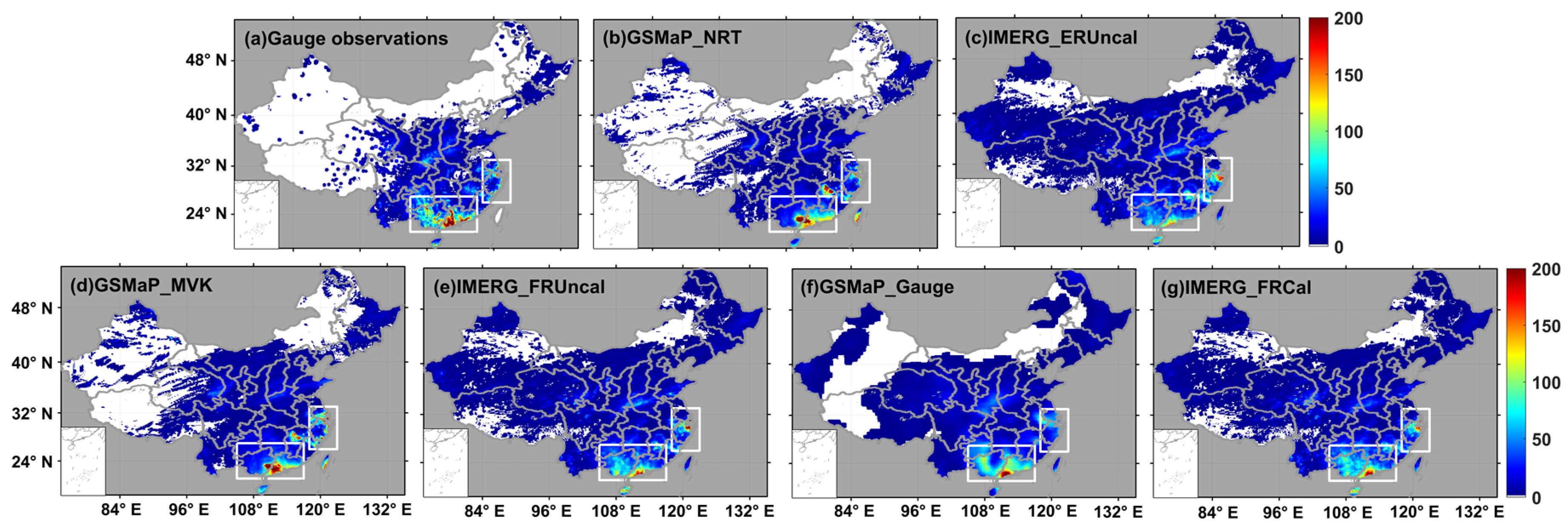
The spatial pattern of 72-h accumulated precipitation during typhoon Mangkhut is imaged in Figure 2. The accumulated precipitation over southern China (i.e., Guangdong and Guangxi province) is much higher than that over eastern China (i.e., Zhejiang and Jiangsu province) since the southern China rainfall center is triggered by typhoon Mangkhut while the eastern China rainfall center is triggered by an inverted typhoon trough. The inverted typhoon trough is mixed with cold air, and it is not like the typhoon itself, being full of warm and wet air. Therefore, the warm and humid air from the huge circulation of typhoon Mangkhut was transported to eastern China, where it gathered together with the cold air from the north, moving southward, causing heavy rain in a small area and for a short time in the region. More importantly, both the GSMaP and IMERG products can generally capture the spatial distribution of 72-h accumulated precipitation (Figure 2b–g), and the satellite-only precipitation products are not significantly different from their bias-adjusted products. Both GSMaP_Gauge and IMERG_FRCal better capture the spatial pattern of precipitation over mainland China, while the satellite-only products are not as good as the bias-corrected products. The satellite-only products slightly underestimated the precipitation in the rainfall center over southern China but showed overestimation in the rainfall center over eastern China. On top of that, the most impressive feature of GSMaP products is that the rainfall intensity closely resembles that of the gauge observations with much higher precipitation intensity than that of IMERG in the rainfall center over southern China. In comparison, the rainfall intensity is much lower than that of IMERG in the rainfall center over eastern China. This indicates that GSMaP performs better than IMERG. On the whole, the gauge correction algorithms applied in GSMaP_Gauge and IMERG_FRCal contribute more positive effects in southern China.
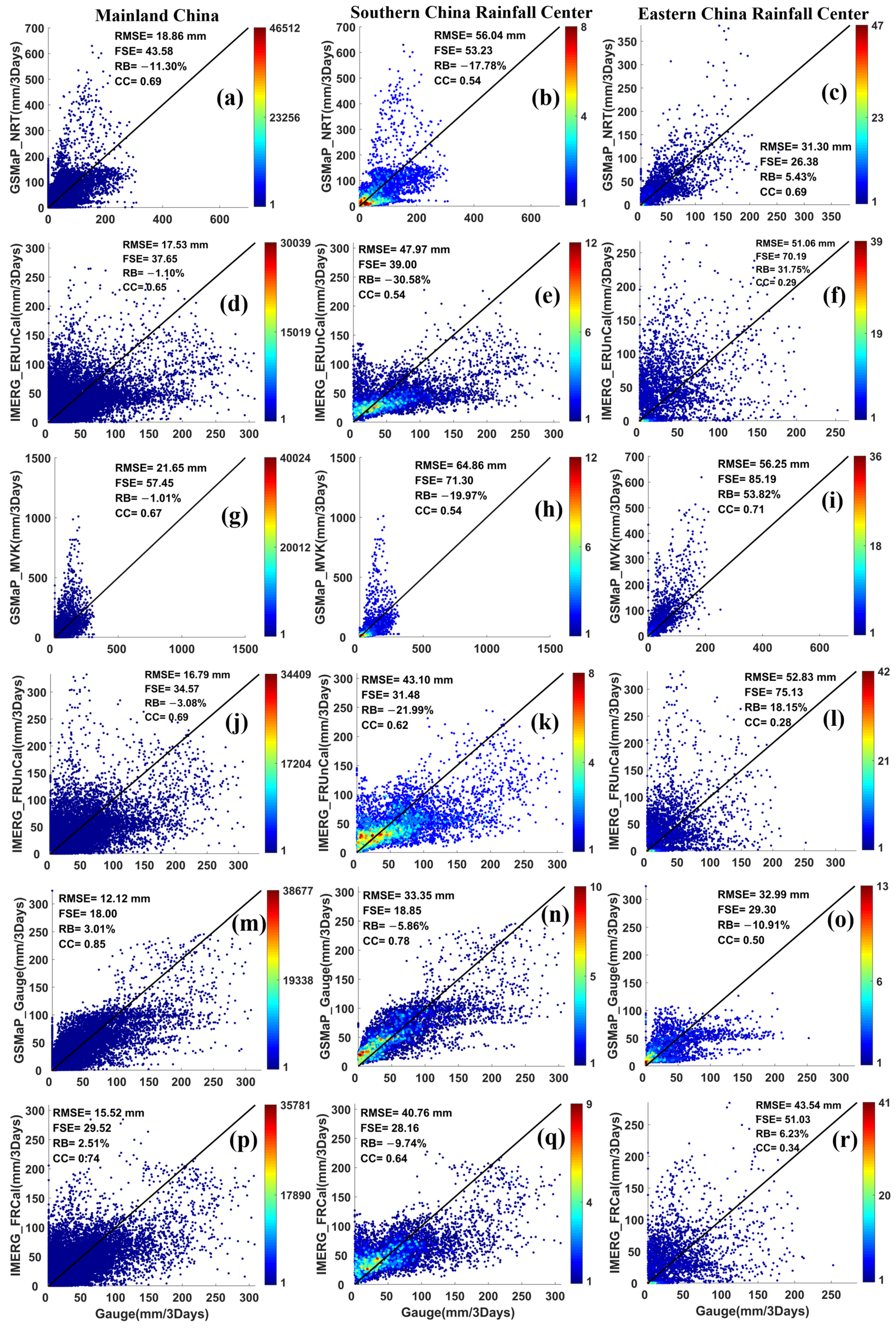
The scatter plots in Figure 3a–r provide a quantitative comparison of the satellite-based precipitation products (GSMaP and IMERG) versus gauge on accumulated precipitation during typhoon Mangkhut. The two bias-corrected products GSMaP_Gauge and IMERG_FRCal perform much better than the satellite-only estimates GSMaP_NRT and IMERG_ERUncal in the rainfall centers over mainland China and southern China, with increased CCs and reduced RMSEs, FSEs, and RBs. GSMaP_Gauge outperforms the IMERG_FRCal estimates in each region according to CCs (0.85 vs. 0.74, 0.78 vs. 0.64, and 0.50 vs. 0.34) and displays lower FSEs (18.00 vs. 29.52, 18.85 vs. 28.16, and 29.30 vs. 51.03) and RMSEs (12.12 vs. 15.52 mm, 33.35 vs. 40.76 mm, and 32.99 vs. 43.54 mm). Among satellite-only precipitation products, IMERG products have similar CCs to GSMaP products and have lower RMSEs and FSEs in rainfall centers over mainland China and southern China. In contrast, GSMaP products perform better than IMERG products, with higher CC over the rainfall center in eastern China. These statistics are slightly different from the spatial distribution of accumulated precipitation represented in Figure 2.
In order to determine which product more accurately estimates precipitation in these three regions, Figure 4 depicts the Taylor diagrams created by Taylor [38] to visually compare the statistics summary between individual satellite-based products and gauge data on CC, normalized standard deviation (SD), and RMSE. The position of each point that appears on the Taylor diagrams quantifies how well the satellite-based precipitation product matches the reference data, which is marked by a black star, and closer points denote better products. The gauge-corrected products have the distinct advantage of showing much closer distances than their satellite-only counterparts over the rainfall centers in mainland China and southern China. For the satellite-only products, the points of IMERG products are much closer to the gauge against GSMaP products over the rainfall centers in mainland China and southern China while the GSMaP products perform better over the rainfall centers in eastern China. These findings are consistent with the analysis of the scatter plots in Figure 3. GSMaP_MVK shows the most inferior performance in all regions, especially the rainfall center in southern China, with the highest SD and RMSE and relatively small CC. It is also found that IMERG_FRUncal outperforms other satellite-only products in the rainfall centers over mainland China and southern China. Over the rainfall center in eastern China, GSMaP_NRT performs best, with slightly better agreement than other satellite-based precipitation products. In addition, IMERG products have similar Taylor diagrams, with their close CCs and RMSEs, indicating that gauge-corrected IMERG_FRCal does not significantly improve the accuracy of uncalibrated data.

3.2. Contingency Scores

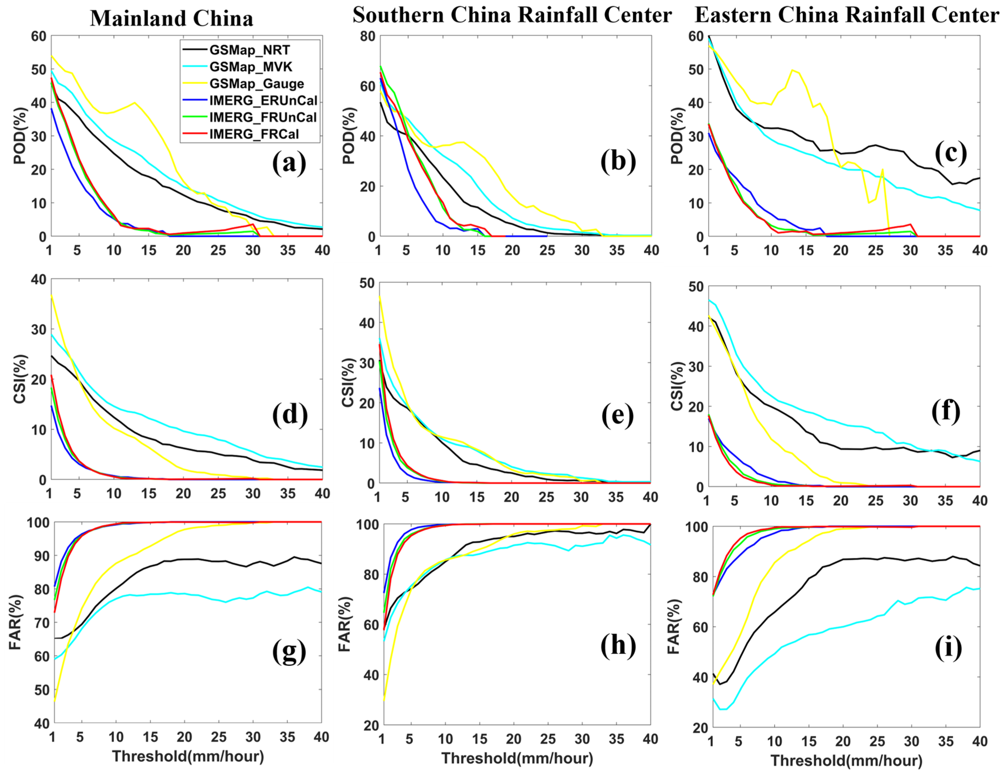
Probability of Detection (POD), False Alarm Ratio (FAR), and Critical Successful Index (CSI) can help us to examine the details of the nature of rainfall occurrence [39]. The contingency statistics (POD, CSI, and FAR) of the GSMaP and IMERG products as a function of hourly precipitation rate are depicted in Figure 5. As the threshold increases, there is the tendency for decreasing POD and CSI and increasing FAR for all products. Generally, GSMaP products have higher PODs and CSIs and lower FARs over various regions than IMERG products, especially for rainfall centers over mainland China and eastern China. Interestingly, IMERG products have relatively higher POD and lower CSI and FAR than GSMaP products for precipitation rates less than 5 mm/h over the rainfall center in southern China. However, all the IMERG products have very similar POD, CSI, and FAR, indicating that IMERG_FRCal fails to significantly improve the detection accuracy of precipitation events, which conforms to the Taylor diagram analysis in Figure 4. On the contrary, GSMaP_Gauge contributes better performance than its uncalibrated counterparts for the relatively higher POD and CSI and lower FAR when the rain rate is 1 mm/h. Regionally, POD and CSI were lower while FAR was higher for all products in the three regions when rain rates were greater than 5 mm/h. Interestingly, GSMaP_MVK exhibits higher CSI and lower FAR than its counterpart with bias correction for the precipitation rates greater than 5 mm/h over rainfall centers in mainland China and eastern China. IMERG_ERUncal represents the lowest POD and CSI and the highest FAR over rainfall centers in mainland China and southern China among all the products, while the percentage of POD and CSI (FAR) becomes higher (lower) over rainfall center in eastern China. This may indicate that rainfall intensity depends on contingency statistics (i.e., POD, CSI, and FAR).

3.3. Probability Distribution

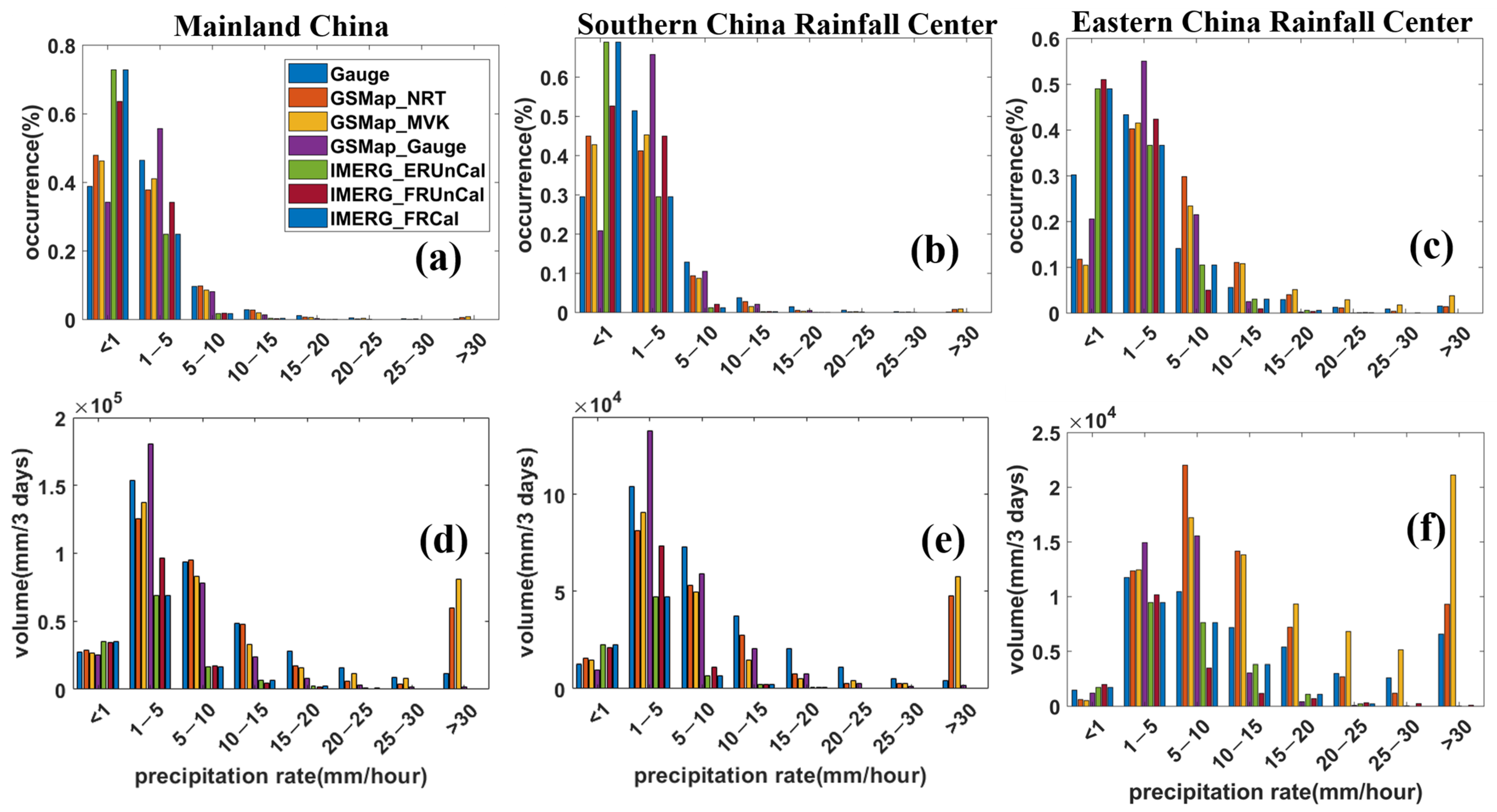
The Probability distribution functions (PDFs) reveal the inhomogeneity of precipitation in space and time and provide insights into the dependence of estimate errors on precipitation rate and the potential effects from these errors on hydrological applications [26]. Figure 6 depicts the PDFs of precipitation rates by occurrence (PDFc) and volume (PDFv) for gauge, GSMaP_NRT, GSMaP_MVK, GSMaP_Gauge, IMERG_ERUncal, IMERG_FRUncal, and IMERG_FRCal. All of the satellite-only precipitation products significantly overestimate the occurrence when rain rate is less than 1 mm/h (light precipitation) over rainfall centers in mainland China and southern China, while tending to underestimate the occurrence during 1 mm/h to 10 mm/h (moderate precipitation) over rainfall centers in mainland China and southern China. However, among the gauge-corrected products, GSMP_Gauge shows a relatively lower occurrence and IMERG_FRCal displays a higher occurrence when the precipitation rate is less than 1 mm/h. Interestingly, GSMaP_Gauge tends to overestimate rain rates while IMERG_FRCal underestimates rain rates at 1–5 mm/h in the three regions. As for rain volume, the GSMaP products, in parallel with IMERG, agrees well with the gauge when rain rate is less than 1 mm/h, but with a slightly lower PDFv during 10 mm/h to 30 mm/h over rainfall centers in mainland China and southern China. Furthermore, the IMERG products obviously underestimate the rain volume when the rain rate is more than 15 mm/h (heavy precipitation) in the three regions, implying that the IMERG products have difficulty in precisely estimating the heavy rainfall rates.

3.4. Mean Hourly Rainfall

The temporal variation of precipitation is critical to the hydrological cycle. Short periods of heavy rainfall can trigger floods, landslides, and other hydro-related disasters [40]. Figure 7 depicts the plots of the 72-h time series of area-mean hourly rainfall for all rainfall products over the three regions. In general, the GSMaP products (GSMaP_NRT, GSMaP_MVK, and GSMaP_Gauge) captured the closer performance of temporal variation of rainfall with the gauge in rainfall center over mainland China and southern China, with high CC (0.66 vs. 0.61, 0.80 vs. 0.68, and 0.79 vs. 0.81) and low RB (−0.11 vs. −0.18, −0.01 vs. −0.20, and 0.03 vs. −0.06). However, in the rainfall center over eastern China, IMERG products give better performance when capturing the time series area-averaged rainfall than the GSMaP products, with a more similar tendency to that of gauge. Additionally, the GSMaP_Gauge and IMERG_FRCal have a similar variation of hourly rainfall with gauge measurements when compared to their satellite-only products with a good match in the temporal variation of hourly rainfall over the three regions. All the gauge-adjusted products (GSMaP_Gauge and IMERG_FRCal) have a high CC (0.79 vs. 0.94, 0.81 vs. 0.96, and 0.95 vs. 0.97) and a low RMSE (0.04 vs. 0.06, 0.40 vs. 0.59, and 0.19 vs. 0.34mm) in the three regions.

4. Summary and Conclusions

This study evaluates the performances of the latest version 6.0 GSMaP and version 6.0 IMERG products in an extreme typhoon event (Mangkhut) over China. With the gauge data as the ground truth, the GSMaP and IMERG products have been assessed at different temporal and spatial resolutions. The main results are summarized as follows:
(1)
Spatially, GSMaP_Gauge outperforms the IMERG_FRCal estimates in each region according to CCs and displays lower FSEs and RMSEs. IMERG_FRCal performs better than GSMaP over the rainfall centers in mainland China and southern China.
(2)
GSMaP products have higher PODs and CSIs and lower FARs over various regions than IMERG products. GSMaP_Gauge has a higher POD and CSI and lower FAR when the rain rate is 1 mm/h, while gauge-corrected IMERG_FRCal does not significantly improve the detection accuracy of precipitation events.
(3)
For PDFc and PDFv, GSMaP products agree better with the gauge and the IMERG products have difficulty estimating the heavy rainfall rates. All of the satellite-only products overestimate the occurrence of light precipitation while underestimating the occurrence of moderate precipitation over rainfall centers in mainland China and southern China.
(4)
According to the time-series analysis, GSMaP products perform better than IMERG products in the rainfall centers over mainland China and southern China while IMERG products show better performance in the rainfall center over eastern China. The bias-adjusted products GSMaP_Gauge and IMERG_FRCal have a high CC and a low RMSE.
The identification and quantification of spatiotemporal characteristics of GSMaP and IMERG products provide algorithm developers and users alike with detailed information. It is not surprising that GSMaP products generally perform better than IMERG products during the extreme typhoon Mangkhut over China. This may be explained as followed. Firstly, the IMERG precipitation estimates using GPROF2017 algorithms and is thus inherently affected by GPROF2017 datasets. Secondly, GSMaP has a better detection capability than GPROF2017 and a higher CC and lower RMSE over land [36,41]. The agreement between satellite-only GSMaP products and gauge measurements is low and even negative for rainfall intensities over southern China with high FSE and RMAE on scatter plots, illustrating that it is necessary to improve the satellite-only GSMaP products. These results are based only on the extreme Typhoon Mangkhut precipitation storm, and the sources of GSMaP and IMERG bias and their behaviors in different events and regions remain to be further investigated and analyzed. Moreover, typhoon features such as typhoon eye, strong convective area, and precipitation particle size distributions still need further investigation with observations from upgraded S-band dual-polarization radars [42]. Future work will make use of the observations from dual-pol weather radars and raindrop size distribution observations from disdrometers to investigate the microphysical property of precipitation over southern China during different rainfall storms brought by tropical cyclones.

Author Contributions

S.C. conceived the framework of this study; X.L. performed the experiments and analyzed the data; Z.L. (Zhenqing Liang) and C.H. prepared the data and proofread the paper; S.C., Z.L. (Zhi Li), and B.H. helped analyze the results and revised the manuscript; X.L. and S.C. wrote the paper. All authors have read and agreed to the published version of the manuscript.

Funding

This research was funded by High-level Talents Training and Teacher Qualities and Skills Promotion Plan for Nanning Normal Universities, grant number 6020303890216; First-class Discipline (Geography) in 2019 at Nanning Normal Universities, grant number 6020303891422; “100 Top Talents Program” at Sun Yat-sen University, grant number 74110-52601108; Guangxi Natural Science Foundation Project, grant number 2018JJA150110; National Natural Science Foundation of China, grant number 41875182; and the Guangzhou Scientific Plan Project, grant number 201904010162.

Informed Consent Statement

Not applicable.

Data Availability Statement

Data available in a publicly accessible repository that does not issue DOIs. Publicly available datasets were analyzed in this study. The typhoon path data can be found here: http://tcdata.typhoon.org.cn/, CMORPHGC data can be found here: http://data.cma.cn/, GPM data can be found here: https://gpm.nasa.gov/data, and GSMaP data can be found here: ftp://hokusai.eorc.jaxa.jp/.

Acknowledgments

We thank all organizations for providing the GPM, GSMaP and CMORPHGC products as well as the typhoon path data freely to the public. We also highly appreciate the detailed reviews and the helpful comments and suggestions from the four reviewers.

Conflicts of Interest

The authors declare no conflict of interest.

References

  1. Yang, J.; Li, L.; Zhao, K.; Wang, P.; Wang, D.; Sou, I.M.; Yang, Z.; Hu, J.; Tang, X.; Mok, K.M. A Comparative Study of Typhoon Hato (2017) and Typhoon Mangkhut (2018)–Their Impacts on Coastal Inundation in Macau. J. Geophys. Res. Ocean. 2019, 124, 9590–9619. [Google Scholar] [CrossRef]
  2. Experts Say Typhoon Mangkhut Is Not the Strongest Typhoon Made Landfall in Guangdong Province. Available online: http://news.weather.com.cn/2018/09/2937054.shtml (accessed on 18 September 2018).
  3. The King of the Typhoon Mangkhut Is the Largest Typhoon Since 2018! With a Diameter of More Than 1000 Kilometers, It Can Fit Guangdong and Hainan into It. Available online: http://www.fishfirst.cn/article.php?aid=105485 (accessed on 14 September 2018).
  4. Guo, H.; Chen, S.; Bao, A.; Hu, J.; Gebregiorgis, A.S.; Xue, X.; Zhang, X. Inter-Comparison of High-Resolution Satellite Precipitation Products over Central Asia. Remote Sens. 2015, 7, 7181–7211. [Google Scholar] [CrossRef] [Green Version]
  5. Sorooshian, S.; Hsu, K.-L.; Gao, X.; Gupta, H.V.; Imam, B.; Braithwaite, D. Evaluation of PERSIANN system satellite-based estimates of tropical rainfall. Bull. Am. Meteorol. Soc. 2000, 81, 2035–2046. [Google Scholar] [CrossRef] [Green Version]
  6. Hong, Y.; Hsu, K.-L.; Sorooshian, S.; Gao, X. Precipitation estimation from remotely sensed imagery using an artificial neural network cloud classification system. J. Appl. Meteorol. 2004, 43, 1834–1853. [Google Scholar] [CrossRef] [Green Version]
  7. Joyce, R.J.; Janowiak, J.E.; Arkin, P.A.; Xie, P. CMORPH: A method that produces global precipitation estimates from passive microwave and infrared data at high spatial and temporal resolution. J. Hydrometeorol. 2004, 5, 487–503. [Google Scholar] [CrossRef]
  8. Tan, J.; Petersen, W.A.; Kirstetter, P.-E.; Tian, Y. Performance of IMERG as a function of spatiotemporal scale. J. Hydrometeorol. 2017, 18, 307–319. [Google Scholar] [CrossRef]
  9. Kubota, T.; Shige, S.; Hashizume, H.; Aonashi, K.; Takahashi, N.; Seto, S.; Hirose, M.; Takayabu, Y.N.; Ushio, T.; Nakagawa, K. Global precipitation map using satellite-borne microwave radiometers by the GSMaP project: Production and validation. IEEE Trans. Geosci. Remote Sens. 2007, 45, 2259–2275. [Google Scholar] [CrossRef]
  10. Chen, S.; Hu, J.; Zhang, Z.; Behrangi, A.; Hong, Y.; Gebregiorgis, A.S.; Cao, J.; Hu, B.; Xue, X.; Zhang, X. Hydrologic evaluation of the TRMM multisatellite precipitation analysis over Ganjiang Basin in humid southeastern China. IEEE J. Sel. Top. Appl. Earth Obs. Remote Sens. 2015, 8, 4568–4580. [Google Scholar] [CrossRef]
  11. Gosset, M.; Viarre, J.; Quantin, G.; Alcoba, M. Evaluation of several rainfall products used for hydrological applications over West Africa using two high-resolution gauge networks. Q. J. R. Meteorol. Soc. 2013, 139, 923–940. [Google Scholar] [CrossRef]
  12. Sobel, A.H.; Yuter, S.E.; Bretherton, C.S.; Kiladis, G.N. Large-scale meteorology and deep convection during TRMM KWAJEX. Mon. Weather Rev. 2004, 132, 422–444. [Google Scholar] [CrossRef] [Green Version]
  13. Zhong, R.; Chen, X.; Lai, C.; Wang, Z.; Lian, Y.; Yu, H.; Wu, X. Drought monitoring utility of satellite-based precipitation products across mainland China. J. Hydrol. 2019, 568, 343–359. [Google Scholar] [CrossRef]
  14. Hong, Y.; Adler, R.F.; Negri, A.; Huffman, G.J. Flood and landslide applications of near real-time satellite rainfall products. Nat. Hazards 2007, 43, 285–294. [Google Scholar] [CrossRef] [Green Version]
  15. Padhee, S.K.; Nikam, B.R.; Dutta, S.; Aggarwal, S.P. Using satellite-based soil moisture to detect and monitor spatiotemporal traces of agricultural drought over Bundelkhand region of India. Gisci. Remote Sens. 2017, 54, 144–166. [Google Scholar] [CrossRef]
  16. Hou, A.Y.; Kakar, R.K.; Neeck, S.; Azarbarzin, A.A.; Kummerow, C.D.; Kojima, M.; Oki, R.; Nakamura, K.; Iguchi, T. The global precipitation measurement mission. Bull. Am. Meteorol. Soc. 2014, 95, 701–722. [Google Scholar] [CrossRef]
  17. Tan, M.; Duan, Z. Assessment of GPM and TRMM Precipitation Products over Singapore. Remote Sens. 2017, 9, 720. [Google Scholar] [CrossRef] [Green Version]
  18. Anjum, M.N.; Ding, Y.; Shangguan, D.; Ahmad, I.; Ijaz, M.W.; Farid, H.U.; Yagoub, Y.E.; Zaman, M.; Adnan, M. Performance evaluation of latest integrated multi-satellite retrievals for Global Precipitation Measurement (IMERG) over the northern highlands of Pakistan. Atmos. Res. 2018, 205, 134–146. [Google Scholar] [CrossRef]
  19. Liu, Z. Comparison of integrated multisatellite retrievals for GPM (IMERG) and TRMM multisatellite precipitation analysis (TMPA) monthly precipitation products: Initial results. J. Hydrometeorol. 2016, 17, 777–790. [Google Scholar] [CrossRef]
  20. Sungmin, O.; Foelsche, U.; Kirchengast, G.; Fuchsberger, J.; Tan, J.; Petersen, W.A. Evaluation of GPM IMERG Early, Late, and Final rainfall estimates using WegenerNet gauge data in southeastern Austria. Hydrol. Earth Syst. Sci. 2017, 21. [Google Scholar] [CrossRef] [Green Version]
  21. Prakash, S.; Mitra, A.K.; Rajagopal, E.; Pai, D. Assessment of TRMM-based TMPA-3B42 and GSMaP precipitation products over India for the peak southwest monsoon season. Int. J. Climatol. 2016, 36, 1614–1631. [Google Scholar] [CrossRef]
  22. Chen, S.; Hu, J.; Zhang, A.; Min, C.; Huang, C.; Liang, Z. Performance of near real-time Global Satellite Mapping of Precipitation estimates during heavy precipitation events over northern China. Theor. Appl. Climatol. 2018, 135, 877–891. [Google Scholar] [CrossRef]
  23. Morrissey, M.L.; Maliekal, J.A.; Greene, J.S.; Wang, J. The uncertainty of simple spatial averages using rain gauge networks. Water Resour. Res. 1995, 31, 2011–2017. [Google Scholar] [CrossRef]
  24. Villarini, G.; Mandapaka, P.V.; Krajewski, W.F.; Moore, R.J. Rainfall and sampling uncertainties: A rain gauge perspective. J. Geophys. Res. Atmos. 2008, 113. [Google Scholar] [CrossRef]
  25. Guo, H.; Chen, S.; Bao, A.; Hu, J.; Stepanian, P.M. Comprehensive Evaluation of High-Resolution Satellite-Based Precipitation Products over China. Atmosphere 2015, 7, 6. [Google Scholar] [CrossRef] [Green Version]
  26. Chen, S.; Yang, H.; Cao, Q.; Gourley, J.J.; Kirstetter, P.E.; Yong, B.; Tian, Y.; Zhang, Z.; Yan, S.; Hu, J. Similarity and Difference of the Two Successive V6 and V7 TRMM Multisatellite Precipitation Analysis Performance over China. J. Geophys. Res. Atmos. 2013, 118, 13060–13074. [Google Scholar] [CrossRef]
  27. Zhang, A.; Xiao, L.; Min, C.; Chen, S.; Kulie, M.; Huang, C.; Liang, Z. Evaluation of latest GPM-Era high-resolution satellite precipitation products during the May 2017 Guangdong extreme rainfall event. Atmos. Res. 2019, 216, 76–85. [Google Scholar] [CrossRef]
  28. Shen, Y.; Zhao, P.; Pan, Y.; Yu, J. A high spatiotemporal gauge-satellite merged precipitation analysis over China. J. Geophys. Res. Atmos. 2014, 119, 3063–3075. [Google Scholar] [CrossRef]
  29. Chen, S.; Behrangi, A.; Tian, Y.; Hu, J.; Hong, Y.; Tang, Q.; Hu, X.-M.; Stepanian, P.M.; Hu, B.; Zhang, X. Precipitation spectra analysis over China with high-resolution measurements from optimally-merged satellite/gauge observations—part II: Diurnal variability analysis. IEEE J. Sel. Top. Appl. Earth Obs. Remote Sens. 2016, 9, 2979–2988. [Google Scholar] [CrossRef]
  30. Huang, C.; Hu, J.; Chen, S.; Zhang, A.; Liang, Z.; Tong, X.; Xiao, L.; Min, C.; Zhang, Z. How Well Can IMERG Products Capture Typhoon Extreme Precipitation Events over Southern China? Remote Sens. 2019, 11, 70. [Google Scholar] [CrossRef] [Green Version]
  31. Tang, G.; Ma, Y.; Long, D.; Zhong, L.; Hong, Y. Evaluation of GPM Day-1 IMERG and TMPA Version-7 legacy products over Mainland China at multiple spatiotemporal scales. J. Hydrol. 2016, 533, 152–167. [Google Scholar] [CrossRef]
  32. Li, R.; Wang, K.; Qi, D. Validating the integrated multisatellite retrievals for global precipitation measurement in terms of diurnal variability with hourly gauge observations collected at 50,000 stations in China. J. Geophys. Res. Atmos. 2018, 123, 10,423–10,442. [Google Scholar] [CrossRef]
  33. Shige, S.; Yamamoto, T.; Tsukiyama, T.; Kida, S.; Ashiwake, H.; Kubota, T.; Seto, S.; Aonashi, K.; Okamoto, K.i. The GSMaP precipitation retrieval algorithm for microwave sounders—Part I: Over-ocean algorithm. IEEE Trans. Geosci. Remote Sens. 2009, 47, 3084–3097. [Google Scholar] [CrossRef]
  34. Global Satellite Mapping of Precipitation (GSMaP) for GPM Algorithm Theoretical Basis Document (ATBD) Algorithm Ver.6. Available online: https://www.eorc.jaxa.jp/GPM/doc/algorithm/GSMaPforGPM_20140902_E.pdf (accessed on 19 January 2021).
  35. Huffman, G.J.; Bolvin, D.T.; Nelkin, E.J.; Tan, J. Integrated Multi-Satellite Retrievals for GPM (IMERG) Technical Documentation; Project, G., Ed.; NASA/GSFC: Greenbelt, MD, USA, 2019.
  36. Huffman, G.J.; Bolvin, D.T.; Braithwaite, D.; Hsu, K.; Joyce, R.; Kidd, C.; Nelkin, E.J.; Sorooshian, S.; Tan, J.; Xie, P. Algorithm Theoretical Basis Document (ATBD) Version 06 for the NASA Global Precipitation Measurement (GPM) Integrated Multi-Satellite Retrievals for GPM (IMERG); Project, G., Ed.; NASA/GSFC: Greenbelt, MD, USA, 2019.
  37. Chen, S.; Hong, Y.; Cao, Q.; Kirstetter, P.-E.; Gourley, J.J.; Qi, Y.; Zhang, J.; Howard, K.; Hu, J.; Wang, J. Performance evaluation of radar and satellite rainfalls for Typhoon Morakot over Taiwan: Are remote-sensing products ready for gauge denial scenario of extreme events? J. Hydrol. 2013, 506, 4–13. [Google Scholar] [CrossRef]
  38. Taylor, K.E. Summarizing multiple aspects of model performance in a single diagram. J. Geophys. Res. Atmos. 2001, 106, 7183–7192. [Google Scholar] [CrossRef]
  39. Ebert, E.E.; Janowiak, J.E.; Kidd, C. Comparison of Near-Real-Time Precipitation Estimates from Satellite Observations and Numerical Models. Bull. Am. Meteorol. Soc. 2007, 88, 47–64. [Google Scholar] [CrossRef] [Green Version]
  40. Chen, S.; Kirstetter, P.; Hong, Y.; Gourley, J.; Tian, Y.; Qi, Y.; Cao, Q.; Zhang, J.; Howard, K.; Hu, J. Evaluation of spatial errors of precipitation rates and types from TRMM spaceborne radar over the southern CONUS. J. Hydrometeorol. 2013, 14, 1884–1896. [Google Scholar] [CrossRef]
  41. You, Y.; Wang, N.-Y.; Kubota, T.; Aonashi, K.; Shige, S.; Kachi, M.; Kummerow, C.; Randel, D.; Ferraro, R.; Braun, S. Comparison of TRMM Microwave Imager Rainfall Datasets from NASA and JAXA. J. Hydrometeorol. 2020, 21, 377–397. [Google Scholar] [CrossRef]
  42. Xia, Q.; Zhang, W.; Chen, H.; Lee, W.-C.; Han, L.; Ma, Y.; Liu, X. Quantification of Precipitation Using Polarimetric Radar Measurements during Several Typhoon Events in Southern China. Remote Sens. 2020, 12, 2058. [Google Scholar] [CrossRef]
Figure 1. Terrain distribution over Mainland China and the tracks of typhoon Mangkhut (a) and the rain gauge distribution over Mainland China (b).
Atmosphere 12 00134 g001
Figure 2. Spatial distribution of 72 h of accumulated precipitation during typhoon Mangkhut over Mainland China as measured by (a) gauge observations, (b) GSMaP_NRT, (c) IMERG_ERUncal, (d) GSMaP_MVK, (e) IMERG_FRUncal, (f) GSMaP_Gauge, and (g) IMERG_FRCal: white rectangles indicate the rainfall center.
Atmosphere 12 00134 g002
Figure 3. Scatter plots of 72 h of accumulated precipitation between satellite products (the satellite-only GSMaP and IMERG products for (al) and their gauge-corrected products for (mr)) and gauge observation over different areas during typhoon Mangkhut for rainfall centers over mainland China (the 1st column), southern China (the 2nd column), and eastern China (the 3rd column).
Atmosphere 12 00134 g003
Figure 4. Taylor diagrams with correlation coefficients, standard deviation (normalized), and root-mean-squared deviation (RMSD also means RMSE) of 72 h of accumulated precipitation between the satellite-based precipitation products and the reference data over (a) mainland China and the rainfall centers in (b) southern China and (c) eastern China.
Atmosphere 12 00134 g004
Figure 5. Contingency statistics computed from the Global Satellite Mapping of Precipitation (GSMaP) and Integrated Multi-satellitE Retrievals for Global Precipitation Measurement (IMERG) hourly precipitation products over mainland China and two rainfall centers: (ac) Probability of Detection (POD), (df) Critical Success Index (CSI), and (gi) False Alarm Ratio (FAR).
Atmosphere 12 00134 g005
Figure 6. Probability distribution function by (ac) occurrence (PDFc) and (df) volume (PDFv) of hourly precipitation for different intensities over mainland China and two rainfall centers.
Atmosphere 12 00134 g006
Figure 7. Area-mean hourly rainfall over (a) mainland China and the rainfall centers in (b) southern China and (c) eastern China.
Atmosphere 12 00134 g007
Table 1. Summary of the GSMaP and IMERG algorithms.
NameInput DataSpace/
Time Scales
Spatial
Domain
Latency
GSMaP_NRTIR, PMW, DPR/GMI0.1°/hourly60° N-S4 h
GSMaP_MVKIR, PMW, DPR/GMI0.1°/hourly60° N-S3 days
GSMaP_GaugeIR, PMW, DPR/GMI, Daily gauges (CPC)0.1°/hourly60° N-S3 days
IMERG_ERUnCalIR, PMW, DPR/GMI0.1°/0.5 h90° N-S4 h
IMERG_FRUnCalIR, PMW, DPR/GMI0.1°/0.5 h90° N-S3.5 months
IMERG_FRCalIR, PMW, DPR/GMI, Monthly gauges (GPCC)0.1°/0.5 h90° N-S3.5 months
Table 2. Statistical evaluation metrics.
MetricsFormulaPerfect Value
RB (%) RB ( QPE Gauge ) Gauge 0
CC CC Cov ( QPE , Gauge ) σ QPE σ Gauge 1
RMSE (mm) RMSE ( QPE Gauge ) 2 N 0
FSE FSE 1 N ( QPE Gauge ) 2 1 N Gauge 0
POD POD A A + C 1
FAR FAR B A + B 0
CSI CSI A A + B + C 1
N is the number of the samples.
Table 3. Contingency table of gauge and Quantitative Precipitation Estimates (QPE) products.
Gauge Threshold Gauge < Threshold
QPE Threshold AB
QPE < Threshold CD
Publisher’s Note: MDPI stays neutral with regard to jurisdictional claims in published maps and institutional affiliations.