A Challenging Tornado Forecast in Slovakia


Abstract
1. Introduction
- Reconstruct the environment of the parent storm using observational data and compare it to the Aire Limitée Adaptation Dynamique Développement InterNational (ALADIN) model made available to forecasters several hours before the event.
- Use a higher-resolution run of the ALADIN system to simulate the preconvective environment.
- Find out whether observational data or the high-resolution run of the model would help forecasters to recognize favorable conditions for tornadogenesis using the most recent knowledge on the topic.
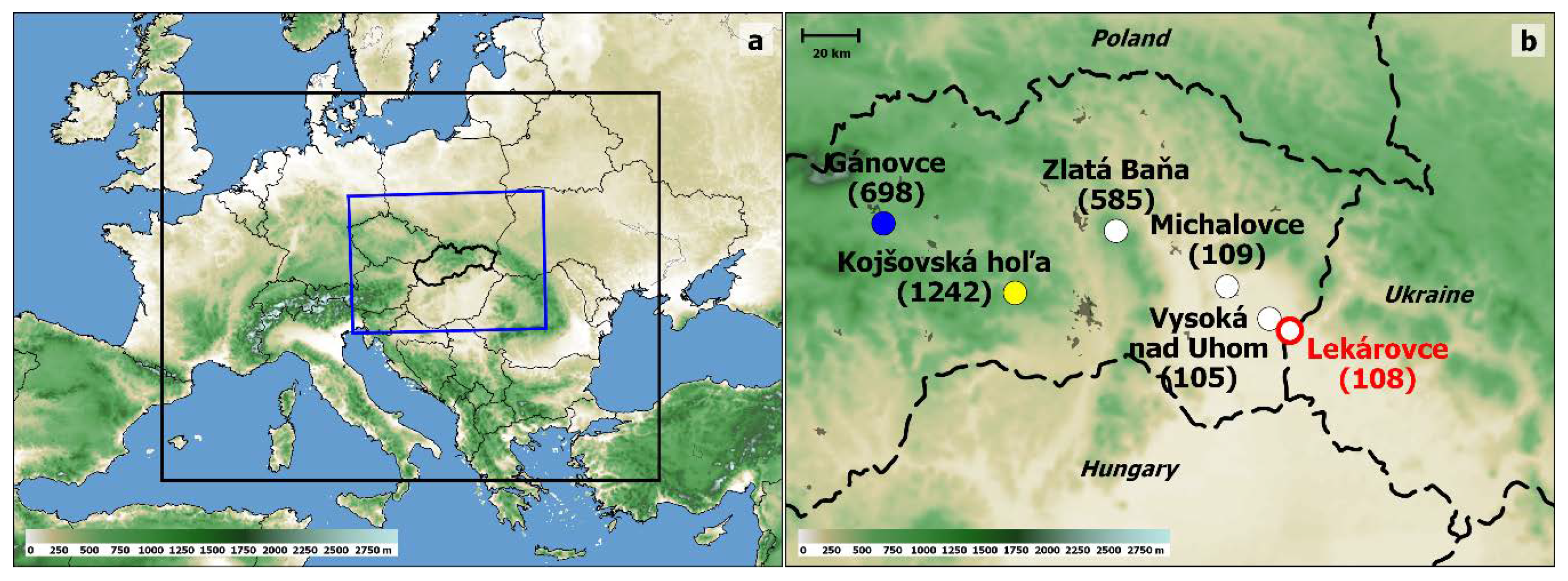
2. Methodology
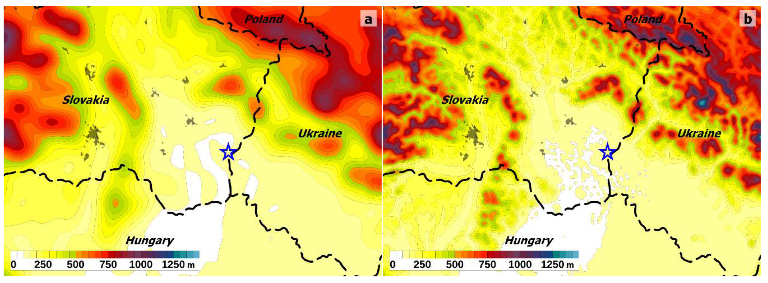
3. Results
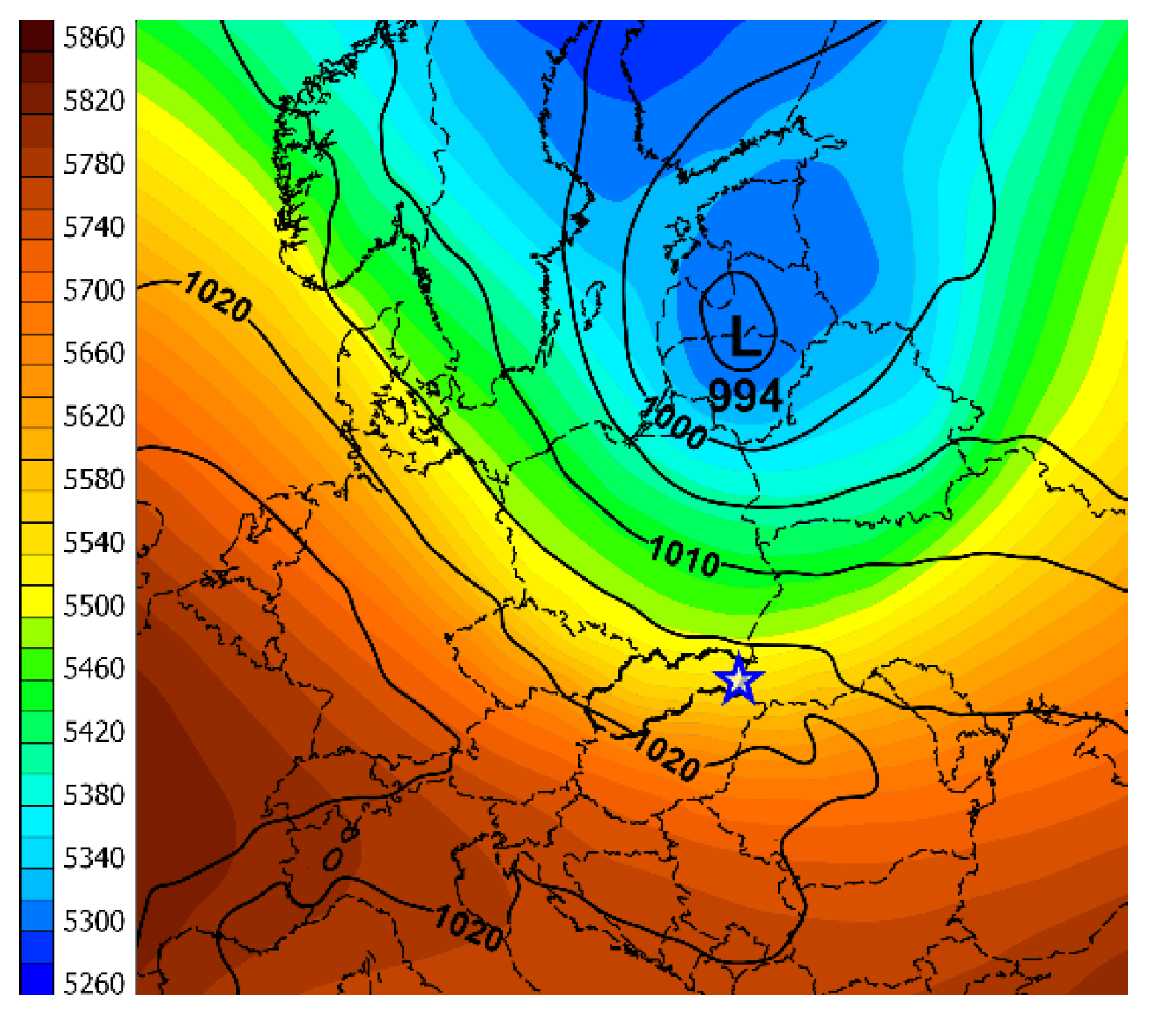
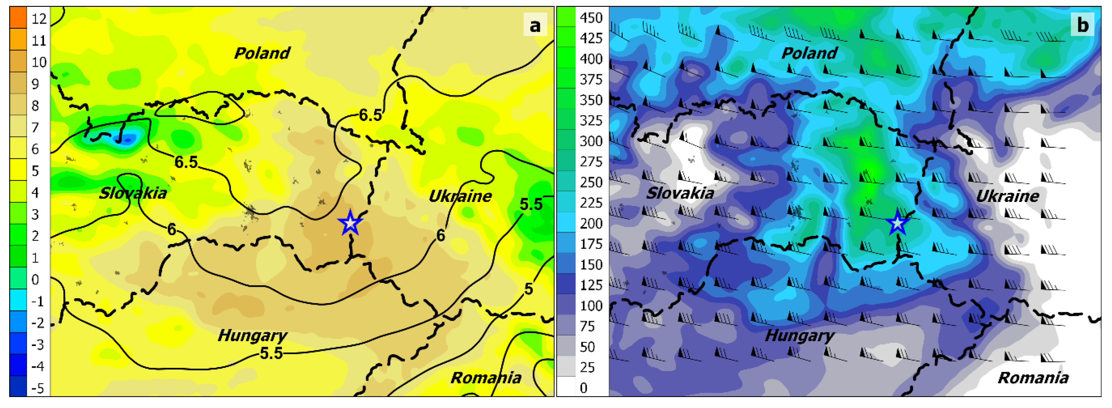
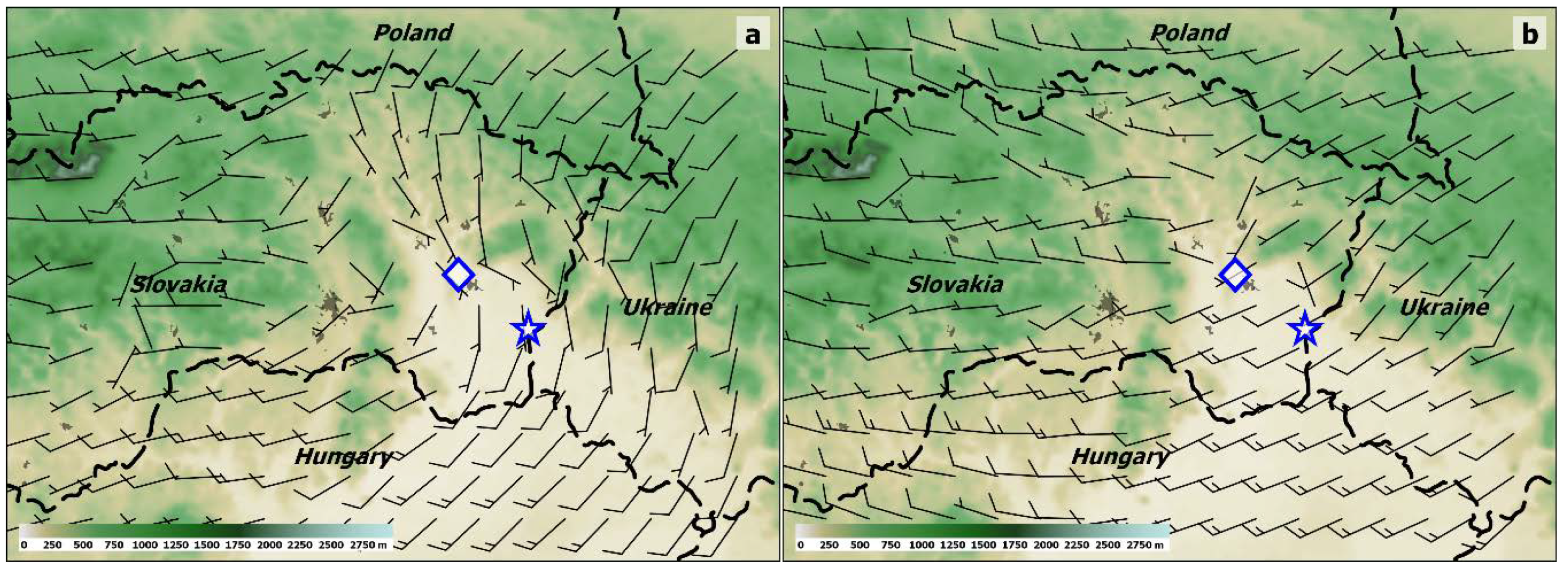
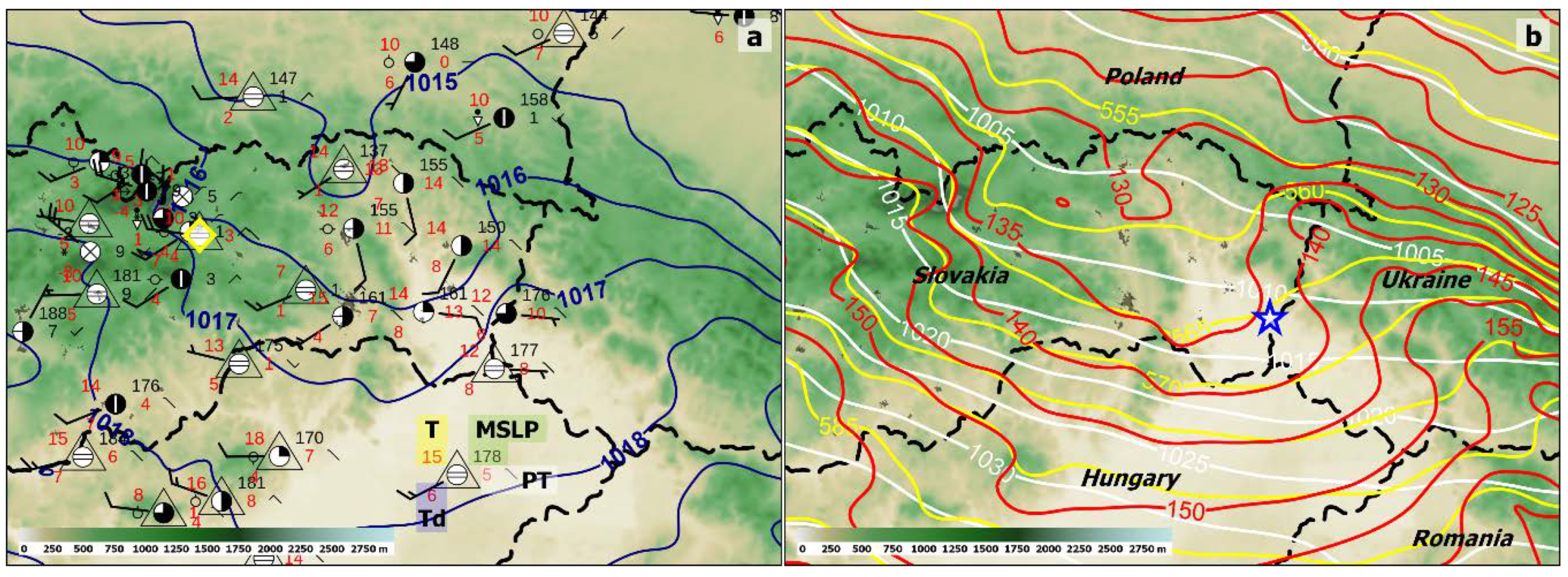
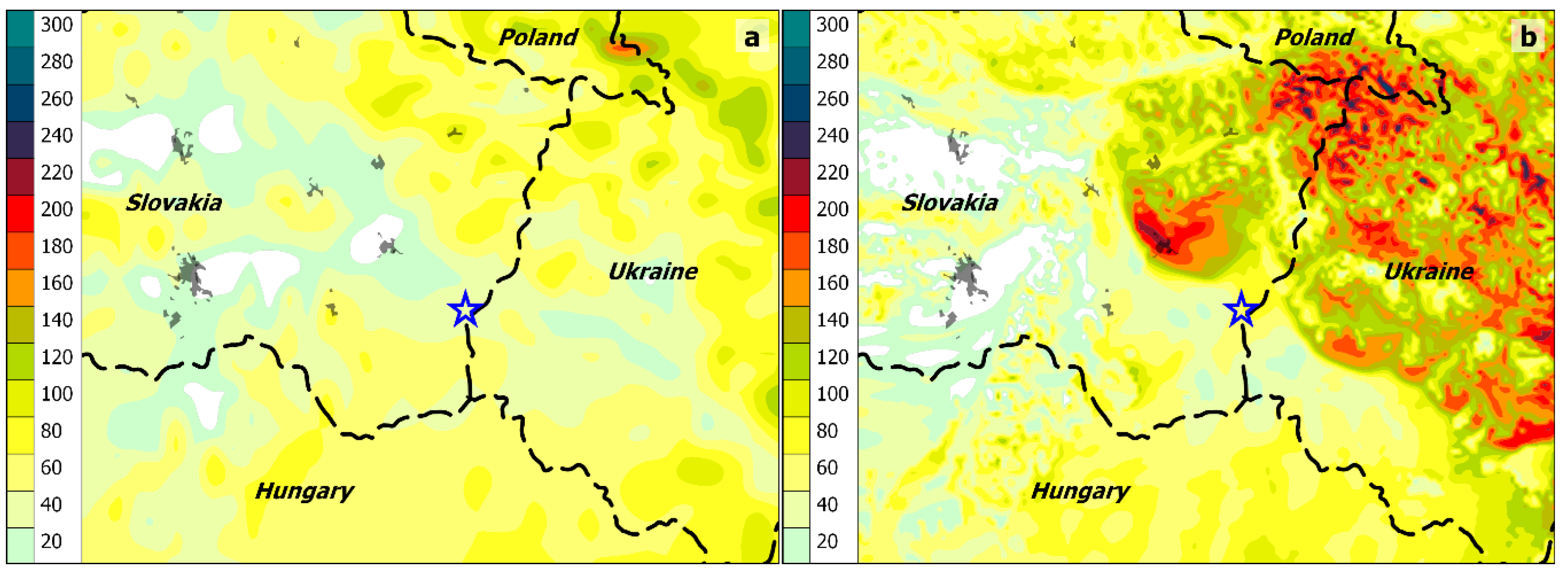
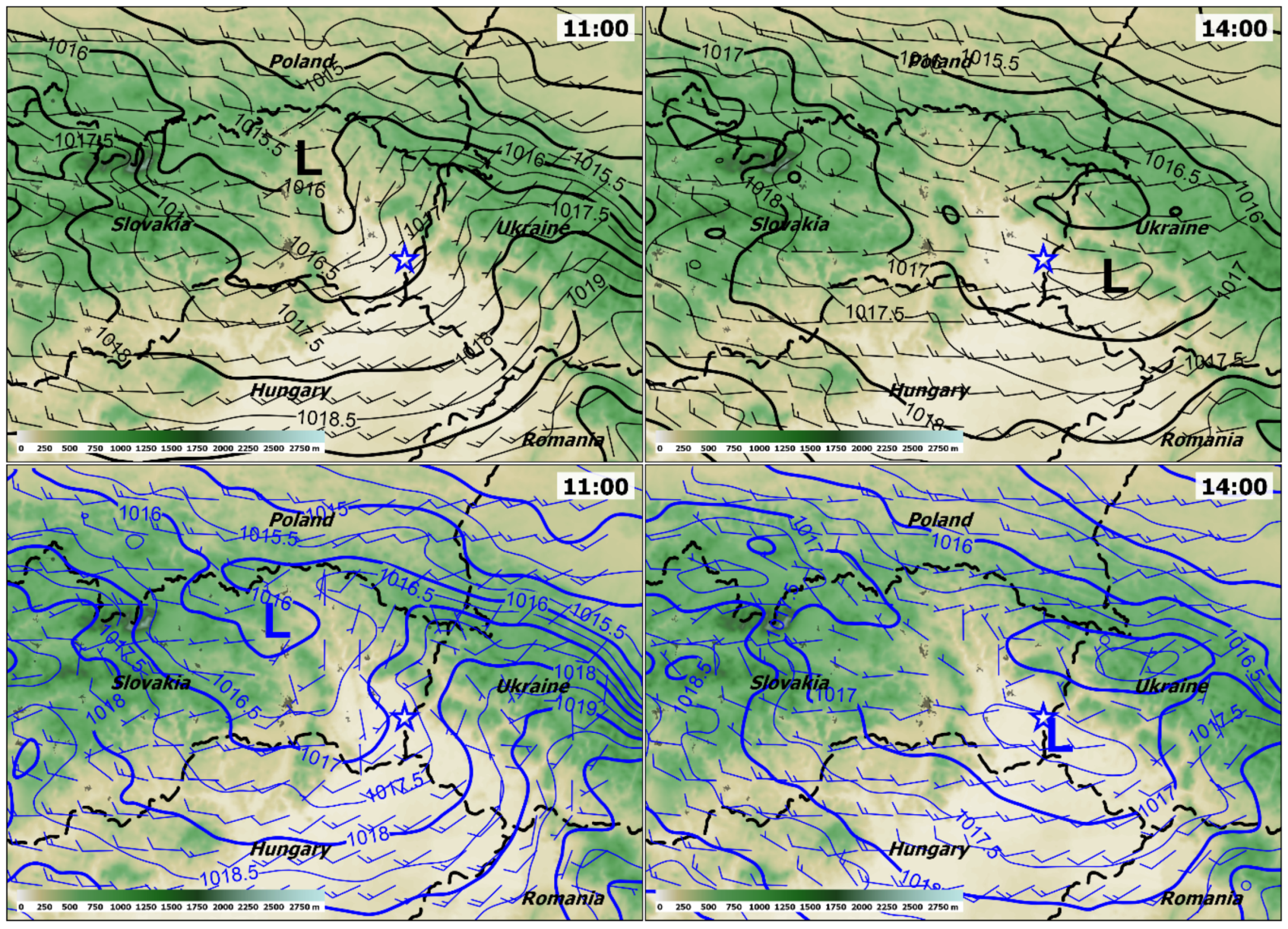
3.1. Prestorm Environment According to Numerical Models Available to Forecasters
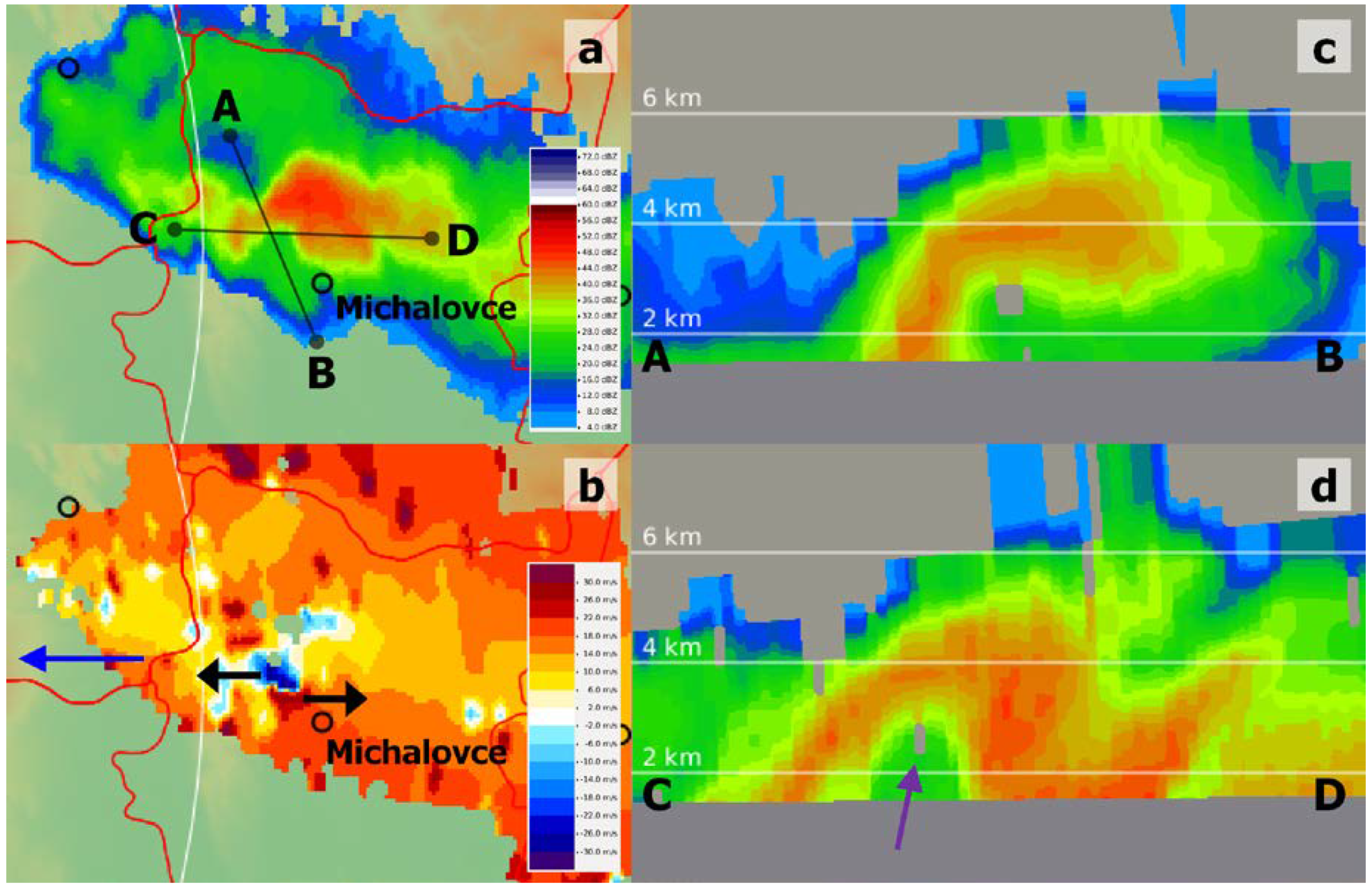
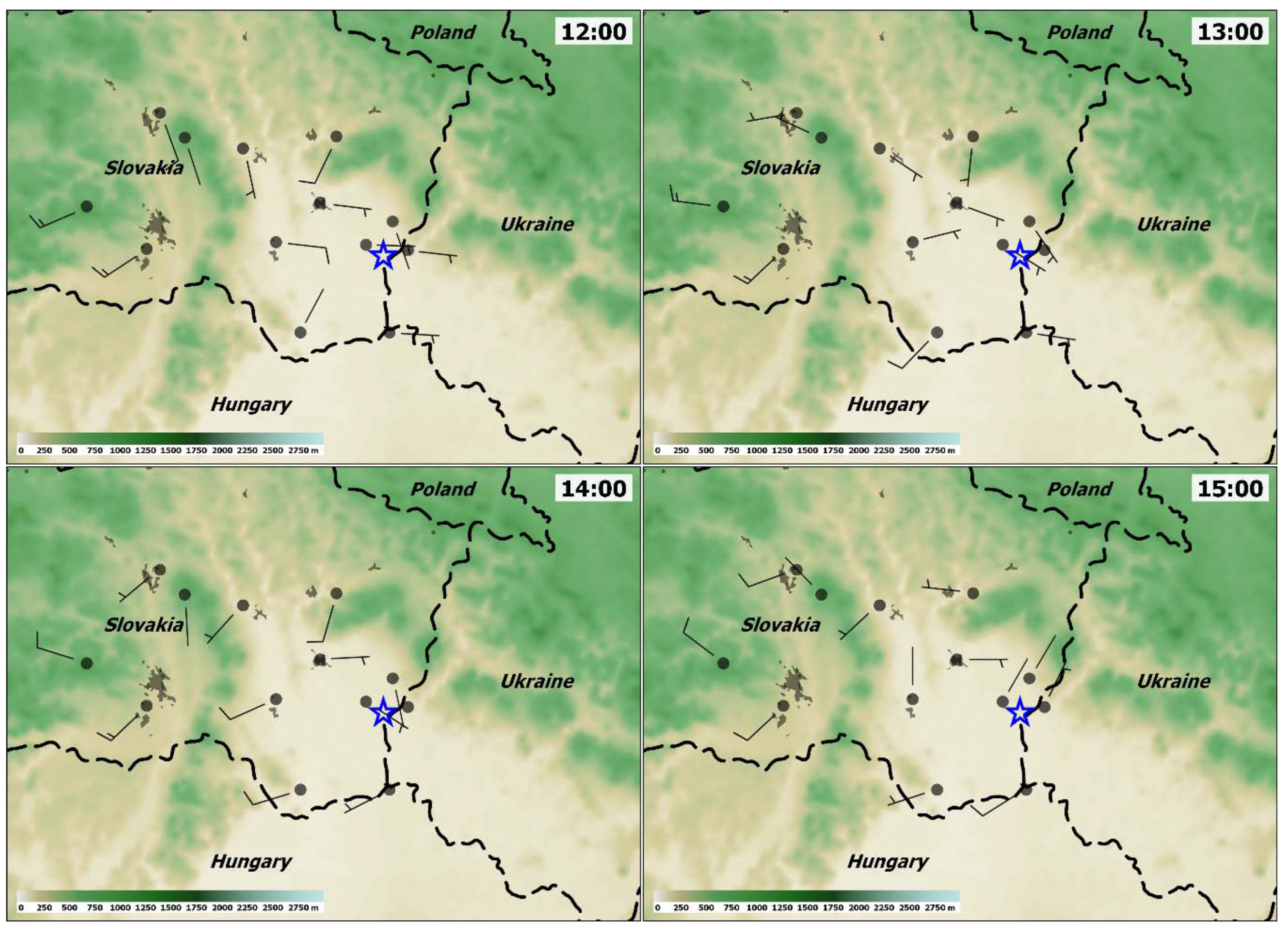
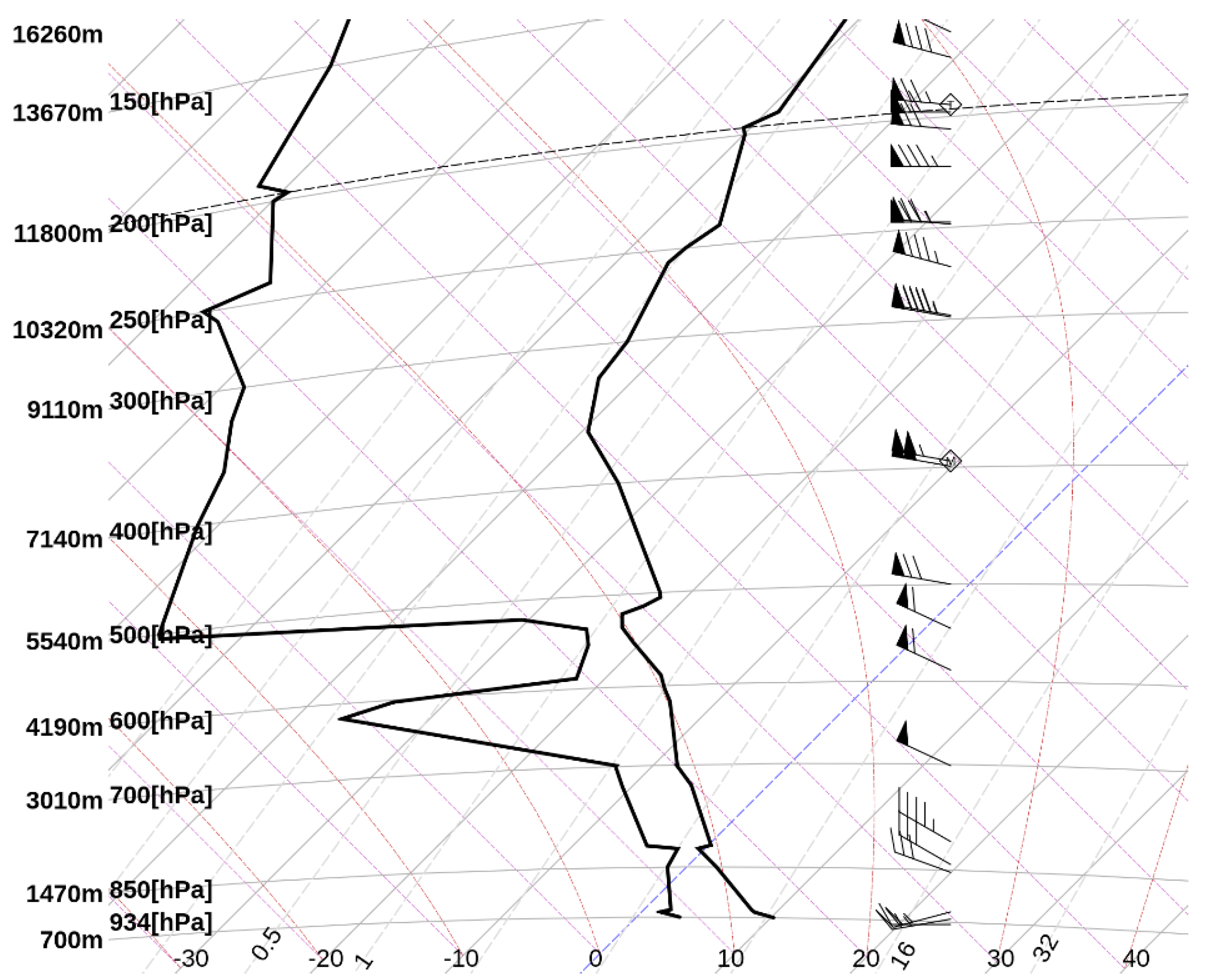
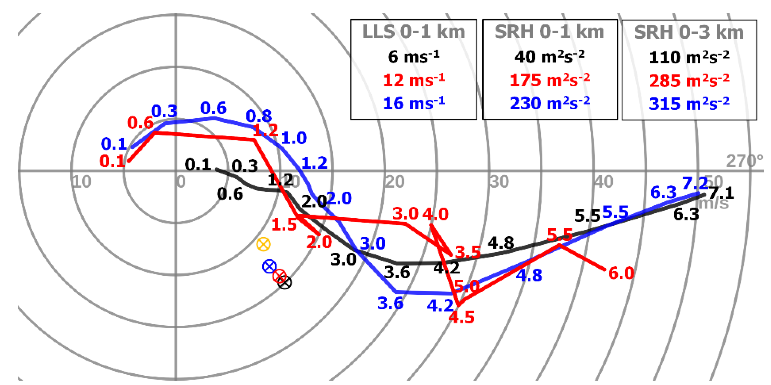
3.2. Observational Data
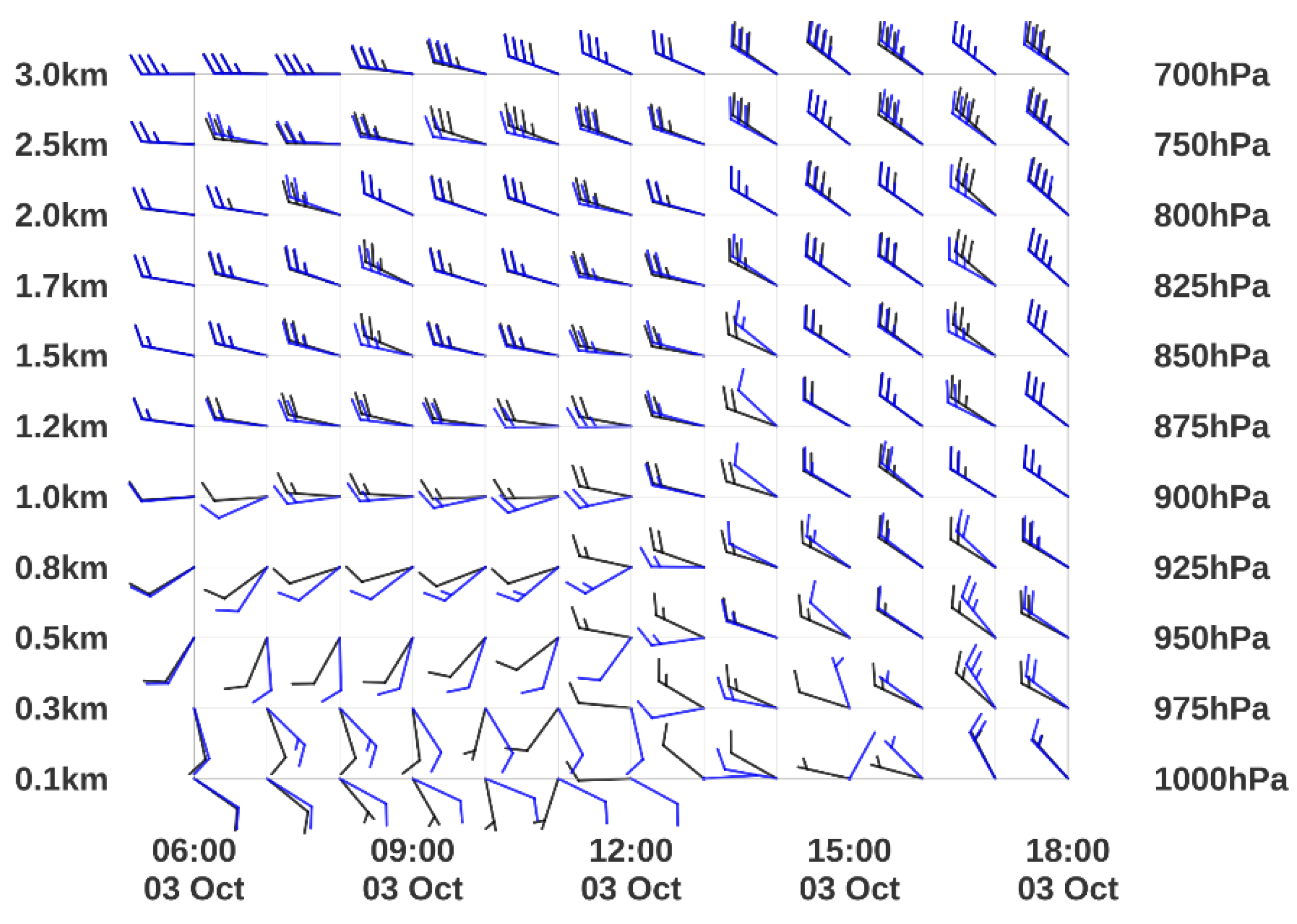
3.3. High-Resolution Experimental Local-Area Model (ELAM)
4. Discussion and Conclusions
Author Contributions
Funding
Acknowledgments
Conflicts of Interest
References
- Brooks, H.E.; Doswell, C.A., III; Zhang, X.; Chernokulsky, A.A.; Tochimoto, E.; Hanstrum, B.; de Lima Nascimento, E.; Sills, D.M.; Antonescu, B.; Barrett, B. A century of progress in severe convective storm research and forecasting. Meteorol. Monographs. 2019, 59, 18.1–18.41. [Google Scholar] [CrossRef]
- Johns, R.H.; Doswell, C.A., III. Severe local storms forecasting. Weather Forecast. 1992, 7, 588–612. [Google Scholar] [CrossRef]
- Doswell, C.A., III; Brooks, H.E.; Maddox, R.A. Flash flood forecasting: An ingredients-based methodology. Weather Forecast. 1996, 11, 560–581. [Google Scholar] [CrossRef]
- Rasmussen, E.N.; Blanchard, D.O. A baseline climatology of sounding-derived supercell and tornado forecast parameters. Weather Forecast. 1998, 13, 1148–1164. [Google Scholar] [CrossRef]
- Thompson, R.L.; Edwards, R.; Hart, J.A.; Elmore, K.L.; Markowski, P. Close proximity soundings within supercell environments obtained from the rapid update cycle. Weather Forecast. 2003, 18, 1243–1261. [Google Scholar] [CrossRef]
- Weisman, M.L.; Klemp, J.B. The dependence of numerically simulated convective storms on vertical wind shear and buoyancy. Mon. Weather Rev. 1982, 110, 504–520. [Google Scholar] [CrossRef]
- Davies-Jones, R. Streamwise vorticity: The origin of updraft rotation in supercell storms. J. Atmos. Sci. 1984, 41, 2991–3006. [Google Scholar] [CrossRef]
- Thompson, R.L.; Mead, C.M.; Edwards, R. Effective storm-relative helicity and bulk shear in supercell thunderstorm environments. Weather Forecast. 2007, 22, 102–115. [Google Scholar] [CrossRef]
- Trapp, R.J.; Stumpf, G.J.; Manross, K.L. A reassessment of the percentage of tornadic mesocyclones. Weather Forecast. 2005, 20, 680–687. [Google Scholar] [CrossRef]
- Markowski, P.M.; Straka, J.M.; Rasmussen, E.N. Direct surface thermodynamic observations within the rear-flank downdrafts of nontornadic and tornadic supercells. Mon. Weather Rev. 2002, 130, 1692–1721. [Google Scholar] [CrossRef]
- Markowski, P.M.; Richardson, Y.P. The influence of environmental low-level shear and cold pools on tornadogenesis: Insights from idealized simulations. J. Atmos. Sci. 2014, 71, 243–275. [Google Scholar] [CrossRef]
- Guarriello, F.; Nowotarski, C.J.; Epifanio, C.C. Effects of the low-level wind profile on outflow position and near-surface vertical vorticity in simulated supercell thunderstorms. J. Atmos. Sci. 2018, 75, 731–753. [Google Scholar] [CrossRef]
- Brown, M.; Nowotarski, C.J. The Influence of Lifting Condensation Level on Low-Level Outflow and Rotation in Simulated Supercell Thunderstorms. J. Atmos. Sci. 2019, 76, 1349–1372. [Google Scholar] [CrossRef]
- Craven, J.P.; Brooks, H.E. Baseline climatology of sounding derived parameters associated with deep, moist convection. Natl. Weather Dig. 2004, 28, 13–24. Available online: https://www.nssl.noaa.gov/users/brooks/public_html/papers/cravenbrooksnwa.pdf (accessed on 20 March 2020).
- Grams, J.S.; Thompson, R.L.; Snively, D.V.; Prentice, J.A.; Hodges, G.M.; Reames, L.J. A climatology and comparison of parameters for significant tornado events in the United States. Weather Forecast. 2012, 27, 106–123. [Google Scholar] [CrossRef]
- Púčik, T.; Groenemeijer, P.; Rýva, D.; Kolář, M. Proximity soundings of severe and nonsevere thunderstorms in central Europe. Mon. Weather Rev. 2015, 143, 4805–4821. [Google Scholar] [CrossRef]
- Taszarek, M.; Brooks, H.E.; Czernecki, B. Sounding-derived parameters associated with convective hazards in Europe. Mon. Weather Rev. 2017, 145, 1511–1528. [Google Scholar] [CrossRef]
- Esterheld, J.M.; Giuliano, D.J. Discriminating between tornadic and non-tornadic supercells: A new hodograph technique. E-J. Sev. Storms Meteorol. 2008, 3, 2. Available online: https://ejssm.org/ojs/index.php/ejssm/article/viewArticle/33 (accessed on 20 March 2020).
- Nowotarski, C.J.; Jensen, A.A. Classifying proximity soundings with self-organizing maps toward improving supercell and tornado forecasting. Weather Forecast. 2013, 28, 783–801. [Google Scholar] [CrossRef]
- Coffer, B.E.; Parker, M.D.; Dahl, J.M.; Wicker, L.J.; Clark, A.J. Volatility of tornadogenesis: An ensemble of simulated nontornadic and tornadic supercells in VORTEX2 environments. Mon. Weather Rev. 2017, 145, 4605–4625. [Google Scholar] [CrossRef]
- Coffer, B.E.; Parker, M.D. Is there a “tipping point” between simulated nontornadic and tornadic supercells in VORTEX2 environments? Mon. Weather Rev. 2018, 146, 2667–2693. [Google Scholar] [CrossRef]
- Coffer, B.E.; Parker, M.D.; Thompson, R.L.; Smith, B.T.; Jewell, R.E. Using near-ground storm relative helicity in supercell tornado forecasting. Weather Forecast. 2019, 34, 1417–1435. [Google Scholar] [CrossRef]
- Kain, J.S.; Weiss, S.J.; Bright, D.R.; Baldwin, M.E.; Levit, J.J.; Carbin, G.W.; Schwartz, C.S.; Weisman, M.L.; Droegemeier, K.K.; Weber, D.B.; et al. Some practical considerations regarding horizontal resolution in the first generation of operational convection-allowing NWP. Weather Forecast. 2008, 23, 931–952. [Google Scholar] [CrossRef]
- Seity, Y.; Lac, C.; Bouyssel, F.; Riette, S.; Bouteloup, Y. Cloud and microphysical schemes in ARPEGE and AROME models. In Proceedings of the ECMWF Workshop on Parametrization of Clouds and Precipitation, Shinfield Park, Reading, UK, 5–8 November 2012; Available online: https://www.ecmwf.int/en/elibrary/12167-cloud-and-microphysical-schemes-arpege-and-arome-models (accessed on 20 May 2020).
- Brousseau, P.; Seity, Y.; Ricard, D.; Léger, J. Improvement of the forecast of convective activity from the AROME-France system. Q. J. R. Meteorol. Soc. 2016, 142, 2231–2243. [Google Scholar] [CrossRef]
- Weisman, M.L.; Evans, C.; Bosart, L. The 8 May 2009 super-derecho: Analysis of a real-time explicit convective forecast. Weather Forecast. 2013, 28, 863–892. [Google Scholar] [CrossRef]
- Sobash, R.A.; Kain, J.S.; Bright, D.R.; Dean, A.R.; Coniglio, M.C.; Weiss, S.J. Probabilistic forecast guidance for severe thunderstorms based on the identification of extreme phenomena in convection-allowing model forecasts. Weather Forecast. 2011, 26, 714–728. [Google Scholar] [CrossRef]
- Clark, A.J.; Kain, J.S.; Marsh, P.T.; Correia, J., Jr.; Xue, M.; Kong, F. Forecasting tornado pathlengths using a three-dimensional object identification algorithm applied to convection-allowing forecasts. Weather Forecast. 2012, 27, 1090–1113. [Google Scholar] [CrossRef]
- Clark, A.J.; Gao, J.; Marsh, P.T.; Smith, T.; Kain, J.S.; Correia, J.; Xue, M.; Kong, F. Tornado pathlength forecasts from 2010 to 2011 using ensemble updraft helicity. Weather Forecast. 2013, 28, 387–407. [Google Scholar] [CrossRef]
- Sobash, R.A.; Schwartz, C.S.; Romine, G.S.; Fossell, K.R.; Weisman, M.L. Severe weather prediction using storm surrogates from an ensemble forecasting system. Weather Forecast. 2016, 31, 255–271. [Google Scholar] [CrossRef]
- Gallo, B.T.; Clark, A.J.; Dembek, S.R. Forecasting tornadoes using convection-permitting ensembles. Weather Forecast. 2016, 31, 273–295. [Google Scholar] [CrossRef]
- Gallo, B.T.; Clark, A.J.; Smith, B.T.; Thompson, R.L.; Jirak, I.; Dembek, S.R. Blended probabilistic tornado forecasts: Combining climatological frequencies with NSSL–WRF ensemble forecasts. Weather Forecast. 2018, 33, 443–460. [Google Scholar] [CrossRef]
- Lawson, J.R. Predictability of idealized thunderstorms in buoyancy—Shear space. J. Atmos. Sci. 2019, 76, 2653–2672. [Google Scholar] [CrossRef]
- Anderson-Frey, A.K.; Richardson, Y.P.; Dean, A.R.; Thompson, R.L.; Smith, B.T. Investigation of near-storm environments for tornado events and warnings. Weather Forecast. 2016, 31, 1771–1790. [Google Scholar] [CrossRef]
- Herman, G.R.; Nielsen, E.R.; Schumacher, R.S. Probabilistic verification of Storm Prediction Center convective outlooks. Weather Forecast. 2018, 33, 161–184. [Google Scholar] [CrossRef]
- Dotzek, N.; Groenemeijer, P.; Feuerstein, B.; Holzer, A.M. Overview of ESSL’s severe convective storms research using the European Severe Weather Database ESWD. Atmos. Res. 2009, 93, 575–586. [Google Scholar] [CrossRef]
- Smith, B.T.; Thompson, R.L.; Grams, J.S.; Broyles, C.; Brooks, H.E. Convective modes for significant severe thunderstorms in the contiguous United States. Part I: Storm classification and climatology. Weather Forecast. 2012, 27, 1114–1135. [Google Scholar] [CrossRef]
- Šinger, M. Occurrence of supercells in Slovakia in 2000–2012. In Proceedings of the 9th European Conference of Severe Storms (ECSS), Pula, Italy, 18–22 September 2017; ECSS2017-166. Available online: https://presentations.copernicus.org/ECSS2017/ECSS2017-166_presentation.pdf (accessed on 20 May 2020).
- Šinger, M. Tornádo in lekárovce. Meteorol. J. 2018, 21, 109–116. Available online: http://www.shmu.sk/File/ExtraFiles/MET_CASOPIS/MC_2018-2.pdf (accessed on 28 April 2020).
- Gerard, L.; Piriou, J.-M.; Brožková, R.; Geleyn, J.-F.; Banciu, D. Cloud and precipitation parameterization in a meso-gammascale operational weather prediction model. Mon. Weather Rev. 2009, 137, 3960–3977. [Google Scholar] [CrossRef]
- Brožková, R.; Bučánek, A.; Mašek, J.; Smoliková, P.; Trojáková, A. Nová provozní konfigurace modelu Aladin ve vysokém rozlišení. Meteorol. Zprávy 2019, 72, 129–139. Available online: http://www.cmes.cz/sites/default/files/chmu_mz_5-19_129-139.pdf (accessed on 6 June 2020).
- Derková, M.; Vivoda, J.; Belluš, M.; Španiel, O.; Dian, M.; Neštiak, M.; Zehnal, R. Recent improvements in the ALADIN/SHMU operational system. Meteorol. J. 2017, 20, 45–52. Available online: http://www.shmu.sk/File/ExtraFiles/MET_CASOPIS/2017-2__MC.pdf (accessed on 28 April 2020).
- Termonia, P.; Fischer, C.; Bazile, E.; Bouyssel, F.; Brožková, R.; Bénard, P.; Bochenek, B.; Degrauwe, D.; Derková, M.; El Khatib, R.; et al. The ALADIN System and its Canonical Model Configurations AROME CY41T1 and ALARO CY40T1. Geosci. Model Dev. 2018, 11, 257–281. [Google Scholar] [CrossRef]
- Lopez, P. Implementation and validation of a new prognostic large-scale cloud and precipitation scheme for climate and data assimilation purposes. Q. J. R. Meteorol. Soc. 2002, 128, 229–257. [Google Scholar] [CrossRef]
- Jurášek, M.; Kaňák, J.; Okon, Ľ.; Méri, L. Calibration & monitoring of Slovak weather radar network. In Proceedings of the Weather Radar Calibration & Monitoring Workshop, 18–20 October 2017; Available online: https://www.dwd.de/EN/specialusers/research_education/met_applications_specials/wxrcalmon2017_presentations/poster_downloads/16_jurasek_wxrcalmon2017_poster.pdf?__blob=publicationFile&v=2 (accessed on 6 June 2020).
- Thompson, R.L.; Smith, B.T.; Grams, J.S.; Dean, A.R.; Broyles, C. Convective modes for significant severe thunderstorms in the contiguous United States. Part II: Supercell and QLCS tornado environments. Weather Forecast. 2012, 27, 1136–1154. [Google Scholar] [CrossRef]
- Bunkers, M.J.; Klimowski, B.A.; Zeitler, J.W.; Thompson, R.L.; Weisman, M.L. Predicting supercell motion using a new hodograph technique. Weather Forecast. 2000, 15, 61–79. [Google Scholar] [CrossRef]
- Anderson-Frey, A.K.; Richardson, Y.P.; Dean, A.R.; Thompson, R.L.; Smith, B.T. Near-storm environments of outbreak and isolated tornadoes. Weather Forecast. 2018, 33, 1397–1412. [Google Scholar] [CrossRef]
- Grünwald, S.; Brooks, H.E. Relationship between sounding derived parameters and the strength of tornadoes in Europe and the USA from reanalysis data. Atmos. Res. 2011, 100, 479–488. [Google Scholar] [CrossRef]
- Réthly, A. Időjárási események és elemi csapások Magyarországon 1801–1900-ig. Bp. Országos Meteorológiai Szolgálat 1998, 1, 226–227. [Google Scholar]
- Živelné Pohromy na Slovensku—Tornádo v obci Slovenská Ves. Available online: https://terabis.webgarden.cz/rubriky/zivelne-pohromy-na-slovensku/tornado-slovenska-ves (accessed on 15 April 2020).
- Simon, A.; Sokol, A. Tornáda a Iné Nebezpečné Búrkové Javy na Území Slovenska, Slovak Hydrometeorological Institute Report. Available online: http://www.shmu.sk/File/studijne%20materialy/tornada.pdf (accessed on 15 April 2020).
- Sokol, A. Possible Tornado Occurence in BUDATINSKA Lehota Village on 19th March 2001. 2002. Available online: https://www.essl.org/ECSS/2002/abstracts/30.htm (accessed on 28 April 2020).
- Bosart, L.F.; Seimon, A.; LaPenta, K.D.; Dickinson, M.J. Supercell tornadogenesis over complex terrain: The Great Barrington, Massachusetts, tornado on 29 May 1995. Weather Forecast. 2006, 21, 897–922. [Google Scholar] [CrossRef]
- Peyraud, L. Analysis of the 18 July 2005 tornadic supercell over the Lake Geneva region. Weather Forecast. 2013, 28, 1524–1551. [Google Scholar] [CrossRef][Green Version]
- Tang, B.; Vaughan, M.; Lazear, R.; Corbosiero, K.; Bosart, L.; Wasula, T.; Lee, I.; Lipton, K. Topographic and boundary influences on the 22 May 2014 Duanesburg, New York, tornadic supercell. Weather Forecast. 2016, 31, 107–127. [Google Scholar] [CrossRef]
- Lyza, A.W.; Knupp, K.R. A background investigation of tornado activity across the southern Cumberland Plateau terrain system of northeastern Alabama. Mon. Weather Rev. 2018, 146, 4261–4278. [Google Scholar] [CrossRef]
- Lyza, A.W.; Murphy, T.A.; Goudeau, B.T.; Pangle, P.T.; Knupp, K.R.; Wade, R.A. Observed Near-storm Environment Variations across the Southern Cumberland Plateau System in Northeastern Alabama. Mon. Weather Rev. 2020, 148, 1465–1482. [Google Scholar] [CrossRef]
- Pilguj, N.; Taszarek, M.; Pajurek, Ł.; Kryza, M. High-resolution simulation of an isolated tornadic supercell in Poland on 20 June 2016. Atmos. Res. 2019, 218, 145–159. [Google Scholar] [CrossRef]


| Description | ALADIN/SHMU (OPM) | ALADIN/ELAM (ELAM) |
|---|---|---|
| Horizontal resolution | 4.5 km | 1 km |
| Number of grid points | 625 × 576 | 1000 × 720 |
| Spectral resolution | 312 × 278 (linear truncation) | 499 × 359 (linear truncation) |
| Number of vertical levels | 63 | 73 |
| Dynamics | Hydrostatic | Nonhydrostatic |
| Physics | ALARO-1vB | ALARO-1vB |
| Microphysics | Lopez [44] | Lopez [44] |
| Deep convection | 3MT [40] | 3MT [40] |
| Time step | 180 s | 60 s |
| Coupling model | ARPEGE | ALADIN/SHMU |
| Coupling frequency | 3 h | 1 h |
| Assimilation | Upper-air spectral blending with CANARI surface assimilation | Dynamical downscaling |
| Run | 3 October 2018, 06:00 Coordinated Universal Time (UTC) | 3 October 2018, 06:00 UTC |
| Forecast range | 72 h | 12 h |
© 2020 by the authors. Licensee MDPI, Basel, Switzerland. This article is an open access article distributed under the terms and conditions of the Creative Commons Attribution (CC BY) license (http://creativecommons.org/licenses/by/4.0/).
Share and Cite
Šinger, M.; Púčik, T. A Challenging Tornado Forecast in Slovakia. Atmosphere 2020, 11, 821. https://doi.org/10.3390/atmos11080821
Šinger M, Púčik T. A Challenging Tornado Forecast in Slovakia. Atmosphere. 2020; 11(8):821. https://doi.org/10.3390/atmos11080821
Chicago/Turabian StyleŠinger, Miroslav, and Tomáš Púčik. 2020. "A Challenging Tornado Forecast in Slovakia" Atmosphere 11, no. 8: 821. https://doi.org/10.3390/atmos11080821
APA StyleŠinger, M., & Púčik, T. (2020). A Challenging Tornado Forecast in Slovakia. Atmosphere, 11(8), 821. https://doi.org/10.3390/atmos11080821