Article

Spatiotemporal Distribution of Major Aerosol Types over China Based on MODIS Products between 2008 and 2017

1
School of Energy Science and Engineering, Harbin Institute of Technology, 92 Xidazhi Street, Harbin 150001, China
2
Key Laboratory of Aerospace Thermophysics, Ministry of Industry and Information Technology, Harbin Institute of Technology, Harbin 150001, China
3
School of Urban Construction, Wuhan University of Science and Technology, Wuhan 430081, China
*
Author to whom correspondence should be addressed.
Atmosphere 2020, 11(7), 703; https://doi.org/10.3390/atmos11070703
Submission received: 8 May 2020 / Revised: 11 June 2020 / Accepted: 21 June 2020 / Published: 1 July 2020
(This article belongs to the Section Aerosols)

Abstract

:
Knowledge of aerosol-type distribution is critical to the evaluation of aerosol–climate effects. However, research on aerosol-type distribution covering all is limited. This study characterized the spatiotemporal distribution of major aerosol types over China by using MODerate resolution Imaging Spectroradiometer (MODIS) products from 2008 to 2017. Two aerosol-type classification methods were combined to achieve this goal. One was for relatively high aerosol load (AOD ≥ 0.2) using aerosol optical depth (AOD) and aerosol relative optical depth (AROD) and the other was for low aerosol load (AOD < 0.2) using land use and population density information, which assumed that aerosols are closely related to local emissions. Results showed that the dominant aerosol-type distribution has a distinct spatial and temporal pattern. In western China, background aerosols (mainly dust/desert dust and continent aerosol) dominate with a combined occurrence ratio over 70% and they have slight variations on seasonal scale. While in eastern China, the dominant aerosols show strong seasonal variations. Spatially, mixed aerosols dominate most parts of eastern China in spring due to the influence of long-range transported dust from Taklamakan and Gobi desert and urban/industry aerosols take place in summer due to strong photochemical reactions. Temporally, mixed and urban/industry aerosols co-dominate eastern China.

1. Introduction

Aerosols are key components in the atmosphere [1,2]. They directly influence Earth’s energy budget by absorbing and scattering shortwave solar and longwave Earth radiations and also indirectly influence the energy budget by acting as cloud condensation nuclei [3]. Different types of aerosols usually originate from different sources and their particle sizes and chemical components may vary significantly [4,5]. Such variations will lead to distinct absorbing and scattering properties and, thus, produce different levels of direct radiative forcing and aerosol–cloud interactions [3,6,7,8]. Aerosol type is also a key parameter in passive satellite inversion algorithms [9]. Since most satellite sensors have limited channels to provide useful information and the related radiative transfer simulation is quite complicated, the algorithm developers chose to preset the aerosol type in order to reduce the unknowns and simplify the radiative transfer process and eventually achieve a successful retrieval [10]. A proper assumption of aerosol type is the basis to obtain reasonable aerosol optical properties, while improper assumption may lead to large uncertainties [11,12]. Therefore, detailed knowledge of spatiotemporal distribution characteristics of aerosol types is necessary for a better understanding of aerosol–climate effects as well as more accurate satellite remote sensing products [13,14].
Previous studies have shown that aerosol type can be identified through optical properties, such as aerosol optical depth (AOD), Angstrom exponent (AE), single scattering albedo (SSA), fine mode fraction (FMF), and aerosol relative optical depth (AROD) [15,16,17]. Since China has diverse terrain and a large population, it has various aerosol types and becomes an ideal place for aerosol studies [18]. There are numerous studies providing information of annual or seasonal characteristics of aerosol types using ground-based measurements over China. For example, Zhu et al. [19] characterized the aerosol-type properties using AE and Absorption Angstrom Exponent (AAE) at Xinglong, a regional background atmosphere in the north China plain, from 2006 to 2011; Zhu et al. [20] analyzed dominant aerosol types through AOD and AE at Kunming, an urban site in southwest China; Chen et al. [21] analyzed the seasonal aerosol-type variations at Harbin, a metropolis at the highest latitude in northeast China, from 2016 to 2017; Che et al. [22] classified the aerosol types using SSA and AE at seven sites in the Yangtze River Delta from 2011 to 2015; Zhang and Li [11] identified the dominant aerosol types using two independent methods using data from 47 Aerosol Robotic Network (AERONET) sites in China. Although ground-based observation of aerosol-type variability enhanced our understanding of aerosol-type variabilities, it was confined to limited coverage [23,24]. Satellite remote sensing offers aerosol monitoring at a larger scale and, with the continuous advancement of remote sensing algorithms and emergence of new space-borne sensors, studies on aerosol properties using satellite data have increased in recent years. For example, Zhao, Jiang, Diner, Su, Gu, Liou, Jiang, Huang, Takano, Fan, and Omar [24] investigated seasonal variations of aerosol loading, vertical distribution, and particle types over east China regions using combined satellite observations and Kumar et al. [25] classified major aerosol types over Nanjing, an urban-industrial city in east China, using simultaneous datasets retrieved from the Moderate-resolution Imaging Spectroradiometer (MODIS) and Ozone Monitoring Instrument (OMI) sensors. However these studies only covered part of China. A comprehensive study on the spatiotemporal distributions of major aerosol types across the whole country is still very scarce.
Specifying background aerosol types over different terrains is important for separating anthropogenic effects from natural variability and evaluating climate effects of specific aerosol types, e.g., urban/industrial, biomass burning, dust, etc. [26]. Background aerosol type is a key factor for some satellite retrieval algorithms performing atmospheric corrections of surface reflectance to remove the background aerosol contributions from satellite signals [27,28]. However, in most of the current research, which focuses on establishing aerosol-classification methods, aerosol with AOD less than a specific threshold value (e.g., 0.5) was simply classified as a background or continent type [29,30] or, although AOD is not directly used in classification methods (e.g., SSA–FMF, Scattering Angstrom Exponent–AE), the indicators used to identify aerosol types, like SSA, scattering Angstrom exponent (SAE), and refractive index (RI), from the AERONET inversion products are only available when AOD at 440 nm is greater than 0.4 [31,32]. Since ground-based aerosol monitoring sites were generally established at specific locations around the world, the background aerosol is certain and needs not to be refined when applying the classification method to a single point. But when ground-based aerosol-classification methods are applied to satellite remote sensing, a simple type of background aerosol cannot describe the complex aerosol condition over a wide terrestrial surface, especially for countries like China, which has vast and diverse territory. Therefore, a background aerosol-subtype classification method is needed to identify different background aerosols over large terrains. Background aerosol represents a basic aerosol condition on a regional scale and is closely related to local emission source [33]. Previous studies have shown that fire emissions (including aerosols and gases) are closely related to surface land properties and, for any given geographical location, the emission characteristics should be roughly constant [34,35,36]. Thus, the background aerosol type can be linked to the land use information.
This study used MODIS AOD products to characterize the spatiotemporal distributions of major aerosol types across the whole country, and background aerosol subtypes were discriminated by using the land use information and population density. Annual and seasonal patterns of aerosol-type variation were discussed for the whole country and also typical regions (e.g., North China Plain, Yangtze Delta Region, and Sichuan Basin, and aerosol properties, like AOD, SSA, refractive index, and size information of typical aerosol types, were summarized according to previous ground-based studies. The reliability of the presented aerosol-type classification method and potential shortages of this study are also discussed. This paper is organized as follows: Section 2 describes the data and methods, Section 3 presents the spatiotemporal characteristics of aerosol-type distributions over China and also key aerosol properties for typical aerosol types. Section 4 gives a brief conclusion and discusses the the shortages of the presented study.

2. Data and Method

2.1. Study Domain

China is located in eastern Asia with a land area of 9.6 million km2. The dashed line in Figure 1a, called the Hu Line or Heihe-Tengchong line, divides China into two parts. The western half is mainly covered by plateaus and deserts, such as the Tibetan Plateau, Loess Plateau, Taklimakan Desert, and Gobi Desert, and the eastern half is mostly plains and hills with cities and farmlands. Moreover, the eastern half accounts for 42.9% of the country’s total area and 94.4% of country’s total population, whereas the western half accounts for 57.1% of the country’s total area but only 5.6% of the population. Such diverse terrain and large difference in population indicate complex aerosol conditions in the study area [37,38].
To illustrate the regional aerosol-type details, 16 typical regions across China were selected and Figure 1b and Table 1 show their geographical locations. Regions A–D are located at the North China Plain and the Middle and Lower Yangtze Plains and are characterized by year-round anthropogenic emissions and suffer probably the most severe air pollution in China [39,40]. Regions E–H are coastal areas and the aerosol loading there is generally low. However, transported smoke from the southwest countries like Thailand, Laos, and Myanmar sometimes influence local atmosphere. Region I is a relatively clean region compared to regions E–H and sometimes it will be influenced by the transported smoke from the southwest neighbors as well as polluted aerosols from northeast China. Region J is a basin and an agricultural base. Spring transported dust and winter haze due to heating influence local aerosol conditions much [41]. Regions K, M, and N are located in the downwind area and are often influenced by transported dust from the upper wind deserts (e.g., Gobi Desert and Taklamakan Desert). Region L is located in the northeast China plain with a much lower population density than regions A–D. It is a traditional industrial base as well as an agricultural base. Region O is located near the desert and anthropogenic emission there is very low. Region P is the Tibetan Plateau and it is characterized by background or remote continental aerosols [42].

2.2. Data Involved in Aerosol-Type Classification

In this study, data from MODIS, AERONET, and Gridded Population of the World Version 4 collection (GPWv4) were used to classify aerosol types. To be specific, spectral MODIS AOD data were used to identify aerosol types in pixels with AOD ≥ 0.2, while MODIS land cover and population density data from GPWv4 were used to classify the background aerosol subtypes in pixels with AOD <0.2. In addition, AERONET AOD products were used to validate the MODIS AOD dataset.

2.2.1. MODIS Data

MODIS is a passive imaging radiometer on the Terra and Aqua platforms, which have overpass times of 10:30 and 13:30 local time, respectively. It measures the reflected solar and emitted thermal radiations within 36 spectral bands between 0.4 and 14.4 µm and provides near-daily global coverage with varying spatial resolutions (250 m, 500 m, and 1000 m) [10]. MODIS AOD products were retrieved from two separate algorithms, dark target (DT) algorithm and deep blue (DB) algorithm [43]. Here, MODIS-Terra C6.1 AOD 10-km products from both BT and DB algorithms at 0.47, 0.55, and 0.66 µm were used, namely, MOD04_L2 Corrected_Optical_Depth_Land, Deep_Blue_Aerosol_Optical_Depth_550_Land, and Deep_Blue_Spectral_Aerosol_Optical_Depth_Land. Only AOD with quality flags (QA) = 3 was used in this study and no additional cloud screening was applied here. The 10-km AOD was re-gridded to a spatial resolution of 0.1° × 0.1° via a nearest neighbor method before it was used.
MODIS Land Cover Type Product (MCD12Q1) was also applied to classify background aerosol types. The MCD12Q1 product is derived from observations spanning a year’s input of Terra and Aqua data, and it describes global land cover properties at 500-m spatial resolution. The primary land cover classification scheme in MCD12Q1 identifies 17 land cover classes defined by the International Geosphere-Biosphere Programme (IGBP), which contains 11 natural vegetation classes, three developed and mosaicked land classes, and three non-vegetated land classes. In this study, MODIS/Terra + Aqua Land Cover Type Yearly L3 Global 500-m SIN Grid was utilized (Figure S1a). The 500-m land cover-type product was re-gridded to the same spatial resolution of 0.1° × 0.1° via a nearest neighbor method before overlapping.

2.2.2. Population Density

The Gridded Population of the World Version 4 (GPWv4) collection is released by the Socioeconomic Data and Applications Center (SEDAC) under NASA’s Earth Observing System Data and Information System. GPW provides estimates of global population density distribution for the years 2000, 2005, 2010, 2015, and 2020 based on counts consistent with national censuses and population registers [44]. In this study, the average of population density from the v4.11 dataset of the GPWv4 collection for 2010 and 2015 was used to represent the population distribution of China (Figure 1b). Similarly, the population density data was re-gridded to a spatial resolution of 0.1° × 0.1° via a nearest neighbor method before use.

2.2.3. AERONET AOD Products

AERONET is a global aerosol monitoring network, which provides long-term aerosol optical, microphysical, and radiative properties for aerosol research and validation of satellite retrievals [32]. As a standard instrument used in AERONET, the CIMEL CE-318 sun photometer measures the direct sun and diffuse sky radiance at eight spectral channels between 0.34 and 1.64 µm with a viewing angle of around 1.2° [45]. In this study, the cloud-screened, quality-assured, and well-calibrated Level 2.0 AOD V3 datasets from eight AERONET sites were used (Figure 1a). A brief description of site information can be found in Table S1.

2.3. Aerosol-Type Classification Methods

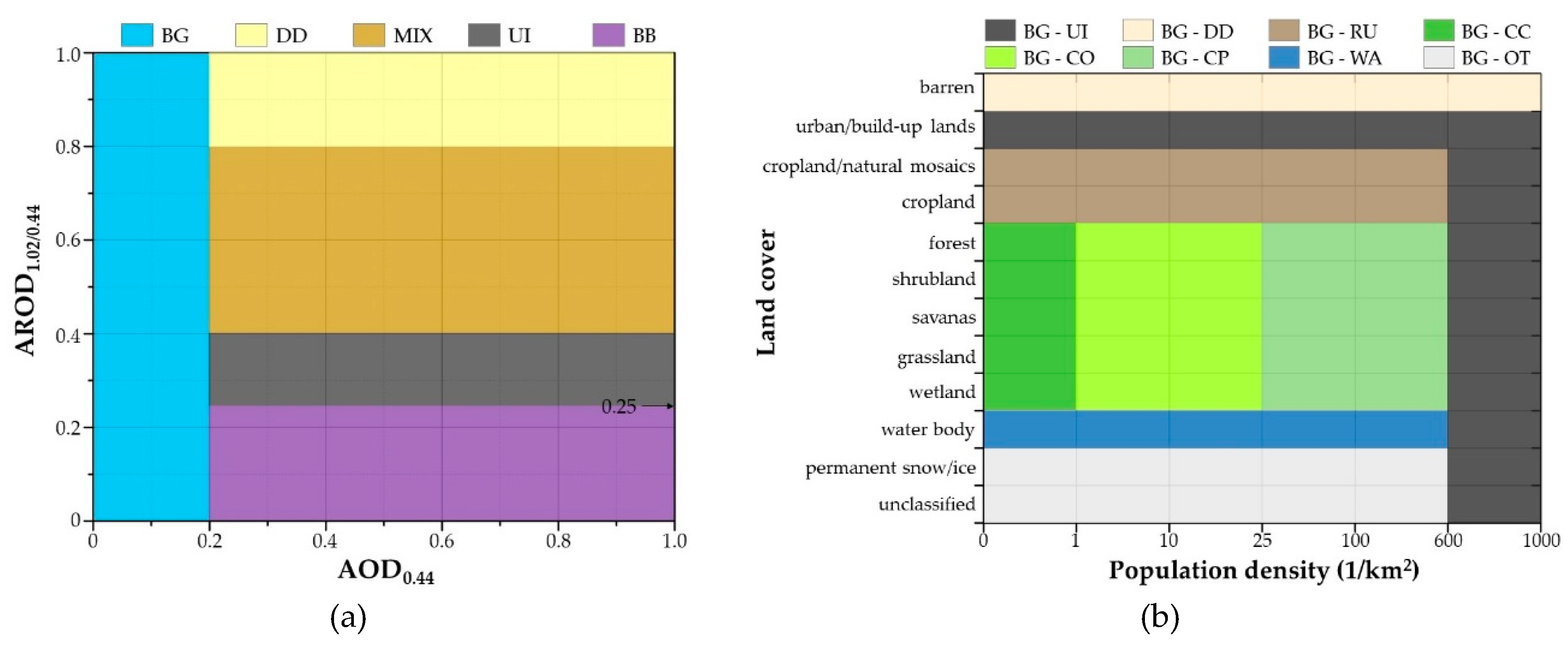
Two independent aerosol-classification methods were combined to analyze the aerosol-type distribution characteristics across China. The first method was an AOD–AROD classification method. This method utilizes AOD at 440 nm and AROD to achieve the identification. AROD is defined as the ratio of AODs at two different wavelengths. To be specific, AROD equals to AOD1020/AOD440. Generally, different aerosols show different spectral AOD characteristics. For example, dust AOD at 440 nm is generally close to the AOD at 1020 nm (1:1), while urban industrial AOD at 440 nm is usually one-third of AOD at 1020 nm (1:3) [15]. Since spectral differences of AODs are quite large for different aerosols, AROD can be used in aerosol-type identification. Based on our previous studies, the AOD–AROD scheme was able to achieve a reliable classification of aerosol type for both ground and satellite observations [15,38]. The AOD–AROD classification scheme identified marine (MA), dust/desert dust (DD), clean continental (CC), subcontinental (SC), urban/industry (UI), and biomass burning (BB) aerosols [15]. MA is a joint name of marine aerosols, which include lots of sea salt particle as well as dimethyl sulfide (DMS). DD refers to the dust particles from desert regions. CC is mostly related to the aerosol in remote continent, which is of low AOD and less influenced by anthropogenic activities. UI is a joint name of urban or industry emissions including black carbon, sulfate particles, and combustion-related and household-related particles. BB represents the aerosol emitted from wild fires and straw burning. It should be noted that three slight modifications were made to our previous AOD–AROD classification method to fit the satellite remote sensing application. Firstly, we renamed the original SC aerosol type to mixed aerosol (MIX) to make this cluster easier and more intuitive to recognize. Secondly, since the current studying domain was over terrestrial China, MA aerosols were removed from this classification method because aerosol loading of marine aerosols is very low (typical AOD ~ 0.05) compared to that over land (typically > 0.3) [31]. Also, MA appear in coastal regions and these regions are mostly with various anthropogenic influence. So a pure MA type is not proper for aerosol-type identification over land and BG, UI, or MIX should be a better choice. Thirdly, we changed the AOD440 threshold value of CC type from 0.5 to 0.2 and renamed it to background aerosol (BG). Taking AOD of 0.5 as a threshold value in our previous AOD–AROD classification method was to assure the identification of UI and BB aerosols. In this study, however, AOD of 0.5 seemed too high for clean regions like western China. It was found that a peak around 0.15–0.2 generally existed in the AOD440 frequency distributions whether in remote or populated urban areas [46], and such a stable peak indicated that AOD440 = 0.2 could serve as the threshold value of BG aerosol type [47]. Figure 2a shows the updated AOD–AROD aerosol-classification method. When AOD was less than 0.2, it was classified as BG aerosol. When AOD was larger than 0.2, AROD < 0.25 represented BB aerosol, AROD between 0.25 and 0.40 represented UI aerosol, AROD between 0.4 and 0.8 represented MIX aerosol, and AROD > 0.8 represented DD aerosol. Two case studies were introduced to show the method performance on a daily scale, and the results can be found in the Supplementary Materials.
The second method is called a background aerosol-subtype estimation method, which aimed to refine the BG aerosol in pixels with AOD < 0.2. To be specific, we divided the BG aerosol type into eight subtypes including continental clean (BG-CC), continental (BG-CO), continental polluted (BG-CP), rural (BG-RU), urban/industry (BG-UI), dust/desert dust (BG-DD), water (BG-WA), and other (BG-OT) aerosols according to land cover and population density information in each pixel. Since the emission characteristics should be roughly constant for any given geographical location [34,35,36], land cover information is suitable to estimate background aerosol subtypes. The only use of land use information, however, is not enough for classifying background aerosols in China. For example, China has vast arable land but its population density is uneven from south to north. The population density over arable land in south China is significantly higher than that in north China (Figure S1b). Although the land cover is the same, regional aerosol components are quite different because of the uneven anthropogenic emissions. To better catch the influence of anthropogenic emissions on classifying background aerosol subtypes, the population density information was introduced. Specifically, we set background aerosol type at pixels with population density larger than 600 per km2 as urban/industrial no matter what kind of land use it was. For pixels with a land use of croplands and crop/natural vegetation mosaics, we defined them as rural when the population density was lower than 600 (the determination of population density threshold value is described in Supplementary Materials). For pixels with a land use of forests, shrublands, savannas, grasslands, and wetlands, we divided them into three subtypes: Continental clean (with population density less than 1), continental (with population density between 1 and 25), and continental polluted aerosols (population density larger than 600). Such a division helped to explain different levels of influence of human emissions on regional aerosol conditions. For pixels with the land use as urban and built-up lands, we defined the background aerosol here as typical urban/industry aerosol, while for barren, water body, and permanent snow/ice/unclassified, we defined the background aerosol types as dust/desert dust, water, and others, respectively. Figure 2b shows the background aerosol-subtype classification method.

2.4. Validation of Satellite Spectral AODs

The spectral AODs used to classify aerosol types in this study were at the wavelength of 0.44 and 1.02 µm. Since MODIS AOD product only provides spectral AODs at 0.47, 0.55, and 0.66 µm, a quadratic polynomial extrapolation method was applied to estimate the AOD0.44 and AOD1.02 (Equation (1)) after a resampling process to a spatial resolution of 0.1° × 0.1° via a nearest neighbor method. To achieve a larger spatiotemporal coverage of AOD observations, the extrapolated DT and DB AOD0.44 and AOD1.02 were then merged following a fusion method proposed by Bilal et al. [48] (Equation (2)).
ln ( τ λ ) = aln ( τ ) + bln 2 ( τ ) + c
τ λ = { τ λ , D T only   τ λ , DT   exists τ λ , D B only   τ λ , DB   exists ( τ λ , D T + τ λ , D B ) / 2 both   τ λ , DT   and   τ λ , DB   exist
where τ λ represents AOD and λ is the wavelength; a, b, and c are coefficients obtained from the spectral AODs at 0.47, 0.55, and 0.66 µm; and subscripts DB and DT represent the AOD sources.
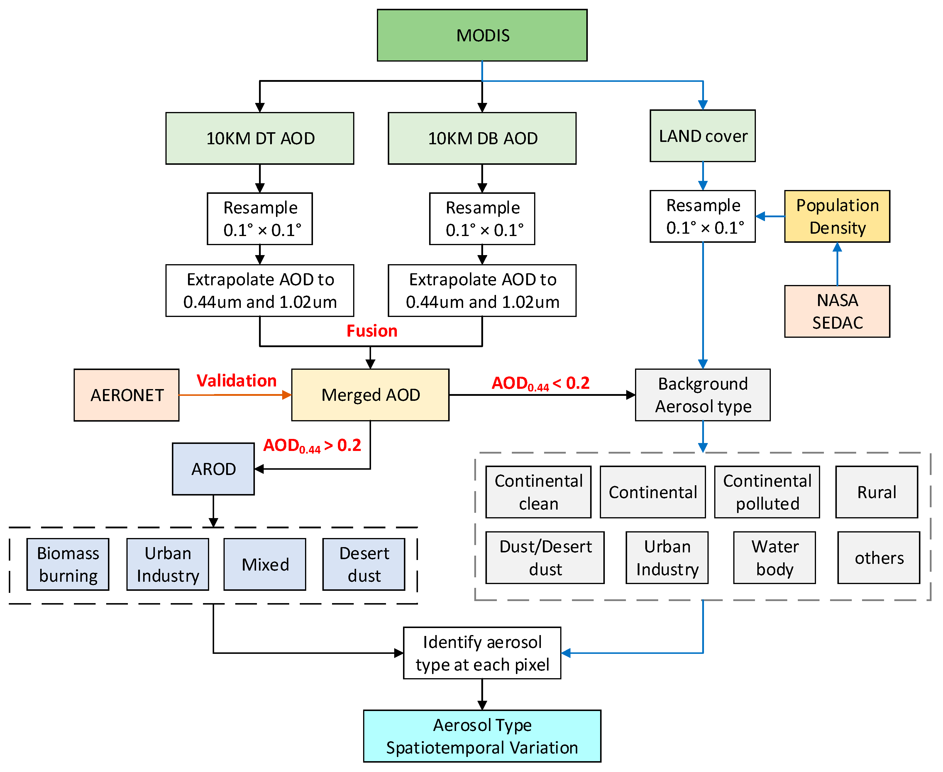
Figure 3 shows the validation results of the merged AOD0.44 and AOD1.02 compared with AERONET observations. The average of AOD within a 0.2° × 0.2° area centered at each site was compared with the average AOD from AERONET within ±30 min of the Terra overpass times. It is evident that the MODIS AOD0.44 and AOD1.02 showed high correlation (R ~ 0.933 and 0.823) with ground-based AERONET observations. Root mean square error (RMSE) values for AOD0.44 and AOD1.02 were 0.313 and 0.162 and relative mean bias (RMB) values were 1.275 and 1.366, respectively. Generally speaking, the good agreement (R > 0.8) between merged and AERONET AODs and the satisfactory MODIS AOD data quality with a percentage of within estimated error envelope (%EE) over 67% indicate that it is feasible to use the merged AOD0.44 and AOD1.02 to classify aerosol types [10]. The general flowchart of this study is shown in Figure 4.

3. Results

3.1. Spatial Distribution of Background Aerosol Subtypes across China

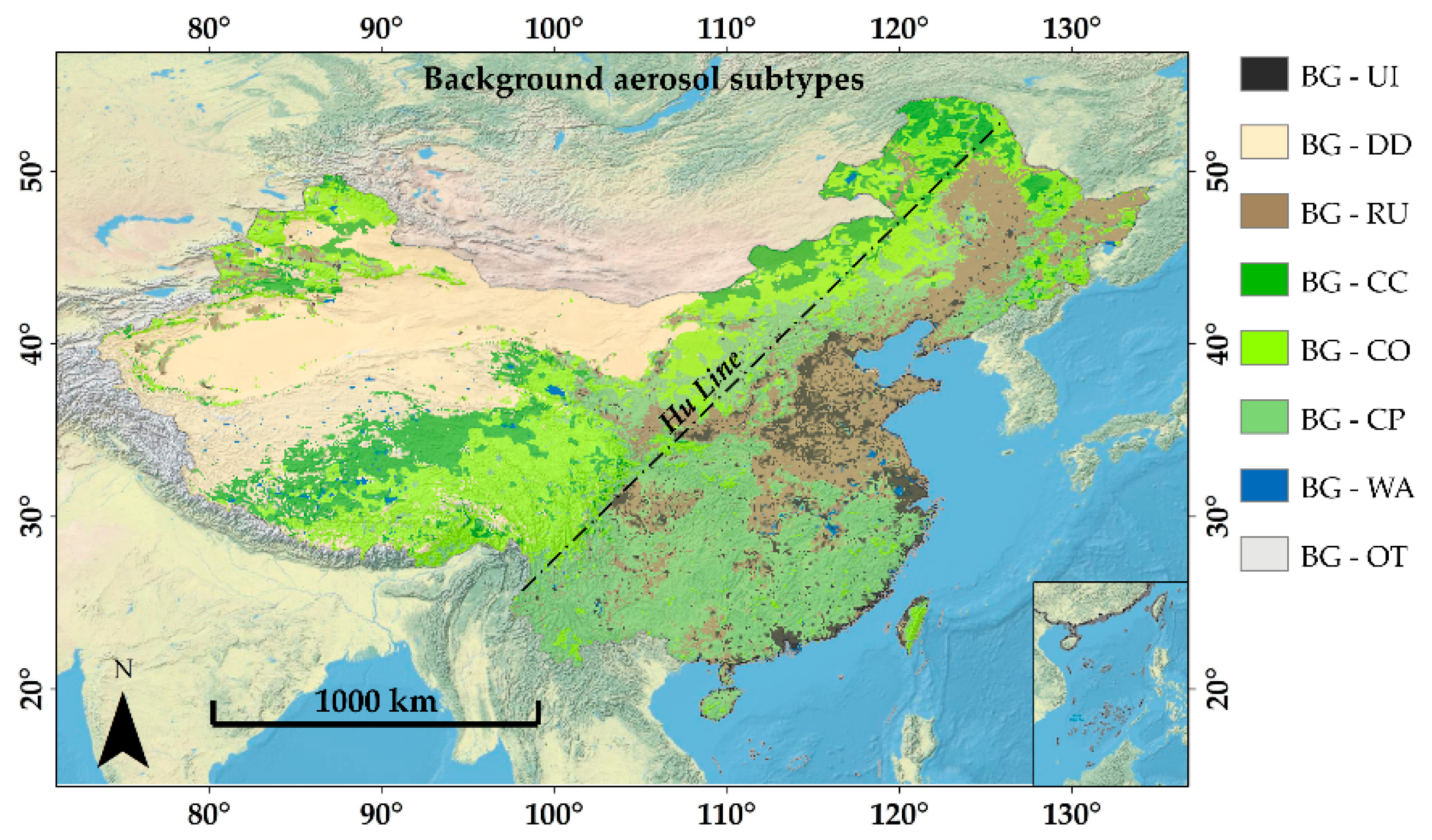
Figure 5 shows the classification of background aerosol subtypes across China at a resolution of 0.1° × 0.1°. We divided background aerosols into eight subtypes including background desert dust (BG-DD), background clean continent (BG-CC), background continent (BG-CO), background continental polluted (BG-CP), background rural (BG-RU), background urban/industry (BG-UI), background water (BG-WA), and other background aerosols (BG-OT). BG-DD aerosol represents the background type over barren areas containing sand, rock, and soil, which consist of many inorganic substances and mineral components [17,49]. It is mainly distributed in the desert areas in northwest China, for example, Taklamakan Desert and Gobi Desert. BG-CC aerosol has no or very low soot and is mainly composed of water-soluble particles. It denotes the background aerosol over vegetated lands with population density (PD) less than 1 per km2, like the middle of Tibetan Plateau and some remote grassland and forest in northeast China [22,42]. BG-CO aerosol is similar to BG-CC but with a higher PD between 1 and 25 per km2, namely, a higher level of anthropogenic emission. BG-CP aerosol represents the background subtypes for areas with much higher human population density (25 ≤ PD < 600) and it contains more than twice the soot and water-soluble components of BG-CO. It mainly distributes in populated mountain regions in eastern China. BG-RU aerosol represents the background aerosol type over cropland and natural vegetation mosaics with PD < 600 and contains more soot and water-soluble substances than BG-CP [14,50,51]. BG-RU mainly distributes over plains like Northeast China Plain, North China Plain, Middle and Lower Reaches Plain of Yangtze River, Upper and Middle Reaches Plains of Yellow River, and Chengdu Plain. BG-UI aerosol is background aerosol type over urban built-up lands as well as populated croplands and vegetated lands (PD > 600). It mainly consists of the combustion of coal and oil derivatives, and both water-soluble and insoluble substances are abundant [52,53]. BG-UI is mainly found in well-developed regions like provincial capitals and coastal regions like Yangtze Delta and Pearl River Delta. In addition, BG-WA represents background aerosols over water bodies and is scattered throughout China, like Qinghai Lake, Tai Lake, and Dongting Lake. BG-OT represents the background subtypes over permanent snow/ice and undefined lands and usually exists in the Himalaya regions.
It should be noted that the temporal variation of background aerosol subtypes was not taken into account during the studying period, because the land use and population density information varied negligibly during the studying period. The spatial distribution of background aerosol subtypes in Figure 5 gives a basic view of background aerosol conditions across China and will better help to catch aerosol variations in more detail than a unified “background” type over a wide terrain, especially for those regions without ground measurements and detailed studies.

3.2. Spatial Distribution of Dominant Aerosol Types over China

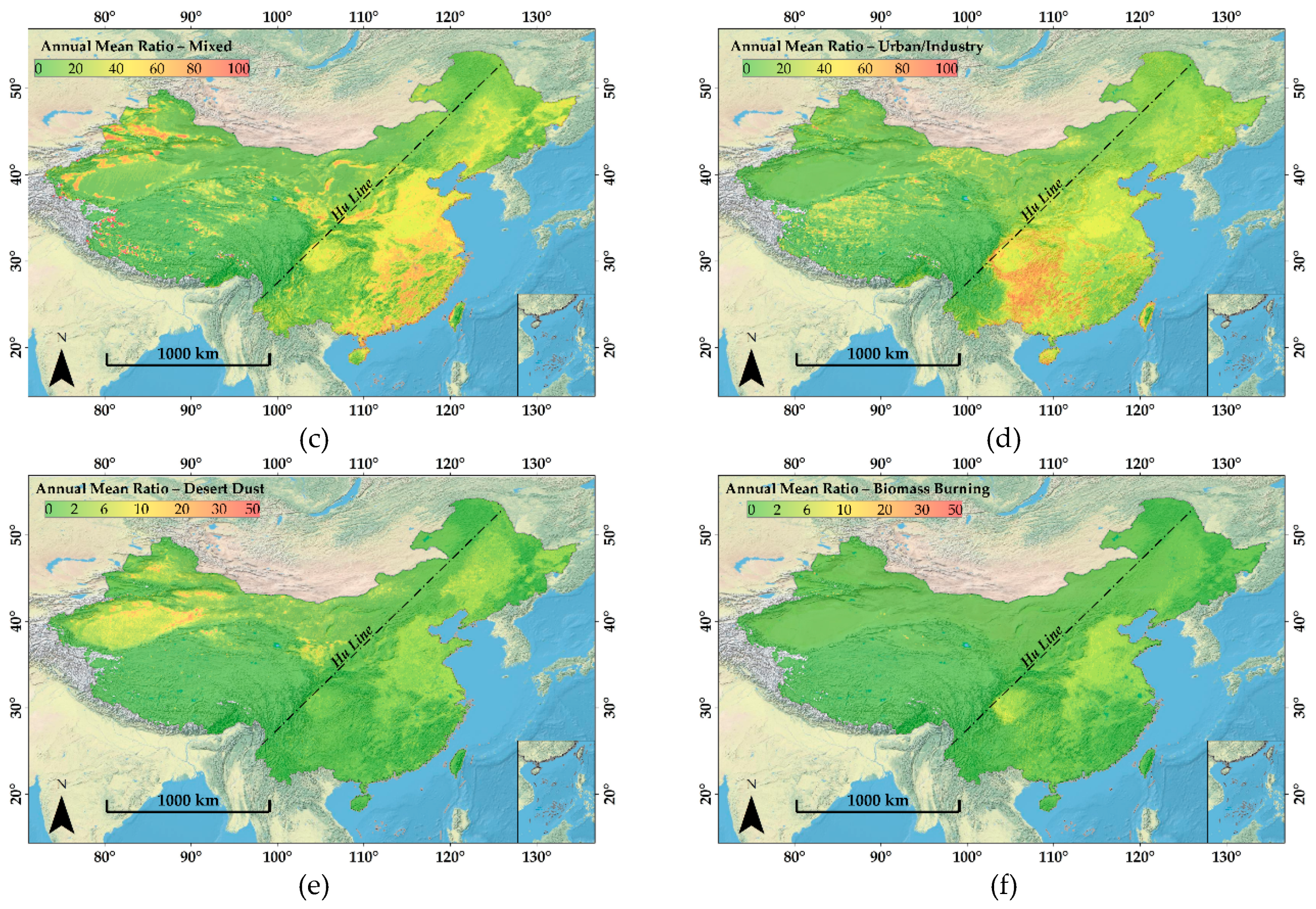
Figure 6a depicts the spatial distribution of dominant aerosol types over China between 2008 and 2017. Background aerosol dominates the west side of the Hu Line with an annual mean ratio over 70% (Figure 6b). BG-CC and BG-CO dominate the southwest China (mainly the Tibetan Plateau) and BG-DD is the major aerosol type in the northwest, for it is a desert region. The shift of dominant aerosol type from BG-PC and BG-RU in the west to UI and MIX in the east is mainly attributable to the increase of human activities [18]. MIX aerosols are mainly found over plains and coastal areas (Figure 6c). Generally, MIX aerosol in China can be divided into two subtypes. The first MIX subtype is the mixing of dust/desert dust aerosols with anthropogenic emissions, which are mostly found on the east side of the Hu Line with annual mean ratios of 60%–80% [14,54]. The second MIX subtype is the mixing of maritime aerosols with anthropogenic emissions and can be found over coastal areas with annual mean ratios over 70% [5]. However, due to the limitations from both retrieval algorithms and satellite sensors, it is currently impossible to make a clear separation between these two kinds of mixed types.
Urban/industrial aerosols are mainly observed over eastern China. From Figure 6d, annual mean ratio of UI aerosols over North China Plain (NCP) and Northeast China Plain (NECP) are between 20% and 30%, which is lower than that of MIX. Also, a large annual mean ratio of UI appears over Sichuan Basin, Guangxi, and coastal areas such as western Taiwan. Such a high annual mean ratio of UI may result from the synergistic effects of massive anthropogenic emissions and adverse geomorphology and meteorological conditions [55,56]. According to Figure 6e, the highest annual mean ratio of DD (~10%) is found over northwest deserts and the Hexi Corridor. NCP and NECP also have an annual mean ratio of around 5%, indicating a non-negligible climate and environment influence from the long-range transported DD particles [21,57]. From Figure 6f, most parts of the country are seldom dominated by significant BB aerosols. A high annual mean ratio of BB between 6%–10% was found over NCP and the Sichuan Basin, because these areas are important cultivated lands in China and straw burning often occurs in the harvest seasons, which leads to large biomass burning emissions and, thus, severe air pollutions [20,58].

3.3. Seasonal Variation of Dominant Aerosol Types over China

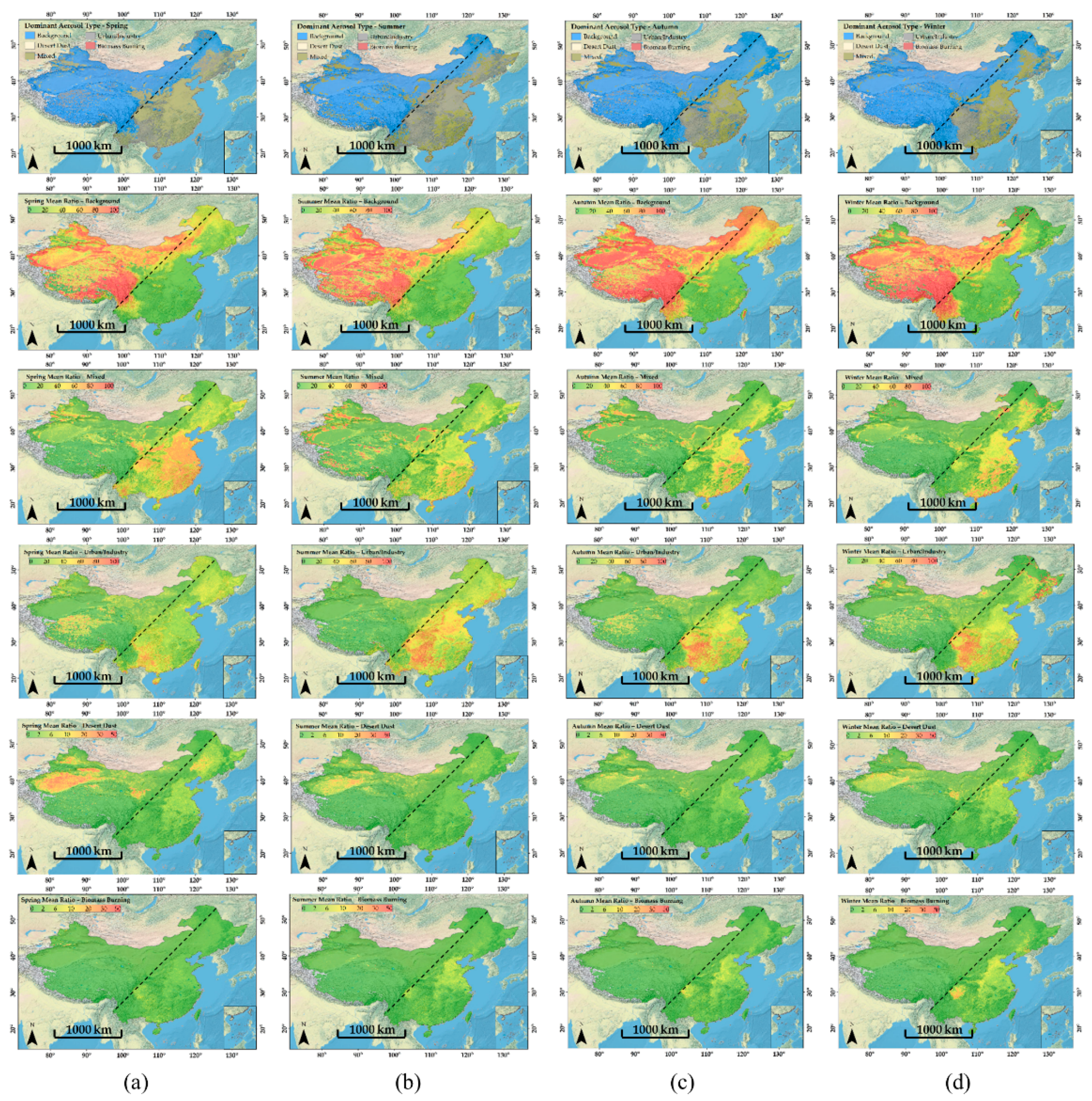
Figure 7 shows the seasonal variations of aerosol-type ratios and the seasonal distribution of dominant aerosol types can be found in Figure S2. The high spatial coverage of background aerosol is generally equivalent to widespread clean conditions. A distinct seasonal trend of aerosol types was observed. Generally, the spatial coverage of background aerosol across China is small in spring (March, April, May) and summer (June, July, August) but large in autumn (September, October, November) and winter (December, January, February). In eastern China, MIX aerosols dominate in spring while UI aerosols dominate in summer. In western China, BG aerosols dominate with little seasonal variation.
In spring, strong atmospheric movement brings large amounts of dust particles to eastern China and, thus, leads to an increase of AOD and also peak ratio and coverage of MIX aerosols (Figure 7) [16]. UI aerosol is the most widely distributed type in summer with seasonal mean ratio of over 60% in most areas, but its spatial coverage decreases significantly in other seasons (Figure S2b). Such a wide coverage of UI aerosol in summer is mainly due to strong atmospheric photochemical reactions [22,59]. Seasonal mean ratio of UI in Sichuan Basin, Guangxi, and Guizhou remained high, at over 50%, in all seasons. This can be attributed to two aspects. One is the massive anthropogenic emissions and the other is the special geomorphology of basins and valleys that hinders the dissipation of pollutants [55,60]. Furthermore, southern China tends to have a relatively higher temperature throughout the year, thus facilitating stronger photochemical reaction than the north [22]. BB aerosol can be sparsely observed in spring. BB aerosols generally occur in the Sichuan Basin and NCP and the seasonal mean ratio shows an increasing trend from less than 10% in summer to over 20% in winter (Figure 7). The highest ratio of BB in winter may be attributable to three aspects: (1) Residents burn straw to heat themselves in the cold weather [61], (2) people frequently burn paper money and fireworks around the Chinese Spring Festival to cherish the memory of ancestors at a national scale [60,62], (3) BB aerosols accumulate under the stable atmosphere in winter and the adverse weather condition hinders the dissipation of BB aerosols and increases the residence time of BB aerosols. Thus, BB ratio will increase [63,64]. The seasonal mean ratio of DD aerosol is high in spring and winter, reaching around 10% in regions most influenced by DD (Hexi corridor, NCP, and NECP). In the vicinity of the Hu Line, BG-CO, BG-CP, and BG-RU are dominant in winter and autumn but are replaced by MIX and UI in spring and summer. In North China Plain and Middle and Lower Reaches Plain of Yangtze River regions, MIX aerosol shows a seasonal mean ratio of over 30% in all seasons.

3.4. Inter-Annual Variation of Aerosol Types in Typical Regions over China

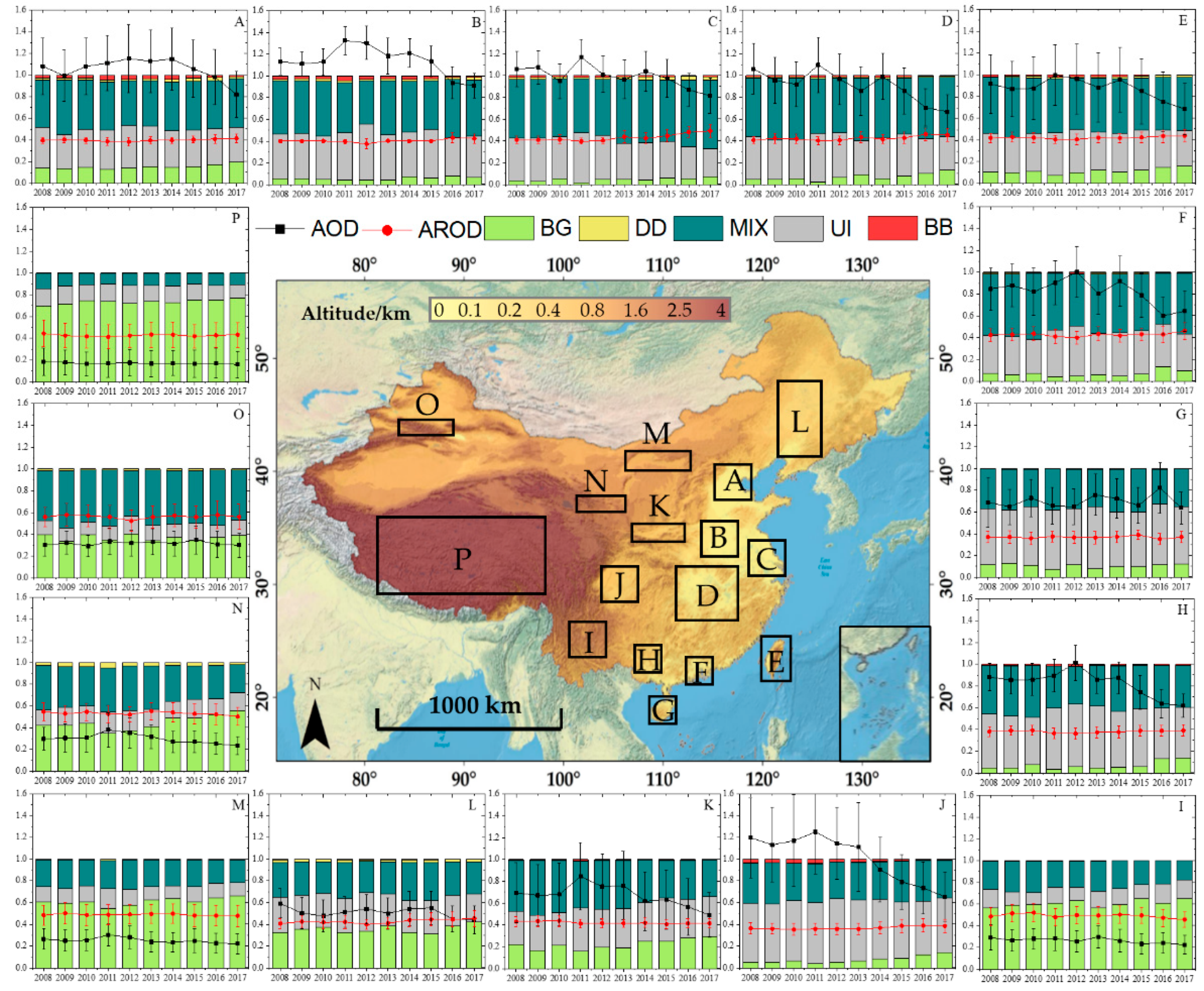
The temporal variation of aerosol types at 16 typical regions across China from 2008 to 2017 was statistically analyzed. Figure 8 shows the inter-annual variation of the occurrence ratio of different aerosol types (inter-seasonal variations can be found in Figures S3–S6). During the study period, the annual mean AOD on the east side of the Hu Line mostly showed a significant decreasing trend while those on the west side were stable with a mean value between 0.2 to 0.3 (Figure 8). The annual mean AROD values on the east side (around 0.4) are lower than those on the west side (around 0.5), indicating a higher percentage of coarse mode particles in remote areas [37,65]. In most selected typical regions, the proportion of background aerosols showed a clear upward trend, while that of UI and BB firstly increased and then decreased. The time point for the trend change was around 2013. Due to a severe winter haze-fog event throughout eastern China in 2013, a strict environmental protection law was promulgated rapidly by the state and executed strictly by local governments, which then led to the continuous decrease of aerosol loading as well as the proportion of UI and BB aerosols in the following years [39]. In addition, a notable increasing trend of DD was observed in NCP (A–D) and NECP (L) between 2013 and 2017.
Compared with the annual mean results, the proportions of MIX and DD aerosols underwent a visible increase by over 20% while the proportion of UI and BG decreased by 30% to 50% in A–E and J–O in spring throughout the study period (Figure S3). In regions F–I, the proportion of BG decreased because this region is far from the DD source and, thus, less influenced by dust particles. Those of UI and MIX, however, increased by 10%–20% because of the transport of the polluted aerosols from Southeast Asia [20,66]. In summer, annual mean AODs on the east side of the Hu Line are significantly higher than in other seasons (Figure S4). In some populated regions, such as A–E, the seasonal mean AOD even exceeds 2.0, indicating that photochemical reactions of anthropogenic aerosols are very strong in high temperature and humidity environments, thus producing a large amount of secondary aerosols [67]. The proportion of UI in densely populated areas is usually about 50% and even more than 70% in some areas such as regions B and J. In autumn, the temperature decrease is larger in the north than in the south, leading to the notable decrease of UI (Figure S5). On the west side of the Hu Line, MIX decreased and BG increased with a growing trend, indicating a lower aerosol loading compared with summer. Before 2013, the proportion of DD aerosols in A–E and LON areas, which are often affected by DD particles, was similar between winter and spring, ranging from 2% to 3% (Figure S6). However, after 2013, the proportion of dust aerosols in winter increased significantly and showed a trend of increasing gradually. On the whole, inter-seasonal variation of aerosol types is most significant in NCP and Sichuan Basin. Since a lot of research was conducted in the eastern part of China, like NCP, more attention should be focused on the central part of China, like Sichuan Basin.

3.5. Properties of Typical Aerosol Type over China

After obtaining a full view of aerosol-type distributions across China, we summarized the key properties of typical aerosol types from long-term observations as well as case studies over China. Table 2 shows the key aerosol properties of each type over China, and aerosol properties of similar type from clustering analysis using regional or global AERONET measurements are also listed. These key aerosol properties include SSA, real part of refractive index (RIR), imaginary part of refractive index (RII), volume concentration ratio of fine and coarse mode (C1/C2, assuming a bimodal log-normal size distribution), volume mean radius of fine and coarse mode (R1 and R2), and the log of the standard deviation for fine and coarse mode (D1 and D2). A total amount of 41 ground-based sites was involved here and detailed information of these datasets can be found in the supplementary material (Table S2).
For UI aerosol, the average SSA in China is 0.91, which is slightly lower than the global average of 0.92 and East Asian average of 0.93 [68,69]. The average RIR in China (1.46) is higher than the global average of 1.41, and RII (0.0110) is nearly twice the global average of 0.0063, indicating UI aerosol in China has stronger scattering and absorbing abilities than the world average. The average value of C1/C2 ranges from 0.6 to 1.8 with an average value of 1.27, and it was observed that coastal cities tend to have a higher C1/C2 value, like Guangzhou, Tianjin, and Chiayi, while inland regions have lower C1/C2 values. It should be noted that a summer case study in Shanghai characterized by ozone (O3) pollution has an extremely high C1/C2 value of 3, demonstrating that the strong photochemical reaction will significantly increase the amount of fine mode particles. For DD aerosol, the average SSA in China is lower than the world average. RIR and especially RII are much higher than the global average due to the abundant presence of light-absorbing mineral components in Asian dust, which leads to a low SSA value. The average value of C1/C2 is generally half of the global average, indicating there are many more coarse particles in dust events in China. The coarse mode particle radius is slightly higher than the global average. MIX aerosol, as we presented in Section 3.3, has two different type. In coastal cities like Zhoushan, where aerosol is the mixture of marine and urban/industrial particles, SSA has a quite high value of 0.95 and the radius for both fine mode and coarse mode is larger than the Asian average. As for inland cities, the MIX type should be the mixture of urban/industrial and dust/desert dust particles, and the average SSA (0.92) is a little bit lower than the coastal area. Such a decrease of SSA mainly comes from the increased presence of the light-absorbing dust particles. For BB aerosol, since there are few studies providing the aerosol properties, the recommended RI value in Table 2 came from Zhang’s clustering analysis [70], and the particle radius came from the case studies in Beijing and Nam Co.
For BG aerosol, the average RIR and RII is much higher than the global average. Apart from RIR and RII, the overall characteristics of BG in China is close to the global average in both SSA and size distribution. Although we refined the background aerosol subtypes for satellite remote sensing, the lack of ground-based sites in non-urban regions hindered us from obtaining convincible aerosol optical properties for each BG subtype. So, many BG aerosol properties in Table 2 came from very limited observations or references and the use of these values should be taken with care. The properties of BG-UI aerosol came from Zhang’s clustering analysis in Beijing, which is characterized by ‘traffic’. For BG-DD aerosol, since the aerosol loading is small, the C1/C2 value was set as 0.2. For BG-RU aerosol, we recommended a SSA value of 0.92, which is larger than Omar’s rural-type value of 0.88, and also a familiar high RII value of 0.0120. For continental aerosol, the difference mainly is in the amount of soot particles. So, we set that the CP had a larger RII value as well as a higher C1/C2, while CC had the smallest RII value. As for water body, the observation was extremely lacking. So, we set the annual mean value from Taihu site as the typical WA properties. Since OT was in a very small amount, we had to ignore it. In addition, we added a marine type here (BG-MA) to make our summary more comprehensive, but similar to BG-WA, we only had one ground observation dataset in Dongsha Island. So, we just set the mean value from Dongsha Island as the typical property for BG-MA. Again, we want to emphasize that some of the aerosol properties in Table 2 were not that convincible due to the lack of ground observations, and more effort should be made to achieve a better view of aerosol properties across China, especially in the central and western parts. Also, since AERONET can only provide key aerosol parameters like SSA and RI when AOD is larger than 0.4, aerosol properties in regions with low aerosol loading (e.g., oceans, the pole region, and remote areas like forest, grass land, and plateaus in western China), as well as their spatiotemporal variations, are barely understood. So, the development of remote sensing technique for retrieving SSA and RI under low aerosol loading is vitally important for us to catch the unique properties and spatiotemporal patterns of different aerosol types and loadings and, thus, further our understanding of the regional and global aerosol–climate effects.

4. Conclusions

This study investigated the spatiotemporal variation of aerosol types over China during the 10 years from 2008 to 2017 using the MODIS-Terra DT and DB AOD products as well as the MODIS land cover and SEDAC’s population density datasets. Two aerosol-classification methods, the AOD–AROD classification method and a background aerosol-subtype estimation method, were combined to depict the annual and seasonal aerosol-type map of China. Binomial extrapolation and AOD fusion scheme were conducted to obtain a broader spatiotemporal coverage of AROD and, accordingly, the aerosol types for pixels with AOD > 0.2 were classified via the AROD aerosol-classification scheme. Considering the ambiguity of satellite background aerosol identification, we classified pixels with AOD < 0.2 as a background type and developed a method to refine the background aerosol into eight subtypes, according to the land cover and population density information, to better characterize changes in aerosol types. Through the combined use of the two classification methods, we obtained the spatiotemporal characteristics of DD, MIX, UI, BB, and BG subtype aerosols and their variation trends during the study period. On the whole, a distinct spatiotemporal pattern of aerosol types was observed over China. On the western part of China, BG aerosols dominate this region with an average occurrence ratio over 70%, while on the eastern side, MIX and UI aerosols are the dominant aerosol types and their spatial coverages vary a lot due to the shift of emission sources (e.g., long-range transport dust from the west deserts in spring, and strong photochemical reactions in summer). In addition, we summarized the key aerosol properties for each aerosol type based on previous studies over China. Although the number of ground-based sites involved in the current study was limited to provide very representative aerosol properties, it was obvious that aerosol properties in China are different from the global average (e.g., higher RI values). To gain a more comprehensive view on the regional aerosol properties, more ground-based observation sites should be established, especially in central and western China, and the development of an inversion algorithm under low aerosol loading conditions should also be emphasized.
There are some assumptions and limitations in the current study. The first is that we assumed aerosols are closely related to local emissions and the background type was, accordingly, classified by land use and population density. The second is that we ignored the change of land cover during the studying period since our study domain was large and the change of land cover tends to be negligible to the domain scale. However, if one wants to study the aerosol-type change on a city scale, then the change of land cover should not be overlooked because the urbanization in China is rapid in recent years and, accordingly, the aerosol emission may change a lot. The third is the extrapolation for calculating AOD1020 using spectral AODs between 0.47 and 0.66 µm. In this study, we focused on the spectral difference of AODs, and the use of AOD1020/AOD440 was able to reflect the spectral trend of AODs. However, the extrapolation is not encouraged when AOD1020 serves as an independent parameter for research.
We hope that the aerosol-type maps and the aerosol properties provided by this study can serve as a reference for both regional aerosol–climate research and remote sensing algorithm developments.

Supplementary Materials

The following are available online at https://www.mdpi.com/2073-4433/11/7/703/s1. Figure S1: (a) MODIS land-type map from MCD12Q1 products and (b) GPWv4 population density over China. Figure S2: Spatial distribution of the dominant aerosol types and the mean ratios of different aerosol types in (a) spring MAM, (b) summer JJA, (c) autumn SON, and (d) winter DJF over China during 2008 to 2017. Figure S3: Temporal variation of aerosol types at 16 typical regions over China in spring during 2008 to 2017. Figures S4–S6 are similar to Figure S3 but in summer, autumn, and winter, respectively. Table S1: Basic information of the AERONET sites used for satellite AOD validation in this study. Table S2: Summary of aerosol optical and microphysical properties of different aerosol types in previous research. The determination of the population threshold value used in classifying background subtypes is presented after the tables. The evaluation of misclassification of background aerosols are discussed.

Author Contributions

Conceptualization, Q.-X.C. and Y.Y.; methodology, Q.-X.C.; software, Q.-X.C. and C.-L.H.; validation, Q.-X.C., Y.Y., and H.-P.T.; formal analysis, Q.-X.C.; investigation, Q.-X.C.; writing—original draft preparation, Q.-X.C.; writing—review and editing, Q.-X.C. and Q.-J.M.; visualization, Q.-X.C.; supervision, H.-P.T.; project administration, Y.Y.; funding acquisition, Y.Y. All authors have read and agreed to the published version of the manuscript.

Funding

This research was funded by National Natural Science Foundation of China, grant numbers 51776051 and 51876147.

Acknowledgments

We would like to thank the AERONET and MODIS teams as well as SEDAC for providing the data used in this study.

Conflicts of Interest

The authors declare no conflict of interest.

References

  1. Moosmüller, H.; Chakrabarty, R.K.; Arnott, W.P. Aerosol light absorption and its measurement: A review. J. Quant. Spectrosc. Radiat. Transf. 2009, 110, 844–878. [Google Scholar] [CrossRef]
  2. Yu, H.; Kaufman, Y.J.; Chin, M.; Feingold, G.; Remer, L.A.; Anderson, T.L.; Balkanski, Y.; Bellouin, N.; Boucher, O.; Christopher, S.; et al. A review of measurement-based assessments of the aerosol direct radiative effect and forcing. Atmos. Chem. Phys. 2006, 6, 666. [Google Scholar] [CrossRef] [Green Version]
  3. Rosenfeld, D.; Andreae, M.O.; Asmi, A.; Chin, M.; de Leeuw, G.; Donovan, D.P.; Kahn, R.; Kinne, S.; Kivekäs, N.; Kulmala, M.; et al. Global observations of aerosol-cloud-precipitation-climate interactions. Rev. Geophys. 2014, 52, 750–808. [Google Scholar] [CrossRef] [Green Version]
  4. Zhang, Q.; Jimenez, J.L.; Canagaratna, M.R.; Ulbrich, I.M.; Ng, N.L.; Worsnop, D.R.; Sun, Y. Understanding atmospheric organic aerosols via factor analysis of aerosol mass spectrometry: A review. Anal. Bioanal. Chem. 2011, 401, 3045–3067. [Google Scholar] [CrossRef] [PubMed] [Green Version]
  5. Li, Z.Q.; Xu, H.; Li, K.T.; Li, D.H.; Xie, Y.S.; Li, L.; Zhang, Y.; Gu, X.F.; Zhao, W.; Tian, Q.J.; et al. Comprehensive Study of Optical, Physical, Chemical, and Radiative Properties of Total Columnar Atmospheric Aerosols over China: An Overview of Sun–Sky Radiometer Observation Network (SONET) Measurements. Bull. Am. Meteorol. Soc. 2017, 99, 739–755. [Google Scholar] [CrossRef]
  6. Twomey, S. Aerosols, clouds and radiation. Atmos. Environ. Part A Gen. Top. 1991, 25, 2435–2442. [Google Scholar] [CrossRef]
  7. Fan, J.; Wang, Y.; Rosenfeld, D.; Liu, X. Review of Aerosol–Cloud Interactions: Mechanisms, Significance, and Challenges. J. Atmos. Sci. 2016, 73, 4221–4252. [Google Scholar] [CrossRef]
  8. Zhao, B.; Wang, Y.; Gu, Y.; Liou, K.-N.; Jiang, J.H.; Fan, J.; Liu, X.; Huang, L.; Yung, Y.L. Ice nucleation by aerosols from anthropogenic pollution. Nat. Geosci. 2019, 12, 602–607. [Google Scholar] [CrossRef]
  9. Levy, R.C.; Remer, L.A.; Kleidman, R.G.; Mattoo, S.; Ichoku, C.; Kahn, R.; Eck, T.F. Global evaluation of the Collection 5 MODIS dark-target aerosol products over land. Atmos. Chem. Phys. 2010, 10, 10399–10420. [Google Scholar] [CrossRef] [Green Version]
  10. Levy, R.; Mattoo, S.; Munchak, L.; Remer, L.; Sayer, A.M.; Patadia, F.; Hsu, N.C. The Collection 6 MODIS aerosol products over land and ocean. Atmos. Meas. Tech. 2013, 6, 2989. [Google Scholar] [CrossRef] [Green Version]
  11. Zhang, L.; Li, J. Variability of Major Aerosol Types in China Classified Using AERONET Measurements. Remote Sens. 2019, 11, 2334. [Google Scholar] [CrossRef] [Green Version]
  12. Zhu, J.; Xia, X.; Wang, J.; Che, H.; Chen, H.; Zhang, J.; Xu, X.; Levy, R.; Oo, M.; Holz, R.; et al. Evaluation of Aerosol Optical Depth and Aerosol Models from VIIRS Retrieval Algorithms over North China Plain. Remote Sens. 2017, 9, 432. [Google Scholar] [CrossRef] [PubMed] [Green Version]
  13. Cheng, T.H.; Gu, X.F.; Xie, D.H.; Li, Z.Q.; Yu, T.; Chen, X.F. Simultaneous retrieval of aerosol optical properties over the Pearl River Delta, China using multi-angular, multi-spectral, and polarized measurements. Remote Sens. Environ. 2011, 115, 1643–1652. [Google Scholar] [CrossRef]
  14. Zhang, M.; Ma, Y.; Gong, W.; Liu, B.; Shi, Y.; Chen, Z. Aerosol optical properties and radiative effects: Assessment of urban aerosols in central China using 10-year observations. Atmos. Environ. 2018, 182, 275–285. [Google Scholar] [CrossRef]
  15. Chen, Q.-X.; Yuan, Y.; Shuai, Y.; Tan, H.-P. Graphical aerosol classification method using aerosol relative optical depth. Atmos. Environ. 2016, 135, 84–91. [Google Scholar] [CrossRef]
  16. Ou, Y.; Zhao, W.; Wang, J.; Zhao, W.; Zhang, B. Characteristics of Aerosol Types in Beijing and the Associations with Air Pollution from 2004 to 2015. Remote Sens. 2017, 9, 898. [Google Scholar] [CrossRef]
  17. Schmeisser, L.; Andrews, E.; Ogren, J.A.; Sheridan, P.; Jefferson, A.; Sharma, S.; Kim, J.E.; Sherman, J.P.; Sorribas, M.; Kalapov, I.; et al. Classifying aerosol type using in situ surface spectral aerosol optical properties. Atmos. Chem. Phys. 2017, 17, 12097–12120. [Google Scholar] [CrossRef] [Green Version]
  18. Sogacheva, L.; Rodriguez, E.; Kolmonen, P.; Virtanen, T.H.; Saponaro, G.; de Leeuw, G.; Georgoulias, A.K.; Alexandri, G.; Kourtidis, K.; van Der A, R.J. Spatial and seasonal variations of aerosols over China from two decades of multi-satellite observations-Part 2: AOD time series for 1995–2017 combined from ATSR ADV and MODIS C6.1 and AOD tendency estimations. Atmos. Chem. Phys. 2018, 18, 16631–16652. [Google Scholar] [CrossRef] [Green Version]
  19. Zhu, J.; Che, H.; Xia, X.; Chen, H.; Goloub, P.; Zhang, W. Column-integrated aerosol optical and physical properties at a regional background atmosphere in North China Plain. Atmos. Environ. 2014, 84, 54–64. [Google Scholar] [CrossRef]
  20. Zhu, J.; Xia, X.; Che, H.; Wang, J.; Zhang, J.; Duan, Y. Study of aerosol optical properties at Kunming in southwest China and long-range transport of biomass burning aerosols from North Burma. Atmos. Res. 2016, 169, 237–247. [Google Scholar] [CrossRef]
  21. Chen, Q.; Yuan, Y.; Huang, X.; He, Z.; Tan, H. Assessment of column aerosol optical properties using ground-based sun-photometer at urban Harbin, Northeast China. J. Environ. Sci. 2018, 74, 50–57. [Google Scholar] [CrossRef] [PubMed]
  22. Che, H.; Qi, B.; Zhao, H.; Xia, X.; Eck, T.F.; Goloub, P.; Dubovik, O.; Estelles, V.; Cuevas-Agulló, E.; Blarel, L.; et al. Aerosol optical properties and direct radiative forcing based on measurements from the China Aerosol Remote Sensing Network (CARSNET) in eastern China. Atmos. Chem. Phys. 2018, 18, 405–425. [Google Scholar] [CrossRef] [Green Version]
  23. Huang, L.; Jiang, J.H.; Tackett, J.L.; Su, H.; Fu, R. Seasonal and diurnal variations of aerosol extinction profile and type distribution from CALIPSO 5-year observations. J. Geophys. Res. Atmos. 2013, 118, 4572–4596. [Google Scholar] [CrossRef]
  24. Zhao, B.; Jiang, J.H.; Diner, D.J.; Su, H.; Gu, Y.; Liou, K.-N.; Jiang, Z.; Huang, L.; Takano, Y.; Fan, X.; et al. Intra-annual variations of regional aerosol optical depth, vertical distribution, and particle types from multiple satellite and ground-based observational datasets. Atmos. Chem. Phys. 2018, 18, 11247–11260. [Google Scholar] [CrossRef] [Green Version]
  25. Kumar, K.R.; Kang, N.; Yin, Y. Classification of key aerosol types and their frequency distributions based on satellite remote sensing data at an industrially polluted city in the Yangtze River Delta, China. Int. J. Climatol. 2018, 38, 320–336. [Google Scholar] [CrossRef]
  26. Gu, Y.; Liou, K.N.; Xue, Y.; Mechoso, C.R.; Li, W.; Luo, Y. Climatic effects of different aerosol types in China simulated by the UCLA general circulation model. J. Geophys. Res. Atmos. 2006, 111. [Google Scholar] [CrossRef] [Green Version]
  27. Kim, M.; Kim, J.; Wong, M.S.; Yoon, J.; Lee, J.; Wu, D.; Chan, P.W.; Nichol, J.E.; Chung, C.-Y.; Ou, M.-L. Improvement of aerosol optical depth retrieval over Hong Kong from a geostationary meteorological satellite using critical reflectance with background optical depth correction. Remote Sens. Environ. 2014, 142, 176–187. [Google Scholar] [CrossRef] [Green Version]
  28. Zhang, H.; Kondragunta, S.; Laszlo, I.; Liu, H.; Remer, L.A.; Huang, J.; Superczynski, S.; Ciren, P. An enhanced VIIRS aerosol optical thickness (AOT) retrieval algorithm over land using a global surface reflectance ratio database. J. Geophys. Res. Atmos. 2016, 121, 10–717. [Google Scholar] [CrossRef]
  29. Kalapureddy, M.C.R.; Kaskaoutis, D.G.; Ernest Raj, P.; Devara, P.C.S.; Kambezidis, H.D.; Kosmopoulos, P.G.; Nastos, P.T. Identification of aerosol type over the Arabian Sea in the premonsoon season during the Integrated Campaign for Aerosols, Gases and Radiation Budget (ICARB). J. Geophys. Res. Atmos. 2009, 114. [Google Scholar] [CrossRef] [Green Version]
  30. Patel, P.N.; Dumka, U.C.; Babu, K.N.; Mathur, A.K. Aerosol characterization and radiative properties over Kavaratti, a remote island in southern Arabian Sea from the period of observations. Sci. Total Environ. 2017, 599, 165–180. [Google Scholar] [CrossRef]
  31. Dubovik, O.; Holben, B.; Eck, T.F.; Smirnov, A.; Kaufman, Y.J.; King, M.D.; Tanré, D.; Slutsker, I. Variability of Absorption and Optical Properties of Key Aerosol Types Observed in Worldwide Locations. J. Atmos. Sci. 2002, 59, 590–608. [Google Scholar] [CrossRef]
  32. Giles, D.M.; Sinyuk, A.; Sorokin, M.G.; Schafer, J.S.; Smirnov, A.; Slutsker, I.; Eck, T.F.; Holben, B.N.; Lewis, J.R.; Campbell, J.R.; et al. Advancements in the Aerosol Robotic Network (AERONET) Version 3 database – automated near-real-time quality control algorithm with improved cloud screening for Sun photometer aerosol optical depth (AOD) measurements. Atmos. Meas. Tech. 2019, 12, 169–209. [Google Scholar] [CrossRef] [Green Version]
  33. Kahn, R.; Yu, H.; Schwartz, S.; Chin, M.; Feingold, G.; Remer, L.; Rind, D.; Halthore, R.; DeCola, P. Atmospheric Aerosol Properties and Climate Impacts; National Aeronautics and Space Administration: Washington, DC, USA, 2009.
  34. Cohen, J.B.; Lecoeur, E.; Hui Loong Ng, D. Decadal-scale relationship between measurements of aerosols, land-use change, and fire over Southeast Asia. Atmos. Chem. Phys. 2017, 17, 721–743. [Google Scholar] [CrossRef] [Green Version]
  35. Lin, C.; Cohen, J.B.; Wang, S.; Lan, R. Application of a combined standard deviation and mean based approach to MOPITT CO column data, and resulting improved representation of biomass burning and urban air pollution sources. Remote Sens. Environ. 2020, 241, 111720. [Google Scholar] [CrossRef]
  36. Pan, X.L.; Kanaya, Y.; Wang, Z.F.; Liu, Y.; Pochanart, P.; Akimoto, H.; Sun, Y.L.; Dong, H.B.; Li, J.; Irie, H.; et al. Correlation of black carbon aerosol and carbon monoxide in the high-altitude environment of Mt. Huang in Eastern China. Atmos. Chem. Phys. 2011, 11, 9735–9747. [Google Scholar] [CrossRef] [Green Version]
  37. Chen, Q.X.; Shen, W.X.; Yuan, Y.; Xie, M.; Tan, H.P. Inferring Fine-Mode and Coarse-Mode Aerosol Complex Refractive Indices from AERONET Inversion Products over China. Atmosphere 2019, 10, 158. [Google Scholar] [CrossRef] [Green Version]
  38. Mso, Q.J.; Huang, C.L.; Chen, Q.X.; Zhang, H.X.; Yuan, Y. Satellite-based identification of aerosol particle species using a 2D-space aerosol classification model. Atmos. Environ. 2019, 219, 117057–117069. [Google Scholar] [CrossRef]
  39. He, Q.Q.; Gu, Y.F.; Zhang, M. Spatiotemporal patterns of aerosol optical depth throughout China from 2003 to 2016. Sci. Total Environ. 2019, 653, 23–35. [Google Scholar] [CrossRef]
  40. Song, Z.; Fu, D.; Zhang, X.; Wu, Y.; Xia, X.; He, J.; Han, X.; Zhang, R.; Che, H. Diurnal and seasonal variability of PM2.5 and AOD in North China plain: Comparison of MERRA-2 products and ground measurements. Atmos. Environ. 2018, 191, 70–78. [Google Scholar] [CrossRef]
  41. Li, J.; Li, Y.; Bo, Y.; Xie, S. High-resolution historical emission inventories of crop residue burning in fields in China for the period 1990–2013. Atmos. Environ. 2016, 138, 152–161. [Google Scholar] [CrossRef]
  42. Wan, X.; Kang, S.; Wang, Y.; Xin, J.; Liu, B.; Guo, Y.; Wen, T.; Zhang, G.; Cong, Z. Size distribution of carbonaceous aerosols at a high-altitude site on the central Tibetan Plateau (Nam Co Station, 4730ma.s.l.). Atmos. Res. 2015, 153, 155–164. [Google Scholar] [CrossRef]
  43. Mhawish, A.; Banerjee, T.; Broday, D.; Misra, A.; Tripathi, S. Evaluation of MODIS Collection 6 aerosol retrieval algorithms over Indo-Gangetic Plain: Implications of aerosols types and mass loading. Remote Sens. Environ. 2017, 201, 297–313. [Google Scholar] [CrossRef]
  44. Gridded Population of the World (GPW), v4. Available online: https://sedac.ciesin.columbia.edu/data/collection/gpw-v4 (accessed on 22 June 2020).
  45. Omar, A.H.; Won, J.G.; Winker, D.M.; Yoon, S.C.; Dubovik, O.; McCormick, M.P. Development of global aerosol models using cluster analysis of Aerosol Robotic Network (AERONET) measurements. J. Geophys. Res. Atmos. 2005, 110. [Google Scholar] [CrossRef]
  46. Che, H.; Zhang, X.; Xia, X.; Goloub, P.; Holben, B.; Zhao, H.; Wang, Y.; Wang, H.; Blarel, L.; Damiri, B.; et al. Ground-based aerosol climatology of China: Aerosol optical depths from the China Aerosol Remote Sensing Network (CARSNET) 2002–2013. Atmos. Chem. Phys. Discuss. 2015, 15, 7619. [Google Scholar] [CrossRef] [Green Version]
  47. NT, O.N.; Ignatov, A.; Holben, B.N.; Eck, T.F. The lognormal distribution as a reference for reporting aerosol optical depth statistics; Empirical tests using multi-year, multi-site AERONET Sunphotometer data. Geophys. Res. Lett. 2000, 27, 3333–3336. [Google Scholar] [CrossRef]
  48. Bilal, M.; Nichol, J.E.; Wang, L. New customized methods for improvement of the MODIS C6 Dark Target and Deep Blue merged aerosol product. Remote Sens. Environ. 2017, 197, 115–124. [Google Scholar] [CrossRef]
  49. Su, X.; Wang, Q.; Li, Z.; Calvello, M.; Esposito, F.; Pavese, G.; Lin, M.; Cao, J.; Zhou, C.; Li, D.; et al. Regional transport of anthropogenic pollution and dust aerosols in spring to Tianjin—A coastal megacity in China. Sci. Total Environ. 2017, 584–585, 381–392. [Google Scholar] [CrossRef]
  50. Hess, M.; Koepke, P.; Schult, I. Optical Properties of Aerosols and Clouds: The Software Package OPAC. Bull. Am. Meteorol. Soc. 1998, 79, 831–844. [Google Scholar] [CrossRef]
  51. Xie, Y.; Li, D.; Xu, H.; Li, K. Aerosol Optical and Microphysical Properties of Four Typical Sites of SONET in China Based on Remote Sensing Measurements. Remote Sens. 2015, 7, 9928–9953. [Google Scholar] [CrossRef] [Green Version]
  52. Liu, C.; Yang, L.; Che, H.; Xia, X.; Zhao, H.; Wang, H.; Gui, K.; Zheng, Y.; Sun, T.; Li, X.; et al. Aerosol Optical Properties over an Urban Site in Central China Determined Using Ground-Based Sun Photometer Measurements. Aerosol Air Qual. Res. 2019, 19, 620–638. [Google Scholar] [CrossRef]
  53. Yu, X.; Lü, R.; Liu, C.; Yuan, L.; Shao, Y.; Zhu, B.; Lei, L. Seasonal variation of columnar aerosol optical properties and radiative forcing over Beijing, China. Atmos. Environ. 2017, 166, 340–350. [Google Scholar] [CrossRef]
  54. Wang, L.; Gong, W.; Xia, X.; Zhu, J.; Li, J.; Zhu, Z. Long-term observations of aerosol optical properties at Wuhan, an urban site in Central China. Atmos. Environ. 2015, 101, 94–102. [Google Scholar] [CrossRef]
  55. Tian, P.; Cao, X.; Zhang, L.; Sun, N.; Sun, L.; Logan, T.; Shi, J.; Wang, Y.; Ji, Y.; Lin, Y.; et al. Aerosol vertical distribution and optical properties over China from long-term satellite and ground-based remote sensing. Atmos. Chem. Phys. 2017, 17, 2509–2523. [Google Scholar] [CrossRef] [Green Version]
  56. Zhang, Y.; Li, Z.; Cuesta, J.; Li, D.; Wei, P.; Xie, Y.; Li, L. Aerosol Column Size Distribution and Water Uptake Observed during a Major Haze Outbreak over Beijing on January 2013. Aerosol Air Qual. Res. 2015, 15, 945–957. [Google Scholar] [CrossRef] [Green Version]
  57. Liu, J.; Zheng, Y.; Li, Z.; Flynn, C.; Welton, E.J.; Cribb, M. Transport, vertical structure and radiative properties of dust events in southeast China determined from ground and space sensors. Atmos. Environ. 2011, 45, 6469–6480. [Google Scholar] [CrossRef]
  58. Yu, X.; Shi, C.; Ma, J.; Zhu, B.; Li, M.; Wang, J.; Yang, S.; Kang, N. Aerosol optical properties during firework, biomass burning and dust episodes in Beijing. Atmos. Environ. 2013, 81, 475–484. [Google Scholar] [CrossRef]
  59. Shi, C.; Wang, S.; Liu, R.; Zhou, R.; Li, D.; Wang, W.; Cheng, T.; Zhou, B. A study of aerosol optical properties during ozone pollution episodes in 2013 over Shanghai, China. Atmos. Res. 2015, 153, 235–249. [Google Scholar] [CrossRef]
  60. Zhao, H.; Che, H.; Wang, Y.; Dong, Y.; Ma, Y.; Li, X.; Hong, Y.; Yang, H.; Liu, Y.; Wang, Y.; et al. Aerosol Vertical Distribution and Typical Air Pollution Episodes over Northeastern China during 2016 Analyzed by Ground-based Lidar. Aerosol Air Qual. Res. 2018, 18, 918–937. [Google Scholar] [CrossRef]
  61. Yu, M.; Yuan, X.; He, Q.; Yu, Y.; Cao, K.; Yang, Y.; Zhang, W. Temporal-spatial analysis of crop residue burning in China and its impact on aerosol pollution. Environ. Pollut. 2019, 245, 616–626. [Google Scholar] [CrossRef]
  62. Zheng, Y.; Che, H.; Xia, X.; Wang, Y.; Zhao, H.; Wang, H.; Estellés, V.; An, L.; Gui, K.; Sun, T.; et al. A Comparative Analysis of Aerosol Microphysical, Optical and Radiative Properties during the Spring Festival Holiday over Beijing and Surrounding Regions. Aerosol Air Qual. Res. 2018, 18, 1774–1784. [Google Scholar] [CrossRef] [Green Version]
  63. Huang, X.; Wang, Z.; Ding, A. Impact of Aerosol-PBL Interaction on Haze Pollution: Multiyear Observational Evidences in North China. Geophys. Res. Lett. 2018, 45, 8596–8603. [Google Scholar] [CrossRef] [Green Version]
  64. Zhong, J.; Zhang, X.; Wang, Y.; Wang, J.; Shen, X.; Zhang, H.; Wang, T.; Xie, Z.; Liu, C.; Zhang, H.; et al. The two-way feedback mechanism between unfavorable meteorological conditions and cumulative aerosol pollution in various haze regions of China. Atmos. Chem. Phys. 2019, 19, 3287–3306. [Google Scholar] [CrossRef] [Green Version]
  65. Chen, Q.X.; Shen, W.X.; Yuan, Y.; Tan, H.P. Verification of aerosol classification methods through satellite and ground-based measurements over Harbin, Northeast China. Atmos. Res. 2019, 216, 167–175. [Google Scholar] [CrossRef]
  66. Xu, J.; Szyszkowicz, M.; Jovic, B.; Cakmak, S.; Austin, C.C.; Zhu, J.P. Aerosol types types and radiative forcing estimates over East Asia. Atmos. Environ. 2016, 141, 532–541. [Google Scholar] [CrossRef]
  67. Pan, X.L.; Ge, B.Z.; Wang, Z.; Tian, Y.; Liu, H.; Wei, L.F.; Yue, S.Y.; Uno, I.; Kobayashi, H.; Nishizawa, T.; et al. Synergistic effect of water-soluble species and relative humidity on morphological changes in aerosol particles in the Beijing megacity during severe pollution episodes. Atmos. Chem. Phys. 2019, 19, 219–232. [Google Scholar] [CrossRef] [Green Version]
  68. Xu, X.Z.; Zhao, W.X.; Qian, X.D.; Wang, S.; Fang, B.; Zhang, Q.L.; Zhang, W.J.; Venables, D.S.; Chen, W.D.; Huang, Y.; et al. The influence of photochemical aging on light absorption of atmospheric black carbon and aerosol single-scattering albedo. Atmos. Chem. Phys. 2018, 18, 16829–16844. [Google Scholar] [CrossRef] [Green Version]
  69. Lee, K.H.; Kim, Y.J. Satellite remote sensing of Asian aerosols: A case study of clean, polluted, and Asian dust storm days. Atmos. Meas. Tech. 2010, 3, 1771–1784. [Google Scholar] [CrossRef] [Green Version]
  70. Zhang, W.H.; Xu, H.; Zheng, F.J. Classifying Aerosols Based on Fuzzy Clustering and Their Optical and Microphysical Properties Study in Beijing, China. Adv. Meteorol. 2017, 2017, 4197652. [Google Scholar] [CrossRef] [Green Version]
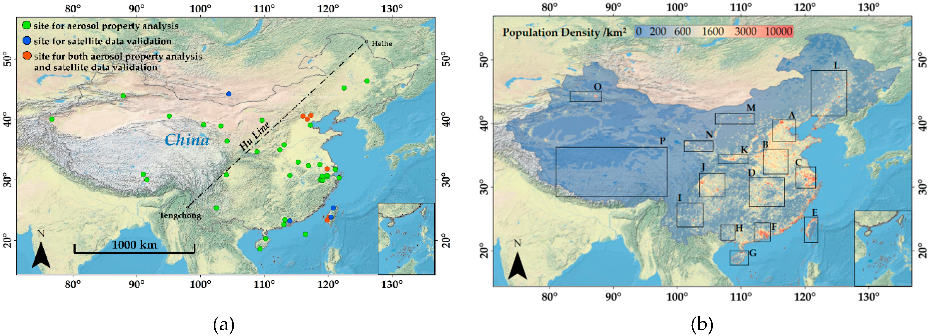
Figure 1. Map of (a) study domain and the distribution of the AERONET sites involved in this study and (b) population density and the geographical locations of 16 selected regions. In Figure 1a, green, blue, and orange dots represent the ground-based sites used for aerosol property analysis, satellite data validation, and both aerosol property analysis and satellite data validation, respectively. The black dotted line is the Hu Line (also known as Heihe-Tengchong Line).
Atmosphere 11 00703 g001
Figure 2. Aerosol-type classification methods used in this study. (a) A modified Aerosol optical Depth (AOD) – Aerosol Relative optical Depth AROD aerosol-classification method. BG, DD, MIX, UI, and BB denote the background, dust/desert dust, mixed, urban/industry, and biomass burning aerosols. (b) A background aerosol-subtype classification method was used to refine the BG aerosol type in (a). When AOD0.44 was less than 0.2, BG-UI, BG-DD, BG-RU, BG-CC, BG-CO, BG-CP, BG-WA, and BG-OT represent the background aerosol subtypes of urban/industry, dust/desert dust, rural, continental clean, continental, continental polluted, water body, and other aerosol types, respectively.
Atmosphere 11 00703 g002
Figure 3. Evaluation of extrapolated and merged MODIS (a) AOD440 and (b) AOD1020 against the AERONET observations. The dashed lines are the EE lines and the solid line is 1:1 line. R, N, RMSE, and RMB represent the correlation coefficient, number of observations, root mean square error, and relative mean bias and EE denotes the expected error.
Atmosphere 11 00703 g003
Figure 4. Flowchart of the data processing and aerosol-type classification in this study.
Atmosphere 11 00703 g004
Figure 5. Spatial distribution of background aerosol subtypes over China. BG- UI, BG-DD, BG-RU, BG-CC, BG-CO, BG-CP, BG-WA, and BG-OT represent the background aerosol subtypes of urban/industry, dust/desert dust, rural, continental clean, continental, continental polluted, water body, and other aerosol types, respectively.
Atmosphere 11 00703 g005
Figure 6. Spatial distribution of (a) the dominant aerosol types and the annual mean ratios of (b) background, (c) mixed, (d) urban/industry, (e) desert dust, and (f) biomass burning aerosols over China from 2008 to 2017.
Atmosphere 11 00703 g006aAtmosphere 11 00703 g006b
Figure 7. Spatial distribution of the dominant aerosol types and the mean ratios of different aerosol types in (a) spring March-April-May (MAM), (b) summer June-July- August (JJA), (c) autumn September-October-November (SON), and (d) winter December-January- February (DJF) over China during 2008 to 2017.
Atmosphere 11 00703 g007
Figure 8. Decadal variation of aerosol types at 16 typical regions over China during 2008 to 2017.
Atmosphere 11 00703 g008
Table 1. Selected regions used for analyzing the temporal variations of aerosol types over China from 2008 to 2017.
RegionNameLongitude (°)Latitude (°)
ABeijing-Tianjin-Hebei36.5°N–40.1°N114.5°E–118.0°E
Bthe Central Plain32.5°N–35.5°N113.0°E–117.5°E
CYangtze River Delta30.5°N–33.0°N118.5°E–122.0°E
DHunan and Hubei Province27.5°N–31.0°N111.7°E–116.5°E
EChinese Taiwan21.5°N–25.5°N119.5°E–112.5°E
FPearl River Delta21.5°N–23.7°N112.5°E–114.5°E
GHainan Province18.0°N–20.0°N108.5°E–111.1°E
HGuangxi Province21.5°N–25.5°N107.5°E–111°E
IYunnan Province23.0°N–27.5°N101.0°E–104°E
JSichuan Basin28.5°N–32.0°N103.5°E–108.5°E
KCentral Shaanxi Plain34.0°N–35.5°N107.0°E–111.5°E
LNortheast China Plain40.6°N–47.5°N121.5°E–128°E
MCentral and Western Inner Mongolia40.0°N–41.3°N106.8°E–112.5°E
NUpstream of the Yellow River35.5°N–37.0°N101.5°E–104.0°E
ONorthern Piedmonts of Tianshan Mountains43.5°N–44.5°N84.5°E–87.7°E
PTibetan Plateau28.0°N–35.5°N80.0°E–93.0°E
Table 2. Summary of aerosol properties for different types in China.
TypeSSARIRRIIC1/C2R1D1R2D2ReferenceData Source
UI0.911.460.01101.270.190.543.080.63This studyChina
0.921.410.00631.130.160.423.550.73Omar et al., 2005 [45]Global
0.931.480.00991.420.260.542.580.57Lee et al., 2010 [69]East Asia
DD0.911.570.00700.120.120.513.060.65This studyChina
0.931.450.00720.290.120.402.830.65Omar et al., 2005 [45]Global
0.891.50.00700.200.150.522.350.60Zhang et al., 2017 [70]China, Beijing
MIX(MA+UI)0.951.480.011.300.190.512.960.64This study *China, coastal
MIX(DD+UI)0.921.500.00851.280.150.482.520.65This study *China
0.901.550.00490.130.130.622.240.53Lee et al., 2010 [69]East Asia
0.881.510.01400.500.160.482.710.65Zhang et al., 2017 [70]China, Beijing
BB0.891.480.02301.250.170.514.010.63This study *China
0.91.440.01271.050.190.502.920.62Lee et al., 2010 [69]East Asia
0.841.480.02300.820.160.512.790.63Zhang et al., 2017 [70]China, Beijing
BG-UI0.921.440.00701.780.260.572.940.55Zhang et al., 2017 * [70]China, Beijing
BG-DD0.941.570.00800.140.160.522.520.64This study *China
BG-CC0.941.480.00601.100.160.513.960.63This study *China
BG-CO0.931.480.00751.250.160.512.840.63This study *China
BG-CP0.921.480.00801.500.160.512.760.63This study *China
BG-RU0.901.430.01201.000.170.502.730.60Zhang et al., 2017 * [70]China, Beijing
BG-WA0.931.440.00720.940.190.492.840.64This study *China, Taihu
BG-MA0.951.430.00601.210.210.482.870.63This study *China, Dongsha Island
BG0.911.480.00800.940.170.522.720.63This studyChina
BG0.931.390.00440.350.170.483.270.69Omar et al., 2005 [45]Global
Note: UI, DD, MIX, BB, and MA represent urban/industry, dust/desert dust, mixed, biomass burning, and marine aerosol types. BG-UI, BG-DD, BG-RU, BG-CC, BG-CO, BG-CP, BG-WA, and BG-MA represent the background aerosol subtypes of urban/industry, dust/desert dust, rural, continental clean, continental, continental polluted, water body, and marine aerosol types, respectively. SSA, RIR, and RII are the single scattering albedo, real part of refractive index, and imaginary part of refractive index. C1/C2, R1 and R2, and D1 and D2 are the volume concentration ratio of fine and coarse mode (assuming a bimodal log-normal size distribution), volume mean radius of fine and coarse mode, and the log of the standard deviation for fine and coarse mode, respectively. The * represents that the aerosol properties came from limited ground-based observations and was of low confidence. Usage of these data should be considered carefully.