Air-Traffic Restrictions at the Madeira International Airport Due to Adverse Winds: Links to Synoptic-Scale Patterns and Orographic Effects
Abstract
:1. Introduction
2. Data and Methods
2.1. Observations
2.2. Weather Typing and Reanalysis Data
2.3. AROME Model
3. Results and Discussion
3.1. Wind Regime at Madeira Island
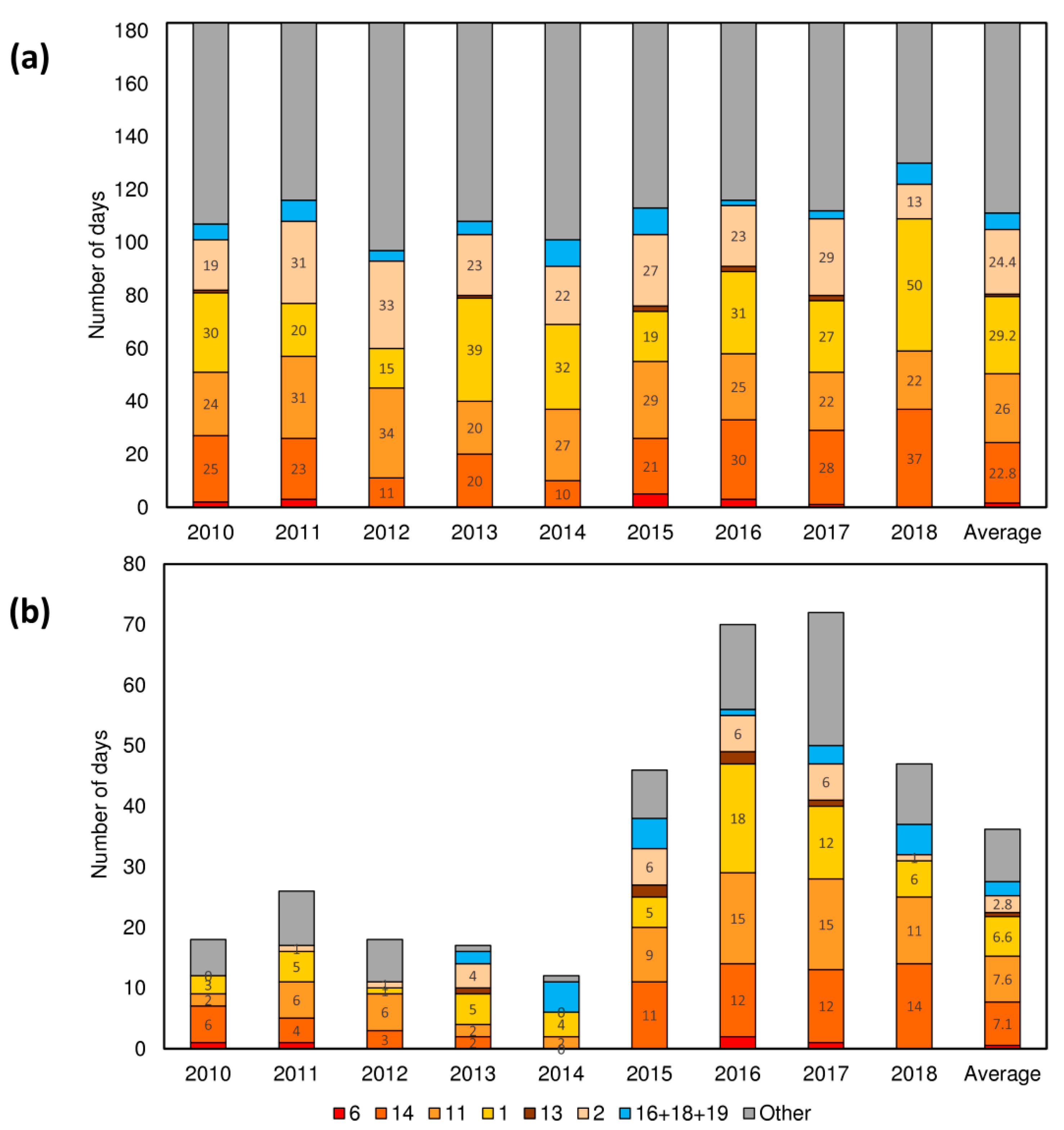
3.2. Weather Types and Their Connection between Restriction of Landing and Take-Off Operations Due to Wind Limitations
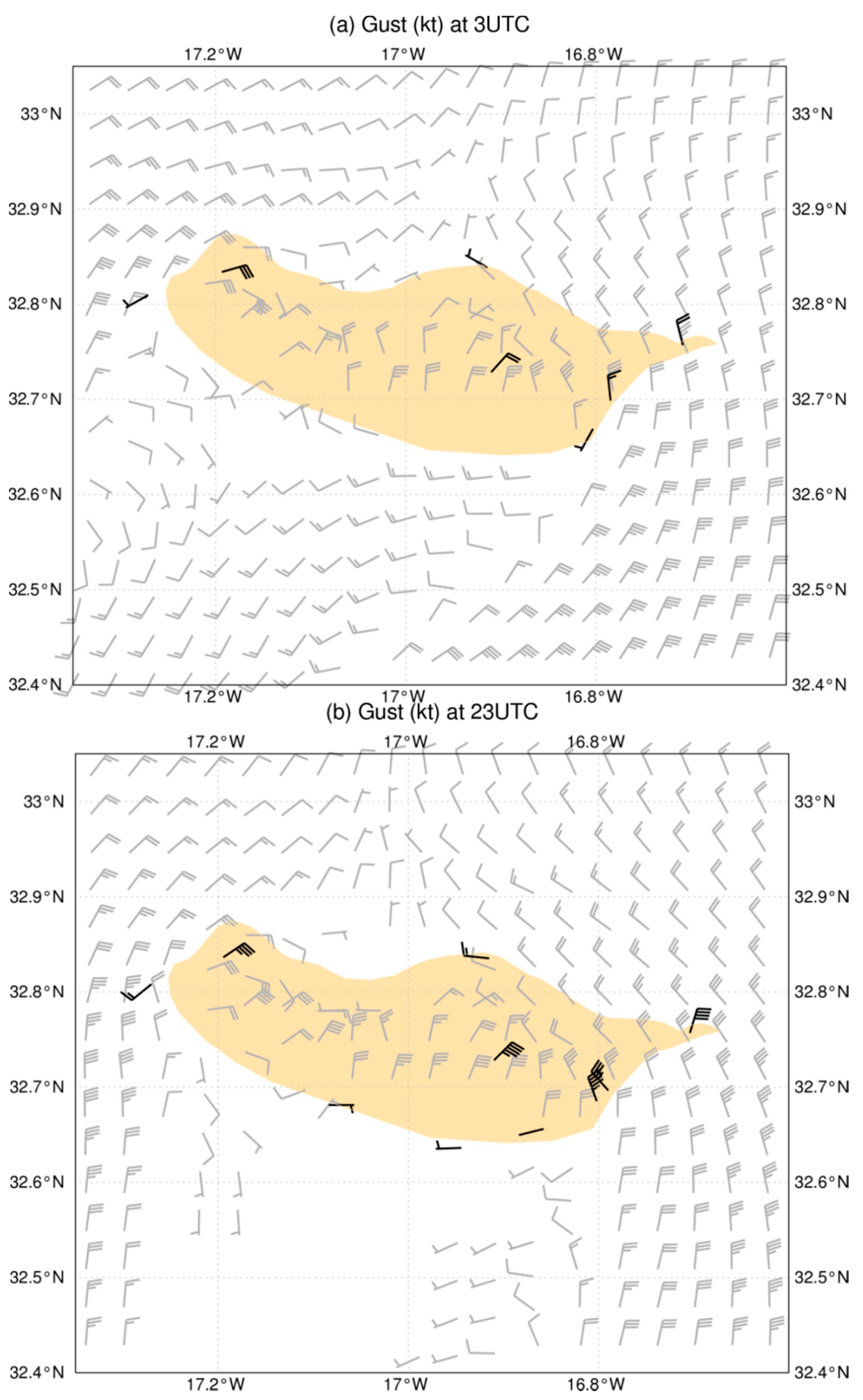
3.3. A Case Study Analysis
3.3.1. Upstream Conditions and Flow Splitting
3.3.2. Vertical Structure
3.4. Model Verification
4. Summary and Conclusions
Supplementary Materials
Author Contributions
Funding
Acknowledgments
Conflicts of Interest
Appendix A
- In the sector 300° to 015° (clockwise), the maximum of two-minutes average wind speed (WS2m) should be inferior to 15 kt and the wind gust should be inferior to 25 kt at the touchdown site. Here, the wind direction refers to the magnetic wind direction.
- In the sector 015° to 040° (clockwise) WS2m < 20 kt and maximum wind gust should be inferior to 30 kt at the touchdown site.
- In the sector 120° to 190° (clockwise):
- ○
- if the Runway in use is 05, WS2m < 20 kt and maximum wind gust should be inferior to 30 kt;
- ○
- if the Runway in use is 23, WS2m < 15 kt and maximum wind gust should be inferior to 25 kt also at MID.
- In the Sector 200° to 230° (clockwise) WS2m and the gust indicated by the MID or RS anemometer should be inferior to 25 kt.
- In the sector 300° to 015° (clockwise) WS2m indicated by the MID anemometer should be inferior to 20 kt.
- In the sector 015° to 040° (clockwise) WS2m indicated by the MID anemometer should be inferior to 25 kt.
- In the sector 120° to 190° (clockwise):
- ○
- if the Runway in use is 05, WS2m indicated by the MID anemometer should be inferior to 25 kt;
- ○
- if the Runway in use is 23, WS2m indicated by the MID anemometer should be inferior to 20 kt.
References
- Mazon, J.; Rojas, J.I.; Lozano, M.; Pino, D.; Prats, X.; Miglietta, M.M. Influence of meteorological phenomena on worldwide aircraft accidents, 1967–2010. Met. Apps. 2018, 25, 236–245. [Google Scholar] [CrossRef]
- Gultepe, I.; Sharman, R.; Williams, P.D.; Zhou, B.; Ellrod, G.; Minnis, P.; Trier, S.; Griffin, S.; Yum, S.S.; Gharabaghi, B.; et al. A Review of High Impact Weather for Aviation Meteorology. Pure Appl. Geophys. 2019, 176, 1869–1921. [Google Scholar] [CrossRef]
- Clark, T.L.; Hall, W.D.; Kerr, R.M.; Middleton, D.; Radke, L.; Ralph, F.M.; Neiman, P.J.; Levinson, D. Origins of Aircraft-Damaging Clear-Air Turbulence during the 9 December 1992 Colorado Downslope Windstorm: Numerical Simulations and Comparison with Observations. J. Atmos. Sci. 2000, 57, 1105–1131. [Google Scholar] [CrossRef]
- Sharman, R.D.; Doyle, J.D.; Shapiro, M.A. An Investigation of a Commercial Aircraft Encounter with Severe Clear-Air Turbulence over Western Greenland. J. Appl. Meteor. Climatol. 2012, 51, 42–53. [Google Scholar] [CrossRef] [Green Version]
- Parker, T.J.; Lane, T.P. Trapped Mountain Waves during a Light Aircraft Accident. Aust. Meteorol. Oceanogr. J. 2013, 63, 377–389. [Google Scholar] [CrossRef]
- Ágústsson, H.; Ólafsson, H. Simulations of Observed Lee Waves and Rotor Turbulence. Mon. Wea. Rev. 2014, 142, 832–849. [Google Scholar] [CrossRef]
- Keller, T.L.; Trier, S.B.; Hall, W.D.; Sharman, R.D.; Xu, M.; Liu, Y. Lee Waves Associated with a Commercial Jetliner Accident at Denver International Airport. J. Appl. Meteorol. Climatol. 2015, 54, 1373–1392. [Google Scholar] [CrossRef] [Green Version]
- Maruhashi, J.; Serrão, P.; Belo-Pereira, M. Analysis of Mountain Wave Effects on a Hard Landing Incident in Pico Aerodrome Using the AROME Model and Airborne Observations. Atmosphere 2019, 10, 350. [Google Scholar] [CrossRef] [Green Version]
- Smolarkiewicz, P.K.; Rotunno, R. Low Froude Number Flow Past Three-Dimensional Obstacles. Part I: Baroclinically Generated Lee Vortices. J. Atmos. Sci. 1989, 46, 1154–1164. [Google Scholar] [CrossRef] [Green Version]
- Schär, C.; Smith, R.B. Shallow-Water Flow past Isolated Topography. Part I: Vorticity Production and Wake Formation. J. Atmos. Sci. 1993, 50, 1373–1400. [Google Scholar] [CrossRef] [Green Version]
- Sha, W.; Nakabayashi, K.; Ueda, H. Numerical Study on Flow Pass of a Three-dimensional Obstacle under a Strong Stratification Condition. J. Appl. Meteorol. 1998, 37, 1047–1054. [Google Scholar] [CrossRef]
- Jiang, Q.; Smith, R. V-waves, bow shocks, and wakes in supercritical hydrostatic flow. J. Fluid Mech. 2000, 406, 27–53. [Google Scholar] [CrossRef]
- Schär, C.; Durran, D.R. Vortex Formation and Vortex Shedding in Continuously Stratified Flows past Isolated Topography. J. Atmos. Sci. 1997, 54, 534–554. [Google Scholar] [CrossRef]
- Epifanio, C.C. Lee Vortices. Encyclopedia of the Atmospheric Sciences; Cambridge University Press: Cambridge, UK, 2014; pp. 1150–1160. [Google Scholar]
- Smith, R.B. 100 Years of Progress on Mountain Meteorology Research. Meteorol. Monogr. 2018, 59, 1–73. [Google Scholar] [CrossRef]
- Smith, R.B.; Grubišić, V. Aerial Observations of Hawaii’s Wake. J. Atmos. Sci. 1993, 50, 3728–3750. [Google Scholar] [CrossRef] [Green Version]
- Hubert, L.F.; Krueger, A.F. Satellite pictures of mesoscale eddies. Mon. Wea. Rev. 1962, 90, 457–463. [Google Scholar] [CrossRef]
- Chopra, K.P.; Hubert, L.F. Mesoscale Eddies in Wake of Islands. J. Atmos. Sci. 1965, 22, 652–657. [Google Scholar] [CrossRef] [Green Version]
- Heinze, R.; Raasch, S.; Etling, D. The Structure of Kármán Vortex Streets in the Atmospheric Boundary Layer derived from Large Eddy Simulation. Meteorol. Z. 2012, 21, 221–237. [Google Scholar] [CrossRef]
- Bauer, M.H.; Mayr, G.J.; Vergeiner, I.; Pichler, H. Strongly Nonlinear Flow over and around a Three-Dimensional Mountain as a Function of the Horizontal Aspect Ratio. J. Atmos. Sci. 2000, 57, 3971–3991. [Google Scholar] [CrossRef]
- Davis, R.; Hayden, B.; Gay, D.; Phillips, W.L.; Jones, G. The North Atlantic subtropical anticyclone. J. Climate 1997, 10, 728–744. [Google Scholar] [CrossRef]
- Carrillo, J.; Guerra, J.C.; Cuevas, E.; Barrancos, J. Characterization of the Marine Boundary Layer and the Trade-Wind Inversion over the Sub-tropical North Atlantic. Bound.-Layer Meteorol. 2016, 158, 311. [Google Scholar] [CrossRef]
- Grubišić, V.; Sachsperger, J.; Caldeira, R.M. Atmospheric Wake of Madeira: First Aerial Observations and Numerical Simulations. J. Atmos. Sci. 2015, 72, 4755–4776. [Google Scholar] [CrossRef] [Green Version]
- Caldeira, R.M.A.; Tomé, R. Wake Response to an Ocean-Feedback Mechanism: Madeira Island Case Study. Bound. Layer Meteorol. 2013, 148, 419–436. [Google Scholar] [CrossRef] [Green Version]
- Couvelard, X.; Caldeira, R.M.A.; Araújo, I.B.; Tomé, R. Wind Meditated Vorticity-generation and Eddy-confinement, Leeward of the Madeira Island: 2008 Numerical Case Study. Dyn. Atmos. Oceans 2012, 58, 128–149. [Google Scholar] [CrossRef]
- Santos, J.A.; Belo-Pereira, M.; Fraga, H.; Pinto, J.G. Understanding climate change projections for precipitation over western Europe with a weather typing approach. J. Geophys. Res. Atmos. 2016, 121, 1170–1189. [Google Scholar] [CrossRef] [Green Version]
- Dee, D.P.; Uppala, S.M.; Simmons, A.J.; Berrisford, P.; Poli, P.; Kobayashi, S.; Andrae, U.; Balmaseda, M.A.; Balsamo, G.; Bauer, P.; et al. The ERA-Interim reanalysis: Configuration and performance of the data assimilation system. Q. J. R. Meteorol. Soc. 2011, 137, 553–597. [Google Scholar] [CrossRef]
- Wilks, D. Statistical Methods in the Atmospheric Sciences; Academic Press: New York, NY, USA, 2011; 704p. [Google Scholar]
- Seity, Y.; Brousseau, P.; Malardel, S.; Hello, G.; Bénard, P.; Bouttier, F.; Lac, C.; Masson, V. The AROME-France Convective-Scale Operational Model. Mon. Weather Rev. 2011, 139, 976–991. [Google Scholar] [CrossRef] [Green Version]
- Cuxart, J.; Bougeault, P.; Redelsperger, J.-L. A Turbulence Scheme Allowing for Mesoscale and Large-eddy Simulations. Q. J. R. Meteorol. Soc. 2006, 126, 1–30. [Google Scholar] [CrossRef]
- Amodei, M.; Sanchez, I.; Stein, J. Verification of the French operational high-resolution model AROME with the regional Brier probability score. Met. Apps. 2015, 22, 731–745. [Google Scholar] [CrossRef] [Green Version]
- Alaka, M.A. (Ed.) The Airflow over Mountains; WMO, Technical Note No 98, TP. 34; World Meteorological Organisation: Geneva, Switzerland, 1968; 135p. [Google Scholar]
- Vosper, S.B. Inversion Effects on Mountain Lee Waves. Q. J. R. Meteorol. Soc. 2004, 130, 1723–1748. [Google Scholar] [CrossRef]
- Mobbs, S.D.; Vosper, S.B.; Sheridan, P.F.; Cardoso, R.; Burton, R.R.; Arnold, S.J.; Hill, M.K.; Horlacher, V.; Gadian, A.M. Observations of downslope winds and rotors in the Falkland Islands. Q. J. R. Meteorol. Soc. 2005, 131, 329–351. [Google Scholar] [CrossRef] [Green Version]
- Nína, G.P.; Jón Kristjánsson, E.; Ólafsson, H. The effect of upstream wind direction on atmospheric flow in the vicinity of a large mountain. Q. J. R. Meteorol. Soc. 2005, 131, 1113–1128. [Google Scholar]
- ICAO. Annex 3 to the Convention on International Civil Aviation—Meteorological Service for International Air Navigation, 19th ed.; International Civil Aviation Organization (ICAO): Montreal, QC, Canada, 2016; p. 208. [Google Scholar]
- Helmis, C.G.; Flocas, H.A.; Kalogiros, J.A.; Asimakopoulos, D.N. Strong downslope winds and application of hydraulic-like theory. J. Geophys. Res. 2000, 105, 18039–18051. [Google Scholar] [CrossRef]
- Jiménez, P.A.; Dudhia, J. On the Ability of the WRF Model to Reproduce the Surface Wind Direction over Complex Terrain. J. Appl. Meteorol. Climatol. 2013, 52, 610–1617. [Google Scholar] [CrossRef]
- Roeger, C.; Stull, R.; McClung, D.; Hacker, J.; Deng, X.; Modzelewski, H. Verification of Mesoscale Numerical Weather Forecasts in Mountainous Terrain for Application to Avalanche Prediction. Weather Forecast. 2003, 18, 1140–1160. [Google Scholar] [CrossRef]
- Durran, D.R. Another Look at Downslope Windstorms. Part I: The Development of Analogs to Supercritical Flow in an Infinitely Deep, Continuously Stratified Fluid. J. Atmos. Sci. 1986, 43, 2527–2543. [Google Scholar] [CrossRef]
- Gaffin, D.M. On High Winds and Foehn Warming Associated with Mountain-Wave Events in the Western Foothills of the Southern Appalachian Mountains. Weather Forecast. 2009, 24, 53–75. [Google Scholar] [CrossRef]
- Lane, T.P.; Doyle, J.D.; Sharman, R.D.; Shapiro, M.A.; Watson, C.D. Statistics and Dynamics of Aircraft Encounters of Turbulence over Greenland. Mon. Weather Rev. 2009, 137, 2687–2702. [Google Scholar] [CrossRef]
- Guarino, M.; Teixeira, M.A.C.; Keller, T.L.; Sharman, R.D. Mountain-Wave Turbulence in the Presence of Directional Wind Shear over the Rocky Mountains. J. Atmos. Sci. 2018, 75, 1285–1305. [Google Scholar] [CrossRef]


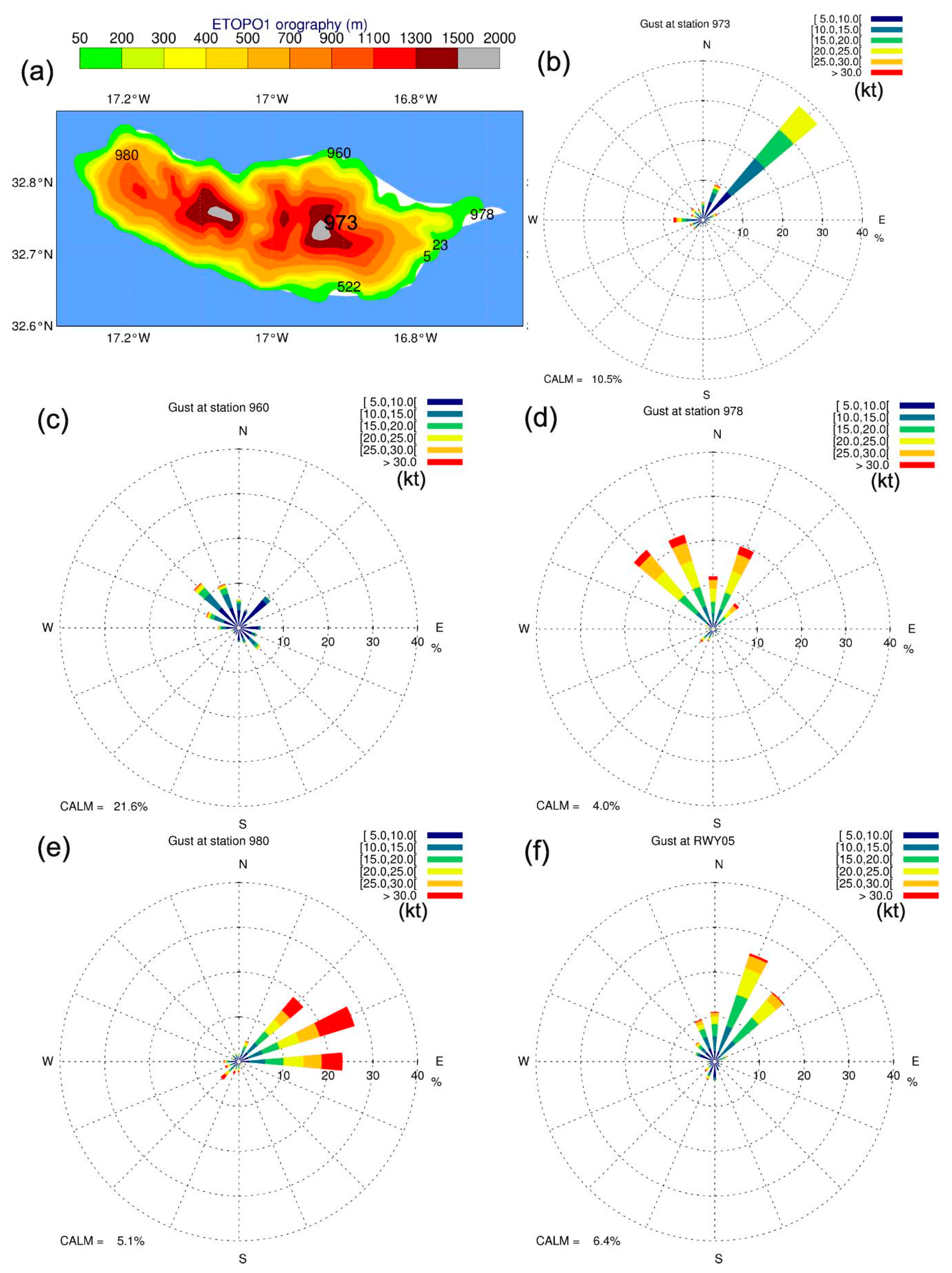

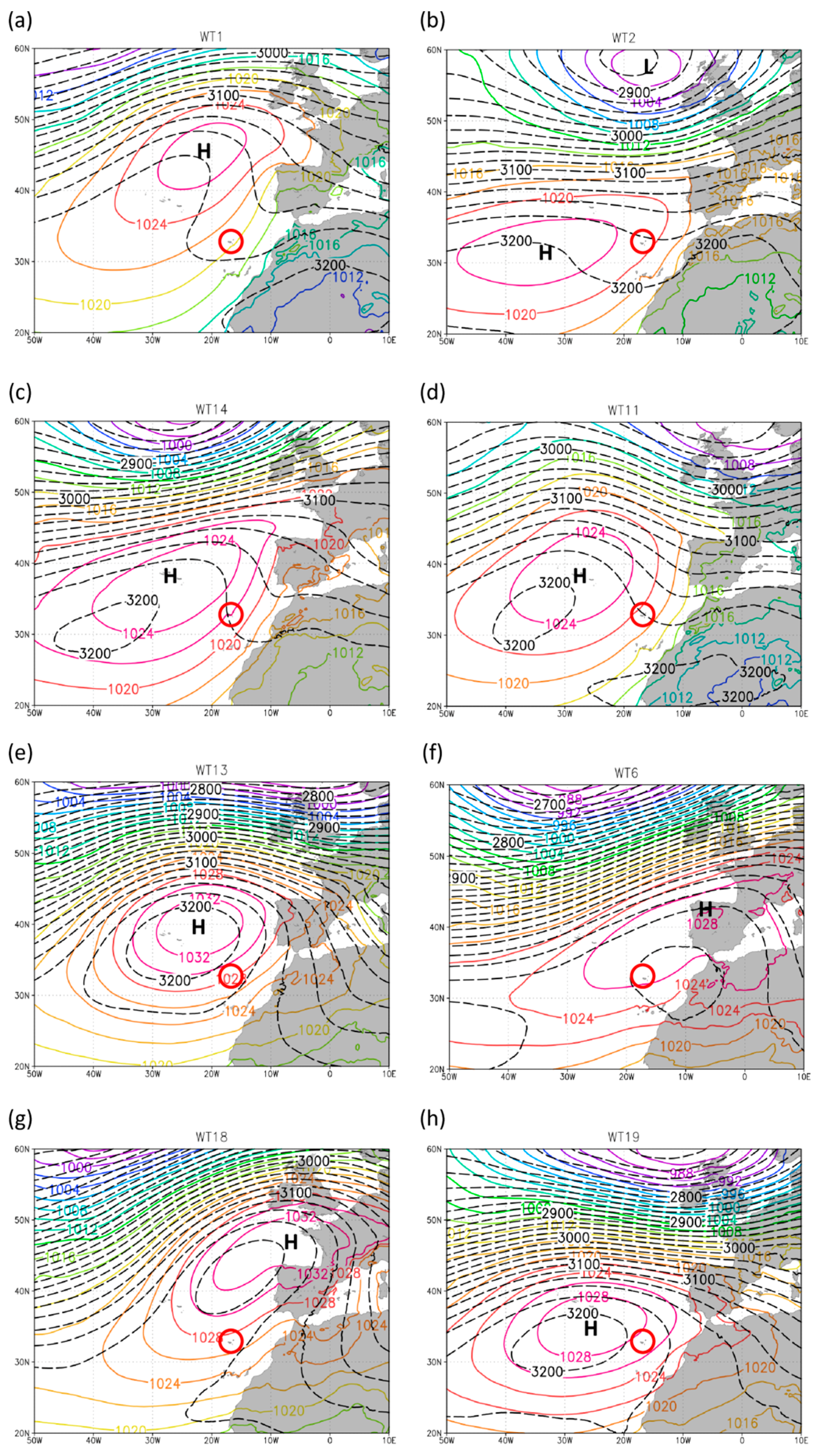
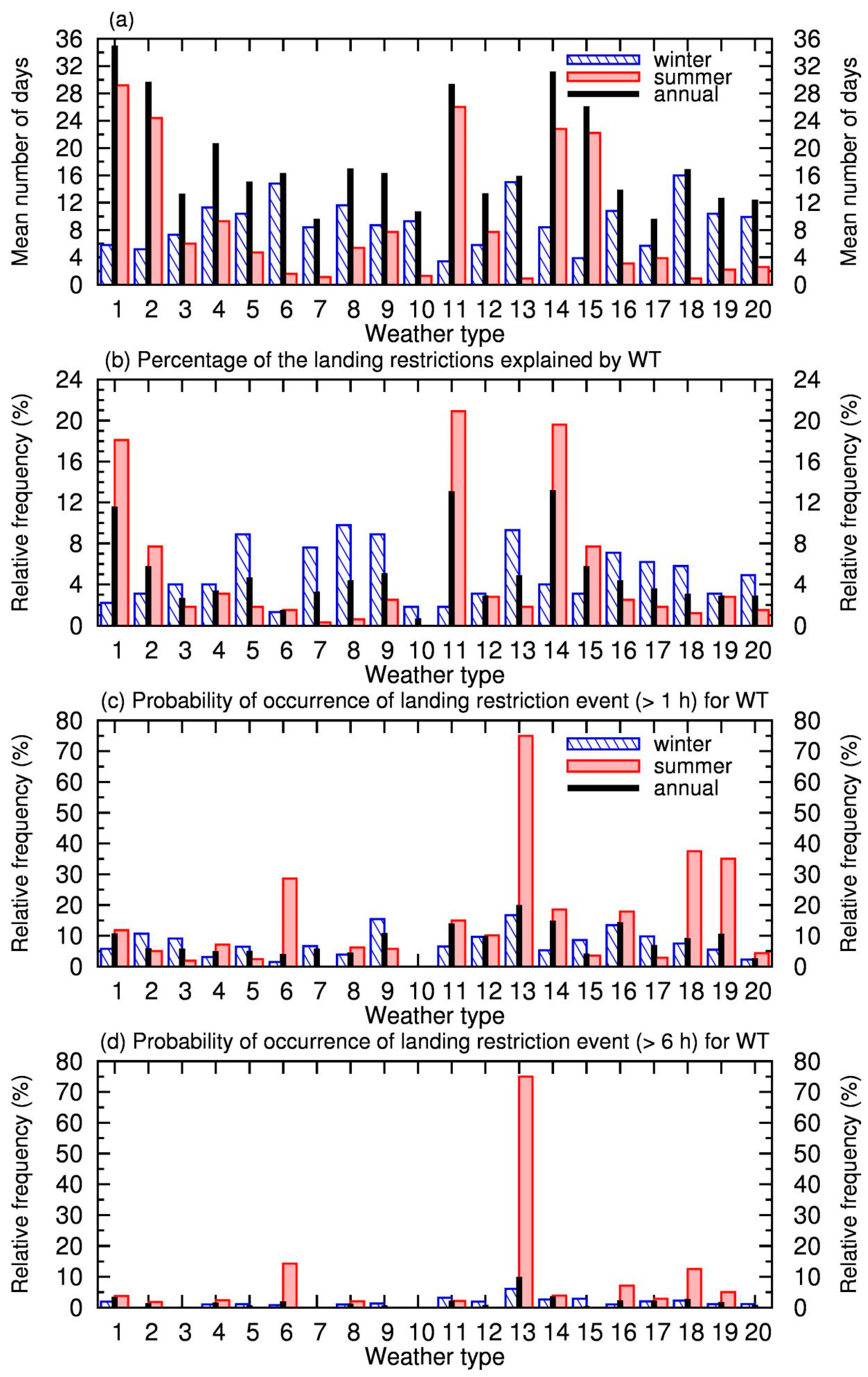
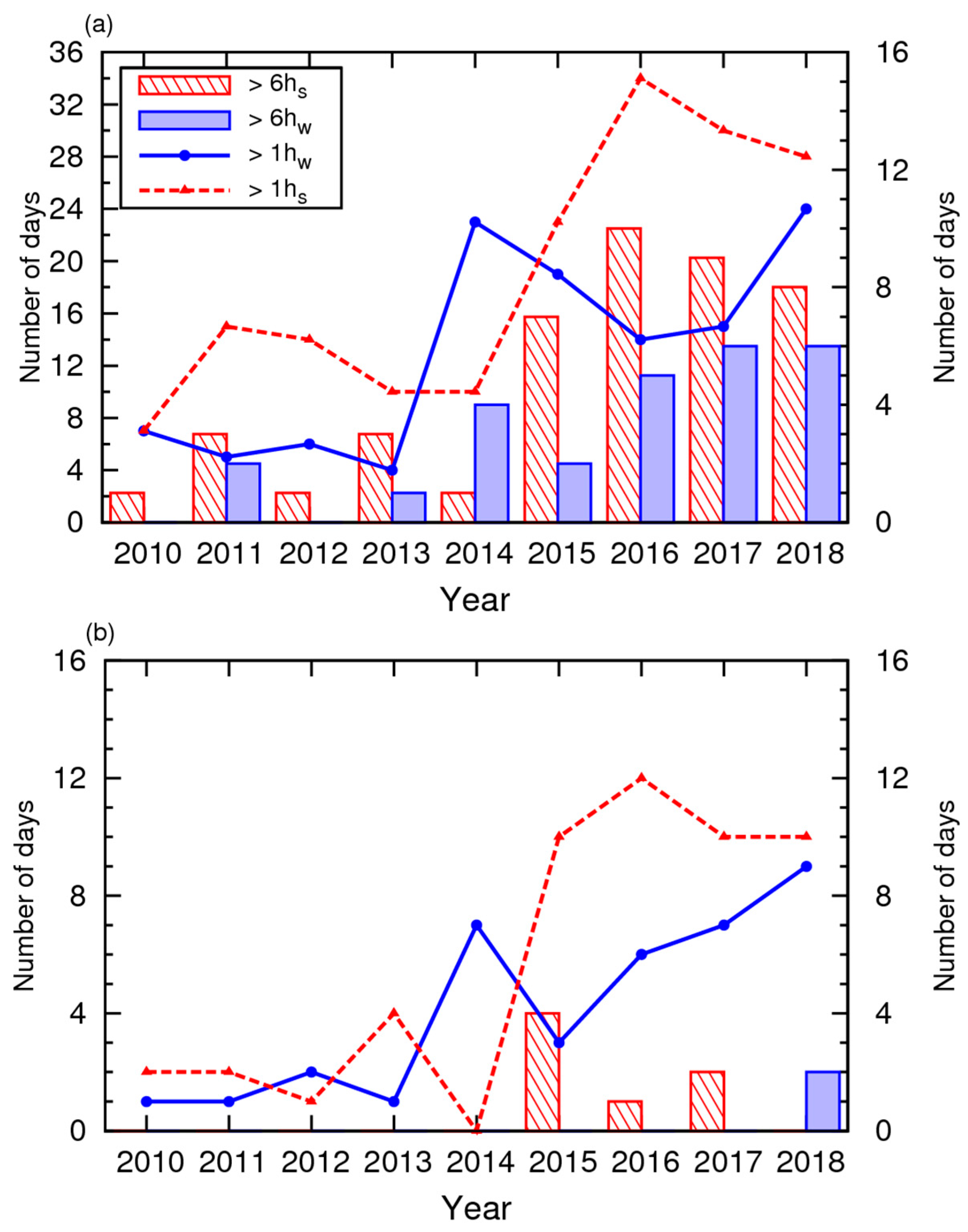



| Dynamical Features | Weather Types |
|---|---|
| Deep anticyclonic north-easterly flow | 6, 13, 16, 18, 19 |
| Anticyclonic westerly flow | 3, 7, 10 |
| Deep anticyclonic northerly flow | 9 |
| Shallow anticyclonic north-easterly flow | 1, 2, 4, 11, 14 |
| Shallow anticyclonic north-westerly/northerly flow | 12, 15 |
| Deep cyclonic westerly flow | 5, 8, 17 |
| Blocking high southern flank | 20 |
| Site | RMSE | MAE | om | pm | RMSEN | r |
|---|---|---|---|---|---|---|
| 05 | 2.5 (4.9) | 2.0 (3.9) | 5.5 (10.7) | 4.7 (9.1) | 0.46 | 0.62 |
| RS | 2.2 (4.3) | 1.7 (3.4) | 4.9 (9.5) | 4.1 (7.9) | 0.45 | 0.70 |
| MID | 2.4 (4.7) | 1.9 (3.8) | 5.8 (11.3) | 4.5 (8.7) | 0.41 | 0.75 |
| 23 | 2.7 (5.2) | 2.1 (4.2) | 6.2 (12.1) | 4.5 (8.7) | 0.43 | 0.73 |
| 960 | 1.3 (2.4) | 1.0 (1.9) | 2.1 (4.1) | 2.3 (4.5) | 0.59 | 0.54 |
| 973 | 2.8 (5.3) | 2.1 (4.0) | 5.1 (9.8) | 3.3 (6.4) | 0.54 | 0.78 |
| 978 | 1.6 (3.2) | 1.2 (2.4) | 6.3 (12.3) | 6.3 (12.1) | 0.26 | 0.78 |
| 986 | 1.7 (3.3) | 1.2 (2.3) | 1.9 (3.7) | 1.5 (3.0) | 0.89 | 0.16 |
| 522 | 0.9 (1.8) | 0.6 (1.2) | 1.3 (2.5) | 1.4 (2.8) | 0.71 | 0.62 |
| 524 | 1.3 (2.6) | 1.0 (1.9) | 5.4 (10.4) | 4.9 (9.6) | 0.25 | 0.74 |
| 980 | 5.0 (9.7) | 4.2 (8.2) | 8.5 (16.5) | 4.5 (8.8) | 0.59 | 0.84 |
| Site | RMSE | MAE | om | pm | RMSEN | r |
|---|---|---|---|---|---|---|
| 05 | 3.9 (7.6) | 2.9 (5.7) | 8.4 (16.4) | 10.2 (19.7) | 0.46 | 0.66 |
| RS | 3.2 (6.2) | 2.4 (4.7) | 7.8 (15.1) | 8.5 (16.5) | 0.41 | 0.76 |
| MID | 3.2 (6.2) | 2.4 (4.7) | 9.0 (17.5) | 10.2 (19.8) | 0.35 | 0.78 |
| 23 | 2.8 (5.5) | 2.2 (4.3) | 9.5 (18.5) | 10.2 (19.8) | 0.30 | 0.79 |
| 960 | 1.6 (3.1) | 1.2 (2.4) | 4.0 (7.8) | 4.1 (8.0) | 0.40 | 0.64 |
| 973 | 3.3 (6.3) | 2.6 (5.0) | 7.1 (13.8) | 8.1 (15.8) | 0.46 | 0.78 |
| 978 | 2.7 (5.3) | 2.3 (4.4) | 10.8 (21.0) | 8.9 (17.3) | 0.25 | 0.86 |
| 986 | 2.3 (4.5) | 1.8 (3.4) | 3.2 (6.2) | 3.5 (6.9) | 0.72 | 0.24 |
| 522 | 1.7 (3.4) | 1.2 (2.3) | 2.7 (5.2) | 3.3 (6.3) | 0.66 | 0.65 |
| 524 | 1.6 (3.1) | 1.2 (2.4) | 8.1 (15.7) | 8.4 (16.3) | 0.20 | 0.81 |
| 980 | 3.3 (6.5) | 2.7 (5.3) | 11.1 (21.5) | 9.9 (19.3) | 0.30 | 0.82 |
| Site | RMSE | MAE |
|---|---|---|
| 05 | 33.2 | 29.5 |
| RS | 35.8 | 26.7 |
| MID | 26.7 | 23.9 |
| 23 | 16.6 | 12.8 |
| 960 | 38.8 | 33.4 |
| 973 | 26.9 | 21.4 |
| 978 | 19.9 | 14.1 |
| 986 | 77.1 | 61.3 |
| 522 | 49.6 | 29.0 |
| 524 | 16.1 | 13.4 |
| 980 | 20.2 | 16.1 |
Publisher’s Note: MDPI stays neutral with regard to jurisdictional claims in published maps and institutional affiliations. |
© 2020 by the authors. Licensee MDPI, Basel, Switzerland. This article is an open access article distributed under the terms and conditions of the Creative Commons Attribution (CC BY) license (http://creativecommons.org/licenses/by/4.0/).
Share and Cite
Belo-Pereira, M.; Santos, J.A. Air-Traffic Restrictions at the Madeira International Airport Due to Adverse Winds: Links to Synoptic-Scale Patterns and Orographic Effects. Atmosphere 2020, 11, 1257. https://doi.org/10.3390/atmos11111257
Belo-Pereira M, Santos JA. Air-Traffic Restrictions at the Madeira International Airport Due to Adverse Winds: Links to Synoptic-Scale Patterns and Orographic Effects. Atmosphere. 2020; 11(11):1257. https://doi.org/10.3390/atmos11111257
Chicago/Turabian StyleBelo-Pereira, Margarida, and João A. Santos. 2020. "Air-Traffic Restrictions at the Madeira International Airport Due to Adverse Winds: Links to Synoptic-Scale Patterns and Orographic Effects" Atmosphere 11, no. 11: 1257. https://doi.org/10.3390/atmos11111257


