An Analysis of Fog in the Mainland Portuguese International Airports


Abstract
:
1. Introduction
2. Observational Data and Methods
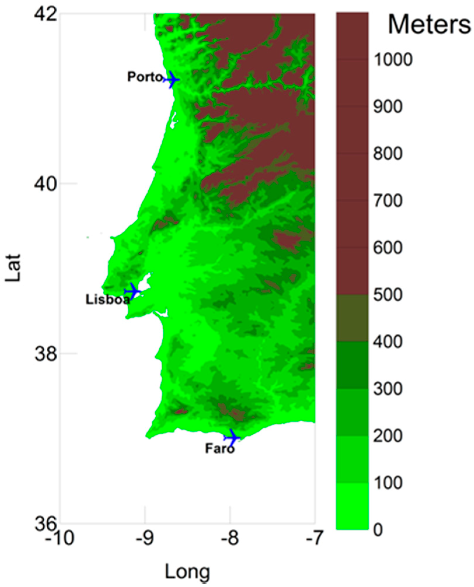
2.1. Observational Data
2.2. Large Scale Circulation Classification
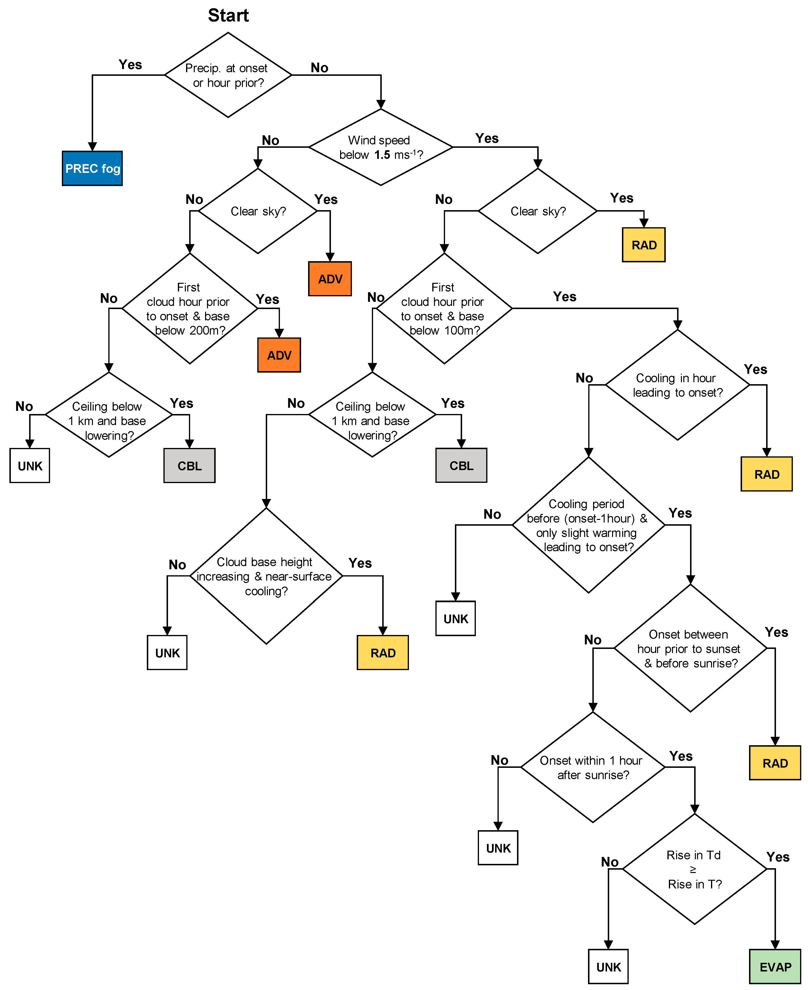
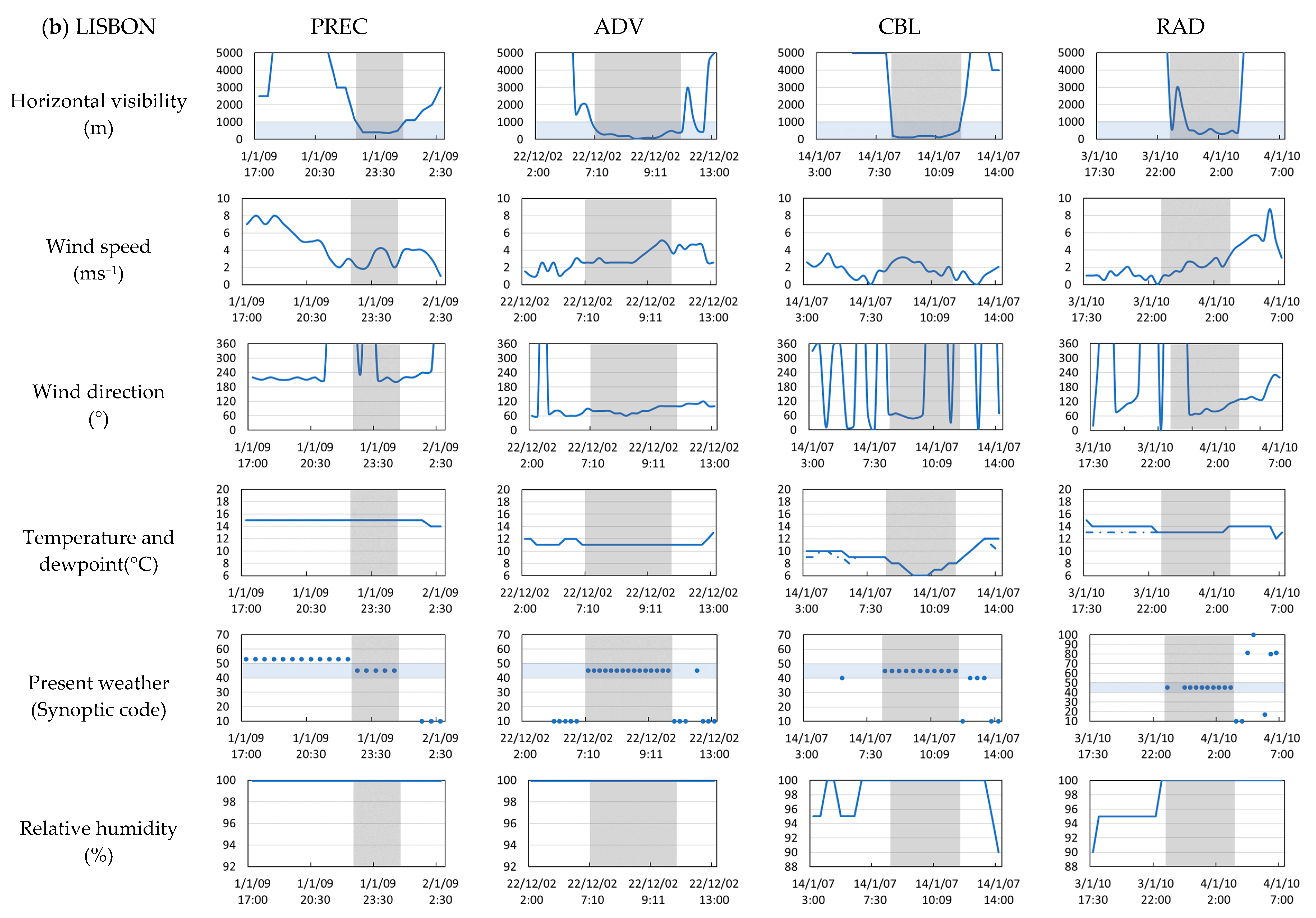
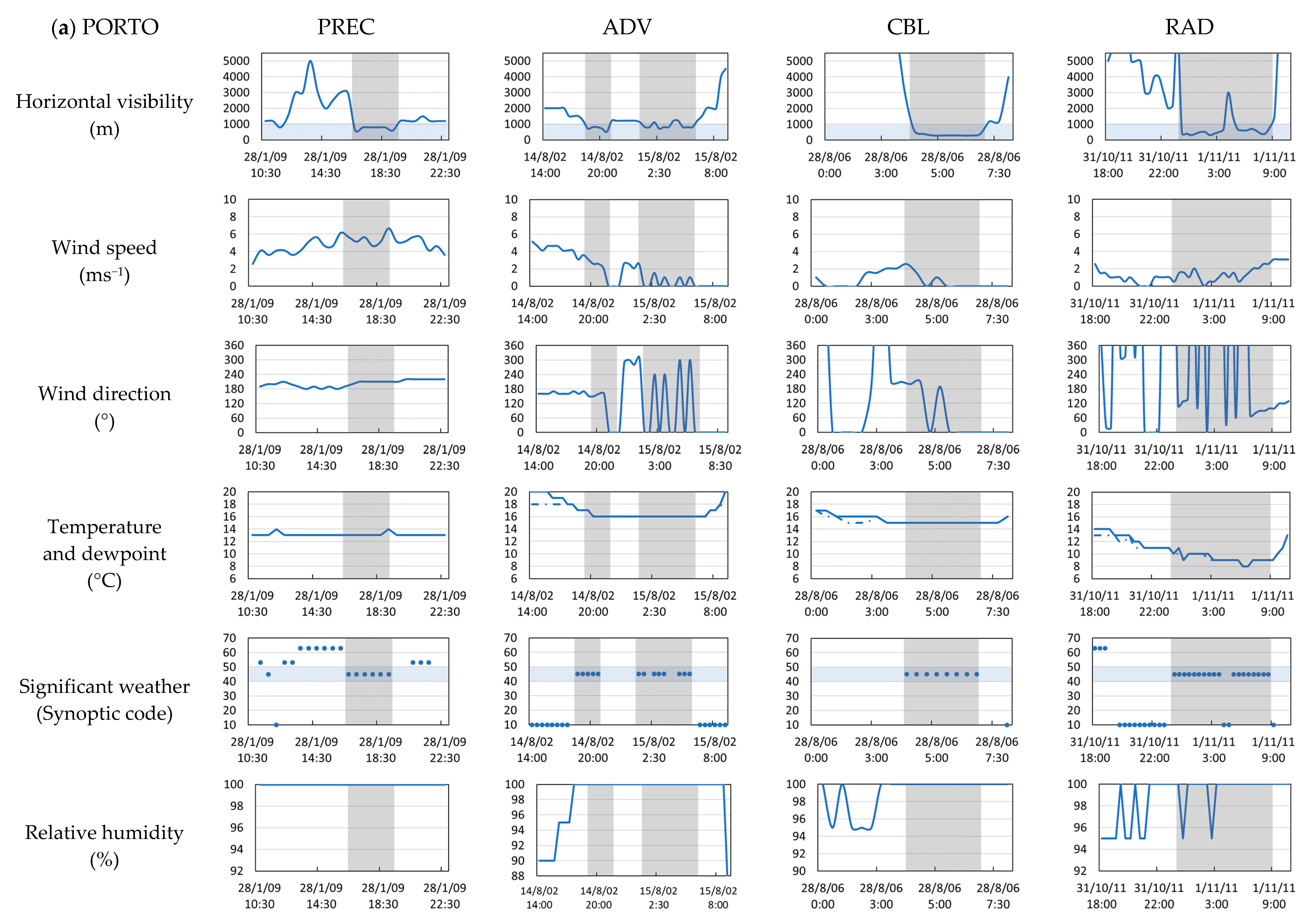
2.3. Fog Types Classification
3. Results
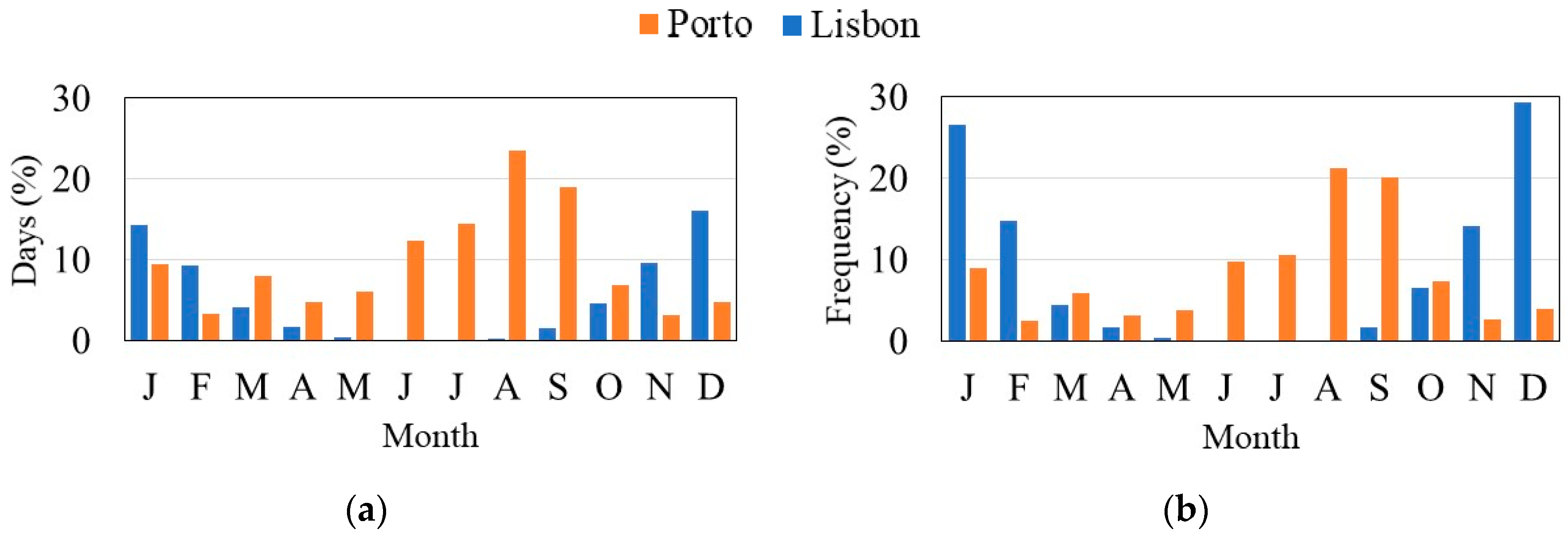
3.1. Annual and Monthly Fog Events
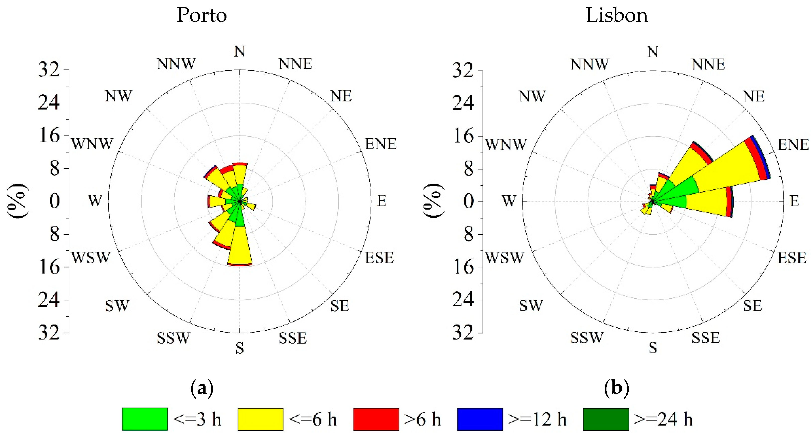
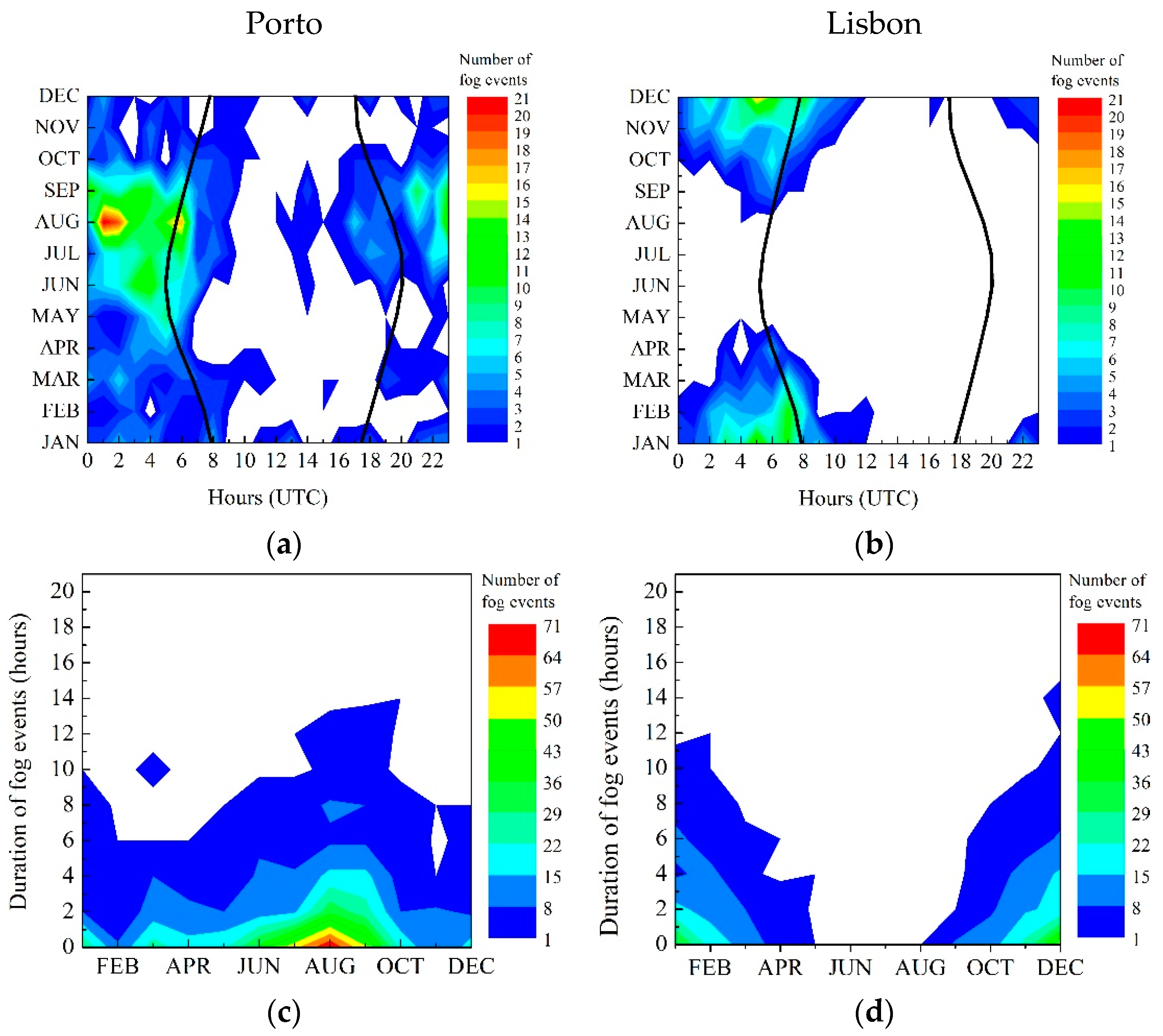
3.2. Diurnal Cycle and Duration
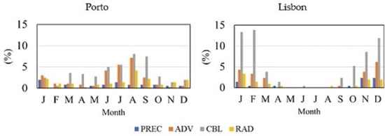
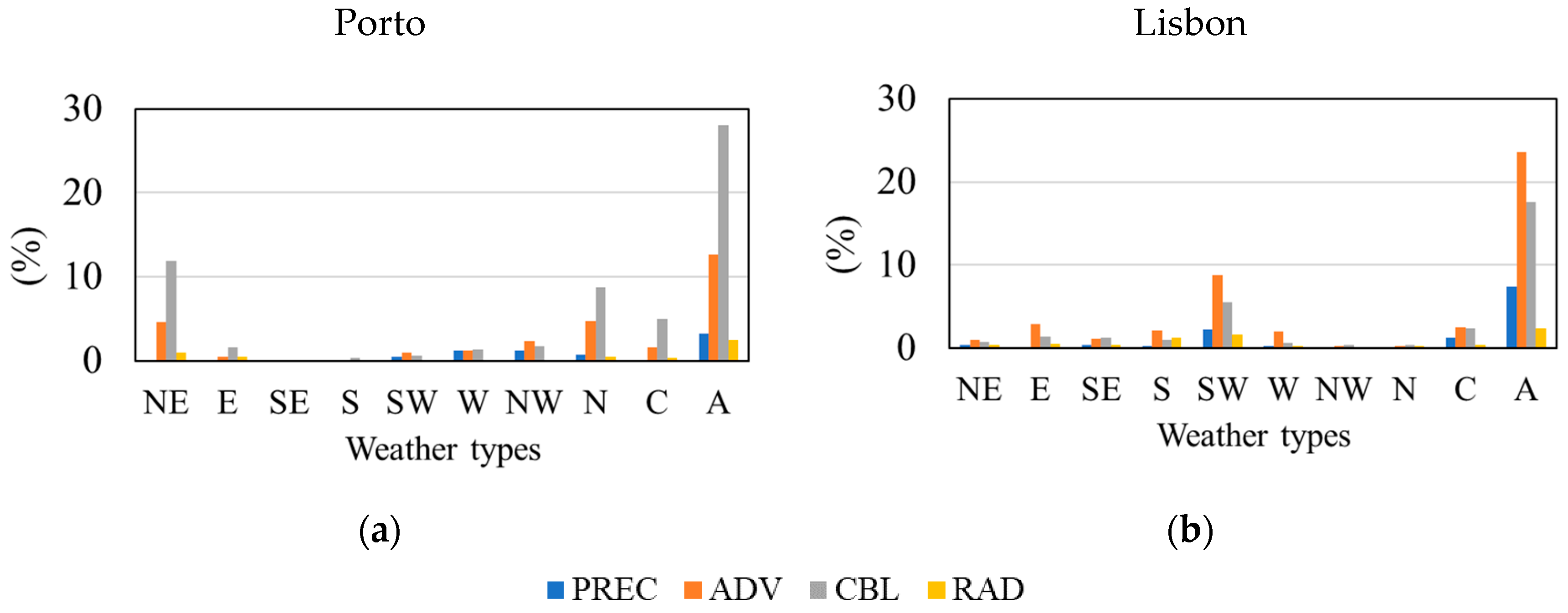
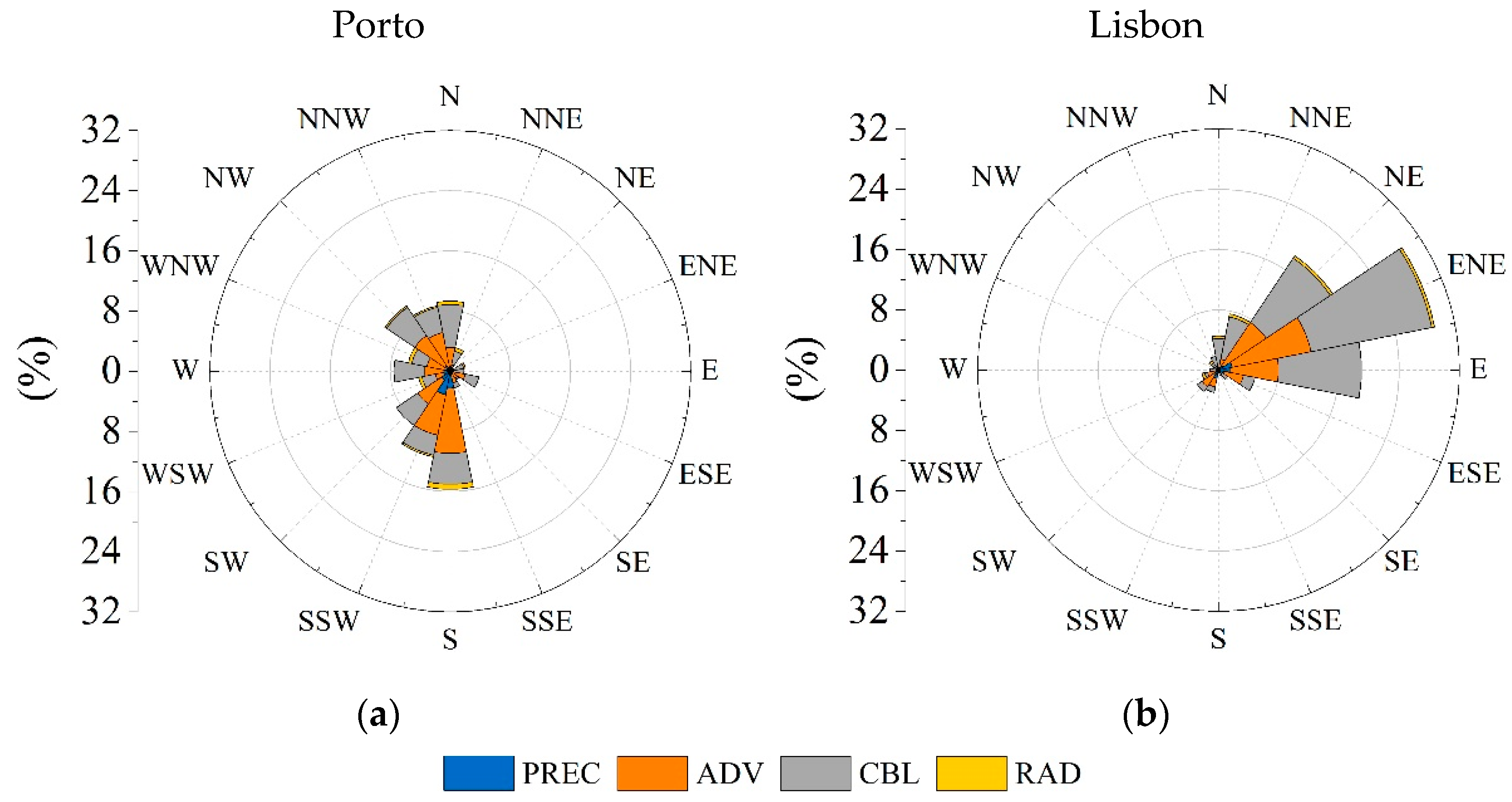
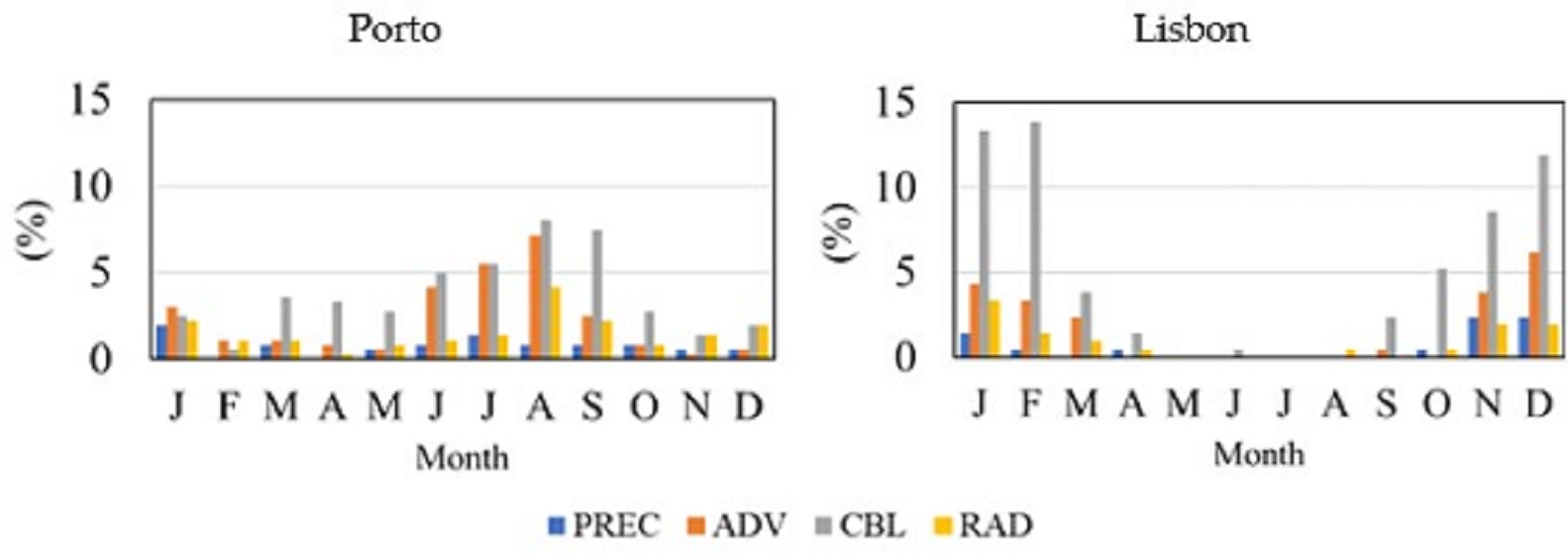
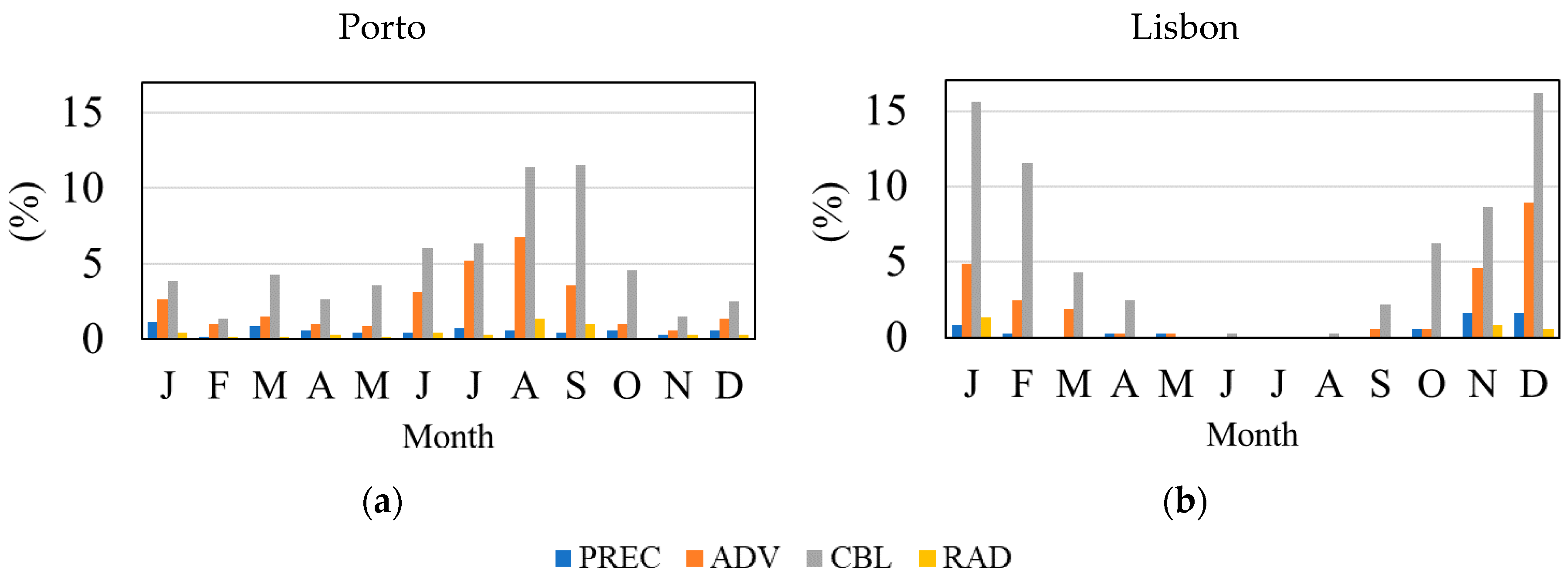
3.3. Fog Types Classification
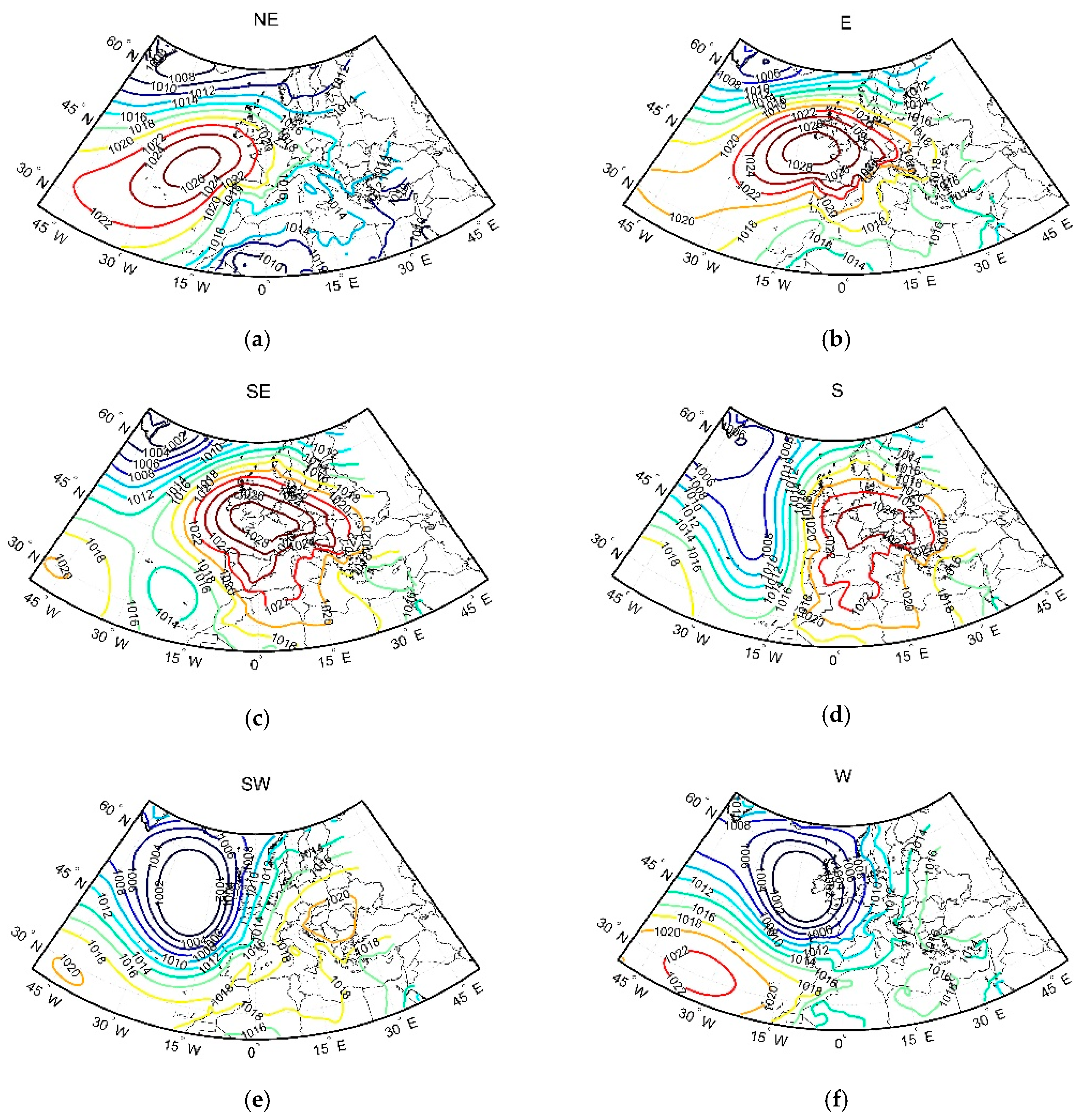
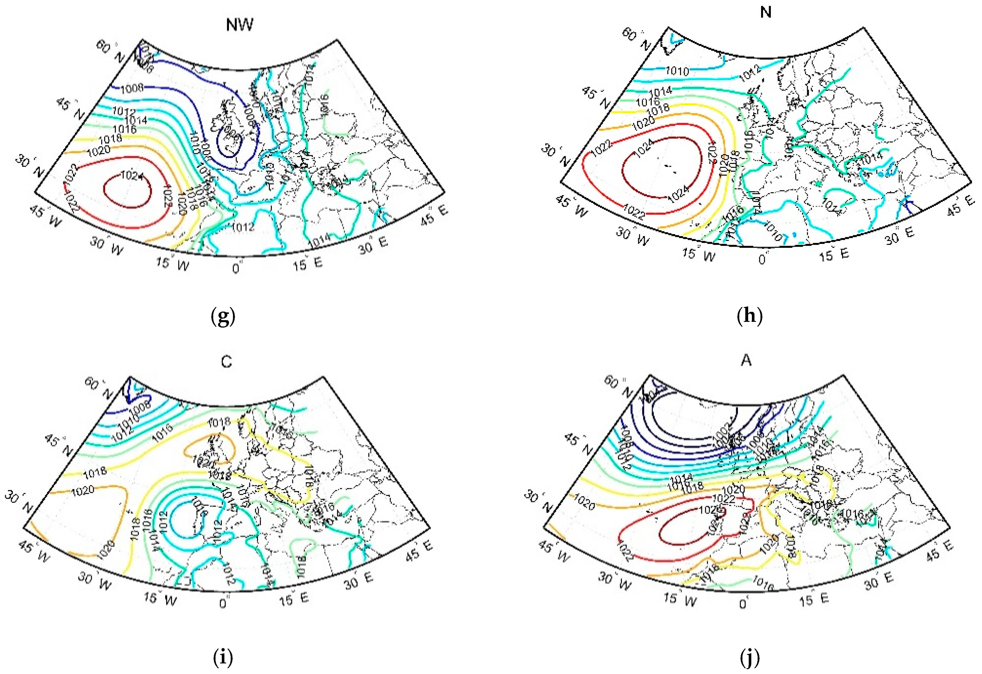
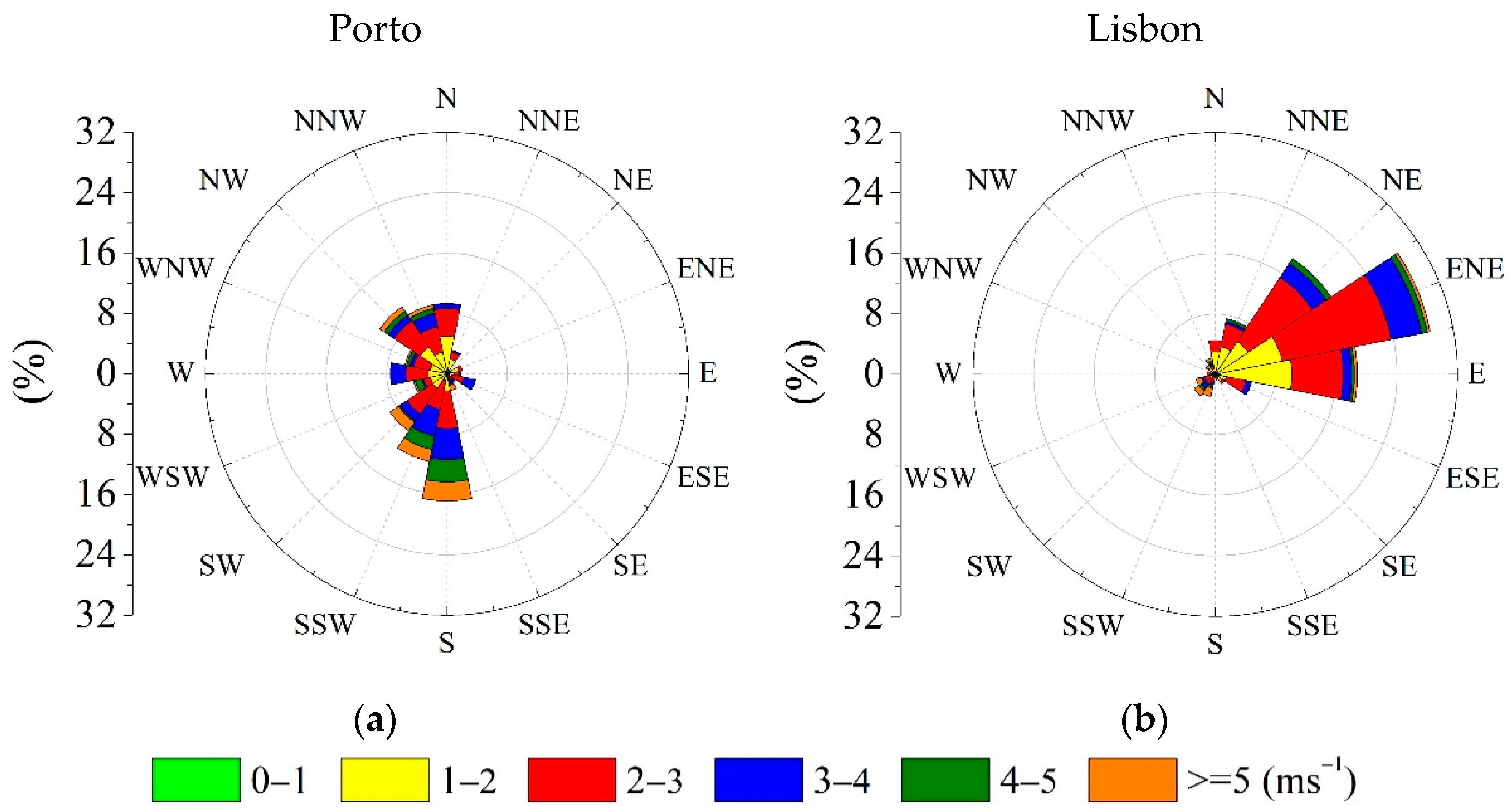
3.4. Large to Local Scale Circulation Analysis
4. Conclusions
Author Contributions
Funding
Acknowledgments
Conflicts of Interest
References
- Tardif, R.; Rasmussen, R.M. Event-based climatology and typology of fog in the New York City region. J. Appl. Meteorol. Climatol. 2007, 46, 1141–1168. [Google Scholar] [CrossRef] [Green Version]
- World Meteorological Oranization. WMO Guide to Meteorological Instruments and Methods of Observation; WMO: Geneva, Switzerland, 2017; Available online: www.wmo.int (accessed on 3 March 2020).
- Willett, H.C. Fog and Haze, Their Causes, Distribution, and Forecasting. Mon. Weather Rev. 1928, 56, 435–468. [Google Scholar] [CrossRef]
- Byers, H.R. General Meteorology, 3rd ed.; McGraw-Hill: New York, NY, USA, 1959; 481p. [Google Scholar]
- Houssos, E.E.; Lolis, C.J.; Gkikas, A.; Hatzianastassiou, N.; Bartzokas, A. On the atmospheric circulation characteristics associated with fog in Ioannina, north-western Greece. Int. J. Climatol. 2012, 32, 1847–1862. [Google Scholar] [CrossRef]
- Stolaki, S.N.; Kazadzis, S.A.; Foris, D.V.; Karacostas, T.S. Fog characteristics at the airport of Thessaloniki, Greece. Nat. Hazards Earth Syst. Sci. 2009, 9, 1541–1549. [Google Scholar] [CrossRef] [Green Version]
- Teixeira, J.; Miranda, P.M.A. Fog prediction at Lisbon airport using a one-dimensional boundary layer model. Meteorol. Appl. 2001, 8, 497–505. [Google Scholar] [CrossRef]
- Belo-Pereira, M.; Santos, J.A. A persistent wintertime fog episode at Lisbon airport (Portugal): Performance of ECMWF and AROME models. Meteorol. Appl. 2016, 233, 353–370. [Google Scholar] [CrossRef] [Green Version]
- Tardif, R.; Rasmussen, R.M. Process-oriented analysis of environmental conditions associated with precipitation fog events in the New York City region. J. Appl. Meteorol. Climatol. 2008, 47, 1681–1703. [Google Scholar] [CrossRef] [Green Version]
- Bergot, T. Quality assessment of the cobel-isba numerical forecast system of fog and low clouds. Pure Appl. Geophys. 2007, 164, 1265–1282. [Google Scholar] [CrossRef]
- Haeffelin, M.; Dupont, J.; Boyouk, N.; Baumgardner, D.; Gomes, L.; Roberts, G.; Elias, T. A Comparative Study of Radiation Fog and Quasi-Fog Formation Processes During the ParisFog Field Experiment 2007. Pure Appl. Geophys. 2013, 170, 2283–2303. [Google Scholar] [CrossRef]
- Terradellas, E.; Cano, D. Implementation of single-column model for fog and low cloud forecasting at central Spanish airports. Pure Appl. Geophys. 2007, 164, 1327–1345. [Google Scholar] [CrossRef]
- van Oldenborgh, G.J.; Yiou, P.; Vautard, R. On the roles of circulation and aerosols in the decline of mist and dense fog in Europe over the last 30 years. Atmos. Chem. Phys. 2010, 10, 4597–4609. [Google Scholar] [CrossRef] [Green Version]
- Policarpo, C.; Salgado, R.; Costa, M.J. Numerical simulations of fog events in southern Portugal. Adv. Meteorol. 2017. [Google Scholar] [CrossRef]
- Egli, S.; Thies, B.; Bendix, J. A spatially explicit and temporally highly resolved analysis of variations in fog occurrence over Europe. Q. J. R. Meteorol. Soc. 2019, 145, 1721–1740. [Google Scholar] [CrossRef]
- Vautard, R.; Yiou, P.; Van Oldenborgh, G.J. Decline of fog, mist and haze in Europe over the past 30 years. Nat. Geosci. 2009, 2, 115–119. [Google Scholar] [CrossRef]
- Akimoto, Y.; Kusaka, H. A climatological study of fog in Japan based on event data. Atmos. Res. 2015, 151, 200–211. [Google Scholar] [CrossRef]
- Belorid, M.; Lee, C.B.; Kim, J.C.; Cheon, T.H. Distribution and long-term trends in various fog types over South Korea. Theor. Appl. Climatol. 2015, 22, 699–710. [Google Scholar] [CrossRef]
- Gu, Y.; Kusaka, H.; Tan, J. Impacts of urban expansion on fog types in Shanghai, China: Numerical experiments by WRF model. Atmos. Res. 2019, 220, 57–74. [Google Scholar] [CrossRef]
- Trigo, R.M.; DaCamara, C.C. Circulation weather types y their influence on the precipitation regime in Portugal. Int. J. Climatol. 2000, 20, 1559–1581. [Google Scholar] [CrossRef]
- Ramos, A.M.; Ramos, R.; Sousa, P.; Trigo, R.M.; Janeira, M.; Prior, V. Cloud to ground lightning activity over Portugal and its association with circulation weather types. Atmos. Res. 2011, 101, 84–101. [Google Scholar] [CrossRef]
- WMO. Manual on Codes (WMO-No.306); Volume I, Anex 2, Part-A; WMO: Geneva, Switzerland, 2019. [Google Scholar]
- WMO. Meteorological service for international air navigation. In Technical Regulations (WMO-No. 49); WMO: Geneva, Switzerland, 2008; Volume II. [Google Scholar]
- Huth, R. A circulation classification scheme applicable in GCM studies. Theor. Appl. Climatol. 2000, 67, 1–18. [Google Scholar] [CrossRef]
- Ramos, A.M.; Pires, A.C.; Sousa, P.M.; Trigo, R.M. The use of circulation weather types to predict upwelling activity along the western Iberian Peninsula coast. Cont. Shelf Res. 2013, 69, 38–51. [Google Scholar] [CrossRef]
- Jones, P.D.; Osborn, T.J.; Harpham, C.; Briffa, K.R. The development of Lamb weather types: From subjective analysis of weather charts to objective approaches using reanalyses. Weather 2014, 69, 128–132. [Google Scholar] [CrossRef] [Green Version]
- Mellado-Cano, J.; Barriopedro, D.; García-Herrera, R.; Trigo, R.M.; Álvarez-Castro, M.C. Euro-Atlantic Atmospheric Circulation during the Late Maunder Minimum. J. Clim. 2018, 31, 3849–3863. [Google Scholar] [CrossRef]
- Mellado-Cano, J.; Barriopedro, D.; García-Herrera, R.; Trigo, R.M. New observational insights into the atmospheric circulation over the Euro-Atlantic sector since 1685. Clim. Dyn. 2020, 54, 823–841. [Google Scholar] [CrossRef] [Green Version]
- Lorenzo, M.N.; Ramos, A.M.; Taboada, J.J.; Gimeno, L. Changes in present and future circulation types frequency in northwest Iberian Peninsula. PLoS ONE 2011, 6, e16201. [Google Scholar] [CrossRef] [PubMed]
- Lamb, H.H. British Isles weather types and a register of the daily sequence of circulation patterns. Geophys. Mem. 1972, 116, 85. [Google Scholar]
- Jenkinson, A.F.; Collison, F.P. An Initial Climatology of Gales over the North Sea. In Synoptic Climatology Branch Memorandum; Meteorological Office: Bracknell, UK, 1977; p. 62. [Google Scholar]
- Hess, P.; Brezowsky, H. Katalog der Grosswetterlagen Europas (1881–1976). In Berichte Deutsche Wetterdienstes; Nr 113 Bd. 15; Selbstverlag des Deutschen Wetterdienstes: Offenbach am Main, Germany, 1977. [Google Scholar]
- Dee, D.P.; Uppala, S.M.; Simmons, A.J.; Berrisford, P.; Poli, P.; Kobayashi, S.; Andrae, U.; Balmaseda, M.A.; Balsamo, G.; Bauer, P.; et al. The ERA-Interim reanalysis: Configuration and performance of the data assimilation system. Q. J. R. Meteorol. Soc. 2011, 137, 553–597. [Google Scholar] [CrossRef]
- van Schalkwyk, L.; Dyson, L.L. Climatological characteristics of fog at cape town international airport. Weather Forecast. 2013, 28, 631–646. [Google Scholar] [CrossRef] [Green Version]
- Izett, J.G.; van Wiel, B.J.H.; Baas, P.; van Hooft, J.A.; Schulte, R.B. Dutch fog: On the observed spatio-temporal variability of fog in the Netherlands. Q. J. R. Meteorol. Soc. 2019, 145, 2817–2834. [Google Scholar] [CrossRef]


| Fog Types | Precondition | Primary Mechanisms | References |
|---|---|---|---|
| Precipitation (PREC) | Precipitation at onset or hour prior. | Evaporation of precipitation from surface. | Baars et al. (2001) Tardif and Rasmussen (2007) |
| Advection (ADV) | Wind speed above 1.5 m/s, low clouds below 200 m in hour prior to onset or clear sky. | Advection of temperature or moisture and condensation over a cold surface. | Tardif and Rasmussen (2007) |
| Cloud-base lowering (CBL) | Low clouds in hour prior to onset with gradual decreasing of base height. | Radiative cooling of the stratus clouds top leading to cooled subsidence followed by water vapour condensation due to sub-layer turbulent mixing. | Tardif and Rasmussen (2007) Gultepe et al. (2007) Dupont et al. (2012) |
| Radiation (RAD) | Wind speed bellow 1.5 m/s, clear sky or low clouds in hour prior to onset and cooling in hour leading to onset or onset in the cooler period, between hour prior to sunset and before sunrise. | Surface radiative cooling due to upward heat flux and turbulent mixing. | Dyunkerke (1998) Tardif and Rasmussen (2007) Haeffelin et al. (2013) |
| Evaporation (EVP) | Clear sky or onset one hour after sunrise followed by the rise of dewpoint greater than rise of temperature | Increasing rate in surface evaporation due to early morning warming after sunrise followed by condensation into cold air and turbulent mixing. | Arya (2001) Tardif and Rasmussen (2007) |
| Porto | Lisbon | Faro | |
|---|---|---|---|
| Daily occurrences | 601 (9.68%) | 320 (5.15%) | 60 (0.97%) |
| Events | PREC | ADV | CBL | RAD | EVP | UNK | |
|---|---|---|---|---|---|---|---|
| Porto % | 699 100 | 47 6.7 | 194 27.8 | 403 57.7 | 33 4.7 | 0 0.0 | 22 3.5 |
| Lisbon % | 375 100 | 20 5.3 | 90 24.0 | 251 66.9 | 10 2.7 | 0 0.0 | 4 1.1 |
| Porto | ||||||||||||||
| Type | Events | Onset-Sunrise Hours Before(−) and After(+) | Dissipatiuon-Sunrise Hours Before(−) and After(+) | Duration (hours) | Visibility (meters) | Min. Visibility (meters) | ||||||||
| Average | Median | Average | Median | Average | Median | Average | Median | 25% | 50% | 75% | Average | Median | ||
| PREC | 47 | −0.6 | +1.0 | +1.1 | +2.0 | 2.2 | 0.7 | 573.2 | 600 | 400 | 600 | 800 | 554.3 | 500 |
| ADV | 194 | −2.2 | −2.0 | +0.3 | +1.0 | 2.1 | 1.0 | 586.5 | 600 | 400 | 600 | 800 | 546.6 | 550 |
| CBL | 403 | −2.8 | −2.0 | +0.1 | +1.0 | 2.5 | 1.5 | 504.3 | 500 | 300 | 500 | 700 | 217.8 | 200 |
| RAD | 33 | −3.1 | −2.0 | +0.6 | +1.0 | 3.6 | 2.5 | 530.7 | 500 | 325 | 500 | 700 | 312.9 | 250 |
| EVP | 0 | - | - | - | - | - | - | - | - | - | - | - | - | - |
| Lisbon | ||||||||||||||
| Type | Events | Onset-Sunrise Hours Before(−) and After(+) | Dissipatiuon-Sunrise Hours Before(−) and After(+) | Duration (hours) | Visibility (meters) | Min. Visibility (meters) | ||||||||
| Average | Median | Average | Median | Average | Median | Average | Median | 25% | 50% | 75% | Average | Median | ||
| PREC | 20 | −2.4 | −0.5 | −1.4 | +1.0 | 0.8 | 0.3 | 616.4 | 600 | 500 | 600 | 800 | 557.5 | 500 |
| ADV | 90 | −0.8 | 0.0 | +1.7 | +2.0 | 2.7 | 1.7 | 388.5 | 325 | 200 | 325 | 500 | 297.7 | 200 |
| CBL | 251 | −1.9 | −2.0 | +1.0 | +1.0 | 3.5 | 2.1 | 328.0 | 300 | 150 | 300 | 500 | 232.5 | 150 |
| RAD | 10 | −5.0 | −4.0 | +0.9 | +2.0 | 3.8 | 4.0 | 291.2 | 200 | 150 | 300 | 600 | 288.9 | 150 |
| EVP | 0 | - | - | - | - | - | - | - | - | - | - | - | - | - |
Publisher’s Note: MDPI stays neutral with regard to jurisdictional claims in published maps and institutional affiliations. |
© 2020 by the authors. Licensee MDPI, Basel, Switzerland. This article is an open access article distributed under the terms and conditions of the Creative Commons Attribution (CC BY) license (http://creativecommons.org/licenses/by/4.0/).
Share and Cite
Guerreiro, P.M.P.; Soares, P.M.M.; Cardoso, R.M.; Ramos, A.M. An Analysis of Fog in the Mainland Portuguese International Airports. Atmosphere 2020, 11, 1239. https://doi.org/10.3390/atmos11111239
Guerreiro PMP, Soares PMM, Cardoso RM, Ramos AM. An Analysis of Fog in the Mainland Portuguese International Airports. Atmosphere. 2020; 11(11):1239. https://doi.org/10.3390/atmos11111239
Chicago/Turabian StyleGuerreiro, Pedro M. P., Pedro M. M. Soares, Rita M. Cardoso, and Alexandre M. Ramos. 2020. "An Analysis of Fog in the Mainland Portuguese International Airports" Atmosphere 11, no. 11: 1239. https://doi.org/10.3390/atmos11111239
APA StyleGuerreiro, P. M. P., Soares, P. M. M., Cardoso, R. M., & Ramos, A. M. (2020). An Analysis of Fog in the Mainland Portuguese International Airports. Atmosphere, 11(11), 1239. https://doi.org/10.3390/atmos11111239