Urban Rainfall Anomaly under Intensive Development, 1949–2018, Case of Tel-Aviv, Israel


Abstract
:1. Introduction
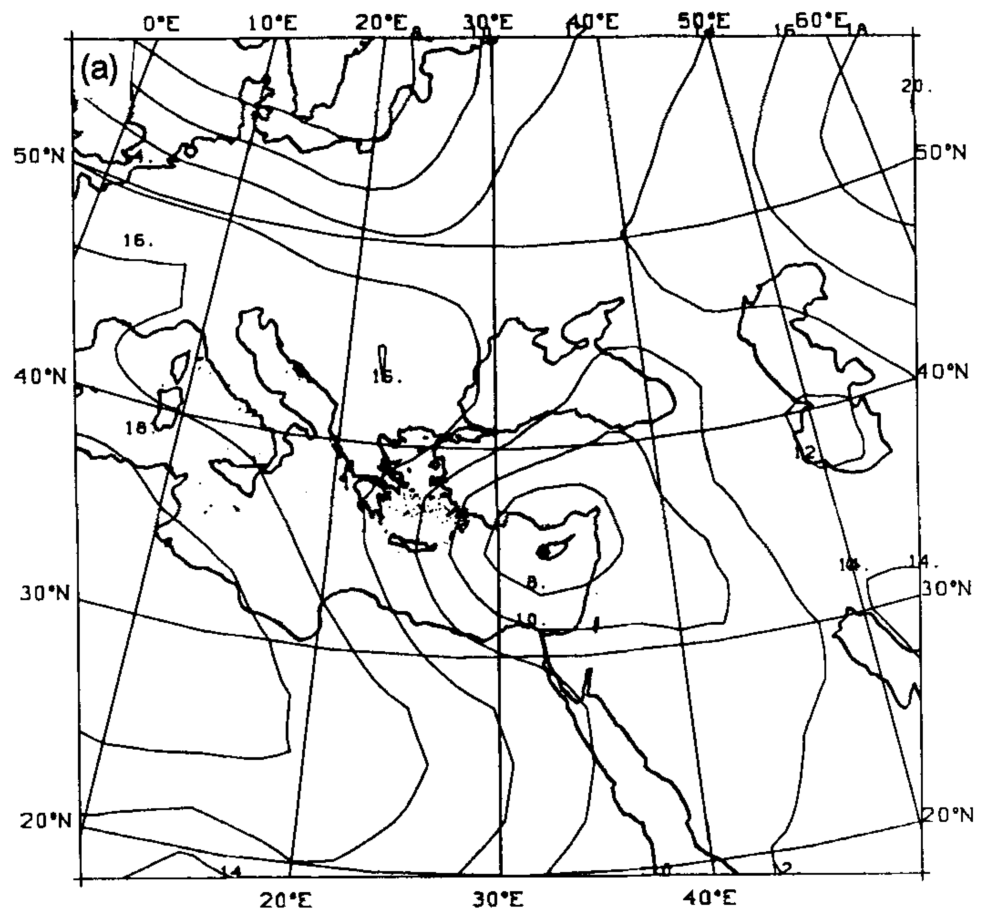
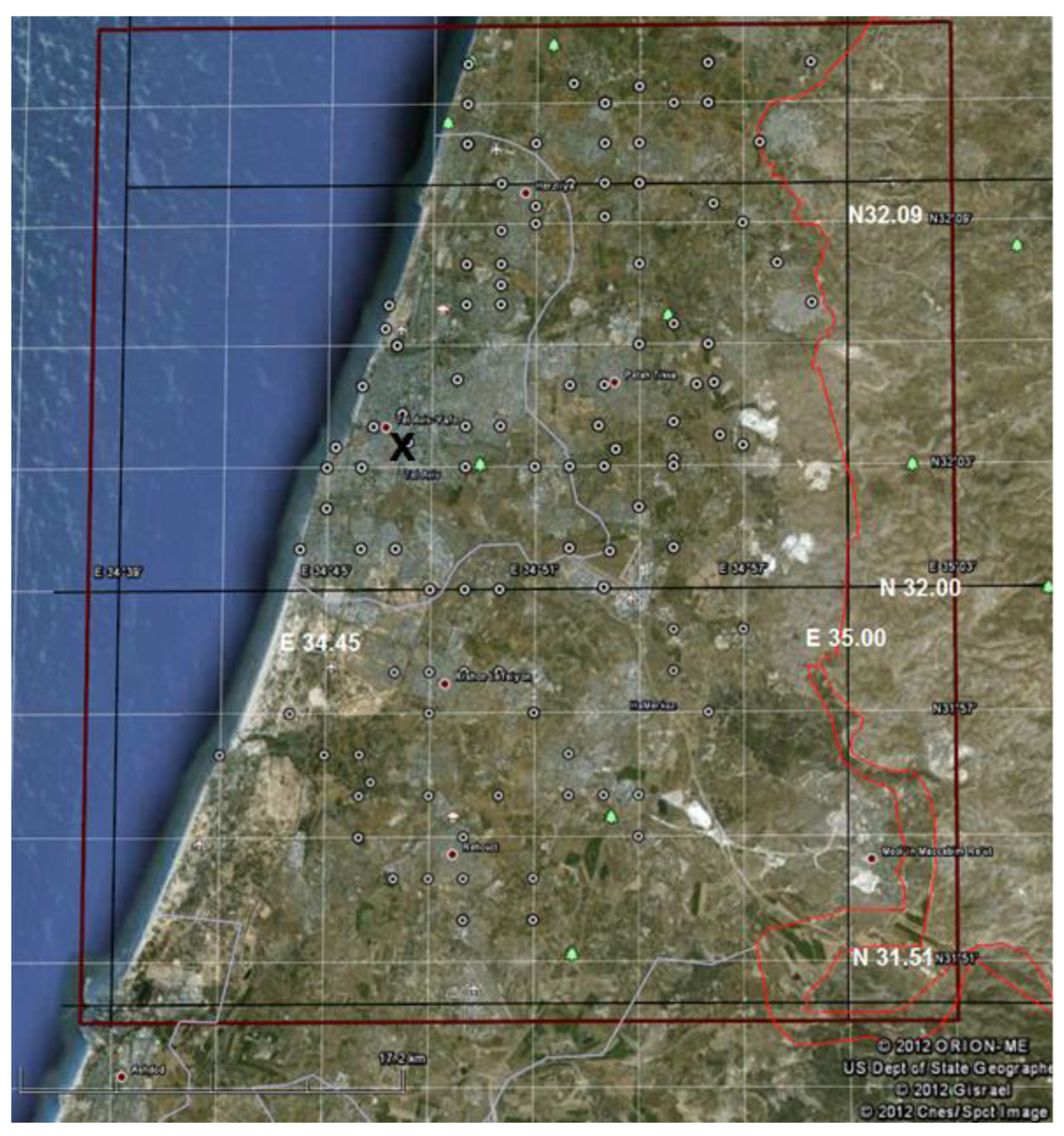
2. The Study Area
3. Data and Methods
3.1. The Rainfall Data
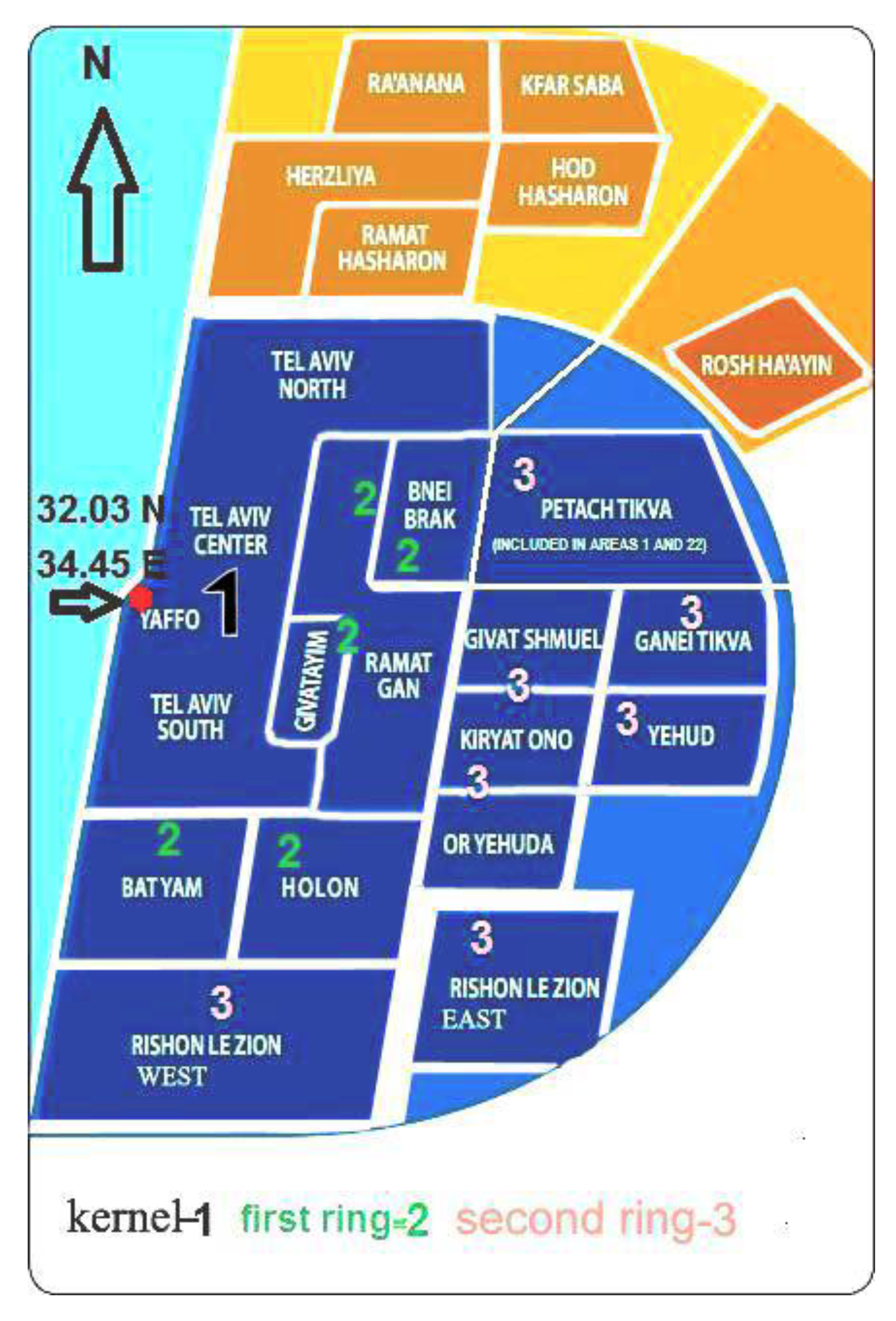
3.2. The Urban Area
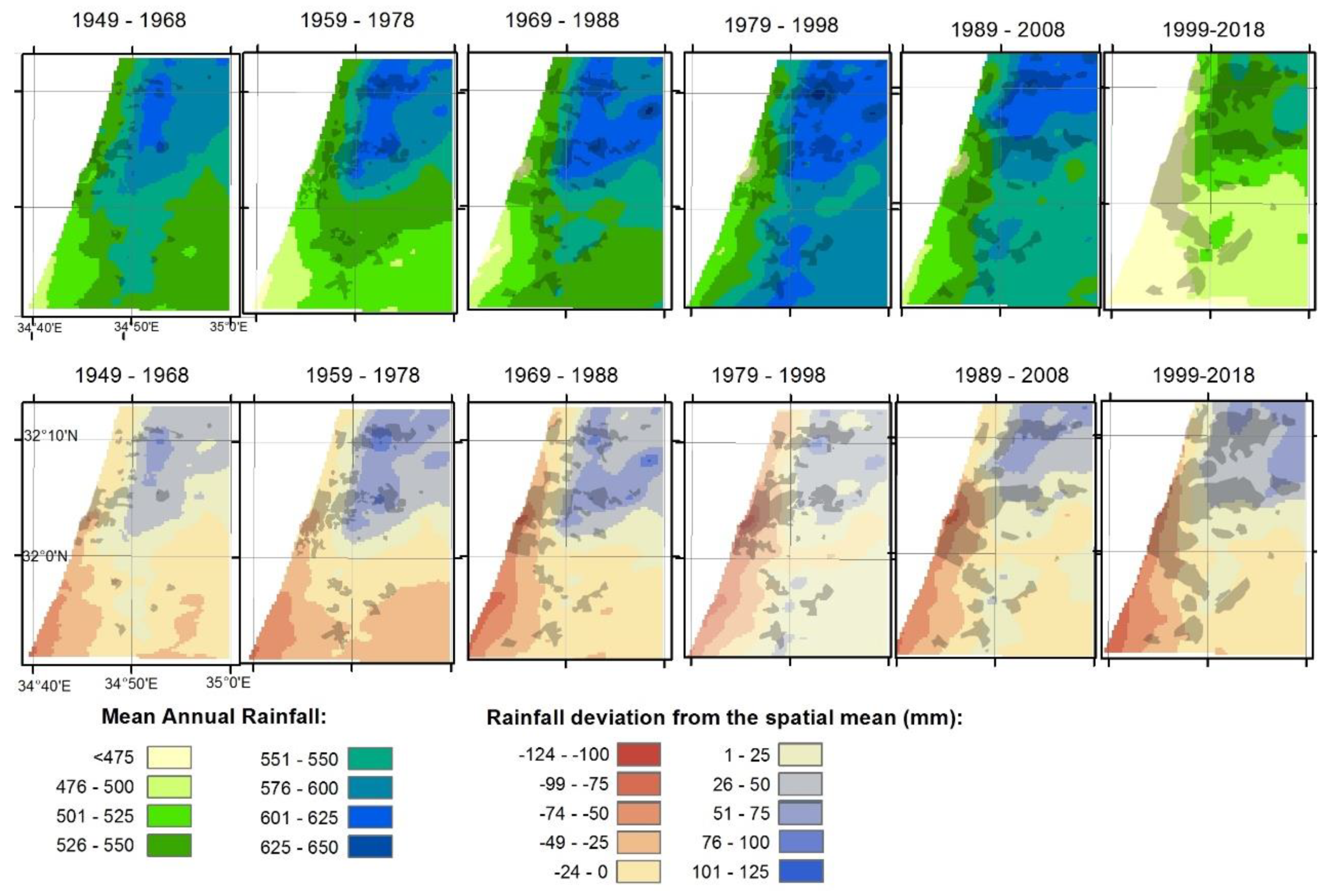
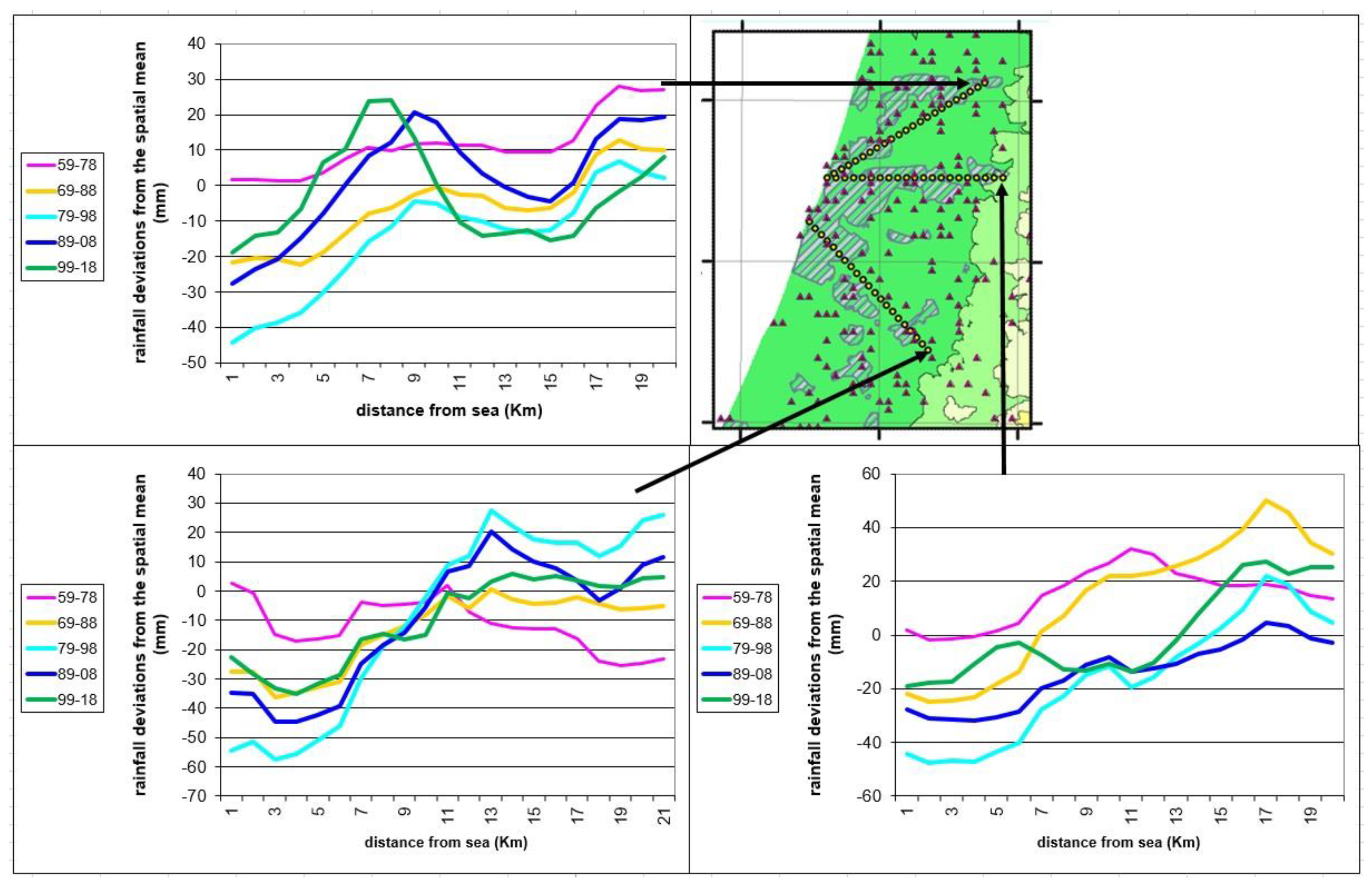
4. Results
5. Discussion
6. Conclusions
Author Contributions
Funding
Acknowledgments
Conflicts of Interest
References
- Goldreich, Y.; Manes, A. Urban effects on precipitation patterns in the greater Tel-Aviv area. Theor. Appl. Climato. 1979, 27, 213–224. [Google Scholar]
- Stanhill, G.; Rapaport, C. Temporal and Spatial Variation in the Volume of Rain Falling Annually in Israel. Isr. J. Earth Sci. 1988, 37, 211–221. [Google Scholar]
- Shafir, H.; Alpert, P. On the urban orographic rainfall anomaly in Jerusalem—A numerical study. Atmos. Environ. 1990, 3, 365–375. [Google Scholar] [CrossRef]
- Givati, A.; Rosenfeld, D. Quantifying Precipitation Suppression Due to Air Pollution. J. Appl. Meteorol. 2004, 43, 1038–1056. [Google Scholar] [CrossRef]
- Alpert, P.; Halfon, N.; Levin, Z. Does air pollution really suppress precipitation in Israel. J. Appl. Meteorol. Climatol. 2008, 47, 933–943. [Google Scholar] [CrossRef]
- Halfon, N.; Levin, Z.; Alpert, P. Temporal rainfall fluctuations in Israel and their possible link to urban and air pollution effects. Environ. Res. Lett. 2009, 4. [Google Scholar] [CrossRef]
- Oke, T.R. Review of Urban Climatology, 1973–1976; WMO Technical Note No. 169; WMO: Geneva, Switzerland, 1979; p. 539. [Google Scholar]
- Landsberg, H. The Urban Climate; Academic Press: New York, NY, USA, 1981. [Google Scholar]
- Shepherd, J.M. A Review of Current Investigations of Urban-Induced Rainfall and Recommendations for the Future. Earth Interact. 2005, 9, 1. [Google Scholar] [CrossRef]
- Van den Heever, S.C.; Cotton, W.R. Urban aerosol impacts on downwind convective storms. J. Appl. Meteorol. Climatol. 2007, 46, 828–850. [Google Scholar] [CrossRef]
- Teller, A.; Levin, Z. The effects of aerosols on precipitation and dimensions of subtropical clouds: A sensitivity study using a numerical cloud model. Atmos. Chem. Phys. 2006, 6, 67–80. [Google Scholar] [CrossRef]
- Van der Heever, S.C.; Rozoffand, C.; Cotton, W.R. Experience in Applying the Alpert-Stein Factor Separation Methodology to Assessing Urban Land-Use and Aerosol Impacts on Precipitation, in Factor Separation in the Atmosphere Application with Future Prospects; Alpert, P., Sholokhman, T., Eds.; Cambridge University Press: Cambridge, UK, 2011; pp. 120–145, 274. [Google Scholar]
- Levin, Z.; Cotton, W.R. Aerosol Pollution Impact on Precipitation: A Scientific Review; Springer: Berlin, Germany, 2009; p. 386. [Google Scholar]
- Bornstein, R.D.; Lin, Q. Urban heat islands and summertime convective thunderstorms in Atlanta: Three cases studies. Atmos. Environ. 2000, 34, 507–516. [Google Scholar] [CrossRef]
- Bornstein, R.D.; Johnson, D.S. Urban-rural wind velocity differences. Atmos. Environ. 1997, 11, 597–604. [Google Scholar] [CrossRef]
- Gaffen, D.; Bornstein, R.D. Case Study of Urban Interactions with a Synoptic Scale Cold Front. Meteorol. Atmos. Phys. 1988, 38, 185–194. [Google Scholar] [CrossRef]
- Terjung, W.H. The effect of a cyclonic storm on the energy fluxes at the urban interface—A preliminary experiment. Arch. Meteorol. Geophys. Biokl. Ser. B 1971, 19, 367–416. [Google Scholar] [CrossRef]
- Goldreich, Y. The Climate of Israel: Observation, Research and Application; Kluwer Academic Publishes: New York, NY, USA, 2003. [Google Scholar]
- Shay-El, Y.; Alpert, P. A diagnostic study of winter diabatic heating in the Mediterranean in relation with cyclones. Quart. J. R. Meteor. Soc. 1991, 117, 715–747. [Google Scholar] [CrossRef]
- Alpert, P.; Shay-El, Y. The moisture source for the winter cyclones in the Eastern Mediterranean. Isr. Meteor. Res. Pap. 1994, 5, 20–27. [Google Scholar]
- Alpert, P.; Reisin, T. An early winter polar air mass penetration to the eastern Mediterranean. Mon. Wea. Rev. 1986, 114, 1411–1418. [Google Scholar] [CrossRef]
- Alpert, P.; Getenio, B. One-level modelling for diagnosing surface winds over complex terrain. Part I: Comparison with 3-D modelling in Israel. Mon.Rev. Wea. 1988, 116, 2025–2046. [Google Scholar] [CrossRef]
- Alpert, P.; Osetinsky, I.; Ziv, B.; Shafir, H. Semi-objective classification for daily synoptic systems: Application to the Eastern Mediterranean climate change. Int. J. Climatol. 2004, 24, 1001–1011. [Google Scholar] [CrossRef]
- Hochman, A.; Bucchignani, E.; Gershtein, G.; Krichak, S.O.; Alpert, P.; Levi, Y.; Yosef, Y.; Carmona, Y.; Breitgand, J.; Mercoglianoc, P.; et al. Evaluation of regional COSMO-CLM climate simulations over the Eastern Mediterranean for the period 1979–2011. Int. J. Climatol. 2018, 38, 1161–1176. [Google Scholar] [CrossRef]
- Hochman, A.; Harpaz, T.; Saaronia, H.; Alpert, P. Synoptic classification in 21st century CMIP5 predictions over the Eastern Mediterranean with focus on cyclones. Int. J. Climatol. 2018, 38, 1476–1483. [Google Scholar] [CrossRef]
- Samuels, R.; Hochman, A.; Baharad, A.; Givati, A.; Levi, Y.; Yosef, Y.; Saaroni, H.; Ziv, B.; Harpaza, T.; Alpert, P. Evaluation and projection of extreme precipitation indices in the Eastern Mediterranean based on CMIP5 multi-model ensemble. Int. J. Clim. 2017, 11. [Google Scholar] [CrossRef]
- Halfon, N. Spatial Patterns of Precipitation in Israel and Their Synoptic Characteristics. Ph.D. Thesis, Haifa University, Haifa, Israel, 2008. [Google Scholar]
- Ziv, B.; Saaroni, H.; Pargament, R.; Harpaz, T.; Alpert, P. Trends in Rainfall Regime over Israel, 1975–2010, and their Relationship to Large-Scale Variability. Reg. Environ. Changes 2013, 14. [Google Scholar] [CrossRef]
- Margalit, T. High Rise Building in Tel-Aviv 1953–2001—A Politics of “Random” Order. Ph.D. Thesis, Tel-Aviv University, Tel Aviv, Israel, 2001. [Google Scholar]
- MAPI. Available online: http://mapi.gov.il/en/Pages/default.aspx (accessed on 5 March 2019).
- Changnon, S.A., Jr.; Huff, F.A.; Semonin, R.G. MTROMEX: An investigation of inadvertent weather modification. Bull. Amer. Met. Soc. 1971, 52, 958–968. [Google Scholar] [CrossRef]
- Carri´o, G.G.; Cotton, W.R.; Cheng, W.Y.Y. Urban growth and aerosol effects on convection over Houston, Part I: the August 2000 case. Atmos. Res. 2010, 96, 560–574. [Google Scholar]
- Itzhak-Ben-Shalom, H.; Alpert, P.; Potchter, O.; Samuels, R. MODIS summer SUHI cross-sections anomalies over the megacities of the monsoon Asia region and global trends. Open Atmos. Sci. J. 2017, 11, 121–136. [Google Scholar] [CrossRef]
- Alpert, P.; Sholokhman, T. Factor Separation in the Atmosphere, Applications and Future Prospects; Cambridge University Press: Cambridge, UK, 2011; p. 274. [Google Scholar]
- Kishcha, P.; Nickovic, S.; Starobinets, B.; di Sarra, A.; Udisti, R.; Becagli, S.; Sferlazzo, D.; Bommarito, C.; Alpert, P. Sea-salt aerosol forecasts compared with daily measurements at the island of Lampedusa. Atmos. Res. 2011, 100, 28–35. [Google Scholar] [CrossRef]
- Alpert, P.; Krichak, S.O.; Tsidulko, M.; Shafir, H.; Joseph, J.H. A dust prediction system with TOMS initialization. Mon. Wea. Rev. 2002, 130, 2335–2345. [Google Scholar] [CrossRef]


| Year | 1948 | 1958 | 1968 | 1978 | 1988 | 1998 | 2008 | |
|---|---|---|---|---|---|---|---|---|
| Municipality | ||||||||
| Kernel (zone 1 in Figure) | Tel Aviv-Jaffa | 248,260 | 383,000 | 384,700 | 339,800 | 317,000 | 348,000 | 392,000 |
| First ring (zone 2 in Figure) | Giv’atayim | 9635 | 26,000 | 42,000 | 49,000 | 45,600 | 46,800 | 49,900 |
| Ramat-Gan | 17,182 | 77,000 | 109,400 | 120,300 | 115,700 | 126,900 | 134,000 | |
| Bnei-Brak | 8834 | 36,600 | 67,000 | 87,300 | 109,400 | 133,900 | 153,000 | |
| Holon | 9568 | 40,000 | 80,000 | 124,500 | 146,000 | 163,000 | 170,000 | |
| Bat-Yam | 2331 | 21,000 | 68,900 | 126,000 | 133,000 | 137,000 | 129,000 | |
| Second ring (zone 3 in Figure) | Petah Tikva | 21,589 | 49,000 | 76,700 | 114,400 | 133,600 | 160,000 | 193,000 |
| Rishon-Lezion | 10,445 | 24,000 | 42,000 | 83,400 | 123,000 | 188,000 | 226,000 |
| Period | 1953–1967 | 1968–1977 | 1978–1988 | 1989–2001 |
|---|---|---|---|---|
| 6–15 floors | 68 | 269 | 127 | 256 |
| 15–30 floors | 3 | 20 | 33 | 37 |
| >30 floors | 1 | 0 | 1 | 6 |
© 2019 by the authors. Licensee MDPI, Basel, Switzerland. This article is an open access article distributed under the terms and conditions of the Creative Commons Attribution (CC BY) license (http://creativecommons.org/licenses/by/4.0/).
Share and Cite
Alpert, P.; Radian, R.; Halfon, N.; Levin, Z. Urban Rainfall Anomaly under Intensive Development, 1949–2018, Case of Tel-Aviv, Israel. Atmosphere 2019, 10, 163. https://doi.org/10.3390/atmos10040163
Alpert P, Radian R, Halfon N, Levin Z. Urban Rainfall Anomaly under Intensive Development, 1949–2018, Case of Tel-Aviv, Israel. Atmosphere. 2019; 10(4):163. https://doi.org/10.3390/atmos10040163
Chicago/Turabian StyleAlpert, Pinhas, Ronen Radian, Noam Halfon, and Zev Levin. 2019. "Urban Rainfall Anomaly under Intensive Development, 1949–2018, Case of Tel-Aviv, Israel" Atmosphere 10, no. 4: 163. https://doi.org/10.3390/atmos10040163
APA StyleAlpert, P., Radian, R., Halfon, N., & Levin, Z. (2019). Urban Rainfall Anomaly under Intensive Development, 1949–2018, Case of Tel-Aviv, Israel. Atmosphere, 10(4), 163. https://doi.org/10.3390/atmos10040163