

Unveiling the Potential of Agricultural Soil Loss Mitigation in Poland: Assessing Conservation Management and Support Practices


Abstract
1. Introduction
2. Materials and Methods
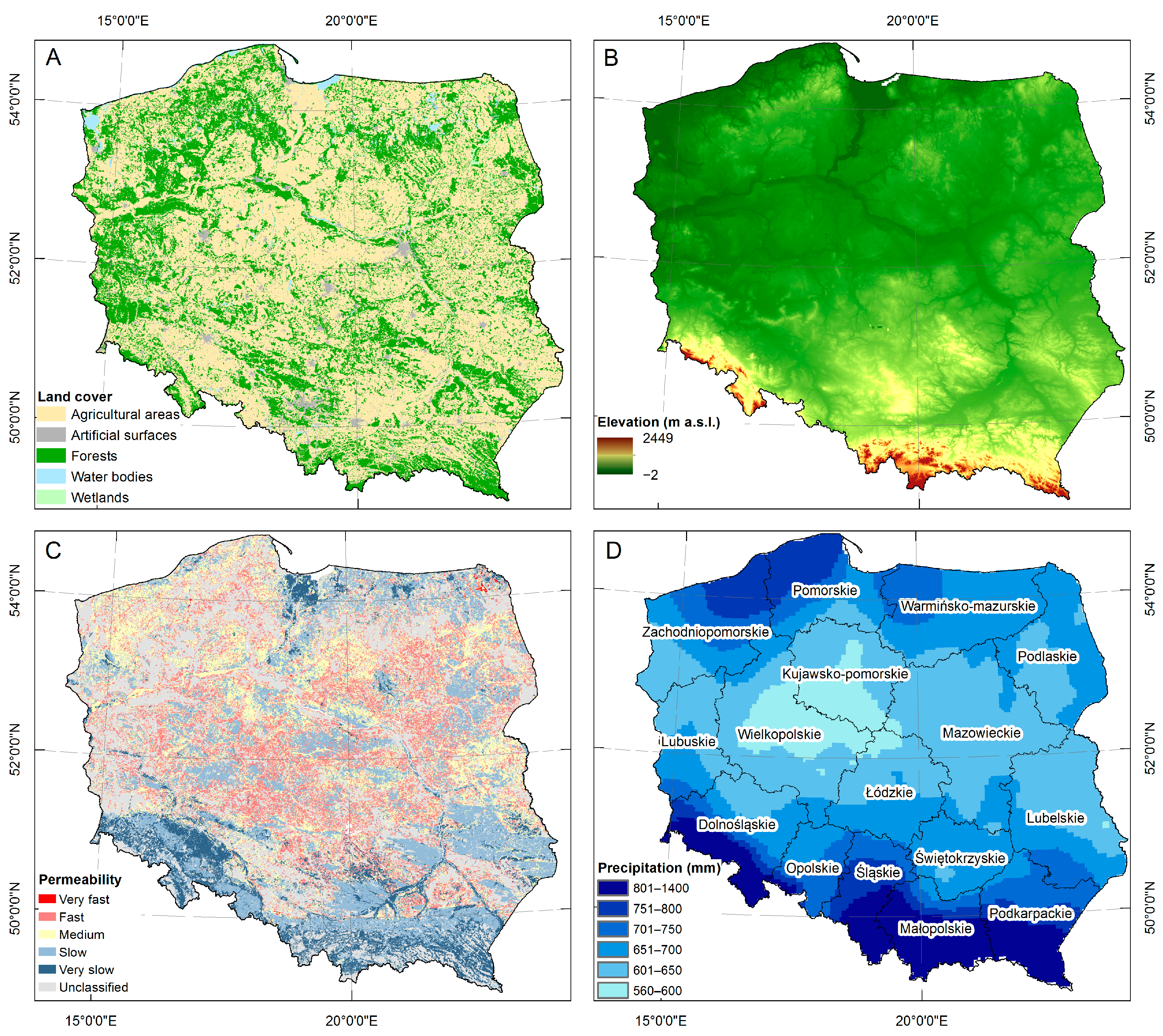
2.1. Research Area
2.2. RUSLE Model
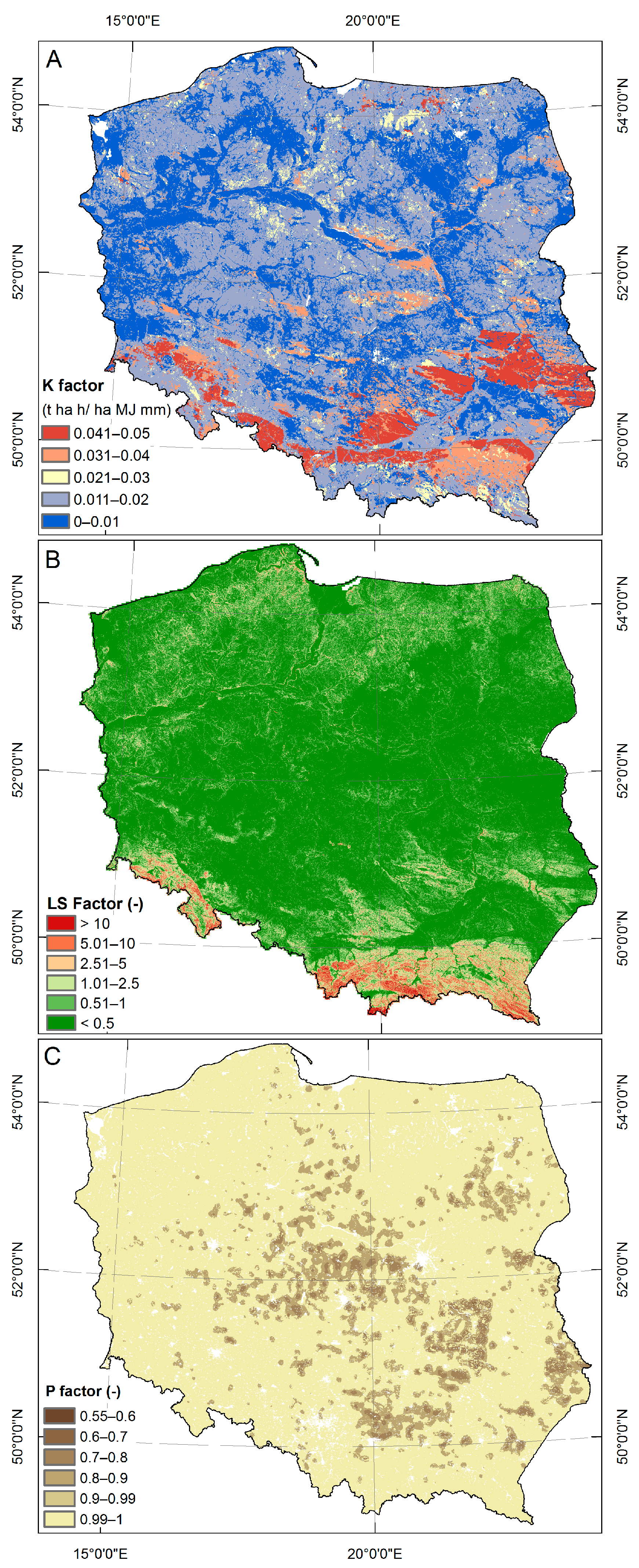
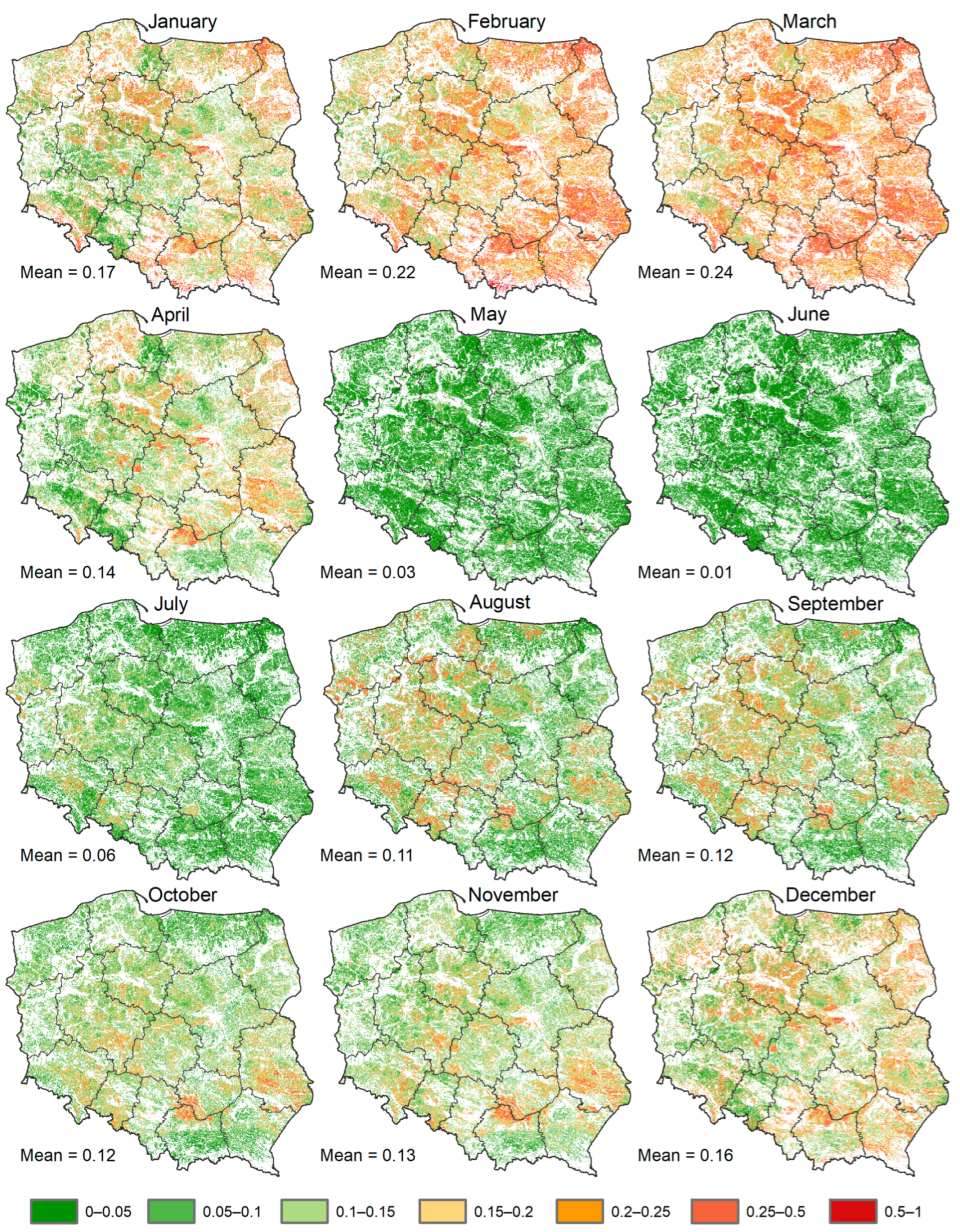
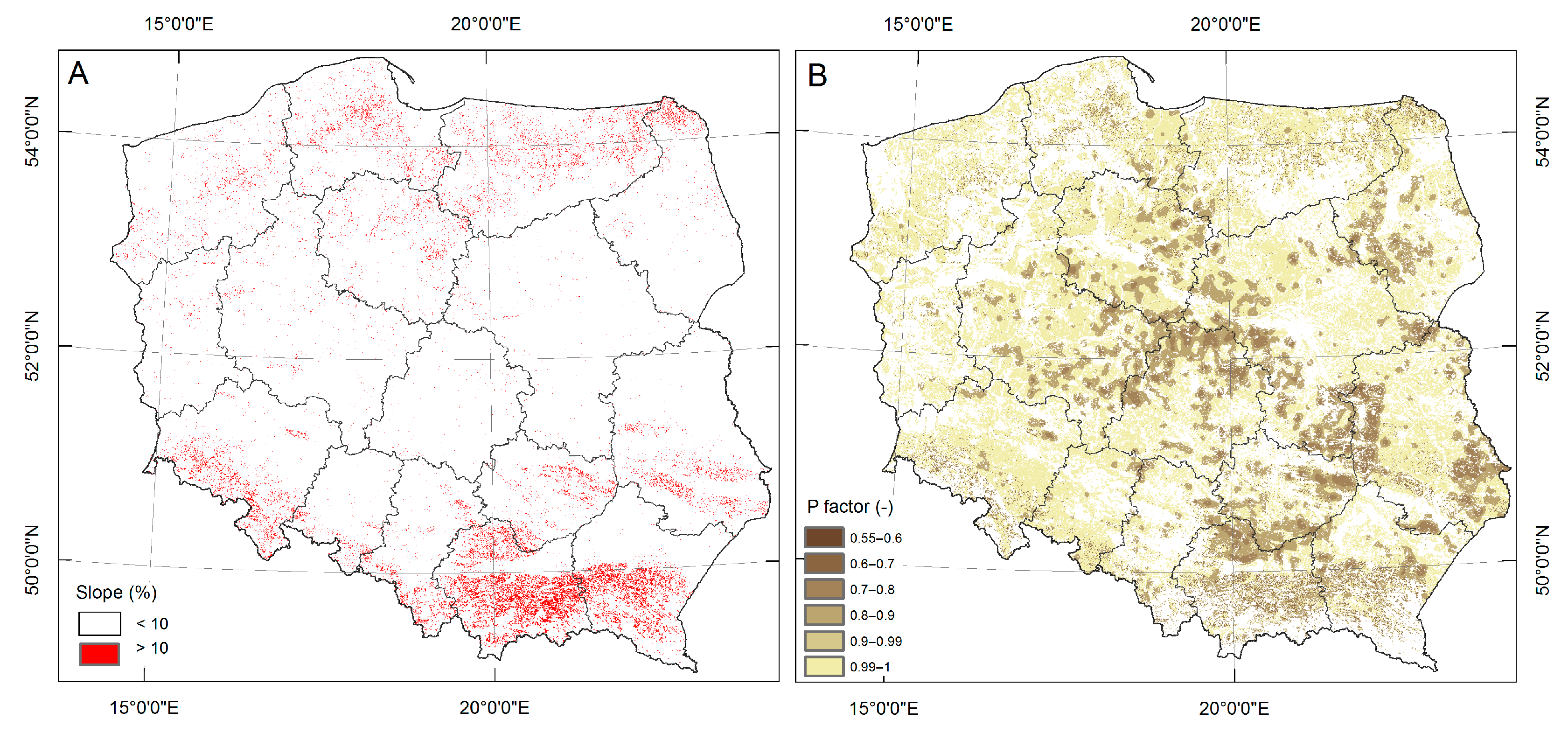
2.3. Research Factors
2.4. Agricultural Conservation Practices
2.4.1. Conservation Practices Assumptions
2.4.2. Management Factor and Support Practice Factor Scenario
2.4.3. Scenario Application
3. Results
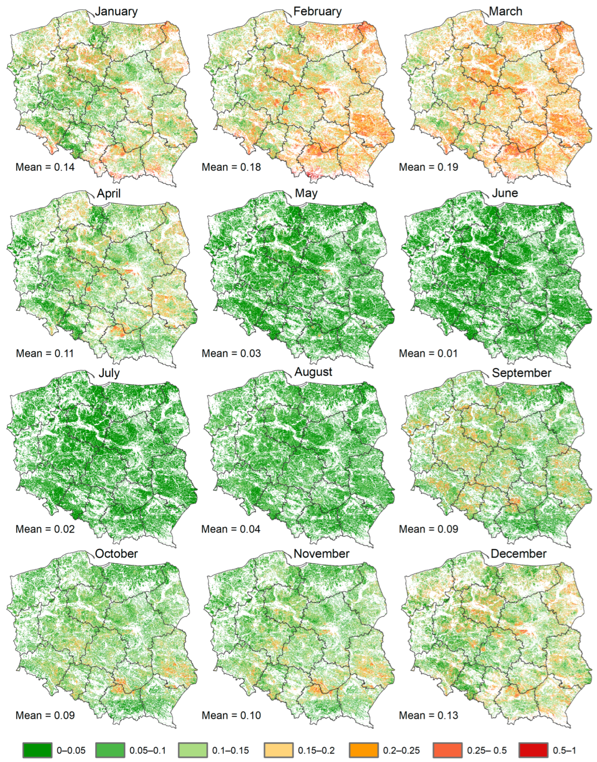
3.1. Current Soil Erosion in Arable Lands
3.2. Application of Agricultural Conservation Measures
3.3. Efficiency of Soil Loss Reduction
4. Discussion
5. Conclusions
Funding
Data Availability Statement
Conflicts of Interest
References
- Montgomery, D.R. Soil erosion and agricultural sustainability. Proc. Natl. Acad. Sci. USA 2007, 104, 13268–13272. [Google Scholar] [CrossRef] [PubMed]
- Delgado-Baquerizo, M.; Reich, P.B.; Trivedi, C.; Eldridge, D.J.; Abades, S.; Alfaro, F.D.; Bastida, F.; Berhe, A.A.; Cutler, N.A.; Gallardo, A. Multiple elements of soil biodiversity drive ecosystem functions across biomes. Nat. Ecol. Evol. 2020, 4, 210–220. [Google Scholar] [CrossRef]
- Kopittke, P.M.; Menzies, N.W.; Wang, P.; McKenna, B.A.; Lombi, E. Soil and the intensification of agriculture for global food security. Environ. Int. 2019, 132, 105078. [Google Scholar] [CrossRef] [PubMed]
- Borrelli, P.; Alewell, C.; Alvarez, P.; Anache, J.A.A.; Baartman, J.; Ballabio, C.; Bezak, N.; Biddoccu, M.; Cerdà, A.; Chalise, D.; et al. Soil erosion modelling: A global review and statistical analysis. Sci. Total Environ. 2021, 780, 146494. [Google Scholar] [CrossRef] [PubMed]
- Panagos, P.; Borrelli, P.; Poesen, J.; Ballabio, C.; Lugato, E.; Meusburger, K.; Montanarella, L.; Alewell, C. The new assessment of soil loss by water erosion in Europe. Environ. Sci. Policy 2015, 54, 438–447. [Google Scholar] [CrossRef]
- Hurni, H.; Herweg, K.; Portner, B.; Liniger, H. Soil erosion and conservation in global agriculture. In Land Use and Soil Resources; Springer: Dordrecht, The Netherlands, 2008; pp. 41–71. [Google Scholar]
- Borrelli, P.; Van Oost, K.; Meusburger, K.; Alewell, C.; Lugato, E.; Panagos, P. A step towards a holistic assessment of soil degradation in Europe: Coupling on-site erosion with sediment transfer and carbon fluxes. Environ. Res. 2018, 161, 291–298. [Google Scholar] [CrossRef]
- Bradford, J.; Ferris, J.; Remley, P. Interrill soil erosion processes: I. Effect of surface sealing on infiltration, runoff, and soil splash detachment. Soil Sci. Soc. Am. J. 1987, 51, 1566–1571. [Google Scholar] [CrossRef]
- Morgan, R. Soil degradation and erosion as a result of agricultural practice. In Geomorphology and Soils; Routledge: Oxfordshire, UK, 2020; pp. 379–395. [Google Scholar]
- Li, H.; Zhu, H.; Wei, X.; Liu, B.; Shao, M. Soil erosion leads to degradation of hydraulic properties in the agricultural region of Northeast China. Agric. Ecosyst. Environ. 2021, 314, 107388. [Google Scholar] [CrossRef]
- Dutta, S. Soil erosion, sediment yield and sedimentation of reservoir: A review. Model. Earth Syst. Environ. 2016, 2, 123. [Google Scholar] [CrossRef]
- Lal, R. Food security in a changing climate. Ecohydrol. Hydrobiol. 2013, 13, 8–21. [Google Scholar] [CrossRef]
- Li, Z.; Fang, H. Impacts of climate change on water erosion: A review. Earth-Sci. Rev. 2016, 163, 94–117. [Google Scholar] [CrossRef]
- Ahmad, N.S.B.N.; Mustafa, F.B.; Didams, G. A systematic review of soil erosion control practices on the agricultural land in Asia. Int. Soil Water Conserv. Res. 2020, 8, 103–115. [Google Scholar] [CrossRef]
- Ricci, G.; Jeong, J.; De Girolamo, A.; Gentile, F. Effectiveness and feasibility of different management practices to reduce soil erosion in an agricultural watershed. Land Use Policy 2020, 90, 104306. [Google Scholar] [CrossRef]
- Stevens, C.J.; Quinton, J.N.; Bailey, A.; Deasy, C.; Silgram, M.; Jackson, D. The effects of minimal tillage, contour cultivation and in-field vegetative barriers on soil erosion and phosphorus loss. Soil Tillage Res. 2009, 106, 145–151. [Google Scholar] [CrossRef]
- Kairis, O.; Karavitis, C.; Kounalaki, A.; Salvati, L.; Kosmas, C. The effect of land management practices on soil erosion and land desertification in an olive grove. Soil Use Manag. 2013, 29, 597–606. [Google Scholar] [CrossRef]
- Borrelli, P.; Meusburger, K.; Ballabio, C.; Panagos, P.; Alewell, C. Object-oriented soil erosion modelling: A possible paradigm shift from potential to actual risk assessments in agricultural environments. Land Degrad. Dev. 2018, 29, 1270–1281. [Google Scholar] [CrossRef]
- Panagos, P.; Borrelli, P.; Meusburger, K.; Alewell, C.; Lugato, E.; Montanarella, L. Estimating the soil erosion cover-management factor at the European scale. Land Use Policy 2015, 48, 38–50. [Google Scholar] [CrossRef]
- Renard, K.G. Predicting Soil Erosion by Water: A Guide to Conservation Planning with the Revised Universal Soil Loss Equation (RUSLE); US Department of Agriculture, Agricultural Research Service: Washington, DC, USA, 1997.
- Panagos, P.; Borrelli, P.; Meusburger, K.; van der Zanden, E.H.; Poesen, J.; Alewell, C. Modelling the effect of support practices (P-factor) on the reduction of soil erosion by water at European scale. Environ. Sci. Policy 2015, 51, 23–34. [Google Scholar] [CrossRef]
- Ebabu, K.; Tsunekawa, A.; Haregeweyn, N.; Tsubo, M.; Adgo, E.; Fenta, A.A.; Meshesha, D.T.; Berihun, M.L.; Sultan, D.; Vanmaercke, M. Global analysis of cover management and support practice factors that control soil erosion and conservation. Int. Soil Water Conserv. Res. 2022, 10, 161–176. [Google Scholar] [CrossRef]
- Hudecová, Ľ.; Geisse, R.; Gašincová, S.; Bajtala, M. Quantification of land fragmentation in Slovakia. Geod. List 2017, 71, 327–338. [Google Scholar]
- Petrescu-Mag, R.M.; Petrescu, D.C.; Petrescu-Mag, I.V. Whereto land fragmentation–land grabbing in Romania? The place of negotiation in reaching win–win community-based solutions. Land Use Policy 2017, 64, 174–185. [Google Scholar] [CrossRef]
- Todorova, A. Economic and social effects of land fragmentation on Bulgarian agriculture. J. Cent. Eur. Agric. 2005, 6, 555–562. [Google Scholar]
- Marcinkowski, P.; Szporak-Wasilewska, S.; Kardel, I. Assessment of soil erosion under long-term projections of climate change in Poland. J. Hydrol. 2022, 607, 127468. [Google Scholar] [CrossRef]
- Marcinkowski, P.; Szporak-Wasilewska, S. Assessing monthly dynamics of agricultural soil erosion risk in Poland. Geoderma Reg. 2024, 39, e00864. [Google Scholar] [CrossRef]
- Halecki, W.; Kruk, E.; Ryczek, M. Evaluation of water erosion at a mountain catchment in Poland using the G2 model. CATENA 2018, 164, 116–124. [Google Scholar] [CrossRef]
- Nowak, A.; Schneider, C. Environmental characteristics, agricultural land use, and vulnerability to degradation in Malopolska Province (Poland). Sci. Total Environ. 2017, 590–591, 620–632. [Google Scholar] [CrossRef]
- Halecki, W.; Kruk, E.; Ryczek, M. Loss of topsoil and soil erosion by water in agricultural areas: A multi-criteria approach for various land use scenarios in the Western Carpathians using a SWAT model. Land Use Policy 2018, 73, 363–372. [Google Scholar] [CrossRef]
- Świtoniak, M. Use of soil profile truncation to estimate influence of accelerated erosion on soil cover transformation in young morainic landscapes, North-Eastern Poland. CATENA 2014, 116, 173–184. [Google Scholar] [CrossRef]
- Chowaniak, M.; Głąb, T.; Klima, K.; Niemiec, M.; Zaleski, T.; Zuzek, D. Effect of tillage and crop management on runoff, soil erosion and organic carbon loss. Soil Use Manag. 2020, 36, 581–593. [Google Scholar] [CrossRef]
- Gil, E.; Kijowska-Strugała, M.; Demczuk, P. Soil erosion dynamics on a cultivated slope in the Western Polish Carpathians based on over 30 years of plot studies. CATENA 2021, 207, 105682. [Google Scholar] [CrossRef]
- Geoportal. Digital Elevation Model. 2024. Available online: https://www.geoportal.gov.pl/ (accessed on 18 January 2024).
- Panagos, P.; Van Liedekerke, M.; Borrelli, P.; Köninger, J.; Ballabio, C.; Orgiazzi, A.; Lugato, E.; Liakos, L.; Hervas, J.; Jones, A.; et al. European Soil Data Centre 2.0: Soil data and knowledge in support of the EU policies. Eur. J. Soil Sci. 2022, 73, e13315. [Google Scholar] [CrossRef]
- IMGW. Daily Precipitation Dataset. 2024. Available online: https://danepubliczne.imgw.pl/data/dane_pomiarowo_obserwacyjne/ (accessed on 17 January 2024).
- CLC. Corine Land Cover. 2018. Available online: https://land.copernicus.eu/en/products/corine-land-cover (accessed on 15 January 2024).
- Czyżewski, B.; Brelik, A. Sustainable development of agriculture–case of Poland. Roczniki (Annals) 2014, 2014, 38–43. [Google Scholar]
- Rogalski, D.; Jabłoński, S. Skala zagrożenia erozją oraz program ochrony przeciwerozyjnej gleb na przykładzie województwa bydgoskiego. Przegląd Geod. 1983, 8, 29–30. [Google Scholar]
- Panagos, P.; Hengl, T.; Wheeler, I.; Marcinkowski, P.; Rukeza, M.B.; Yu, B.; Yang, J.E.; Miao, C.; Chattopadhyay, N.; Sadeghi, S.H.; et al. Global rainfall erosivity database (GloREDa) and monthly R-factor data at 1 km spatial resolution. Data Brief 2023, 50, 109482. [Google Scholar] [CrossRef] [PubMed]
- Van der Knijff, J.; Jones, R.; Montanarella, L. Soil Erosion Risk Assessment in Europe; European Soil Bureau: Ispra, Italy; European Commission: Brussels, Belgium, 2000. [Google Scholar]
- Stone, R.; Hilborn, D. Universal Soil Loss Equation (USLE) Factsheet Order No. 12-051; Ministry of Agriculture, Food and Rural Affairs: Guelph, ON, Canada, 2011; pp. 1198–1712. [Google Scholar]
- Kijowska-Strugała, M.; Bucała-Hrabia, A.; Demczuk, P. Long-term impact of land use changes on soil erosion in an agricultural catchment (in the Western Polish Carpathians). Land Degrad. Dev. 2018, 29, 1871–1884. [Google Scholar] [CrossRef]
- Morgan, R.P.C. Soil Erosion and Conservation; John Wiley & Sons: Hoboken, NJ, USA, 2009. [Google Scholar]
- Latocha, A.; Szymanowski, M.; Jeziorska, J.; Stec, M.; Roszczewska, M. Effects of land abandonment and climate change on soil erosion—An example from depopulated agricultural lands in the Sudetes Mts., SW Poland. CATENA 2016, 145, 128–141. [Google Scholar] [CrossRef]
- Drzewiecki, W.; Wężyk, P.; Pierzchalski, M.; Szafrańska, B. Quantitative and Qualitative Assessment of Soil Erosion Risk in Małopolska (Poland), Supported by an Object-Based Analysis of High-Resolution Satellite Images. Pure Appl. Geophys. 2014, 171, 867–895. [Google Scholar] [CrossRef]
- Poręba, G.; Śnieszko, Z.; Moska, P.; Mroczek, P.; Malik, I. Interpretation of soil erosion in a Polish loess area using OSL, 137Cs, 210Pbex, dendrochronology and micromorphology–case study: Biedrzykowice site (s Poland). Geochronometria 2019, 46, 57–78. [Google Scholar] [CrossRef]
- Mhazo, N.; Chivenge, P.; Chaplot, V. Tillage impact on soil erosion by water: Discrepancies due to climate and soil characteristics. Agric. Ecosyst. Environ. 2016, 230, 231–241. [Google Scholar] [CrossRef]
- Borrelli, P.; Märker, M.; Schütt, B. Modelling post-tree-harvesting soil erosion and sediment deposition potential in the Turano River Basin (Italian Central Apennine). Land Degrad. Dev. 2015, 26, 356–366. [Google Scholar] [CrossRef]
- Novara, A.; Pisciotta, A.; Minacapilli, M.; Maltese, A.; Capodici, F.; Cerdà, A.; Gristina, L. The impact of soil erosion on soil fertility and vine vigor. A multidisciplinary approach based on field, laboratory and remote sensing approaches. Sci. Total Environ. 2018, 622, 474–480. [Google Scholar] [CrossRef] [PubMed]
- Panagos, P.; Standardi, G.; Borrelli, P.; Lugato, E.; Montanarella, L.; Bosello, F. Cost of agricultural productivity loss due to soil erosion in the European Union: From direct cost evaluation approaches to the use of macroeconomic models. Land Degrad. Dev. 2018, 29, 471–484. [Google Scholar] [CrossRef]
- Madeyski, M.; Michalec, B.; Tarnawski, M. Silting of small water reservoirs and quality of sediments. Infrastruct. Ecol. Rural Areas 2008, 11, 1–76. [Google Scholar]
- Panagos, P.; Matthews, F.; Patault, E.; De Michele, C.; Quaranta, E.; Bezak, N.; Kaffas, K.; Patro, E.R.; Auel, C.; Schleiss, A.J.; et al. Understanding the cost of soil erosion: An assessment of the sediment removal costs from the reservoirs of the European Union. J. Clean. Prod. 2024, 434, 140183. [Google Scholar] [CrossRef]
- Smoroń, S. The risk of surface waters eutrophication in loessial uplands of Małopolska. Woda Sr. Obsz. Wiej. 2012, 45, 181–191. [Google Scholar]
- Verheijen, F.G.A.; Jones, R.J.A.; Rickson, R.J.; Smith, C.J. Tolerable versus actual soil erosion rates in Europe. Earth-Sci. Rev. 2009, 94, 23–38. [Google Scholar] [CrossRef]
- Kumar, M.; Sahu, A.P.; Sahoo, N.; Dash, S.S.; Raul, S.K.; Panigrahi, B. Global-scale application of the RUSLE model: A comprehensive review. Hydrol. Sci. J. 2022, 67, 806–830. [Google Scholar] [CrossRef]
- Ganasri, B.; Ramesh, H. Assessment of soil erosion by RUSLE model using remote sensing and GIS-A case study of Nethravathi Basin. Geosci. Front. 2016, 7, 953–961. [Google Scholar] [CrossRef]
- Galdino, S.; Sano, E.E.; Andrade, R.G.; Grego, C.R.; Nogueira, S.F.; Bragantini, C.; Flosi, A.H.G. Large-scale Modeling of Soil Erosion with RUSLE for Conservationist Planning of Degraded Cultivated Brazilian Pastures. Land Degrad. Dev. 2016, 27, 773–784. [Google Scholar] [CrossRef]
- Schmaltz, E.M.; Krammer, C.; Dersch, G.; Weinberger, C.; Kuderna, M.; Strauss, P. The effectiveness of soil erosion measures for cropland in the Austrian Agri-environmental Programme: A national approach using local data. Agric. Ecosyst. Environ. 2023, 355, 108590. [Google Scholar] [CrossRef]
- Sadowski, A.; Czubak, W. Ocena i efekty funkcjonowania programu rolnośrodowiskowego w Wielkopolsce. Rocz. Nauk. Stowarzyszenia Ekon. Rol. I Agrobiznesu 2010, 12, 303–308. [Google Scholar]
- Václavík, T.; Beckmann, M.; Bednář, M.; Brdar, S.; Breckenridge, G.; Cord, A.F.; Domingo-Marimon, C.; Gosal, A.; Langerwisch, F.; Paulus, A. Farming system archetypes help explain the uptake of agri-environment practices in Europe. Environ. Res. Lett. 2024, 19, 074004. [Google Scholar] [CrossRef]
- Kundzewicz, Z.W.; Piniewski, M.; Mezghani, A.; Okruszko, T.; Pińskwar, I.; Kardel, I.; Hov, Ø.; Szcześniak, M.; Szwed, M.; Benestad, R.E.; et al. Assessment of climate change and associated impact on selected sectors in Poland. Acta Geophys. 2018, 66, 1509–1523. [Google Scholar] [CrossRef]
- Marcinkowski, P.; Piniewski, M. Future changes in crop yield over Poland driven by climate change, increasing atmospheric CO2 and nitrogen stress. Agric. Syst. 2024, 213, 103813. [Google Scholar] [CrossRef]
- Marcinkowski, P.; Piniewski, M.; Jefimow, M. Assessment of projected climate change impact on agro-climatic indicators in Poland. Int. J. Clim. 2023, 43, 6003–6019. [Google Scholar] [CrossRef]
- Osuch, M.; Romanowicz, R.J.; Lawrence, D.; Wong, W.K. Trends in projections of standardized precipitation indices in a future climate in Poland. Hydrol. Earth Syst. Sci. 2016, 20, 1947–1969. [Google Scholar] [CrossRef]
- Alewell, C.; Borrelli, P.; Meusburger, K.; Panagos, P. Using the USLE: Chances, challenges and limitations of soil erosion modelling. Int. Soil Water Conserv. Res. 2019, 7, 203–225. [Google Scholar] [CrossRef]


| RUSLE Parameter | Range | Mean | Standard Deviation | Source |
|---|---|---|---|---|
| K-factor t (ha h ha−1 MJ−1 mm−1) | 0.003–0.05 | 0.016 | 0.009 | [26] |
| LS-factor (dimensionless) | 0.04–163 | 0.47 | 1.42 | [26] |
| P-factor (dimensionless) | 0.55–1 | 0.9781 | 0.056 | [21] |
| R-factor January (MJ mm ha−1 h−1 month−1) * | 0–42 | 1.6 | 2.8 | [40] |
| R-factor February | 0–37 | 0.3 | 1.1 | [40] |
| R-factor March | 0–44 | 1.5 | 2.6 | [40] |
| R-factor April | 3–111 | 12.3 | 5.5 | [40] |
| R-factor May | 29–321 | 62.2 | 22.9 | [40] |
| R-factor June | 59–400 | 108.7 | 33.9 | [40] |
| R-factor July | 70–470 | 165.8 | 42.2 | [40] |
| R-factor August | 47–358 | 114.3 | 24.9 | [40] |
| R-factor September | 24–218 | 49.5 | 15.8 | [40] |
| R-factor October | 12–95 | 22.4 | 6.8 | [40] |
| R-factor November | 3–66 | 11.6 | 4.3 | [40] |
| R-factor December | 0–44 | 4.4 | 3.7 | [40] |
| C-factor January (dimensionless) | 0–1 | 0.17 | 0.09 | [27] |
| C-factor February | 0–1 | 0.22 | 0.09 | [27] |
| C-factor March | 0–1 | 0.24 | 0.07 | [27] |
| C-factor April | 0–1 | 0.14 | 0.07 | [27] |
| C-factor May | 0–1 | 0.03 | 0.02 | [27] |
| C-factor June | 0–1 | 0.01 | 0.01 | [27] |
| C-factor July | 0–1 | 0.06 | 0.05 | [27] |
| C-factor August | 0–1 | 0.11 | 0.08 | [27] |
| C-factor September | 0–1 | 0.12 | 0.09 | [27] |
| C-factor October | 0–1 | 0.12 | 0.06 | [27] |
| C-factor November | 0–1 | 0.13 | 0.06 | [27] |
| C-factor December | 0–1 | 0.16 | 0.08 | [27] |
| Voivodeship | Jan | Feb | Mar | Apr | May | Jun | Jul | Aug | Sep | Oct | Nov | Dec | Total | % of National Total | Ratio of Total Erosion and Total Arable Land Area (kt km−2) |
|---|---|---|---|---|---|---|---|---|---|---|---|---|---|---|---|
| Śląskie | 5 | 3 | 14 | 21 | 9 | 6 | 48 | 61 | 34 | 18 | 15 | 7 | 242 | 5% | 0.05 |
| Opolskie | 0 | 0 | 1 | 7 | 6 | 3 | 87 | 107 | 55 | 17 | 8 | 1 | 292 | 6% | 0.05 |
| Wielkopolskie | 2 | 0 | 1 | 6 | 8 | 9 | 75 | 80 | 34 | 13 | 7 | 4 | 237 | 5% | 0.01 |
| Zachodniopomorskie | 7 | 1 | 6 | 8 | 6 | 4 | 54 | 77 | 31 | 13 | 7 | 10 | 225 | 5% | 0.02 |
| Świętokrzyskie | 0 | 0 | 0 | 23 | 20 | 9 | 80 | 106 | 58 | 28 | 13 | 1 | 338 | 7% | 0.06 |
| Kujawsko-pomorskie | 0 | 0 | 0 | 7 | 11 | 7 | 65 | 84 | 35 | 14 | 8 | 3 | 233 | 5% | 0.02 |
| Podlaskie | 0 | 0 | 0 | 8 | 8 | 4 | 15 | 28 | 16 | 9 | 6 | 2 | 96 | 2% | 0.01 |
| Dolnośląskie | 7 | 1 | 9 | 24 | 14 | 8 | 135 | 169 | 74 | 35 | 18 | 9 | 504 | 11% | 0.05 |
| Podkarpackie | 0 | 0 | 17 | 43 | 16 | 8 | 51 | 66 | 49 | 38 | 23 | 19 | 330 | 7% | 0.05 |
| Małopolskie | 8 | 3 | 33 | 81 | 38 | 21 | 99 | 143 | 85 | 59 | 40 | 19 | 628 | 13% | 0.09 |
| Pomorskie | 4 | 0 | 1 | 8 | 8 | 4 | 41 | 75 | 32 | 16 | 10 | 8 | 206 | 4% | 0.03 |
| Warmińsko-mazurskie | 3 | 1 | 2 | 12 | 9 | 4 | 40 | 84 | 37 | 17 | 15 | 7 | 231 | 5% | 0.02 |
| Łódzkie | 0 | 0 | 0 | 6 | 6 | 5 | 49 | 52 | 22 | 9 | 7 | 2 | 158 | 3% | 0.02 |
| Mazowieckie | 0 | 0 | 0 | 8 | 10 | 7 | 42 | 55 | 27 | 11 | 7 | 2 | 169 | 4% | 0.01 |
| Lubelskie | 0 | 0 | 0 | 39 | 35 | 9 | 143 | 239 | 137 | 57 | 22 | 8 | 689 | 15% | 0.05 |
| Lubuskie | 1 | 0 | 1 | 2 | 2 | 3 | 24 | 23 | 9 | 4 | 2 | 2 | 74 | 2% | 0.02 |
| Total | 37 | 10 | 86 | 302 | 207 | 108 | 1050 | 1449 | 734 | 358 | 208 | 102 | 4652 | 100% | 0.03 |
| Voivodeship | Area (km2) | Area of Arable Lands (km2) | Share of Arable Lands (%) | Area of P-Factor Change (km2) | Share of P-Factor Change on Arable Lands (%) |
|---|---|---|---|---|---|
| Śląskie | 12,317 | 4557 | 37 | 480 | 10.5 |
| Opolskie | 9400 | 5429 | 58 | 225 | 4.1 |
| Wielkopolskie | 29,797 | 16,935 | 57 | 224 | 1.3 |
| Zachodniopomorskie | 22,896 | 9328 | 41 | 538 | 5.8 |
| Świętokrzyskie | 11,697 | 5589 | 48 | 284 | 5.1 |
| Kujawsko-pomorskie | 17,948 | 11,142 | 62 | 421 | 3.8 |
| Podlaskie | 20,054 | 8994 | 45 | 423 | 4.7 |
| Dolnośląskie | 19,936 | 10,232 | 51 | 1033 | 10.1 |
| Podkarpackie | 17,843 | 7253 | 41 | 1586 | 21.9 |
| Małopolskie | 15,166 | 7282 | 48 | 2694 | 37.0 |
| Pomorskie | 18,235 | 8158 | 45 | 840 | 10.3 |
| Warmińsko-mazurskie | 24,054 | 11,989 | 50 | 1368 | 11.4 |
| Łódzkie | 18,194 | 10,370 | 57 | 44 | 0.4 |
| Mazowieckie | 35,529 | 18,090 | 51 | 87 | 0.5 |
| Lubelskie | 25,004 | 13,913 | 56 | 488 | 3.5 |
| Lubuskie | 13,990 | 4440 | 32 | 120 | 2.7 |
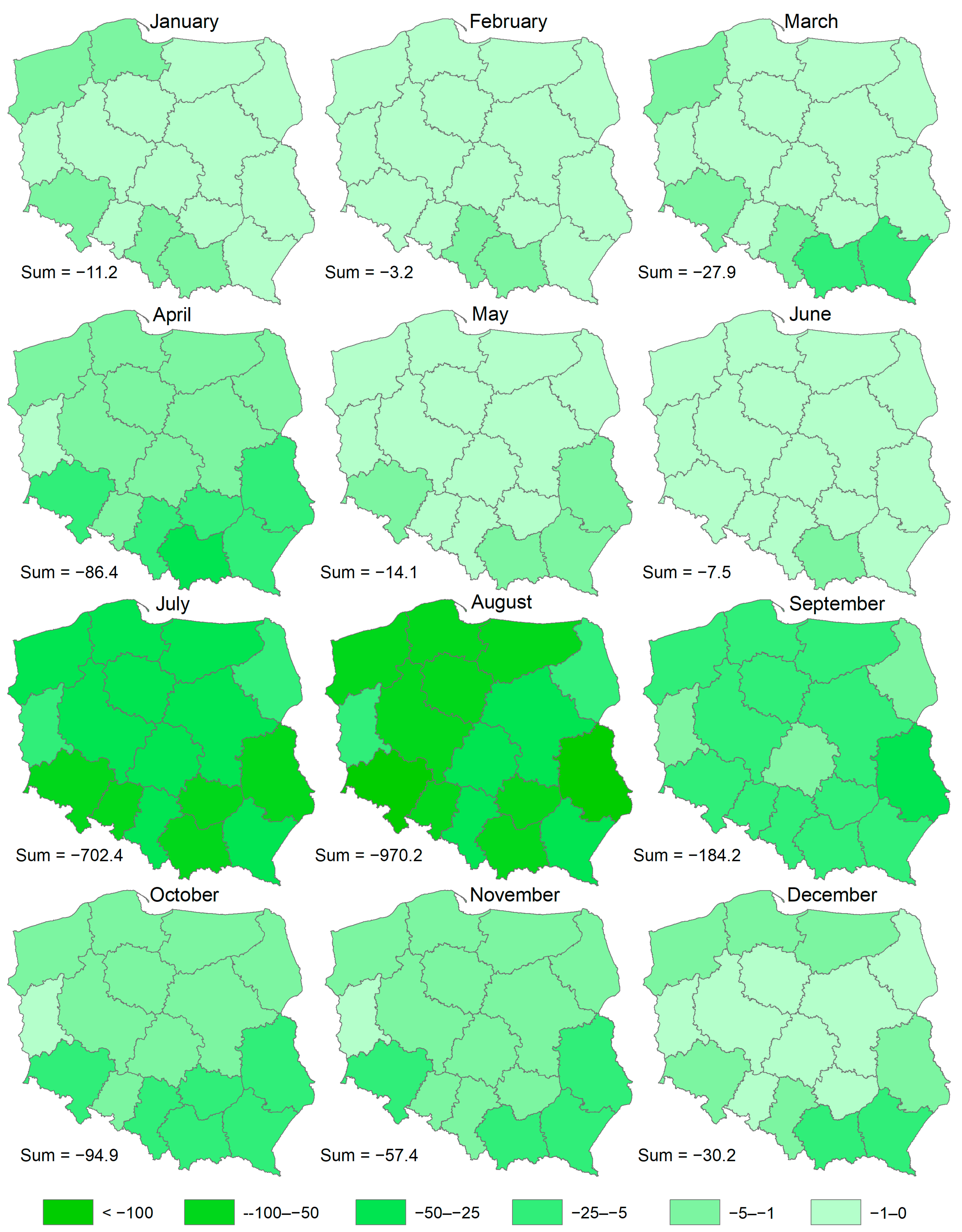
| Voivodeship | Jan | Feb | Mar | Apr | May | Jun | Jul | Aug | Sep | Oct | Nov | Dec | Total |
|---|---|---|---|---|---|---|---|---|---|---|---|---|---|
| Śląskie | −1.6 | −1.1 | −4.5 | −6.4 | −0.9 | −0.5 | −32.7 | −41.3 | −8.8 | −5.0 | −4.3 | −2.2 | −109 |
| Opolskie | 0.0 | 0.0 | −0.3 | −1.9 | −0.5 | −0.2 | −58.9 | −72.1 | −14.5 | −4.4 | −2.0 | −0.3 | −155 |
| Wielkopolskie | −0.4 | 0.0 | −0.2 | −1.3 | −0.3 | −0.3 | −49.7 | −52.6 | −7.5 | −2.8 | −1.5 | −0.8 | −117 |
| Zachodniopomorskie | −2.0 | −0.2 | −1.5 | −2.1 | −0.4 | −0.3 | −36.1 | −51.3 | −7.5 | −3.4 | −1.9 | −2.6 | −109 |
| Świętokrzyskie | 0.0 | 0.0 | −0.1 | −5.7 | −0.9 | −0.4 | −52.7 | −70.3 | −13.5 | −6.7 | −3.3 | −0.3 | −154 |
| Kujawsko-pomorskie | 0.0 | 0.0 | 0.0 | −1.7 | −0.5 | −0.3 | −43.0 | −55.9 | −8.3 | −3.3 | −1.9 | −0.8 | −116 |
| Podlaskie | 0.0 | 0.0 | 0.0 | −1.9 | −0.3 | −0.2 | −10.0 | −18.7 | −3.7 | −2.2 | −1.4 | −0.4 | −39 |
| Dolnośląskie | −2.4 | −0.3 | −3.1 | −7.5 | −1.4 | −0.7 | −91.2 | −114.2 | −19.7 | −9.7 | −5.4 | −2.7 | −258 |
| Podkarpackie | −0.1 | −0.1 | −5.8 | −14.0 | −1.9 | −1.0 | −35.1 | −45.2 | −14.0 | −11.7 | −7.2 | −6.4 | −143 |
| Małopolskie | −2.6 | −1.0 | −11.3 | −25.1 | −3.0 | −2.1 | −67.4 | −96.7 | −22.6 | −17.2 | −12.3 | −6.2 | −268 |
| Pomorskie | −1.0 | 0.0 | −0.2 | −2.3 | −0.8 | −0.4 | −27.7 | −50.8 | −8.5 | −4.5 | −2.9 | −2.3 | −101 |
| Warmińsko-mazurskie | −0.8 | −0.4 | −0.6 | −3.2 | −0.7 | −0.4 | −26.9 | −56.2 | −9.4 | −4.7 | −4.1 | −2.0 | −109 |
| Łódzkie | 0.0 | 0.0 | 0.0 | −1.3 | −0.1 | −0.1 | −32.1 | −34.1 | −4.7 | −1.9 | −1.5 | −0.3 | −76 |
| Mazowieckie | 0.0 | 0.0 | 0.0 | −1.8 | −0.2 | −0.2 | −27.7 | −36.3 | −5.7 | −2.4 | −1.6 | −0.4 | −76 |
| Lubelskie | 0.0 | 0.0 | 0.0 | −9.9 | −2.0 | −0.4 | −95.3 | −159.4 | −33.5 | −14.2 | −5.5 | −2.0 | −322 |
| Lubuskie | −0.4 | −0.1 | −0.3 | −0.5 | −0.1 | −0.1 | −15.8 | −15.4 | −2.2 | −0.9 | −0.4 | −0.5 | −37 |
| Total | −11.3 | −3.3 | −27.9 | −86.4 | −14.1 | −7.6 | −702.4 | −970.2 | −184.2 | −95.0 | −57.4 | −30.3 | −2190 |
Disclaimer/Publisher’s Note: The statements, opinions and data contained in all publications are solely those of the individual author(s) and contributor(s) and not of MDPI and/or the editor(s). MDPI and/or the editor(s) disclaim responsibility for any injury to people or property resulting from any ideas, methods, instructions or products referred to in the content. |
© 2025 by the author. Licensee MDPI, Basel, Switzerland. This article is an open access article distributed under the terms and conditions of the Creative Commons Attribution (CC BY) license (https://creativecommons.org/licenses/by/4.0/).
Share and Cite
Marcinkowski, P. Unveiling the Potential of Agricultural Soil Loss Mitigation in Poland: Assessing Conservation Management and Support Practices. Agronomy 2025, 15, 1290. https://doi.org/10.3390/agronomy15061290
Marcinkowski P. Unveiling the Potential of Agricultural Soil Loss Mitigation in Poland: Assessing Conservation Management and Support Practices. Agronomy. 2025; 15(6):1290. https://doi.org/10.3390/agronomy15061290
Chicago/Turabian StyleMarcinkowski, Paweł. 2025. "Unveiling the Potential of Agricultural Soil Loss Mitigation in Poland: Assessing Conservation Management and Support Practices" Agronomy 15, no. 6: 1290. https://doi.org/10.3390/agronomy15061290
APA StyleMarcinkowski, P. (2025). Unveiling the Potential of Agricultural Soil Loss Mitigation in Poland: Assessing Conservation Management and Support Practices. Agronomy, 15(6), 1290. https://doi.org/10.3390/agronomy15061290