Using Constrained K-Means Clustering for Soil Texture Mapping with Limited Soil Samples


Abstract
1. Introduction
2. Materials and Methods
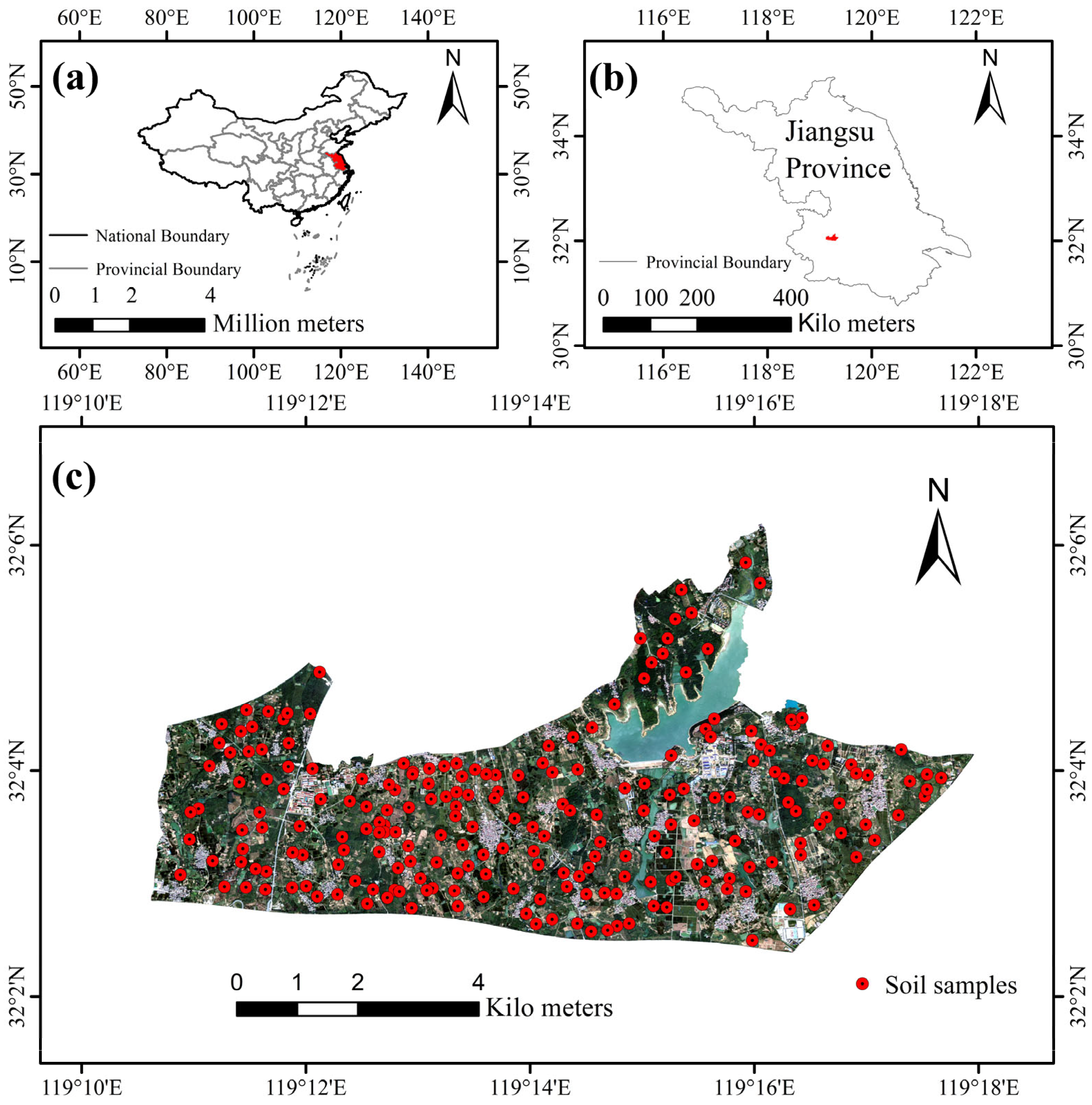
2.1. Study Area
2.2. Soil Data
2.3. Environmental Variables Data
2.3.1. Remote Sensing Data
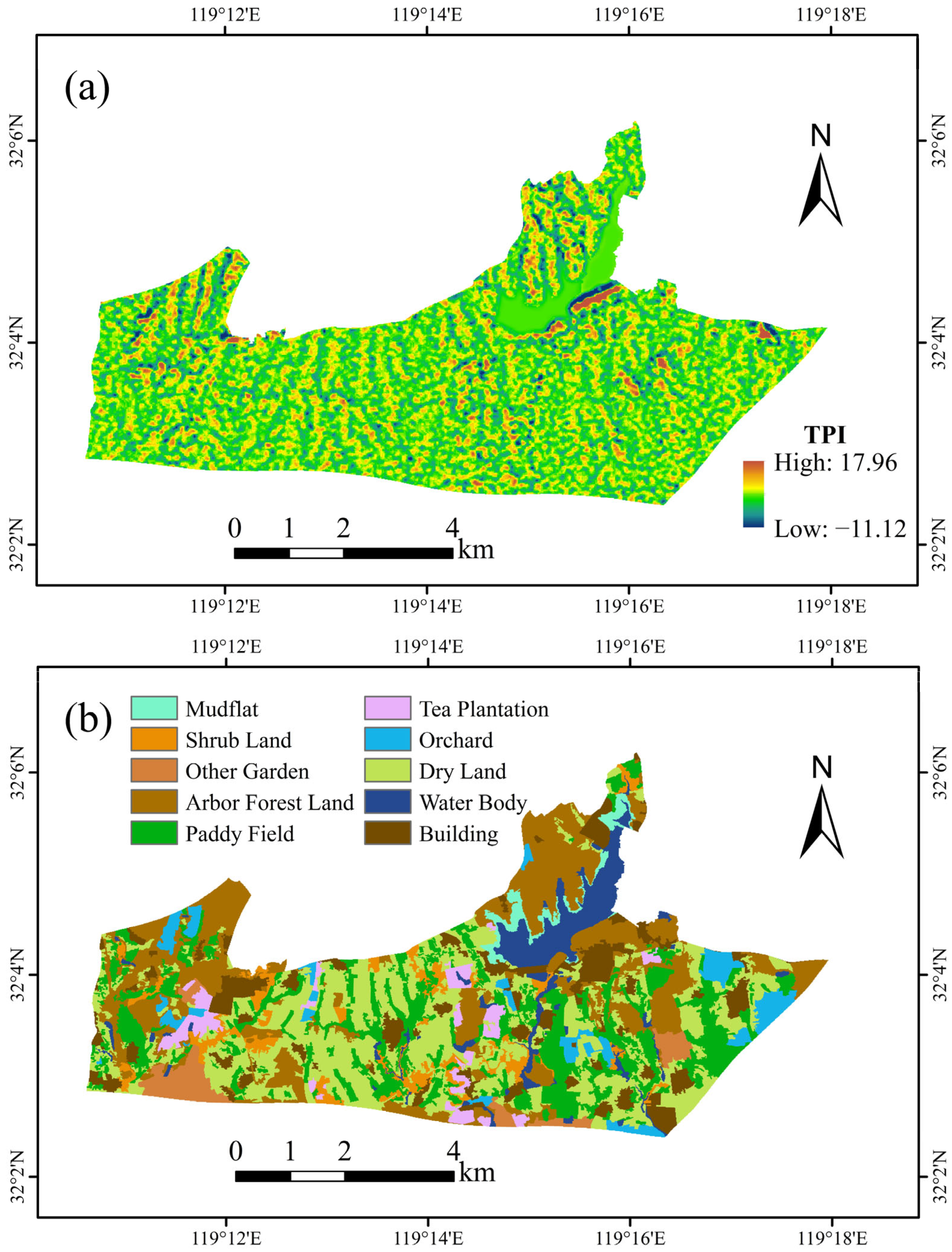
2.3.2. Terrain Data
2.4. Data Preprocessing
2.5. Soil Texture Prediction Models
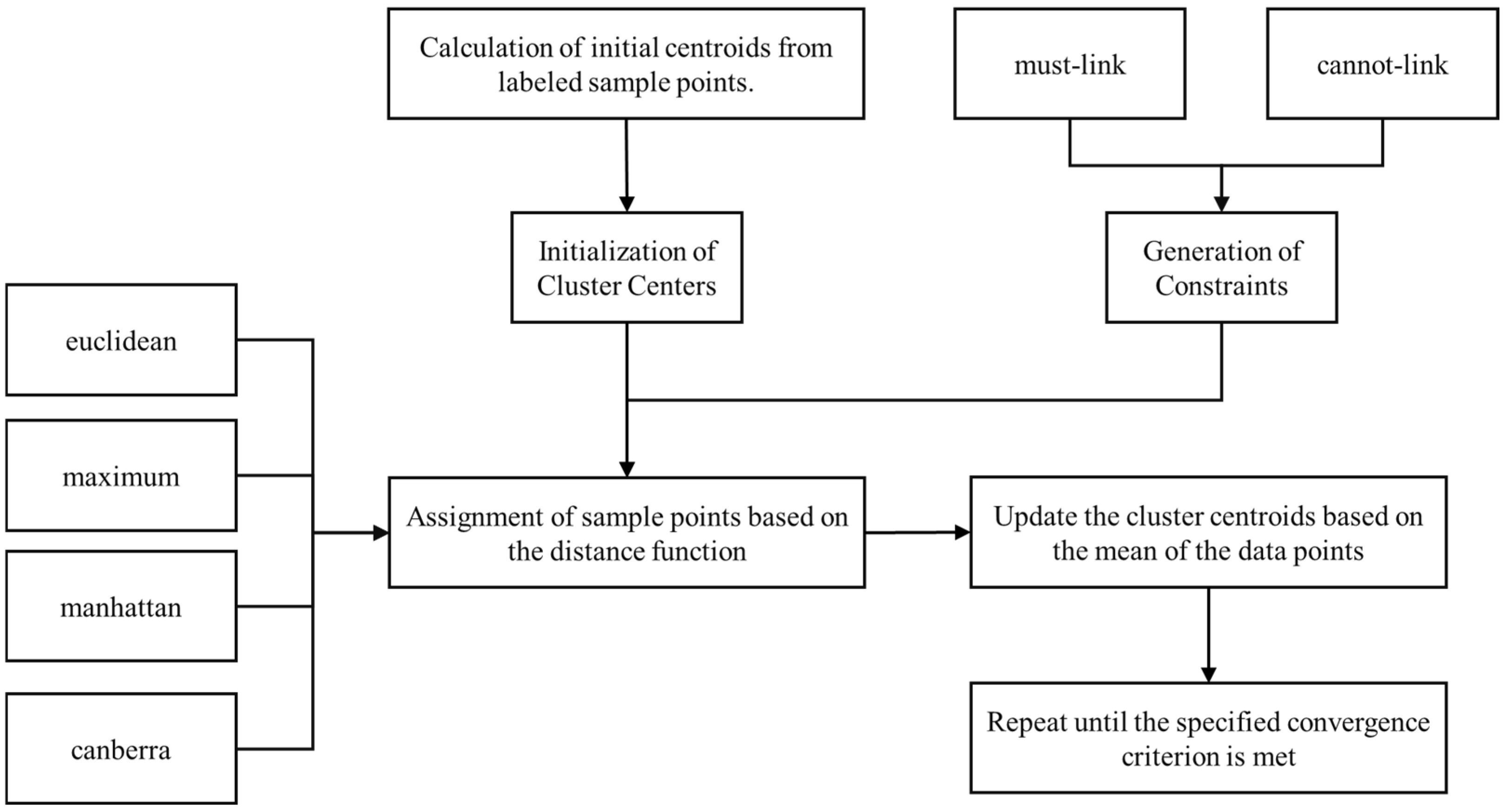
2.5.1. Constrained K-Means Clustering
- Initialization of Cluster Centers: For each cluster, the initial center is computed as the mean of the feature vectors of all labeled data points within that category. For instance, when initializing the cluster center for the soil texture type “Loam”, the mean values of the environmental variables for all corresponding labeled samples are calculated to establish the center.
- Generation of Constraints: Constraint information is derived from the labeled data, encompassing both must-link and cannot-link constraints. A must-link constraint indicates that two data points must belong to the same cluster, whereas a cannot-link constraint requires that they belong to different clusters. Specifically, for each soil texture class, a must-link constraint is created between every pair of labeled samples within that class to ensure they are assigned to the same cluster during the clustering process. Conversely, cannot-link constraints are imposed between labeled samples of different classes to guarantee they are assigned to different clusters. For example, if two soil samples are both classified as Loam, they form a must-link pair; conversely, if one sample is classified as Loam and the other as Silty Loam, they form a cannot-link pair. By analogy, must-link constraints and cannot-link constraints were established for all soil sample points.
- Assignment of Data Points: For each unlabeled sample, the distance to every cluster center is calculated, and the sample is assigned to the cluster corresponding to the nearest center. In contrast, the cluster assignments of labeled samples remain unchanged due to the imposed constraints. At this stage, the distance function is a crucial parameter, and its selection can significantly affect the final assignment outcomes. In contrast to conventional supervised classification methods that rely solely on labeled data to build the model, this approach fully exploits a small number of labeled samples in conjunction with a large volume of unlabeled data. In essence, the few labeled samples serve to guide the clustering of the abundant unlabeled samples, ultimately achieving effective classification.
- Updating Cluster Centers: For each cluster, the center is recalculated by computing the mean of all data points within that cluster. The clustering assignments of labeled samples remain fixed due to the constraint information, whereas the assignments for unlabeled samples are continuously updated in subsequent iterations.
- Iterative Optimization: Repeat steps 3 and 4 until the cluster centers no longer change or the maximum number of iterations is reached. In this study, to compare the effect of key parameters (distance method) in Constrained K-Means Clustering, we selected the default number of iterations (i.e., 10 iterations) for each distance method.
2.5.2. Random Forest (RF)
2.5.3. Multilayer Perceptron (MLP)
2.6. Assessment of Model Performance
2.7. Analysis of Environmental Variable Importance
3. Results
3.1. Descriptive Statistics of Soil Texture Distribution
3.2. Model Predictive Performance
3.3. Spatial Distribution of Soil Texture
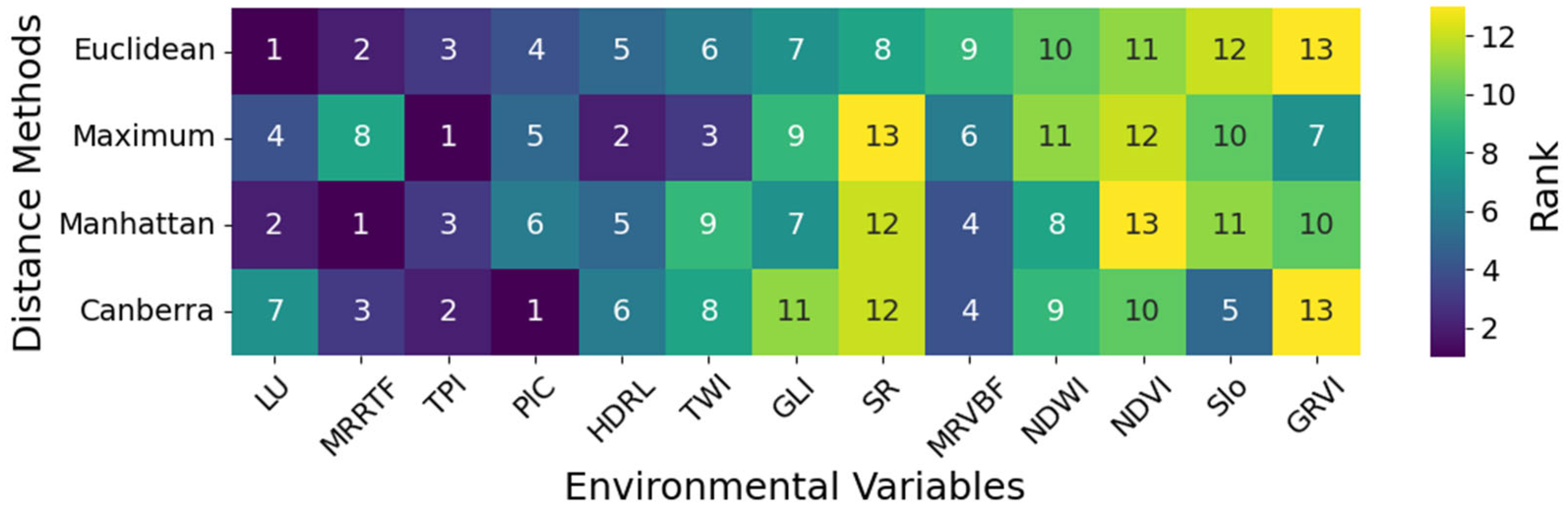
3.4. Importance Analysis of Environmental Variables
4. Discussion
5. Conclusions
Author Contributions
Funding
Data Availability Statement
Conflicts of Interest
References
- Zheng, M.; Wang, X.; Li, S.; Zhu, B.; Hou, J.; Song, K. Soil Texture Mapping in Songnen Plain of China Using Sentinel-2 Imagery. Remote Sens. 2023, 15, 5351. [Google Scholar] [CrossRef]
- Mallah, S.; Delsouz Khaki, B.; Davatgar, N.; Scholten, T.; Amirian-Chakan, A.; Emadi, M.; Kerry, R.; Mosavi, A.H.; Taghizadeh-Mehrjardi, R. Predicting Soil Textural Classes Using Random Forest Models: Learning from Imbalanced Dataset. Agronomy 2022, 12, 2613. [Google Scholar] [CrossRef]
- Prakash, R.; Singh, D.; Pathak, N.P. Microwave Specular Scattering Response of Soil Texture at X-Band. Adv. Space Res. 2009, 44, 801–814. [Google Scholar] [CrossRef]
- Rajput, U.; Sharma, S.; Swami, D.; Joshi, N. Rapid Assessment of Soil–Water Retention Using Soil Texture-Based Models. Environ. Earth Sci. 2024, 83, 454. [Google Scholar] [CrossRef]
- Silver, W.L.; Neff, J.; McGroddy, M.; Veldkamp, E.; Keller, M.; Cosme, R. Effects of Soil Texture on Belowground Carbon and Nutrient Storage in a Lowland Amazonian Forest Ecosystem. Ecosystems 2000, 3, 193–209. [Google Scholar] [CrossRef]
- Jiang, L.; Liu, H.; Peng, Z.; Dai, J.; Zhao, F.; Chen, Z. Root System Plays an Important Role in Responses of Plant to Drought in the Steppe of China. Land Degrad. Dev. 2021, 32, 3498–3506. [Google Scholar] [CrossRef]
- Zhao, Z.; Feng, W.; Xiao, J.; Liu, X.; Pan, S.; Liang, Z. Rapid and Accurate Prediction of Soil Texture Using an Image-Based Deep Learning Autoencoder Convolutional Neural Network Random Forest (DLAC-CNN-RF) Algorithm. Agronomy 2022, 12, 3063. [Google Scholar] [CrossRef]
- Fan, Y.; Yin, W.; Yang, Z.; Wang, Y.; Ma, L. Moisture Content Distribution Model for the Soil Wetting Body under Moistube Irrigation. Water SA 2023, 49, 73–91. [Google Scholar]
- Ye, C.; Zheng, G.; Tao, Y.; Xu, Y.; Chu, G.; Xu, C.; Chen, S.; Liu, Y.; Zhang, X.; Wang, D. Effect of Soil Texture on Soil Nutrient Status and Rice Nutrient Absorption in Paddy Soils. Agronomy 2024, 14, 1339. [Google Scholar] [CrossRef]
- Fatima, B.; Rachid, H.; Khalil, E.K.; Abdessalam, O.; Abdeldjalil, B.; Mohamed, B.; Tariq, A.; Davis, B.J., Jr.; Soufan, W. Modelling, Quantification and Estimation of the Soil Water Erosion Using the Revised Universal Soil Loss Equation with Sediment Delivery Ratio and the Analytic Hierarchy Process Models. Earth Surf. Process. Landf. 2024, 49, 3158–3176. [Google Scholar] [CrossRef]
- Tolera, A.M.; Haile, M.M.; Merga, T.F.; Feyisa, G.A. Assessment of Land Suitability for Irrigation in West Shewa Zone, Oromia, Ethiopia. Appl. Water Sci. 2023, 13, 112. [Google Scholar] [CrossRef]
- Tosini, L.; Folzer, H.; Heckenroth, A.; Prudent, P.; Santonja, M.; Farnet, A.-M.; Salducci, M.-D.; Vassalo, L.; Labrousse, Y.; Oursel, B.; et al. Gain in Biodiversity but Not in Phytostabilization after 3 Years of Ecological Restoration of Contaminated Mediterranean Soils. Ecol. Eng. 2020, 157, 105998. [Google Scholar] [CrossRef]
- Li, Y.; Wang, L.; Yu, Y.; Zang, D.; Dai, X.; Zheng, S. Cropland Zoning Based on District and County Scales in the Black Soil Region of Northeastern China. Sustainability 2024, 16, 3341. [Google Scholar] [CrossRef]
- Feng, L.; Khalil, U.; Aslam, B.; Ghaffar, B.; Tariq, A.; Jamil, A.; Farhan, M.; Aslam, M.; Soufan, W. Evaluation of Soil Texture Classification from Orthodox Interpolation and Machine Learning Techniques. Environ. Res. 2024, 246, 118075. [Google Scholar] [CrossRef]
- Li, J.; Wan, H.; Shang, S. Comparison of Interpolation Methods for Mapping Layered Soil Particle-Size Fractions and Texture in an Arid Oasis. Catena 2020, 190, 104514. [Google Scholar] [CrossRef]
- Piikki, K.; Söderström, M. Digital Soil Mapping of Arable Land in Sweden—Validation of Performance at Multiple Scales. Geoderma 2019, 352, 342–350. [Google Scholar] [CrossRef]
- Saygın, F.; Aksoy, H.; Alaboz, P.; Dengiz, O. Different Approaches to Estimating Soil Properties for Digital Soil Map Integrated with Machine Learning and Remote Sensing Techniques in a Sub-Humid Ecosystem. Environ. Monit. Assess. 2023, 195, 1061. [Google Scholar] [CrossRef]
- Ngu, N.H.; Thanh, N.N.; Duc, T.T.; Non, D.Q.; Thuy An, N.T.; Chotpantarat, S. Active Learning-Based Random Forest Algorithm Used for Soil Texture Classification Mapping in Central Vietnam. Catena 2024, 234, 107629. [Google Scholar] [CrossRef]
- Silva, S.H.G.; Weindorf, D.C.; Pinto, L.C.; Faria, W.M.; Acerbi, F.W., Jr.; Gomide, L.R.; de Mello, J.M.; de Pádua, A.L., Jr.; Souza, I.A.; Teixeira, A.F.D.S.; et al. Soil Texture Prediction in Tropical Soils: A Portable X-Ray Fluorescence Spectrometry Approach. Geoderma 2020, 362, 114136. [Google Scholar] [CrossRef]
- Yousif, B.S.; Mustafa, Y.T.; Fayyadh, M.A. Digital Mapping of Soil-Texture Classes in Batifa, Kurdistan Region of Iraq, Using Machine-Learning Models. Earth Sci. Inform. 2023, 16, 1687–1700. [Google Scholar] [CrossRef]
- Omondiagbe, O.P.; Lilburne, L.; Licorish, S.A.; MacDonell, S.G. Soil Texture Prediction with Automated Deep Convolutional Neural Networks and Population-Based Learning. Geoderma 2023, 436, 116521. [Google Scholar] [CrossRef]
- Coblinski, J.A.; Giasson, É.; Demattê, J.A.M.; Dotto, A.C.; Costa, J.J.F.; Vašát, R. Prediction of Soil Texture Classes through Different Wavelength Regions of Reflectance Spectroscopy at Various Soil Depths. Catena 2020, 189, 104485. [Google Scholar] [CrossRef]
- Kim, J.; Lee, Y.; Lee, M.-H.; Hong, S.-Y. A Comparative Study of Machine Learning and Spatial Interpolation Methods for Predicting House Prices. Sustainability 2022, 14, 9056. [Google Scholar] [CrossRef]
- Cai, J.; Hao, J.; Yang, H.; Zhao, X.; Yang, Y. A Review on Semi-Supervised Clustering. Inf. Sci. 2023, 632, 164–200. [Google Scholar] [CrossRef]
- Du, F.; Zhu, A.; Liu, J.; Yang, L. Predictive Mapping with Small Field Sample Data Using Semi-supervised Machine Learning. Trans. GIS 2020, 24, 315–331. [Google Scholar] [CrossRef]
- Zhang, L.; Yang, L.; Ma, T.; Shen, F.; Cai, Y.; Zhou, C. A Self-Training Semi-Supervised Machine Learning Method for Predictive Mapping of Soil Classes with Limited Sample Data. Geoderma 2021, 384, 114809. [Google Scholar] [CrossRef]
- Trung, N.T.; Le, X.-H.; Tuan, T.M. Enhancing Contrast of Dark Satellite Images Based on Fuzzy Semi-Supervised Clustering and an Enhancement Operator. Remote Sens. 2023, 15, 1645. [Google Scholar] [CrossRef]
- Roy, P.; Kislay, A.; Plonski, P.A.; Luby, J.; Isler, V. Vision-Based Preharvest Yield Mapping for Apple Orchards. Comput. Electron. Agric. 2019, 164, 104897. [Google Scholar] [CrossRef]
- He, W.; Xiao, Z.; Lu, Q.; Wei, L.; Liu, X. Digital Mapping of Soil Particle Size Fractions in the Loess Plateau, China, Using Environmental Variables and Multivariate Random Forest. Remote Sens. 2024, 16, 785. [Google Scholar] [CrossRef]
- Wang, R.; Chen, W.; Chen, H.; Qin, X. Finer Soil Properties Mapping Framework for Broad-Scale Area: A Case Study of Hubei Province, China. Geoderma 2024, 449, 117023. [Google Scholar] [CrossRef]
- Zhou, Y.; Wu, W.; Liu, H. Exploring the Influencing Factors in Identifying Soil Texture Classes Using Multitemporal Landsat-8 and Sentinel-2 Data. Remote Sens. 2022, 14, 5571. [Google Scholar] [CrossRef]
- Saurette, D.D. Comparing Direct and Indirect Approaches to Predicting Soil Texture Class. Can. J. Soil. Sci. 2022, 102, 835–851. [Google Scholar] [CrossRef]
- Fang, Z.H. Landscape Classification System Based on UAV Images for Soil Survey–A Study Case in Northern of Jurong City. Master’s Thesis, Nanjing Agricultural University, Nanjing, China, 2023. [Google Scholar]
- Zhu, C.; Zhu, F.; Li, C.; Lu, W.; Fang, Z.; Li, Z.; Pan, J. Constructing Soil–Landscape Units Based on Slope Position and Land Use to Improve Soil Prediction Accuracy. Remote Sens. 2024, 16, 4090. [Google Scholar] [CrossRef]
- Zhu, F.; Zhu, C.; Lu, W.; Fang, Z.; Li, Z.; Pan, J. Soil Classification Mapping Using a Combination of Semi-Supervised Classification and Stacking Learning (SSC-SL). Remote Sens. 2024, 16, 405. [Google Scholar] [CrossRef]
- Jenny, H. Factors of Soil Formation: A System of Quantitative Pedology; McGraw-Hill: New York, NY, USA, 1941. [Google Scholar]
- Mirzaeitalarposhti, R.; Shafizadeh-Moghadam, H.; Taghizadeh-Mehrjardi, R.; Demyan, M.S. Digital Soil Texture Mapping and Spatial Transferability of Machine Learning Models Using Sentinel-1, Sentinel-2, and Terrain-Derived Covariates. Remote Sens. 2022, 14, 5909. [Google Scholar] [CrossRef]
- Yüzügüllü, O.; Fajraoui, N.; Liebisch, F. Soil Texture and pH Mapping Using Remote Sensing and Support Sampling. IEEE J. Sel. Top. Appl. Earth Observ. Remote Sens. 2024, 17, 12685–12705. [Google Scholar] [CrossRef]
- Li, Y.; Wang, C.; Wright, A.; Liu, H.; Zhang, H.; Zong, Y. Combination of GF-2 High Spatial Resolution Imagery and Land Surface Factors for Predicting Soil Salinity of Muddy Coasts. Catena 2021, 202, 105304. [Google Scholar] [CrossRef]
- Han, D.; Cao, Y.; Yang, F.; Zhang, X.; Yang, M. Water Quality Estimation Using Gaofen-2 Images Based on UAV Multispectral Data Modeling in Qinba Rugged Terrain Area. Water 2024, 16, 732. [Google Scholar] [CrossRef]
- Tucker, C.J. Red and Photographic Infrared Linear Combinations for Monitoring Vegetation. Remote Sens. Environ. 1979, 8, 127–150. [Google Scholar] [CrossRef]
- Kaya, F.; Başayiğit, L.; Keshavarzi, A.; Francaviglia, R. Digital Mapping for Soil Texture Class Prediction in Northwestern Türkiye by Different Machine Learning Algorithms. Geoderma Reg. 2022, 31, e00584. [Google Scholar] [CrossRef]
- Louhaichi, M.; Borman, M.M.; Johnson, D.E. Spatially Located Platform and Aerial Photography for Documentation of Grazing Impacts on Wheat. Geocarto Int. 2001, 16, 65–70. [Google Scholar] [CrossRef]
- Sripada, R.P.; Heiniger, R.W.; White, J.G.; Meijer, A.D. Aerial Color Infrared Photography for Determining Early In-Season Nitrogen Requirements in Corn. Agron. J. 2006, 98, 968–977. [Google Scholar] [CrossRef]
- Buruso, F.H.; Adimassu, Z.; Sibali, L.L. Effects of Land Use/Land Cover Changes on Soil Properties in Rib Watershed, Ethiopia. Catena 2023, 224, 106977. [Google Scholar] [CrossRef]
- Rouse, J.W.; Haas, R.H.; Schell, J.A.; Deering, D.W. Monitoring Vegetation Systems in the Great Plains with ERTS; Scientific and Technical Information Office, National Aeronautics and Space Administration: Hampton, VA, USA, 1974. [Google Scholar]
- McFeeters, S.K. The use of the Normalized Difference Water Index (NDWI) in the delineation of open water features. Int. J. Remote Sens. 1996, 17, 1425–1432. [Google Scholar] [CrossRef]
- Jordan, C.F. Derivation of Leaf-Area Index from Quality of Light on the Forest Floor. Ecology 1969, 50, 663–666. [Google Scholar] [CrossRef]
- Mirghaed, F.A.; Souri, B. Contribution of Land Use, Soil Properties and Topographic Features for Providing of Ecosystem Services. Ecol. Eng. 2023, 189, 106898. [Google Scholar] [CrossRef]
- Iwashita, F.; Friedel, M.J.; Ribeiro, G.F.; Fraser, S.J. Intelligent Estimation of Spatially Distributed Soil Physical Properties. Geoderma 2012, 170, 1–10. [Google Scholar] [CrossRef]
- Zevenbergen, L.W.; Thorne, C.R. Quantitative analysis of land surface topography. Earth Surf. Process. Landf. 1987, 12, 47–56. [Google Scholar] [CrossRef]
- Gallant, J.C.; Dowling, T.I. A multiresolution index of valley bottom flatness for mapping depositional areas. Water Resour. Res. 2003, 39, 291–297. [Google Scholar] [CrossRef]
- Guisan, A.; Weiss, S.B.; Weiss, A.D. GLM versus CCA spatial modeling of plant species distribution. Plant Ecol. 1999, 143, 107–122. [Google Scholar] [CrossRef]
- Beven, K.J.; Kirkby, M.J. A physically based, variable contributing area model of basin hydrology. Hydrol. Sci. Bull. 1979, 24, 43–69. [Google Scholar] [CrossRef]
- Munaganuri, R.K.; Rao, Y.N. Cap-DiBiL: An Automated Model for Crop Water Requirement Prediction and Suitable Crop Recommendation in Agriculture. Environ. Res. Commun. 2023, 5, 095016. [Google Scholar] [CrossRef]
- Kuhn, M. Caret: Classification and Regression Training. R Package Version 6.0-92. Available online: https://CRAN.R-project.org/package=caret (accessed on 10 May 2025).
- Bonfante, M.C.; Montes, J.C.; Pino, M.; Ruiz, R.; González, G. Machine Learning Applications to Identify Young Offenders Using Data from Cognitive Function Tests. Data 2023, 8, 174. [Google Scholar] [CrossRef]
- Baciu, C.; Ghosh, S.; Naimimohasses, S.; Rahmani, A.; Pasini, E.; Naghibzadeh, M.; Azhie, A.; Bhat, M. Harnessing Metabolites as Serum Biomarkers for Liver Graft Pathology Prediction Using Machine Learning. Metabolites 2024, 14, 254. [Google Scholar] [CrossRef]
- Jia, C.; Guo, L.; Liao, K.; Lu, Z. Efficient Algorithm for the k-Means Problem with Must-Link and Cannot-Link Constraints. Tsinghua Sci. Technol. 2023, 28, 1050–1062. [Google Scholar] [CrossRef]
- Golzari Oskouei, A.; Samadi, N.; Tanha, J. Feature-Weight and Cluster-Weight Learning in Fuzzy c-Means Method for Semi-Supervised Clustering. Appl. Soft Comput. 2024, 161, 111712. [Google Scholar] [CrossRef]
- Basu, S.; Banerjee, A.; Mooney, R.J. Semi-supervised Clustering by Seeding. In Proceedings of the 19th International Conference on Machine Learning (ICML-2002), Sydney, Australia, July 2002. [Google Scholar]
- Yao, G.; Wu, Y.; Huang, X.; Ma, Q.; Du, J. Clustering of Typical Wind Power Scenarios Based on K-Means Clustering Algorithm and Improved Artificial Bee Colony Algorithm. IEEE Access 2022, 10, 98752–98760. [Google Scholar] [CrossRef]
- Zhao, X.; Nie, F.; Wang, R.; Li, X. Improving Projected Fuzzy K-Means Clustering via Robust Learning. Neurocomputing 2022, 491, 34–43. [Google Scholar] [CrossRef]
- Liu, H.; Chen, J.; Dy, J.; Fu, Y. Transforming Complex Problems into K-Means Solutions. IEEE Trans. Pattern Anal. Mach. Intell. 2023, 45, 9149–9168. [Google Scholar] [CrossRef]
- Mei, Y.; Tang, K.; Li, K. Real-Time Identification of Probe Vehicle Trajectories in the Mixed Traffic Corridor. Transp. Res. Part C Emerg. Technol. 2015, 57, 55–67. [Google Scholar] [CrossRef]
- Breiman, L. Random Forests. Mach. Learn. 2001, 45, 5–32. [Google Scholar] [CrossRef]
- Zeraatpisheh, M.; Ayoubi, S.; Jafari, A.; Finke, P. Comparing the Efficiency of Digital and Conventional Soil Mapping to Predict Soil Types in a Semi-Arid Region in Iran. Geomorphology 2017, 285, 186–204. [Google Scholar] [CrossRef]
- Siqueira, R.G.; Moquedace, C.M.; Francelino, M.R.; Schaefer, C.E.G.R.; Fernandes-Filho, E.I. Machine Learning Applied for Antarctic Soil Mapping: Spatial Prediction of Soil Texture for Maritime Antarctica and Northern Antarctic Peninsula. Geoderma 2023, 432, 116405. [Google Scholar] [CrossRef]
- Azizi, K.; Garosi, Y.; Ayoubi, S.; Tajik, S. Integration of Sentinel-1/2 and Topographic Attributes to Predict the Spatial Distribution of Soil Texture Fractions in Some Agricultural Soils of Western Iran. Soil Tillage Res. 2023, 229, 105681. [Google Scholar] [CrossRef]
- Oppong Sarkodie, V.Y.; Vašát, R.; Pouladi, N.; Šrámek, V.; Sáňka, M.; Fadrhonsová, V.; Hellebrandová, K.N.; Borůvka, L. Predicting Soil Organic Carbon Stocks in Different Layers of Forest Soils in the Czech Republic. Geoderma Reg. 2023, 34, e00658. [Google Scholar] [CrossRef]
- Pusch, M.; Samuel-Rosa, A.; Sergio Graziano Magalhães, P.; Rios Do Amaral, L. Covariates in Sample Planning Optimization for Digital Soil Fertility Mapping in Agricultural Areas. Geoderma 2023, 429, 116252. [Google Scholar] [CrossRef]
- Xiao, S.; Ou, M.; Geng, Y.; Zhou, T. Mapping Soil pH Levels across Europe: An Analysis of LUCAS Topsoil Data Using Random Forest Kriging (RFK). Soil Use Manag. 2023, 39, 900–916. [Google Scholar] [CrossRef]
- Rumelhart, D.E.; Hinton, G.E.; Williams, R.J. Learning Internal Representations by Error Propagation. In Parallel Distributed Processing: Explorations in the Microstructure of Cognition, Volume 1: Foundations; Rumelhart, D.E., Mcclelland, J.L., Eds.; MIT Press: Cambridge, MA, USA, 1986; pp. 318–362. [Google Scholar]
- He, X.; Chen, Y. Modifications of the Multi-Layer Perceptron for Hyperspectral Image Classification. Remote Sens. 2021, 13, 3547. [Google Scholar] [CrossRef]
- Chen, S.; Xu, D.; Li, S.; Ji, W.; Yang, M.; Zhou, Y.; Hu, B.; Xu, H.; Shi, Z. Monitoring Soil Organic Carbon in Alpine Soils Using in Situ vis-NIR Spectroscopy and a Multilayer Perceptron. Land Degrad. Dev. 2020, 31, 1026–1038. [Google Scholar] [CrossRef]
- Valavi, R.; Elith, J.; Lahoz-Monfort, J.J.; Flint, I.; Guillera-Arroita, G. blockCV: Spatial and Environmental Blocking for K-Fold and LOO Cross-Validation, R Package Version 2.3.4; CRAN. Available online: https://cran.r-project.org/package=blockCV (accessed on 10 May 2025).
- Wu, W.; Li, A.-D.; He, X.-H.; Ma, R.; Liu, H.-B.; Lv, J.-K. A Comparison of Support Vector Machines, Artificial Neural Network and Classification Tree for Identifying Soil Texture Classes in Southwest China. Computers and Electronics in Agriculture 2018, 144, 86–93. [Google Scholar] [CrossRef]
- Wu, W.; Yang, Q.; Lv, J.; Li, A.; Liu, H. Investigation of Remote Sensing Imageries for Identifying Soil Texture Classes Using Classification Methods. IEEE Trans. Geosci. Remote Sens. 2019, 57, 1653–1663. [Google Scholar] [CrossRef]
- Hong, Y.; Li, D.; Wang, M.; Jiang, H.; Luo, L.; Wu, Y.; Liu, C.; Xie, T.; Zhang, Q.; Jahangir, Z. Cotton Cultivated Area Extraction Based on Multi-Feature Combination and CSSDI under Spatial Constraint. Remote Sens. 2022, 14, 1392. [Google Scholar] [CrossRef]
- Rousseeuw, P.J. Silhouettes: A Graphical Aid to the Interpretation and Validation of Cluster Analysis. J. Comput. Appl. Math. 1987, 20, 53–65. [Google Scholar] [CrossRef]
- Sotomayor, L.N.; Cracknell, M.J.; Musk, R. Supervised Machine Learning for Predicting and Interpreting Dynamic Drivers of Plantation Forest Productivity in Northern Tasmania, Australia. Comput. Electron. Agric. 2023, 209, 107804. [Google Scholar] [CrossRef]
- Ozsagir, M.; Erden, C.; Bol, E.; Sert, S.; Özocak, A. Machine Learning Approaches for Prediction of Fine-Grained Soils Liquefaction. Comput. Geotech. 2022, 152, 105014. [Google Scholar] [CrossRef]
- Sarkar, S.; Ghosh, A.K. On Perfect Clustering of High Dimension, Low Sample Size Data. IEEE Trans. Pattern Anal. Mach. Intell. 2020, 42, 2257–2272. [Google Scholar] [CrossRef]
- Shi, G.; Shangguan, W.; Zhang, Y.; Li, Q.; Wang, C.; Li, L. Reducing Location Error of Legacy Soil Profiles Leads to Improvement in Digital Soil Mapping. Geoderma 2024, 447, 116912. [Google Scholar] [CrossRef]
- Liu, Q.; He, L.; Guo, L.; Wang, M.; Deng, D.; Lv, P.; Wang, R.; Jia, Z.; Hu, Z.; Wu, G.; et al. Digital Mapping of Soil34on Density Using Newly Developed Bare Soil Spectral Indices and Deep Neural Network. Catena 2022, 219, 106603. [Google Scholar] [CrossRef]
- Zhou, Y.; Wu, W.; Wang, H.; Zhang, X.; Yang, C.; Liu, H. Identification of Soil Texture Classes Under Vegetation Cover Based on Sentinel-2 Data with SVM and SHAP Techniques. IEEE J. Sel. Top. Appl. Earth Obs. Remote Sens. 2022, 15, 3758–3770. [Google Scholar] [CrossRef]


| Name of Environmental Variables/Definition | Abbreviation | Reference | |
|---|---|---|---|
| Remote Sensing Data | Green Leaf Index | GLI | [43] |
| ((2 × G − B − R)/(2 × G + B + R)) | |||
| Green Ratio Vegetation Index (NIR/G) | GRVI | [44] | |
| Land Use | LU | [45] | |
| Normalized Difference Vegetation Index | NDVI | [46] | |
| ((NIR − R)/(NIR + R)) | |||
| Normalized Difference Water Index | NDWI | [47] | |
| ((G − NIR)/(G + NIR)) | |||
| Simple Ratio (NIR/R) | SR | [48] |
| Name of Environmental Variables | Abbreviation | Reference | |
|---|---|---|---|
| Terrain data | Aspect | Asp | [51] |
| Elevation | Ele | - | |
| Horizontal Distance to Ridge Line | HDRL | - | |
| Horizontal Distance to Valley Line | HDVL | - | |
| Multi-Resolution of Ridge Top Flatness Index | MRRTF | [52] | |
| Multi-Resolution Valley Bottom Flatness Index | MRVBF | [52] | |
| Plan Curvature | PlC | [51] | |
| Profile Curvature | PrC | [51] | |
| Slope | Slo | [51] | |
| Topographic Position Index | TPI | [53] | |
| Topographic Wetness Index | TWI | [54] |
| Environmental Variables | Loam | Silty Clay | Silty Clay Loam | Silty Loam | Weighted Average Scores |
|---|---|---|---|---|---|
| HDVL | 0.6 | 0.68 | 0.55 | 0.68 | 0.64 |
| PrC | 0.56 | 0.66 | 0.54 | 0.66 | 0.62 |
| Asp | 0.61 | 0.61 | 0.61 | 0.61 | 0.61 |
| Ele | 0.61 | 0.62 | 0.61 | 0.62 | 0.61 |
| Soil Particle Fraction | Max (%) | Min (%) | Mean (%) | Median (%) | SD (%) | CV (%) |
|---|---|---|---|---|---|---|
| Sand | 51.88 | 2.40 | 17.64 | 13.05 | 12.99 | 73.65 |
| Silt | 77.84 | 29.92 | 55.76 | 57.50 | 10.76 | 19.29 |
| Clay | 43.83 | 10.68 | 26.01 | 23.94 | 8.81 | 33.86 |
Disclaimer/Publisher’s Note: The statements, opinions and data contained in all publications are solely those of the individual author(s) and contributor(s) and not of MDPI and/or the editor(s). MDPI and/or the editor(s) disclaim responsibility for any injury to people or property resulting from any ideas, methods, instructions or products referred to in the content. |
© 2025 by the authors. Licensee MDPI, Basel, Switzerland. This article is an open access article distributed under the terms and conditions of the Creative Commons Attribution (CC BY) license (https://creativecommons.org/licenses/by/4.0/).
Share and Cite
Zhu, F.; Zhu, C.; Fang, Z.; Lu, W.; Pan, J. Using Constrained K-Means Clustering for Soil Texture Mapping with Limited Soil Samples. Agronomy 2025, 15, 1220. https://doi.org/10.3390/agronomy15051220
Zhu F, Zhu C, Fang Z, Lu W, Pan J. Using Constrained K-Means Clustering for Soil Texture Mapping with Limited Soil Samples. Agronomy. 2025; 15(5):1220. https://doi.org/10.3390/agronomy15051220
Chicago/Turabian StyleZhu, Fubin, Changda Zhu, Zihan Fang, Wenhao Lu, and Jianjun Pan. 2025. "Using Constrained K-Means Clustering for Soil Texture Mapping with Limited Soil Samples" Agronomy 15, no. 5: 1220. https://doi.org/10.3390/agronomy15051220
APA StyleZhu, F., Zhu, C., Fang, Z., Lu, W., & Pan, J. (2025). Using Constrained K-Means Clustering for Soil Texture Mapping with Limited Soil Samples. Agronomy, 15(5), 1220. https://doi.org/10.3390/agronomy15051220