
Detection of Crop Damage in Maize Using Red–Green–Blue Imagery and LiDAR Data Acquired Using an Unmanned Aerial Vehicle


 , and
, and
Abstract
1. Introduction
2. Materials and Methods
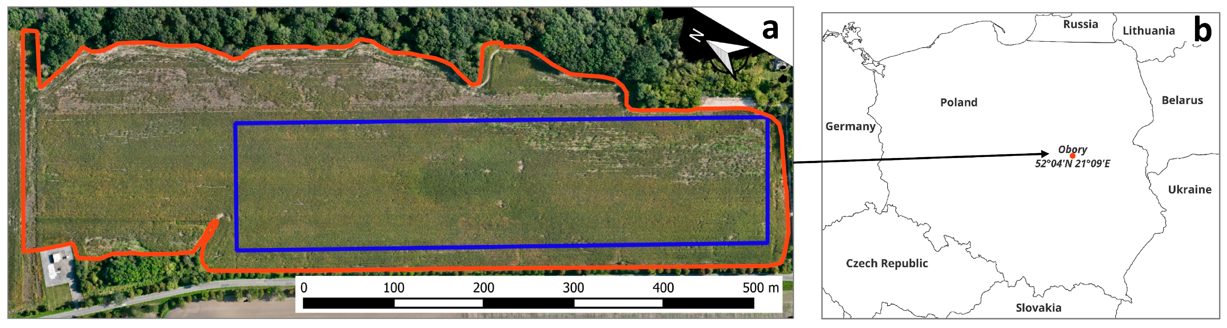
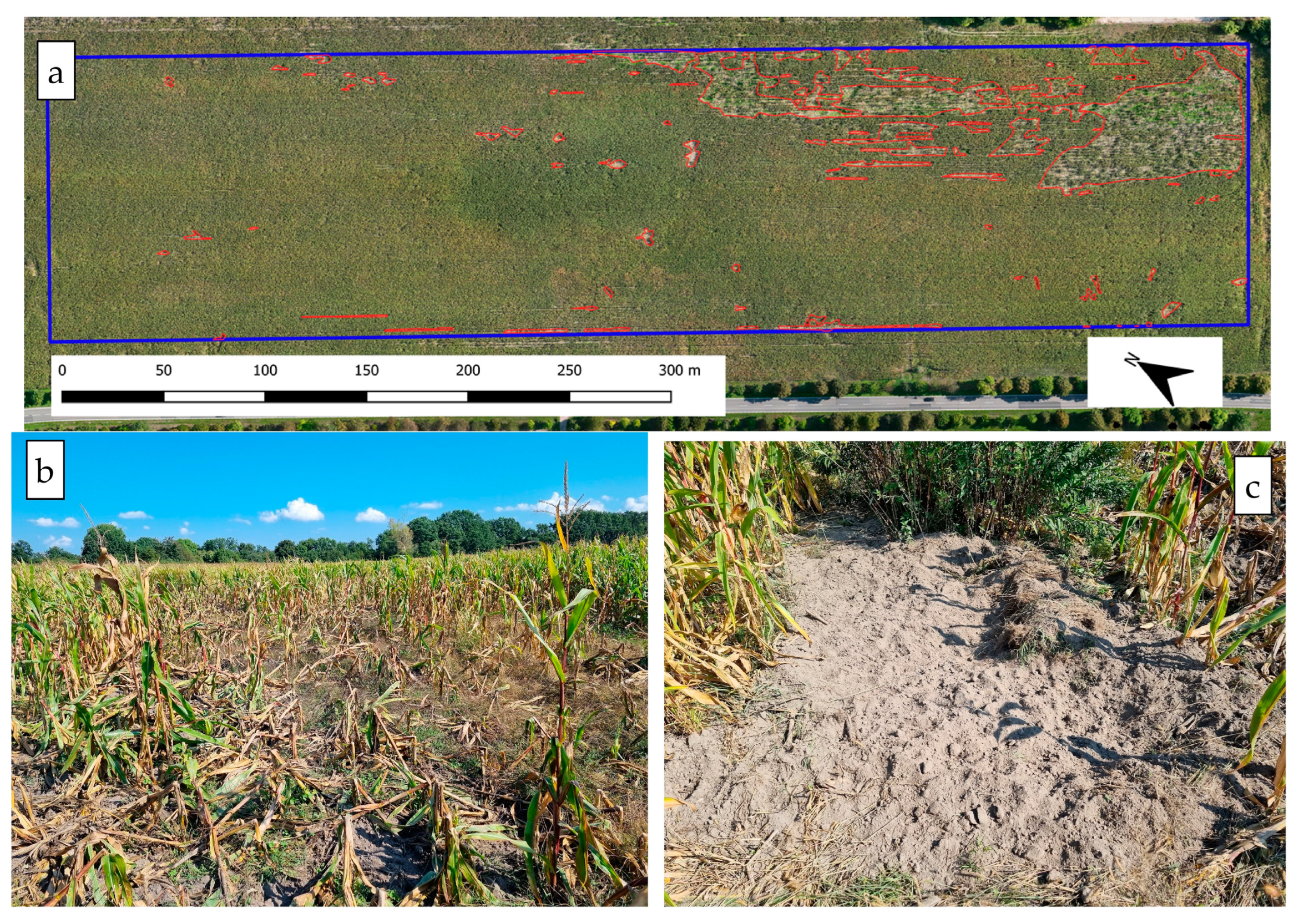
2.1. Study Area and Data Acquisition
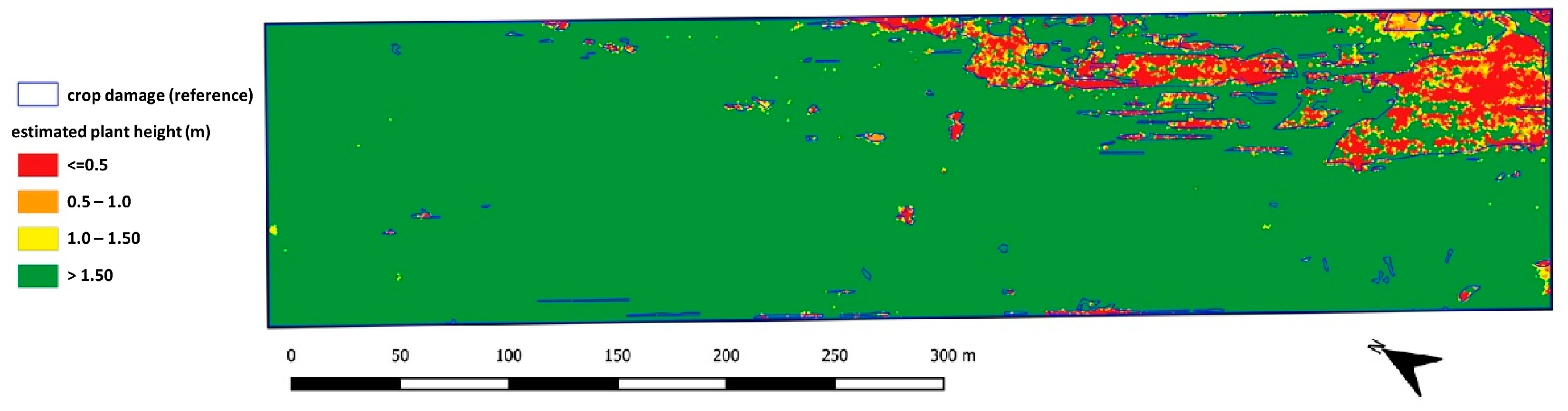
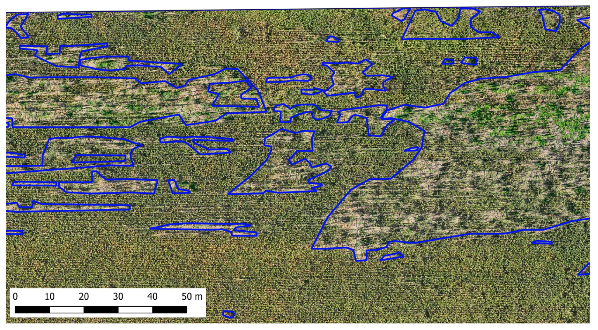
2.2. Data Analysis
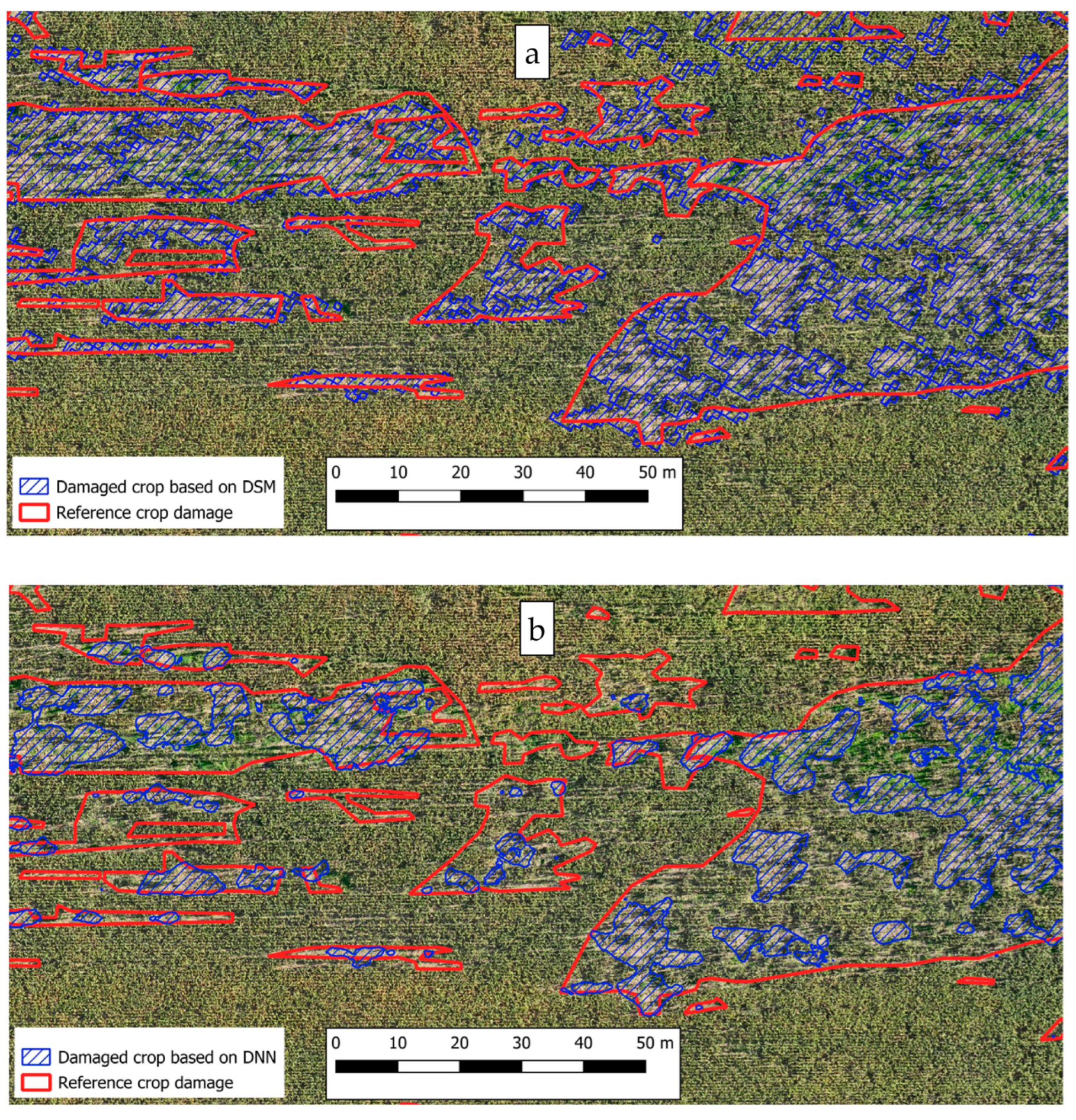
3. Results
- Accuracy = (TP + TN)/(TP + TN + FP + FN);
- Precision (Positive Predictive Value) = TP/(TP + FP);
- Sensitivity (True Positive Rate) = TP/(TP + FN);
- Specificity = TN/(TN + FP).
4. Discussion
5. Conclusions
Author Contributions
Funding
Data Availability Statement
Acknowledgments
Conflicts of Interest
References
- Herrero, J.; García-Serrano, A.; Couto, S.; Ortuño, V.M.; García-González, R. Diet of Wild Boar Sus scrofa L. and Crop Damage in an Intensive Agroecosystem. Eur. J. Wildl. Res. 2006, 52, 245–250. [Google Scholar] [CrossRef]
- Schley, L.; Roper, T.J. Diet of Wild Boar Sus scrofa in Western Europe, with Particular Reference to Consumption of Agricultural Crops. Mammal Rev. 2003, 33, 43–56. [Google Scholar] [CrossRef]
- Amici, A.; Serrani, F.; Rossi, C.M.; Primi, R. Increase in Crop Damage Caused by Wild Boar (Sus scrofa L.): The “Refuge Effect”. Agron. Sustain. Dev. 2012, 32, 683–692. [Google Scholar] [CrossRef]
- Mackin, R. Dynamics of Damage Caused by Wild Boar to Different Agricultural Crops. Acta Theriol. 1970, 15, 447–458. [Google Scholar] [CrossRef]
- Schley, L.; Dufrêne, M.; Krier, A.; Frantz, A.C. Patterns of Crop Damage by Wild Boar (Sus scrofa) in Luxembourg over a 10-Year Period. Eur. J. Wildl. Res. 2008, 54, 589–599. [Google Scholar] [CrossRef]
- Frackowiak, W.; Gorczyca, S.; Merta, D.; Wojciuch-Ploskonka, M. Factors Affecting the Level of Damage by Wild Boar in Farmland in North-eastern Poland. Pest Manag. Sci. 2013, 69, 362–366. [Google Scholar] [CrossRef] [PubMed]
- Laznik, Ž.; Trdan, S. Evaluation of Different Soil Parameters and Wild Boar (Sus scrofa [L.]) Grassland Damage. Ital. J. Anim. Sci. 2014, 13, 3434. [Google Scholar] [CrossRef]
- Rutten, A.; Casaer, J.; Vogels, M.F.A.; Addink, E.A.; Vanden Borre, J.; Leirs, H. Assessing Agricultural Damage by Wild Boar Using Drones. Wildl. Soc. Bull. 2018, 42, 568–576. [Google Scholar] [CrossRef]
- Fischer, J.W.; Greiner, K.; Lutman, M.W.; Webber, B.L.; Vercauteren, K.C. Use of Unmanned Aircraft Systems (UAS) and Multispectral Imagery for Quantifying Agricultural Areas Damaged by Wild Pigs. Crop Prot. 2019, 125, 104865. [Google Scholar] [CrossRef]
- Michez, A.; Morelle, K.; Lehaire, F.; Widar, J.; Authelet, M.; Vermeulen, C.; Lejeune, P. Use of Unmanned Aerial System to Assess Wildlife (Sus scrofa) Damage to Crops (Zea mays). J. Unmanned Veh. Syst. 2016, 4, 266–275. [Google Scholar] [CrossRef]
- Drimaj, J.; Skoták, V.; Kamler, J.; Plhal, R.; Adamec, Z.; Mikulka, O.; Janata, P. Comparison of Methods for Estimating Damage by Wild Ungulates on Field Crops. Agriculture 2023, 13, 1184. [Google Scholar] [CrossRef]
- Kuželka, K.; Surový, P. Automatic Detection and Quantification of Wild Game Crop Damage Using an Unmanned Aerial Vehicle (UAV) Equipped with an Optical Sensor Payload: A Case Study in Wheat. Eur. J. Remote Sens. 2018, 51, 241–250. [Google Scholar] [CrossRef]
- Friesenhahn, B.A.; Massey, L.D.; DeYoung, R.W.; Cherry, M.J.; Fischer, J.W.; Snow, N.P.; VerCauteren, K.C.; Perotto-Baldivieso, H.L. Using Drones to Detect and Quantify Wild Pig Damage and Yield Loss in Corn Fields throughout Plant Growth Stages. Wildl. Soc. Bull. 2023, 47, e1437. [Google Scholar] [CrossRef]
- Jełowicki, Ł.; Sosnowicz, K.; Ostrowski, W.; Osińska-Skotak, K.; Bakuła, K. Evaluation of Rapeseed Winter Crop Damage Using UAV-Based Multispectral Imagery. Remote Sens. 2020, 12, 2618. [Google Scholar] [CrossRef]
- Dobosz, B.; Gozdowski, D.; Koronczok, J.; Žukovskis, J.; Wójcik-Gront, E. Evaluation of Maize Crop Damage Using UAV-Based RGB and Multispectral Imagery. Agriculture 2023, 13, 1627. [Google Scholar] [CrossRef]
- Garcia Millan, V.E.; Rankine, C.; Sanchez-Azofeifa, G.A. Crop Loss Evaluation Using Digital Surface Models from Unmanned Aerial Vehicles Data. Remote Sens. 2020, 12, 981. [Google Scholar] [CrossRef]
- Debnath, S.; Paul, M.; Debnath, T. Applications of LiDAR in Agriculture and Future Research Directions. J. Imaging 2023, 9, 57. [Google Scholar] [CrossRef] [PubMed]
- Puig Garcia, E.; Gonzalez, F.; Hamilton, G.; Grundy, P. Assessment of Crop Insect Damage Using Unmanned Aerial Systems: A Machine Learning Approach; Modelling and Simulation Society of Australia and New Zealand Inc. (MSSANZ): Gold Coast, Australia, 2015; pp. 1420–1426. [Google Scholar]
- Zhang, M.; Wu, B.; Yu, M.; Zou, W.; Zheng, Y. Crop Condition Assessment with Adjusted NDVI Using the Uncropped Arable Land Ratio. Remote Sens. 2014, 6, 5774–5794. [Google Scholar] [CrossRef]
- Marino, S.; Alvino, A. Detection of Homogeneous Wheat Areas Using Multi-Temporal UAS Images and Ground Truth Data Analyzed by Cluster Analysis. Eur. J. Remote Sens. 2018, 51, 266–275. [Google Scholar] [CrossRef]
- Kwak, G.-H.; Park, N.-W. Impact of Texture Information on Crop Classification with Machine Learning and UAV Images. Appl. Sci. 2019, 9, 643. [Google Scholar] [CrossRef]
- Bouguettaya, A.; Zarzour, H.; Kechida, A.; Taberkit, A.M. Deep Learning Techniques to Classify Agricultural Crops Through UAV Imagery: A Review. Neural Comput. Appl. 2022, 34, 9511–9536. [Google Scholar] [CrossRef] [PubMed]
- Teixeira, I.; Morais, R.; Sousa, J.J.; Cunha, A. Deep Learning Models for the Classification of Crops in Aerial Imagery: A Review. Agriculture 2023, 13, 965. [Google Scholar] [CrossRef]
- Aszkowski, P.; Ptak, B.; Kraft, M.; Pieczyński, D.; Drapikowski, P. Deepness: Deep Neural Remote Sensing Plugin for QGIS. SoftwareX 2023, 23, 101495. [Google Scholar] [CrossRef]
- Aszkowski, P.; Ptak, B. Deepness Model ZOO 2022. Available online: https://qgis-plugin-deepness.readthedocs.io/en/latest/main/main_model_zoo.html (accessed on 3 December 2024).
- Beck, H.E.; Zimmermann, N.E.; McVicar, T.R.; Vergopolan, N.; Berg, A.; Wood, E.F. Present and Future Köppen-Geiger Climate Classification Maps at 1-Km Resolution. Sci. Data 2018, 5, 180214. [Google Scholar] [CrossRef] [PubMed]
- Aszkowski, P.; Kraft, M.; Drapikowski, P.; Pieczyński, D. Estimation of Corn Crop Damage Caused by Wildlife in UAV Images. Precis. Agric. 2024, 25, 2505–2530. [Google Scholar] [CrossRef]
- Samiappan, S.; Prince Czarnecki, J.M.; Foster, H.; Strickland, B.K.; Tegt, J.L.; Moorhead, R.J. Quantifying Damage from Wild Pigs with Small Unmanned Aerial Systems. Wildl. Soc. Bull. 2018, 42, 304–309. [Google Scholar] [CrossRef]
- Sarwar, M. Raiding of Agricultural Crops and Forests by Wild Boar (Sus scrofa L.) and Its Mitigation Tricks. J. Sci. Agric. 2019, 3, 01–05. [Google Scholar] [CrossRef]
- Kleijkers, Y.I.M. Wild Boar Damage Mapping in Agricultural Grass and Wheatlands Using Unmanned Aerial Vehicle (UAV) Data. Master’s Thesis, Lund University, Lund, Sweden, 2024. [Google Scholar]
- Rutten, A.; Casaer, J.; Strubbe, D.; Leirs, H. Agricultural and Landscape Factors Related to Increasing Wild Boar Agricultural Damage in a Highly Anthropogenic Landscape. Wildl. Biol. 2019, 2020, 1–11. [Google Scholar] [CrossRef]
- Cai, J.; Jiang, Z.; Zeng, Y.; Li, C.; Bravery, B.D. Factors Affecting Crop Damage by Wild Boar and Methods of Mitigation in a Giant Panda Reserve. Eur. J. Wildl. Res. 2008, 54, 723–728. [Google Scholar] [CrossRef]
- Morelle, K.; Lejeune, P. Seasonal Variations of Wild Boar Sus scrofa Distribution in Agricultural Landscapes: A Species Distribution Modelling Approach. Eur. J. Wildl. Res. 2015, 61, 45–56. [Google Scholar] [CrossRef]
- Bobek, B.; Furtek, J.; Bobek, J.; Merta, D.; Wojciuch-Ploskonka, M. Spatio-Temporal Characteristics of Crop Damage Caused by Wild Boar in North-Eastern Poland. Crop Prot. 2017, 93, 106–112. [Google Scholar] [CrossRef]
- Ficetola, G.F.; Bonardi, A.; Mairota, P.; Leronni, V.; Padoa-Schioppa, E. Predicting Wild Boar Damages to Croplands in a Mosaic of Agricultural and Natural Areas. Curr. Zool. 2014, 60, 170–179. [Google Scholar] [CrossRef]
- Johenneken, M.; Drak, A.; Herpers, R. Damage Analysis of Grassland from Aerial Images Applying Convolutional Neural Networks. In Proceedings of the 2020 International Conference on Software, Telecommunications and Computer Networks (SoftCOM), Split, Croatia, 17–19 September 2020; IEEE: Piscataway, NJ, USA, 2020; pp. 1–6. [Google Scholar]
- Soner, A.; Chourasiya, D.; Rathore, P.; Nikam, G. A Survey on Automatic Crops Damage Assessment Using Remote Sensing. In Proceedings of the 2020 International Conference on Innovative Computing & Communications, Delhi, India, 21–23 February 2020. [Google Scholar] [CrossRef]
- Mitra, A.; Singhal, A.; Mohanty, S.P.; Kougianos, E.; Ray, C. eCrop: A Novel Framework for Automatic Crop Damage Estimation in Smart Agriculture. SN Comput. Sci. 2022, 3, 319. [Google Scholar] [CrossRef]
- Karimzadeh, R.; Naharki, K.; Park, Y.-L. Detection of Bean Damage Caused by Epilachna varivestis (Coleoptera: Coccinellidae) Using Drones, Sensors, and Image Analysis. J. Econ. Entomol. 2024, 117, 2143–2150. [Google Scholar] [CrossRef] [PubMed]
- Tian, F.; Vieira, C.C.; Zhou, J.; Zhou, J.; Chen, P. Estimation of Off-Target Dicamba Damage on Soybean Using UAV Imagery and Deep Learning. Sensors 2023, 23, 3241. [Google Scholar] [CrossRef]
- Azizi, A.; Zhang, Z.; Rui, Z.; Li, Y.; Igathinathane, C.; Flores, P.; Mathew, J.; Pourreza, A.; Han, X.; Zhang, M. Comprehensive Wheat Lodging Detection after Initial Lodging Using UAV RGB Images. Expert Syst. Appl. 2024, 238, 121788. [Google Scholar] [CrossRef]
- Jurado, J.M.; Pádua, L.; Feito, F.R.; Sousa, J.J. Automatic Grapevine Trunk Detection on UAV-Based Point Cloud. Remote Sens. 2020, 12, 3043. [Google Scholar] [CrossRef]
- Sibanda, M.; Ndlovu, H.S.; Brewer, K.; Buthelezi, S.; Matongera, T.N.; Mutanga, O.; Odidndi, J.; Clulow, A.D.; Chimonyo, V.G.P.; Mabhaudhi, T. Remote Sensing Hail Damage on Maize Crops in Smallholder Farms Using Data Acquired by Remotely Piloted Aircraft System. Smart Agric. Technol. 2023, 6, 100325. [Google Scholar] [CrossRef]
- Mohammad, L.; Bandyopadhyay, J.; Sk, R.; Mondal, I.; Nguyen, T.T.; Lama, G.F.C.; Anh, D.T. Estimation of Agricultural Burned Affected Area Using NDVI and dNBR Satellite-Based Empirical Models. J. Environ. Manag. 2023, 343, 118226. [Google Scholar] [CrossRef] [PubMed]


| Method of Evaluation | Total Area (in m2) | Percentage of the Field |
|---|---|---|
| Manual (based on visual assessment) | 8642 | 10.50% |
| Based on DSM and DEM (difference below 1.5 m *) | 7781 | 9.45% |
| Using deep neural networks | 3303 | 4.01% |
| Method of Evaluation | Based on DSM | Using Deep Neural Networks |
|---|---|---|
| True positive (TP)—classified correctly as crop damage | 6037 | 3047 |
| False positive (FP)—classified incorrectly as crop damage | 1744 | 256 |
| True negative (TN)—correctly identified as undamaged | 71,924 | 73,412 |
| False negative (FN)—incorrectly identified as undamaged | 2605 | 5595 |
| Method of Evaluation | Based on DSM | Using Deep Neural Networks |
|---|---|---|
| Accuracy = (TP + TN)/(TP + TN + FP + FN) | 0.947 | 0.929 |
| Precision (Positive Predictive Value) = TP/(TP + FP) | 0.776 | 0.922 |
| Sensitivity (True Positive Rate) = TP/(TP + FN) | 0.699 | 0.353 |
| Specificity = TN/(TN + FP) | 0.976 | 0.997 |
| Method of Evaluation | Manual Selection | Based on DSM | Using Deep Neural Networks |
|---|---|---|---|
| Accuracy | high | moderate to high | low to high |
| Time-consuming | very high | moderate | low |
| Costs of data acquisition | low | moderate to high | low |
| Costs of data analysis | high costs due to high time consumption | moderate | low (assuming that the model is already developed) |
| Overall assessment of the method | easy to apply only in small areas, time-consuming on large fields | good efficiency but requires expensive LiDAR sensors | low costs, easy application but in case of atypical crop damage, accuracy can be insufficient |
Disclaimer/Publisher’s Note: The statements, opinions and data contained in all publications are solely those of the individual author(s) and contributor(s) and not of MDPI and/or the editor(s). MDPI and/or the editor(s) disclaim responsibility for any injury to people or property resulting from any ideas, methods, instructions or products referred to in the content. |
© 2025 by the authors. Licensee MDPI, Basel, Switzerland. This article is an open access article distributed under the terms and conditions of the Creative Commons Attribution (CC BY) license (https://creativecommons.org/licenses/by/4.0/).
Share and Cite
Dobosz, B.; Gozdowski, D.; Koronczok, J.; Žukovskis, J.; Wójcik-Gront, E. Detection of Crop Damage in Maize Using Red–Green–Blue Imagery and LiDAR Data Acquired Using an Unmanned Aerial Vehicle. Agronomy 2025, 15, 238. https://doi.org/10.3390/agronomy15010238
Dobosz B, Gozdowski D, Koronczok J, Žukovskis J, Wójcik-Gront E. Detection of Crop Damage in Maize Using Red–Green–Blue Imagery and LiDAR Data Acquired Using an Unmanned Aerial Vehicle. Agronomy. 2025; 15(1):238. https://doi.org/10.3390/agronomy15010238
Chicago/Turabian StyleDobosz, Barbara, Dariusz Gozdowski, Jerzy Koronczok, Jan Žukovskis, and Elżbieta Wójcik-Gront. 2025. "Detection of Crop Damage in Maize Using Red–Green–Blue Imagery and LiDAR Data Acquired Using an Unmanned Aerial Vehicle" Agronomy 15, no. 1: 238. https://doi.org/10.3390/agronomy15010238
APA StyleDobosz, B., Gozdowski, D., Koronczok, J., Žukovskis, J., & Wójcik-Gront, E. (2025). Detection of Crop Damage in Maize Using Red–Green–Blue Imagery and LiDAR Data Acquired Using an Unmanned Aerial Vehicle. Agronomy, 15(1), 238. https://doi.org/10.3390/agronomy15010238