Article

Decision Support System for Selecting Mung Bean Cultivation Sites in Central Thailand Based on Soil Suitability Class

by
Napaporn Phankamolsil
1,
Sirinapa Chungopast
1,*,
Kiattisak Sonsri
1,
Kridsopon Duangkamol
2,
Suwicha Polfukfang
2 and
Prakit Somta
3
1
Department of Soil Science, Faculty of Agriculture at Kamphaeng Saen, Kasetsart University, Kamphaeng Saen Campus, Nakhon Pathom 73140, Thailand
2
Land Development Department, Lat Yao, Chatuchak, Bangkok 10900, Thailand
3
Department of Agronomy, Faculty of Agriculture at Kamphaeng Saen, Kasetsart University, Kamphaeng Saen Campus, Nakhon Pathom 73140, Thailand
*
Author to whom correspondence should be addressed.
Agronomy 2023, 13(4), 1030; https://doi.org/10.3390/agronomy13041030
Submission received: 28 February 2023 / Revised: 20 March 2023 / Accepted: 27 March 2023 / Published: 30 March 2023
(This article belongs to the Section Agricultural Biosystem and Biological Engineering)

Abstract

:
Information to aid the selection of suitable cultivated areas remains meager for mung bean, despite it being a socio-economically important legume crop in Thailand. Hence, a user-friendly soil assessment tool is required to help properly choose planting areas. We aimed to provide a decision support system for mung bean cultivation in central Thailand. Soil suitability classes were performed using relevant factors and data essential for mung bean cultivation in 22 provinces in central Thailand. A decision support system was developed as soil map and mobile phone application using data based on soil suitability classes. Information of mung bean growth and yield grown in experimental fields with different soil suitability classes was used for preliminary validation. The main areas were very suitable (S1) and moderately suitable (S3) for mung bean plantation, accounting for 1,319,841 and 1,327,804 ha, respectively. The number of pods per plant and yield per plant of mung bean were higher in S1 areas (12.83–16.65 pods per plant and 8.35–12.43 g/plant, respectively) than in S3 areas. The mung bean yield was also greater in S1 areas (1613.8–2158.7 kg/ha) than in S3 areas (735.8–1138.6 kg/ha). The findings suggest the possibility of using developed decision support system.

1. Introduction

Legumes are economic crops that play an important role in food systems to address future global food security, environmental sustainability, and nutritional demand [1,2]. In Thailand, the legumes that are produced and utilized are diverse in terms of their species such as mung beans, soybeans, and peanuts [3,4]. It has been reported that bean production from both domestic and international businesses accounts for USD 0.30 billion per year. With regard to the mung bean, it is not only used in the vermicelli, bean sprouts, and confectionery industries, but is also used as the animal forage crop, and medicinal component [5,6,7]. As a soil improvement aspect, the mung bean is used in the form of green manure that particularly provides nitrogen (N) to the soil, since it can fix atmospheric N via nitrogen-fixing bacteria [8,9]. In 2020, the cultivated area of mung bean in Thailand was 130,215 ha, with a total yield of 111,235 tons and an average yield of 854.25 kg/ha. At present, mung bean production is insufficient for the domestic demand, resulting in large amounts being imported from other countries every year [10]. Hence, it is imperative to expand mung bean cultivation in Thailand to increase the domestic supply.
The mung bean is a short-lived plant that germinates quickly and uses a small amount of water compared to many other field crops. It is commonly cultivated in crop rotation, such as planting before or after paddy rice. It is grown to maintain soil fertility and to reduce cycles of pest infestations [11,12]. However, it has been revealed that humid or flooded areas and areas subjected to waterlogging are not suitable for mung bean growth, especially during the early growing stages [13,14]. Such unsuitability is based on the fact that waterlogging is an inhibition of photosynthesis [15,16], which is fundamentally associated with yield [13]. Therefore, in order to increase the yield of mung bean, it is vital to properly select cultivated areas that are appropriate for mung bean. Nonetheless, the accurate selection by most farmers of suitable areas for planting mung bean remains problematical.
For the classification of soil suitability based on the Food and Agriculture Organization system [17], it requires information including land use, land characteristics, and land quality. According to the guidelines proposed by FAO, 25 types of limitation factors are considered to determine the soil suitability classification for crop cultivation. Thus, the classification of mung bean soil suitability and further development of a decision support system will be helpful in selecting appropriate areas for mung bean cultivation in Thailand.
Soil maps, which consist of soil properties and nutrient statuses are essential for promoting the agricultural production and sustainable soil management [18,19], as well as selecting the suitable areas for economic crops. In agriculture, the demand for mobile applications is increasing since smartphones are constantly being developed and used for a variety of purposes, such as management of pests and diseases in field crops [20]. Nevertheless, the development of applications based on relevant soil information to assist the farmers in selecting optimal areas for economic crops, especially mung bean, remains imperfectly established in Thailand. Taking the advantages of soil maps and mobile application, it may be able to establish a decision support system for aiding the farmers to choose the suitable areas for mung bean cultivation with easy access.
In the present study, we aimed at developing a decision support system for mung bean cultivation in the central region of Thailand. In order to accomplish this purpose, the suitable areas for mung bean cultivation were classified based on provincial soil map data and the obtained data were further used to generate a decision support system in terms of soil map and mobile application.

2. Materials and Methods

Areas in central Thailand were chosen to evaluate the soil suitability for mung bean cultivation. Primary information was sourced from soil maps at a scale of 1:25,000 and relevant soil data for all provinces in the central region that were obtained as a shapefile from the Land Development Department, Ministry of Agriculture and Cooperatives, Thailand [21], using the steps depicted in Figure S1. Based on these data, the information pertaining to the soil properties associated with suitability for growing mung beans was imported into a database. In addition, the study incorporated relevant factors used to classify soil suitability proposed by the Food and Agriculture Organization [17] with adjustments regarding the types of limitations and suitability classes applicable in Thailand. The parameters used are shown in Table 1. Data processing to generate the suitability classes for mung bean cultivation was performed using the Microsoft Excel program. The soil suitability database for mung bean planting was imported into a GIS program for analysis and illustration of the results as a map showing soil suitability for mung bean planting in central Thailand.
The systematic processes of the decision support system development are presented in Figure 1. The relevant data (soil series and limitation factors) were generated in a database of soil suitability classes and further used for the mobile application development. The development of the procedures for the mobile application commenced with analyzing all the requirements for the system process (phase 1), followed by the design of the workflow process, user interface, and system structure (phase 2). Afterward, the relevant data based on the soil suitability classes for mung bean cultivation were analyzed and imported into the developed system (phase 3). The developed system was tested, verified (phase 4), and subsequently deployed to the server (phase 5).
In this development, Flutter was applied as the main platform for developing a mobile application and Dart was used as a programming language in Flutter. To test the application, a mobile phone was used as the tool for simulation of the application and to implement any corrections required. Eventually, the application (called “Mung Bean Soil Suitability”) was introduced as a mobile application and used for selecting areas suitable for mung bean cultivation.
To test the performance of the developed decision support system, the data regarding the agronomic and yield-related traits, and the yield of mung beans that were grown in different fields [22], were used to preliminarily validate. Four cultivated fields were located in the Kamphaeng Saen (KS), Kamphaeng Saen district, Nakhon Pathom province (14°2′9.3″ N, 100°10′45.0″ E), the Kok Tum (KT), Mueang Lopburi district, Lopburi province (14°47′55.2″ N, 100°48′5.3″ E), the Suk Samran (SS), Tak Fa district, Nakhon Sawan province (15°20′58.9″ N, 100°34′36.9″ E), and the Sadieng (SD), Mueang Phetchabun district, Phetchabun province (16°27′38.2″ N, 101°9′40.1″ E). Three mung bean cultivars, i.e., CN84-1, KPS2, and KUML4, were grown in each location and their agronomic and yield-related traits and yield were recoded, consisting of days to maturity, plant height at day of maturity, number of nodes per plant, number of pods per plant, yield per plant, and yield.

3. Results

3.1. Mung Bean Planting Areas

Analysis of the data indicated that mung bean was planted in 11 provinces in central Thailand, as shown in Table 2. Cultivation was either in the dry season (after a rice crop) or in the rainy season. Phetchabun province had the largest mung bean planting area in the rainy season, whereas Uthai Thani province accounted for the largest total area of mung bean cultivation for the combine cultivation seasons. In the rainy season, mung bean was planted in upland areas. On the other hand, mung bean was cultivated after a rice crop in lowland areas or paddy soil.

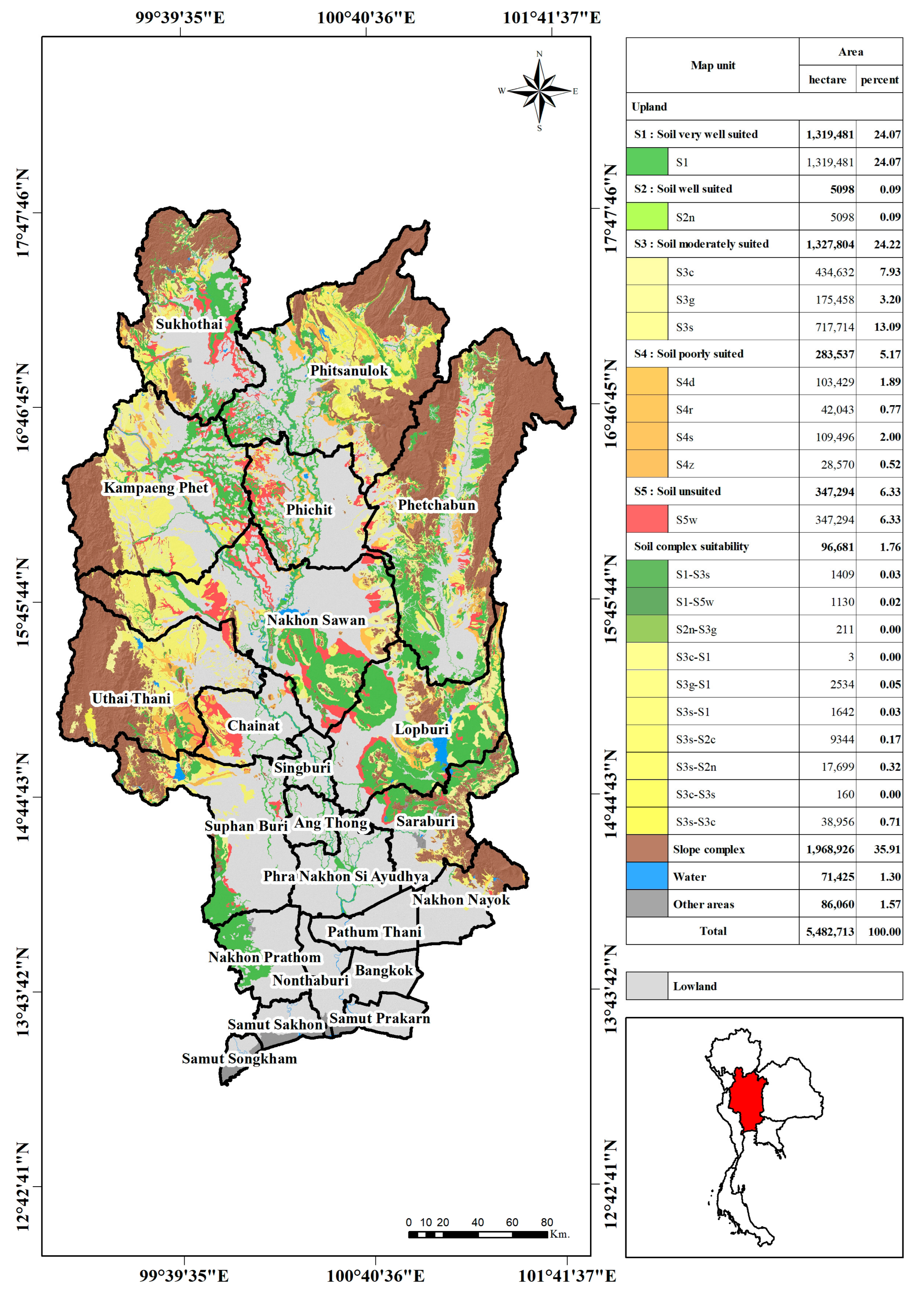
3.2. Soil Suitability Assessment for Mung Bean Cultivation

The database for the classification of soil suitability for mung bean cultivation according to the restriction conditions for mung bean growth was generated using the soil properties based on the provincial soil maps for upland soils, as shown in Table 3 and Figure 2. As this study was focused on identifying soil suitability for mung bean cultivation in normal crops (rainy season on upland soil), the paddy soil (lowland soil) used for rice cultivation was separated from this classification and is shown in gray on the map (Figure 2).
The assessment of the soil suitability for mung bean plantation indicated the study area could be classified as very suitable for mung bean cultivation (S1) covering 1,319,841 ha (Table 3), as shown by the green color on the map in Figure 2. Most of these areas were in Phetchabun, Nakhon Sawan, Lopburi, and Saraburi provinces, and the western parts of Suphan Buri and Nakhon Pathom provinces. In addition, these areas were interspersed with lowland areas in the Sukhothai, Phitsanulok, Kamphaeng Phet, and Phichit provinces (Figure 2). The area classified as suitable for mung bean planting (S2) accounted for only 5098 ha (Table 3), as shown by the light green color on the map in Figure 2. The limitation for this suitability class was that soil fertility was low (n), with no other constraints. Such classified areas were found in Phitsanulok province.
The moderately suitable areas for mung bean plantation (S3) are shown on the map in 3 shades of yellow, covering 1,327,804 ha (Table 3). The limitations for this suitability class were the presence of a consolidation layer (>60%) at a depth of 25–50 cm (c), gravel (35–60%) at a depth of 25–50 cm (g), and coarse textured soil (s). Areas classified as S3 were found in Nakhon Sawan, Uthai Thani, Phetchabun, Kamphaeng Phet, Phitsanulok, Sukhothai, and Saraburi provinces.
The areas that were poorly suitable for mung bean cultivation (S4) are shown on the map, using 4 color shades from orange to brown (Figure 2). S4 accounted for 283,537 ha (Table 3). In this suitability classification, the constraint factors were soil drainage (d), rockiness (10–50% of the area; r), coarse textured soil (s), and stoniness (15–50% of the area; z). The areas that were characterized as S4 were in Nakhon Sawan, Uthai Thani, Phetchabun, Kamphaeng Phet, Phitsanulok, Sukhothai, Phichit, Lopburi, Saraburi, Suphanburi, Chainat, and Nakhon Nayok provinces. The areas that were classified as unsuitable for mung bean plantation (S5) are exhibited on the map in red, making up 347,294 ha (Figure 2 and Table 3). Water logging (w) was the main constraint factor for this classification. Areas classified as S5 were in Nakhon Sawan, Kamphaeng Phet, Phichit, Phitsanulok, Phetchabun, Sukhothai, Uthai Thani, Lopburi, Saraburi, Suphan Buri, Chainat, Nakhon Pathom, and Nakhon Nayok provinces. Beyond the suitability classes S1 to S5, complex soil units accounted for 96,681 ha (Table 3), such as areas expressed as S1–S3s, S1–S5w, and S2n–S3g.

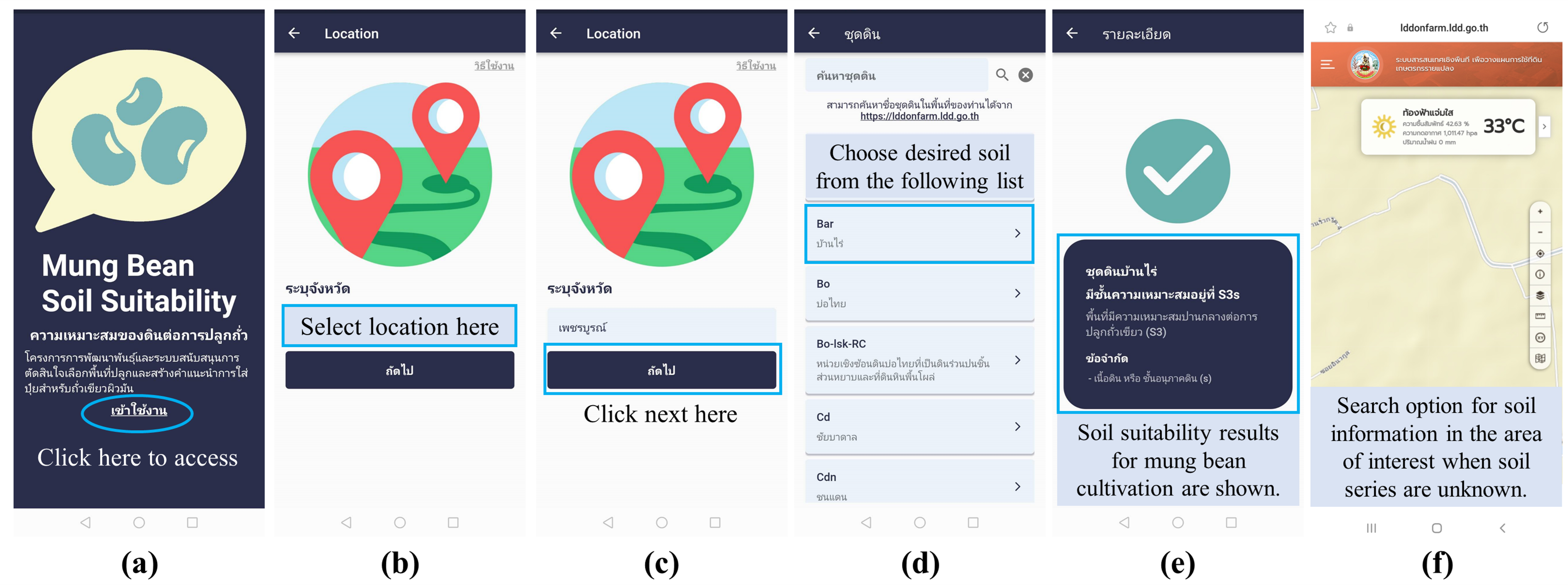
3.3. Decision Support System for Mung Bean Plantation as a Mobile Application

The development of a decision support system for mung bean plantation based on the dataset obtained from the soil suitability classification was incorporated into a new mobile application involving simple steps for selecting the suitable areas for mung bean cultivation. The design and screens of the mobile application are shown in Figure 3. First, users must install the “mung bean soil suitability” application on their mobile phones; it can be downloaded from Google Play Store. Then, after accessing the application, the application window shown in Figure 3a will be displayed. Then, the desired province is selected (Figure 3b), and subsequently, “Next” is pressed (Figure 3c). A screen showing the list of soil series or soil map unit names will appear and the user selects the name of the desired soil from the lists of soil series (Figure 3d). Finally, the user is presented with a screen showing the results of soil suitability for mung bean cultivation with the necessary description (Figure 3e). For the unknown soil series in the selected area, the users can optionally choose the link “https://lddonfarm.ldd.go.th (accessed on 25 March 2022)” and use the LDD On Farm Land Use Planning information to search for soil information on their area of interest, as shown in Figure 3f.

3.4. Agronomic and Yield-Related Traits, and Yield of Mung Beans in the Cultivated Areas with Different Soil Suitability Classes

Based on soil suitability classes, the selected areas that used for cultivation of mung bean at the KS, KT, SS, and SD sites were categorized as S1, S1, S3c, and S3s, respectively (Table 4). Among the different cultivated locations, the days to maturity of mung bean in KS (54.25–54.75 days) was shorter than the other fields (54.25–66.75 days), irrespective of the cultivars (Table 4). The plant height at day of maturity and number of nodes per plant were greatest in the KS area, ranging from 93.10–97.68 cm and 12.18–13.33 nodes per plant, respectively (Table 4). The number of pods per plant and yield per plant of mung bean were higher in the KS and KT fields (12.83–16.65 pods per plant and 8.35–12.43 g/plant, respectively) than the SS and SD fields. The mung bean yield was also higher in the KT and KS fields (1613.8–2158.7 kg/ha) in comparison to the SS and SD fields (735.8–1138.6 kg/ha).

4. Discussion

The study showed that the planting areas of mung bean consisted of two types. In detail, in the rainy season, mung bean was grown in upland areas, while it was cultivated after a rice crop in lowland areas or paddy soil (Table 2). Under such contrasting soil conditions, the soil characteristics were typically different, which may have further resulted in differences in the growth and yield of mung bean.
Optimization of land use potential is very vital for supporting national food security and agribusiness development, and for that, information about the potential and the availability of land resources was required. It has also been suggested that the land resource data can be utilized to construct a thematic map, such as maps of land suitability for various commodities, land-use map directions, and the agriculture spatial map direction [23]. In this study, an assessment of land suitability classes for mung bean plantation in the central region of Thailand was conducted according to the Food and Agriculture Organization system [17] with adjustments regarding the types of limitations and suitability classes applicable in Thailand. The main areas in the central region were classified as very suitable (S1) and moderately suitable (S3) areas (Table 3 and Figure 2). The finding suggests that the areas of S1 that covered 1,319,841 ha and mainly located in Phetchabun, Nakhon Sawan, Lopburi, and Saraburi provinces, and western parts of Suphan Buri and Nakhon Pathom provinces (Figure 2) can firstly be considered to be the areas for mung bean plantation and vice versa for the areas that were classified as S5, which was mainly classified based on the areas faced with water logging. Moreover, in Nakhon Pathom province, the salinity level may have been another limitation restricting mung bean growth, as the soil in many areas in Kamphaeng Saen district, Nakhon Pathom province was salt-affected, having electrical conductivity (ECe) >6 dS/m [24], in accordance with the classification of S5 (Table 1). The potential utilization of GIS and multi-criteria decision-making approach for mung bean cultivation can provide important guidance for future land use changes and also cost-effective solutions [25]. The digital soil maps generated in the study can also provide important information for indicating the soil nutrients status, and this soil information can be used for land-use planning, decision-making support to improve soil fertility, and monitoring soil conditions for long-term trends [26].
It has been shown that the development of mobile applications in agriculture has greatly influenced farming and aided in the monitoring of crop status by farmers and agricultural officers. As such, the mobile application is pivotal in agriculture, which can help farmers to manage their farms effectively compared to conventional methods [20]. Moreover, they suggest that no training is required to use the applications, and farmers can easily use such application. Previous work in Indonesia developed a tool for land suitability evaluation by transforming the FAO framework into a smart mobile application for rubble, cocoa, and oil palm. They observed that the usability of the system had a very good classification, which is that all dimensions are between 3.68 and 4.01 [27]. In the present study, we also developed a decision support system for mung bean plantation based on the dataset obtained from the soil suitability classification in the platform of mobile application, i.e., Mung Bean Soil Suitability, in addition to soil map (Figure 3). This developed application recently covers 22 provinces in the central region of Thailand. Nevertheless, in the future, further development of a mobile application for selecting the suitable areas for mung bean cultivation will cover all mung bean planting areas in Thailand. Previous works have demonstrated that the developed applications are mostly focused on describing pests and diseases [28,29]. In addition to those mobile application, we developed the Mung Bean Soil Suitability as an optional application that can be used to select the suitable areas for mung bean plantation. The developed application can be easily accessed by farmers without any fee. The application might also assist farmers in making a decision whether to shift from former crop cultivation into mung bean cultivation, an alternative protein source crop.
The potential capability of the developed decision support system was preliminarily tested based on the data obtained from the experimental fields [22], in which the mung beans were cultivated in the areas with different soil suitability classes. It was clearly seen that the agronomic traits of mung bean, namely, days to maturity, plant height at day of maturity, number of nodes per plant were superior in the soil that was classified as S1 (KS site), irrespective of the cultivars (Table 4). Furthermore, the yield-related traits (i.e., number of pods per plant, yield per plant) and yield of mung bean, were also higher in the areas that were classified as S1 (both KS and KT sites) in comparison to those in the SS and SD sites where the soils were classified upon soil suitability class as S3c and S3s, respectively (Table 4). In the SS site, the limiting factor was the high soil consolidation layer, which may limit root development and subsequently result in shoot growth as well as yield-related traits and yield of mung bean. Previous work found that the emergence, root length, and root diameter of pea were affected by soil consolidation in clay loam soil texture but had no effect on such characteristics in loamy sand soil texture [30]. The Takhli soil series in the SS site (Table 4) may be the first case since such soil series had a clay texture [31]. In the SD site, the limiting factor was soil texture, which was sandy loam. Generally, it has been shown that sandy soils have low nutrient and water holding capacities [32,33]. This may further affect the insufficient uptake of nutrients and water of mung bean, thus resulting in their lower growth, yield-related traits and yield in the SD site. These results presumably support the possible utilization of the decision support system that is beneficial for the enhancement of growth, yield-related traits and yield of mung bean in the study areas, which may further help the farmers to select the better areas for mung bean cultivation.
Since the application contains only the soil data in areas of the 22 provinces in central Thailand, this may cause the limitation of utilization for the users from the other regions. In addition, because the paddy crop (lowland soil) areas were separated from the classified areas, this resulted in no data for such locations in this application. Thus, further development for covering those remaining areas should be persuaded in future work.

5. Conclusions

This study identified the suitability level for areas in central Thailand regarding mung bean cultivation based on the selected data to classify those areas. Subsequently, the soil map was generated as a primary information and mobile phone application (“Mung Bean Soil Suitability”) was developed based on the soil suitability classification data. Across the 22 provinces in the studied regions, the major areas were classified as very suitable (S1) and moderately suitable (S3) classes for mung bean plantation, occupying for 1,319,841 ha and 1,327,804 ha, respectively. The comparison of the information pertaining to the agronomic and yield-related traits, and yield of mung beans that were cultivated in the experimental fields with different soil suitability classes (S1 and S3) showed that the days to maturity, plant height at day of maturity, number of nodes per plant, number of pods per plant, yield per plant, and yield of mung bean were superior in the areas that were classified as S1 (KS and KT sites) compared to S3 (SS and SD sites). These results suggest the possibility of using decision support system to select suitable areas for mung bean plantation. The users, such as agriculturists and interested parties can take advantage of the mobile phone application as an optional decision support system that may help to more efficiently choose suitable areas to cultivate mung bean. Nevertheless, because of the most important limitation of the current mobile application, that is, the total areas covering 22 provinces in central Thailand and having no data in lowland soil areas, future work will focus on the remaining areas.

Supplementary Materials

The following supporting information can be downloaded at: https://www.mdpi.com/article/10.3390/agronomy13041030/s1, Figure S1: Steps for obtaining the primary information from the website established by the Land Development Department (http://dinonline.ldd.go.th/Login.aspx?service=4 (accessed on 27 February 2023)); Table S1: Full names of soil mapping unit.

Author Contributions

Conceptualization, N.P. and P.S.; methodology, N.P. and S.C.; software, K.D. and S.P.; validation, N.P., S.C. and K.D.; formal analysis, N.P. and S.C.; investigation, N.P. and S.C.; resources, P.S. and K.D.; data curation, N.P., K.S. and S.P.; writing—original draft preparation, S.C. and K.S.; writing—review and editing, N.P., S.C. and K.S.; visualization, S.P.; supervision, N.P.; project administration, P.S.; funding acquisition, P.S. All authors have read and agreed to the published version of the manuscript.

Funding

This research was funded by the Kasetsart University Research and Development Institute (KURDI), Bangkok, Thailand, grant number FF(KU)1.64.

Data Availability Statement

Not applicable.

Acknowledgments

The research was supported by funding from the Kasetsart University Research and Development Institute (KURDI), Bangkok, Thailand (FF(KU)1.64).

Conflicts of Interest

The authors declare no conflict of interest.

References

  1. de Jager, I.; Borgonjen-van den Berg, K.J.; Giller, K.E.; Brouwer, I.D. Current and potential role of grain legumes on protein and micronutrient adequacy of the diet of rural Ghanaian infants and young children: Using linear programming. Nutr. J. 2019, 18, 12. [Google Scholar] [CrossRef] [PubMed]
  2. Sequeros, T.; Ochieng, J.; Schreinemachers, P.; Binagwa, P.H.; Huelgas, Z.M.; Hapsari, R.T.; Juma, M.O.; Kangile, J.R.; Karimi, R.; Khaririyatun, N.; et al. Mungbean in Southeast Asia and East Africa: Varieties, practices and constraints. Agric. Food Secur. 2021, 10, 1–13. [Google Scholar] [CrossRef]
  3. Vangnai, S. Current situation of nodulated legumes in Thailand. J. Sci. Soc. Thailand 1981, 7, 18–24. [Google Scholar] [CrossRef]
  4. Sutjaritjai, N.; Wangpakapattanawong, P.; Balslev, H.; Inta, A. Traditional uses of Leguminosae among the Karen in Thailand. Plants 2019, 8, 600. [Google Scholar] [CrossRef]
  5. Corn, Soybeans, Mung Beans and Peanuts: Direction of Thai Economic Crops in ASEAN. Available online: https://www.arda.or.th/ebook/file/5Policy4.pdf (accessed on 2 March 2022).
  6. Aung, P.P.P.; Lee, J.Y. Technical efficiency of mung bean producers: The case of Myanmar. Agriculture 2021, 11, 1249. [Google Scholar] [CrossRef]
  7. Wang, L.; Wang, S.; Luo, G.; Zhang, J.; Chen, Y.; Chen, H.; Cheng, X. Evaluation of the production potential of mung bean cultivar “Zhonglv 5”. Agronomy 2022, 12, 707. [Google Scholar] [CrossRef]
  8. Favero, V.O.; Carvalho, R.H.; Motta, V.M.; Leite, A.B.C.; Coelho, M.R.R.; Xavier, G.R.; Rumjanek, N.G.; Urquiaga, S. Bradyrhizobium as the only rhizobial inhabitant of mung bean (Vigna radiata) nodules in tropical soils: A strategy based on microbiome for improving biological nitrogen fixation using bio-products. Front. Plant Sci. 2021, 11, 602645. [Google Scholar] [CrossRef]
  9. Ali, M.; Gupta, S. Carrying capacity of Indian agriculture: Pulse crops. Curr. Sci. 2012, 102, 874–881. [Google Scholar]
  10. Thailand Foreign Agricultural Trade Statistics. Available online: http://dataset.nabc.go.th/dataset/6196e084-2e4e-4bc7-888c-49336aaf3c7e/resource/62220b44-c151-4f25-976e-e07657de9dc7/download/31-02-63.pdf (accessed on 25 March 2022).
  11. Nadeem, F.; Nawaz, A.; Farooq, M. Crop Rotations, Fallowing, and Associated Environmental Benefits. In Oxford Research Encyclopedia of Environmental Science; Oxford University Press: Oxford, UK, 2019. [Google Scholar]
  12. Peiris, H.; Kaveeta, R.; Rangsipaht, S.; Pitakdantham, R. Effects of Thailand and Sri Lanka agronomic practices on Mungbean (Vigna radiata (L.) Wilczek) production in rice-based cropping system. Agric. Nat. Resour. 2016, 50, 286–290. [Google Scholar] [CrossRef]
  13. Kumar, P.; Pal, M.; Joshi, R.; Sairam, R.K. Yield, growth and physiological responses of mung bean [Vigna radiata (L.) Wilczek] genotypes to waterlogging at vegetative stage. Physiol. Mol. Biol. Plants 2013, 19, 209–220. [Google Scholar] [CrossRef]
  14. Singh, D.P.; Singh, B.B. Breeding for tolerance to abiotic stresses in mungbean. J. Food Legum. 2011, 24, 83–90. [Google Scholar]
  15. Ahmed, S.; Higuchi, H.; Nawata, E.; Sakuratani, T. Effects of exogenous ABA and ethylene application and waterlogging on photosynthesis in mungbean (Vigna radiata (L.) Wilczak). Jpn. J. Trop. Agric. 2002, 46, 166–174. [Google Scholar]
  16. Ahmed, S.; Nawata, E.; Sakuratani, T. Changes of endogenous ABA and ACC, and their correlations to photosynthesis and water relations in mungbean (Vigna radiata (L.) Wilczak cv. KPS1) during waterlogging. Environ. Exp. Bot. 2006, 57, 278–284. [Google Scholar] [CrossRef]
  17. FAO. A Framework for Land Evaluation. In Soil Resources, Development and Conservation Service, Land and Water Development Division; Food and Agriculture Organization of the United Nations: Rome, Italy, 1976. [Google Scholar]
  18. Forkuor, G.; Hounkpatin, O.K.; Welp, G.; Thiel, M. High resolution mapping of soil properties using remote sensing variables in south-western Burkina Faso: A comparison of machine learning and multiple linear regression models. PLoS ONE 2017, 12, e0170478. [Google Scholar] [CrossRef] [PubMed]
  19. Kalambukattu, J.G.; Kumar, S.; Arya Raj, R. Digital soil mapping in a Himalayan watershed using remote sensing and terrain parameters employing artificial neural network model. Environ. Earth Sci. 2018, 77, 1–14. [Google Scholar] [CrossRef]
  20. Che’Ya, N.N.; Mohidem, N.A.; Roslin, N.A.; Saberioon, M.; Tarmidi, M.Z.; Arif Shah, J.; Fazlil Ilahi, W.F.; Man, N. Mobile computing for pest and disease management using spectral signature analysis: A review. Agronomy 2022, 12, 967. [Google Scholar] [CrossRef]
  21. Soil Data Service and Use. Available online: http://dinonline.ldd.go.th/Login.aspx?service=4 (accessed on 25 March 2022).
  22. Somta, P.; Ngampongsai, S.; Masari, A.; Phoomthaisong, J.; Phruetthithep, C.; Bunsak, C.; Punlai, N.; Suwanprasert, J.; Thiempeng, P.; Budthong, T. Advanced Yield Trial of New Mungbean Breeding Lines of Thailand: Final Report; National Science and Technology Development Agency: Nakhon Pathom, Thailand, 2017. [Google Scholar]
  23. Sirappa, M.P.; Waas, E.D.; Susanto, A.N. Land suitability and purposed land use of Selaru Island, West-Southeast Moluccas regency. J. Trop. Soils 2018, 15, 169–178. [Google Scholar] [CrossRef]
  24. Phankamolsil, N.; Sonsri, K.; Kheoruenromne, I.; Gilkes, R.J.; Phankamolsil, Y. Spatial distribution characteristics and types of salt-affected soils spots developed on alluvial fan complex over old marine sediment, Thailand. Agric. Nat. Resour. 2021, 55, 229–236. [Google Scholar]
  25. Ayenew, W.A.; Ayene, H.; Wubalem, K. Land suitability analysis for mung bean production using a GIS based multi-criteria technique in part of Wollo, Amhara region, Ethiopia. J. Econ. Sustain. Dev. 2020, 11, 29–36. [Google Scholar]
  26. Srisomkiew, S.; Kawahigashi, M.; Limtong, P. Digital mapping of soil chemical properties with limited data in the Thung Kula Ronghai region, Thailand. Geoderma 2021, 389, 114942. [Google Scholar] [CrossRef]
  27. Rahim, S.E.; Supli, A.A.; Damiri, N. Developing a land suitability evaluation tool in mobile android application for rubber, cocoa and oil palm. J. Int. Soc. Southeast Asian Agric. Sci. 2016, 22, 80–90. [Google Scholar]
  28. Siddiqua, A.; Kabir, M.A.; Ferdous, T.; Ali, I.B.; Weston, L.A. Evaluating plant disease detection mobile applications: Quality and limitations. Agronomy 2022, 12, 1869. [Google Scholar] [CrossRef]
  29. Petrellis, N.; Antonopoulos, C.; Keramidas, G.; Voros, N. Mobile plant disease classifier, trained with a small number of images by the end user. Agronomy 2022, 12, 1732. [Google Scholar] [CrossRef]
  30. Mackie-Dawson, L.A. The effect of surface soil consolidation on the early root development of pea (Pisum sativum L.). Plant Soil 1989, 116, 126–128. [Google Scholar] [CrossRef]
  31. Chungopast, S.; Thongjoo, C.; Islam, A.M.; Yeasmin, S. Efficiency of phosphate-solubilizing bacteria to address phosphorus fixation in Takhli soil series: A case of sugarcane cultivation, Thailand. Plant Soil 2021, 460, 347–357. [Google Scholar] [CrossRef]
  32. Suzuki, S.; Noble, A.D.; Ruaysoongnern, S.; Chinabut, N. Improvement in water-holding capacity and structural stability of a sandy soil in Northeast Thailand. Arid. Land Res. Manag. 2007, 21, 37–49. [Google Scholar] [CrossRef]
  33. Herawati, A.; Syamsiyah, J.; Baldan, S.K.; Arifin, I. Application of soil amendments as a strategy for water holding capacity in sandy soils. IOP Conf. Ser. Earth Environ. Sci. 2021, 724, 012014. [Google Scholar] [CrossRef]
Figure 1. Development processes of mobile application for selecting mung bean cultivation areas.
Agronomy 13 01030 g001
Figure 2. Suitability assessment of upland soil for mung bean cultivation in central Thailand.
Agronomy 13 01030 g002
Figure 3. Windows and usage procedures of “Mung Bean Soil Suitability” mobile application. (a) the first window when accessing the application; (b) the window for selecting the desired province; (c) the button used for processing the next step; (d) the window for selecting the name of the desired soil from the lists of soil series; (e) the screen showing the results of soil suitability for mung bean cultivation with the necessary description; (f) the optional website for selecting the unknown soil series in the area of interest.
Agronomy 13 01030 g003
Table 1. Limitation types used to classify soil suitability for mung bean cultivation.
Type of LimitationSymbolSuitability Class
S1S2S3S4S5
Topography (%) at--5–12>12–20>20
Soil texture at 0–25 cms--sls, ls-
Consolidation layer >60% (cm) bc-->25–5015–25<15
Gravel 35–60% (cm)g--25–50<25-
Rockiness (% of areas)r-0.1–2>2–10>10–50>50
Stoniness (% of areas)z-0.1–3>3–15>15–50>50
Salinity at 0–25 cm (ds/m)x--2–4>4–6>6
Drainaged---spd, sexex, pd, vpd
Flooding hazard
(times/10 years)
f-1–23–45–8>8
Water loggingw----water logging
Risk of moisture shortagem-slightmoderatesevere
Nutrient status at 0–25 cm cn-low---
Acidity (pH) at 0–25 cma---<4.5-
Alkalinity (pH) at 0–25 cmk-->8.0--
Acid sulfate layers (cm)j-->50–100>25–50<25
Erosione--mesevse
s = sand; ls = loamy sand; sl = sandy loam; spd = somewhat poorly drained; sex = somewhat excessively drained; ex = excessively drained; pd = poorly drained; vpd = very poorly drained; me = moderately eroded; se = severely eroded; vse = very severely eroded. a Topography = slope that is classified into undulating (5–12%), rolling (>12–20%), and hilly (>20%). b Consolidation layer = soil depth from surface soil to hardpan, which is a dense layer of the soil, such as a laterite crust, a clay pan, or a cemented spodic horizon. c Nutrient status = parameter that is evaluated from five soil chemical properties, namely, soil organic matter, cation exchange capacity, percent base saturation, available phosphorus, and available potassium.
Table 2. Mung bean planting area in 11 provinces in central Thailand.
ProvinceGrowing SeasonArea (ha)
Uthai ThaniDry season (after rice crop) and rainy season6400–8000
PhetchabunDry season (after rice crop) and rainy season4800–6400
Nakhon SawanDry season (after rice crop) and rainy season3200–6400
LopburiDry season (after rice crop) and rainy season3200–6400
SaraburiDry season (after rice crop) and rainy season1600–3200
Kamphaeng PhetDry season (after rice crop)3200–6400
PhichitDry season (after rice crop)3200–6400
PhitsanulokDry season (after rice crop)3200–6400
ChainatDry season (after rice crop)1600–3200
Suphan BuriDry season (after rice crop)1600–3200
Sing BuriDry season (after rice crop)<1600
Table 3. Soil suitability class for mung bean cultivation in central Thailand based on soil properties and limitation types.
Soil Suitability ClassSoil Mapping Unit aArea (ha)
Soil very well
suited (S1)
Bg, Bg-hb, Cd, Cd-Ln, Cg, Chp, Chp-fsi, Ci, Cm-fsi, Ct, Ct-lb, Dl, Dl-md, Dl-RL, Don, Don-f, Don-fl, Don-md,f, Hs-md, Kld, Kmr-fsi, Kp, Kp-fl, Kp-Kp-fl, Ks, Lao, Lb, Lb-br, Lb-md, Lg, Ln, Ln-Sat, Ls, Mi, Mt, Mt-md, Nal, Nal-md, Nm, Pa, Pc, Pc-hb, Pc-md, Pch, Png-fsi, Png-vd, Png-vd,fsi, Pr, Pur, Pur-f, Pur-md,f, Sat, Sg-fl, Sn, Sn-lb, Sn-lb,md, Tk-d, Tk-md, Tph, Tw, Wc, Wi, Wi-fl, Wi-fsi, Wi-md, Wi-md,fl, Wi-md,fsi, Wi-md,fsi-Wi-fsi, Ws, Ws-d, Ws-vd, Ws-Wi1,319,841
Soil well suited (S2)AC-mw,fl, Cg-mw,br, Khu-md, Pur-mw,br, Pur-mw,f,br, Pur-Pur-md, Sn-Ct, Sn-lb,d,mw, Wi-lb5098
Soil moderately
suited (S3)
AC-mw,col, AC-wd,col, Bar, Bar-fl, Cdn, Cdn-fl, Ch, Ckr, Ckr-fl, Ckr-hb, Cpg, Cpg-fl, Dc, Dc-fl, Dr, Dr-col, Dr-hb, Ds, Ds-col, Ds-col-Ds-md,col, Ds-Ds-md, Ds-md, Hc, Hc-md, Hs, Kak, Kak-lsk, Kb, Khu, Khu-col, Khu-fsi, Khu-lsk, Kok, Kpg-fl, Kpg-hb, Kpg-hb,fl, Ksp, Li, Lsk, Lsk-fl, Ly, Ly-d, Ly-Ty, Ly-Ty-hb, Ly-vd, Ml, Ml-cal, Mm, Mm-d,fsi, Mm-fsi, Mr, Mt-fl, Ncu-lsk, Nd, No, Ns, Ns-md, Pae, Pch-fl, Pch-hb, Pch-hb,fl, Pch-hb,md, Pch-hb,md,fl, Pch-md, Pch-md,fl, Pe, Pe-col, Pe-vd, Phi, Phi-d, Phi-d,fl, Phi-fl, Phi-md, Phi-md,col, Phi-md,fl, Phi-vd,fl, Png, Png-d,col, Png-lsk, Po, Ps, Ptc, Ptc-d, Ptc-fl, Ptc-fl-Ptc-md,fl, Ptc-hb,md,fl, Ptc-hb,mw,fl,br, Ptc-md, Ptc-md,fl, Ptc-mw,br, Ptc-mw,fl,br, Ptc-Ptc-md, Ptc-Ptc-md,fl, Pu, Pu-d,fl, Pu-fl, Pu-fl-Pu-md,fl, Pu-hb,mw,br, Pu-lsk, Pu-md, Pu-md,br, Pu-md,fl, Pu-md,fl,br, Pu-mw,br, Pu-mw,d, Pu-mw,fl,br, Pu-Pu-lsk, Pu-Pu-md, Pur-lsk, Sg, Sg-Kp-fl, So, Sp, Sp-fl, Sp-hb, Sp-hb,fl, Sp-hb,lsk, Sp-lsk, Suk, Suk-hb, Suk-pic, Tas, Tk, Tk-br, Tm, Ty, Ty-hb, Uti, Uti-fl, Uti-hb, Uti-hb,fl1,327,804
Soil poorly
suited (S4)
Bo, Bo-lsk-RC, Cg-gm, Cm, Cu, Don-md,f-RL, Hc-gm, Hs-md-RL, Hs-RL, Kak-RC, Kld-gm, Kpg, Kpg-tks, Kpg-vtks, Ksp-gm, Ksp-gm,fl, Ml-cal-RC, Ml-RC, Pch-gm, Pch-gm,fl, Pch-gm,pic, Pch-hb,gm, Pch-hb,gm,fl, Pe-gm, Phi-d,gm,fl, Phi-fl-RL, Phi-md,gm,col, Phi-RL, Png-lsk-RC, Ptc-hb,md,f-RC, Pu-d-RC, Pu-gm, Pu-gm,fl, Pu-hb,gm, Pu-hb,gm,fl, Pu-md,fl-RC, Pur-gm, Sg-tks, Sg-vtks, Sn-lb,gm, So-RL, Sp-gm, Sp-gm,fl, Sp-gm,lsk, Sp-hb,gm,fl, Sp-tks, Tas-RC, Tph-gm, Tph-gm,f, Tph-gm,fl, Ty-hb-RC, Ty-RC, Ty-RL, Uti-gm, Uti-gm,fl, Uti-hb,gm, Uti-tks, Uti-vtks, Wi-gm, Wi-gm,fsi, Wk-RC, Ws-gm, Ws-RC, Ws-vd,gm283,537
Soil unsuited
(S5)
Cdn-gm, Cdn-gm,csk, Cdn-gm,fl, Ch-gm, Ckr-gm, Ct-gm, Don-gm, Don-gm,f, Dr-gm, Ds-gm,col, Kak-gm, Khu-gm, Kp-gm, Kp-gm,f, Kp-gm,fl, Kpg-gm, Kpg-gm,fl, Kpg-hb,gm, Kpg-hb,gm,fl, Ks-gm, Lao-gm, Lb-gm, Ln-gm, Ly-gm, Nch, Ncu-gm, Phi-vd,gm,fl, Png-vd,gm, Ptc-gm, Ptc-gm,fl, Ptc-hb,gm, Sat-gm, Sg-gm,fl,347,294
Soil complex
suitability b
Kp-Kp-gm,fl, Kp-Sg, Pur-Pur-lsk, Ds-col-Wk, Ds-md-Wk, Li-Ws, Ly-Ty, Ml-Ws, Png-lsk-Wk, Png-Wk, Ptc-fl-Wk, Ptc-md,fl-Wk, Pu-d-Wk, Pu-fl-Wk, Pu-md-Wk, Pu-md,fl-Wk, Sg-Kp-fl, Tk-Lb, Tm-Kp, Wk-Ds-md96,681
a Abbreviated names of soil mapping unit; full names are provided in Table S1. b Soil complex suitability based on associated mapping unit or soil complexes of soil unit.
Table 4. Average values (n = 40) of agronomic and yield-related traits and yield of three mung bean cultivars cultivated in the areas with different soil suitability classes in the rainy season.
Geographic CoordinatesLocationSoil SeriesSoil Suitability ClassMung Bean CultivarsAgronomic and Yield-Related Traits and Yield a
DMPHDMNPPPPPYPPYield
14°2′9.3″ N 100°10′45.0″ EKamphaeng Saen (KS),
Kamphaeng Saen District, Nakhon Pathom Province
Kamphaeng Saen series (Ks)S1CN84-154.2594.6313.3315.9812.431908.8
KPS254.5093.1012.1814.2312.311675.0
KUML454.7597.6813.0516.6511.451613.8
14°47′55.2″ N 100°48′5.3″ EKok Tum (KT),
Mueang Lopburi District,
Lopburi Province
Pak Chong series (Pc)S1CN84-166.7579.137.6016.5010.641926.2
KPS266.5066.257.4812.838.352126.6
KUML466.7583.407.0813.659.132158.7
15°20′58.9″ N 100°34′36.9″ ESuk Samran (SS),
Tak Fa District,
Nakhon Sawan Province
Takhli series (Tk)S3cCN84-162.0077.3310.2013.336.01735.8
KPS259.5077.3310.4513.086.23738.0
KUML462.0073.9010.4013.487.23747.9
16°27′38.2″ N 101°9′40.1″ ESadieng (SD),
Mueang Phetchabun District, Phetchabun Province
Petchabun series (Pe)S3sCN84-156.0047.308.1312.637.11920.8
KPS255.5059.959.1815.908.811138.6
KUML454.2554.659.0014.188.761047.2
a DM = days to maturity; PHDM = plant height at day of maturity (cm); NPP = number of nodes per plant; PPP = number of pods per plant; YPP = yield per plant (g/plant); Yield = yield per cultivated area (kg/ha).
Disclaimer/Publisher’s Note: The statements, opinions and data contained in all publications are solely those of the individual author(s) and contributor(s) and not of MDPI and/or the editor(s). MDPI and/or the editor(s) disclaim responsibility for any injury to people or property resulting from any ideas, methods, instructions or products referred to in the content.

