Article

Annual Ryegrass (Lolium rigidum), Wild Oats (Avena spp.) and Sowthistle (Sonchus oleraceus) Are the Most Commonly Occurring Weeds in New South Wales Cropping Fields

by
John C. Broster
1,*,
Allison J. Chambers
1,
Leslie A. Weston
1 and
Michael J. Walsh
2
1
Gulbali Institute for Agriculture Water Environment, Charles Sturt University, Boorooma Street, Wagga Wagga, NSW 2678, Australia
2
Sydney Institute of Agriculture, University of Sydney, Camden, NSW 2570, Australia
*
Author to whom correspondence should be addressed.
Agronomy 2022, 12(12), 2914; https://doi.org/10.3390/agronomy12122914
Submission received: 26 October 2022 / Revised: 9 November 2022 / Accepted: 20 November 2022 / Published: 23 November 2022
(This article belongs to the Special Issue Weed Population Dynamics)

Abstract

:
Weeds are a major impediment to crop and pasture production and profitability in Australian farming systems, and knowledge of their occurrence is vital in devising weed management solutions. This study examined the relationships between weed and crop species from observations made during surveys of randomly selected fields in grain and/or pasture production. Between 2013 and 2017, 996 fields across New South Wales (NSW) were surveyed to record the occurrence and density of weed species. Annual ryegrass (Lolium rigidum) (69% of fields), wild oats (Avena spp.) (60%), and sowthistle (Sonchus oleraceus) (34%) were the most common species identified, with a total of 65 weed species recorded to be occurring in NSW cropping fields. Densities of occurring weeds were low, at one plant per square metre or less. Multiple species of wild oats were recorded, with their occurrence varying between survey regions; for example, Avena sterilis subsp. ludoviciana was more prevalent in the north and Avena fatua in the south. Differences in weed species occurrence were noted between this survey and those previously conducted in NSW, with marked increases in annual ryegrass and sowthistle, and this is attributed to the change in crop production practices between survey periods. The study of variable distribution patterns of weed species across cropping systems allows for informed decision-making regarding weed management research and development planning.

1. Introduction

Weeds impact both the quantity and quality of crop production and pose a substantial threat to global food production, with the potential to cause greater production losses than either insects or pathogens [1]. In Australia, McLeod [2] estimated that weeds cost Australian agriculture approximately AUD 5 B annually, of which the major proportion of these losses (66%) are incurred in grain crop production [3]. Across the approximately 5 Mha grain production region of New South Wales (NSW) [4], it is predicted that weeds cost growers an estimated AUD 507 M annually. This sizeable region is dominated by winter crop production, where a diverse range of climates and growing season conditions greatly impact grain crops and the weed species that infest them. Rainfall patterns in particular vary markedly across the region, from summer dominant in the north to winter dominant in the south. Accordingly, the growing seasons for winter crops are longer and cooler in the south, supported primarily by in-season rainfall, while the shorter and warmer seasons in the north rely on stored soil moisture (Figure 1). The summer dominant rainfall pattern in northern NSW also enables the production of summer crops (e.g., cotton, sorghum, mungbeans) during a summer growing season. There are also diverse soil types [5,6] and production practices [7,8] both across the region and within regional areas that add to the complexity and dynamic nature of cropping system environments. It is postulated that this variability defines the nature and occurrence of weed species infesting cropping fields across the NSW grain production region.
An understanding of weed species distribution across the NSW cropping region will enable an appropriate focus on weed research, development, and extension activities for grain growers and the weed control industry. The earliest weed survey across this region was conducted in 1993 and focussed primarily on southern NSW cropping fields. The three most commonly occurring weed species in 1993 included capeweed (Arctotheca calendula (L.) Levyns) (76% of fields), wild oats (Avena spp.) (72%), and annual ryegrass (Lolium rigidum Gaudin), (69%) [10]. This survey also gathered responses from agronomists on weed species expected to be of concern in the future, with the greatest potential threats identified as annual ryegrass, wild radish (Raphanus raphanistrum L.), and, finally, wild oats. The earliest survey of weed species occurrence in northern NSW cropping fields was conducted in 2001 through a largescale postal survey of grain growers and agronomists [11]. In northern NSW, wild oats were identified as the most common weed of crop and fallow fields by 84% of respondents, followed by sowthistle (Sonchus oleraceus L.) (63%), black bindweed (Fallopia convolvulus (L.) A Love) (54%), and annual ryegrass (38%) [11]. These surveys identified distinctly different weed species infesting cropping systems of the northern and southern NSW crop production regions. Only wild oats were identified as a major weed in both surveys, although neither survey reported which particular Avena spp. was present in the survey regions.
The introduction of conservation cropping systems and the subsequent widespread evolution of herbicide resistance in weed populations has dramatically changed the occurrence and distribution of cropping weed species. Since the initial surveys of the southern [10] and northern [11] NSW grain cropping regions twenty years ago or more, there have been major changes in production practices with the adoption of conservation cropping systems based on reduced tillage and residue retention [12]. In addition, the subsequent reliance on herbicides for weed control in zero tillage cropping systems has resulted in the widespread occurrence of herbicide resistance in several major weed species, including annual ryegrass, wild oats, and wild radish [13,14,15]. These dramatic changes in production practices and herbicide resistance evolution are also thought to have resulted in major shifts in weed species currently occurring in NSW cropping systems. This study aims to i) identify the current occurrence and distribution of weeds in NSW crop production fields and ii) determine if there have been changes in weed occurrence since past surveys and identify the common distribution frequencies of crop and weed species.

2. Materials and Methods
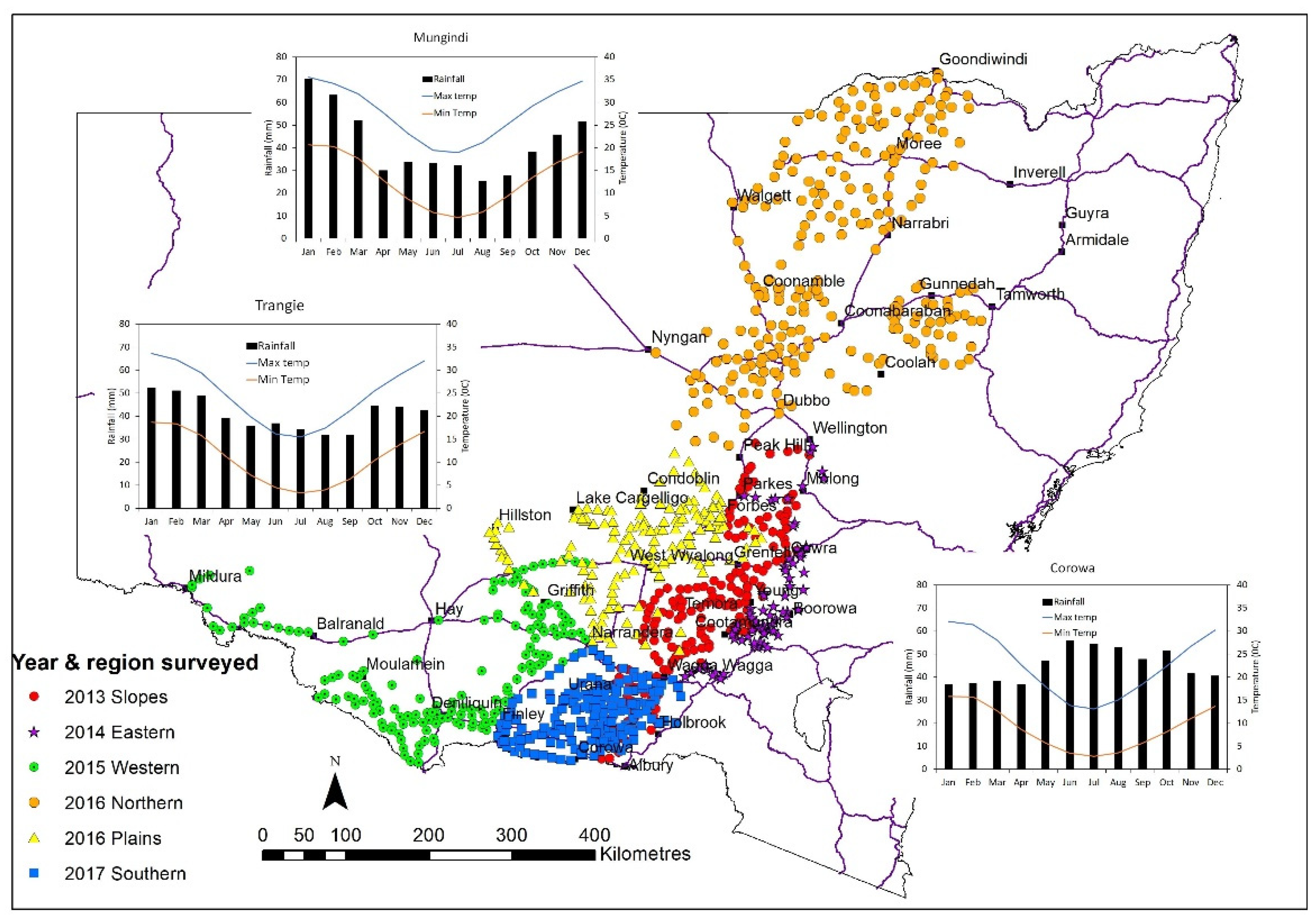
2.1. Random Surveys

Over the five-year period from 2013 to 2017, approximately 1000 cropping fields across New South Wales were surveyed at winter crop maturity (Nov. and Dec.) (Figure 1). In each year of the five-year survey period, 75 to 150 fields were surveyed, with greater numbers achieved in more expansive cropping regions. The surveyed fields were randomly selected at 10 km intervals, where possible, alternating between the left- and right-hand side of the road along a survey transect. The latitude and longitude coordinates of each survey site were recorded.

2.2. Data Collection

Weed surveys of each cropping field were performed by two people separately walking a ‘V’ shaped transect over an approximately 300-metre distance, with the crop species recorded and any encountered weed species being identified and recorded. The density of weeds in the sampling area was visually estimated using the categories adapted from Llewellyn and Powles [16]: very low (occasional plant), low (<1 plant m−2), medium (1–10 plants m−2), high (>10 plants m−2), and very high (>50 plants m−2 and dominating crop).
Wild oat populations found during NSW field surveys were frequently a complex of two or more species, with onsite identification being difficult [17]; samples were collected as Avena spp. and were subsequently and accurately identified by examining the seed.

2.3. Data Analysis

Survey data were firstly collated to determine the regional and statewide occurrence of the various crop and weed species identified as well as to determine if there were any specific associations between the 11 most frequently recorded weed species plus wild radish and the commonly occurring crops, wheat, barley, oats, canola, and pulse crops. To assess their combined presence or absence, 2 × 2 chi-square contingency tables were developed. These enable the comparison of observed counts with the expected counts as determined from a theoretical expectation. If there are no associations, then the observed numbers are similar to the expected numbers.
The data were analysed using chi-square goodness of fit tests, with the expected number of each pairing determined by the formula % of species A overall (presence or absence) × % of species B overall (presence or absence) × 996 (overall number of fields). Any pairings in which the expected number for one of the four combinations (both present (YY), species A present but not B (YN), species B present but not A (NY), or neither present (NN)) was five or below were removed from the analyses.
To determine if there were differences in species prevalence between the individual surveys and the overall NSW findings, the data were analysed using an exact test of goodness of fit [18] with the prevalence recorded in the overall NSW findings to determine the expected numbers for each species in each individual survey.

3. Results

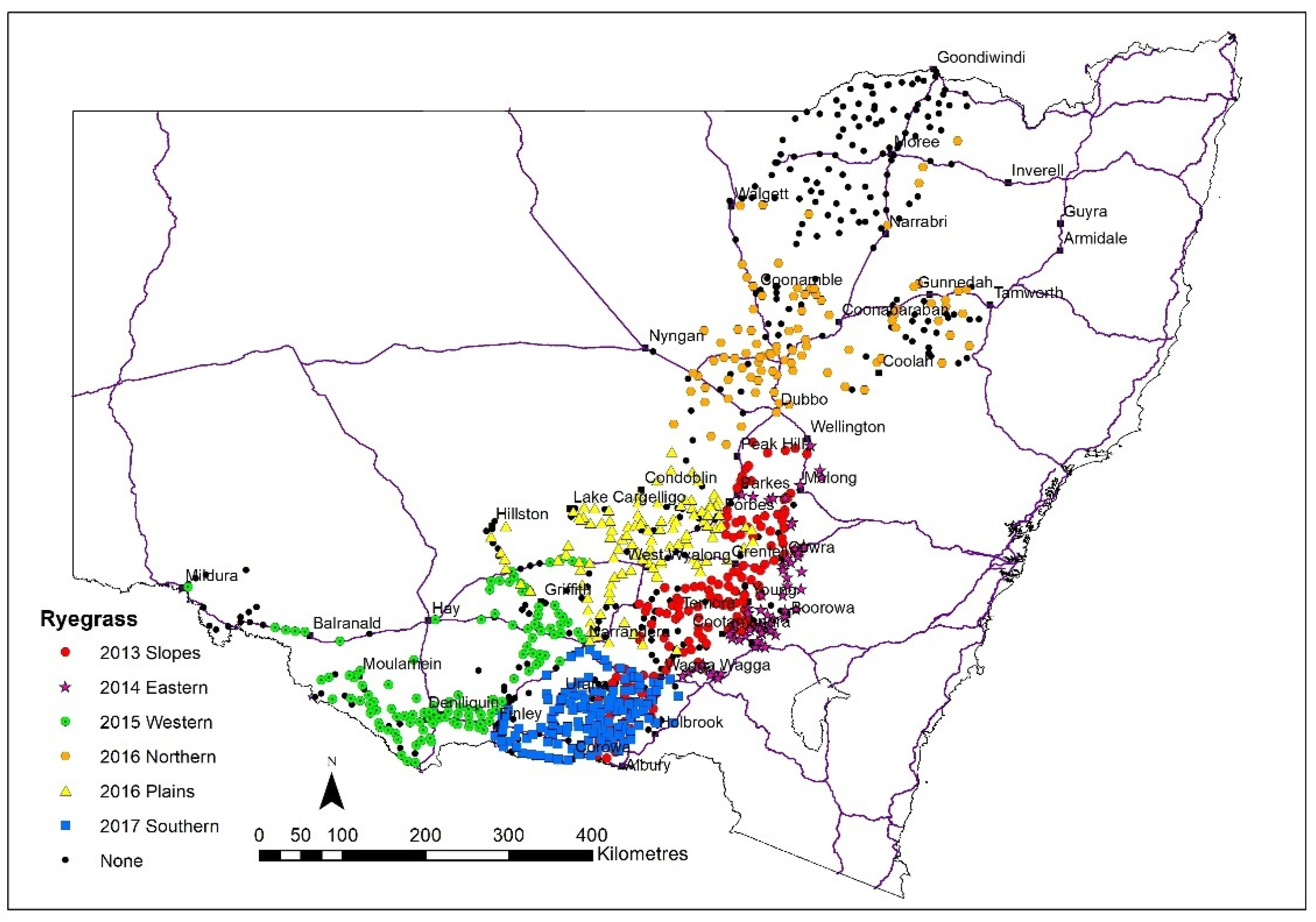
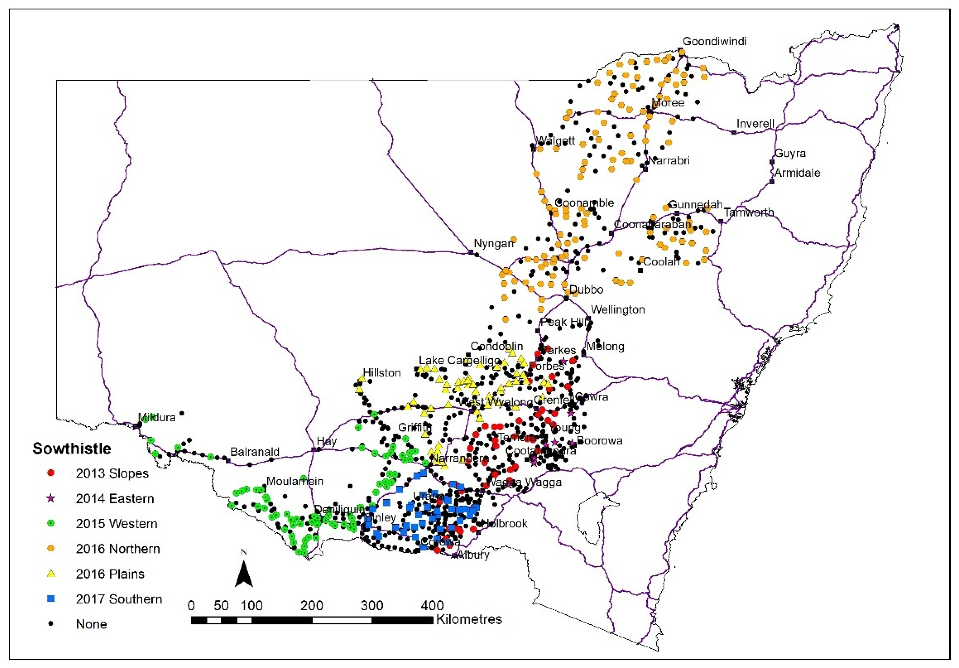
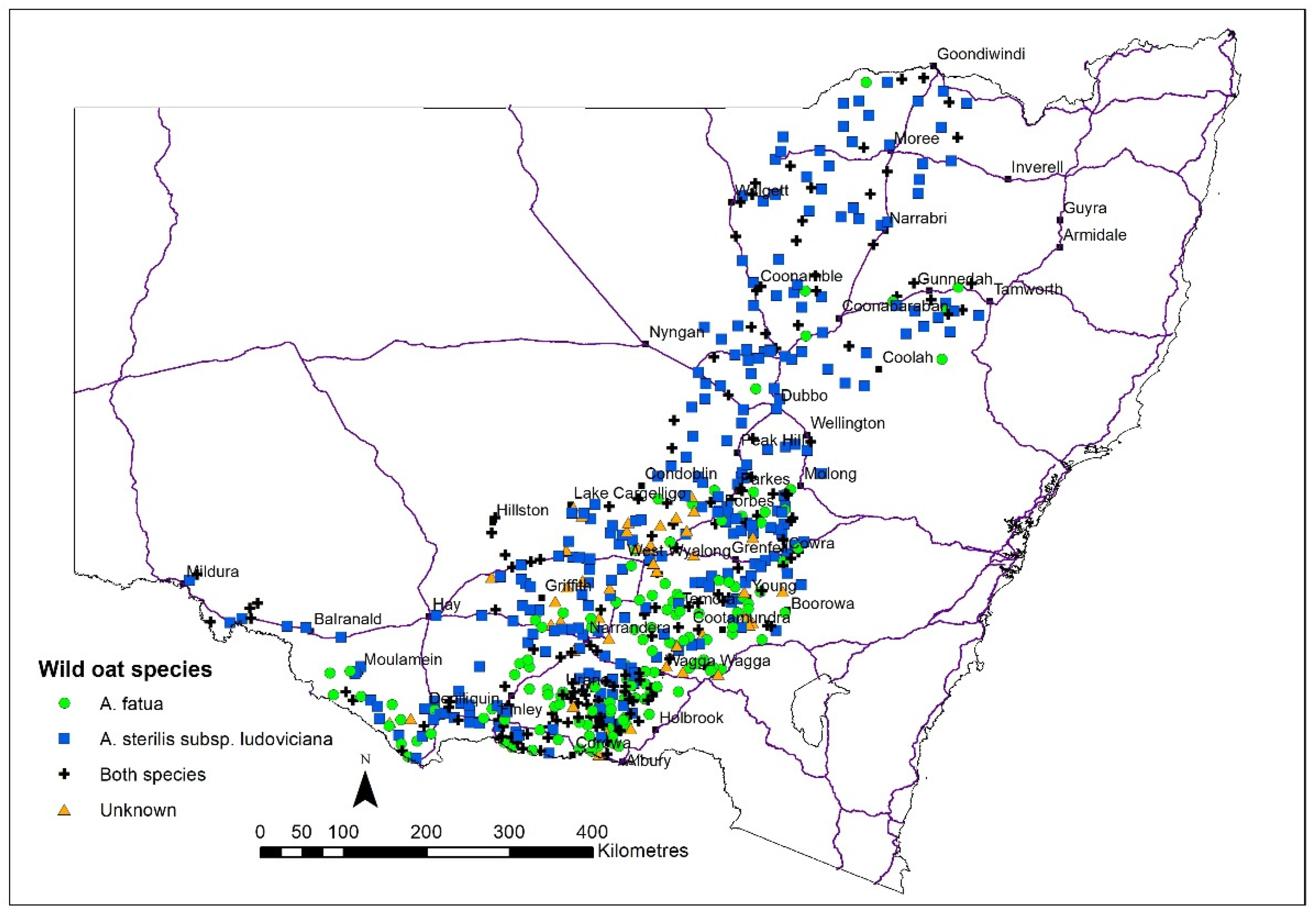
3.1. Occurrence and Density of Major Weed Species

Extensive random field surveys conducted at winter grain crop maturity at the end of the 2013 to 2017 growing seasons determined that the occurrence for annual ryegrass (69% of fields), wild oats (60%), and sowthistle (34%) was markedly higher than any of the other observed weed species (Table 1). Annual ryegrass was particularly prevalent in the southern and eastern cropping regions, where it was present in over 80% of surveyed fields—higher than the average frequency in NSW (p < 0.01) (Table 2, Figure 2). In contrast, the occurrence of this weed was lower (p < 0.01) in the northern region, where it was found in only 38% of fields and predominantly in the southern half of this region (Table 2).
Wild oats, although typically occurring at much lower frequencies than annual ryegrass, were more evenly distributed across the NSW cropping region, consistently occurring in 50 to 70% of fields in all regions (Figure 3). However, wild oats were only present at an above-average frequency of cropping fields in the southern region (p < 0.01) (Table 2). Although occurring throughout all regions, sowthistle populations were more common (p < 0.05) in warmer regions (i.e., northern and western) and less common (p < 0.01) in the eastern region (Figure 4). Confirming the dominance of these three species, the next most commonly occurring species, barley grass (Hordeum spp.) and wireweed (Polygonum aviculare L.), were present in up to 50% fewer fields (Table 1).
Of the two wild oat species (A. sterilis subsp. ludoviciana (Durieu) M.Gillet & Magne and A. fatua L.) recorded during random field surveys of NSW cropping regions, A. sterilis subsp. ludoviciana was the most prevalent, comprising 75% of recorded populations. A. fatua was present in 55% of populations, with 29% of wild oat populations containing both these species. A. sterilis subsp. ludoviciana was more prevalent in the north and northwest regions while A. fatua was more commonly occurring in the south and central NSW cropping regions. A. fatua was found in 80% or more of fields in the southern and eastern regions and A. sterilis subsp. ludoviciana was collected in more than 70% of fields in the western and plains regions, as well as in over 90% in the northern region. The southern region had the highest proportion (47%) of populations containing both species (Figure 5).
Winter annual weeds were consistently present at low (<1.0 plants m−2) to very low (<1.0 plants 10m−2) plant densities in NSW cropping region fields at winter crop maturity. There were 3271 weed infestations recorded in 996 fields surveyed across the six regions from 2013 to 2017, and approximately nearly half (49%) were recorded at a very low density (Table 3). Among the five most common species, only ryegrass (59.7%) had less than 75% of populations recorded at low or very low densities (<1 plant m−2) (Table 3). Less than 2% of infestations (50) were found at a very high level (>50 plants m−2); moreover, of these, the majority (36) were annual ryegrass (Table 3). The other species which were recorded as having very high levels of infestation included wild oats, barley grass, brome grass, phalaris (Phalaris spp.), toad rush (Juncus bufonius L.), silver grass (Vulpia spp.), and rough poppy (Papaver hybridum L.).

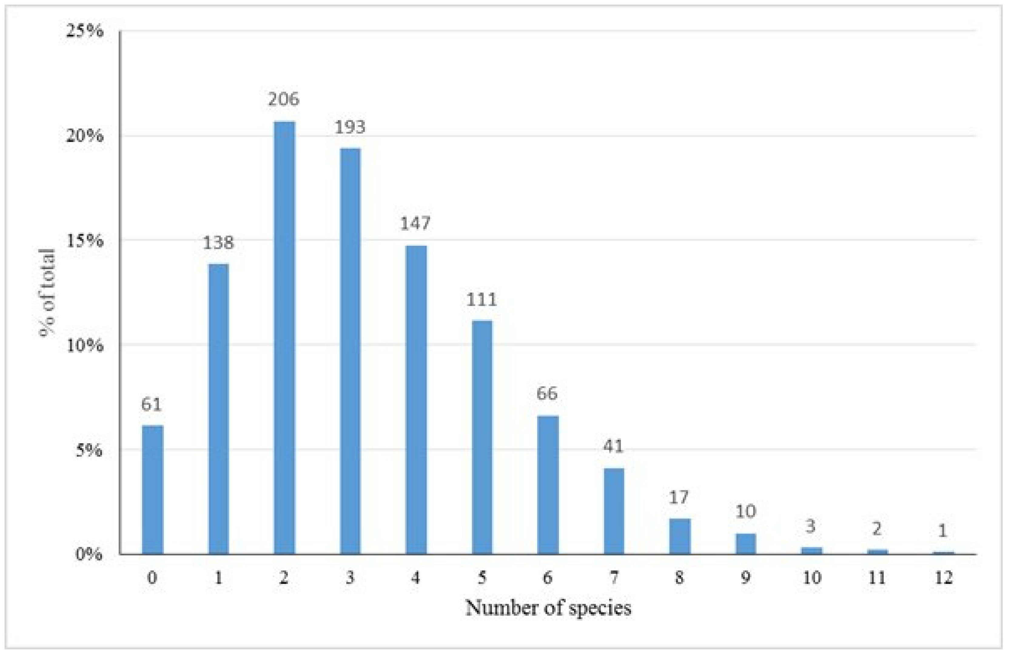
3.2. Weed Species Diversity and Associations

Across the 996 fields, there were 3271 occurrences of weeds from 65 species (Table S1) recorded with an average of 3.3 species per field. These species were from 20 families and 57 genera, although 15 were classified only as a group of species within the genus. In 61 of the fields (6%), no weeds were recorded; however, most commonly, two (21%), three (20%), or four (19%) weed species were recorded (Figure 6). While one field contained 12 different species, only 7% (74 fields) had more than six species present.
The comparison of occurrence patterns of weed species recorded during surveys found that grass weeds were most commonly occurring with other grass weed species and that, similarly, broadleaf weeds were more often found occurring with other broadleaf weed species. The chi-square analysis of 61 pairings of 12 weed species determined that there were five pairings that were well above (>10%) expected occurrence (Table 4). Three of these pairings were both grasses, which included annual ryegrass (ryegrass:wild oats, 18%, p < 0.0001; ryegrass:silver grass, 13%, p = 0.0008; ryegrass:brome grass, 13%, p = 0.0025), and two were of broadleaf species, which both included sowthistle (sowthistle:prickly lettuce (Lactuca serriola L.), 19%, p < 0.0001; sowthistle:fleabane (Conyza spp.) 14%, p < 0.0001 (Table 4). Another seven pairings had increases of between 5% and 10%, three grass pairs (brome grass (Bromus spp.):wild oats, 8%, p = 0.171; barley grass:brome grass, 7%, p = 0.0017; barley grass:silver grass, 7%, p = 0.0005), three broadleaf (sowthistle:wireweed, 9.7%, p = 0.0039; fleabane:prickly lettuce, 6%, p = 0.0011; fleabane:wireweed, 5.2%, p = 0.012) and one grass and broadleaf pairing (wild oats:sowthistle, 7%, p < 0.493) (Table 4). Another two pairings, both a grass and broadleaf (ryegrass:sowthistle, −9%, p = 0.215; ryegrass:fleabane, −9%, p = 0.271), were between 5 and 10% less likely to be both present or absent from the field, while no species pairings were more than 10% less likely (Table 4).

3.3. Crop Species

Wheat was the most common crop across the NSW cropping region during the 2013–17 surveys. From a total of 996 fields visited across the six regions, most of the fields were wheat crops (slopes 87%; eastern 64%; western 54%; plains 65%; northern 46%; southern 59%), with barley, canola, and oats comprising the next most commonly visited (Table 5). Barley was more prevalent in the northern, western, and plains regions, with oats more common in the southern region. Ninety-three pulse (chick peas, lupins, field peas, faba beans, and broad beans) crops were visited, with the majority (49) of them being chick peas in the northern region. Forty-one improved pasture fields were visited, while the remaining fields were triticale (7), linseed (1), wheat (6), or barley (2) undersown with a perennial pasture species. Pasture fields or fields with a crop undersown with a pasture species comprised 20% of the fields visited in the eastern region (Table 1).
There was a large number of crop:weed pairings for which the observed number differed markedly from what was expected (Table 6). For many of these, there were low expected crop and weed pairings and, therefore, while differences were often large, as percentage difference, they were not statistically significant. Of the thirteen pairings expected to be found together in more than 50 fields, five had increases in observed numbers relative to the expected value greater than 5%, and all of these were grass weeds in cereal crops (barley:wild oats, 16% p = 0.133; wheat:brome grass, 9% p = 0.606; wheat:ryegrass, 7% p = 0.005; wheat:silver grass, 7% p = 0.787; wheat:wild oats, 6% p = 0.035). Six others had decreases in the observed numbers relative to the expected value of greater than 5%, and these four were broadleaf weeds in wheat crops (wheat:sowthistle, −12% p = 0.0052; wheat:wire weed, −11% p = 0.355; wheat:prickly lettuce, −11% p = 0.411; wheat:fleabane, −9% p = 0.59); moreover, two were grass weeds in pulse crops (ryegrass, −57% p < 0.0001; wild oats, −37% p = 0.0002).

4. Discussion

Annual ryegrass, wild oats, and sowthistle were the most prevalent species in surveys of NSW cropping fields, confirming that these species are currently the most problematic weeds of regional grain production systems. Previous surveys of NSW cropping regions have also identified the occurrence of these species; however, it is apparent from the results presented here that they are becoming increasingly problematic [10,19]. Two previous surveys of these cropping regions (slopes, plains, and southern) similarly identified annual ryegrass and wild oats as the dominant weeds [13,14,20]. Only one of the previously surveyed regions (plains and the western part of southern region) recorded broadleaf weed species, identifying sowthistle as the most common broadleaf weed species and the third most common species overall [20].
Prior to these surveys, in 1996, Lemerle et al. [10] reported that annual ryegrass was less common than both capeweed (Arctotheca calendula) and wild oats in an area similar to that of the slopes survey. Earlier, Taylor and Lill [19] found that skeleton weed (Chondrilla juncea L.) was the most common species, present in 35% of 161 fields in southern NSW (portions of the southern and western survey regions) between 1967 and 1970, with wild oats (27%) and capeweed (19%) being less prevalent. However, a grouping of ‘grasses other than wild oats’, which included annual ryegrass, barley grass, silver grass, and others, was present in 50% of fields. In both of these surveys [10,19], sowthistle was ranked much lower than in the later surveys, with Lemerle et al. [10] recording this weed in only 10.5% of fields (=20th) and agronomists ranking it much lower as a current and future problem, while Taylor and Lill [19] recorded the occurrence of this species in the ‘other weeds’ category.
Changes in the importance of weed species between surveys, albeit over a longer time period, have also been reported in Canada, where some species (bluebur (Lappula squarrosa (Retz.) Dumort); wild mustard (Sinapis arvensis L.)) have declined in their occurrence and others have increased (cleavers (Galium aparine L.); Kochia (Kochia scoparia (L.) Schrad.)), while some have remained relatively consistent in importance (wild oats: Canada thistle (Cirsium arvense (L.) Scop.)) [21]. Differences in the distribution of weed species were noted with the increased adoption of reduced tillage, with small seeded species such as black grass (Alopecurus myosuroides Huds.) in England and dandelion (Taraxacum officinale G.H. Weber ex Wiggers) and sowthistle in Argentina becoming more prevalent [22,23].
The findings of the present survey highlight the increasing significance of annual ryegrass as an important weed of NSW cropping systems. During this time, sheep production in NSW has waned as a consequence of an increased focus on grain production [24,25]. With annual ryegrass often forming a major component of improved pastures, it has since become a major weed of cropping system and is now widespread and naturalised across this region as it is both highly competitive and highly fecund [26,27,28]. Since the Taylor and Lill (1986) survey, there has been widespread adoption of conservation cropping, which is accompanied with an increased reliance on herbicides [29,30]. Being an outcrossing species [28], annual ryegrass exhibits greater genetic variability than many other weed species, resulting in more rapid herbicide resistance evolution when compared with other species [13,14,31,32], with significant levels of resistance in this species in all regions. These factors have thus all contributed to the increased importance of annual ryegrass as a weed of cropping systems in New South Wales.
While wild oats and sowthistle do not exhibit similar high frequencies of herbicide resistance as annual ryegrass [15,33], a significant proportion of populations are resistant. The level of resistance will increase with current production practices, especially as many of the non-chemical control methods used to manage herbicide resistant annual ryegrass populations, such as harvest weed seed control, are less successful in these weed species [34].
The finding that, while both wild oat species are found across NSW, A. sterilis subsp. ludoviciana is more prevalent to the north and A. fatua to the south (Figure 5), is consistent with the literature [35,36] and previous surveys [13,31]. Quail and Carter [36] reported that this was due to respective differences in germination patterns being more suited to regional differences in winter crop planting times. However, changes in species distribution due to changing seasonal conditions is likely. Due to differences in the optimum temperature for germination, a greater proportion of A. fatua emerge in autumn than A. sterilis subsp. ludoviciana [36]. Therefore, in years with a shorter growing season, A. fatua plants may set more seed and dominate mixed populations as reported by Broster [37]. The opposite may, also potentially occur in years more favourable to A. sterilis subsp. ludoviciana.
The positive associations between crop and weed species (Table 6) provide evidence of the difficulty in controlling grass weeds in cereal and broadleaf weeds in pulse and oilseed crops with grass weeds more commonly occurring in cereal crops, while broadleaf weeds were more frequently recorded in canola and pulse crops. Even though pulse crops are reported to be less competitive with weeds, [38] all five grass species analysed were less likely than expected to be found in pulse crops (barley grass, −94% p = 0.0003; brome grass, −75% p = 0.036; ryegrass, −57% p < 0.0001; silver grass, −100% p = 0.0064; wild oats, −37% p = 0.0002). Similarly, of the 12 weed species pairings that showed an increase in their association of more than 5%, six consisted of two grass species and five consisted of both broadleaf species, with there was only one grass and broadleaf pairing. These co-occurrences reflect the difficulty in controlling weeds in similar crop types, especially given widespread herbicide resistance to in-crop selective herbicides [32,39,40,41].
The negative associations of below −5% observed between weed species can also be partly attributed to regional differences in weed dispersal. For example, both fleabane and sowthistle were found more often in the northern areas (p < 0.0001) of the survey regions, while annual ryegrass (p < 0.0001) was more common in the southern areas (Table 1 and Table 2, Figure 2 and Figure 4). In contrast, wild oats were the most common grass species in the northern area and was also more commonly found co-occurring with sowthistle and were the only grass and broadleaf pairing with an increase together of greater than 5%.
Twelve fields (1.2%) contained all five grass weed species, and 47 (4.7%) contained four of the five species. Of these 59 fields, 47 were cereal crops (46 wheat; 1 oat), further emphasising the difficulty in controlling grass weeds in cereal crops; moreover, the remaining 12 fields were all pastures, either annual or perennial, in which it is likely that no herbicides had been applied that year. The significant difference in grass weed control obtained between cereal and broadleaf crops such as canola or pulses was also observed.

5. Conclusions

Long-term regional surveys performed across NSW identified that the dominant weed species in cropping fields were annual ryegrass, wild oats, and sowthistle, and that each present in over one-third of surveyed fields (Table 1). Annual ryegrass was the most dominant, occurring in over 65% of NSW cropping fields. The increasing prevalence of ryegrass is further compounded by the focus on cereal crop production, especially wheat, the most commonly grown crop across NSW providing the least opportunity to manage grass weeds, as shown by this research in the higher-than-expected occurrence of annual ryegrass and wild oats in wheat crops.
While rotating to broadleaf crops (canola or pulses) can increase options for ryegrass and wild oat control, our findings showed that this resulted in increases in the number of fields containing sowthistle (canola:sowthistle, 63% p = 0.548; pulse:sowthistle, 94% p < 0.0001). Additionally, sowthistle can germinate and grow during the summer fallow period, and the reduced competition during this period can result in high sowthistle seed production with equivalent large increases in the weed seedbank. Information gained from undertaking long-term weed species surveillance is of great importance to the agricultural industry and will also promote the development of targeted weed research programs for the NSW cropping industry.

Supplementary Materials

The following supporting information can be downloaded at: https://www.mdpi.com/article/10.3390/agronomy12122914/s1, Table S1: Weed species recorded across surveys.

Author Contributions

Conceptualization, J.C.B.; methodology and investigation, J.C.B. and A.J.C.; data curation, J.C.B.; writing—original draft preparation, J.C.B.; writing—review and editing, J.C.B., A.J.C., L.A.W., M.J.W.; funding acquisition, J.C.B., L.A.W. and M.J.W. All authors have read and agreed to the published version of the manuscript.

Funding

This research was funded by the Grains Research and Development Corporation grant numbers UCS00020 and US00084. The GRDC had no involvement in study design, collection, analysis or interpretation of data, or in writing the manuscript.

Data Availability Statement

The data that support this study are available in the article and upon request to the corresponding author.

Acknowledgments

The authors would like to acknowledge numerous casual staff and students of Charles Sturt University for their technical assistance in conducting the surveys and species identification.

Conflicts of Interest

The authors declare no conflict of interest.

References

  1. Oerke, E.C. Crop losses to pests. J. Agric. Sci. 2006, 144, 31–43. [Google Scholar] [CrossRef]
  2. McLeod, R. Annual Costs of Weeds in Australia; eSYS Development Pty Limited. Published by the Centre for Invasive Species Solutions: Canberra, Australia, 2018. [Google Scholar]
  3. Llewellyn, R.S.; Ronning, D.; Ouzman, J.; Walker, S.R.; Mayfield, A.; Clarke, M. Impact of Weeds on Australian Grain Production: The Cost of Weeds to Australian Grain Growers and the Adoption of Weed Management and Tillage Practices; CSIRO: Canberra, Australia, 2016. [Google Scholar]
  4. ABARES. Australian Commodity Statistics. Available online: http://www.daff.gov.au/abares (accessed on 18 March 2021).
  5. NSW Department of Planning Industry and Environment. Digital Soil Mapping of Key Soil Properties over NSW; Technical Report; NSW OEH: Sydney, NSW, Australia, 2018.
  6. NSW Department of Planning Industry and Environment. Australian Soil Classification (ASC) Soil Type map of NSW, Version 4.5. Available online: https://datasets.seed.nsw.gov.au/dataset/australian-soil-classification-asc-soil-type-map-of-nsweaa10 (accessed on 21 October 2021).
  7. Barson, M. Land Management Practice Trends in New South Wales and the Australian Capital Territory’s Broadacre Cropping Industries. Caring for Our Country Sustainable Practices Fact Sheet 8; Department of Agriculture, Fisheries and Forestry: Canberra, Australia, 2012.
  8. Australian Bureau of Statistics. Land Management and Farming in Australia. Available online: https://www.abs.gov.au/statistics/industry/agriculture/land-management-and-farming-australia/latest-release (accessed on 21 October 2021).
  9. Bureau of Meteorology. Bureau of Meteorology Weather and Climate Statistics. Available online: http://www.bom.gov.au (accessed on 6 September 2021).
  10. Lemerle, D.; Tang, H.; Murray, G.; Morris, S. Survey of weeds and diseases in cereal crops in the southern wheat belt of New South Wales. Aust. J. Exp. Agric. 1996, 36, 545–554. [Google Scholar] [CrossRef]
  11. Osten, V.A.; Walker, S.R.; Storrie, A.; Widderick, M.; Moylan, P.; Robinson, G.R.; Galea, K. Survey of weed flora and management relative to cropping practices in the north-eastern grain region of Australia. Aust. J. Exp. Agric. 2007, 47, 57–70. [Google Scholar] [CrossRef]
  12. D’Emden, F.H.; Llewellyn, R.S.; Burton, M.P. Adoption of conservation tillage in Australian cropping regions: An application of duration analysis. Technol. Forecast. Soc. Change 2006, 73, 630–647. [Google Scholar] [CrossRef]
  13. Broster, J.C.; Koetz, E.A.; Wu, H. Herbicide resistance in wild oats (Avena spp.) in southern New South Wales. Plant Prot. Q. 2011, 26, 106–110. [Google Scholar]
  14. Broster, J.C.; Koetz, E.A.; Wu, H. Herbicide resistance levels in annual ryegrass (Lolium rigidum Gaud.) in southern New South Wales. Plant Prot. Q. 2011, 26, 22–28. [Google Scholar]
  15. Broster, J.C.; Koetz, E.A.; Shephard, A.J.; Wu, H. Extent of herbicide resistance in three broadleaf weed species in southern New South Wales. In Proceedings of the 19th Australasian Weeds Conference, Hobart, Australia, 1–4 September 2014; pp. 282–285. [Google Scholar]
  16. Llewellyn, R.S.; Powles, S.B. High levels of herbicide resistance in rigid ryegrass (Lolium rigidum) in the wheat belt of Western Australia. Weed Technol. 2001, 15, 242–248. [Google Scholar] [CrossRef]
  17. Cartledge, O. Wild oats. Queensl. Agric. J. 1973, 99, 58–61. [Google Scholar]
  18. McDonald, J. Handbook of Biological Statistics, 3rd ed.; Sparky House Publishing: Baltimore, MD, USA, 2014; p. 299. [Google Scholar]
  19. Taylor, A.C.; Lill, W.J. Wheat crop surveys in southern New South Wales. 4. The response by grain yield and other wheat attributes to weeds. Aust. J. Exp. Agric. 1986, 26, 709–715. [Google Scholar] [CrossRef]
  20. Broster, J.C.; Koetz, E.A.; Wu, H. Weed species present in cereal crops in southern New South Wales. In Proceedings of the 18th Australasian Weeds Conference, Melbourne, VIC, Australia, 8–11 October 2012; pp. 241–244. [Google Scholar]
  21. Thomas, A.G.; Leeson, J.Y. Tracking long-term changes in the arable weed flora of Canada. In Invasive Plants: Inventories, Strategies and Action. Topics in Canadian Weed Science, Volume 5; Clements, D.R., Darbyshire, S.J., Eds.; Canadian Weed Science Society—Société Canadienne de Malherbologie: Sainte Anne de Bellevue, QC, Canada, 2007; pp. 43–69. [Google Scholar]
  22. Froud-Williams, R.J.; Drennan, D.S.H.; Chancellor, R.J. Influence of cultivation regime on weed floras of arable cropping systems. J. Appl. Ecol. 1983, 20, 187–197. [Google Scholar] [CrossRef]
  23. Scursoni, J.A.; Gigón, R.; Martín, A.N.; Vigna, M.R.; Leguizamón, E.S.; Istilart, C.; López, R. Changes in weed communities of spring wheat crops of Buenos Aires Province of Argentina. Weed Sci. 2014, 62, 51–62. [Google Scholar] [CrossRef]
  24. Henzell, T. Australian Agriculture: Its History and Challenges; CSIRO Publishing: Collingwood, Australia, 2007. [Google Scholar]
  25. Goggin, D.E.; Powles, S.B.; Steadman, K.J. Understanding Lolium rigidum seeds: The key to managing a problem weed? Agronomy 2012, 2, 222–239. [Google Scholar] [CrossRef]
  26. Gill, G.S. Why annual ryegrass is a problem in Australian agriculture. Plant Prot. Q. 1996, 11, 193–195. [Google Scholar]
  27. Bajwa, A.A.; Latif, S.; Borger, C.; Iqbal, N.; Asaduzzaman, M.; Wu, H.; Walsh, M.J. The remarkable journey of a weed: Biology and management of annual ryegrass (Lolium rigidum) in conservation cropping systems of Australia. Plants 2021, 10, 1505. [Google Scholar] [CrossRef]
  28. Kloot, P.M. The genus Lolium in Australia. Aust. J. Bot. 1983, 31, 421–435. [Google Scholar] [CrossRef]
  29. Llewellyn, R.S.; D’Emden, F.H. Understanding the drivers of no-till adoption in Australian agriculture. In Landscapes Transformed: The Quiet Triumph of Conservation Tillage and Direct Seeding; University of Saskatchewan: Saskatoon, SK, Canada, 2009; pp. 70–79. [Google Scholar]
  30. D’Emden, F.H.; Llewellyn, R.S. No-till adoption and cropping issues for Australian grain growers. In Proceedings of the Fourth International Crop Science Conference, Brisbane, Australia, 26 September–1 October 2004; p. 108. [Google Scholar]
  31. Broster, J.C.; Koetz, E.A.; Wu, H. Herbicide resistance levels in annual ryegrass (Lolium rigidum Gaud.) and wild oats (Avena spp.) in south-western New South Wales. Plant Prot. Q. 2013, 28, 126–132. [Google Scholar]
  32. Broster, J.C.; Boutsalis, P.; Gill, G.S.; Preston, C. The extent of herbicide resistance in Lolium rigidum Gaud. (annual ryegrass) across south-eastern Australia as determined from random surveys. Crop Pasture Sci. 2022, 73, 1308–1317. [Google Scholar] [CrossRef]
  33. Broster, J.C.; Chambers, A.J.; Jalaludin, A.; Widderick, M.J.; Walsh, M.J. The extent of herbicide resistance in ryegrass and wild oats in New South Wales and Queensland. In Proceedings of the 21st Australasian Weeds Conference, Sydney, NSW, Australia, 9–13 September 2018; p. 145. [Google Scholar]
  34. Widderick, M.J.; Keenan, M.D.; Walsh, M.J. Harvest weed seed control: Is there a role in northern region farming systems? In Proceedings of the 19th Australasian Weeds Conference, Hobart, Australia, 1–4 September 2014; pp. 153–156. [Google Scholar]
  35. McNamara, D.W. The distribution of wild oat species in New South Wales. Agric. Gaz. 1966, 77, 761–763. [Google Scholar]
  36. Quail, P.H.; Carter, O.G. Survival and seasonal germination of seeds of Avena fatua and A. ludoviciana. Aust. J. Agric. Res. 1968, 19, 721–729. [Google Scholar] [CrossRef]
  37. Broster, J.C. Herbicide Resistance in Wild Oats in Southern New South Wales. Master’s Thesis, Charles Sturt University, Wagga Wagga, Australia, 1998. [Google Scholar]
  38. Lemerle, D.; Verbeek, B.; Coombes, N. Losses in grain yield of winter crops from Lolium rigidum competition depend on crop species, cultivar and season. Weed Res. 1995, 35, 503–509. [Google Scholar] [CrossRef]
  39. Owen, M.J.; Martinez, N.J.; Powles, S.B. Multiple herbicide-resistant wild radish (Raphanus raphanistrum) populations dominate Western Australian cropping fields. Crop Pasture Sci. 2015, 66, 1079–1085. [Google Scholar] [CrossRef]
  40. Owen, M.J.; Martinez, N.J.; Powles, S.B. Multiple herbicide-resistant Lolium rigidum (annual ryegrass) now dominates across the Western Australian grain belt. Weed Res. 2014, 54, 314–324. [Google Scholar] [CrossRef]
  41. Boutsalis, P.; Gill, G.S.; Preston, C. Incidence of herbicide resistance in rigid ryegrass (Lolium rigidum) across southeastern Australia. Weed Technol. 2012, 26, 391–398. [Google Scholar] [CrossRef]
Figure 1. Location of cropping fields surveyed in each of the New South Wales cropping regions during random weed seed collection surveys conducted at the end of each growing season from 2013 to 2017. Embedded line and bar graphs depict long-term (60+ years) monthly average rainfall and temperature data for three representative locations that indicate growing season differences across the cropping region [9]. Shape and colour of symbol denotes survey region and year.
Agronomy 12 02914 g001
Figure 2. Location of ryegrass (Lolium rigidum) in each of the New South Wales cropping regions during random weed seed collection surveys conducted at the end of each growing season from 2013 to 2017. Shape and colour of symbol denotes survey region and year.
Agronomy 12 02914 g002
Figure 3. Location of wild oats (Avena spp.) in each of the New South Wales cropping regions during random weed seed collection surveys conducted at the end of each growing season from 2013 to 2017. Shape and colour of symbol denotes survey region and year.
Agronomy 12 02914 g003
Figure 4. Location of sowthistle (Sonchus oleraceus) in each of the New South Wales cropping regions during random weed seed collection surveys conducted at the end of each growing season from 2013 to 2017. Shape and colour of symbol denotes survey region and year.
Agronomy 12 02914 g004
Figure 5. Distribution of A. fatua and A. sterilis subsp. ludoviciana in New South Wales during random weed seed collection surveys conducted at the end of each growing season from 2013 to 2017.
Agronomy 12 02914 g005
Figure 6. Proportion of fields (%) containing different numbers of weed species during random weed seed collection surveys conducted at the end of each growing season from 2013 to 2017 (number above columns indicates number of fields).
Agronomy 12 02914 g006
Table 1. Ten most commonly observed winter annual weed species of the NSW cropping regions as recorded at winter crop harvest during annual random surveys conducted over a five-year period, 2013 to 2017 (number in brackets represent percentage of occurrence in surveyed fields) (Scientific names can be found in Table S1).
Occurrence RankingNSW 2013 to 2017Slopes 2013Eastern 2014Western 2015Plains 2016Northern 2016Southern 2017
1Ryegrass
(68.5)
Ryegrass
(81.9)
Ryegrass
(86.7)
Ryegrass
(72.0)
Ryegrass
(74.3)
Wild oats
(53.3)
Ryegrass
(81.5)
2Wild oats
(59.9)
Wild oats
(67.8)
Wild oats
(50.7)
Wild oats
(59.1)
Wild oats
(57.2)
Sow thistle
(48.8)
Wild oats
(67.9)
3Sow thistle
(34.2)
Barley grass
(24.6)
Barley grass
(16.0)
Sow thistle
(43.9)
Sow thistle
(36.8)
Ryegrass
(37.7)
Sow thistle
(25.3)
4Barley grass
(17.0)
Brome grass
(23.6)
Brome grass
(16.0)
Barley grass
(36.6)
Prickly lettuce
(23.0)
Fleabane
(22.1)
Brome grass
(13.6)
5Wireweed
(15.4)
Sow thistle
(22.6)
Silver grass
(16.0)
Wireweed
(28.7)
Silver grass
(20.4)
Wireweed
(20.1)
Barley grass
(8.6)
6Prickly lettuce
(13.8)
Silver grass
(19.6)
Sow thistle
(10.7)
Brome grass
(19.5)
Fleabane
(17.1)
Wild turnip
(18.9)
Wireweed
(8.6)
7Brome grass
(13.0)
Prickly lettuce
(14.6)
Shepherd’s purse
(9.3)
IHM*
(18.3)
Toad rush
(16.4)
Prickly lettuce
(14.3)
Silver grass
(7.4)
8Fleabane
(12.4)
Wireweed
(10.6)
Wild radish
(9.3)
Fleabane
(15.2)
Skeleton weed
(13.8)
Bluebell
(10.2)
Wild radish
(7.4)
9Silver grass
(11.3)
Skeleton weed
(6.5)
Prickly lettuce
(6.7)
Prickly lettuce
(14.0)
Wireweed
(12.5)
Phalaris
(9.8)
Fleabane
(7.4)
10Skeleton weed,
IHM *
(5.4)
Mallow
(4.0)
Wireweed
(5.3)
Phalaris
(12.8)
IHM *, Paterson’s curse, Cudweed
(11.8)
Chloris spp., Cudweed
(9.0)
Prickly lettuce
(6.8)
* IHM = Indian hedge mustard.
Table 2. p value (exact test of goodness of fit) for 12 most common species, comparing incidence for each region to average across NSW (bold indicates increase, italics indicates decrease; ** insufficient expected incidence for analysis) (scientific names can be found in Table S1).
SlopesEasternWesternPlainsNorthernSouthern
Ryegrass<0.00010.00030.40.138<0.00010.0002
Wild oats0.0250.1250.88740.5090.037<0.0001
Sowthistle0.0004<0.00010.0110.442<0.00010.016
Barley grass0.0061.0<0.00010.031<0.00010.00323
Wireweed0.0620.01<0.00010.3690.0520.016
Prickly lettuce0.7590.0920.910.00220.8530.0062
Brome grass<0.00010.4990.020.015<0.00010.816
Fleabane<0.00010.00120.2850.084<0.00010.056
Silver grass0.00070.20.1370.0007<0.00010.136
Skeleton weed0.433**0.728<0.00010.00630.727
IHM *0.028**<0.00010.00620.00150.226
Wild radish0.859**0.0510.8380.8730.049
* IHM = Indian hedge mustard.
Table 3. Density of three most commonly occurring weed species recorded during random surveys of NSW cropping regions conducted at the end of each growing season from 2013 to 2017.
SpeciesPopulation DensityTotal
Populations
<1 10m−2<1 m−21–10 m−2>10 m−2>50 m−2
Proportion of Populations (%)
Ryegrass33.426.421.513.55.3683
Wild oats43.733.816.15.50.8597
Sow thistle59.830.88.21.20341
All species48.529.015.25.81.53271
Table 4. Relationships between grass and broadleaf weed species for 12 weed species investigated (four broadleaf/broadleaf and one grass/broadleaf combination excluded as the expected number for any combination was five or below).
Difference from Expected (YY * and NN * Combined)
Species 1Species 2>10%5% to 10%0% to 5%0% to −5%−5% to −10%>−10%
GrassGrass333100
BroadleafBroadleaf238400
GrassBroadleaf01171420
* YY = both species present; NN both species absent.
Table 5. Frequency of crop species occurrence in fields of New South Wales cropping regions during random weed seed collection surveys conducted at the end of each growing season from 2013 to 2017 (undersown indicates cereal crop with an accompanying perennial pasture species).
Slopes
2013
Eastern
2014
Western
2015
Plains
2016
Northern
2016
Southern
2017
NSW
Total
Wheat86.964.054.365.145.959.361.9
Barley7.01.317.715.818.45.612.2
Canola0.56.76.73.91.617.95.6
Oats0.54.06.18.66.65.65.2
Pulse4.02.76.71.325.83.79.2
Pasture0.012.08.54.60.85.64.1
Undersown0.08.00.00.00.01.20.8
Other1.01.30.00.70.81.20.8
Total19975164152244162996
Table 6. Relationships between grass and broadleaf crop and weed species for the 12 weed species (four cereal/broadleaf and five broadleaf/broadleaf combinations excluded as the expected number for any combination was five or below).
Difference from Expected (YY * Only)
CropWeed>
50%
25% to 50%0% to 25%0% to
−25%
−25% to
−50%
>
−50%
CerealGrass216600
BroadleafBroadleaf500211
CerealBroadleaf125720
BroadleafGrass000127
* YY = both species present.
Publisher’s Note: MDPI stays neutral with regard to jurisdictional claims in published maps and institutional affiliations.

