The Performance of Airborne C-Band PolInSAR Data on Forest Growth Stage Types Classification


Abstract
:1. Introduction
2. Test Site and Dataset
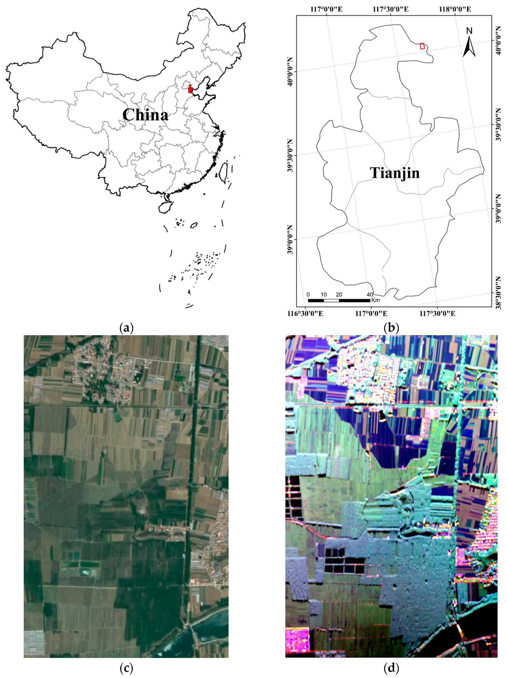
2.1. Test Site Description
2.2. Remote Sensing Data
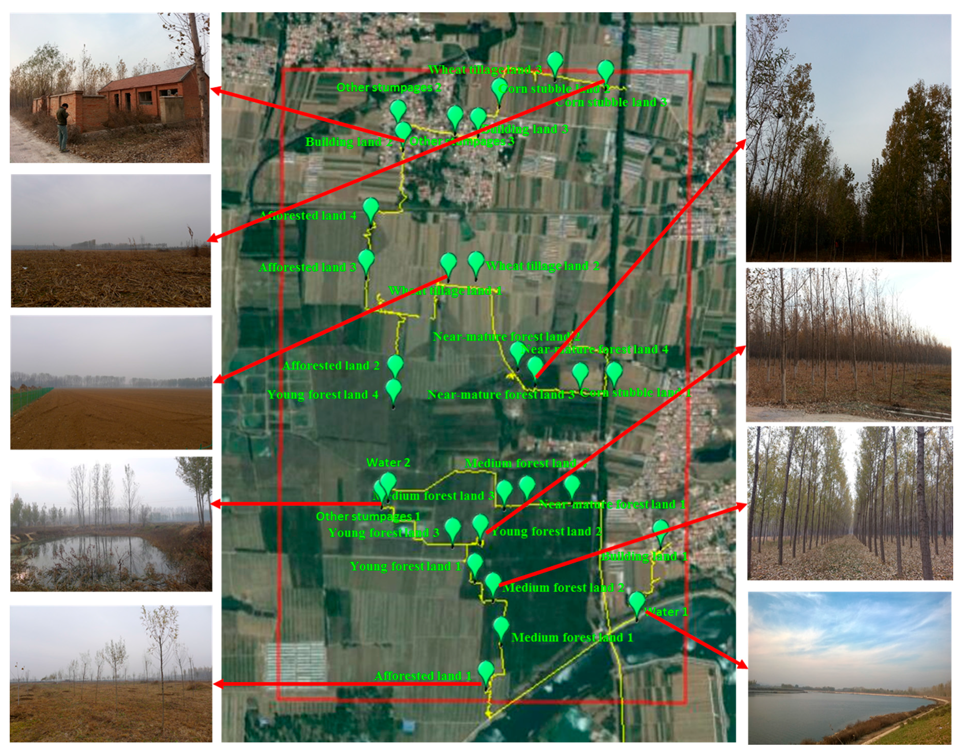
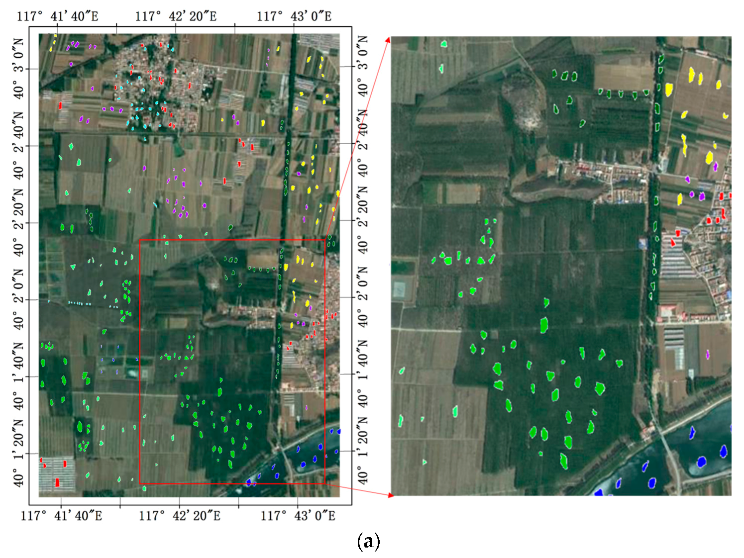
2.3. Ground Truth Data
3. Methods
3.1. PolSAR Data Processing
3.1.1. Polarimetric Information Extraction
3.1.2. RK Texture Information Extraction
3.1.3. Coherence Information Extraction
3.2. SVM Classification Method
4. Results
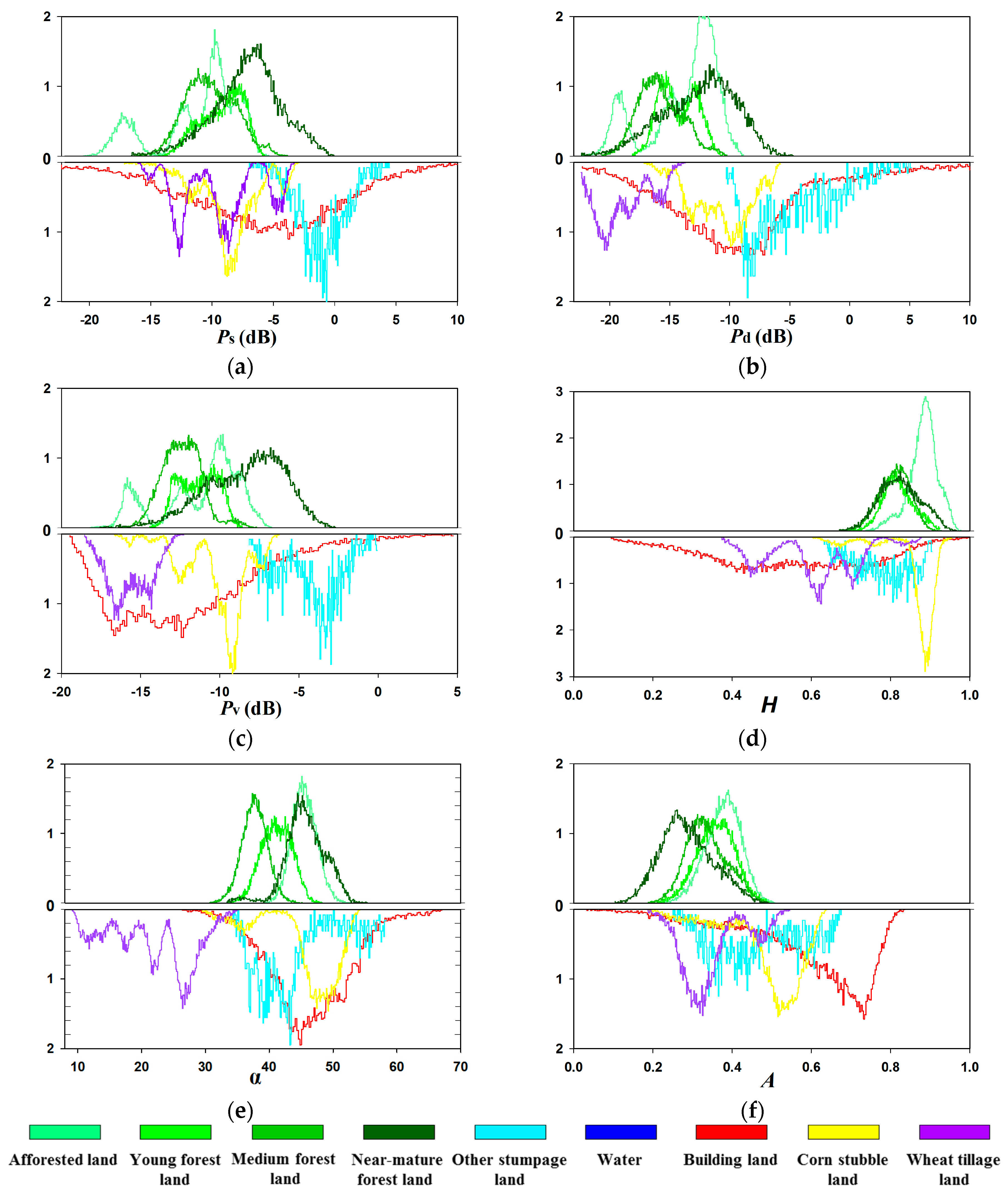
4.1. Capabilities of Classification Features
4.1.1. Polarization Feature
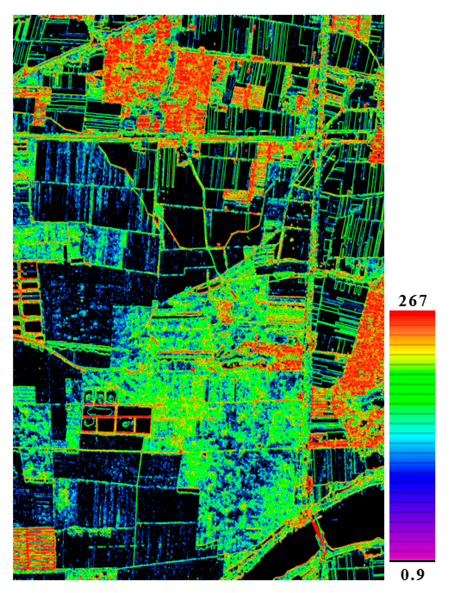
4.1.2. Texture
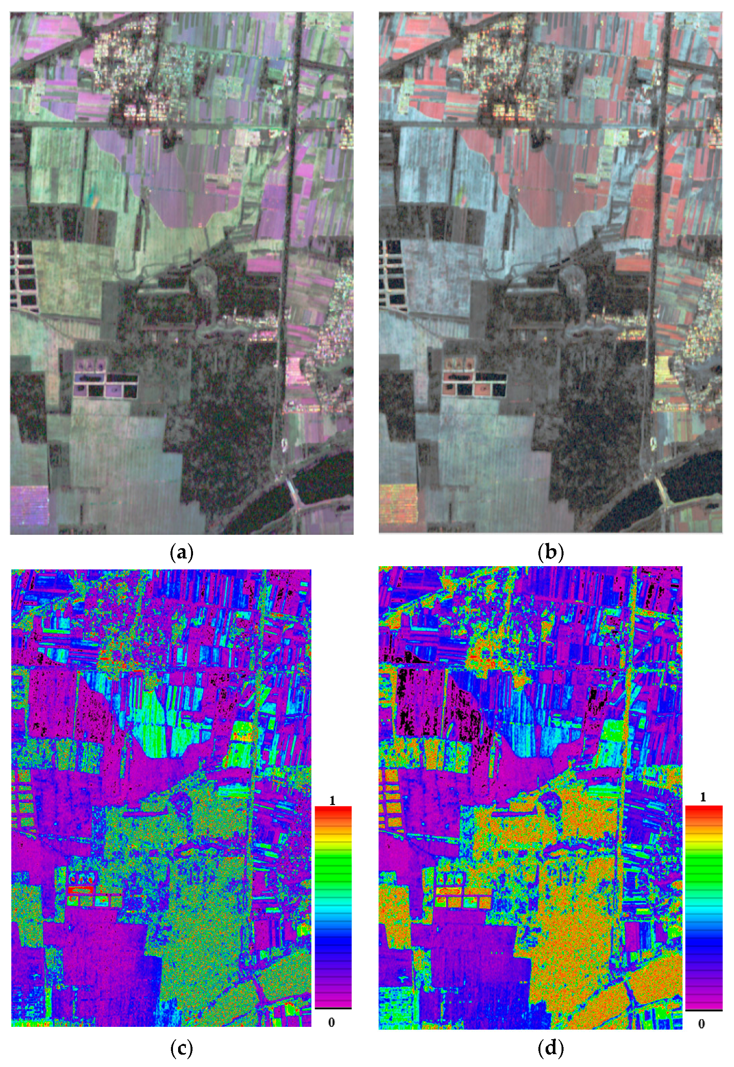
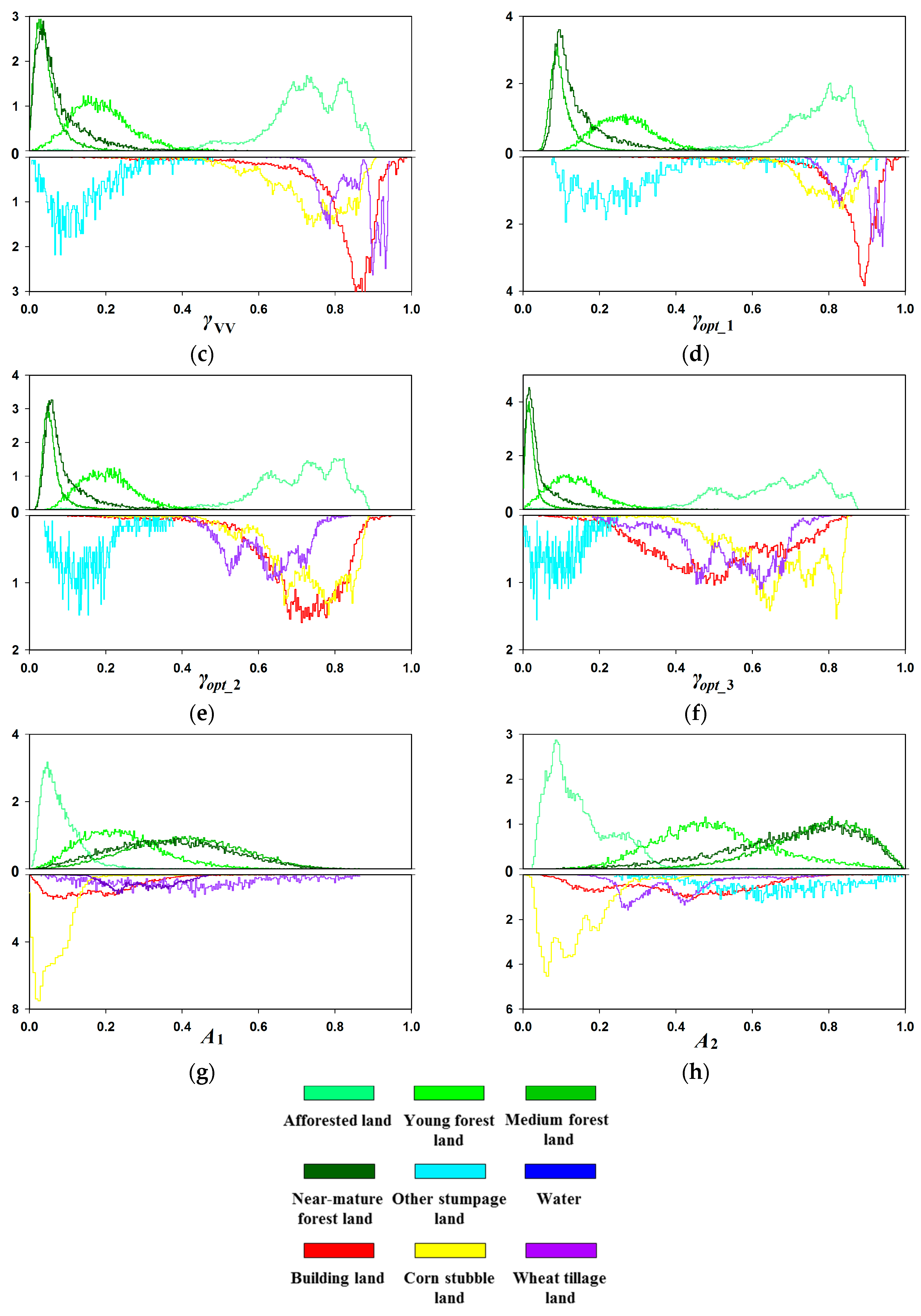
4.1.3. Coherence Features
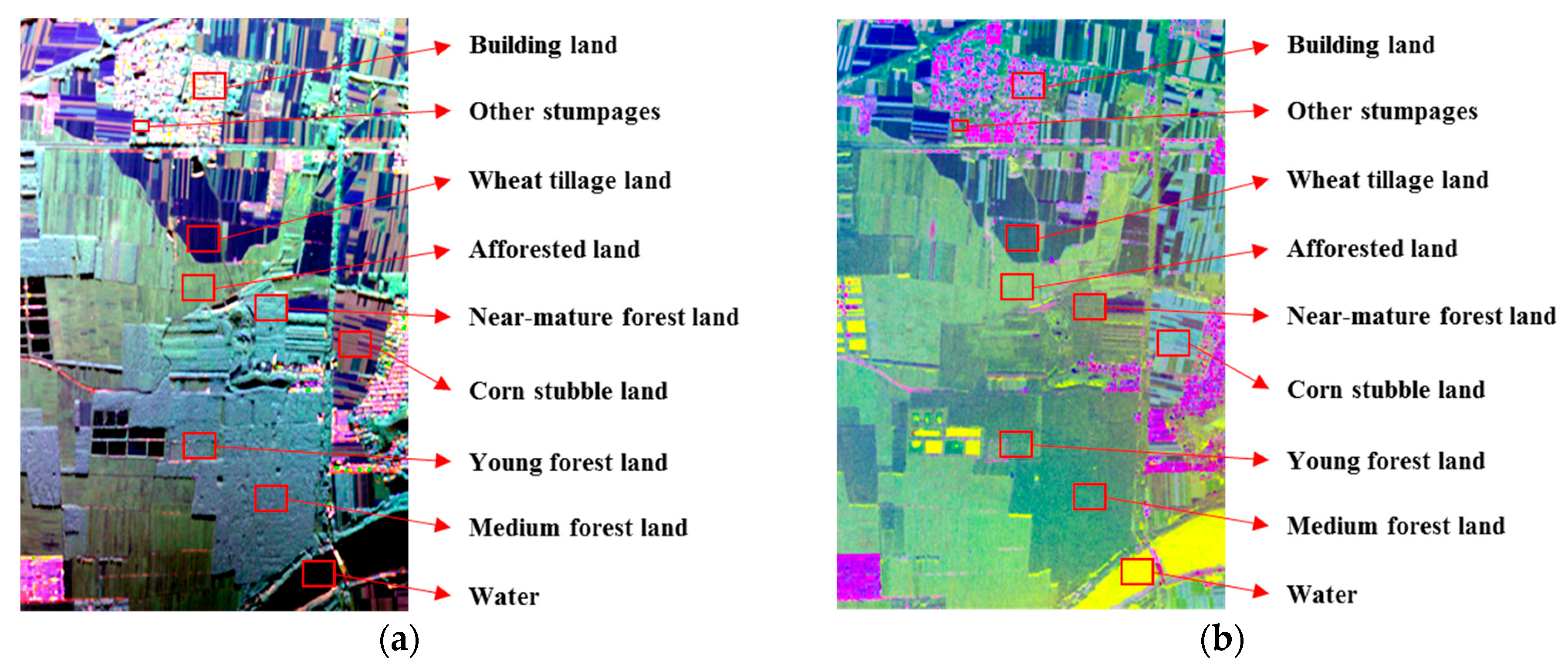
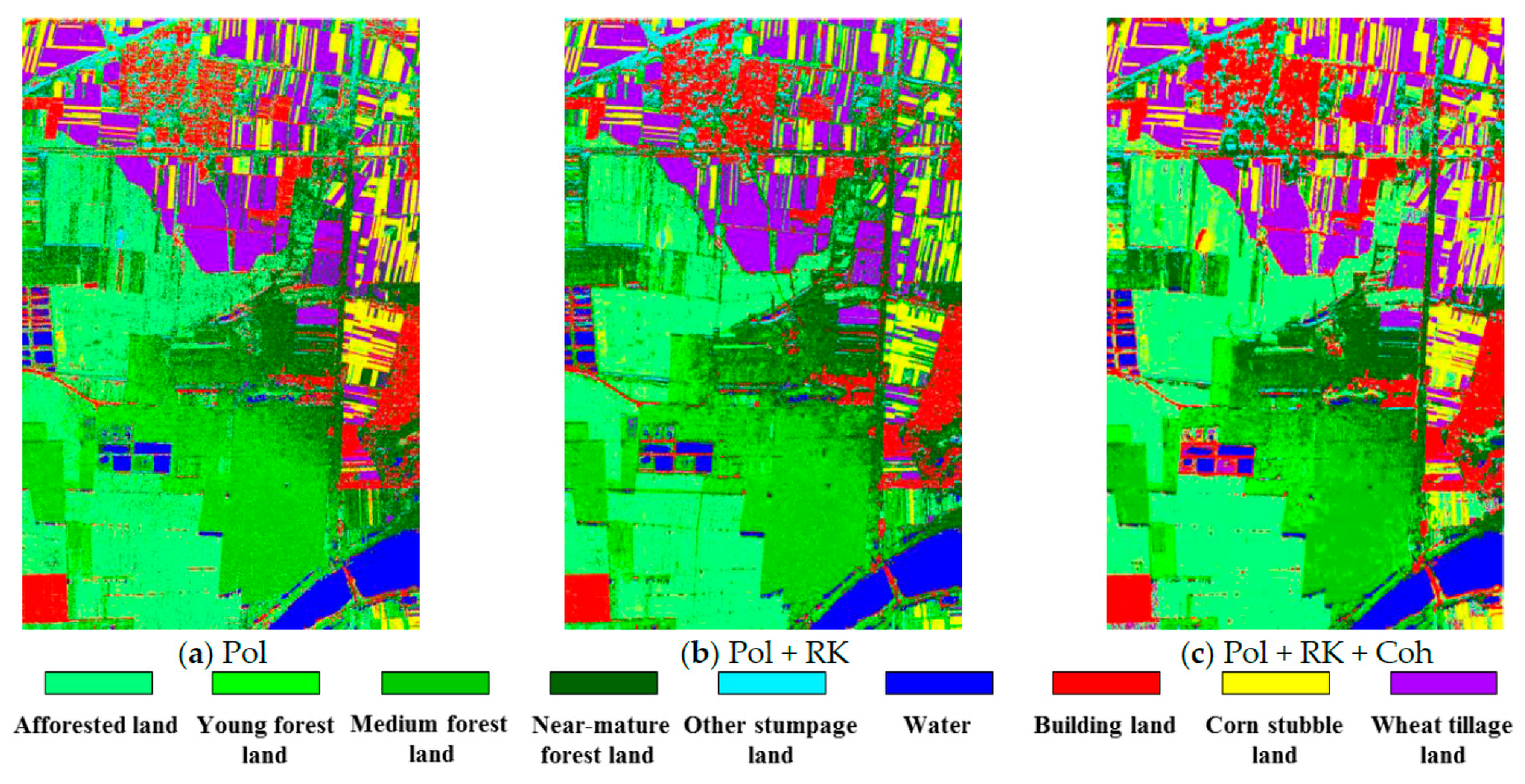
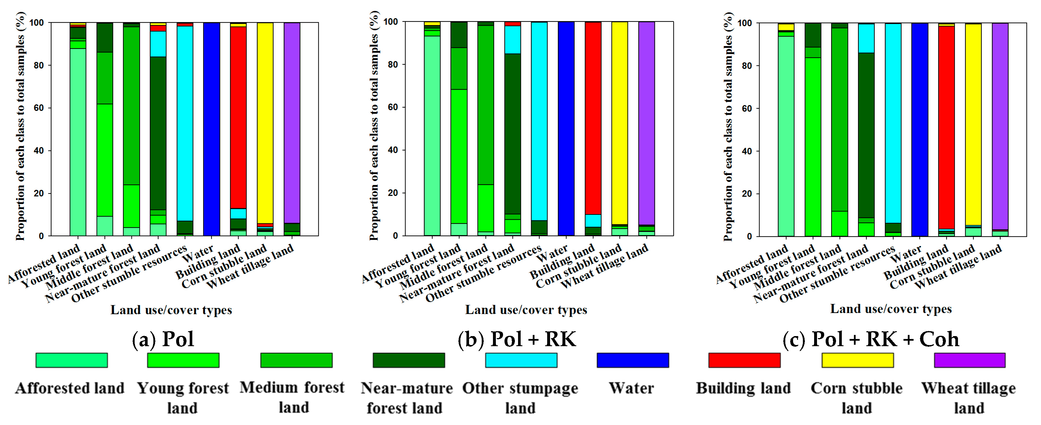
4.2. Classification Results
5. Discussion
6. Conclusions
Acknowledgments
Author Contributions
Conflicts of Interest
References
- West, P. Tree and Forest Measurement, 2nd ed.; Springer: Berlin/Heidelberg, Germany, 2009. [Google Scholar]
- Lucas, R.M.; Clewley, D.; Accad, A. Mapping forest growth and degradation stage in the brigalow belt bioregion of australia through integration of alos palsar and landsat-derived foliage projective cover data. Remote Sens. Environ. 2014, 155, 42–57. [Google Scholar] [CrossRef] [Green Version]
- Galvao, L.S.; Ponzoni, F.J.; Liesenberg, V.; Santos, J.R.D. Possibilities of discriminating tropical secondary succession in Amazonia using hyperspectral and multiangular CHRIS/PROBA data. Int. J. Appl. Earth Obs. Geoinf. 2009, 11, 8–14. [Google Scholar] [CrossRef]
- Wijaya, A.; Reddy Marpu, P.; Gloaguen, R. Discrimination of peatlands in tropical swamp forests using dual-polarimetric SAR and Landsat ETM data. Int. J. Image Data Fusion 2010, 1, 257–270. [Google Scholar] [CrossRef]
- Kuplich, T.M. Classifying regenerating forest stages in Amazonia using remotely sensed images and a neural network. For. Ecol. Manag. 2006, 234, 1–9. [Google Scholar] [CrossRef]
- Xu, L.Y.; Li, S.Q.; Deng, Y.K. Improved Three-stage Algorithm of Forest Height Retrieval with PolInSAR. J. Radars 2014, 3, 28–34. [Google Scholar]
- Xu, F.; Wang, H.P.; Jin, Y.Q. Deep Learning as Applied in SAR Target Recognition and Terrain Classification. J. Radars 2017, 6, 136–148. [Google Scholar]
- Tian, W.; Xu, X.; Bian, X.L. Applications of Environmental Remote Sensing by HJ-1C SAR Imageries. J. Radars 2014, 3, 339–351. [Google Scholar]
- Simard, M.; Saatchi, S.S.; De Grandi, G. The use of decision tree and multiscale texture for classification of JERS-1 SAR data over tropical forest. IEEE Trans. Geosci. Remote Sens. 2000, 38, 2310–2321. [Google Scholar] [CrossRef]
- Ningthoujam, R.K.; Tansey, K.; Balzter, H.; Morrison, K.; Johnson, S.C.M.; Gerard, F.; George, C.; Burbidge, G.; Doody, S.; Veck, N.; et al. Mapping Forest Cover and Forest Cover Change with Airborne S-Band Radar. Remote Sens. 2016, 8, 577. [Google Scholar] [CrossRef]
- Rahman, M.M.; Sumantyo, J.T.S. Erratum to: Mapping Tropical forest cover and deforestation using Synthetic Aperture Radar (SAR) Images. Appl. Geomat. 2010, 2, 197. [Google Scholar] [CrossRef]
- Lehmann, E.A.; Caccetta, P.A.; Zhou, Z.; McNeill, S.J.; Wu, X.; Mitchell, A.L. Joint processing of Landsat and ALOS-PALSAR data for forest mapping and monitoring. IEEE Trans. Geosci. Remote Sens. 2012, 50, 55–67. [Google Scholar] [CrossRef]
- Longepe, N.; Rakwatin, P.; Isoguchi, O.; Shimada, M.; Uryu, Y.; Yulianto, K. Assessment of ALOS PALSAR 50 m orthorectified FBD data for regional land cover classification by Support Vector Machines. IEEE Trans. Geosci. Remote Sens. 2011, 49, 2135–2150. [Google Scholar] [CrossRef]
- Minchella, A.; Del Frate, F.; Capogna, F.; Anselmi, S.; Manes, F. Use of multitemporal SAR data for the monitoring of the vegetation recovery in burned areas. Remote Sens. Environ. 2009, 113, 588–597. [Google Scholar] [CrossRef]
- Lee, J.S.; Papathanassiou, K.P.; Hajnsek, I.; Mette, T. Applying polarimetric SAR interferometric data for forest classification. In Proceedings of the 2005 IEEE International Geoscience and Remote Sensing Symposium (IGARSS 2005), Seoul, Korea, 29 July 2005; Volume 7, pp. 4848–4851. [Google Scholar]
- Hoekman, D.; Quinones, M. Biophysical forest type characterization in the Colombian Amazon by airborne polarimetric SAR. IEEE Trans. Geosci. Remote Sens. 2002, 40, 1288–1300. [Google Scholar] [CrossRef]
- Proisy, C.; Mougin, E.; Dufrene, E.; Dantec, V.L. Monitoring seasonal changes of a mixed temperature forest using ERS SAR observations. IEEE Trans. Geosci. Remote Sens. 2000, 38, 540–552. [Google Scholar] [CrossRef]
- Touzi, R.; Landry, R.; Charbonneau, F.J. Forest type discrimination using calibrated C-band polarimetric SAR data. Can. J. Remote Sens. 2004, 30, 543–551. [Google Scholar] [CrossRef]
- Maghsoudi, Y.; Collins, M.J.; Leckie, D.G. Radarsat-2 Polarimetric SAR Data for Boreal Forest Classification Using SVM and a Wrapper Feature Selector. IEEE J. Sel. Top. Appl. Earth Obs. Remote Sens. 2013, 6, 1531–1538. [Google Scholar] [CrossRef]
- Cloude, S.R.; Pottier, E. A review of target decomposition theorems in radar polarimetry. IEEE Trans. Geosci. Remote Sens. 1996, 34, 498–518. [Google Scholar] [CrossRef]
- Freeman, A.; Durden, S.L. A three-component scattering model for polarimetric SAR data. IEEE Trans. Geosci. Remote Sens. 1998, 36, 963–973. [Google Scholar] [CrossRef]
- Chinatsu, Y.; Manabu, W.; Genya, S. Polarimetric Decomposition Analysis of ALOS PALSAR Observation Data before and after a Landslide Event. Remote Sens. 2012, 4, 2314–2328. [Google Scholar]
- Gama, F.F.; Dos Santos, J.R.; Mura, J.C. Eucalyptus biomass and volume estimation using interferometric and polarimetric SAR data. Remote Sens. 2010, 2, 939–956. [Google Scholar] [CrossRef]
- Lee, J.S.; Grunes, M.R.; Ainsworth, T.L.; Du, L.J.; Schuler, D.L.; Cloude, S.R. Unsupervised classification using polarimetric decomposition and the complex Wishart classifier. IEEE Trans. Geosci. Remote Sens. 1999, 37, 2249–2258. [Google Scholar]
- Ferro-Famil, L.; Pottier, E.; Lee, J.S. Unsupervised classification of multifrequency and fully polarimetric SAR images based on the H/A/Alpha-Wishart classifier. IEEE Trans. Geosci. Remote Sens. 2001, 39, 2332–2342. [Google Scholar] [CrossRef]
- Lee, J.S.; Grunes, M.R.; Pottier, E.; Ferro-Famil, L. Unsupervised terrain classification preserving scattering characteristics. IEEE Trans. Geosci. Remote Sens. 2004, 42, 722–731. [Google Scholar]
- Ferro Famil, L.; Pottier, E.; Lee, J.S. Unsupervised classification of natural scenes from polarimetric interferometric SAR data. In Proceedings of the IEEE 2001 International Geoscience and Remote Sensing Symposium (IGARSS 2001), Sydney, Australia, 9–13 July 2001; Volume 6, pp. 2715–2717. [Google Scholar]
- Ferro-Famil, L.; Kugler, F.; Potier, E.; Lee, J.S. Forest mapping and classification at L-Band using Pol-InSAR optimal coherence set statistics. In Proceedings of the European Conference on Synthetic Aperture Radar, Dresden, Germany, 16–18 May 2006; pp. 1–4. [Google Scholar]
- Lu, D.; Batistella, M.; Moran, E. Land-Cover Classification in the Brazilian Amazon with the Integration of Landsat ETM+ and RADARSAT Data. Int. J. Remote Sens. 2007, 28, 5447–5459. [Google Scholar] [CrossRef]
- Laurin, G.V.; Liesenberg, V.; Chen, Q.; Guerriero, L.; Frate, F.D.; Bartolini, A.; Coomes, D.; Wilebore, B.; Lindsell, J.; Valentini, R. Optical and SAR sensor synergies for forest and land cover mapping in a tropical site in west Africa. Int. J. Appl. Earth Obs. Geoinf. 2013, 21, 7–16. [Google Scholar] [CrossRef]
- Liu, G.; Li, L.; Gong, H.; Jin, Q.W.; Li, X.W.; Song, R.; Chen, Y.; Chen, Y.; He, C.X.; Huang, Y.Q.; et al. Multisource Remote Sensing Imagery Fusion Scheme Based on Bidimensional Empirical Mode Decomposition (BEMD) and Its Application to the Extraction of Bamboo Forest. Remote Sens. 2017, 9, 19. [Google Scholar] [CrossRef]
- Li, G.; Lu, D.; Moran, E.; Dutra, L.; Batistella, M. A Comparative analysis of ALOS PALSAR L-band and RADARSAT-2 C-band data for land-cover classification in a tropical moist region. ISPRS J. Photogramm. Remote Sens. 2012, 70, 26–38. [Google Scholar] [CrossRef]
- Robinson, C.; Saatchi, S.S.; Neumann, M.; Gillespie, T. Impacts of spatial variability on aboveground biomass estimation from L-Band radar in a temperate forest. Remote Sens. 2013, 5, 1001–1023. [Google Scholar] [CrossRef]
- Vapnik, V. Estimation of Dependences Based on Empirical Data; Springer: New York, NY, USA, 2006. [Google Scholar]
- Lin, H.T.; Lin, C.J. A study on sigmoid kernels for SVM and the training of non-PSD kernels by SMO-type methods. Neural Comput. 2003, 27, 15–23. [Google Scholar]
- Merchant, M.A.; Adams, J.R.; Berg, A.A.; Baltzer, J.L.; Quinton, W.L.; Chasmer, L.E. Contributions of c-band SAR data and polarimetric decompositions to subarctic boreal peatland mapping. IEEE J. Sel. Top. Appl. Earth Obs. Remote Sens. 2017, 10, 1467–1482. [Google Scholar] [CrossRef]
- Doulgeris, A. Non-Gaussian Statistical Analysis of Polarimetric Synthetic Aperture Radar Images. Ph.D. Thesis, University of Tromsø (UIT), Tromsø, Norway, 2011. [Google Scholar]
- Papathanassiou, K.P.; Cloude, S.R. Single-baseline polarimetric SAR interferometry. IEEE Trans. Geosci. Remote Sens. 2001, 39, 2352–2363. [Google Scholar] [CrossRef]
- Tison, C.; Pourthié, N.; Souyris, J.C. Target recognition in SAR images with support vector machine (SVM). In Proceedings of the 2007 IEEE International Geoscience and Remote Sensing Symposium (IGARSS 2007), Barcelona, Spain, 23–28 July 2007; pp. 456–459. [Google Scholar]
- Mercier, G.; Girard-Ardhuin, F. Unsupervised oil slick detection by SAR imagery using kernel expansion. In Proceedings of the 2005 IEEE International Geoscience and Remote Sensing Symposium (IGARSS 2005), Seoul, Korea, 29 July 2005; Volume 1, pp. 494–497. [Google Scholar]
- Attarchi, S.; Gloaguen, R. Classifying Complex Mountainous Forests with L-Band SAR and Landsat Data Integration: A Comparison among Different Machine Learning Methods in the Hyrcanian Forest. Remote Sens. 2014, 6, 3624–3647. [Google Scholar] [CrossRef]
- Burges, C.J. A tutorial on support vector machines for pattern recognition. In Data Mining Knowledge Discovery; Fayyad, U., Ed.; Kluwer: Norwell, MA, USA, 1998. [Google Scholar]
- Auer, S.; Gisinger, C.; Tao, J. Characterization of facade regularities in high-resolution SAR images. IEEE Trans. Geosci. Remote Sens. 2015, 53, 2727–2737. [Google Scholar] [CrossRef]
- Gaveau, D.L.A.; Balzter, H.; Plummer, S. Forest woody biomass classification with satellite-based radar coherence over 900,000 km2, in Central Siberia. For. Ecol. Manag. 2003, 174, 65–75. [Google Scholar] [CrossRef]
- Askne, J.I.H.; Santoro, M. Multitemporal repeat pass SAR interferometry of boreal forests. IEEE Trans. Geosci. Remote Sens. 2005, 43, 1219–1228. [Google Scholar] [CrossRef]
- Cartus, O.; Santoro, M.; Schmullius, C. Creation of large area forest biomass maps for Northeast China using ERS-1/2 tandem coherence. In Proceedings of the Dragon 1 Programme Final Results 2004–2007, Beijing, China, 21–25 April 2008; Volume 1, pp. 2004–2007. [Google Scholar]
- Rosen, P.A.; Hensley, S.; Joughin, I.R.; Li, F.K.; Madsen, S.N.; Rodriguez, E.; Goldstein, R.M. Synthetic aperture radar interferometry. Proc. IEEE 2000, 88, 333–382. [Google Scholar] [CrossRef]
- Bamler, R.; Hartl, P. Synthetic aperture radar interferometry. Inverse Probl. 1998, 14, R1–R54. [Google Scholar] [CrossRef]
- Treuhaft, R.N.; Madsen, S.N.; Moghaddam, M.; van Zyl, J.J. Vegetation characteristics and underlying topography from interferometric radar. Radio Sci. 1996, 31, 1449–1485. [Google Scholar] [CrossRef]
- Askne, J.I.H.; Dammert, P.B.G.; Ulander, L.M.H.; Smith, G. C-band repeat-pass interferometric SAR observations of the forest. IEEE Trans. Geosci. Remote Sens. 1997, 35, 25–35. [Google Scholar] [CrossRef]


| Type | Description |
|---|---|
| Afforested land | Tree height is about 2 m and canopy is open. Ground surface is covered with withered grass. |
| Young forest land | Tree height is about 4 m and canopy is relatively open. Ground surface is covered with litter falls or shrub. |
| Medium forest land | Tree height is about 7 m and canopy is relatively closed. Ground surface is covered with litter falls. |
| Near-mature forest land | Tree height is about 9 m and canopy is closed. Ground surface is covered with litter falls. |
| Other stumpages | Scattered trees, four-side trees, a few characteristics of them are similar to those of near-mature forest. |
| Water | Open surface water bodies such as rivers and lakes. |
| Building land | Some are mixed with trees. |
| Wheat tillage land | Wheat has been harvested and surface soil has been turned over. |
| Corn stubble land | Corn has been harvested and surface is covered with straw. |
| ID | Classification Features | Descriptions | References | |
|---|---|---|---|---|
| 1 | Polarization features | Ps, Pd, Pv | Freeman–Durden Decomposition parameters | [19] |
| H, A, α | Cloud–Pottier Decomposition parameters | [20] | ||
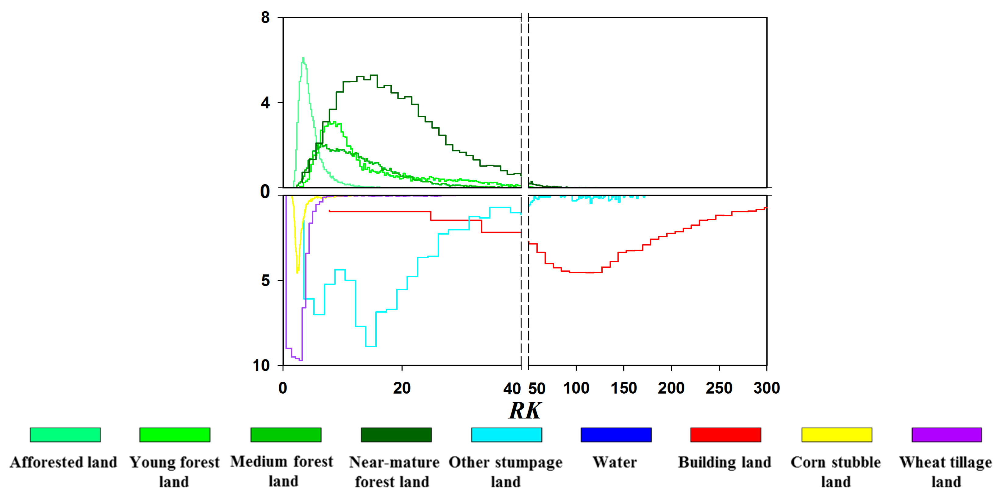
| 2 | Texture features | RK | Relative Kurtosis texture | [36] |
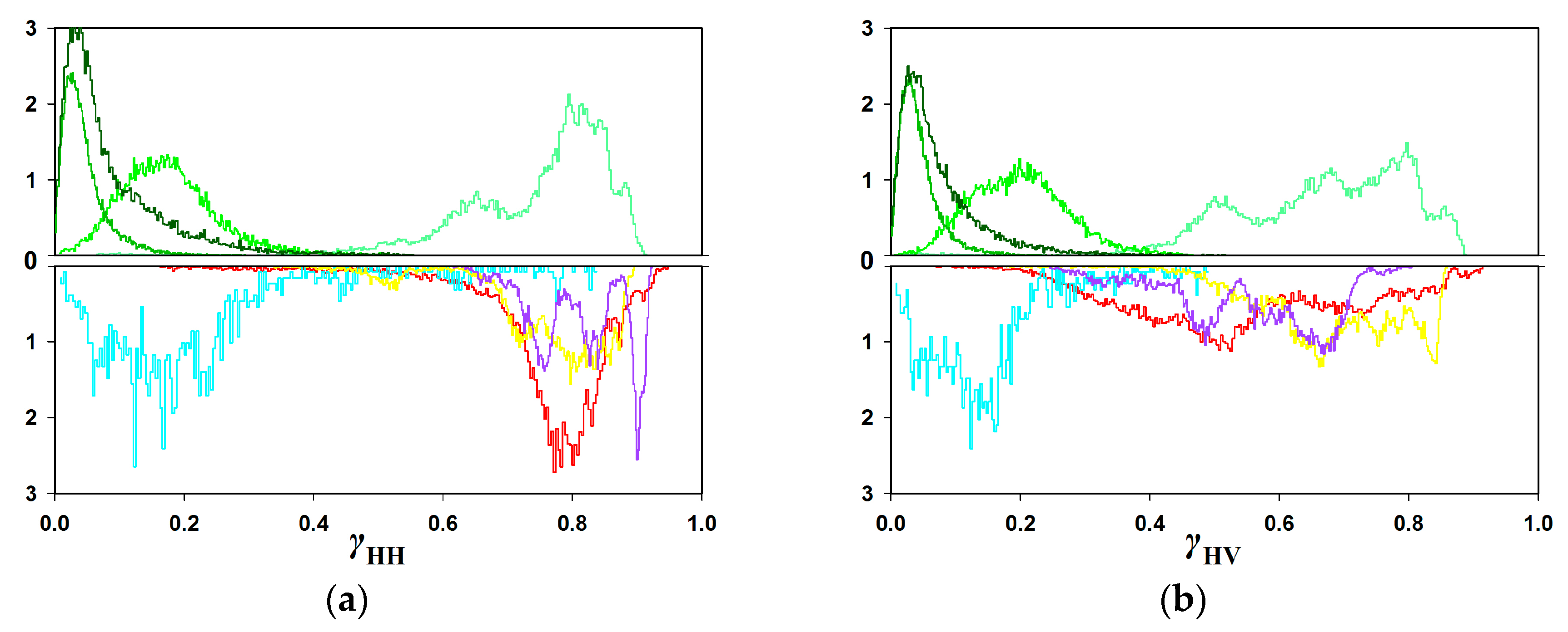
| 3 | Coherence features | γHH, γHV, γVV | Polarimetric interferometric coherence | [26] |
| γopt_1, γopt_2, γopt_3 | Optimal coherence | |||
| A1, A2 | Optimal coherent spectrum | |||
| Type | Number of AOIs | Number of Pixels |
|---|---|---|
| Afforested land | 40 | 6034 |
| Young forest land | 40 | 4353 |
| Medium forest land | 40 | 11,146 |
| Near-mature forest land | 40 | 4640 |
| Other stumpages | 40 | 2421 |
| Water | 20 | 4235 |
| Building land | 40 | 5699 |
| Wheat tillage land | 40 | 5465 |
| Corn stubble land | 40 | 6465 |
| Classification Image | PA (%) | ||||||||||
|---|---|---|---|---|---|---|---|---|---|---|---|
| Afforested Land | Young Forest Land | Medium Forest Land | Near-Mature Forest Land | Other Stumpages | Water | Building Land | Wheat Tillage Land | Corn Stubble Land | |||
| Reference data | Afforested land | 2697 | 110 | 37 | 153 | 12 | 0 | 25 | 36 | 0 | 87.9 |
| Young forest land | 84 | 479 | 221 | 122 | 0 | 0 | 3 | 0 | 0 | 52.7 | |
| Medium forest land | 101 | 508 | 1878 | 37 | 0 | 0 | 4 | 4 | 4 | 74.1 | |
| Near-mature forest land | 65 | 47 | 30 | 831 | 138 | 0 | 32 | 15 | 1 | 71.7 | |
| Other stumpages | 0 | 1 | 0 | 4 | 70 | 1 | 1 | 0 | 0 | 91.0 | |
| Water | 0 | 0 | 0 | 1 | 0 | 594 | 0 | 0 | 0 | 99.8 | |
| Building land | 65 | 12 | 10 | 123 | 124 | 3 | 2202 | 37 | 13 | 85.1 | |
| Wheat tillage land | 23 | 5 | 1 | 9 | 8 | 0 | 18 | 1044 | 1 | 94.1 | |
| Corn stubble land | 3 | 1 | 18 | 39 | 0 | 0 | 3 | 0 | 1000 | 94.0 | |
| UA (%) | 88.8 | 41.2 | 85.6 | 63.0 | 19.8 | 99.3 | 96.2 | 91.9 | 98.1 | ||
| Classification Image | PA (%) | ||||||||||
|---|---|---|---|---|---|---|---|---|---|---|---|
| Afforested Land | Young Forest Land | Medium Forest Land | Near-Mature Forest Land | Other Stumpages | Water | Building Land | Wheat Tillage Land | Corn Stubble Land | |||
| Reference data | Afforested land | 2864 | 75 | 39 | 32 | 1 | 0 | 2 | 56 | 1 | 93.3 |
| Young forest land | 52 | 569 | 177 | 109 | 0 | 0 | 2 | 0 | 0 | 62.6 | |
| Medium forest land | 45 | 560 | 1885 | 41 | 0 | 0 | 2 | 3 | 0 | 74.3 | |
| Near-mature forest land | 14 | 74 | 30 | 867 | 151 | 0 | 23 | 0 | 0 | 74.8 | |
| Other stumpages | 0 | 0 | 1 | 5 | 71 | 0 | 0 | 0 | 0 | 92.2 | |
| Water | 0 | 0 | 0 | 0 | 0 | 595 | 0 | 0 | 0 | 100.0 | |
| Building land | 5 | 13 | 2 | 83 | 152 | 1 | 2326 | 4 | 3 | 89.8 | |
| Wheat tillage land | 37 | 13 | 5 | 3 | 1 | 0 | 0 | 1049 | 1 | 94.6 | |
| Corn stubble land | 21 | 2 | 23 | 6 | 0 | 0 | 2 | 0 | 1010 | 94.9 | |
| UA (%) | 94.3 | 43.6 | 87.2 | 75.7 | 18.9 | 99.8 | 98.7 | 94.3 | 99.5 | ||
| Classification image | PA (%) | ||||||||||
|---|---|---|---|---|---|---|---|---|---|---|---|
| Afforested Land | Young Forest Land | Medium Forest Land | Near-Mature Forest Land | Other Stumpages | Water | Building Land | Wheat Tillage Land | Corn Stubble Land | |||
| Reference data | Afforested land | 2879 | 66 | 2 | 15 | 1 | 0 | 1 | 95 | 11 | 93.8 |
| Young forest land | 0 | 762 | 45 | 102 | 0 | 0 | 0 | 0 | 0 | 83.8 | |
| Medium forest land | 0 | 299 | 2178 | 59 | 0 | 0 | 0 | 0 | 0 | 85.9 | |
| Near-mature forest land | 1 | 74 | 27 | 895 | 158 | 0 | 3 | 1 | 0 | 77.2 | |
| Other stumpages | 0 | 2 | 0 | 3 | 72 | 0 | 0 | 0 | 0 | 93.5 | |
| Water | 0 | 0 | 0 | 0 | 0 | 595 | 0 | 0 | 0 | 100.0 | |
| Building land | 33 | 0 | 0 | 30 | 29 | 0 | 2459 | 28 | 10 | 95.0 | |
| Wheat tillage land | 44 | 4 | 0 | 1 | 8 | 0 | 1 | 1047 | 4 | 94.4 | |
| Corn stubble land | 25 | 0 | 0 | 0 | 0 | 0 | 7 | 2 | 1030 | 96.8 | |
| UA (%) | 96.5 | 63.1 | 96.7 | 81.0 | 26.9 | 100.0 | 99.5 | 89.3 | 97.6 | ||
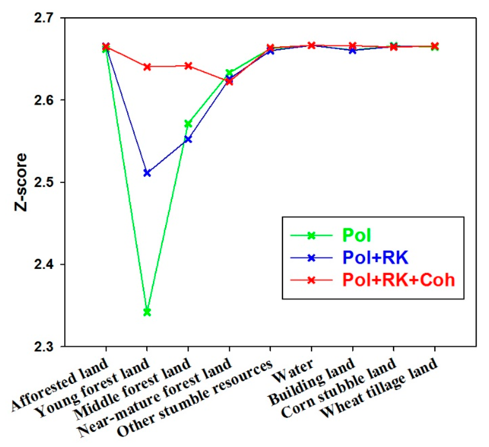
| Pol | Pol + RK | Pol + RK + Coh | |
|---|---|---|---|
| Afforested land | 2.6621 | 2.6656 | 2.6650 |
| Young forest land | 2.3419 | 2.5111 | 2.6407 |
| Medium forest land | 2.5717 | 2.5525 | 2.6417 |
| Near-mature forest land | 2.6332 | 2.6258 | 2.6224 |
| Other stumpages | 2.6626 | 2.6602 | 2.6638 |
| Water | 2.6667 | 2.6667 | 2.6667 |
| Building land | 2.6609 | 2.6605 | 2.6663 |
| Wheat tillage land | 2.6660 | 2.6651 | 2.6645 |
| Corn stubble land | 2.6646 | 2.6657 | 2.6659 |
© 2017 by the authors. Licensee MDPI, Basel, Switzerland. This article is an open access article distributed under the terms and conditions of the Creative Commons Attribution (CC BY) license (http://creativecommons.org/licenses/by/4.0/).
Share and Cite
Feng, Q.; Zhou, L.; Chen, E.; Liang, X.; Zhao, L.; Zhou, Y. The Performance of Airborne C-Band PolInSAR Data on Forest Growth Stage Types Classification. Remote Sens. 2017, 9, 955. https://doi.org/10.3390/rs9090955
Feng Q, Zhou L, Chen E, Liang X, Zhao L, Zhou Y. The Performance of Airborne C-Band PolInSAR Data on Forest Growth Stage Types Classification. Remote Sensing. 2017; 9(9):955. https://doi.org/10.3390/rs9090955
Chicago/Turabian StyleFeng, Qi, Liangjiang Zhou, Erxue Chen, Xingdong Liang, Lei Zhao, and Yu Zhou. 2017. "The Performance of Airborne C-Band PolInSAR Data on Forest Growth Stage Types Classification" Remote Sensing 9, no. 9: 955. https://doi.org/10.3390/rs9090955