Evaluation of Remote-Sensing-Based Landslide Inventories for Hazard Assessment in Southern Kyrgyzstan

Abstract
:
1. Introduction
2. Study Area and Database
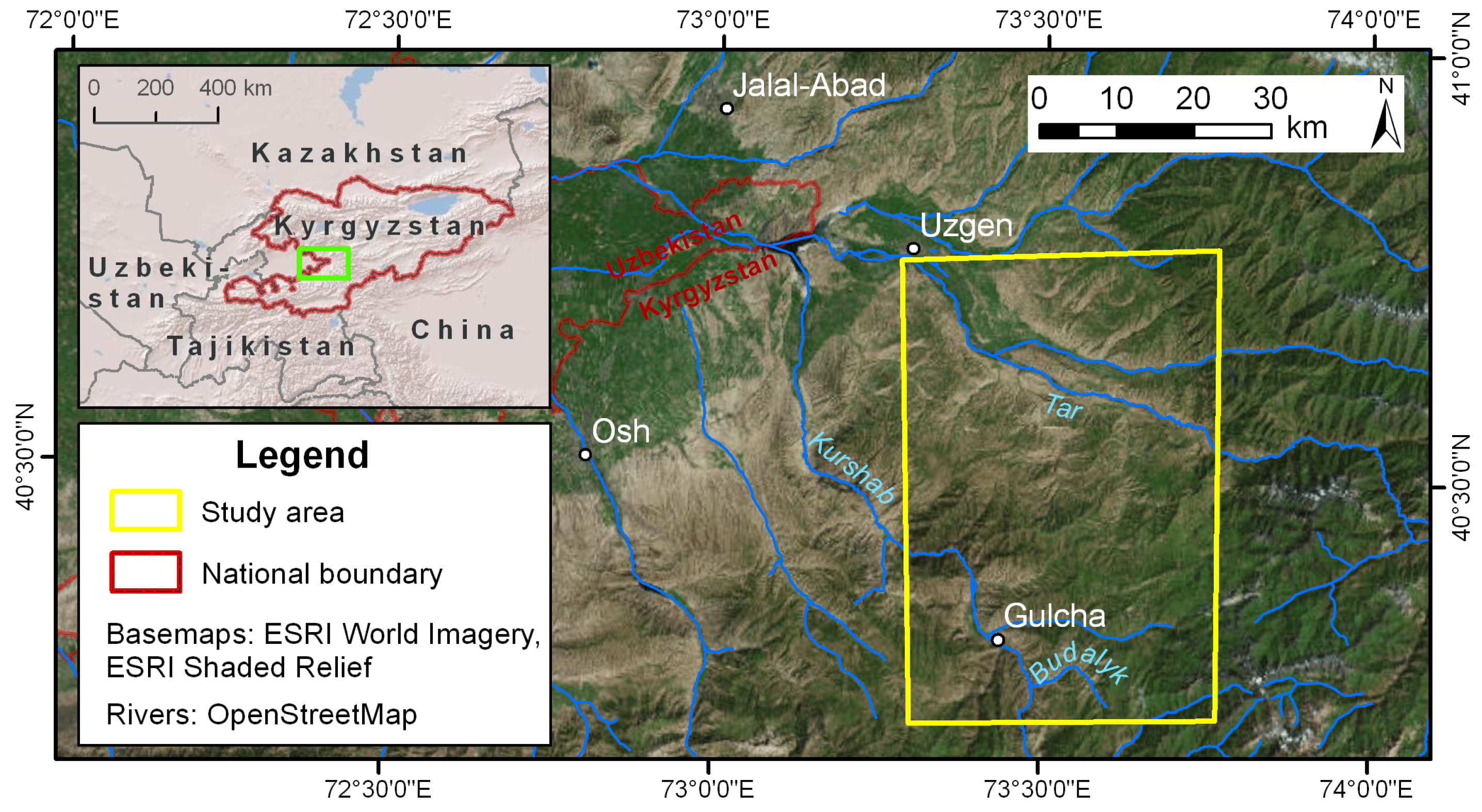
2.1. Study Area
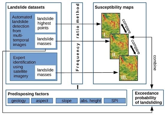
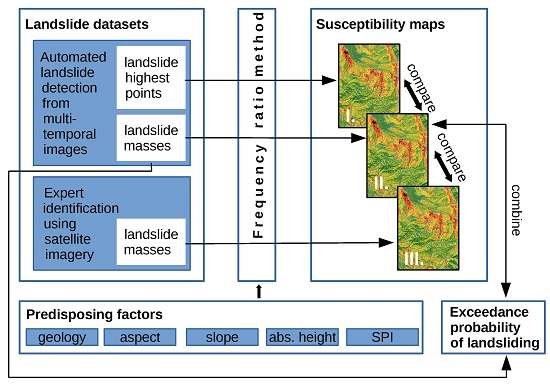
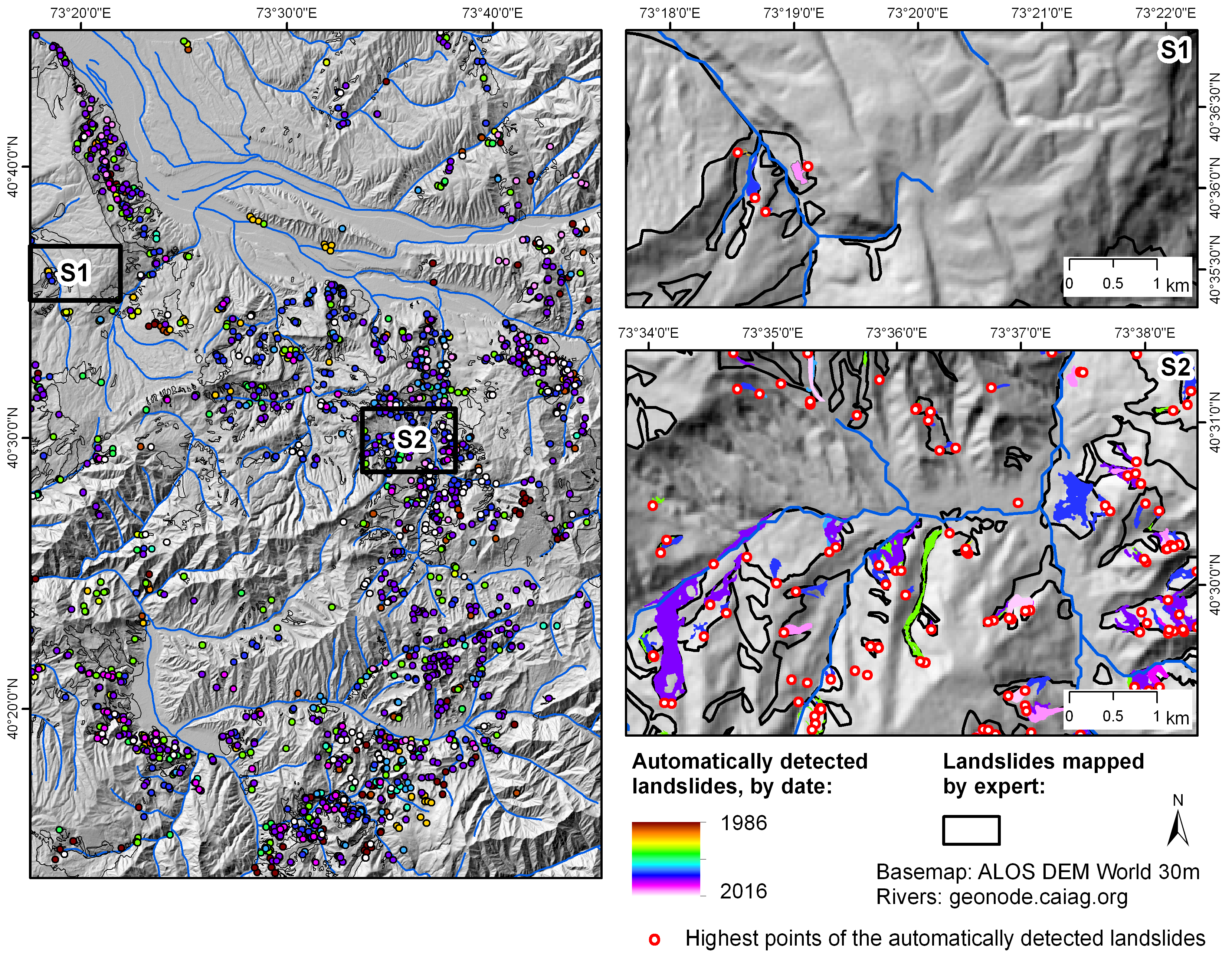
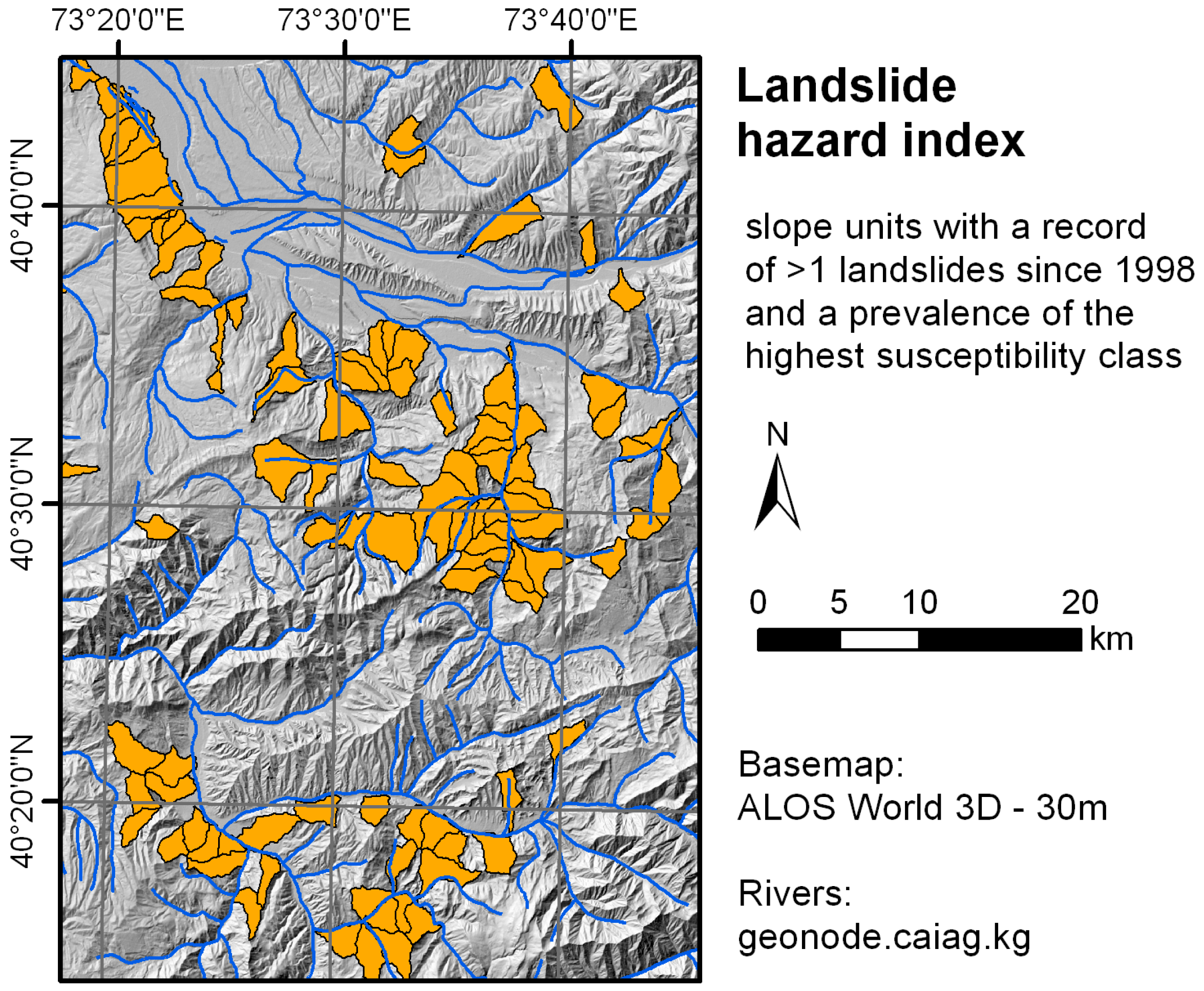
2.2. Landslide Inventory
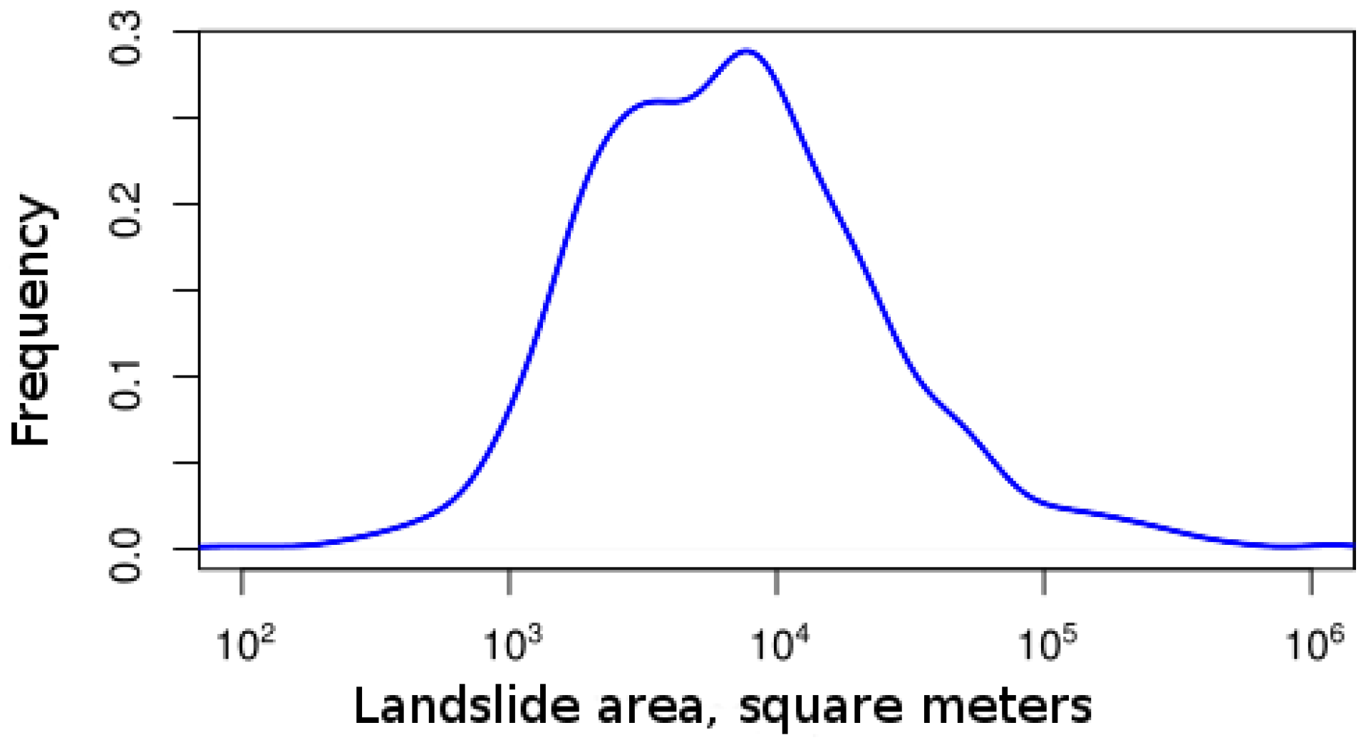
- Automated detection. This dataset was obtained using an automated object-oriented landslide mapping approach that utilizes multi-temporal satellite-based imagery acquired by different optical sensors (Landsat E(TM), SPOT 1-5, ASTER, IRS-1C LISS III, and RapidEye) between 1986 and 2016 [1,2,3,21]. The resulting landslide dataset is composed of 1846 polygons. Each polygon represents the spatial extent of an individual landslide failure. For each landslide polygon, the date of occurrence was determined as the period between two consecutive image acquisitions (before and after the slope failure). The temporal resolution depends on the length of the period between the before and after images. The resolution varies between several years at the beginning and a few weeks at the end of the time span covered by the multi-temporal remote sensing database. The polygons overlap if multiple failures occurred within the same slope over time, which makes it possible to reconstruct the history of landslide reactivations. The resulting dataset is a systematic record of the landslides in the study area that occurred during the past 30 years. This may appear to be a short landslide record, particularly compared to some European countries with very extensive spatial data on landsliding. However, for southern Kyrgyzstan, this dataset is of unprecedented quality and completeness. The length of the period covered by this dataset will increase as new high-resolution satellite images are acquired, but an evaluation of the properties of the dataset and its influence on the susceptibility results can already be performed with the 30-year coverage.
- Expert interpretation. Areas that experienced landsliding in the past and that still exhibit morphological evidence of these past slope failures were mapped visually by an expert. The mapping was based on RapidEye images acquired between 2012 and 2015, a digital elevation model (DEM) and geological information. The resulting dataset represents the cumulative result of landsliding with no information on the failure dates and without the differentiation of the spatial extents of individual activations. Thus, in contrast to the automatically detected dataset, the results of expert interpretation do not contain individual landslide objects but rather a mask that shows whether the given location was affected by landsliding in the past.
2.3. Predisposing Factors
- Basement: Metamorphic and igneous rocks;
- Jurassic (J1–J3): Sandstones, siltstones, and slates;
- Upper Cretaceous—Paleogene (Cr1–Cr2): red sandstones, conglomerates, gravels, gypsolytes, limestones, clays, and siltstones;
- Lower Eocene—Oligocene (Pg1–Pg2): sandstones, gypsolytes, limestones, marls, clays, and siltstones;
- Oligocene—Miocene (Pg3–N1): red sandstones, conglomerates, and clays;
- Pliocene (N2): conglomerates, gravels, and loess-type loams;
- Lower Quaternary (Q1): gray conglomerates and loesses;
- Middle Quaternary (Q2): glacial moraines, loesses, and alluvial sediments;
- Upper Quaternary (Q3–Q4): alluvial sediments, glacial moraines, and loesses.
- Aspect shows the exposition of the slope, classified into eight cardinal and intercardinal directions.
- Slope characterizes the steepness of the slope.
3. Methods
3.1. Frequency Ratio Method
- is the number of landslide pixels in each class i;
- is the total number of pixels that have class i in the study area;
- is the total number of landslide pixels in the study area;
- and is the total number of pixels in the study area.
3.2. Validation of Susceptibility Assessment
- The datasets obtained by automated detection (both the landslide highest points and the landslide masses) are divided into training and validation parts. This is a standard approach for validating the susceptibility results when a single landslide dataset is available [29,30]. We divide the datasets into 50%/50% parts.
- The expert interpretation dataset is used for training the model, and the automated detection dataset (landslide masses) is used for validating the model. The goal is to understand whether the automatically detected dataset, which is based on a relatively short 30-year observation period, is capable of producing results that are comparable to the labor-intensive geomorphological mapping.
- The automated results of 2009–2016 (landslide masses) are used to train the model, and the automatic detection dataset of 1986–2009 is utilized to validate the model. This is an attempt to evaluate the reliability of the susceptibility mapping in a scenario where only RapidEye satellite images are available.
3.3. Temporal Probability of Landsliding
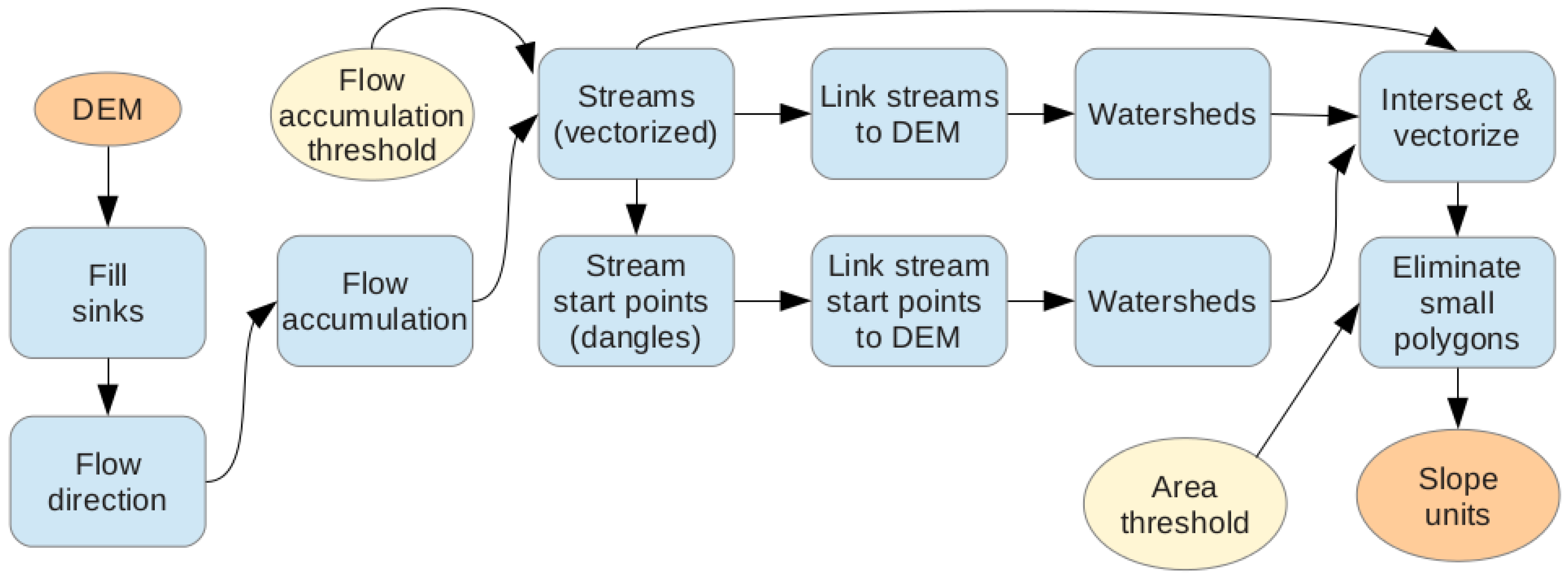
3.4. Mapping Units
4. Results
4.1. Landslide Susceptibility
4.1.1. Model Results
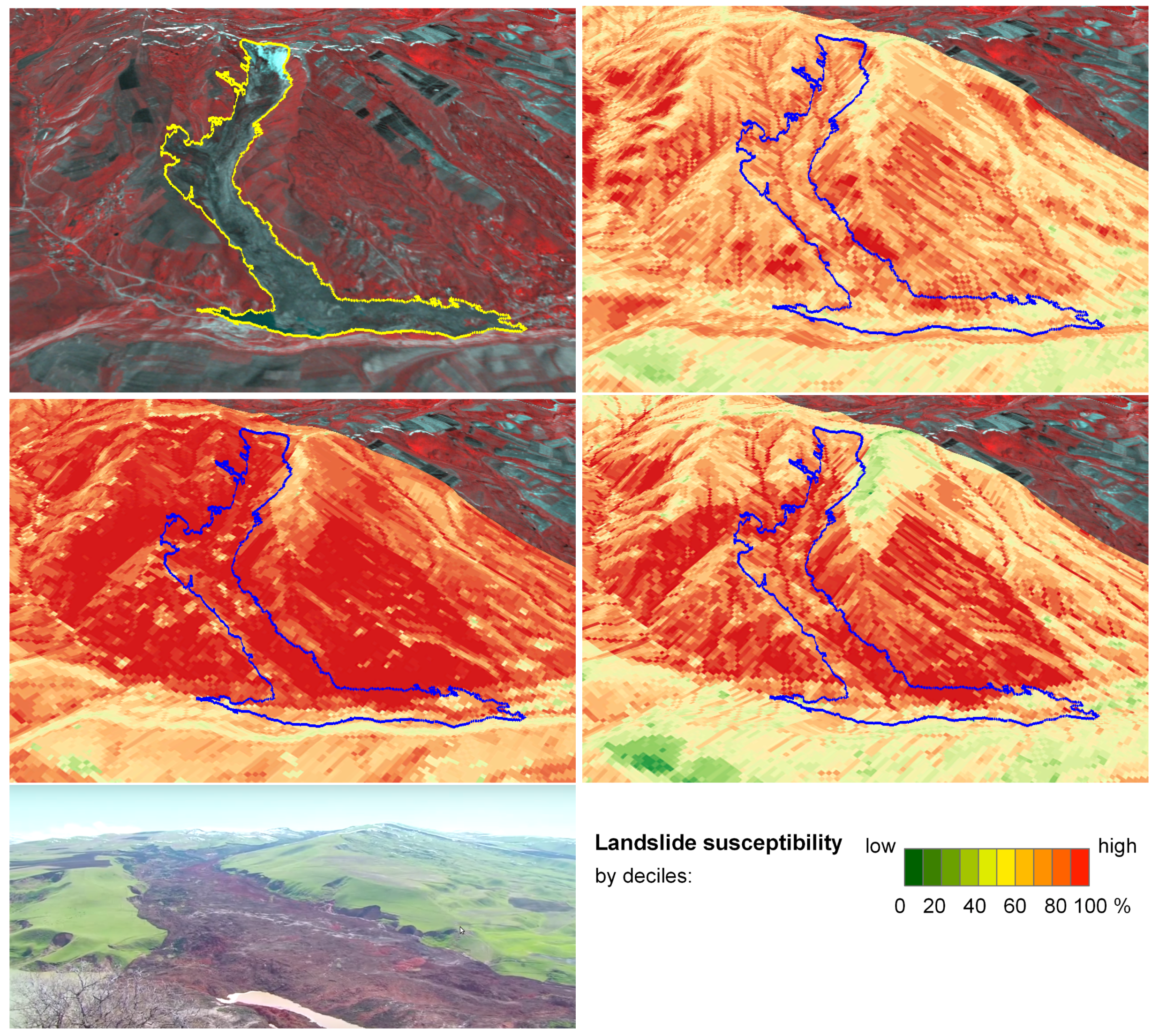
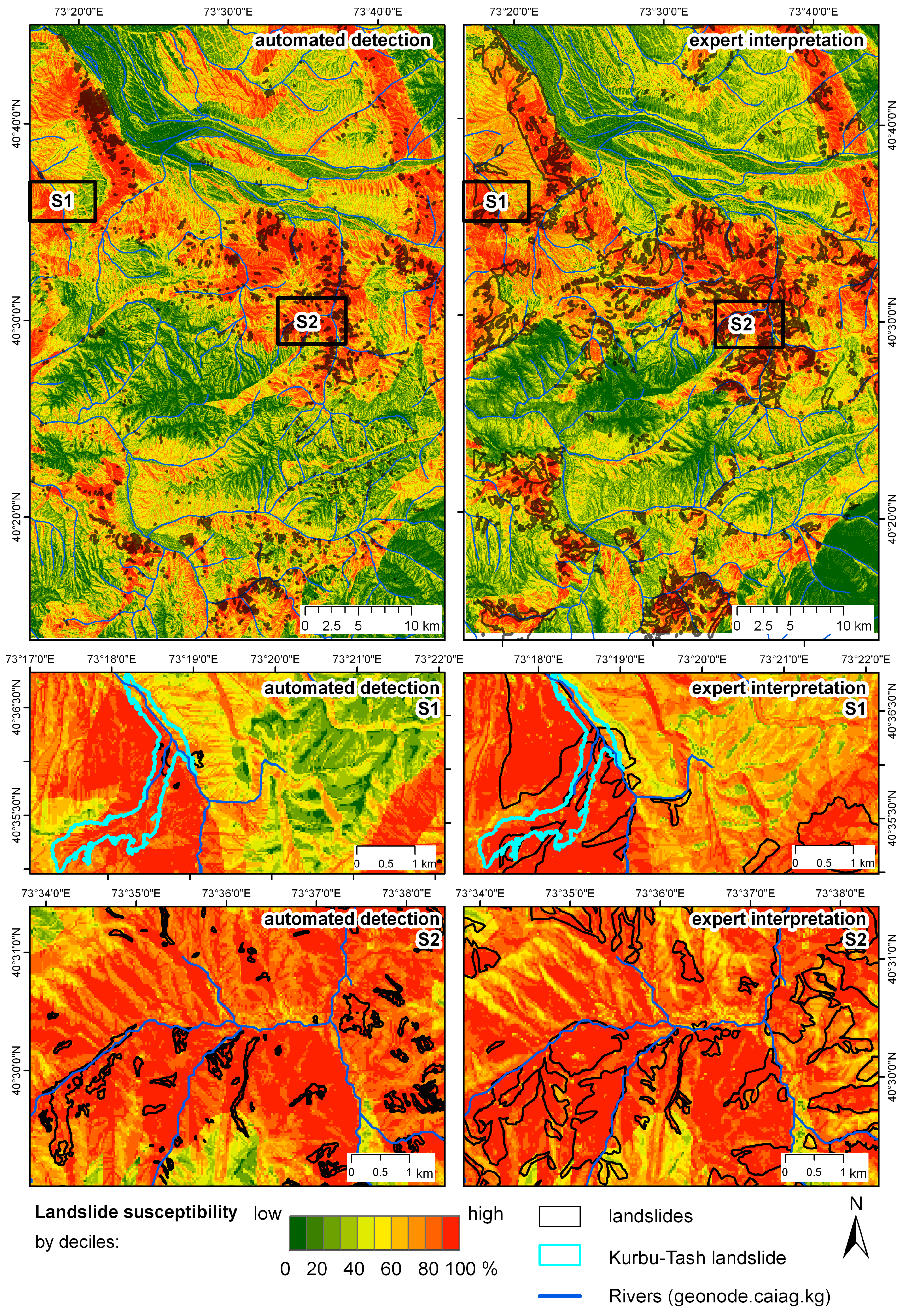
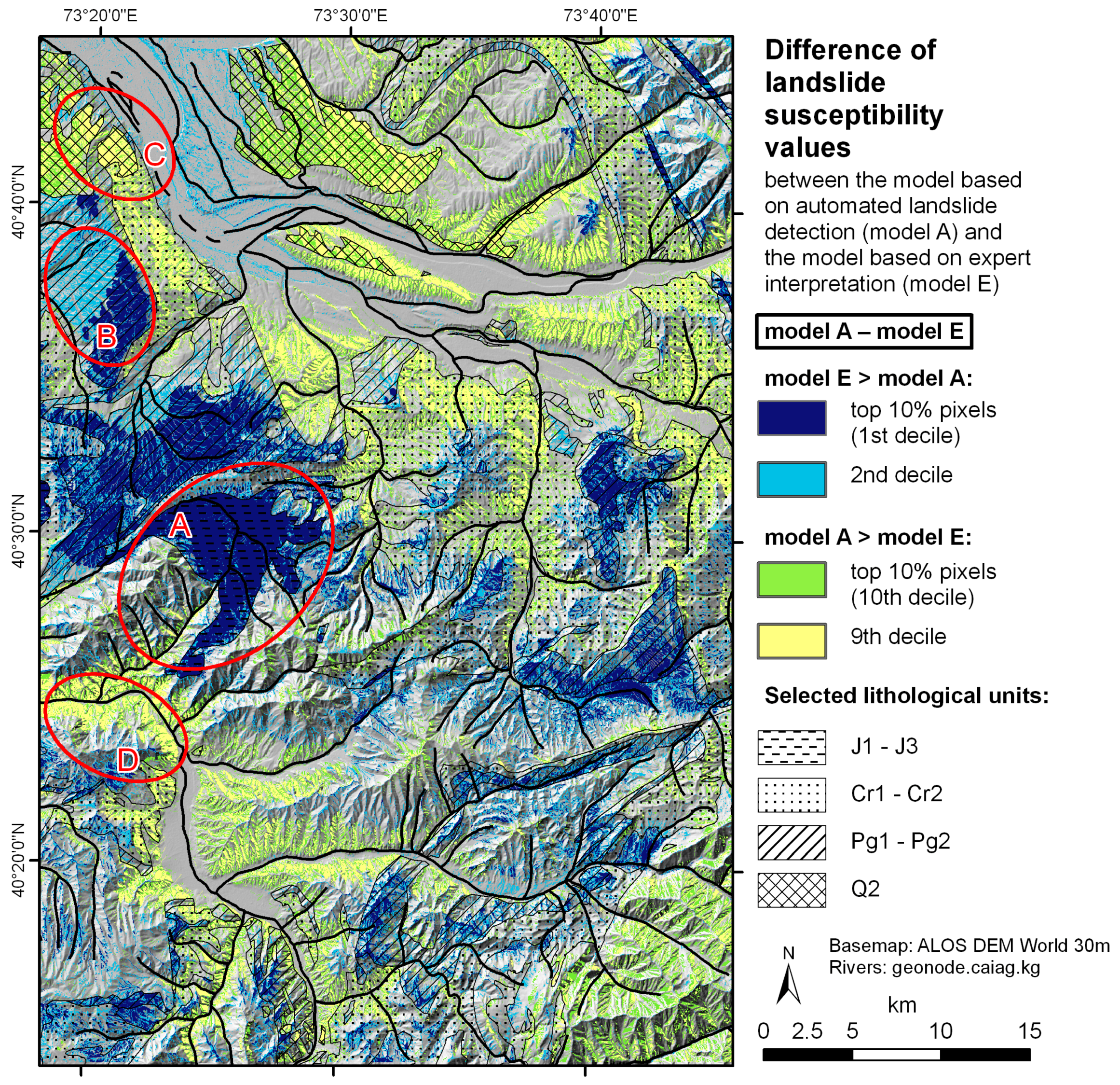
4.1.2. Comparison of Susceptibility Maps: Automated Detection vs. Expert Interpretation
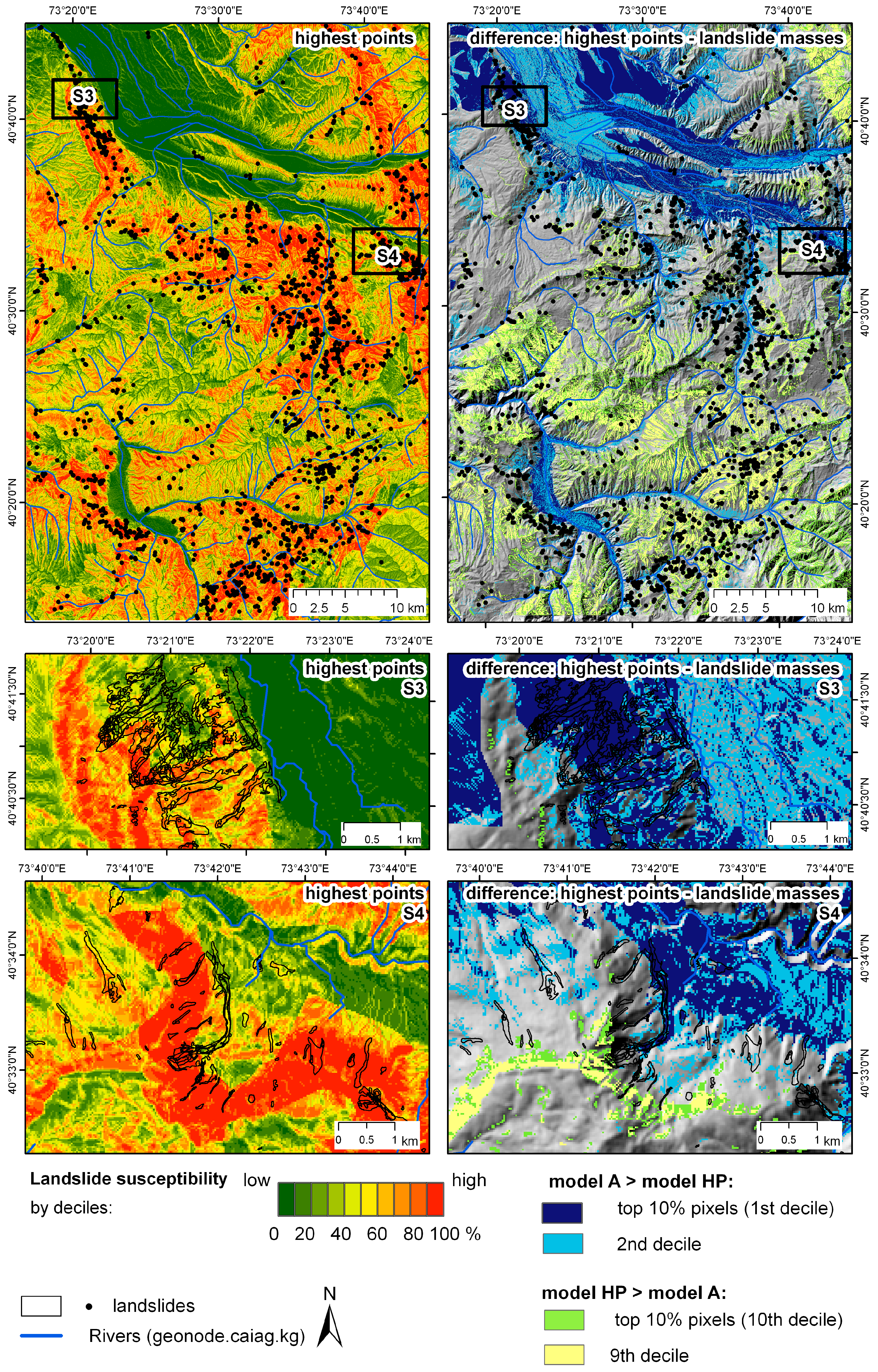
4.1.3. Comparison of Susceptibility Maps: Landslide Masses vs. Highest Points
4.1.4. Validation
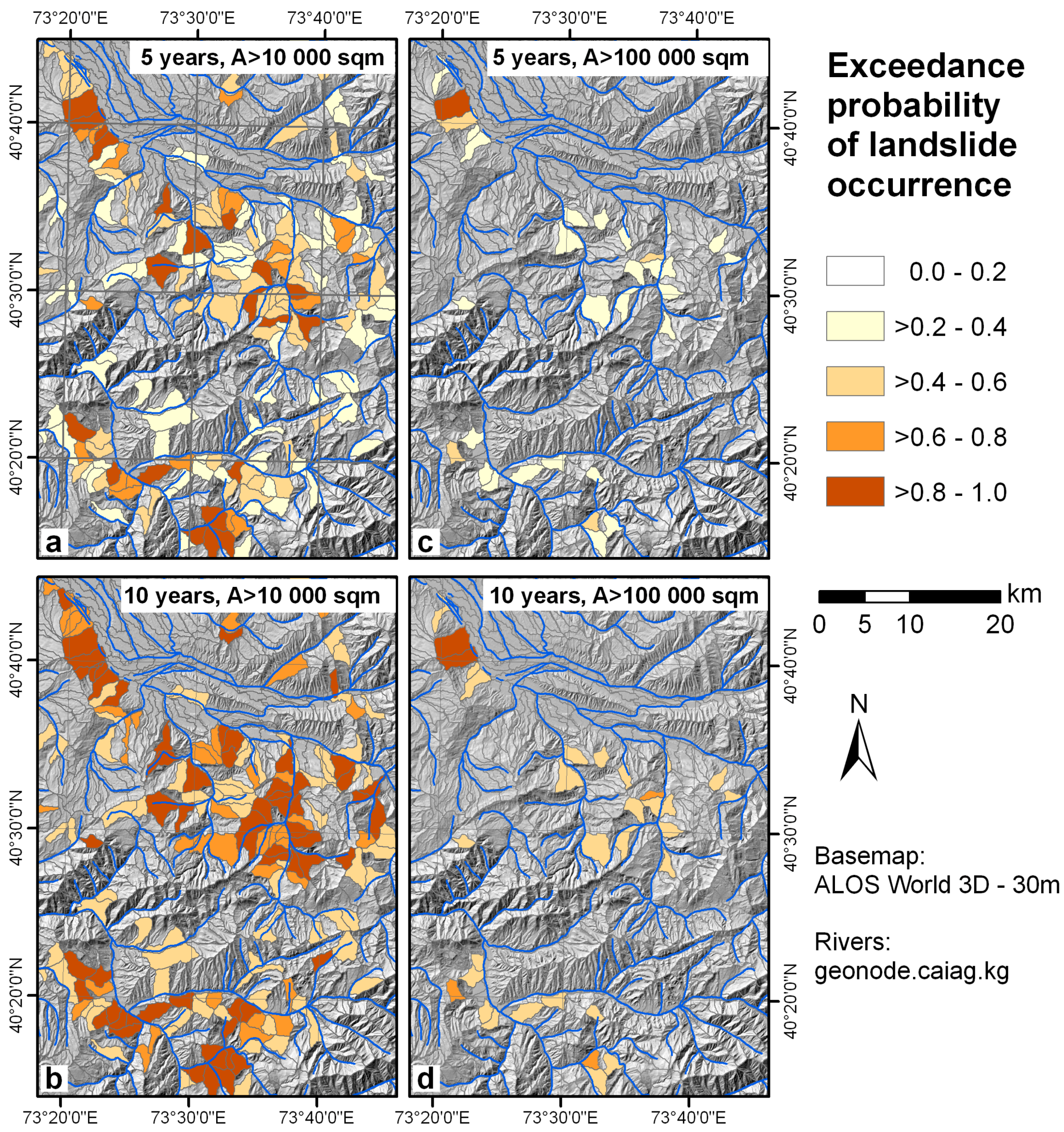
4.2. Temporal Probability of Landsliding
5. Discussion
6. Conclusions
Acknowledgments
Author Contributions
Conflicts of Interest
References
- Behling, R.; Roessner, S.; Segl, K.; Kleinschmit, B.; Kaufmann, H. Robust Automated Image Co-Registration of Optical Multi-Sensor Time Series Data: Database Generation for Multi-Temporal Landslide Detection. Remote Sens. 2014, 6, 2572–2600. [Google Scholar] [CrossRef]
- Behling, R.; Roessner, S.; Golovko, D.; Kleinschmit, B. Derivation of long-term spatiotemporal landslide activity—A multi-sensor time series approach. Remote Sens. Environ. 2016, 186, 88–104. [Google Scholar] [CrossRef]
- Behling, R.; Roessner, S.; Kaufmann, H.; Kleinschmit, B. Automated Spatiotemporal Landslide Mapping over Large Areas Using RapidEye Time Series Data. Remote Sens. 2014, 6, 8026–8055. [Google Scholar] [CrossRef]
- Guzzetti, F.; Reichenbach, P.; Cardinali, M.; Galli, M.; Ardizzone, F. Probabilistic landslide hazard assessment at basin scale. Geomorphology 2005, 72, 272–299. [Google Scholar] [CrossRef]
- Guzzetti, F.; Mondini, A.C.; Cardinali, M.; Fiorucci, F. Landslide inventory maps: New tools for an old problem. Earth Sci. Rev. 2012, 112, 42–66. [Google Scholar] [CrossRef]
- Van Westen, C.J.; Castellanos, E.; Kuriakose, S.L. Spatial data for landslide susceptibility, hazard, and vulnerability assessment: An overview. Eng. Geol. 2008, 102, 112–131. [Google Scholar] [CrossRef]
- Corominas, J.; van Westen, C.; Frattini, P.; Cascini, L.; Malet, J.P.; Fotopoulou, S.; Catani, F.; Van Den Eeckhaut, M.; Mavrouli, O.; Agliardi, F.; et al. Recommendations for the quantitative analysis of landslide risk. Bull. Eng. Geol. Environ. 2014, 73, 209–263. [Google Scholar]
- Fressard, M.; Thiery, Y.; Marquaire, O. Which data for quantitative landslide susceptibility mapping at operational scale? Case study of the Pays d’Auge plateau hillslopes (Normandy, France). Nat. Hazards Earth Syst. Sci. 2014, 14, 569–588. [Google Scholar] [CrossRef] [Green Version]
- Brenning, A. Spatial prediction models for landslide hazards: review, comparison and evaluation. Nat. Hazards Earth Syst. Sci. 2007, 91, 853–862. [Google Scholar] [CrossRef]
- Pourghasemi, H.R.; Moradi, H.R.; Fatemi Aghda, S.M. Landslide susceptibility mapping by binary logistic regression, analytical hierarchy process, and statistical index models and assessment of their performances. Nat. Hazards 2013, 69, 749–779. [Google Scholar] [CrossRef]
- Pradhan, B. A Comparative Study on the Predictive Ability of the Decision Tree, Support Vector Machine and Neuro-fuzzy Models in Landslide Susceptibility Mapping Using GIS. Comput. Geosci. 2013, 51, 350–365. [Google Scholar] [CrossRef] [Green Version]
- Yilmaz, I. Landslide susceptibility mapping using frequency ratio, logistic regression, artificial neural networks and their comparison: A case study from Kat landslides (Tokat—Turkey). Comput. Geosci. 2009, 35, 1125–1138. [Google Scholar] [CrossRef]
- Steger, S.; Brenning, A.; Bell, R.; Glade, T. The propagation of inventory-based positional errors into statistical landslide susceptibility models. Nat. Hazards Earth Syst. Sci. 2016, 16, 2729–2745. [Google Scholar] [CrossRef]
- Pellicani, R.; Spilotro, G. Evaluating the quality of landslide inventory maps: comparison between archive and surveyed inventories for the Daunia region (Apulia, Southern Italy). Bull. Eng. Geol. Environ. 2015, 74, 357–367. [Google Scholar] [CrossRef]
- Galli, M.; Ardizzone, F.; Cardinali, M.; Guzzetti, F.; Reichenbach, P. Comparing landslide inventory maps. Geomorphology 2008, 94, 268–289. [Google Scholar] [CrossRef]
- Golovko, D.; Roessner, S.; Behling, R.; Wetzel, H.U.; Kleinschmit, B. Development of Multi-Temporal Landslide Inventory Information System for Southern Kyrgyzstan Using GIS and Satellite Remote Sensing. PFG Photogramm. Fernerkund. Geoinf. 2015, 2, 157–172. [Google Scholar] [CrossRef]
- Golovko, D.; Roessner, S.; Behling, R.; Kleinschmit, B. Automated derivation and spatio-temporal analysis of landslide properties in southern Kyrgyzstan. Nat. Hazards 2017, 85, 1461–1488. [Google Scholar] [CrossRef]
- Ibatulin, K.V. Monitoring of Landslides in Kyrgyzstan; Ministry of Emergency Situations of the Kyrgyz Republic: Bishkek, Kyrgyzstan, 2011. (In Russian)
- Torgoev, I.A.; Aleshin, Y.G.; Meleshko, A.; Havenith, H.B. Landslide hazard in the Kyrgyz Tien Shan. In Proceedings of the Mountain Risks Conference, Firenze, Italy, 24–26 November 2010. [Google Scholar]
- Danneels, G.; Bordeau, C.; Torgoev, I.; Havenith, H.B. Geophysical investigation and dynamic modelling of unstable slopes: Case-study of Kainama (Kyrgyzstan). Geophys. J. Int. 2008, 175, 17–34. [Google Scholar] [CrossRef]
- Behling, R.; Roessner, S. Spatiotemporal Landslide Mapper for Large Areas Using Optical Satellite Time Series Data. In Advancing Culture of Living with Landslides; Mikos, M., Arbanas, Z., Yin, Y., Sassa, K., Eds.; Springer International Publishing: Cham, Switzerland, 2017. [Google Scholar]
- ALOS DEM World—30m. Available online: http://www.eorc.jaxa.jp/ALOS/en/aw3d30/ (accessed on 30 July 2017).
- Roessner, S.; Wetzel, H.U.; Kaufmann, H.; Sarnagoev, A. Potential of Satellite Remote Sensing and GIS for Landslide Hazard Assessment in Southern Kyrgyzstan (Central Asia). Nat. Hazards 2005, 35, 395–416. [Google Scholar] [CrossRef]
- Jebur, M.N.; Pradhan, B.; Tehrany, M.S. Optimization of landslide conditioning factors using very high-resolution airborne laser scanning (LiDAR) data at catchment scale. Remote Sens. Environ. 2014, 152, 150–165. [Google Scholar] [CrossRef]
- Moore, I.D.; Grayson, R.B.; Ladson, A.R. Digital terrain modelling: A review of hydrogical, geomorphological, and biological applications. Hydrol. Process. 1991, 5, 3–30. [Google Scholar] [CrossRef]
- Lee, S.; Talib, J.A. Probabilistic landslide susceptibility and factor effect analysis. Environ. Geol. 2005, 47, 982–990. [Google Scholar] [CrossRef]
- Intarawichian, N.; Dasananda, S. Frequency ratio model based landslide susceptibility mapping in lower Mae Chaem watershed, Northern Thailand. Environ. Earth Sci. 2011, 64, 2271–2285. [Google Scholar] [CrossRef]
- Begueria, S. Validation and Evaluation of Predictive Models in Hazard Assessment and Risk Management. Nat. Hazards 2006, 37, 315–329. [Google Scholar] [CrossRef] [Green Version]
- Van Den Eeckhaut, M.; Reichenbach, P.; Guzzetti, F.; Rossi, M.; Poesen, J. Combined landslide inventory and susceptibility assessment based on different mapping units: An example from the Flemish Ardennes, Belgium. Nat. Hazards Earth Syst. Sci. 2009, 9, 507–521. [Google Scholar] [CrossRef]
- Chung, C.J.; Fabbri, A.G. Predicting landslides for risk analysis—Spatial models tested by a cross-validation technique. Geomorphology 2008, 3–4, 438–452. [Google Scholar] [CrossRef]
- Remondo, J.; Gonzälez, A.; Díaz de Terán, J.; Cendrero, a.; Fabbri, A.; Chung, C.J.F. EValidation of Landslide Susceptibility Maps; Examples and Applications from a Case Study in Northern Spain. Nat. Hazards 2003, 30, 437–449. [Google Scholar] [CrossRef]
- Corominas, J.; Moya, J. A review of assessing landslide frequency for hazard zoning purposes. Eng. Geol. 2008, 102, 193–213. [Google Scholar] [CrossRef]
- Havenith, H.B.; Torgoev, A.; Schlögel, R.; Braun, A.; Torgoev, I.; Ischuk, A. Tien Shan Geohazards Database: Landslide susceptibility and analysis. Geomorphology 2015, 249, 32–43. [Google Scholar] [CrossRef]
- Malamud, B.D.; Turcotte, D.L.; Guzzetti, F.; Reichenbach, P. Landslide inventories and their statistical properties. Earth Surf. Process. Landf. 2004, 29, 687–711. [Google Scholar] [CrossRef]
- Guzzetti, F.; Carrara, A.; Cardinali, M.; Reichenbach, P. Landslide hazard evaluation: A review of current techniques and their application in a multi-scale study, Central Italy. Geomorphology 1999, 31, 181–216. [Google Scholar] [CrossRef]
- Erener, A.; Düzgün, H.S.B. Landslide susceptibility assessment: what are the effects of mapping unit and mapping method? Environ. Earth Sci. 2012, 66, 859–877. [Google Scholar] [CrossRef]
- QGIS Plugin Landslide Tools. Available online: https://github.com/daryagol/landslidetools (accessed on 5 May 2017).
- Steger, S.; Brenning, A.; Bell, R.; Petschko, H.; Glade, T. Exploring discrepancies between quantitative validation results and the geomorphic plausibility of statistical landslide susceptibility maps. Geomorphology 2017, 262, 8–23. [Google Scholar] [CrossRef]
- Ministry of Emergency Situations of the Kyrgyz Republic. Reasons for the Activization of Landsliding. Available online: http://mes.kg/ru/news/full/9875.html (accessed on 27 May 2017). (In Russian)
- AKIpress. Massive Landslide in Osh Region, Kyrgyzstan May 2017. Available online: https://akipress.com/video:651/ (accessed on 27 May 2017).
- Petley, D. Ayu in Osh, Kyrgyzstan: A Large Landslide Has Killed 24 People, and Another Large Flowslide in Uzgen Region. Available online: http://blogs.agu.org/landslideblog/2017/05/02/ayu-1/ (accessed on 27 May 2017).
- Wang, Q.; Wang, D.; Huang, Y.; Wang, Z.; Zhang, L.; Guo, Q.; Chen, W.; Chen, W.; Sang, M. Landslide Susceptibility Mapping Based on Selected Optimal Combination of Landslide Predisposing Factors in a Large Catchment. Sustainability 2015, 7, 16653–16669. [Google Scholar] [CrossRef]


| Dataset | Area, km2 | Portion of Study Area, % |
|---|---|---|
| Landslide area according to the results of automated detection | 28.5 | 1.23 |
| Landslide area as interpreted by the expert | 197.8 | 8.52 |
| Overlapping landslide area of both datasets | 19.8 | 0.86 |
| Area not affected by landsliding in either dataset | 2115.0 | 91.10 |
| Factor | Class | Automated Detection 1986–2016, Highest Points | Automated Detection 1986–2016, Landslide Masses | Expert Interpretation |
|---|---|---|---|---|
| Geology | Basement | 0.281 | 0.131 | 0.228 |
| J1–J3 | 0.588 | 0.289 | 1.345 | |
| Cr1–Cr2 | 2.134 | 2.309 | 2.070 | |
| Pg1–Pg2 | 1.214 | 0.956 | 1.370 | |
| Pg3–N1 | 1.325 | 0.646 | 0.507 | |
| N2 | 0.622 | 0.443 | 0.129 | |
| Q1 | 0.176 | 0.030 | 0.053 | |
| Q2 | 0.478 | 1.923 | 0.954 | |
| Q3–Q4 | 0.426 | 0.806 | 0.973 | |
| Aspect | North | 1.415 | 1.382 | 1.479 |
| Northeast | 1.742 | 2.108 | 1.668 | |
| East | 1.242 | 1.423 | 1.343 | |
| Southeast | 0.750 | 0.705 | 0.847 | |
| South | 0.431 | 0.423 | 0.659 | |
| Southwest | 0.463 | 0.435 | 0.483 | |
| West | 0.616 | 0.542 | 0.558 | |
| Northwest | 1.250 | 0.964 | 0.991 | |
| Slope, degrees | <5 | 0.079 | 0.395 | 0.518 |
| 5–<10 | 0.259 | 1.035 | 1.395 | |
| 10–<15 | 0.490 | 1.283 | 1.640 | |
| Slope, degrees | 15–<20 | 0.938 | 1.347 | 1.376 |
| 20–<25 | 1.474 | 1.137 | 0.998 | |
| 25–<30 | 1.832 | 0.968 | 0.704 | |
| 30–<35 | 1.872 | 0.760 | 0.424 | |
| 35–<40 | 1.456 | 0.610 | 0.244 | |
| 40–<45 | 1.689 | 0.796 | 0.198 | |
| ≥45 | 1.601 | 0.998 | 0.152 | |
| Absolute height, m | <1200 | 0.243 | 0.767 | 0.694 |
| 1200–<1400 | 0.305 | 1.277 | 0.860 | |
| 1400–<1600 | 0.760 | 1.658 | 1.040 | |
| 1600–<1800 | 1.500 | 1.929 | 1.492 | |
| 1800–<2000 | 1.706 | 1.686 | 1.393 | |
| 2000–<2200 | 1.400 | 0.749 | 1.228 | |
| 2200–<2400 | 0.935 | 0.316 | 0.962 | |
| 2400–<2600 | 0.433 | 0.161 | 0.366 | |
| ≥ 2600 | 0.104 | 0.027 | 0.042 | |
| SPI | <4 | 0.044 | 0.183 | 0.297 |
| 4–<6 | 0.456 | 0.579 | 0.901 | |
| 6–<7 | 0.889 | 0.812 | 0.989 | |
| 7–<8 | 1.412 | 1.129 | 1.015 | |
| ≥8 | 1.609 | 1.887 | 1.349 |
| Factor | Automated Detection 1986–2016, Highest Points | Automated Detection 1986–2016, Landslide Masses | Expert Interpretation |
|---|---|---|---|
| Geology | 0.6960 | 0.7232 | 0.7221 |
| Aspect | 0.6265 | 0.6615 | 0.6303 |
| Slope | 0.6820 | 0.5876 | 0.6486 |
| Absolute height | 0.6560 | 0.6912 | 0.6270 |
| SPI | 0.6354 | 0.6318 | 0.5605 |
| Row | Training Dataset | Validation Dataset | AUROC * |
|---|---|---|---|
| 1 | Automated detection 1986–2016, highest points (50%) | Automated detection 1986–2016, highest points (50%) | 0.7998 |
| 2 | Automated detection 1986–2016, landslide masses (50%) | Automated detection 1986–2016, landslide masses (50%) | 0.8142 |
| 3 | Expert interpretation | Automated detection 1986–2016 | 0.7730 |
| 4 | Automated detection 2009–2016, landslide masses | Automated detection 1986–2009, landslide masses | 0.8053 |
© 2017 by the authors. Licensee MDPI, Basel, Switzerland. This article is an open access article distributed under the terms and conditions of the Creative Commons Attribution (CC BY) license (http://creativecommons.org/licenses/by/4.0/).
Share and Cite
Golovko, D.; Roessner, S.; Behling, R.; Wetzel, H.-U.; Kleinschmit, B. Evaluation of Remote-Sensing-Based Landslide Inventories for Hazard Assessment in Southern Kyrgyzstan. Remote Sens. 2017, 9, 943. https://doi.org/10.3390/rs9090943
Golovko D, Roessner S, Behling R, Wetzel H-U, Kleinschmit B. Evaluation of Remote-Sensing-Based Landslide Inventories for Hazard Assessment in Southern Kyrgyzstan. Remote Sensing. 2017; 9(9):943. https://doi.org/10.3390/rs9090943
Chicago/Turabian StyleGolovko, Darya, Sigrid Roessner, Robert Behling, Hans-Ulrich Wetzel, and Birgit Kleinschmit. 2017. "Evaluation of Remote-Sensing-Based Landslide Inventories for Hazard Assessment in Southern Kyrgyzstan" Remote Sensing 9, no. 9: 943. https://doi.org/10.3390/rs9090943