An Incomplete Inventory of Suspected Human-Induced Surface Deformation in North America Detected by Satellite Interferometric Synthetic-Aperture Radar
Abstract
:1. Introduction
2. Data and Methods
2.1. InSAR Processing
2.1.1. Western USA
2.1.2. Eastern USA
2.1.3. Deformation Detection and Error Analysis
2.1.4. Attribution of the Cause of Deformation
2.2. Comparison with GPS
3. Results
3.1. Selected Detections
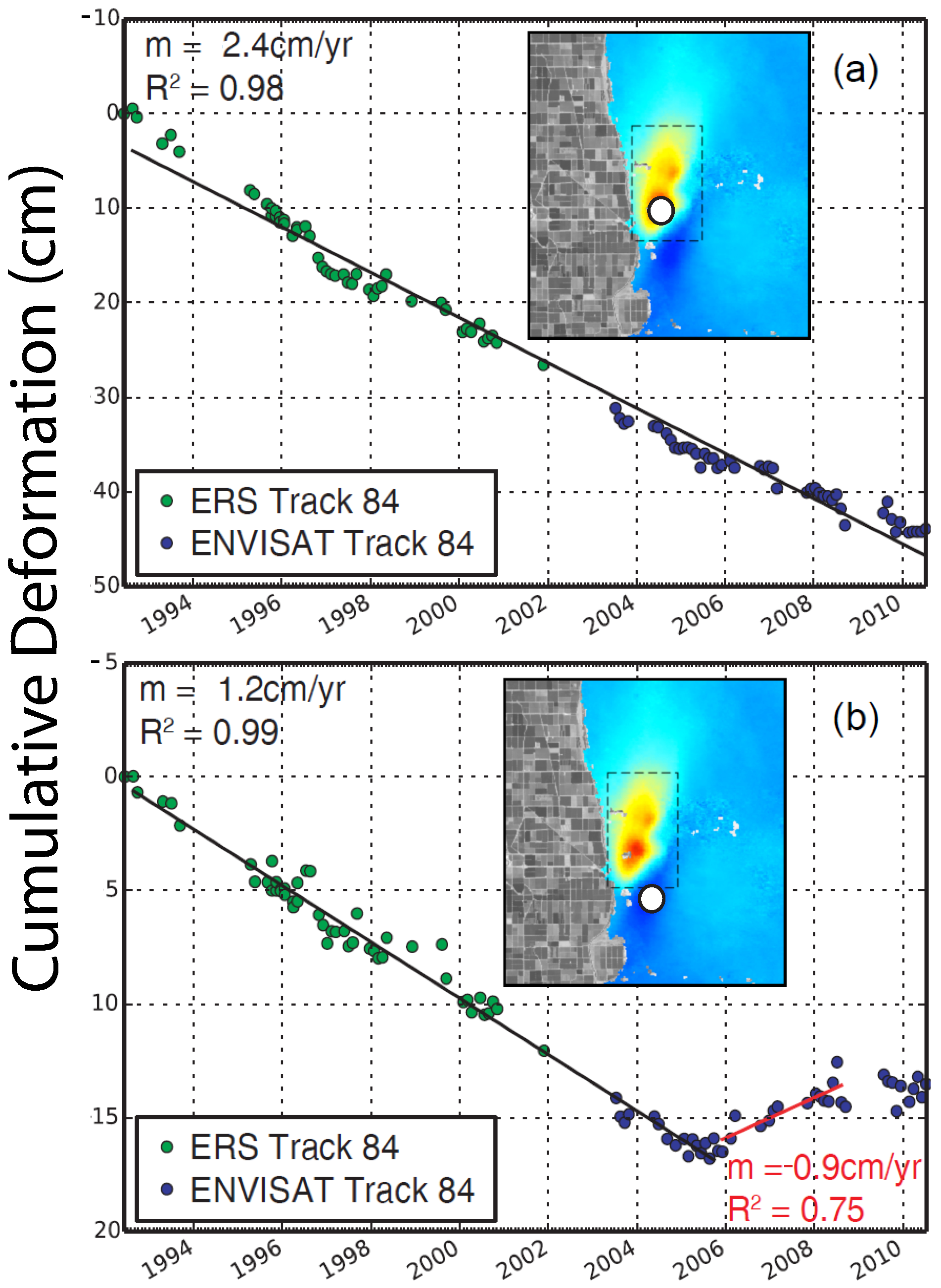
3.1.1. East Mesa, CA
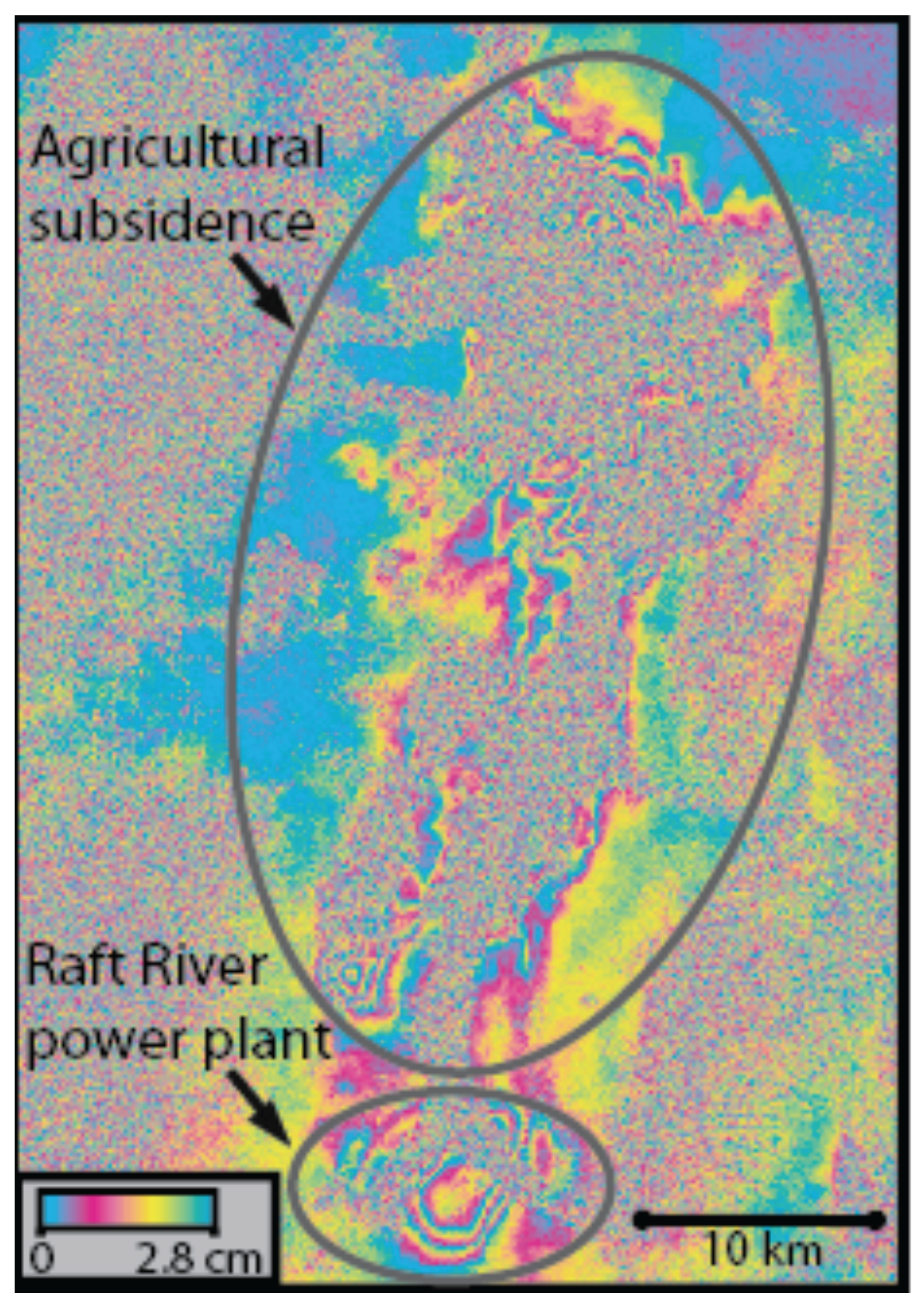
3.1.2. Raft River Valley, ID
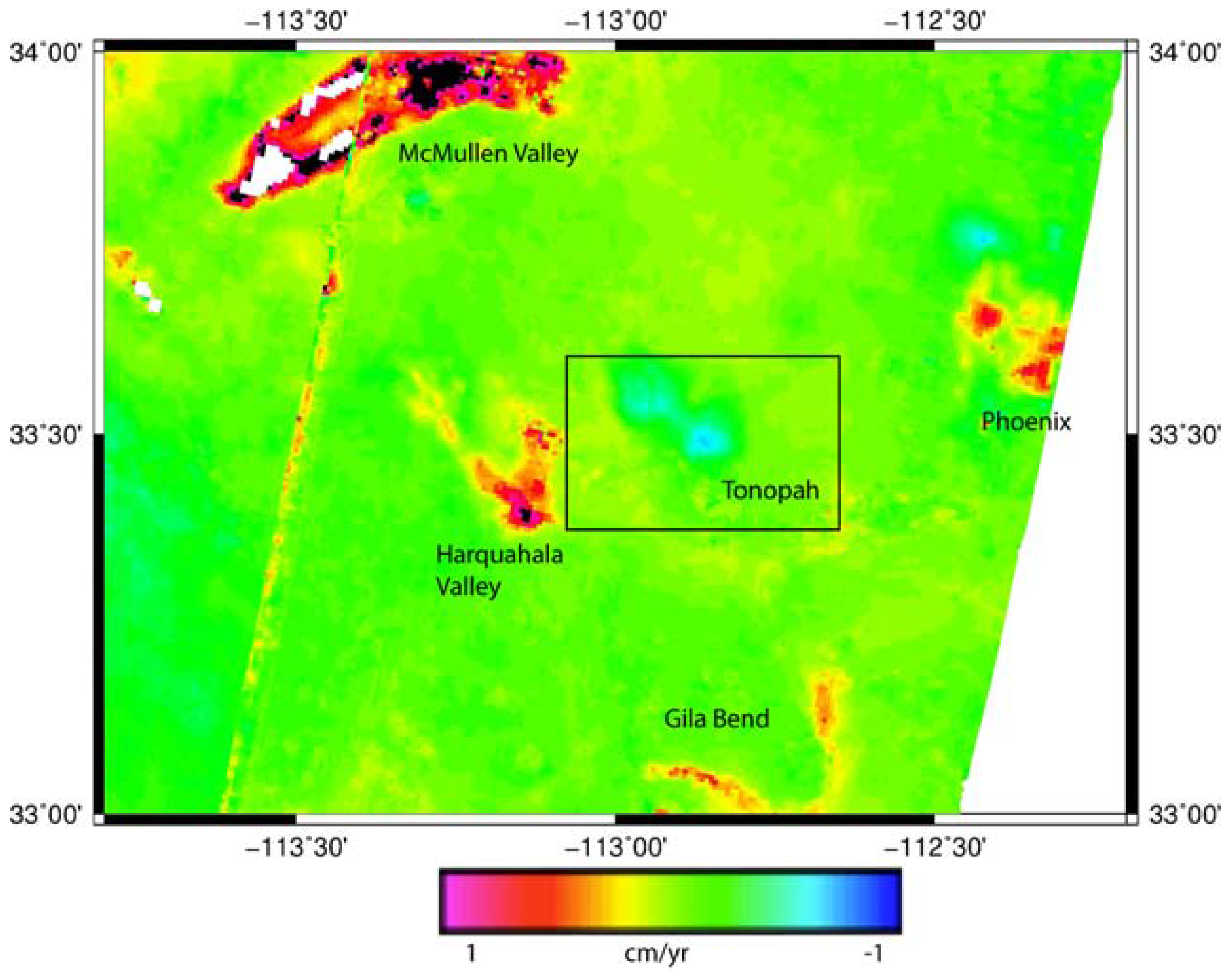
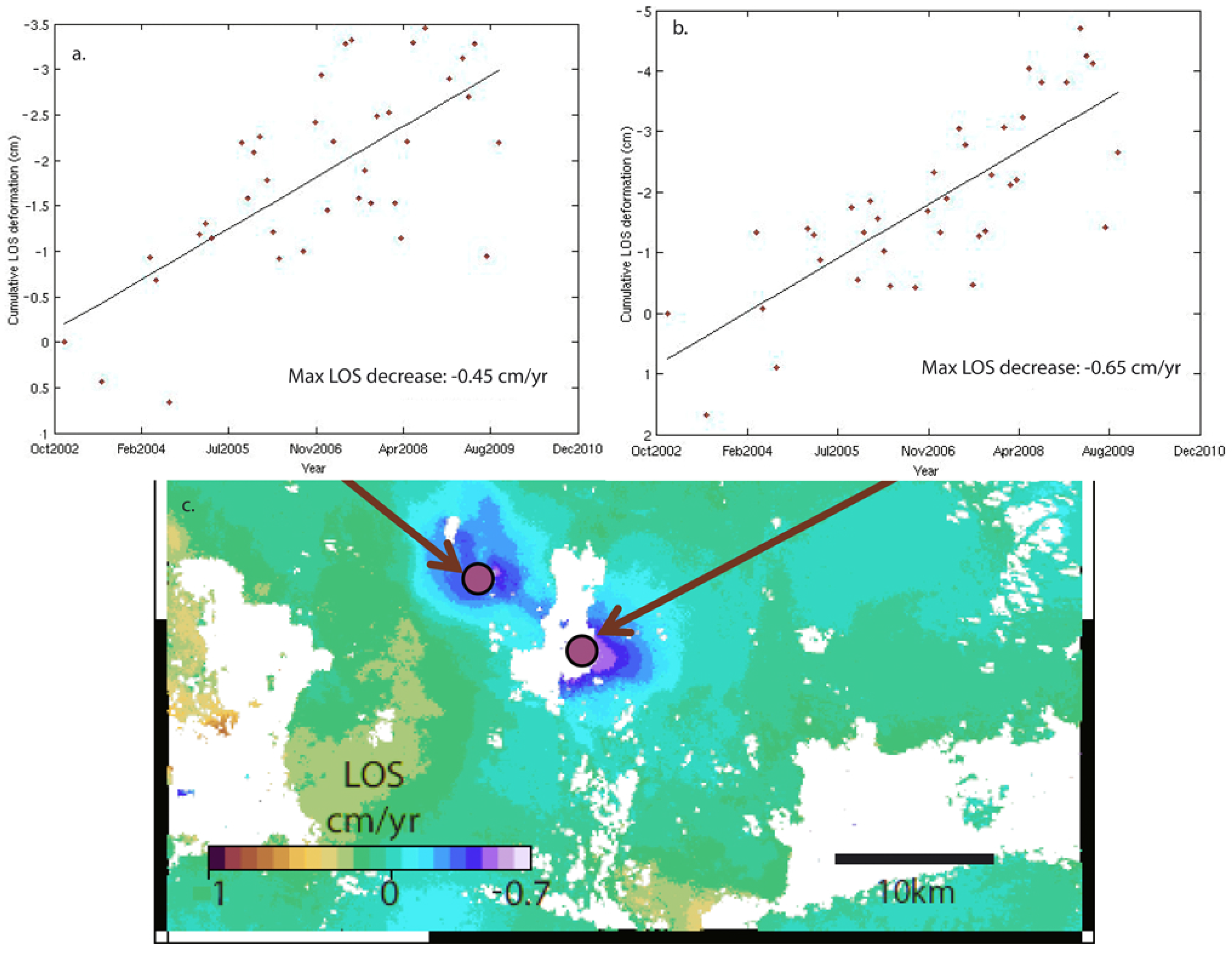
3.1.3. Tonopah, AZ
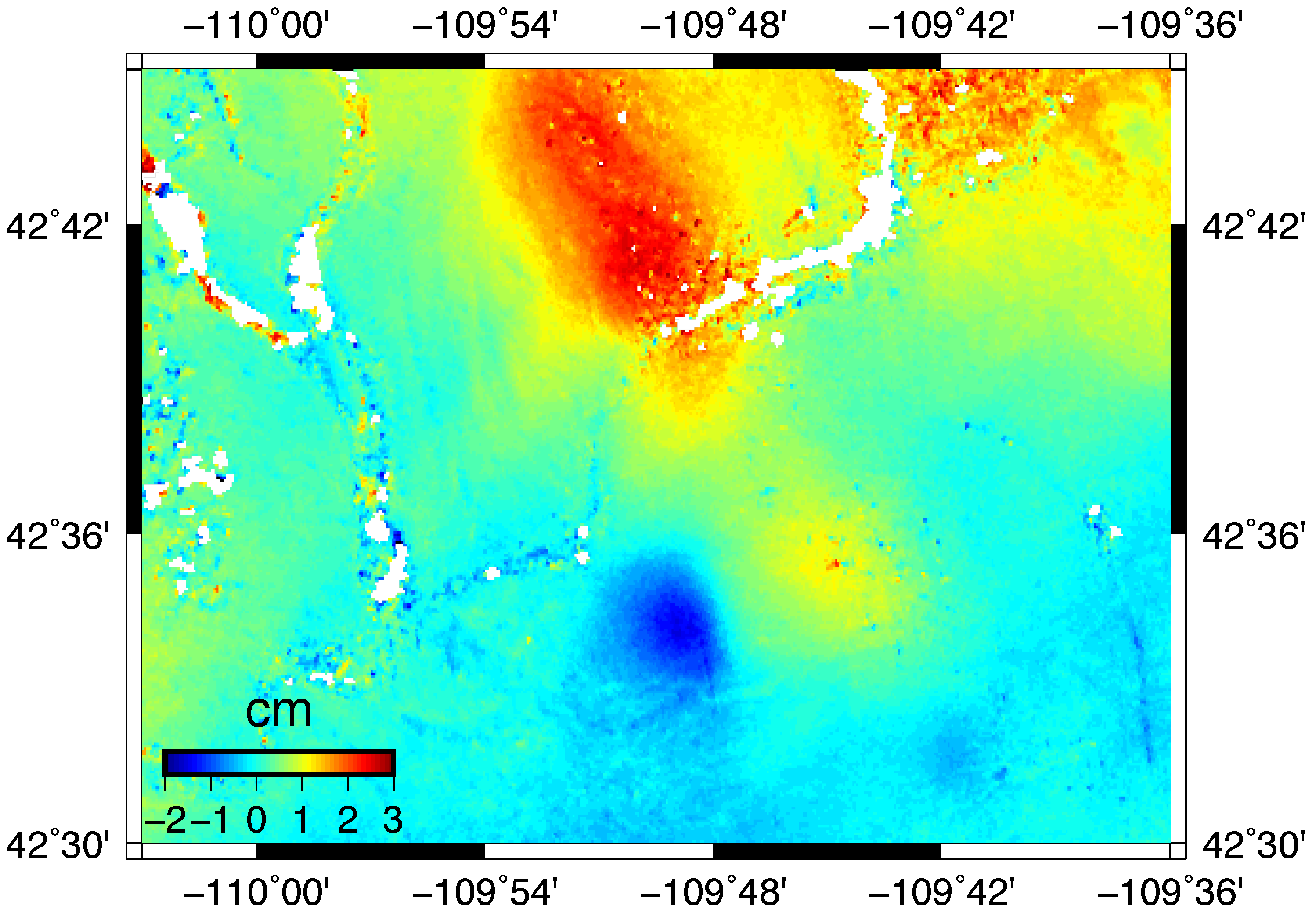
3.1.4. Jonah Field, WY
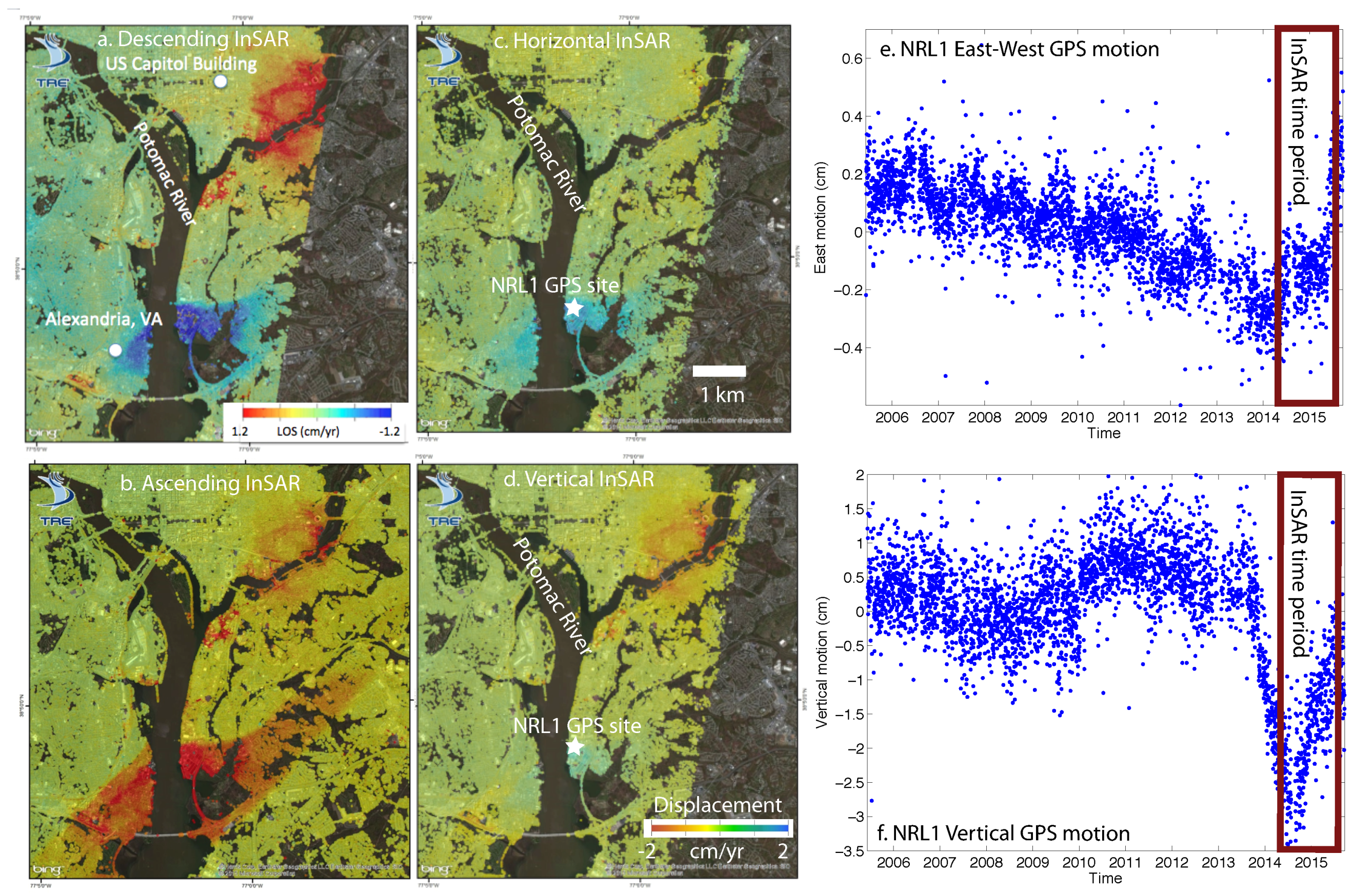
3.1.5. Washington, DC, and Alexandria, VA
3.2. Selected Non-Detections
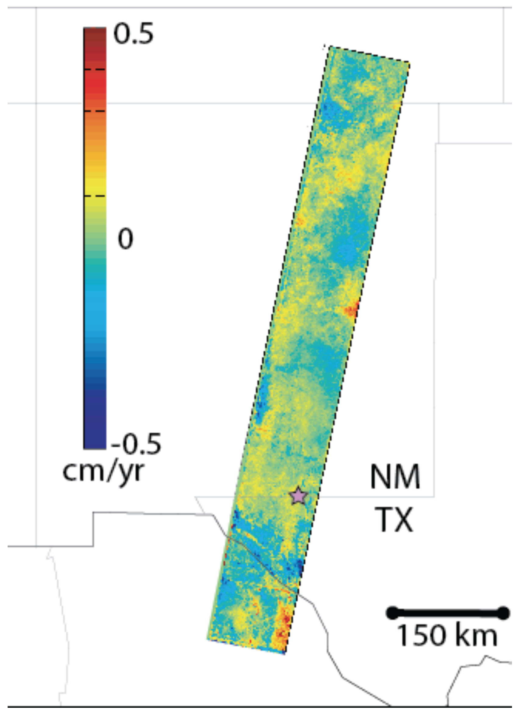
3.2.1. Diablo Plateau, Texas
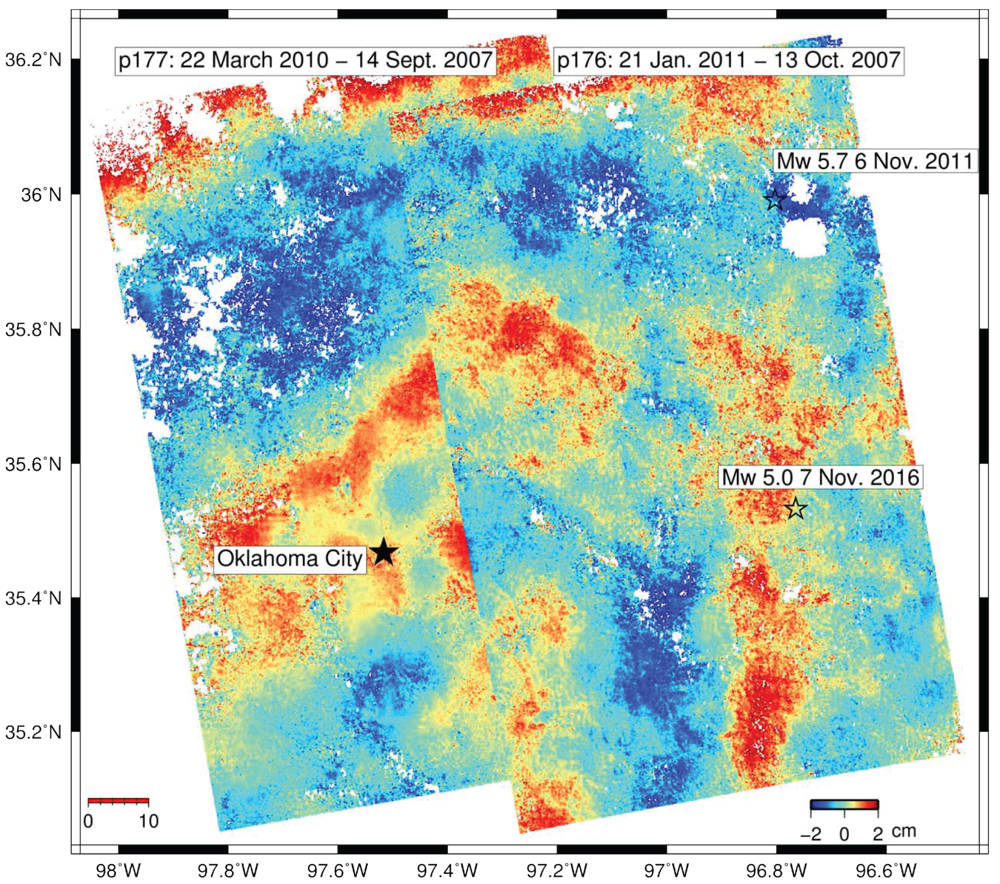
3.2.2. Oklahoma Injection
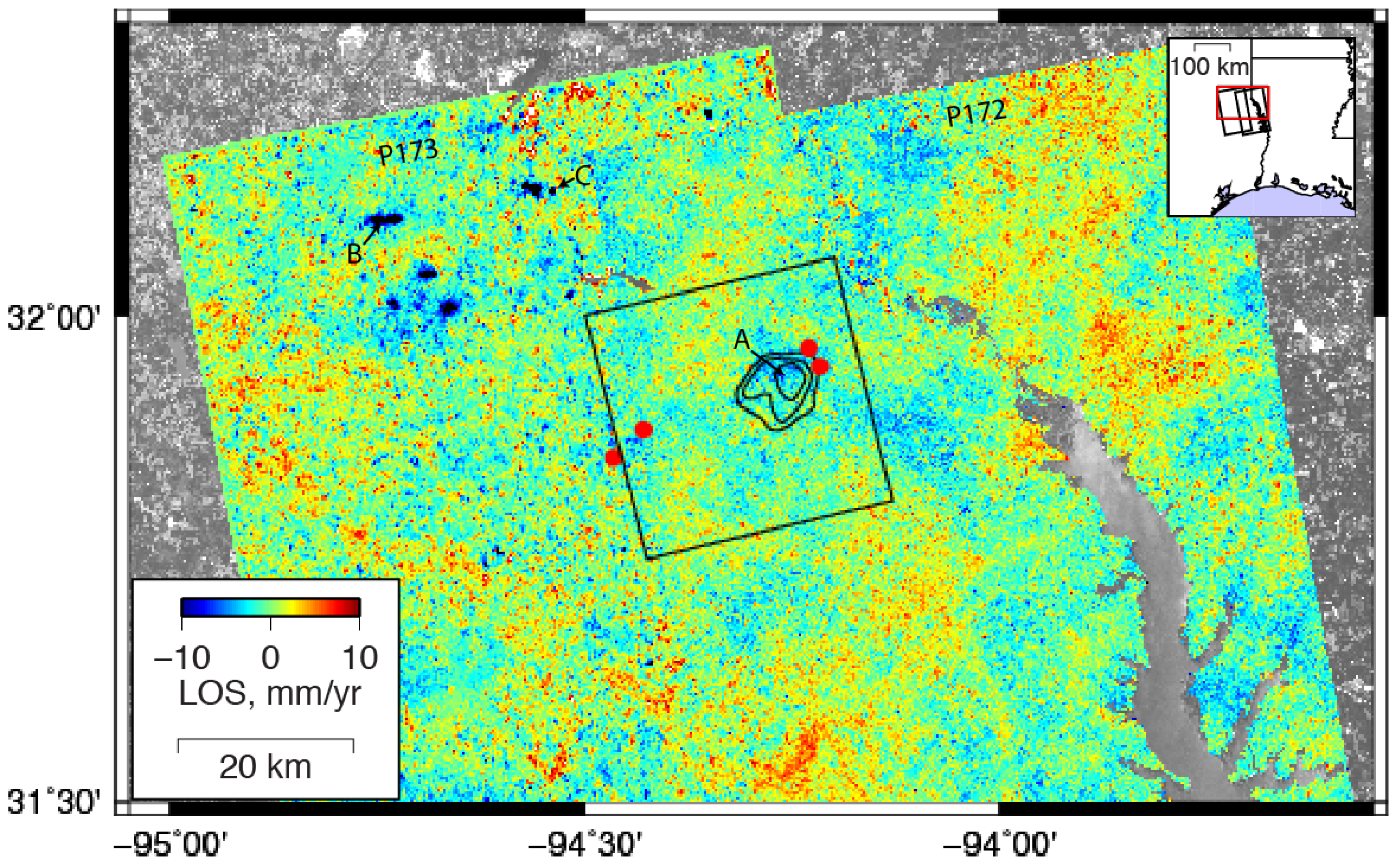
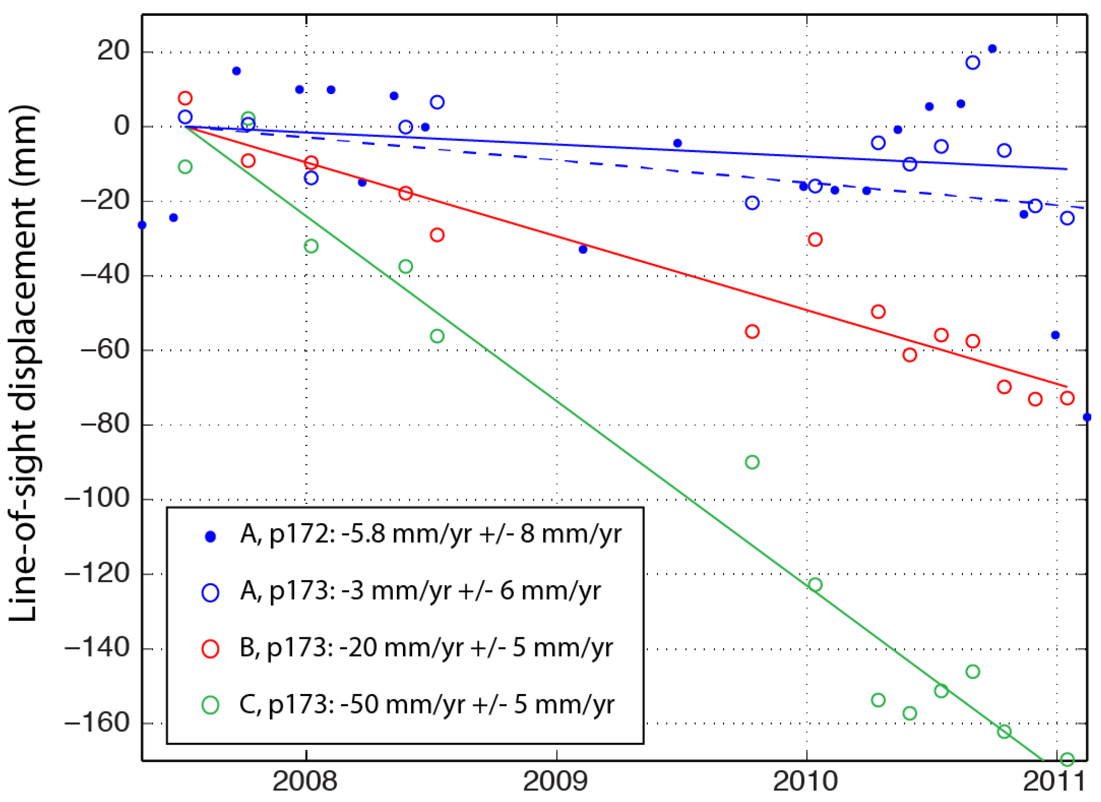
3.2.3. East Texas: New Detection and Non-Detection
3.3. GPS Contamination
4. Discussion
- To maximize areal coverage subject to fixed computational resources, we do not routinely process ascending and descending data over the same locations, which limits the ability to separate horizontal and vertical ground deformation.
- For the regional InSAR processing, temporal coverage is limited to 1992–2011 in the western US and 2006–2011 in other places. Deformation that might have occurred during other time periods would not be detected—for example, the deformation near Alexandria, VA, was not during this time interval and was not detected with the regional InSAR processing.
- Many areas of anthropogenic activity may be deforming at a level below our detection threshold, which is higher in the eastern U.S. For example, the deformation near Alexandria, VA, (Figure 13) would not have been detected by our analysis of the ALOS-1 data alone.
- Since deformation must be a few pixels in size to be detected, deformation must be a few hundred meters in size to be detectable with our approach.
5. Conclusions
Supplementary Materials
Acknowledgments
Author Contributions
Conflicts of Interest
References
- Vilardo, G.; Ventura, G.; Terranova, C.; Matano, F.; Nardò, S. Ground deformation due to tectonic, hydrothermal, gravity, hydrogeological, and anthropic processes in the Campania Region (Southern Italy) from Permanent Scatterers Synthetic Aperture Radar Interferometry. Remote Sens. Environ. 2009, 113, 197–212. [Google Scholar] [CrossRef]
- Tomás, R.; Romero, R.; Mulas, J.; Marturià, J.J.; Mallorquí, J.; Lopez-Sanchez, J.M.; Herrera, G.; Gutiérrez, F.; González, P.J.; Fernández, J.; et al. Radar interferometry techniques for the study of ground subsidence phenomena: A review of practical issues through cases in Spain. Environ. Earth Sci. 2014, 71, 163–181. [Google Scholar] [CrossRef] [Green Version]
- Mitigating Losses from Land Subsidence in the United States; Consensus Study Report; The National Academies Press: Washington, DC, USA, 1991.
- Galloway, D.; Jones, D.R.; Ingebritsen, S.E.E. Land Subsidence in the United States; US Geological Survey: Reston, VA, USA, 1999.
- Argus, D.F.; Heflin, M.B.; Peltzer, G.; Crampé, F.; Webb, F.H. Interseismic strain accumulation and anthropogenic motion in metropolitan Los Angeles. J. Geophys. Res. Solid Earth 2005, 110, 1–26. [Google Scholar] [CrossRef]
- Gourmelen, N.; Amelung, F.; Casu, F.; Manzo, M.; Lanari, R. Mining-related ground deformation in Crescent Valley, Nevada: Implications for sparse GPS networks. Geophys. Res. Lett. 2007, 34, 1–5. [Google Scholar] [CrossRef]
- González, P.J.; Tiampo, K.F.; Palano, M.; Cannavó, F.; Fernández, J. The 2011 Lorca earthquake slip distribution controlled by groundwater crustal unloading. Nat. Geosci. 2012, 5, 821–825. [Google Scholar] [CrossRef] [Green Version]
- Marshall, S.T.; Funning, G.J.; Owen, S.E. Fault slip rates and interseismic deformation in the western Transverse Ranges, California. J. Geophys. Res. Solid Earth 2013, 118, 4511–4534. [Google Scholar] [CrossRef]
- Trugman, D.T.; Borsa, A.A.; Sandwell, D.T. Did stresses from the Cerro Prieto Geothermal Field influence the El Mayor-Cucapah rupture sequence? Geophys. Res. Lett. 2014, 41, 8767–8774. [Google Scholar] [CrossRef]
- Fialko, Y.; Simons, M. Deformation and seismicity in the Coso geothermal area, Inyo County, California: Observations and modeling using satellite radar interferometry. J. Geophys. Res. B 2000, 105, 21781–21793. [Google Scholar] [CrossRef]
- Bell, J.W.; Amelung, F.; Ferretti, A.; Bianchi, M.; Novali, F. Permanent scatterer InSAR reveals seasonal and long-term aquifer-system response to groundwater pumping and artificial recharge. Water Resour. Res. 2008, 44. [Google Scholar] [CrossRef]
- Dixon, T.H.; Amelung, F.; Ferretti, A.; Novali, F.; Rocca, F.; Dokka, R.; Sella, G.; Kim, S.W.; Wdowinski, S.; Whitman, D. Space geodesy: Subsidence and flooding in New Orleans. Nature 2006, 441, 587–588. [Google Scholar] [CrossRef] [PubMed]
- Karegar, M.A.; Dixon, T.H.; Engelhart, S.E. Subsidence along the Atlantic Coast of North America: Insights from GPS and late Holocene relative sea level data. Geophys. Res. Lett. 2016, 43, 3126–3133. [Google Scholar] [CrossRef]
- Massonnet, D.; Holzer, T.; Vadon, H. Land subsidence caused by the East Mesa geothermal field, California, observed using SAR interferometry. Geophys. Res. Lett. 1997, 24, 901–904. [Google Scholar] [CrossRef]
- Amelung, F.; Galloway, D.; Bell, J.; Zebker, H.; Laczniak, R. Sensing the ups and downs of Las Vegas: InSAR reveals structural control of land subsidence and aquifer-system deformation. Geology 1999, 27, 483–486. [Google Scholar] [CrossRef]
- Bawden, G.W.; Thatcher, W.; Stein, R.S.; Hudnut, K.W.; Peltzer, G. Tectonic contraction across Los Angeles after removal of groundwater pumping effects. Nature 2001, 412, 812–815. [Google Scholar] [CrossRef] [PubMed]
- Miller, M.M.; Shirzaei, M. Spatiotemporal characterization of land subsidence and uplift in Phoenix using InSAR time series and wavelet transforms. J. Geophys. Res. Solid Earth 2015, 120, 5822–5842. [Google Scholar] [CrossRef]
- Ali, S.T.; Akerley, J.; Baluyut, E.C.; Davatzes, N.C.; Lopeman, J.; Moore, J.; Plummer, M.; Spielman, P.; Warren, I.; Feigl, K.L. Geodetic Measurements and Numerical Models of Deformation: Examples from Geothermal Fields in the Western United States. In Proceedings of the 41st Workshop on Geothermal Reservoir Engineering Stanford University, Stanford, CA, USA, 22–24 February 2016. [Google Scholar]
- Gabriel, A.K.; Goldstein, R.M.; Zebker, H.A. Mapping small elevation changes over large areas—Differential radar interferometry. J. Geophys. Res. 1989, 94, 9183–9191. [Google Scholar] [CrossRef]
- Prush, V.; Lohman, R. Forest Canopy Heights in the Pacific Northwest Based on InSAR Phase Discontinuities across Short Spatial Scales. Remote Sens. 2014, 6, 3210–3226. [Google Scholar] [CrossRef]
- Calais, E.; Han, J.; DeMets, C.; Nocquet, J. Deformation of the North American plate interior from a decade of continuous GPS measurements. J. Geophys. Res. Solid Earth 2006, 111. [Google Scholar] [CrossRef]
- Sella, G.F.; Stein, S.; Dixon, T.H.; Craymer, M.; James, T.S.; Mazzotti, S.; Dokka, R.K. Observation of glacial isostatic adjustment in “stable” North America with GPS. Geophys. Res. Lett. 2007, 34. [Google Scholar] [CrossRef]
- Peltier, W.; Argus, D.; Drummond, R. Space geodesy constrains ice age terminal deglaciation: The global ICE-6G_C (VM5a) model. J. Geophys. Res. Solid Earth 2015, 120, 450–487. [Google Scholar] [CrossRef]
- Bürgmann, R.; Rosen, P.A.; Fielding, E.J. Synthetic aperture radar interferometry to measure Earth’s surface topography and its deformation. Ann. Rev. Earth Planet. Sci. 2000, 28, 169–209. [Google Scholar] [CrossRef]
- Rosen, P.A.; Hensley, S.; Peltzer, G.; Simons, M. Updated Repeat Orbit Interferometry Package Released. EOS 2004, 85, 47. [Google Scholar] [CrossRef]
- Farr, T.G.; Rosen, P.A.; Caro, E.; Crippen, R.; Duren, R.; Hensley, S.; Kobrick, M.; Paller, M.; Rodriguez, E.; Roth, L.; et al. The Shuttle Radar Topography Mission. Rev. Geophys. 2007, 45, RG2004. [Google Scholar] [CrossRef]
- Gesch, D.; Oimoen, M.; Greenlee, S.; Nelson, C.; Steuck, M.; Tyler, D. The national elevation dataset. Photogramm. Eng. Remote Sens. 2002, 68, 5–32. [Google Scholar]
- Valentino, B.R. Application of InSAR to Salt Mine Subsidence. Master’s Thesis, Cornell University, Ithaca, NY, USA, 2016. [Google Scholar]
- Berardino, P.; Fornaro, G.; Lanari, R.; Sansosti, E. A new Algorithm for Surface Deformation Monitoring based on Small Baseline Differential SAR Interferograms. IEEE Trans. Geosci. Remote Sens. 2002, 40, 2375–2383. [Google Scholar] [CrossRef]
- Henderson, S.T.; Pritchard, M.E. Decadal volcanic deformation in the Central Andes Volcanic Zone revealed by InSAR time series. Geochem. Geophys. Geosyst. 2013, 14, 1358–1374. [Google Scholar] [CrossRef]
- Buckley, S.M.; Rosen, P.A.; Hensley, S.; Tapley, B.D. Land subsidence in Houston, Texas, measured by radar interferometry and constrained by extensometers. J. Geophys. Res. Solid Earth (1978–2012) 2003, 108. [Google Scholar] [CrossRef]
- Schmidt, D.A.; Bürgmann, R. Time-dependent land uplift and subsidence in the Santa Clara valley, California, from a large interferometric synthetic aperture radar data set. J. Geophys. Res. 2003, 108. [Google Scholar] [CrossRef]
- Meyer, F.; Hsiao, V.; Oommen, T.; Moruza, T. Using Interferometric Synthetic Aperture Radar for Network-Wide Transportation Infrastructure Monitoring. Presented at the TRB Webinar, Washington, DC, USA, 12 July 2016. [Google Scholar]
- Hoppe, E.; Bohane, A.; Falorni, G.; Bruckno, B.; Vaccari, A.; Meyer, F.; Pritchard, M. InSAR remote sensing for performance monitoring of transportation infrastructure at the network level. In Proceedings of the Transport Research Arena TRA2016, Warsaw, Poland, 18–21 April 2016. [Google Scholar]
- Hanssen, R.A. Radar Interferometry: Data Interpretation and Error Analysis; Kluwer Academic Publishers: Dordrecht, The Netherlands, 2001. [Google Scholar]
- Barnhart, W.D.; Lohman, R.B. Characterizing and estimating noise in InSAR and InSAR time series with MODIS. Geochem. Geophys. Geosyst. 2013, 14, 4121–4132. [Google Scholar] [CrossRef]
- Greene, F. Surface Deformation Measured with Interferometric Synthetic Aperture Radar: Case Studies of Basin and Range and Garlock-San Andreas Fault. Ph.D. Thesis, University of Miami, Coral Gables, FL, USA, 2014. [Google Scholar]
- Massonnet, D.; Feigl, K. Discrimination of geophysical phenomena in satellite radar interferograms. Geophys. Res. Lett. 1995, 22, 1537–1540. [Google Scholar] [CrossRef]
- Pritchard, M.E.; Simons, M.; Rosen, P.; Hensley, S.; Webb, F. Co-seismic slip from the 1995 July 30 Mw = 8.1 Antofagasta, Chile, earthquake as constrained by InSAR and GPS observations. Geophys. J. Int. 2002, 150, 362–376. [Google Scholar] [CrossRef]
- Zebker, H.A.; Villasenor, J. Decorrelation in interferometric radar echoes. IEEE Trans. Geosci. Remote Sens. 1992, 30, 950–959. [Google Scholar] [CrossRef]
- Malinverni, E.; Sandwell, D.; Tassetti, A.; Cappelletti, L. Decorrelation of L-Band and C-Band Interferometry to volcanic risk prevention. In Proceedings of the SPIE Remote Sensing, International Society for Optics and Photonics, Dresden, Germany, 17 October 2013; p. 88910B. [Google Scholar]
- Baxter, M.A.; Graves, C.E.; Moore, J.T. A climatology of snow-to-liquid ratio for the contiguous United States. Weather Forecast. 2005, 20, 729–744. [Google Scholar] [CrossRef]
- Prush, V.B.; Lohman, R.B. Time-Varying Elevation Change at the Centralia Coal Mine in Centralia, Washington (USA), Constrained with InSAR, ASTER, and Optical Imagery. IEEE J. Sel. Top. Appl. Earth Obs. Remote Sens. 2015, 8, 919–925. [Google Scholar] [CrossRef]
- Finnegan, N.J.; Pritchard, M.E.; Lohman, R.B.; Lundgren, P.R. Constraints on surface deformation in the Seattle, WA urban corridor from satellite radar interferometry time series analysis, Geophys. J. Int. 2008, 174, 29–41. [Google Scholar] [CrossRef]
- Fialko, Y.; Simons, M. Evidence for on-going inflation of the Socorro magma body, New Mexico, from interferometric synthetic aperture radar imaging. Geophys. Res. Lett. 2001, 28, 3549–3552. [Google Scholar] [CrossRef]
- Philibosian, B.; Simons, M. A survey of volcanic deformation on Java using ALOS PALSAR interferometric time series. Geochem. Geophys. Geosyst. 2011, 12, Q110044. [Google Scholar] [CrossRef]
- Ebmeier, S.; Biggs, J.; Mather, T.; Amelung, F. On the lack of InSAR observations of magmatic deformation at Central American volcanoes. J. Geophys. Res. Solid Earth 2013, 118, 2571–2585. [Google Scholar] [CrossRef]
- Bekaert, D.; Hamlington, B.; Buzzanga, B.; Jones, C. Spaceborne Synthetic Aperture Radar Survey of Subsidence in Hampton Roads, Virginia (USA). Sci. Rep. 2017, 7, 14752. [Google Scholar] [CrossRef] [PubMed]
- EIA. U.S. Energy Information Agency, Active Coal Mines, Surface and Underground. Available online: https://www.eia.gov/maps/layer_info-m.php (accessed on 2 June 2017).
- Han, J.Y.; Forster, R.R.; Moser, D.E.; Ford, A.L.J.; Ramírez-Hernández, J.; Tiampo, K.F. The spatial and temporal subsidence variability of the East Mesa Geothermal Field, California, USA, and its potential impact on the All American Canal System. Int. J. Remote Sens. 2011, 32, 3427–3449. [Google Scholar] [CrossRef]
- Lofgren, B.E. Measuring ground movement in geothermal areas of Imperial Valley, California. In Proceedings of the Jet Propulsion Laboratory-National Science Foundation Geothermal Energy Conference, Pasadena, CA, USA, 23–25 September 1974; pp. 128–138. [Google Scholar]
- Lofgren, B.E. Measured crustal deformation in Imperial Valley, California. Geothermics 1979, 8, 267–272. [Google Scholar] [CrossRef]
- Eneva, M.; Adams, D.; Falorni, G.; Morgan, J. Surface deformation in Imperial Valley, CA, from satellite radar interferometry. Geotherm. Resour. Counc. Trans. 2012, 36, 1339–1344. [Google Scholar]
- Eneva, M.; Adams, D.; Falorni, G.; Morgan, J. Applications of radar interferometry to detect surface deformation in geothermal areas of Imperial Valley in southern California. In Proceedings of the 38th Workshop on Geothermal Reservoir Engineering, Stanford, CA, USA, 11–13 February 2013. [Google Scholar]
- Lofgren, B.E. Land Subsidence and Tectonism, Raft River Valley, Idaho; U.S. Geological Survey: Reston, VA, USA, 1975; p. 21.
- ADWR. Arizona Department of Water Resources, Land Subsidence in Arizona. Available online: http://www.azwater.gov/AzDWR/Hydrology/Geophysics/LandSubsidenceInArizona.htm (accessed on 8 April 2015).
- CAP Project. Tonopah Desert Recharge Project. Available online: http://www.cap-az.com/index.php/departments/recharge-program/tonopah-desert (accessed on 10 January 2017).
- Pinedale Anticline Project Office, Pinedale, Wyoming. Available online: http://www.wy.blm.gov/jio-papo/papo/index.htm (accessed on 10 January 2017).
- Encana, USA Division. Annual Information Form. Available online: https://www.encana.com/pdf/investors/financial/annual-reports/2008/p006996.pdf (accessed on 11 December 2016).
- District of Columbia Water and Sewer Authority. DC Clean Rivers Project—Division A, Blue Plains Tunnel. Available online: https://www.dcwater.com/workzones/projects/pdfs/blueplains_tunnel.pdf (accessed on 26 May 2011).
- Blewitt, G.; Kreemer, C.; Hammond, W.C.; Goldfarb, J.M. Terrestrial reference frame NA12 for crustal deformation studies in North America. J. Geodyn. 2013, 72, 11–24. [Google Scholar] [CrossRef]
- Blewitt, G.; Kreemer, C.; Hammond, W.C.; Gazeaux, J. MIDAS robust trend estimator for accurate GPS station velocities without step detection. J. Geophys. Res. Solid Earth 2016, 121, 2054–2068. [Google Scholar] [CrossRef] [PubMed]
- Reilinger, R.; Brown, L.; Powers, D. New evidence for tectonic uplift in the Diablo Plateau region, west Texas. Geophys. Res. Lett. 1980, 7, 181–184. [Google Scholar] [CrossRef]
- Keranen, K.M.; Savage, H.M.; Abers, G.A.; Cochran, E.S. Potentially induced earthquakes in Oklahoma, USA: Links between wastewater injection and the 2011 Mw 5.7 earthquake sequence. Geology 2013, 41, 699–702. [Google Scholar] [CrossRef]
- Samsonov, S.; Beavan, J.; González, P.J.; Tiampo, K.; Fernández, J. Ground deformation in the Taupo Volcanic Zone, New Zealand, observed by ALOS PALSAR interferometry. Geophys. J. Int. 2011, 187, 147–160. [Google Scholar] [CrossRef] [Green Version]
- Barnhart, W.D.; Benz, H.M.; Hayes, G.P.; Rubinstein, J.L.; Bergman, E. Seismological and geodetic constraints on the 2011 Mw 5.3 Trinidad, Colorado earthquake and induced deformation in the Raton Basin. J. Geophys. Res. Solid Earth 2014, 119, 7923–7933. [Google Scholar] [CrossRef]
- Chaussard, E.; Amelung, F.; Aoki, Y. Characterization of open and closed volcanic systems in Indonesia and Mexico using InSAR time series. J. Geophys. Res. Solid Earth 2013, 118, 3957–3969. [Google Scholar] [CrossRef]
- Shirzaei, M.; Ellsworth, W.L.; Tiampo, K.F.; González, P.J.; Manga, M. Surface uplift and time-dependent seismic hazard due to fluid injection in eastern Texas. Science 2016, 353, 1416–1419. [Google Scholar] [CrossRef] [PubMed]
- Ali, S.T.; Davatzes, N.C.; Feigl, K.L.; Wang, H.F.; Foxall, W.; Mellors, R.J.; Akerley, J.; Zemach, E.; Spielman, P. Deformation at Brady Hot Springs geothermal field measured by time series analysis of InSAR data. In Proceedings of the Fourtieth Workshop on Geothermal Reservoir Engineering Stanford University, Stanford, CA, USA, 26–28 January 2015; Volume 40, pp. 26–28. [Google Scholar]
- Im, K.; Elsworth, D.; Guglielmi, Y.G.; Mattioli, G.S. Use of Geodesy to Discriminate Deformation Mechanics in Geothermal Reservoirs. In Proceedings of the 9th US Rock Mechanics/Geomechanics Symposium, San Francisco, CA, USA, 28 June–1 July 2015. [Google Scholar]
- Barra, A.; Solari, L.; Béjar-Pizarro, M.; Monserrat, O.; Bianchini, S.; Herrera, G.; Crosetto, M.; Sarro, R.; González-Alonso, E.; Mateos, R.M.; et al. A Methodology to Detect and Update Active Deformation Areas Based on Sentinel-1 SAR Images. Remote Sens. 2017, 9, 1002. [Google Scholar] [CrossRef]
| Track or Path | Satellite | # Interferograms | Interferogram Date Range |
|---|---|---|---|
| 12 | ERS | 90 | 920815–960429 |
| 55 | ERS | 251 | 920609–001103 |
| 84 | ERS | 307 | 920611–011125 |
| 98 | ERS | 160 | 920612–001211 |
| 213 | ERS | 337 | 920620–011204 |
| 234 | ERS | 3 | 950531–960515 |
| 241 | ERS | 79 | 920622–000629 |
| 277 | ERS | 78 | 920521–001915 |
| 284 | ERS | 118 | 921112–011209 |
| 356 | ERS | 354 | 920421–040820 |
| 399 | ERS | 478 | 920424–000327 |
| 442 | ERS | 201 | 920601–041209 |
| 5 | Envisat | 8 | 050816–080527 |
| 41 | Envisat | 210 | 040902–101021 |
| 55 | Envisat | 28 | 040730–100430 |
| 84 | Envisat | 106 | 041104–100711 |
| 98 | Envisat | 135 | 060807–110731 |
| 141 | Envisat | 25 | 050127–100923 |
| 184 | Envisat | 60 | 041114–100711 |
| 213 | Envisat | 146 | 030722–100928 |
| 227 | Envisat | 163 | 041124–100929 |
| 234 | Envisat | 3 | 040219–060330 |
| 241 | Envisat | 7 | 040916–100930 |
| 256 | Envisat | 177 | 040326–101001 |
| 270 | Envisat | 315 | 031213–101002 |
| 277 | Envisat | 222 | 040118–101003 |
| 284 | Envisat | 1 | 040919–050313 |
| 299 | Envisat | 220 | 031006–101004 |
| 306 | Envisat | 288 | 031216–101005 |
| 356 | Envisat | 99 | 041029–100903 |
| 399 | Envisat | 115 | 050214–090817 |
| 442 | Envisat | 69 | 040826–110225 |
| 197 | ALOS-1 | 42 | 060814–110225 |
| 211 | ALOS-1 | 43 | 070107–071203 |
| 84 | ERS | 289 (49 dates) | 920611–011125 |
| 84 | Envisat | 359 (47 dates) | 030713–100815 |
| 306 | Envisat | 272 (35 dates) | 031216–101005 |
| 211 | ALOS-1 | 93 (16 dates) | 060522–110118 |
| Track or Path | Satellite | # Interferograms | Date or Dates of Interferograms |
|---|---|---|---|
| 125 | ALOS-1 | 1 | 110128–080606 |
| 127 | ALOS-1 | 1 | 100228–070823 |
| 129 | ALOS-1 | 1 | 100403–070926 |
| 130 | ALOS-1 | 1 | 100420–071013 |
| 131 | ALOS-1 | 1 | 100622–071215 |
| 133 | ALOS-1 | 1 | 100626–080118 |
| 134 | ALOS-1 | 1 | 100327–070919 |
| 135 | ALOS-1 | 1 | 110114–080523 |
| 137 | ALOS-1 | 17 | 12/2006–1/2011 |
| 138 | ALOS-1 | 10 | 5/2007–9/2010 |
| 139 | ALOS-1 | 1 | 100620–071213 |
| 141 | ALOS-1 | 1 | 100308–071016 |
| 143 | ALOS-1 | 32 | 1/2007–1/2011 |
| 145 | ALOS-1 | 1 | 101231–080509 |
| 147 | ALOS-1 | 1 | 100418–071026 |
| 149 | ALOS-1 | 3 | 1/2008–1/2011 |
| 151 | ALOS-1 | 1 | 110110–080519 |
| 153 | ALOS-1 | 1 | 101229–080519 |
| 155 | ALOS-1 | 1 | 100616–071209 |
| 159 | ALOS-1 | 3 | 5/2008–1/2011 |
| 161 | ALOS-1 | 1 | 100626–071219 |
| 163 | ALOS-1 | 1 | 110130–080606 |
| 167 | ALOS-1 | 1 | 100103–070928 |
| 169 | ALOS-1 | 1 | 100324–071217 |
| 171 | ALOS-1 | 1 | 100612–071205 |
| 173 | ALOS-1 | 1 | 100716–080108 |
| 175 | ALOS-1 | 1 | 100519–071227 |
| 176 | ALOS-1 | 21 | 7/2007–1/2011 |
| 177 | ALOS-1 | 8 | 9/2007–12/2010 |
| 179 | ALOS-1 | 1 | 100610–071018 |
| 181 | ALOS-1 | 1 | 100226–080106 |
| 185 | ALOS-1 | 1 | 100620–071213 |
| ascending | CSK | 40 | 2/2013–8/2015 |
| descending | CSK | 28 | 3/2014–6/2015 |
| GPS Station ID | Location | Lat, Lon | Figure |
|---|---|---|---|
| NRL1 | Naval Research Lab, Washington, DC | 38.8207, −77.0244 | Figure 13 |
| COSO | China Lake, CA | 35.9823, −117.8089 | Figure S2 |
| UNR1 | Las Vegas, NV | 36.246, −115.243 | Figure S3 |
| P500 | EMGF, CA | 32.690 −115.300 | Figure S4 |
| SUR1 | Salt Lake City, UT | 40.675, −111.892 | Figure S6 |
| P226 | San Jose, CA | 37.337, −121.826 | |
| P015 | Show Low, AZ | 34.264, −110.009 | |
| P148 | Susanville, CA | 40.419, −120.806 | |
| P105 | Delta Muni, UT | 39.388, −112.504 | Figure S26 |
| LACR | Lamo Crk, NV | 40.851, −115.704 | Figure S27 |
| LLAS | Lake Los Angeles School, CA | 34.586, −117.838 | Figure S37 |
| SONC | Grass Valley, NV | 40.853, −117.728 | Figure S32 |
| PARO | Near Little Salt Lake, UT | 38.033, −112.676 | Figure S20 |
| P056 | Poterville, CA | 36.027, −119.063 | Figure S11 |
| LEMA | Lemoore, CA | 36.292, −119.782 | Figure S11 |
| CRCN | Corcoran, CA | 36.114, −119.568 | Figure S11 |
| P564 | Lerdo Overpass, CA | 35.499, −119.535 | Figure S11 |
© 2017 by the authors. Licensee MDPI, Basel, Switzerland. This article is an open access article distributed under the terms and conditions of the Creative Commons Attribution (CC BY) license (http://creativecommons.org/licenses/by/4.0/).
Share and Cite
Semple, A.G.; Pritchard, M.E.; Lohman, R.B. An Incomplete Inventory of Suspected Human-Induced Surface Deformation in North America Detected by Satellite Interferometric Synthetic-Aperture Radar. Remote Sens. 2017, 9, 1296. https://doi.org/10.3390/rs9121296
Semple AG, Pritchard ME, Lohman RB. An Incomplete Inventory of Suspected Human-Induced Surface Deformation in North America Detected by Satellite Interferometric Synthetic-Aperture Radar. Remote Sensing. 2017; 9(12):1296. https://doi.org/10.3390/rs9121296
Chicago/Turabian StyleSemple, Alana G., Matthew E. Pritchard, and Rowena B. Lohman. 2017. "An Incomplete Inventory of Suspected Human-Induced Surface Deformation in North America Detected by Satellite Interferometric Synthetic-Aperture Radar" Remote Sensing 9, no. 12: 1296. https://doi.org/10.3390/rs9121296
APA StyleSemple, A. G., Pritchard, M. E., & Lohman, R. B. (2017). An Incomplete Inventory of Suspected Human-Induced Surface Deformation in North America Detected by Satellite Interferometric Synthetic-Aperture Radar. Remote Sensing, 9(12), 1296. https://doi.org/10.3390/rs9121296


