Polarimetric ALOS PALSAR Time Series in Mapping Biomass of Boreal Forests


Abstract
:
1. Introduction
2. Main PolSAR Concepts in the Context of the Study
- Backscattering coefficients (in dB) at HH, VV and HV polarizations. The corresponding expressions are given as
- Total backscattered power (in dB), which can be calculated based on span of coherence/covariance matrix.
- Polarimetric coherence between two co-polarization channels. Both magnitude and phase are important here, as they provide degree of correlation and HH-VV phase difference.
- Surface scattering fraction, given in [47] as
- Even-bounce scattering fraction, which can be defined as a ratio:
- Radar Vegetation Index (RVI) given aswhere typically a = 8, but can be adjusted to cover the dynamic range from 0 to 1. It was introduced in [48] with a goal of deriving a seasonally stable polarimetric descriptor for vegetated areas, but never really tested in forest biomass estimation. In forested terrain, it can be considered as a relative volume scattering contribution to the total backscattered power.
- Canopy Scattering Index defined asand its modification (or supplement)
3. Data and Methods
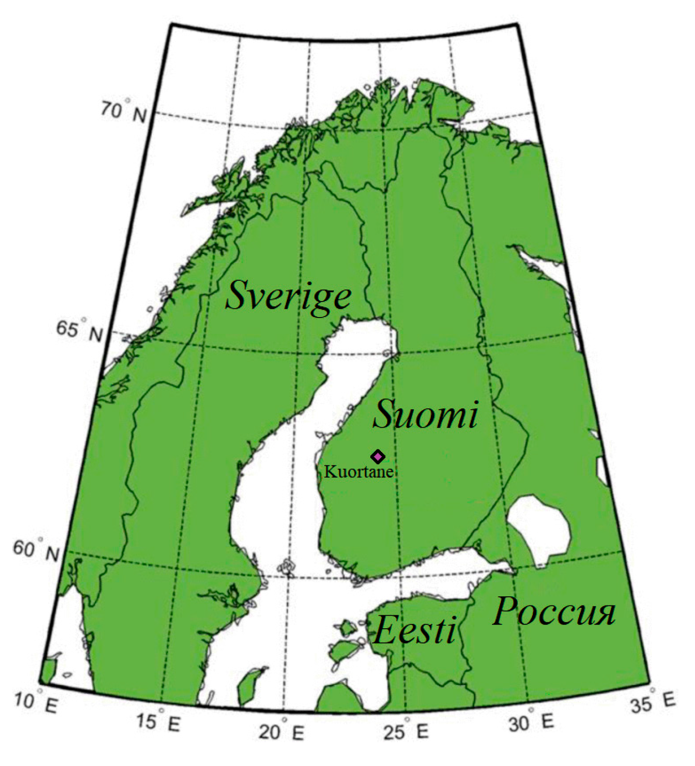
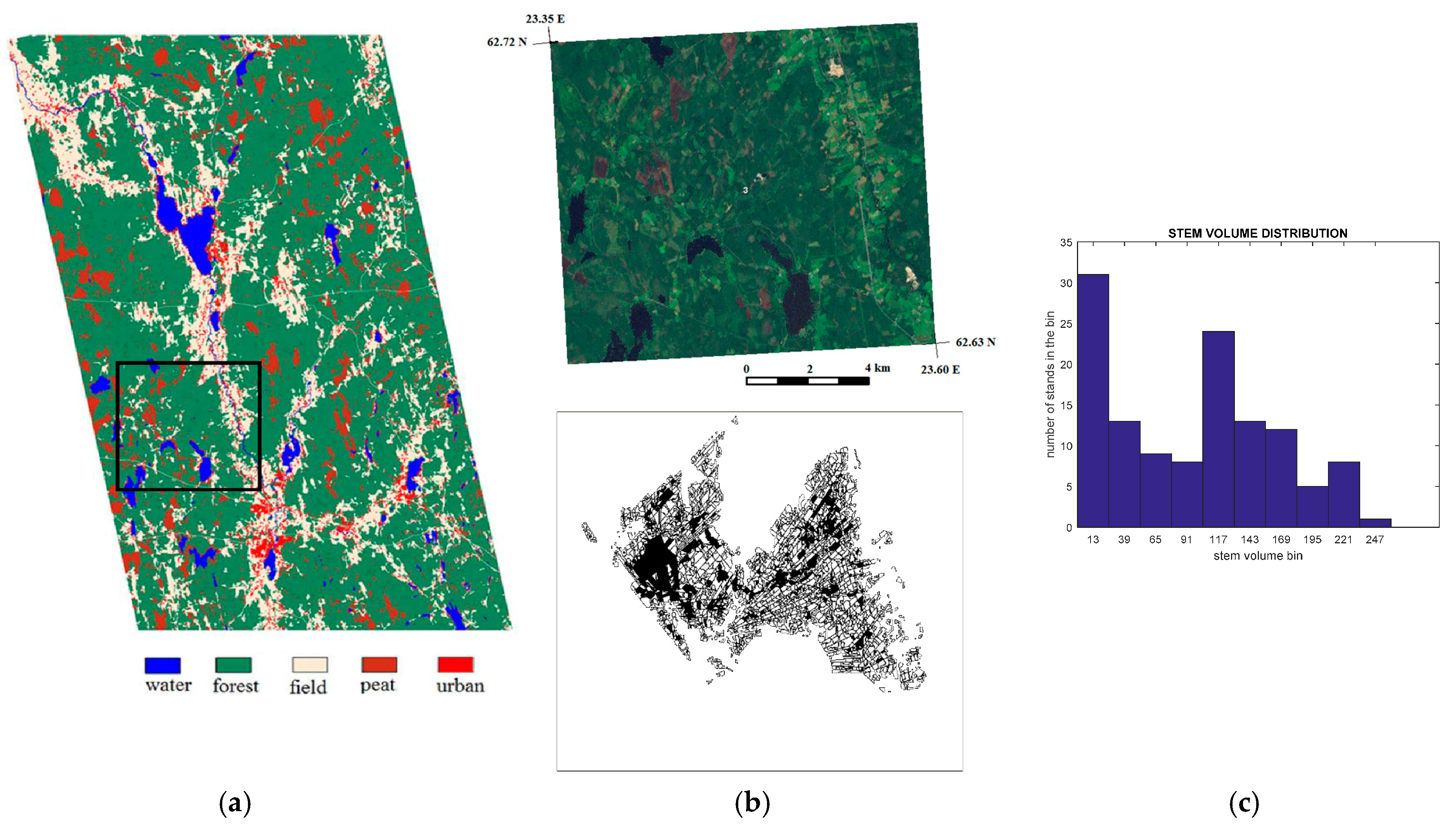
3.1. Study Site and In Situ Data
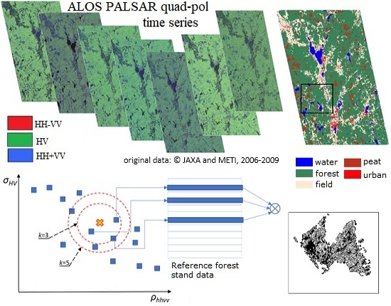
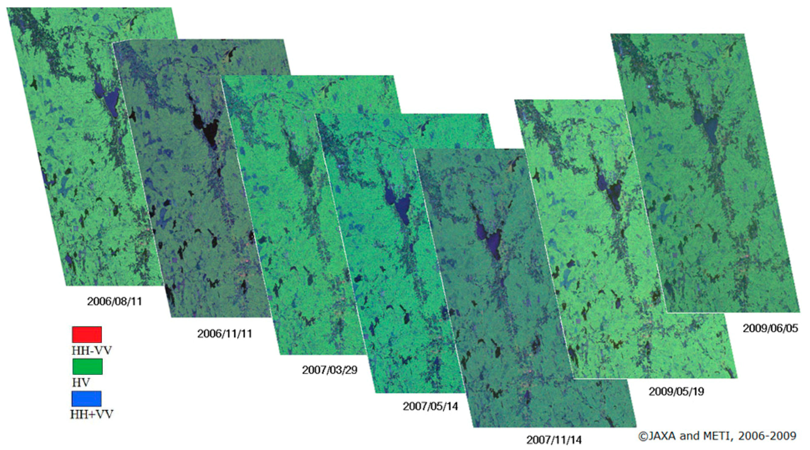
3.2. SAR Data
3.3. Reference Data
3.4. PolSAR Data Pre-Processing
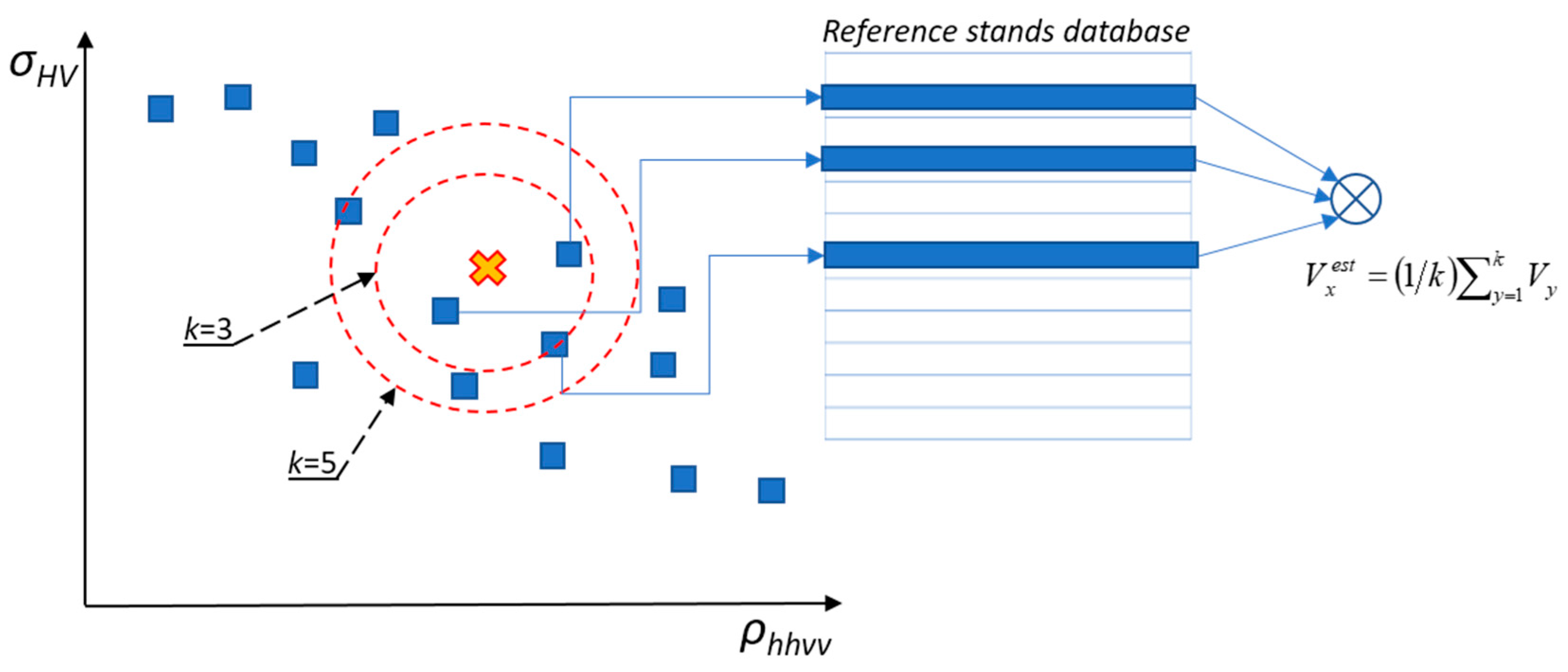
3.5. SAR Based Estimation of Stem Volume
| Algorithm 1 kNN regression approach |
|
3.6. Multi-Scene Aggregation
3.7. Accuracy Analysis
4. Results
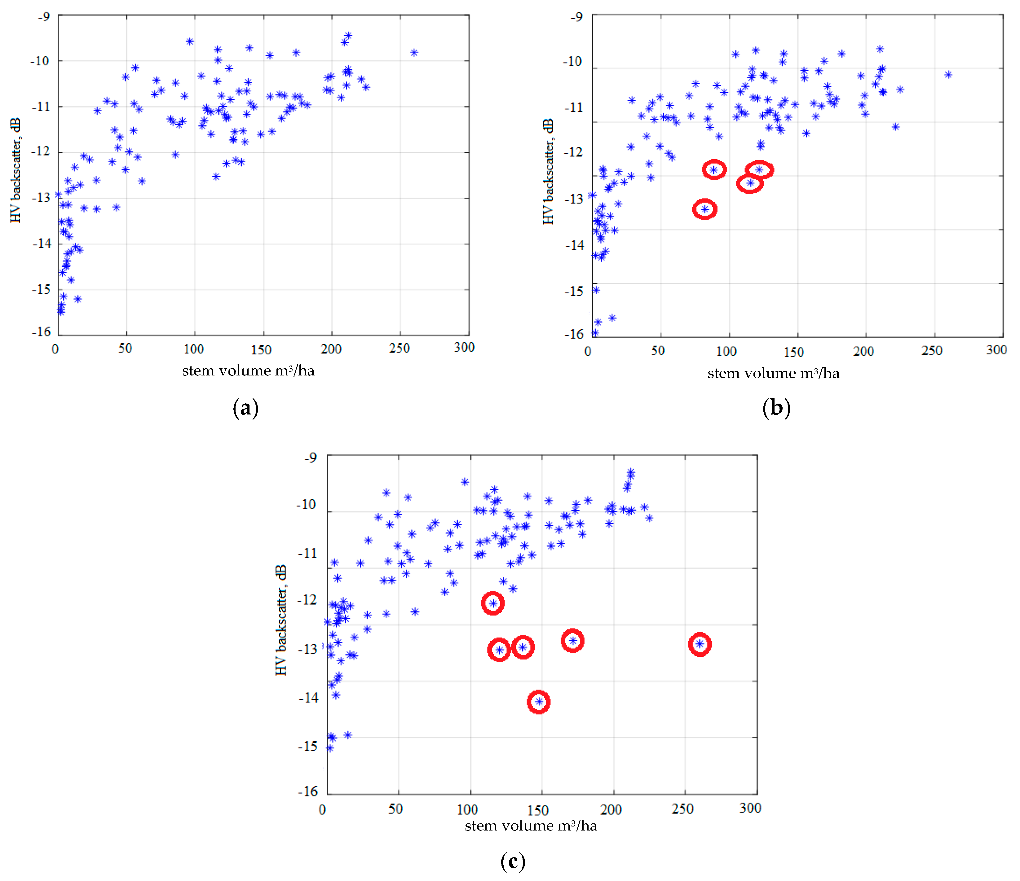
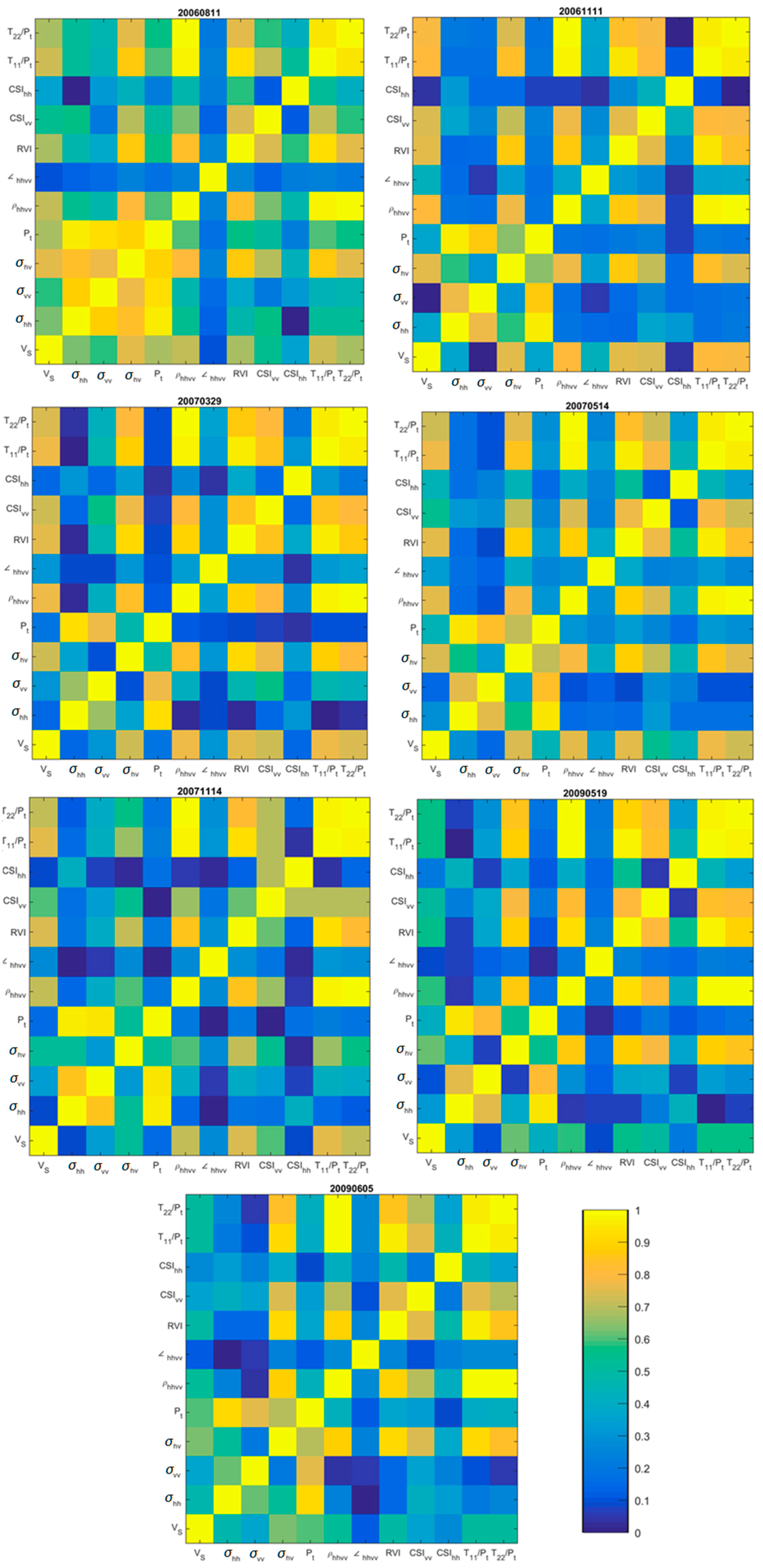
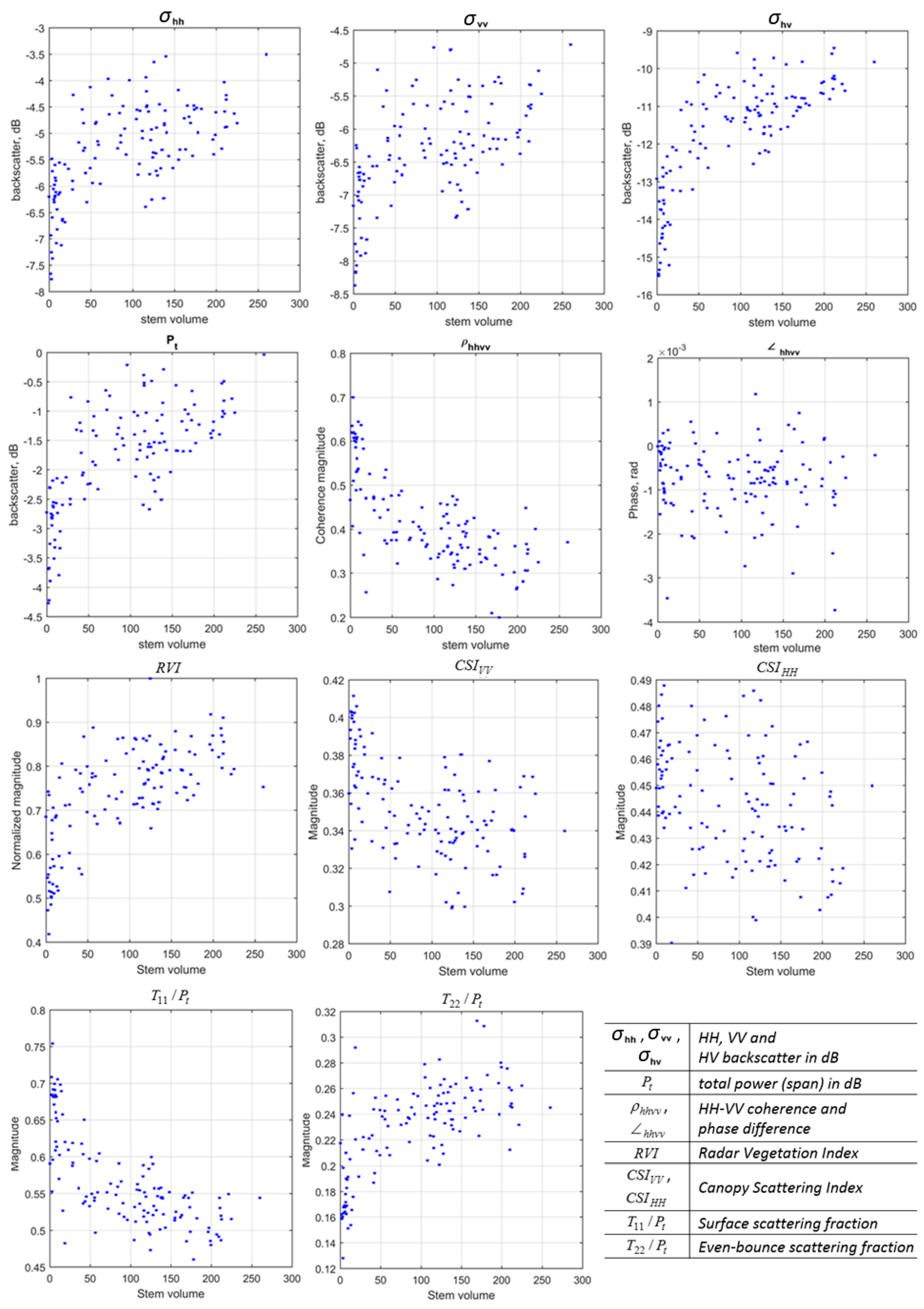
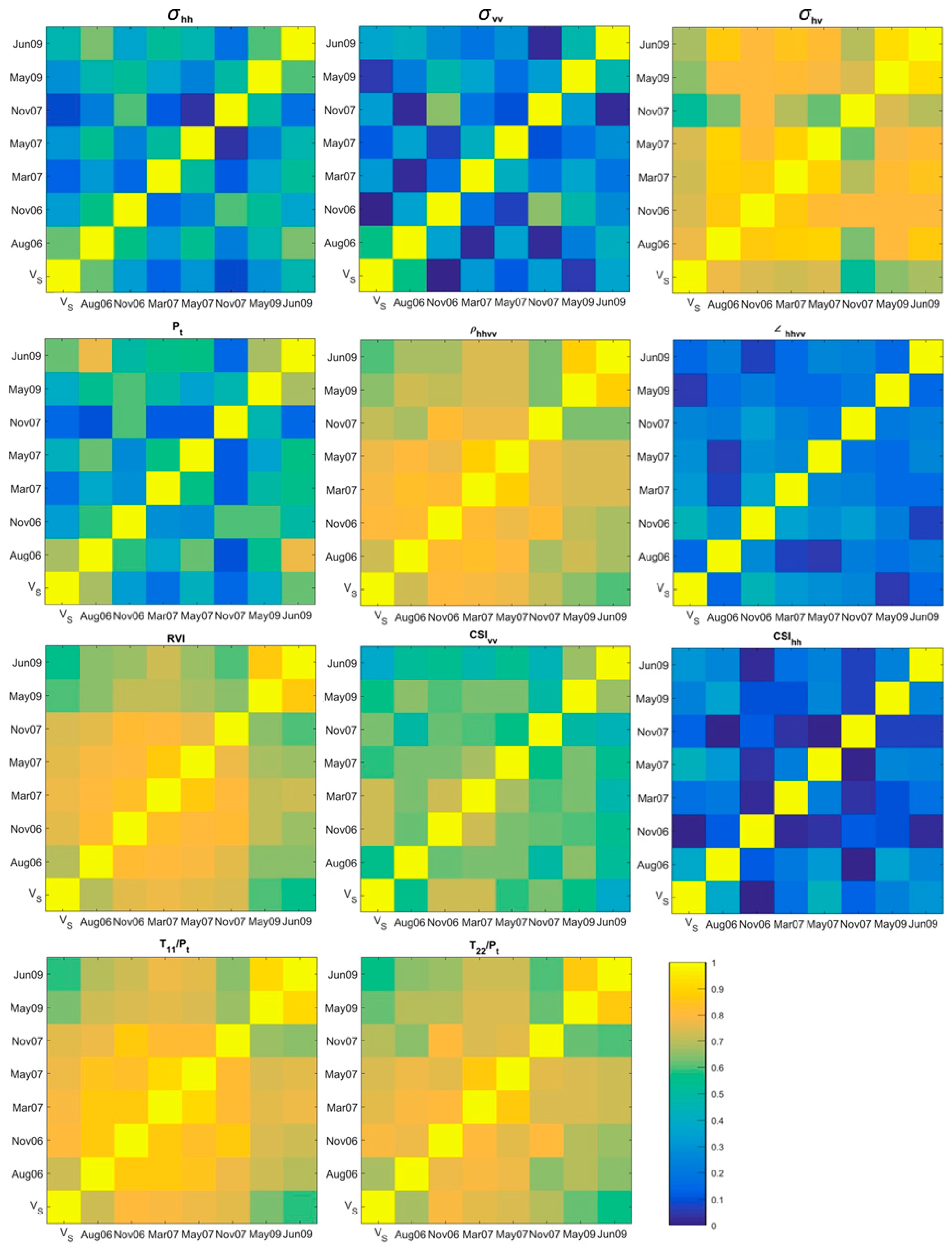
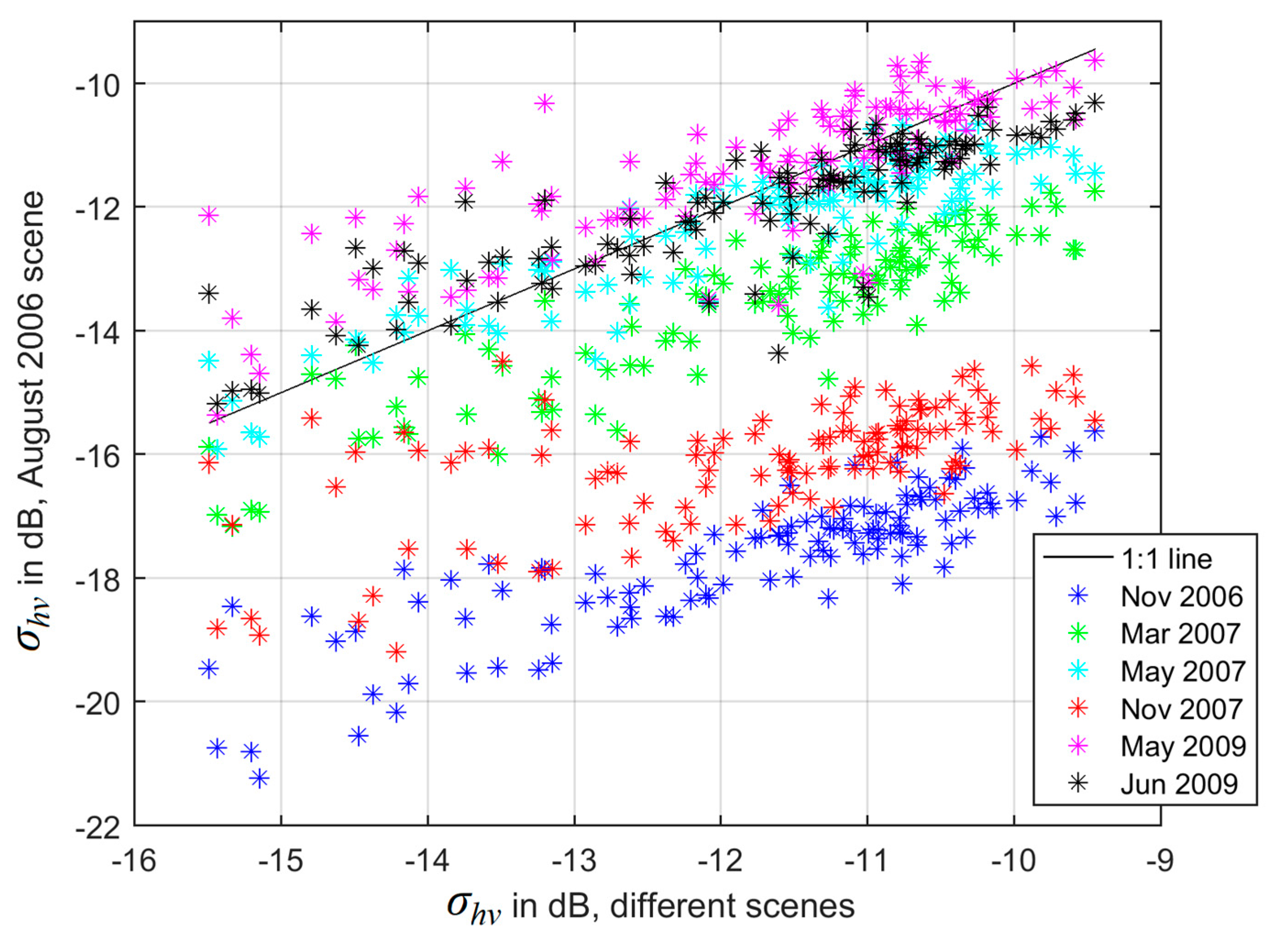
4.1. Temporal Dependence of PolSAR Parameters and Relation to Stem Volume
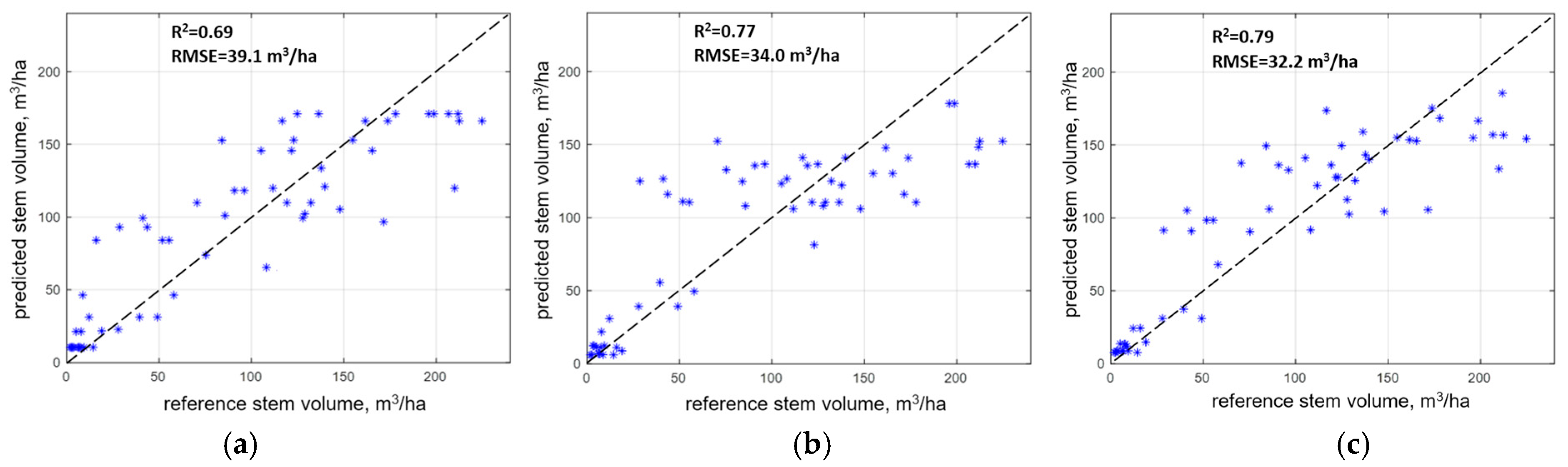
4.2. Forest Stem Volume Estimation
5. Discussion
5.1. Combining Polarimetric Coherence and Cross-Polarization Backscatter
5.2. Multitemporal Aggregation and Forest Growth
5.3. Relative Performance of Biomass Estimation Approach
6. Conclusions
Acknowledgments
Author Contributions
Conflicts of Interest
Abbreviations
| AGB | Aboveground Biomass |
| ALOS | Advanced Land Observing Satellite |
| DEM | Digital Elevation Model |
| ESA | European Space Agency |
| ENL | Equivalent Number of Looks |
| EO | Earth Observation |
| InSAR | Interferometric Synthetic Aperture Radar |
| JAXA | Japanese Aero eXploration Agency |
| JERS | Japanese Earth Remote Sensing |
| NFI | National Forest Inventory |
| NN | Nearest Neighbors |
| PALSAR | Phased Array L-band Add-on SAR |
| POA | Polarization Orientation Angle |
| PolSAR | Polarimetric Synthetic Aperture Radar |
| RMSE | Root Mean Squared Error |
| RVoG | Random Volume over Ground |
| SAR | Synthetic Aperture Radar |
| SLC | Single Look Complex |
| WCM | Water Cloud Model |
References
- FAO. Global Forest Resources Assessment 2005: Progress Towards Sustainable Forest Management; FAO: Roma, Italy, 2006. [Google Scholar]
- Saatchi, S.; Ulander, L.; Williams, M.; Quegan, S.; LeToan, T.; Shugart, H. Forest biomass and the science of inventory from space. Nat. Clim. Chang. 2012, 2, 826–827. [Google Scholar] [CrossRef]
- GCOS. Status of the Global Observing System for Climate; World Meteorological Organization: Geneva, Switzerland, 2015; Available online: https://library.wmo.int/pmb_ged/gcos_195_en.pdf (accessed on 1 July 2017).
- Le Toan, T.; Quegan, S.; Woodward, I.; Lomas, M.; Delbart, N.; Picard, G. Relating radar remote sensing of biomass to modelling of forest carbon budgets. Clim. Chang. 2004, 67, 379–402. [Google Scholar] [CrossRef]
- Stelmaszczuk-Górska, M.A.; Thiel, C.J.; Schmullius, C.C. Remote sensing for aboveground biomass estimation in boreal forests. In Earth Observation for Land and Emergency Monitoring; Balzter, H., Ed.; Wiley: New York, NY, USA, 2017; 336 p. [Google Scholar]
- Sinha, S.; Jeganathan, C.; Sharma, L.K.; Nathawat, M.S. A review of radar remote sensing for biomass estimation. Int. J. Environ. Sci. Technol. 2015, 12, 1779–1792. [Google Scholar] [CrossRef]
- Villard, L.; Le Toan, T.; TangMinh, D.H.; Mermoz, S.; Bouvet, A. Forest biomass from radar remote sensing. In Land Surface Remote Sensing in Agriculture and Forest; ISTE Press-Elsevier: London, UK, 2016; pp. 363–425. [Google Scholar]
- Ouchi, K. Recent trend and advance of synthetic aperture radar with selected topics. Remote Sens. 2013, 5, 716–807. [Google Scholar] [CrossRef]
- Imhoff, M.L. Radar backscatter and biomass saturation: Ramifications for global biomass inventory. IEEE Trans. Geosci. Remote Sens. 1995, 33, 511–518. [Google Scholar] [CrossRef]
- Le Toan, T.; Beaudoin, A.; Riom, J.; Guyon, D. Relating forest biomass to SAR data. IEEE Trans. Geosci. Remote Sens. 1992, 30, 403–411. [Google Scholar] [CrossRef]
- Rauste, Y. Multi-temporal JERS SAR data in boreal forest biomass mapping. Remote Sens. Environ. 2005, 97, 263–275. [Google Scholar] [CrossRef]
- Cloude, S. Polarisation: Applications in Remote Sensing; Oxford University Press: Oxford, UK, 2009. [Google Scholar]
- Riegger, S.; Werner, W. Wide-band polarimetric signatures as a basis for target classification. Proc. IEEE 1989, 77, 649–658. [Google Scholar] [CrossRef]
- Freeman, A.; Durden, S.L. A three-component scattering model for polarimetric SAR data. IEEE Trans. Geosci. Remote Sens. 1997, 36, 963–973. [Google Scholar] [CrossRef]
- Antropov, O.; Rauste, Y.; Häme, T. Volume scattering modeling in PolSAR decompositions: Study of ALOS PALSAR data over boreal forest. IEEE Trans. Geosci. Remote Sens. 2011, 49, 3838–3848. [Google Scholar] [CrossRef]
- Xie, Q.; Ballester-Berman, J.D.; Lopez Sanchez, J.M.; Zhu, J.; Wang, C. On the use of generalized volume scattering models for the improvement of general polarimetric model-based decomposition. Remote Sens. 2017, 9, 117. [Google Scholar] [CrossRef]
- Green, R.M. Relationships between polarimetric SAR backscattering and forest canopy and sub-canopy biophysical properties. Int. J. Remote Sens. 1998, 19, 2395–2412. [Google Scholar] [CrossRef]
- Watanabe, M.; Shimada, M.; Rosenqvist, A.; Tadono, T.; Matsuoka, M.; Romshoo, S.A.; Ohta, K.; Furuta, R.; Nakamura, K.; Moriyama, T. Forest structure dependency of the relation between L-band and biophysical parameters. IEEE Trans. Geosci. Remote Sens. 2006, 44, 3154–3165. [Google Scholar] [CrossRef]
- Moghaddam, M. Analysis of scattering mechanisms in SAR imagery over boreal forest: Results from BOREAS’93. IEEE Trans. Geosci. Remote Sens. 1995, 33, 1290–1296. [Google Scholar] [CrossRef]
- Saatchi, S.S.; Moghaddam, M. Estimation of crown and stem water content and biomass of boreal forest using polarimetric SAR imagery. IEEE Trans. Geosci. Remote Sens. 2000, 38, 697–709. [Google Scholar] [CrossRef]
- Urbazaev, M.; Thiel, C.; Mathieu, R.; Naidoo, L.; Levick, S.R.; Smit, I.P.J.; Asner, G.P.; Schmullius, C. Assessment of the mapping of fractional woody cover in southern African savannas using multi-temporal and polarimetric ALOS PALSAR L-band images. Remote Sens. Environ. 2015, 166, 138–153. [Google Scholar] [CrossRef]
- Maghsoudi, Y.; Collins, M.; Leckie, D.G. Polarimetric classification of boreal forest using nonparametric feature selection and multiple classifiers. Int. J. Appl. Earth Obs. Geoinf. 2012, 19, 139–150. [Google Scholar] [CrossRef]
- Antropov, O.; Rauste, Y.; Astola, H.; Praks, J.; Häme, T.; Hallikainen, M.T. Land cover and soil type mapping from spaceborne PolSAR data at L-band with probabilistic neural network. IEEE Trans. Geosci. Remote Sens. 2014, 52, 5256–5270. [Google Scholar] [CrossRef]
- Antropov, O.; Rauste, Y.; Lönnqvist, A.; Häme, T. PolSAR mosaic normalization for improved land-cover mapping. IEEE Geosci. Remote Sens. Lett. 2012, 9, 1074–1078. [Google Scholar] [CrossRef]
- Karam, M.A.; Amar, F.; Fung, A.K.; Mougin, E.; Lopes, A.; Le Vine, D.M.; Beaudoin, A. A microwave polarimetric scattering model for forest canopies based on vector radiative transfer theory. Remote Sens. Environ. 1995, 53, 16–30. [Google Scholar] [CrossRef]
- Balzter, H.; Baker, J.R.; Hallikainen, M.; Tomppo, E. Retrieval of timber volume and snow water equivalent over a Finnish boreal forest from airborne polarimetric synthetic aperture radar. Int. J. Remote Sens. 2002, 23, 3185–3208. [Google Scholar] [CrossRef]
- Proisy, C.; Mougin, E.; Fromard, F.; Karam, M.A. Interpretation of polarimetric radar signatures of mangrove forests. Remote Sens. Environ. 2000, 71, 56–66. [Google Scholar] [CrossRef]
- Hoekman, D.H.; Quinones, M.J. Land cover type and biomass classification using AirSAR data for evaluation of monitoring scenarios in the Colombian Amazon. IEEE Trans. Geosci. Remote Sens. 2000, 38, 685–696. [Google Scholar] [CrossRef]
- Garestier, F.; Dubois-Fernandez, P.C.; Guyon, D.; Le Toan, T. Forest biophysical parameter estimation using L- and P-band polarimetric SAR data. IEEE Trans. Geosci. Remote Sens. 2009, 47, 3379–3388. [Google Scholar] [CrossRef]
- Gonçalves, F.G.; Santos, J.R.; Treuhaft, R.N. Stem volume of tropical forests from polarimetric radar. Int. J. Remote Sens. 2011, 32, 503–522. [Google Scholar] [CrossRef]
- Praks, J.; Alasalmi, H.; Hallikainen, M. Polarimetric properties of boreal forest in L- and C-band SAR images. In Proceedings of the IEEE 2001 International Geoscience and Remote Sensing Symposium, Sydney, Australia, 9–13 July 2001; pp. 3050–3052. [Google Scholar]
- Rauste, Y.; Hame, T.; Pullianen, J.; Heiska, K.; Hallikainen, M. Radar-based forest biomass estimation. Int. J. Remote Sens. 1994, 15, 2797–2808. [Google Scholar] [CrossRef]
- Rauste, Y.; Lönnqvist, A.; Ahola, H. Mapping boreal forest biomass with imagery from polarimetric and semi-polarimetric SAR sensors. Ambiencia 2008, 4, 171–180. [Google Scholar]
- Neumann, M.; Saatchi, S. Polarimetric backscatter optimization for biophysical parameter estimation. IEEE Geosci. Remote Sens. Lett. 2014, 11, 254–258. [Google Scholar] [CrossRef]
- Rosenqvist, Å.; Shimada, M.; Ito, N.; Watanabe, M. ALOS PALSAR: A pathfinder mission for global-scale monitoring of the environment. IEEE Trans. Geosci. Remote Sens. 2007, 45, 3307–3316. [Google Scholar] [CrossRef]
- Pulliainen, J.T.; Kurvonen, L.; Hallikainen, M.T. Multitemporal behavior of L- and C-band SAR observations of boreal forests. IEEE Trans. Geosci. Remote Sens. 1999, 37, 927–937. [Google Scholar] [CrossRef]
- Kurvonen, L.; Pulliainen, J.; Hallikainen, M. Retrieval of biomass in boreal forests from multitemporal ERS-1 and JERS-1 SAR images. IEEE Trans. Geosci. Remote Sens. 1999, 37, 198–205. [Google Scholar] [CrossRef]
- Santoro, M.; Eriksson, L.E.B.; Fransson, J.E.S. Reviewing ALOS PALSAR backscatter observations for stem volume retrieval in Swedish forest. Remote Sens. 2015, 7, 4290–4317. [Google Scholar] [CrossRef]
- Antropov, O.; Rauste, Y.; Ahola, H.; Häme, T. Stand-level stem-volume of boreal forests from spaceborne SAR imagery at L-band. IEEE J. Sel. Top. Appl. Earth Obs. Remote Sens. 2013, 10, 142–149. [Google Scholar] [CrossRef]
- Peregon, A.; Yamagata, Y. The use of ALOS/PALSAR backscatter to estimate above-ground forest biomass: A case study in Western Siberia. Remote Sens. Environ. 2013, 137, 139–146. [Google Scholar] [CrossRef]
- Cartus, O.; Santoro, M.; Kellndorfer, J. Mapping forest aboveground biomass in the Northeastern United States with ALOS PALSAR dual polarization L-band. Remote Sens. Environ. 2012, 124, 466–478. [Google Scholar] [CrossRef]
- Chowdhury, T.A.; Thiel, C.; Schmullius, C. Growing stock volume estimation from L-band ALOS PALSAR polarimetric coherence in Siberian forest. Remote Sens. Environ. 2014, 155, 129–144. [Google Scholar] [CrossRef]
- Chowdhury, T.A.; Thiel, C.; Schmullius, C.; Stelmaszczuk-Górska, M. Polarimetric parameters for growing stock volume estimation using ALOS PALSAR L-Band data over Siberian forests. Remote Sens. 2013, 5, 5725–5756. [Google Scholar] [CrossRef]
- Thiel, C.; Schmullius, C. The potential of ALOS PALSAR backscatter and InSAR coherence for forest growing stock volume estimation in Central Siberia. Remote Sens. Environ. 2016, 173, 258–273. [Google Scholar] [CrossRef]
- Cloude, S.R.; Pottier, E. A review of target decomposition theorems in radar polarimetry. IEEE Trans. Geosci. Remote Sens. 1996, 34, 498–518. [Google Scholar] [CrossRef]
- Richards, J.A. Remote Sensing with Imaging Radar; Springer: Berlin/Heidelberg, Germany, 2009. [Google Scholar]
- Praks, J.; Koeniguer, E.; Hallikainen, M.T. Alternatives to target entropy and alpha angle in SAR polarimetry. IEEE Trans. Geoci. Remote Sens. 2009, 47, 2262–2274. [Google Scholar] [CrossRef]
- Kim, Y.; Van Zyl, J. Comparison of forest parameter estimation techniques using SAR data. In Proceedings of the IEEE 2001 International Geoscience and Remote Sensing Symposium, Sydney, Australia, 9–13 July 2001; pp. 1395–1397. [Google Scholar]
- Pope, K.O.; Rey-Benayas, J.M.; Paris, J.F. Radar remote sensing of forest and wetland ecosystems in the Central American tropics. Remote Sens. Environ. 1994, 48, 205–219. [Google Scholar] [CrossRef]
- Shimada, M.; Isoguchi, O.; Tadono, T.; Isono, K. PALSAR radiometric and geometric calibration. IEEE Trans. Geosci. Remote Sens. 2009, 47, 3915–3932. [Google Scholar] [CrossRef]
- Rauste, Y.; Lönnqvist, A.; Molinier, M.; Henry, J.-B.; Häme, T. Ortho-rectification and terrain correction of polarimetric SAR data applied in the ALOS/Palsar context. In Proceedings of the IEEE International Geoscience and Remote Sensing Symposium, Barcelona, Spain, 23–27 July 2007; pp. 1618–1621. [Google Scholar]
- Small, D. Flattening gamma: Radiometric terrain correction for SAR imagery. IEEE Trans. Geosci. Remote Sens. 2011, 49, 3081–3093. [Google Scholar] [CrossRef]
- Freeman, A. Calibration of linearly polarized polarimetric SAR data subject to Faraday rotation. IEEE Trans. Geosci. Remote Sens. 2004, 42, 1617–1624. [Google Scholar] [CrossRef]
- Sandberg, G.; Eriksson, L.E.B.; Ulander, L.M.H. Measurements of Faraday rotation using polarimetric PALSAR images. IEEE Geosci. Remote Sens. Lett. 2009, 6, 142–146. [Google Scholar] [CrossRef]
- Freeman, A.; Saatchi, S.S. On the detection of Faraday rotation in linearly polarized L-band SAR backscatter signatures. IEEE Trans. Geosci. Remote Sens. 2004, 42, 1607–1616. [Google Scholar] [CrossRef]
- Lee, J.S.; Ainsworth, T.L. The effect of orientation angle compensation on coherency matrix and polarimetric target decomposition. IEEE Trans. Geosci. Remote Sens. 2011, 49, 53–64. [Google Scholar] [CrossRef]
- Wagner, W.; Luckman, A.; Vietmeier, J.; Tansey, K.; Balzter, H.; Schmullius, C.; Davidson, M.; Gaveau, D.; Gluck, M.; Le Toan, T.; et al. Large-scale mapping of boreal forest in SIBERIA using ERS tandem coherence and JERS backscatter data. Remote Sens. Environ. 2003, 85, 125–144. [Google Scholar] [CrossRef]
- Packalen, P.; Maltamo, M. The k-MSN method in the prediction of species specific stand attributes using airborne laser scanning and aerial photographs. Remote Sens. Environ. 2007, 109, 328–341. [Google Scholar] [CrossRef]
- Maltamo, M.; Packalen, P.; Suvanto, A.; Korhonen, K.T.; Mehtätalo, L.; Hyvönen, P. Combining ALS and NFI training data for forest management planning: A case study in Kuortane, Western Finland. Eur. J. For. Res. 2009, 128, 305–317. [Google Scholar] [CrossRef]
- Tomppo, E. The Finnish multi-source National Forest Inventory—Small area estimation and map production. In Forest Inventory: Methodology and Applications. Managing Forest Ecosystems; Kangas, A., Maltamo, M., Eds.; Springer: Dordrecht, The Nederlands, 2006; pp. 195–224. [Google Scholar]
- Tomppo, E.; Halme, M. Using coarse scale forest variables as ancillary information and weighting of variables in k-NN estimation: A genetic algorithm approach. Remote Sens. Environ. 2004, 92, 1–20. [Google Scholar] [CrossRef]
- Finley, A.O.; McRoberts, R.E.; Ek, A.R. Applying an efficient k nearest neighbor search to forest attribute imputation. For. Sci. 2006, 52, 130–135. [Google Scholar]
- Quegan, S.; Le Toan, T.; Yu, J.J.; Ribbes, F.; Floury, N. Multitemporal ERS SAR analysis applied to forest mapping. IEEE Trans. Geosci. Remote Sens. 2000, 38, 741–753. [Google Scholar] [CrossRef]
- Quegan, S.; Yu, J.J. Filtering of multichannel SAR images. IEEE Trans. Geosci. Remote Sens. 2001, 39, 2373–2379. [Google Scholar] [CrossRef]
- Dobson, M.C.; Ulaby, F.T.; Le Toan, T.; Beaudoin, A.; Kasischke, E.S.; Christensen, N. Dependence of radar backscatter on coniferous forest biomass. IEEE Trans. Geosci. Remote Sens. 1992, 30, 412–415. [Google Scholar] [CrossRef]
- Ranson, K.J.; Sun, G. Mapping biomass of a northern forest using multifrequency SAR data. IEEE Trans. Geosci. Remote Sens. 1994, 32, 388–396. [Google Scholar] [CrossRef]
- Thiel, C.J.; Thiel, C.; Schmullius, C.C. Operational large-area forest monitoring in Siberia using ALOS PALSAR summer intensities and winter coherence. IEEE Trans. Geosci. Remote Sens. 2009, 47, 3993–4000. [Google Scholar] [CrossRef]
- Baghdadi, N.; Le Maire, G.; Bailly, J.S.; Osé, K.; Nouvellon, Y.; Zribi, M.; Lemos, C.; Hakamada, R. Evaluation of ALOS/PALSAR L-band data for the estimation of Eucalyptus plantations aboveground biomass in Brazil. IEEE J. Sel. Top. Appl. Earth Obs. Remote Sens. 2015, 8, 3802–3811. [Google Scholar] [CrossRef]
- Finnish Forest Research Institute. Finnish Statistical Yearbook of Forestry, 2012; Finnish Forest Research Institute: Vantaa, Finland, 2012; p. 71. [Google Scholar]
- Oliver, C.; Quegan, S. Understanding Synthetic Aperture Radar Images; SciTech Publishing: Raleigh, NC, USA, 2004. [Google Scholar]
- Lee, J.-S.; Grunes, M.R.; Schuler, D.L.; Pottier, E.; Ferro-Famil, L. Scattering-model-based speckle filtering of polarimetric SAR data. IEEE Trans. Geosci. Remote Sens. 2006, 44, 176–187. [Google Scholar]
- Sandberg, G.; Ulander, L.M.H.; Fransson, J.E.S.; Holmgres, J.; Le Toan, T. L- and P-band backscatter intensity for biomass retrieval in hemiboreal forest. Remote Sens. Environ. 2011, 115, 2874–2886. [Google Scholar] [CrossRef]
- Askne, J.; Santoro, M.; Smith, G.; Fransson, J.E.S. Multitemporal repeat-pass SAR interferometry of boreal forests. IEEE Trans. Geosci. Remote Sens. 2003, 41, 1540–1550. [Google Scholar] [CrossRef]
- Olesk, A.; Praks, J.; Antropov, O.; Zalite, K.; Arumäe, T.; Voormansik, K. Interferometric SAR Coherence Models for Characterization of Hemiboreal Forests Using TanDEM-X Data. Remote Sens. 2016, 8, 700. [Google Scholar] [CrossRef]
- Englhart, S.; Keuck, V.; Siegert, F. Modeling aboveground biomass in tropical forests using multi-frequency SAR data—A comparison of methods. IEEE J. Sel. Top. Appl. Earth Obs. Remote Sens. 2012, 5, 298–306. [Google Scholar] [CrossRef]
- Hyyppä, J.; Hyyppä, H.; Inkinen, M.; Engdahl, M.; Linko, S.; Zhu, Y.-H. Accuracy comparison of various remote sensing data sources in the retrieval of forest stand attributes. Forest Ecol. Manag. 2000, 128, 109–120. [Google Scholar] [CrossRef]
- Hame, T.; Rauste, Y.; Antropov, O.; Ahola, H.A.; Kilpi, J. Improved mapping of tropical forests with optical and SAR imagery, Part II: Above ground biomass estimation. IEEE J. Sel. Top. Appl. Earth Obs. Remote Sens. 2013, 6, 92–101. [Google Scholar] [CrossRef]


| Acquisition Date | Temperature Mean (Min; Max), °C | Precipitation, mm |
|---|---|---|
| 11 August 2006 | 18 (11; 26) | 0.0 |
| 11 November 2006 | −5 (−10; 0) | 0.2 |
| 29 March 2007 | 6 (−1; 14) | 0.0 |
| 5 May 2007 | 2 (−5; 10) | 0.9 |
| 14 November 2007 | −6 (−3; −9) | 0.0 |
| 5 May 2009 | 8 (4; 11) | 0.5 |
| 6 June 2009 | 6 (2; 9) | 0.3 |
| PolSAR Parameter | Scene | RMSE, m3 ha−1 | RMSE, % | r | R2 | Notes |
|---|---|---|---|---|---|---|
| 11 August 2006 | 41.0 | 43.2 | 0.81 | 0.66 | ||
| 11 November 2006 | 40.8 | 42.9 | 0.81 | 0.66 | ||
| 29 March 2007 | 44.6 | 46.9 | 0.77 | 0.59 | ||
| 14 May 2007 | 43.2 | 45.5 | 0.79 | 0.62 | ||
| 14 November 2007 | 56.4 | 59.1 | 0.59 | 0.35 | ||
| 19 May 2009 | 52.1 | 54.8 | 0.66 | 0.44 | ||
| 5 June 2009 | 49.7 | 52.3 | 0.70 | 0.49 | ||
| multitemp | 39.1 | 41.2 | 0.83 | 0.69 | first 4 scenes combined | |
| 11 August 2006 | 44.9 | 47.3 | 0.75 | 0.56 | ||
| 11 November 2006 | 38.8 | 40.8 | 0.84 | 0.71 | ||
| 29 March 2007 | 39.8 | 41.9 | 0.82 | 0.67 | ||
| 14 May 2007 | 42.6 | 44.8 | 0.80 | 0.64 | ||
| 14 November 2007 | 48.1 | 50.6 | 0.72 | 0.52 | ||
| 19 May 2009 | 47.7 | 50.2 | 0.74 | 0.55 | ||
| 5 June 2009 | 51.6 | 54.3 | 0.68 | 0.46 | ||
| multitemp | 34.0 | 35.8 | 0.88 | 0.77 | first 5 scenes combined | |
| and | 11 August 2006 | 40.7 | 42.8 | 0.82 | 0.67 | |
| 11 November 2006 | 37.4 | 39.4 | 0.85 | 0.72 | ||
| 29 March 2007 | 39.2 | 41.3 | 0.83 | 0.69 | ||
| 14 May 2007 | 40.1 | 42.2 | 0.82 | 0.67 | ||
| 14 November 2007 | 45.9 | 48.3 | 0.75 | 0.56 | ||
| 19 May 2009 | 46.7 | 49.2 | 0.74 | 0.55 | ||
| 5 June 2009 | 49.2 | 51.8 | 0.70 | 0.49 | ||
| multitemp | 32.2 | 33.9 | 0.89 | 0.79 | two multitemporal composites combined |
© 2017 by the authors. Licensee MDPI, Basel, Switzerland. This article is an open access article distributed under the terms and conditions of the Creative Commons Attribution (CC BY) license (http://creativecommons.org/licenses/by/4.0/).
Share and Cite
Antropov, O.; Rauste, Y.; Häme, T.; Praks, J. Polarimetric ALOS PALSAR Time Series in Mapping Biomass of Boreal Forests. Remote Sens. 2017, 9, 999. https://doi.org/10.3390/rs9100999
Antropov O, Rauste Y, Häme T, Praks J. Polarimetric ALOS PALSAR Time Series in Mapping Biomass of Boreal Forests. Remote Sensing. 2017; 9(10):999. https://doi.org/10.3390/rs9100999
Chicago/Turabian StyleAntropov, Oleg, Yrjö Rauste, Tuomas Häme, and Jaan Praks. 2017. "Polarimetric ALOS PALSAR Time Series in Mapping Biomass of Boreal Forests" Remote Sensing 9, no. 10: 999. https://doi.org/10.3390/rs9100999
APA StyleAntropov, O., Rauste, Y., Häme, T., & Praks, J. (2017). Polarimetric ALOS PALSAR Time Series in Mapping Biomass of Boreal Forests. Remote Sensing, 9(10), 999. https://doi.org/10.3390/rs9100999