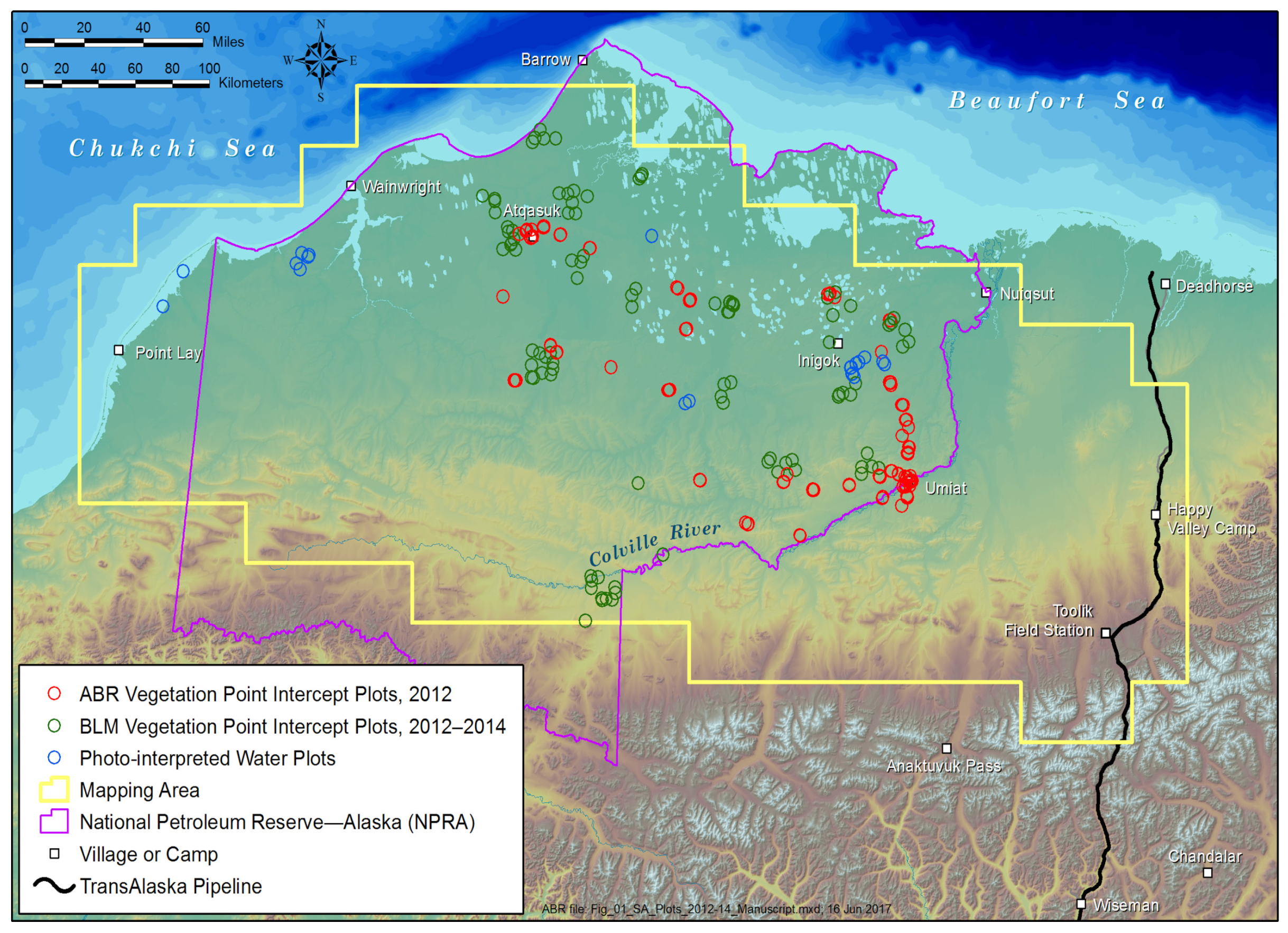
Figure 1.
Map of quantitative-cover mapping area showing the distribution of field plots, North Slope, Alaska. ABR, ABR, Inc.—Environmental Research & Services. BLM, Bureau of Land Management.
Figure 1.
Map of quantitative-cover mapping area showing the distribution of field plots, North Slope, Alaska. ABR, ABR, Inc.—Environmental Research & Services. BLM, Bureau of Land Management.
Figure 2.
Overview of random forest modeling process to predict cover of plant functional types (PFTs), litter and nonvegetated cover types, North Slope, Alaska.
Figure 2.
Overview of random forest modeling process to predict cover of plant functional types (PFTs), litter and nonvegetated cover types, North Slope, Alaska.
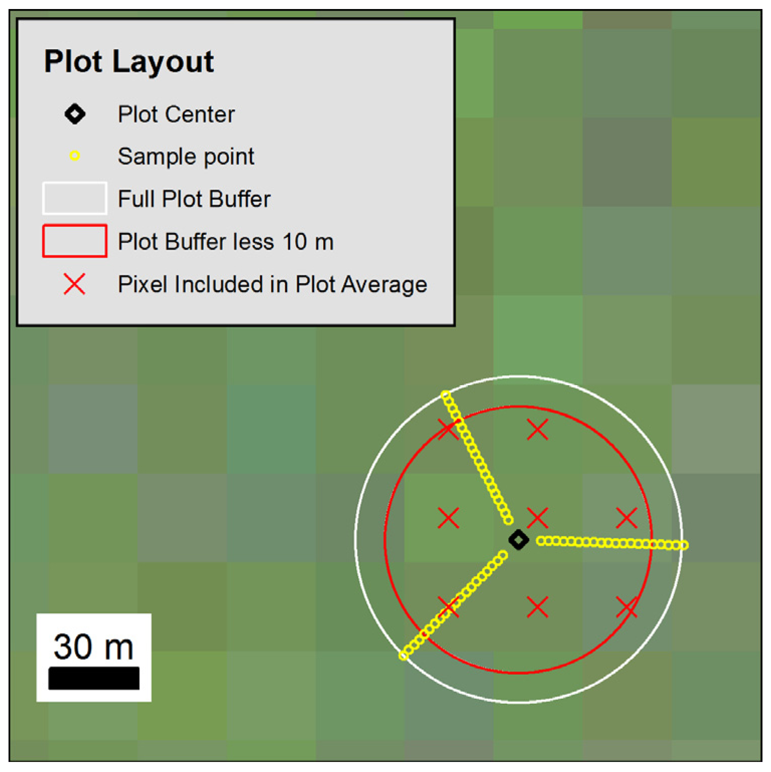
Figure 3.
Layout of point-intercept field plot, North Slope, Alaska. Lines sampled by ABR were 50 m in length; lines sampled by BLM were 25 m. Pixels from a midsummer Landsat composite (red/green/blue) are in the background. The pixels with centers inside a circular plot buffer less than 10 m were included in the calculation of average predictor values for each plot.
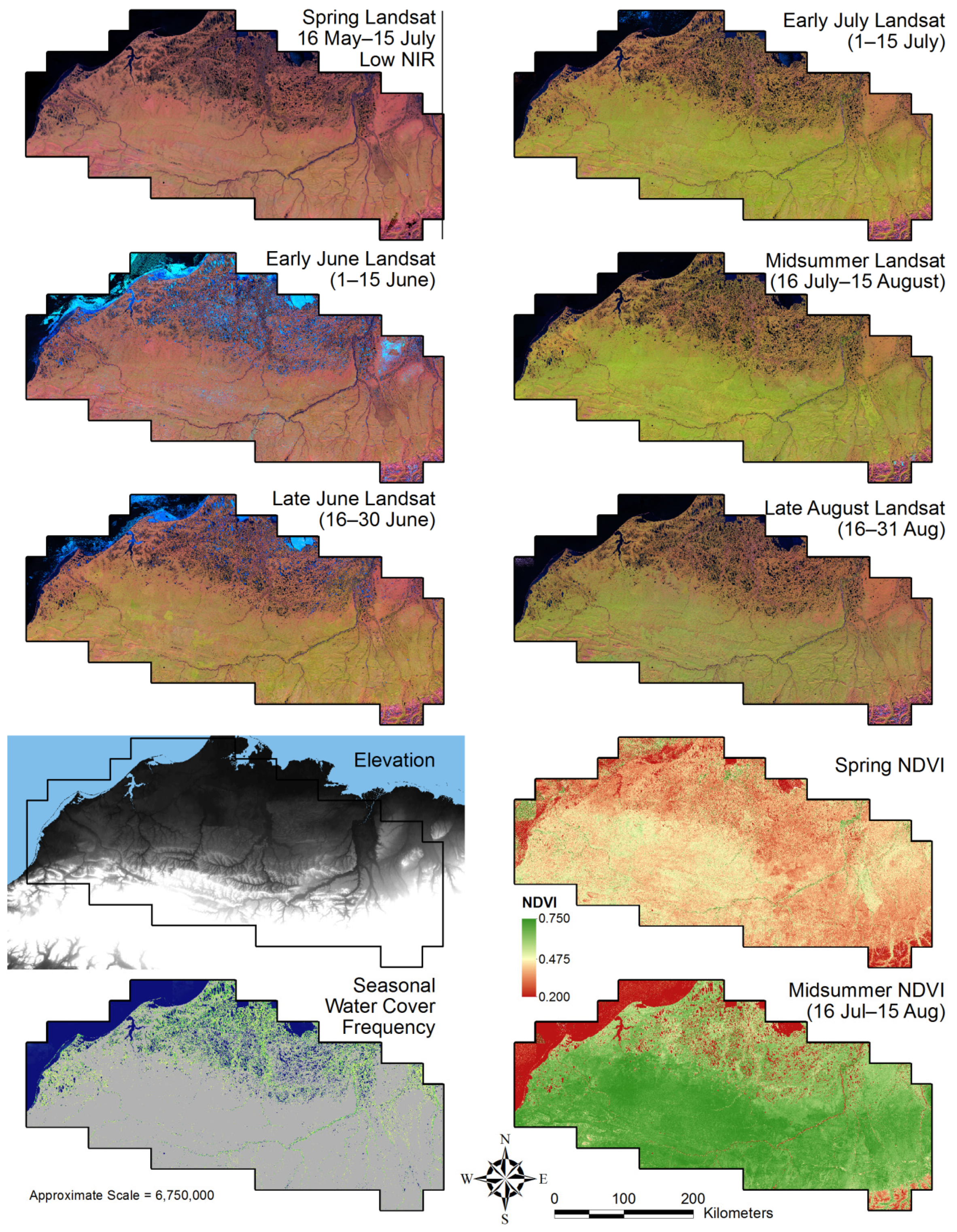
Figure 4.
Selected spectral and ancillary predictors used to predict cover of PFTs and other cover types, North Slope, Alaska.
Figure 4.
Selected spectral and ancillary predictors used to predict cover of PFTs and other cover types, North Slope, Alaska.
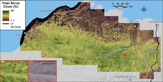
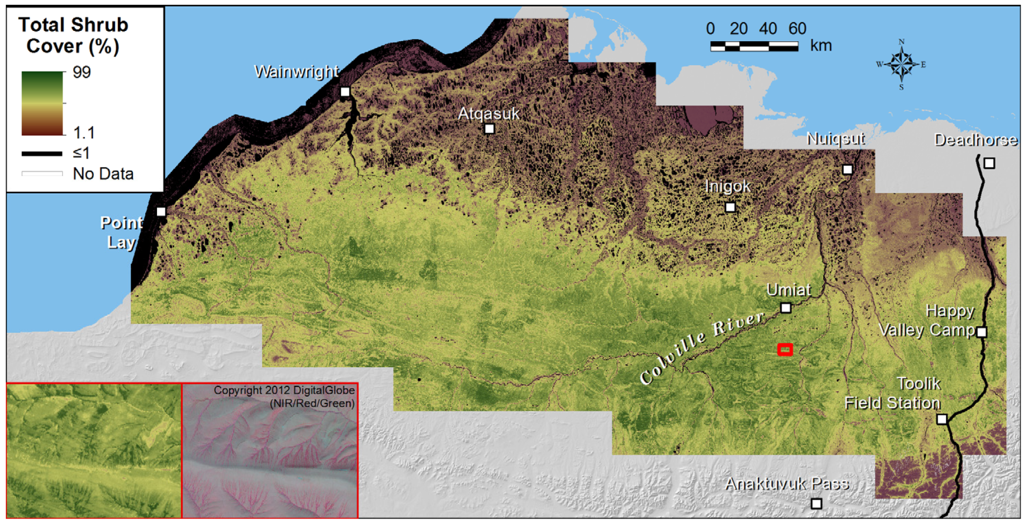
Figure 5.
Map of total shrub cover based on the random forest model with 78 predictors, North Slope, Alaska. The inset map displays landscape-scale patterns in total shrub distribution in the upland terrain south of Umiat.
Figure 5.
Map of total shrub cover based on the random forest model with 78 predictors, North Slope, Alaska. The inset map displays landscape-scale patterns in total shrub distribution in the upland terrain south of Umiat.
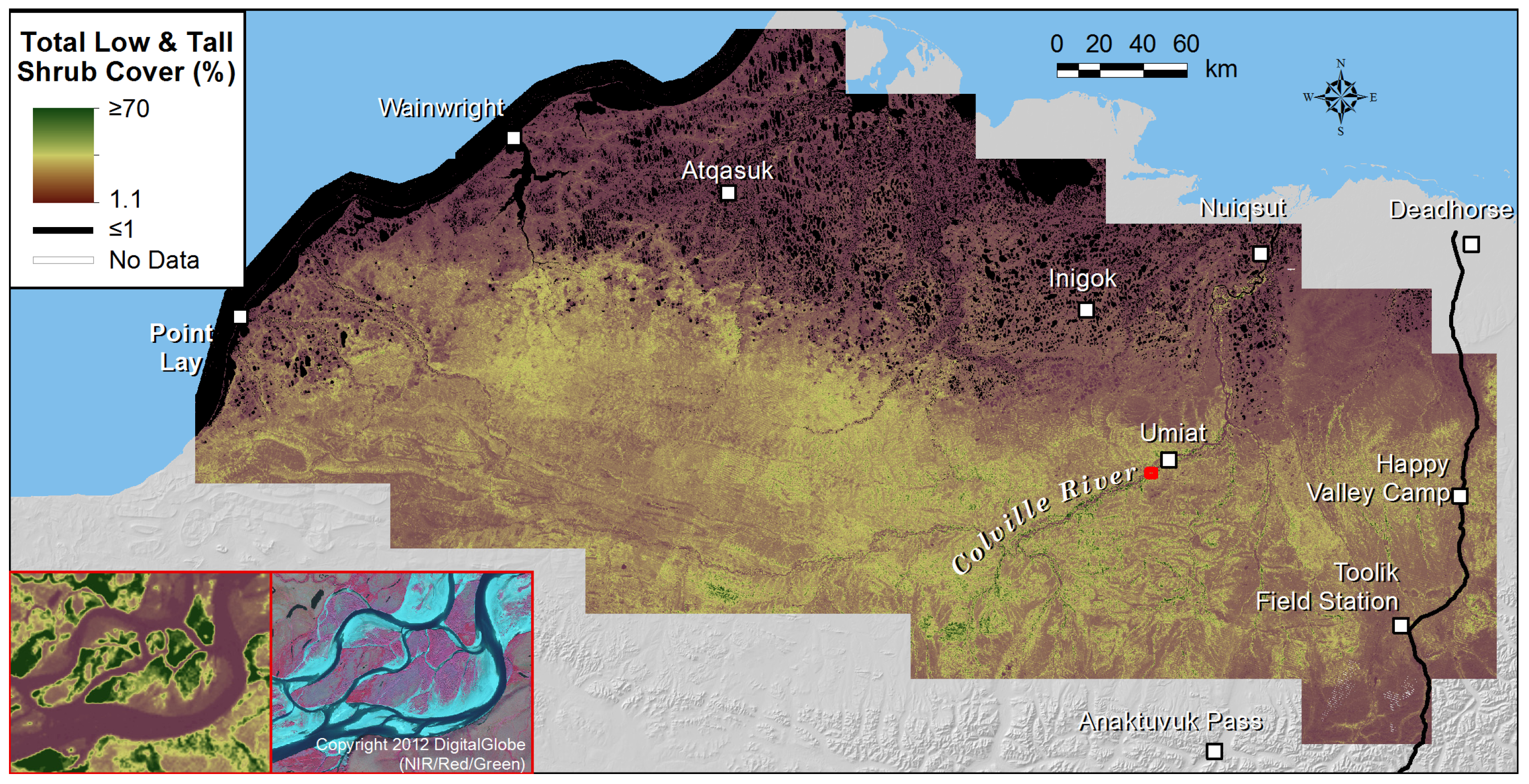
Figure 6.
Map of total low and tall deciduous shrub cover based on the random forest model with 78 predictors, North Slope, Alaska. The inset map displays examples of highly productive shrublands on the active floodplain of the Colville River.
Figure 6.
Map of total low and tall deciduous shrub cover based on the random forest model with 78 predictors, North Slope, Alaska. The inset map displays examples of highly productive shrublands on the active floodplain of the Colville River.
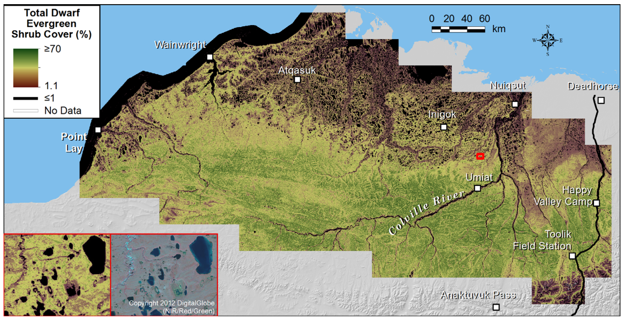
Figure 7.
Map of dwarf evergreen shrub cover based on the random forest model with 78 predictors, North Slope, Alaska. The inset map shows an example of dwarf evergreen shrub distribution on the eolian sand sheet region of the coastal plain, where this PFT is common, except in wet areas.
Figure 7.
Map of dwarf evergreen shrub cover based on the random forest model with 78 predictors, North Slope, Alaska. The inset map shows an example of dwarf evergreen shrub distribution on the eolian sand sheet region of the coastal plain, where this PFT is common, except in wet areas.
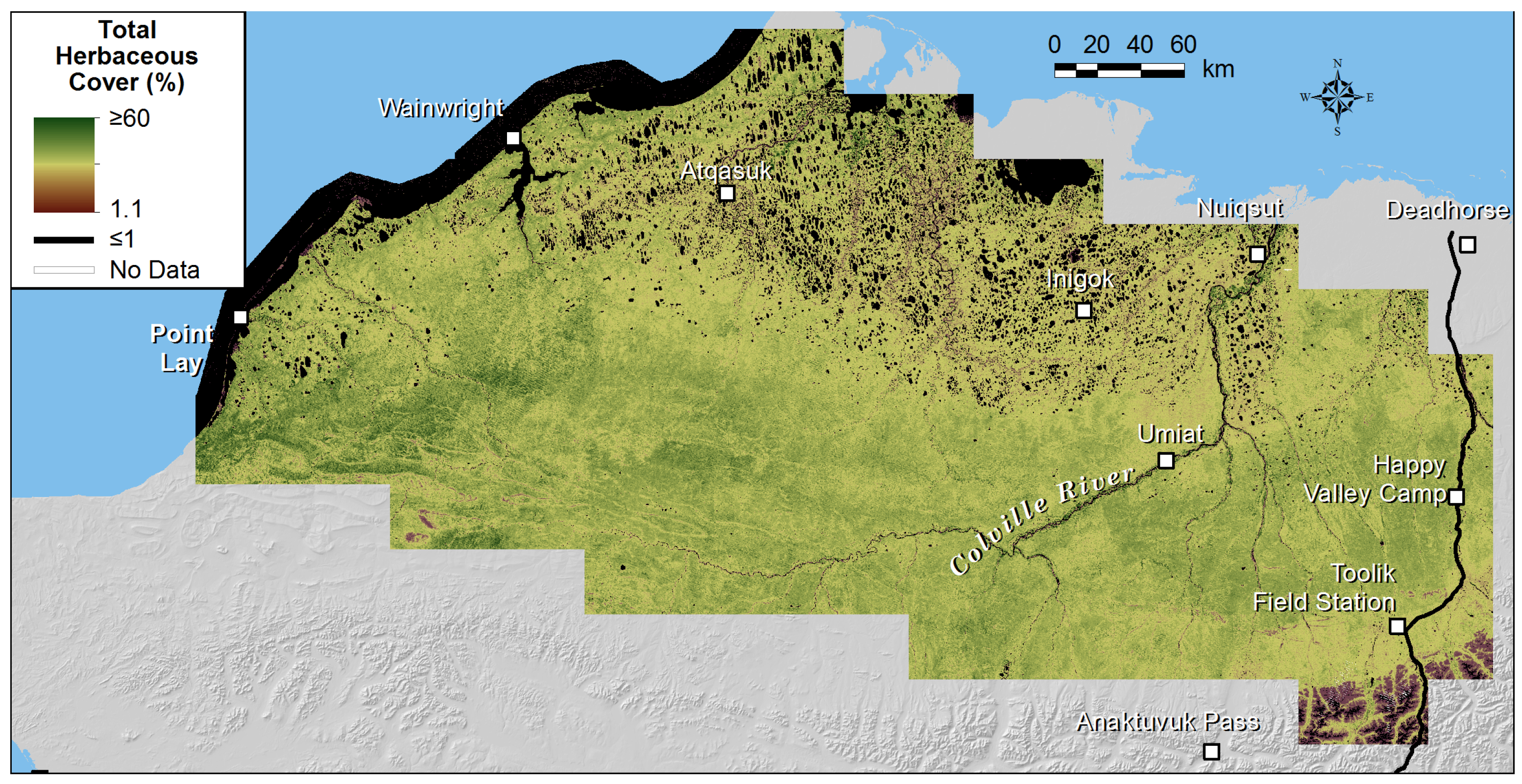
Figure 8.
Map of total herbaceous cover based on the random forest model with 78 predictors, North Slope, Alaska.
Figure 8.
Map of total herbaceous cover based on the random forest model with 78 predictors, North Slope, Alaska.
Figure 9.
Map of total nonvascular cover based on the random forest model with 78 predictors, North Slope, Alaska. The inset map portrays a typical lake-rich portion of the coastal plain; total nonvascular cover is generally high except in flooded lake margins and drained lake basins.
Figure 9.
Map of total nonvascular cover based on the random forest model with 78 predictors, North Slope, Alaska. The inset map portrays a typical lake-rich portion of the coastal plain; total nonvascular cover is generally high except in flooded lake margins and drained lake basins.
Figure 10.
Plot of unbiased variable importance determined by conditional random forest, by predictor rank for total cover of low and tall shrubs, North Slope, Alaska.
Figure 10.
Plot of unbiased variable importance determined by conditional random forest, by predictor rank for total cover of low and tall shrubs, North Slope, Alaska.
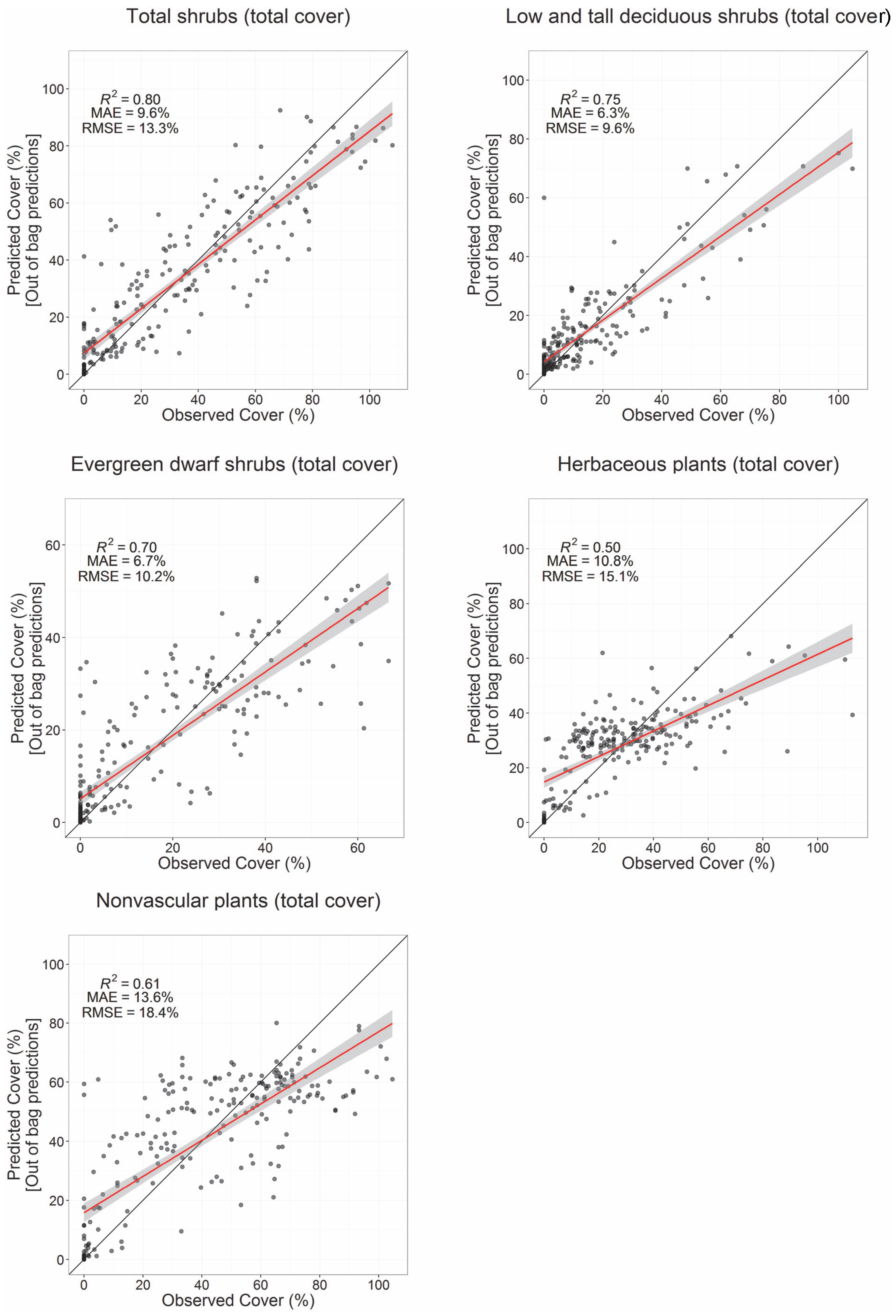
Figure 11.
Scatterplots comparing observed and predicted cover values from training and validation plots for selected PFTs using the full set of 78 predictors. Predicted values for training data are “out-of-bag” predictions. The red lines are linear fits with 95% confidence intervals (grey).
Figure 11.
Scatterplots comparing observed and predicted cover values from training and validation plots for selected PFTs using the full set of 78 predictors. Predicted values for training data are “out-of-bag” predictions. The red lines are linear fits with 95% confidence intervals (grey).
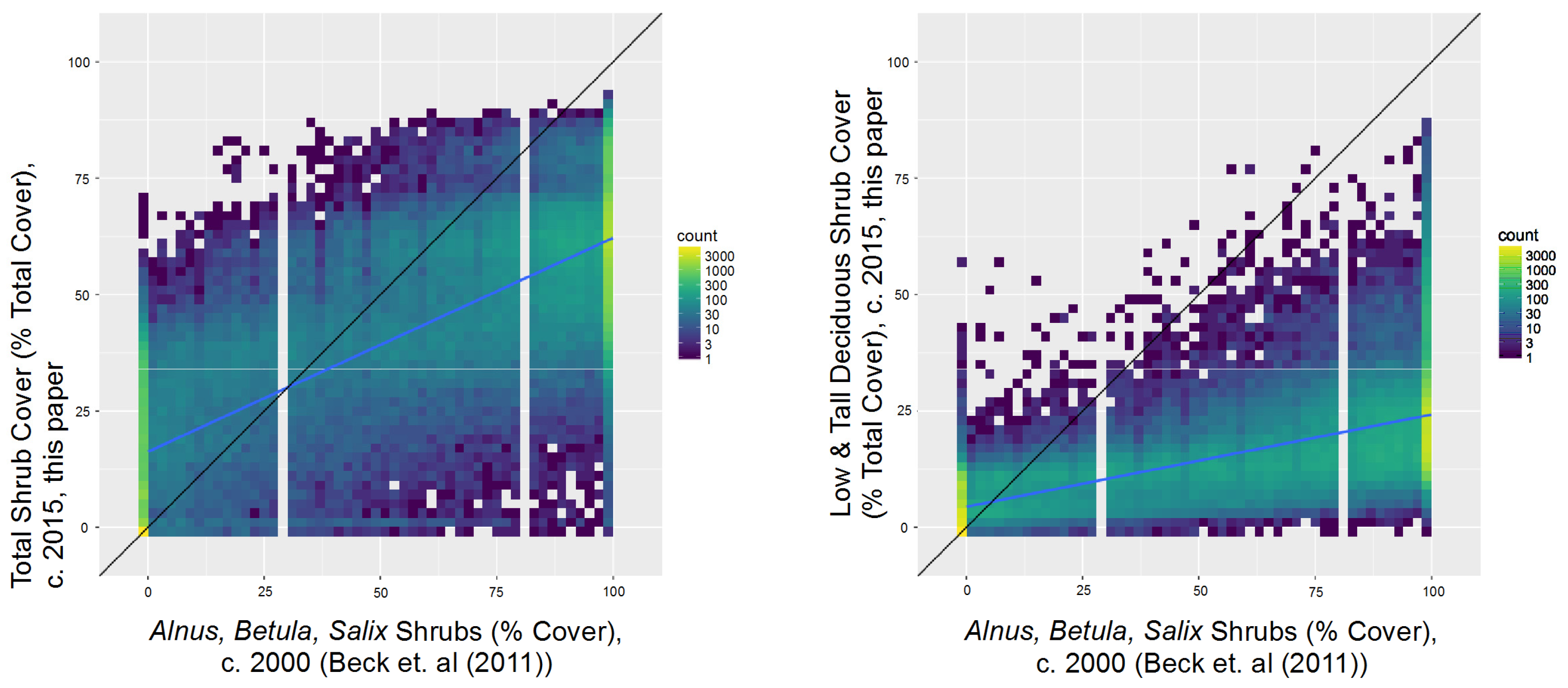
Figure 12.
Comparison of shrub cover from Beck et al. [
29] circa 2000 North Slope shrub map and the current work, North Slope, Alaska. The black line is 1:1 line, and the blue line is the linear best fit.
Figure 12.
Comparison of shrub cover from Beck et al. [
29] circa 2000 North Slope shrub map and the current work, North Slope, Alaska. The black line is 1:1 line, and the blue line is the linear best fit.
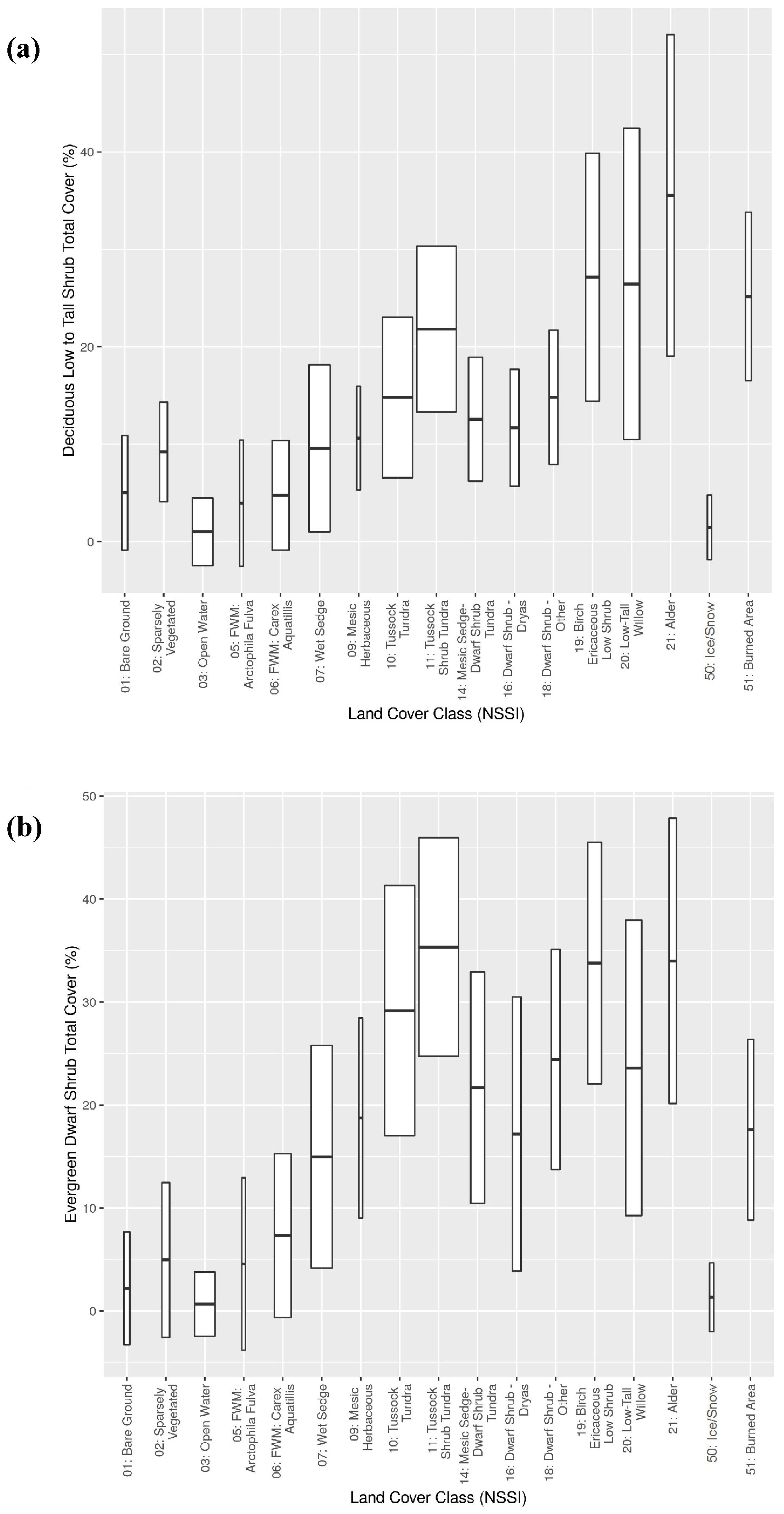
Figure 13.
Box and whisker plots of (
a) low and tall deciduous shrub cover and (
b) dwarf evergreen shrub cover, summarized by the North Slope Science Initiative (NSSI) Land Cover [
5] map class. The width of boxes is proportional to the square root of the area of each map class.
Figure 13.
Box and whisker plots of (
a) low and tall deciduous shrub cover and (
b) dwarf evergreen shrub cover, summarized by the North Slope Science Initiative (NSSI) Land Cover [
5] map class. The width of boxes is proportional to the square root of the area of each map class.
Table 1.
Tundra PFTs and other cover types used for cover modeling, North Slope, Alaska.
Table 1.
Tundra PFTs and other cover types used for cover modeling, North Slope, Alaska.
| PFT or Other Cover Type | Description | Cover Metric(s) Modeled |
|---|
| Tall Deciduous Shrubs | deciduous shrubs ≥1.5 m height; mainly Salix alaxensis, S. arbusculoides and Alnus fruticosa | Total cover |
| Low Deciduous Shrubs | deciduous shrubs 0.2–1.5 m height; e.g., Betula nana, Salix pulchra and S. glauca | Total cover |
| Dwarf Deciduous Shrubs | deciduous shrubs ≤0.2 m height; e.g., Salix rotundifolia, Arctous spp. and Vaccinium uliginosum. | Total cover |
| Dwarf Evergreen Shrubs | evergreen shrubs ≤0.2-m height; e.g., Dryas integrifolia, Cassiope tetragona, Vaccinium vitis-ideas and Ledum decumbens | Total cover |
| Sedges | herbaceous plants of Cyperaceae and Juncaceae; e.g., Carex and Eriophorum spp. | Total cover |
| Grasses | herbaceous plants of Poaceae; e.g., Arctagrostis, Arctophila, Deschampsia | Total cover |
| Forbs | non-graminoid herbaceous plants; e.g., legumes and composites | Total cover |
| Mosses | total of all mosses and liverworts | Total cover |
| Lichens | total of all ground lichens | Total cover |
| Total Herbaceous | total of sedges, grasses, and forbs | Total cover |
| Total Shrubs | total of all shrub PFTs | Total cover |
| Low & Tall Deciduous Shrubs | deciduous shrubs ≥0.2-m height | Total cover |
| Vascular Plants | total of all vascular PFTs | Total and top cover |
| Nonvascular Plants | total of all nonvascular PFTs including mosses, terricolous lichens, liverworts and algae | Total and top cover |
| Litter | dead plant matter | Top cover |
| Open Water | open water | Top cover |
| Bare Ground | bare soil or rock | Top cover |
Table 2.
Spectral and environmental predictors for random forest models of tundra PFTs and other cover types, North Slope, Alaska. SR is surface reflectance.
Table 2.
Spectral and environmental predictors for random forest models of tundra PFTs and other cover types, North Slope, Alaska. SR is surface reflectance.
| Predictor | Spectral Bands | Spectral Indices | n | Data Source or Reference |
|---|
| Spring snow-free SR: lowest NIR of four periods, 16 May–15 July 2010–2015 | R, G, B, NIR, SWIR1/2 | NDVI, NBR, NDMI, NDWI, NDSI, EVI2 | 12 | Landsat TM/ETM+/OLI |
| Early June 20th percentile NIR SR: 1–15 June 2010–2015 | R, G, B, NIR, SWIR1/2 | NDVI, NBR, NDMI, NDWI, NDSI, EVI2 | 12 | Landsat TM/ETM+/OLI |
| Late June median NIR SR: 16–30 June 2010–2015 | R, G, B, NIR, SWIR1/2 | NDVI, NBR, NDMI, NDWI, NDSI, EVI2 | 12 | Landsat TM/ETM+/OLI |
| Early July median NIR SR: 1–15 July 2010–2015 | R, G, B, NIR, SWIR1/2 | NDVI, NBR, NDMI, NDWI, NDSI, EVI2 | 12 | Landsat TM/ETM+/OLI |
| Midsummer median NIR SR: 16 July–15 August 2010–2015 | R, G, B, NIR, SWIR1/2 | NDVI, NBR, NDMI, NDWI, NDSI, EVI2 | 12 | Landsat TM/ETM+/OLI |
| Late August median NIR SR: 16–31 August 1999–2015 | R, G, B, NIR, SWIR1/2 | NDVI, NBR, NDMI, NDWI, NDSI, EVI2 | 12 | Landsat TM/ETM+/OLI |
| NDVI change, spring snow-free to midsummer | n/a | NDVI | 1 | Landsat TM/ETM+/OLI |
| Median snow-free date | n/a | n/a | 1 | [44] |
| Elevation | n/a | n/a | 1 | IFSAR1 DEM |
| Slope angle | n/a | n/a | 1 | IFSAR1 DEM |
| Summer Warmth Index | n/a | n/a | 1 | [43] |
| Seasonal water frequency (%) | n/a | n/a | 1 | Landsat TM/ETM+/OLI |
Table 3.
Summary of spectral indices used for cover modeling, North Slope, Alaska.
Table 3.
Summary of spectral indices used for cover modeling, North Slope, Alaska.
| Index | Formula | Reference |
|---|
| Normalized Difference Vegetation Index (NDVI) | (NIR − Red)/(NIR + Red) | [45,46] |
| Enhanced Vegetation Index-2 (EVI2) | (Red − Green)/(Red + [2.4 × Green] + 1) | [47] |
| Normalized Difference Water Index (NDWI) | (Green − NIR)/(Green + NIR) | [48] |
| Normalized Difference Moisture Index (NDMI) | (NIR − SWIR1)/(NIR + SWIR1) | [49] |
| Normalized Difference Snow Index (NDSI) | (Green − SWIR1)/(Green + SWIR1) | [50] |
| Normalized Burn Ratio (NBR) | (NIR − SWIR2)/(NIR + SWIR2) | [51] |
Table 4.
Model performance metrics for cover models using full set of 78 predictors, based on internal cross-validation, North Slope, Alaska.
Table 4.
Model performance metrics for cover models using full set of 78 predictors, based on internal cross-validation, North Slope, Alaska.
| Plant Functional Type | Cover Metric | Mean Cover at Plots (%) | R2 | RMSE (% Cover) | MAE (% Cover) |
|---|
| Tall deciduous shrub | Total | 2.2 | 0.49 | 5.7 | 2.0 |
| Low deciduous shrub | Total | 11.6 | 0.66 | 10.1 | 6.4 |
| Low & tall deciduous shrub | Total | 13.8 | 0.75 | 9.6 | 6.3 |
| Dwarf deciduous shrub | Total | 2.5 | 0.25 | 3.6 | 2.2 |
| Total deciduous shrub | Total | 16.3 | 0.75 | 10.0 | 6.8 |
| Dwarf evergreen shrub | Total | 15.4 | 0.70 | 10.2 | 6.7 |
| Total shrub | Total | 31.7 | 0.80 | 13.3 | 9.6 |
| Sedges | Total | 19.6 | 0.40 | 14.4 | 10.2 |
| Grasses | Total | 2.6 | 0.13 | 8.1 | 3.4 |
| Forbs | Total | 5.9 | 0.42 | 7.1 | 4.5 |
| Total herbaceous | Total | 28.1 | 0.50 | 15.1 | 10.8 |
| Total vascular plants | Total | 59.8 | 0.81 | 17.4 | 13.0 |
| Bryophytes | Total | 32.5 | 0.51 | 18.1 | 13.7 |
| Lichens | Total | 6.7 | 0.55 | 6.8 | 4.3 |
| Total nonvascular plants | Total | 39.6 | 0.61 | 18.4 | 13.6 |
| Total vascular plants | Top | 39.6 | 0.75 | 12.0 | 9.2 |
| Total nonvascular plants | Top | 10.0 | 0.36 | 7.7 | 5.5 |
| Litter | Top | 24.9 | 0.55 | 11.7 | 8.9 |
| Bare ground | Top | 10.6 | 0.88 | 8.5 | 4.5 |
| Water | Top | 14.8 | 0.91 | 8.9 | 4.4 |
Table 5.
Ensemble performance metrics for cover models using full set of 78 predictors, based on cross-validation with training data and independent validation data, North Slope, Alaska.
Table 5.
Ensemble performance metrics for cover models using full set of 78 predictors, based on cross-validation with training data and independent validation data, North Slope, Alaska.
| | | R² | RMSE (% Cover) | MAE (% Cover) |
|---|
| PFT or Cover Type | Cover Metric | Internal Cross-Validation a | Independent Validation b | Internal Cross-Validation a | Independent Validation b | Internal Cross-Validation a | Independent Validation b |
|---|
| Tall deciduous shrub | Total | 0.49 ± 0.07 | 0.56 ± 0.20 | 5.8 ± 0.9 | 5.2 ± 2.5 | 2.2 ± 0.2 | 2.2 ± 0.7 |
| Low deciduous shrub | Total | 0.62 ± 0.04 | 0.65 ± 0.13 | 10.5 ± 0.5 | 10.4 ± 1.9 | 6.7 ± 0.3 | 6.6 ± 1.1 |
| Low and tall deciduous shrub | Total | 0.74 ± 0.04 | 0.74 ± 0.12 | 9.8 ± 0.6 | 9.6 ± 1.8 | 6.4 ± 0.2 | 6.3 ± 0.9 |
| Dwarf deciduous shrub | Total | 0.23 ± 0.05 | 0.24 ± 0.11 | 3.6 ± 0.2 | 3.6 ± 0.6 | 2.3 ± 0.1 | 2.3 ± 0.3 |
| Total deciduous shrub | Total | 0.74 ± 0.03 | 0.73 ± 0.12 | 10.3 ± 0.5 | 10.4 ± 1.8 | 7.0 ± 0.3 | 7.1 ± 1.0 |
| Dwarf evergreen shrub | Total | 0.69 ± 0.02 | 0.70 ± 0.07 | 10.4 ± 0.4 | 10.1 ± 1.4 | 6.9 ± 0.3 | 6.8 ± 1.0 |
| Total shrub | Total | 0.79 ± 0.02 | 0.79 ± 0.06 | 13.5 ± 0.5 | 13.2 ± 1.8 | 9.8 ± 0.4 | 9.7 ± 1.3 |
| Sedges | Total | 0.38 ± 0.03 | 0.38 ± 0.10 | 14.6 ± 0.6 | 14.6 ± 2.2 | 10.4 ± 0.4 | 10.3 ± 1.3 |
| Grasses | Total | 0.14 ± 0.05 | 0.21 ± 0.18 | 8.1 ± 1.1 | 7.5 ± 3.2 | 3.5 ± 0.5 | 3.5 ± 0.9 |
| Forbs | Total | 0.39 ± 0.05 | 0.43 ± 0.16 | 7.3 ± 0.4 | 7.2 ± 1.5 | 4.6 ± 0.3 | 4.7 ± 0.8 |
| Total herbaceous | Total | 0.48 ± 0.03 | 0.49 ± 0.09 | 15.5 ± 0.6 | 15.0 ± 2.4 | 11.2 ± 0.4 | 10.9 ± 1.5 |
| Total vascular plants | Total | 0.81 ± 0.01 | 0.80 ± 0.05 | 17.4 ± 0.6 | 17.2 ± 1.9 | 12.9 ± 0.5 | 13 ± 1.6 |
| Bryophytes | Total | 0.49 ± 0.03 | 0.48 ± 0.09 | 18.4 ± 0.5 | 18.1 ± 1.6 | 14.0 ± 0.5 | 13.9 ± 1.5 |
| Lichens | Total | 0.54 ± 0.03 | 0.54 ± 0.11 | 6.9 ± 0.4 | 6.9 ± 1.3 | 4.4 ± 0.2 | 4.5 ± 0.7 |
| Total nonvascular plants | Total | 0.60 ± 0.02 | 0.61 ± 0.08 | 18.6 ± 0.5 | 18.1 ± 1.7 | 13.9 ± 0.5 | 13.6 ± 1.5 |
| Total vascular plants | Top | 0.75 ± 0.02 | 0.76 ± 0.05 | 12.0 ± 0.3 | 11.8 ± 1.2 | 9.2 ± 0.3 | 9.1 ± 1.0 |
| Total nonvascular plants | Top | 0.35 ± 0.04 | 0.35 ± 0.10 | 7.7 ± 0.4 | 7.7 ± 1.1 | 5.5 ± 0.3 | 5.5 ± 0.7 |
| Litter | Top | 0.52 ± 0.02 | 0.50 ± 0.09 | 12.0 ± 0.3 | 12.2 ± 1.2 | 9.1 ± 0.3 | 9.4 ± 1.1 |
| Bare ground | Top | 0.88 ± 0.01 | 0.86 ± 0.08 | 8.6 ± 0.5 | 8.8 ± 2.2 | 4.6 ± 0.3 | 4.8 ± 1.1 |
| Water | Top | 0.91 ± 0.01 | 0.88 ± 0.09 | 9.3 ± 0.7 | 9.3 ± 2.3 | 4.6 ± 0.3 | 4.7 ± 1.1 |
Table 6.
Model performance metrics for selected cover models by plant functional type (PFT) at different levels of model parsimony, based on cross-validation, North Slope, Alaska. Bold numbers indicate the highest value for each performance metric within each PFT.
Table 6.
Model performance metrics for selected cover models by plant functional type (PFT) at different levels of model parsimony, based on cross-validation, North Slope, Alaska. Bold numbers indicate the highest value for each performance metric within each PFT.
| Plant Functional Type | Model Parsimony | Number of Predictors | R2 | RMSE (% Cover) | MAE (% Cover) |
|---|
| Dwarf evergreen shrub | Full | 78 | 0.70 | 6.7 | 10.2 |
| Dwarf evergreen shrub | Auto trimmed | 60 | 0.71 | 6.6 | 10.0 |
| Dwarf evergreen shrub | Manual trimmed | 10 | 0.68 | 7.0 | 10.5 |
| Dwarf evergreen shrub | Midsummer | 14 | 0.63 | 7.9 | 11.4 |
| Low and tall deciduous shrub | Full | 78 | 0.75 | 6.3 | 9.6 |
| Low and tall deciduous shrub | Auto trimmed | 73 | 0.76 | 6.3 | 9.5 |
| Low and tall deciduous shrub | Manual trimmed | 9 | 0.76 | 6.4 | 9.5 |
| Low and tall deciduous shrub | Midsummer | 14 | 0.66 | 7.0 | 11.2 |
| Total shrub | Full | 78 | 0.80 | 9.6 | 13.3 |
| Total shrub | Auto trimmed | 67 | 0.80 | 9.5 | 13.1 |
| Total shrub | Manual trimmed | 11 | 0.78 | 10.0 | 13.9 |
| Total shrub | Midsummer | 14 | 0.72 | 11.2 | 15.5 |
| Total herbaceous | Full | 78 | 0.50 | 10.8 | 15.1 |
| Total herbaceous | Auto trimmed | 63 | 0.51 | 10.8 | 15.0 |
| Total herbaceous | Manual trimmed | 15 | 0.52 | 10.7 | 14.8 |
| Total herbaceous | Midsummer | 14 | 0.39 | 11.8 | 16.7 |
| Total nonvascular | Full | 78 | 0.61 | 13.6 | 18.4 |
| Total nonvascular | Auto trimmed | 60 | 0.63 | 13.4 | 18.0 |
| Total nonvascular | Manual trimmed | 14 | 0.64 | 13.1 | 17.8 |
| Total nonvascular | Midsummer | 14 | 0.52 | 15.1 | 20.5 |
Table 7.
Mean model performance by model parsimony for all PFTs and other cover types, North Slope, Alaska.
Table 7.
Mean model performance by model parsimony for all PFTs and other cover types, North Slope, Alaska.
| Model Parsimony | Mean R2 | Mean MAE (%) | Mean RMSE (%) |
|---|
| Full | 0.589 | 7.31 | 10.83 |
| Auto trimmed | 0.597 | 7.26 | 10.75 |
| Manual trimmed | 0.598 | 7.29 | 10.80 |
| Midsummer | 0.505 | 8.08 | 12.01 |


