
Detecting Slope and Urban Potential Unstable Areas by Means of Multi-Platform Remote Sensing Techniques: The Volterra (Italy) Case Study


Abstract
:
1. Introduction
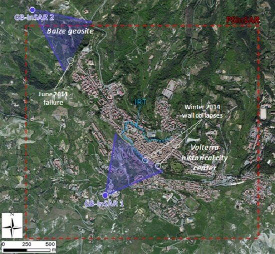
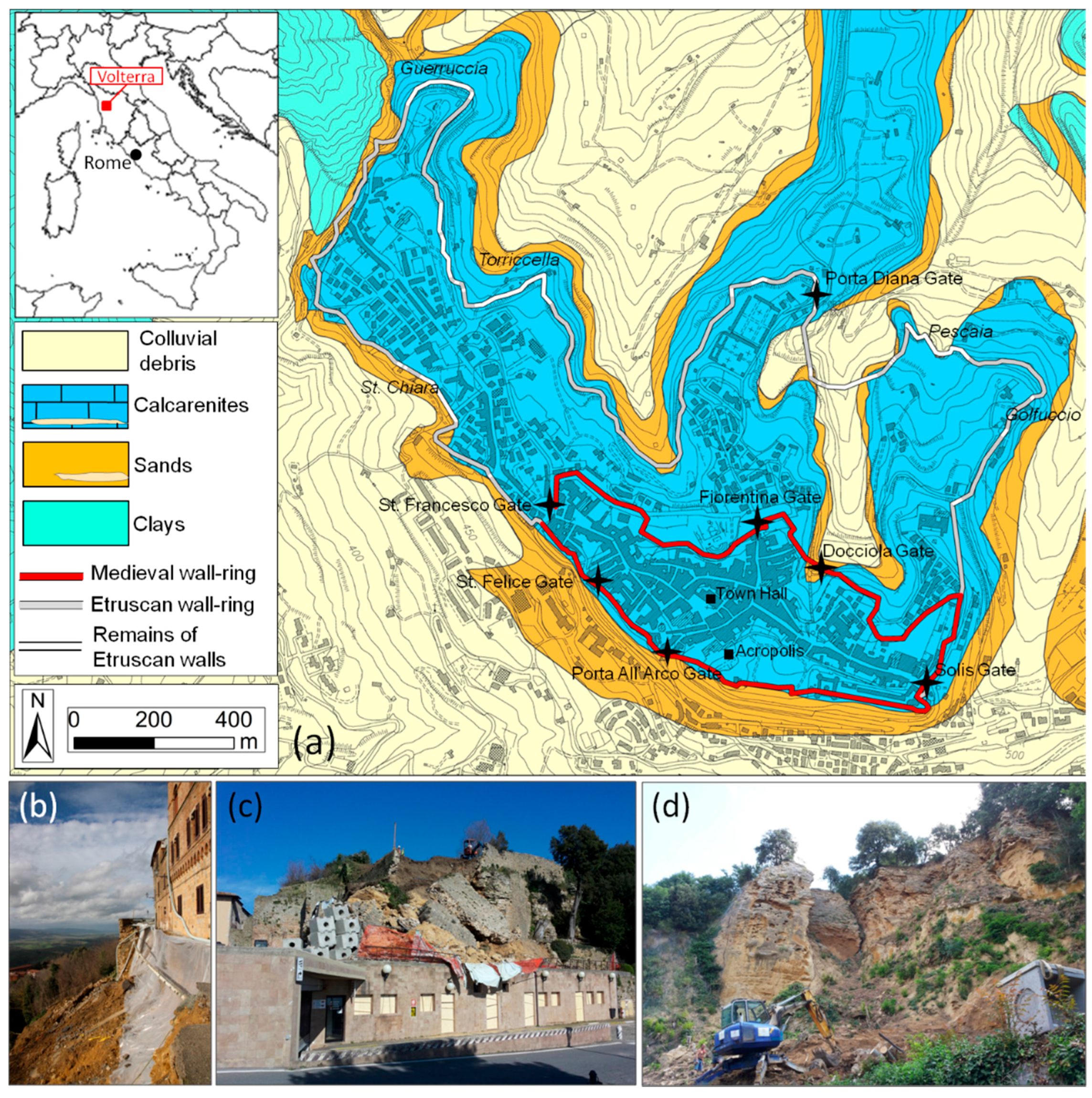
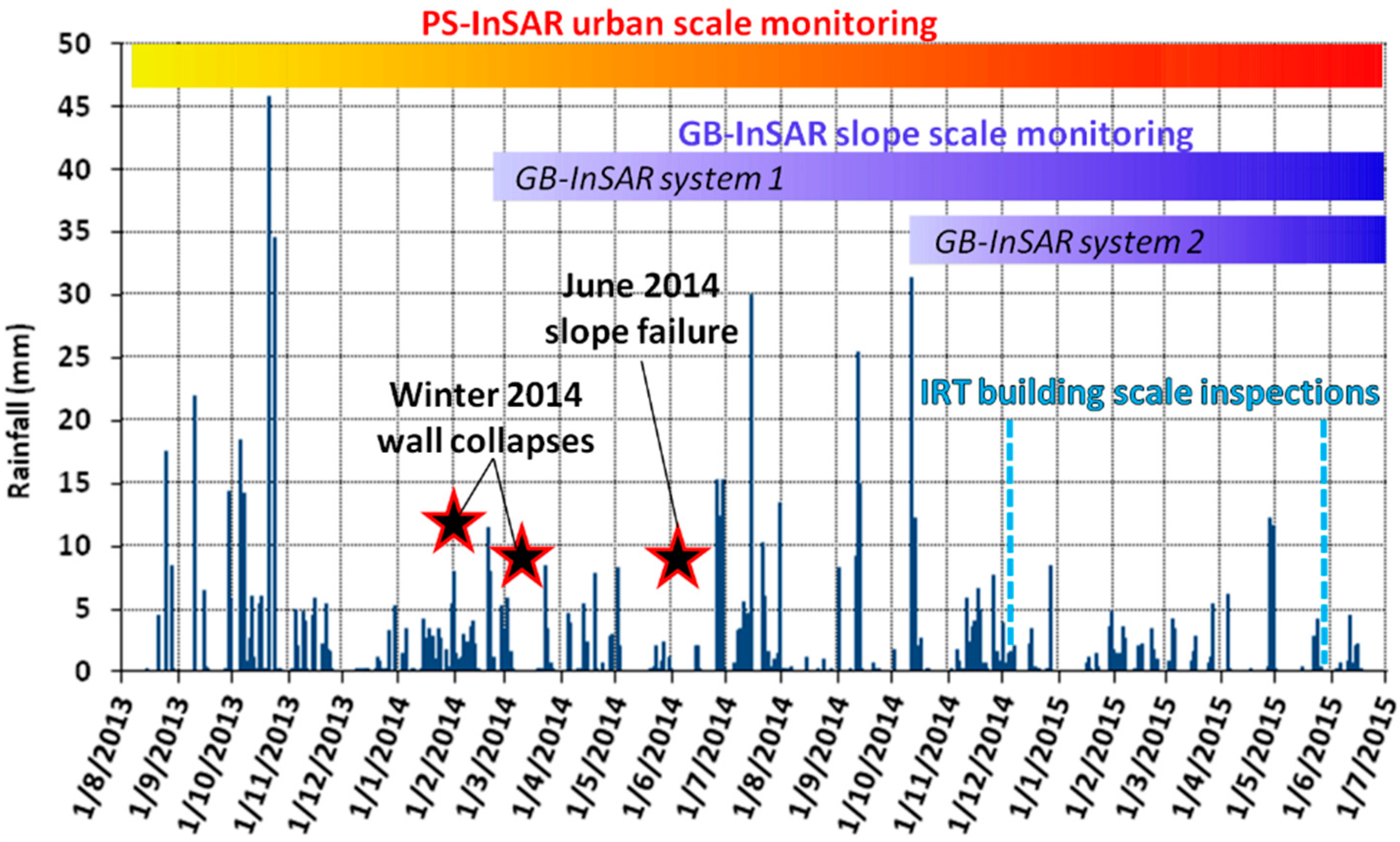
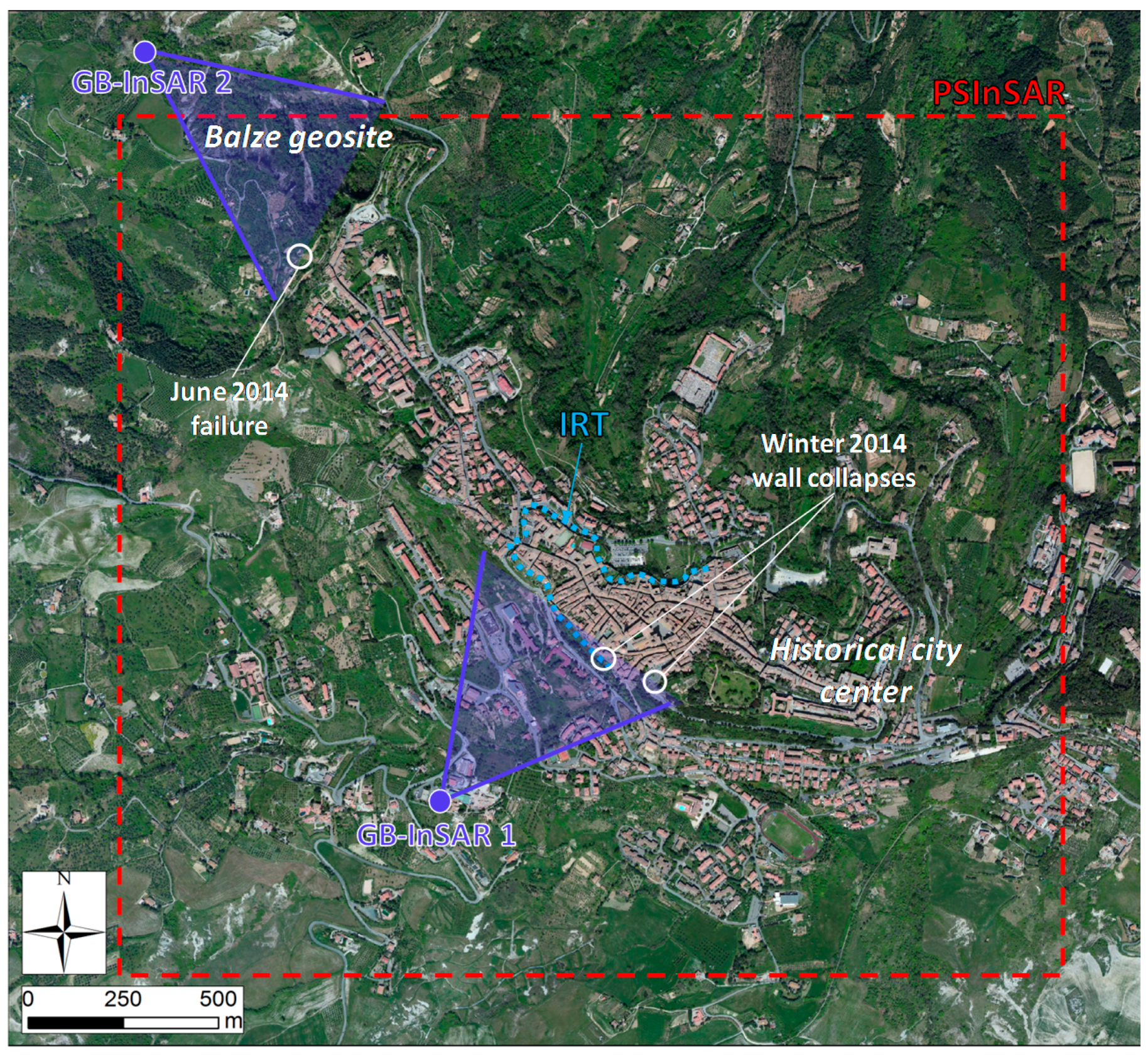
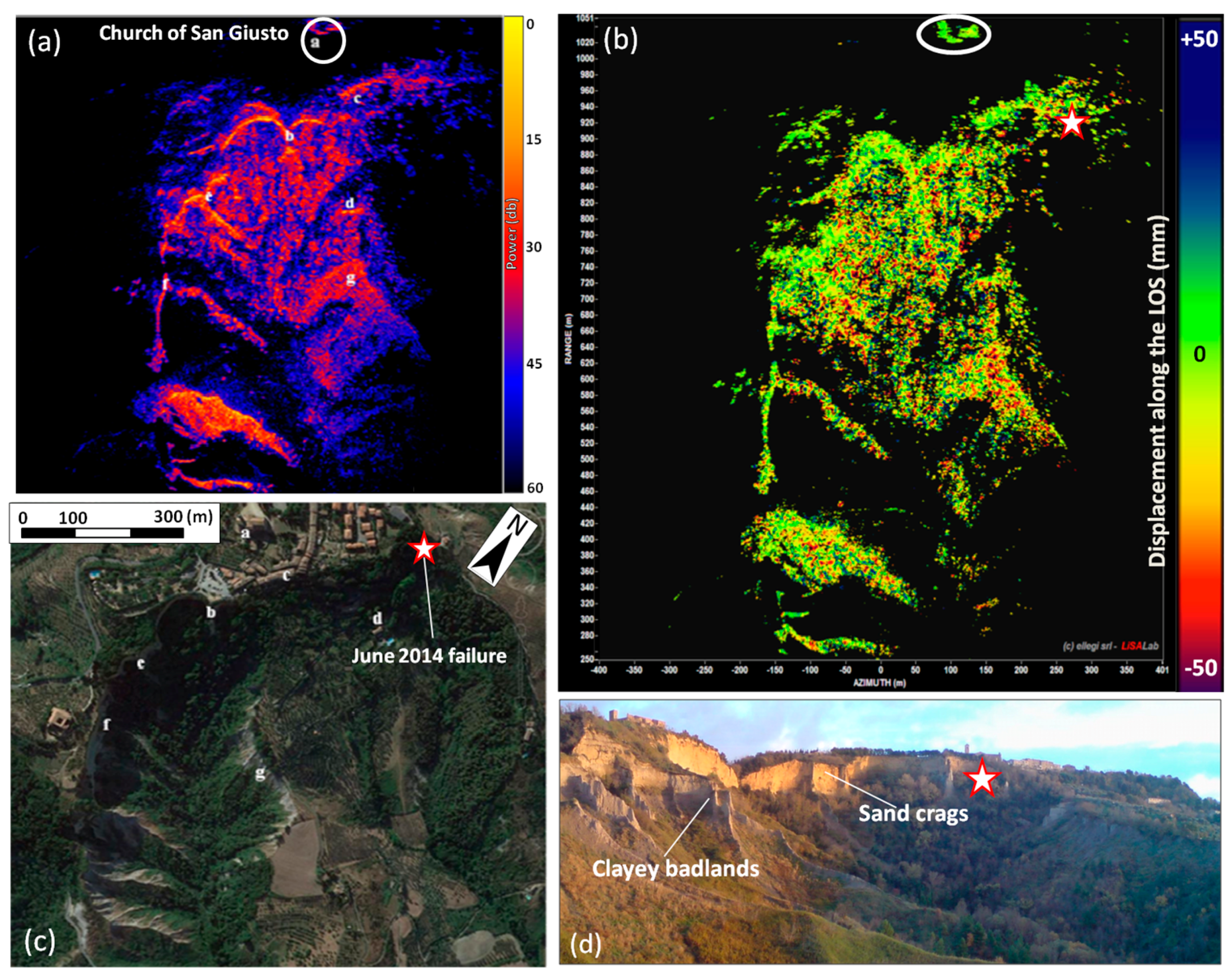
2. Study Area and Description of 2014 Failure Events
3. The Applied Remote Sensing Monitoring Techniques
3.1. Persistent Scatterer Synthetic Aperture Radar Interferometry (PS-InSAR)
3.2. Ground-Based Radar Interferometry (GB-InSAR)
3.3. Infrared Thermography (IRT)
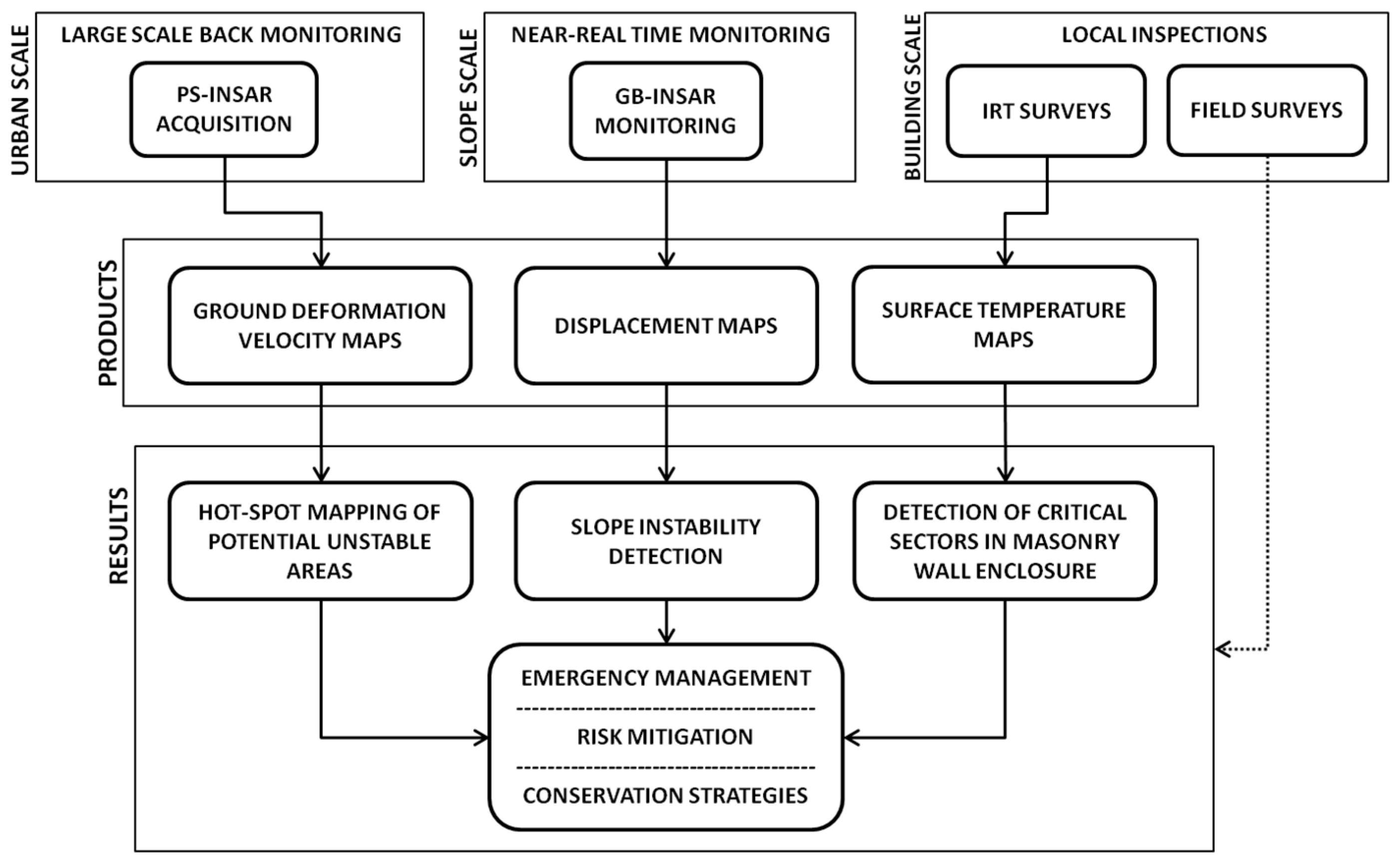
3.4. The Multiplatform Monitoring System
4. Results
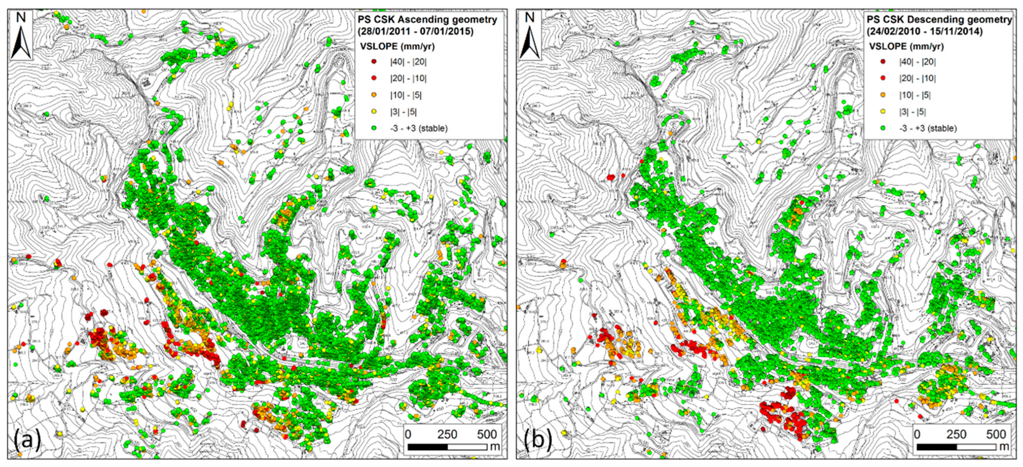
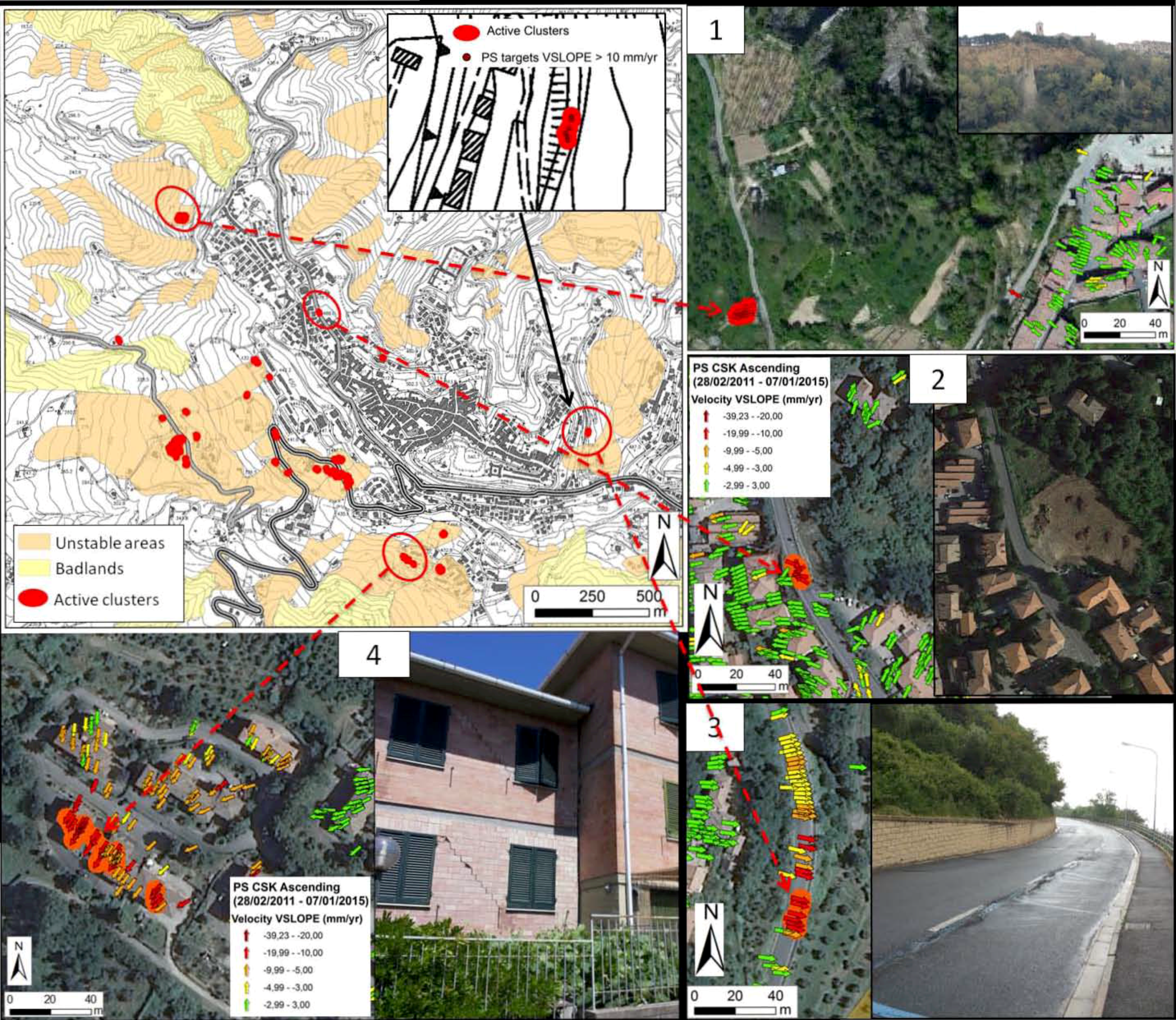
4.1. Persistent Scatterer Interferometry (PSI) Analysis and Results: Large-Scale Urban Detection
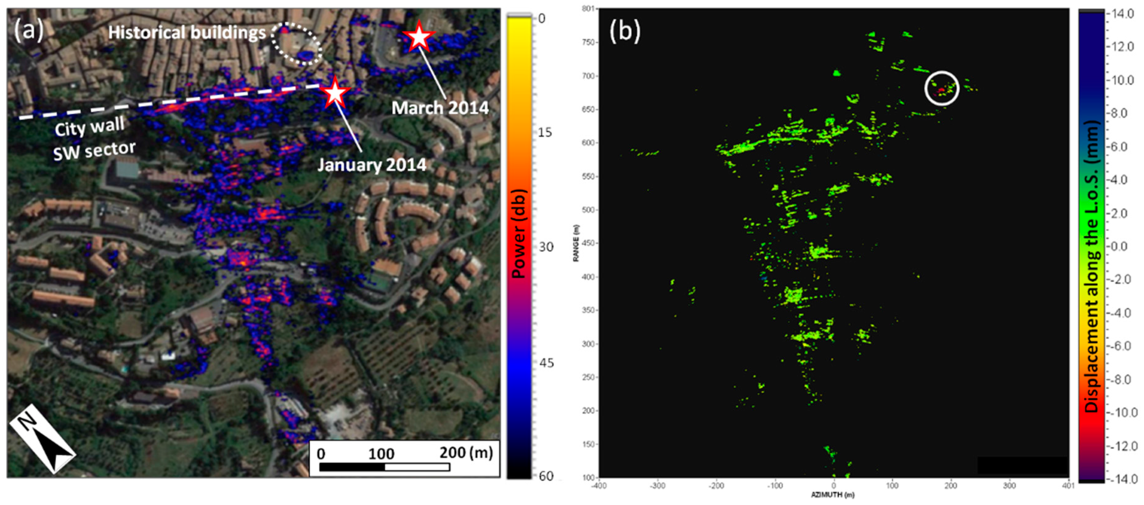
4.2. GB-InSAR Monitoring of the Medieval City Walls (Slope Scale Analysis)
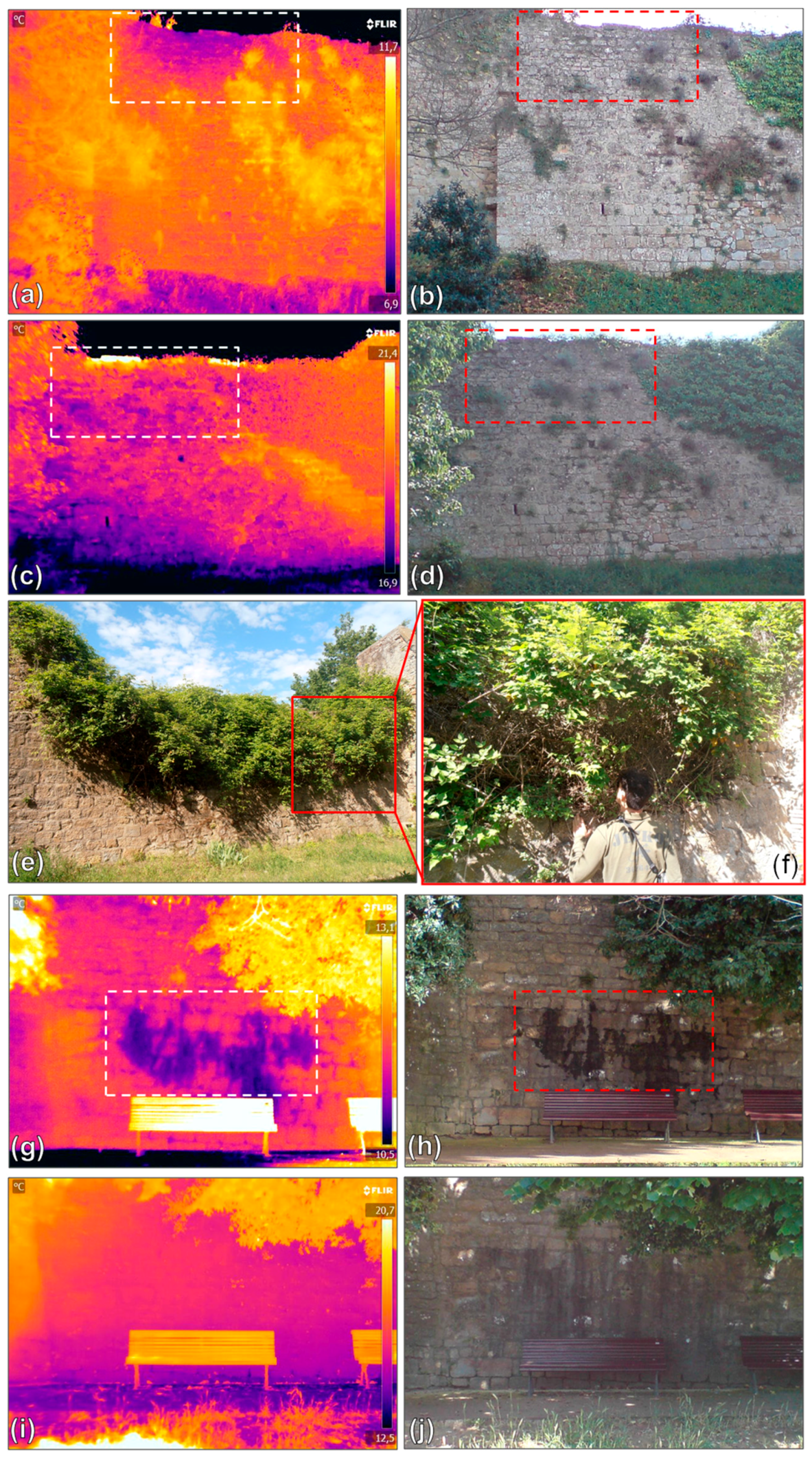
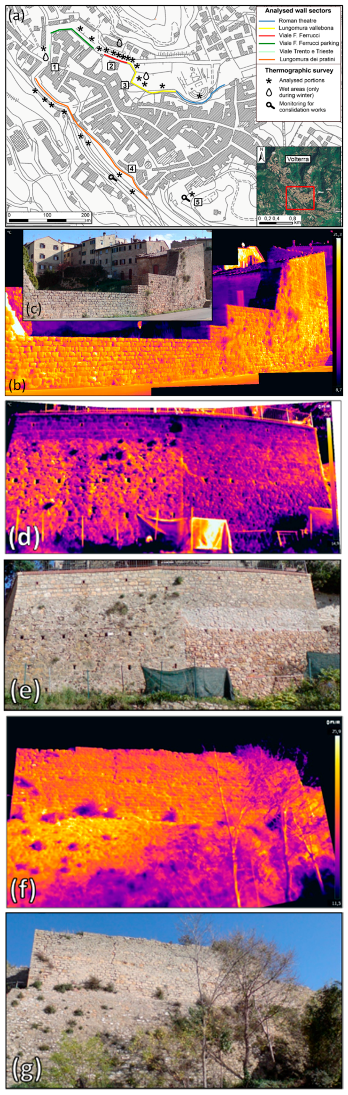
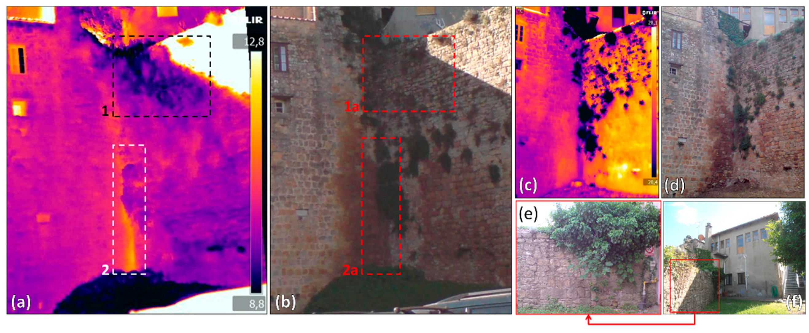
4.3. Building Scale IRT Survey
5. Discussion
6. Conclusions
Acknowledgments
Author Contributions
Conflicts of Interest
References
- Frodella, W.; Ciampalini, A.; Gigli, G.; Lombardi, L.; Raspini, F.; Nocentini, M.; Scardigli, C.; Casagli, N. Synergic use of satellite and ground based remote sensing methods for monitoring the San Leo rock cliff (Northern Italy). Geomorphology 2016, 264, 80–94. [Google Scholar] [CrossRef]
- Riveiro, B.; Jauregui, D.V.; Arias, P.; Armesto, J.; Jiang, R. An innovative method for remote measurement of minimum vertical underclearance in routine bridge inspection. Autom. Constr. 2012, 25, 34–40. [Google Scholar] [CrossRef]
- Tapete, D.; Morelli, S.; Fanti, R.; Casagli, N. Localising deformation along the elevation of linear structures: An experiment with space-borne InSAR and RTK GPS on the Roman Aqueducts in Rome, Italy. Appl. Geogr. 2015, 58, 65–83. [Google Scholar] [CrossRef] [Green Version]
- Taubenbock, H.; Esch, T.; Felbier, A.; Roth, A.; Dech, S. Pattern-based accuracy assessment of an urban footprint classification using TerraSAR-X data. IEEE Geosci. Remote Sens. Lett. 2011, 8, 278–282. [Google Scholar] [CrossRef]
- Tapete, D.; Gigli, G.; Mugnai, F.; Vannocci, P.; Pecchioni, E.; Morelli, S.; Fanti, R.; Casagli, N. Correlation between Erosion Patterns and Rockfall Hazard Susceptibility in Hilltop Fortifications by Terrestrial Laser Scanning and Diagnostic Investigations. In Proceedings of the 2012 IEEE International Geoscience and Remote Sensing Symposium, Munich, Germany, 22–27 July 2012; pp. 4809–4812.
- Bianchini, S.; Pratesi, F.; Nolesini, T.; Casagli, N. Building deformation assessment by means of persistent scatterer interferometry analysis on a landslide-affected area: The Volterra (Italy) case study. Remote Sens. 2015, 7, 4678–4701. [Google Scholar] [CrossRef]
- Delmonaco, G.; Leoni, G.; Margottini, C.; Spizichino, D. Implementation of advanced monitoring system network in the Siq of Petra (Jordan). In Engineering Geology for Society and Territory 8; Lollino, G., Jordan, D., Maruneanu, C., Christaras, B., Yoshinori, I., Margottini, C., Eds.; Springer International Publishing: Lausanne, Switzerland, 2015; pp. 299–303. [Google Scholar]
- Broussolle, J.; Kyovtorov, V.; Basso, M.; Castiglione, G.F.D.S.E.; Morgado, J.F.; Giuliani, R.; Oliveri, F.; Sammartino, P.F.; Tarchi, D. MELISSA, a new class of ground based InSAR system. An example of application in support to the Costa Concordia. ISPRS J. Photogramm. Remote Sens. 2014, 91, 50–58. [Google Scholar] [CrossRef]
- Pratesi, F.; Nolesini, T.; Bianchini, S.; Leva, D.; Lombardi, L.; Fanti, R.; Casagli, N. Early warning GBInSAR-based method for monitoring Volterra (Tuscany, Italy) city walls. IEEE J. Sel. Top. Appl. Earth Obs. Remote Sens. 2015, 8, 1753–1762. [Google Scholar] [CrossRef]
- Tarchi, D.; Ohlmer, E.; Sieber, A.J. Monitoring of structural changes by radar interferometry. Res. Nondestruct. Eval. 1997, 9, 213–225. [Google Scholar] [CrossRef]
- Tarchi, D.; Rudolf, H.; Pieraccini, M.; Atzeni, C. Remote monitoring of buildings using a ground-based SAR: Application to cultural heritage survey. Int. J. Remote Sens. 2000, 21, 3545–3551. [Google Scholar] [CrossRef]
- Tarchi, D.; Casagli, N.; Fanti, R.; Leva, D.; Luzi, G.; Pasuto, A.; Pieraccini, M.; Silvano, S. Landslide monitoring by using ground-based SAR interferometry: An example of application to the Tessina landslide in Italy. Eng. Geol. 2002, 68, 15–30. [Google Scholar] [CrossRef]
- Luzi, G.; Pieraccini, M.; Mecatti, D.; Noferini, L.; Guidi, G.; Moia, F.; Atzeni, C. Ground-based radar interferometry for landslides monitoring: Atmospheric and instrumental decorrelation sources on experimental data. IEEE Trans. Geosci. Remote Sens. 2004, 42, 2454–2466. [Google Scholar] [CrossRef]
- Luzi, G.; Monserrat, O.; Crosetto, M.; Copons, R.; Altimir, J. Ground-Based SAR Interferometry Applied to Landslide Monitoring in Mountainous Areas. In Proceedings of the Mountain Risks Conference: Bringing Science to Society, Firenze, Italy, 24–26 November 2010; pp. 24–26.
- Gigli, G.; Intrieri, E.; Lombardi, L.; Nocentini, M.; Frodella, W.; Balducci, M.; Venanti, L.D.; Casagli, N. Event scenario analysis for the design of rockslide countermeasures. J. Mount. Sci. 2014, 11, 1521–1530. [Google Scholar] [CrossRef]
- Grinzato, E.; Vavilov, V.; Kauppinen, T. Quantitative infrared thermography in buildings. Energy Build. 1998, 29, 1–9. [Google Scholar] [CrossRef]
- Avdelidis, N.P.; Moropoulou, A. Applications of infrared thermography for the investigation of historic structures. J. Cult. Herit. 2004, 5, 119–127. [Google Scholar] [CrossRef]
- Teza, G.; Marcato, G.; Castelli, E.; Galgaro, A. IRTROCK: A matlab toolbox for contactless recognition of surface and shallow weakness traces of a rock mass by infrared thermography. Comput. Geosci. 2012, 45, 109–118. [Google Scholar] [CrossRef]
- Gigli, G.; Frodella, W.; Garfagnoli, F.; Morelli, S.; Mugnai, F.; Menna, F.; Casagli, N. 3-D geomechanical rock mass characterization for the evaluation of rockslide susceptibility scenarios. Landslides 2014, 11, 131–140. [Google Scholar] [CrossRef]
- Frodella, W.; Morelli, S.; Fidolini, F.; Pazzi, V.; Fanti, R. Geomorphology of the Rotolon landslide (Veneto Region, Italy). J. Maps 2014, 10, 394–401. [Google Scholar] [CrossRef]
- Sabelli, R.; Cecchi, G.; Esposito, A.M. Mura Etrusche di Volterra, Conservazione e Valorizzazione; La Grafica Pisana: Bientina, Italy, 2012. (In Italian) [Google Scholar]
- Bianchini, S.; del Soldato, M.; Solari, L.; Nolesini, T.; Pratesi, F.; Moretti, S. Badland susceptibility assessment in Volterra municipality (Tuscany, Italy) by means of GIS and statistical analysis. Environ. Earth Sci. 2016, 75. [Google Scholar] [CrossRef]
- Terrenato, N. The romanization of Volaterrae (Volterra). J. Rom. Stud. 1998, 88, 94–114. [Google Scholar] [CrossRef]
- Cateni, G.; Furiesi, A. La Città di Pietra. Mura Etrusche e Medievali di Volterra; Pacini: Pisa, Italy, 2006. (In Italian) [Google Scholar]
- Esposito, A.; Malesani, M.; Sabelli, R. Attività della Soprintendenza per i Beni Archeologici della Toscana nel Territorio Comunale di Volterra dal 1999 al 2003. In Proceedings of the VI Convegno Beni Ambientali e Culturali nella Città Storica, Volterra, Italy, 13–14 June 2003; pp. 16–171. (In Italian)
- Bonamici, M. Contributo alla Cinta Muraria Arcaica di Volterra. In Proceedings of the la Città Murata in Etruria 25th Convegno di Studi Italici, Chianciano Terme, Italy, 30 March–3 April 2005; pp. 337–352. (In Italian)
- Ferretti, A.; Prati, C.; Rocca, F. Nonlinear subsidence rate estimation using Permanent Scatterers in differential SAR interferometry. IEEE Trans. Geosci. Remote Sens. 2000, 38, 2202–2212. [Google Scholar] [CrossRef]
- Ferretti, A.; Prati, C.; Rocca, F. Permanent scatterers InSAR interferometry. IEEE Trans. Geosci. Remote Sens. 2001, 39, 8–20. [Google Scholar] [CrossRef]
- Hooper, A.; Zebker, H.; Segall, P.; Kampes, B. A new method for measuring deformation on volcanoes and other natural terrains using InSAR persistent scatterers. Geophys. Res. Lett. 2004, 31. [Google Scholar] [CrossRef]
- Massironi, M.; Zampieri, D.; Bianchi, M.; Schiavo, A.; Franceschini, A. Use of PS™ data to infer active tectonics: Clues on the differential uplift across the Giudicarie belt (Central-Eastern Alps, Italy). Tectonophysics 2009, 476, 297–303. [Google Scholar] [CrossRef]
- Costantini, M.; Iodice, A.; Magnapane, L.; Pietranera, L. Monitoring Terrainmovements by Means of Sparse SAR Differential Interferometric Measurements. In Proceedings of the IEEE 2000 International Geoscience and Remote Sensing Symposium, Honolulu, HI, USA, 24–28 July 2000; pp. 3225–3227.
- Ferretti, A.; Fumagalli, A.; Novali, F.; Prati, C.; Rocca, F.; Rucci, A. Higher-order permanent scatterers analysis. Eurasip J. Appl. Signal Process. 2005, 20, 3231–3242. [Google Scholar] [CrossRef]
- Hanssen, R.S. Satellite radar interferometry for deformation monitoring: A priori assessment of feasibility and accuracy. Int. J. Appl. Earth Obs. Geoinform. 2005, 6, 253–260. [Google Scholar] [CrossRef]
- Raucoules, D.; Colesanti, C.; Carnec, C. Use of SAR interferometry for detecting and assessing ground subsidence. Comptes Rendus Geosci. 2009, 339, 289–302. [Google Scholar] [CrossRef]
- Crosetto, M.; Monserrat, O.; Iglesias, R.; Crippa, B. Persistent scatterer interferometry: Potential, limits and initial C- and X-band comparison. Photogramm. Eng. Remote Sens. 2010, 76, 1061–1069. [Google Scholar] [CrossRef]
- Ferretti, A.; Fumagalli, A.; Novali, F.; Prati, C.; Rocca, F.; Rucci, A. A new algorithm for processing interferometric data-stacks: SqueeSAR. IEEE Trans. Geosci. Remote Sens. 2011, 49, 3460–3470. [Google Scholar] [CrossRef]
- Tofani, V.; Raspini, F.; Catani, F.; Casagli, N. Persistent scatterer interferometry (PSI) technique for landslide characterization and monitoring. Remote Sens. 2013, 5, 1045–1065. [Google Scholar] [CrossRef]
- Bellotti, M.; Bianchi, D.; Colombo, A.; Ferretti, A. Tamburini, A. Advanced InSAR techniques to support landslide monitoring. In Mathematics of Planet Earth Lecture Notes in Earth System Sciences; Pardo-Igúzquiza, E., Guardiola-Albert, C., Heredia, J., Moreno-Merino, L., Durán, J.J., Vargas-Guzmán, J.A., Eds.; Springer: Berlin, Germany, 2014; pp. 287–290. [Google Scholar]
- Notti, D.; Herrera, G.; Bianchini, S.; Meisina, C.; García-Davalillo, J.C.; Zucca, F. A methodology for improving landslide PSI data analysis. Int. J. Remote Sens. 2014, 35, 2186–2214. [Google Scholar]
- Zebker, H.A.; Goldstein, R.M. Topographic mapping from interferometric synthetic aperture radar observations. J. Geophys. Res. 1986, 91, 4993–4999. [Google Scholar] [CrossRef]
- Curlander, J.C.; McDonough, R.N. Synthetic Aperture Radar: Systems and Signal Processing; Wiley: New York, NY, USA, 1991; p. 672. [Google Scholar]
- Bamler, R.; Hartl, P. Synthetic aperture radar interferometry. Inverse Probl. 1998, 14, R1. [Google Scholar] [CrossRef]
- Rudolf, H.; Leva, D.; Tarchi, D.; Sieber, A.J. A Mobile and Versatile SAR System. In Proceedings of the IEEE 1999 International Geoscience and Remote Sensing Symposium, Hamburg, Germany, 28 June–2 July 1999; pp. 592–594.
- Pieraccini, M.; Tarchi, D.; Rudolf, H.; Leva, D.; Luzi, G.; Bartoli, G.; Atzeni, C. Structural static testing by interferometric synthetic radar. NDT E Int. 2000, 33, 565–570. [Google Scholar] [CrossRef]
- Pieraccini, M.; Casagli, N.; Luzi, G.; Tarchi, D.; Mecatti, D.; Noferini, L.; Atzeni, C. Landslide monitoring by ground-based radar interferometry: A field test in Valdarno (Italy). Int. J. Remote Sens. 2002, 24, 1385–1391. [Google Scholar] [CrossRef]
- Monserrat, O.; Crosetto, M.; Luzi, G. A review of ground-based SAR interferometry for deformation measurement. ISPRS J. Photogramm. Remote Sens. 2014, 93, 40–48. [Google Scholar] [CrossRef]
- Maldague, X. Theory and Practice of Infrared Technology for Non Destructive Testing; John-Wiley & Sons: New York, NY, USA, 2001; p. 684. [Google Scholar]
- Laguela, S.; González-Jorge, H.; Armesto, J.; Arias, P. Calibration and verification of thermographic cameras for geometric measurements. Infrared Phys. Technol. 2011, 54, 92–99. [Google Scholar] [CrossRef]
- Aggelis, D.G.; Kordatos, E.Z.; Soulioti, D.V.; Matikas, T.E. Combined use of thermography and ultrasound for the characterization of subsurface cracks in concrete. Constr. Build. Mater. 2010, 24, 1888–1897. [Google Scholar] [CrossRef]
- Avdelidis, N.P.; Moropoulou, A.; Theoulakis, P. Detection of water deposits and movement in porous materials by infrared imaging. Infrared Phys. Technol. 2003, 44, 183–190. [Google Scholar] [CrossRef]
- Tavukçuoğlu, A.; Dügünes, E.N.; Caner-Saltık, E.N.; Demirci, Ş. Use of IR thermography for the assessment of surface-water drainage problems in a historical building, Ağzıkarahan (Aksaray). Turkey. NDT E Int. 2005, 38, 402–410. [Google Scholar] [CrossRef]
- Meola, C. Infrared thermography of masonry structures. Infrared Phys. Technol. 2006, 49, 228–233. [Google Scholar] [CrossRef]
- Grinzato, E.; Rosina, E. Infrared and thermal testing for conservation of historic building. In Non Destructive Testing Handbook, Infrared and Thermal Testing, 3rd ed.; American Society For Nondestructive Testing (ASNT): Columbus, OH, USA, 2001; pp. 942–954. [Google Scholar]
- Grinzato, E.; Bressan, C.; Marinetti, S.; Bison, P.G.; Bonacina, C. Monitoring of the Scrovegni Chapel by IR thermography: Giotto at infrared. Infrared Phys. Technol. 2002, 43, 165–169. [Google Scholar] [CrossRef]
- Paoletti, D.; Ambrosini, D.; Sfarra, S.; Bisegna, F. Preventive thermographic diagnosis of historical buildings for consolidation. J. Cult. Herit. 2003, 14, 116–121. [Google Scholar] [CrossRef]
- Cabrelles, M.; Galcerá, S.; Navarro, S.; Lerma, J.L.; Akasheh, T.; Haddad, N. Integration of 3D Laser Scanning, Photogrammetry and Thermography to Record Architectural Monuments. In Proceedings of the 22nd International CIPA Symposium, Kyoto, Japan, 11–15 October 2009.
- De Freitas, S.S.; de Freitas, V.P.; Barreira, E. Detection of façade plaster detachments using infrared thermography, a nondestructive technique. Constr. Build. Mater. 2014, 70, 80–87. [Google Scholar] [CrossRef]
- Alba, M.I.; Barazzetti, L.; Scaioni, M.; Rosina, E.; Previtali, M. Mapping infrared data on terrestrial laser scanning 3D models of buildings. Remote Sens. 2011, 3, 1847–1870. [Google Scholar] [CrossRef]
- Ludwig, N.; Redaelli, V.; Rosina, E.; Augelli, F. Moisture detection in wood and plaster by IR thermography. Infrared Phys. Technol. 2004, 46, 161–166. [Google Scholar] [CrossRef]
- FLIR, 2012, FLIR Reporter Professional 9. Available online: http://www.flir.com/cs/emea/en/view/?id=42405 (accessed on 30 June 2015).
- FLIR, 2014, FLIR ResearchIR 3.4. sp3. Available online: http://support.flir.com/DsDownload/Assets/T198206 en_40.pdf (accessed on 30 June 2015).
- Bianchini, S.; Herrera, G.; Mateos, R.M.; Notti, D.; Garcia, I.; Mora, O.; Moretti, S. Landslide activity maps generation by means of persistent scatterer interferometry. Remote Sens. 2013, 5, 6198–6222. [Google Scholar] [CrossRef]
- Mansour, M.F.; Morgenstern, N.R.; Derek Martin, C. Expected damage from displacement of slow-moving slides. Landslides 2011, 8, 117–131. [Google Scholar] [CrossRef]
- Meisina, C.; Zucca, F.; Notti, D.; Colombo, A.; Cucchi, A.; Savio, G.; Bianchi, M. Geological interpretation of PSInSAR data at regional scale. Sensors 2008, 8, 7469–7492. [Google Scholar] [CrossRef]
- Cigna, F.; Bianchini, S.; Righini, G.; Proietti, C.; Casagli, N. Updating landslide inventory maps in mountain areas by means of Persistent Scatterer Interferometry (PSI) and photo-interpretation: Central Calabria (Italy) case study. In Mountain Risks: Bringing Science to Society; CERG Editions: Strasbourg, France, 2010; pp. 24–26. [Google Scholar]
- Maierhofer, C.; Leipold, S. Radar investigation of masonry structures. NDT E Int. 2001, 34, 139–147. [Google Scholar] [CrossRef]
- Kandemir-Yucel, A.; Tavukcuoglu, A.; Caner-Saltik, E.N. In situ assessment of structural timber elements of a historic building by infrared thermography and ultrasonic velocity. Infrared Phys. Technol. 2007, 49, 243–248. [Google Scholar] [CrossRef]
- Eschmann, C.; Kuo, C.M.; Kuo, C.H.; Boller, C. Unmanned Aircraft Systems for Remote Building Inspection and Monitoring. In Proceedings of the 6th European Workshop on Structural Health Monitoring, Dresden, Germany, 3–6 June 2012.
- Pavlidis, I.; Symosek, P.; Fritz, B.; Bazakos, M.; Papanikolopoulos, N. Automatic detection of vehicle occupants—The imaging problem and its solution. Mach. Vis. Appl. 2000, 11, 313–320. [Google Scholar] [CrossRef]
- Pavlidis, I.; Morellas, V.; Papanikolopoulos, N. A vehicle occupant counting system based on near-infrared phenomenology and fuzzy neural classification. IEEE Trans. Int. Transp. Syst. 2000, 1, 72–85. [Google Scholar] [CrossRef]


| Feature | PS | GB-InSAR-1 | GB-InSAR-2 | IRT |
|---|---|---|---|---|
| Wavelength | X-band (3.1 cm) | Ku band (1.35 cm) | Ku band (1.35 cm) | LW-IR (7.5–13 µ) |
| Revisiting time | 16 days | ≈4 min | ≈1 min | 2 surveys/year |
| Image resolution | 3 × 3 m | 0.3 (@100 m) × 0.75 | 0.8 (@100 m) × 1 | 0.65 mrad |
| Coverage/Maximum distance/Range | 24 km2 | 800 m | 1050 m | (−40 + 500 °C) |
| Accuracy | ±1–5 mm | <1 mm | <1 mm | ±2 °C |
| Acquisition date | 24/02/2010–07/01/2015 | 19/02/2014–26/11/2015 | 27/01/2015–26/11/2015 | 25/05/2015–02/12/2015 |
© 2016 by the authors; licensee MDPI, Basel, Switzerland. This article is an open access article distributed under the terms and conditions of the Creative Commons Attribution (CC-BY) license (http://creativecommons.org/licenses/by/4.0/).
Share and Cite
Nolesini, T.; Frodella, W.; Bianchini, S.; Casagli, N. Detecting Slope and Urban Potential Unstable Areas by Means of Multi-Platform Remote Sensing Techniques: The Volterra (Italy) Case Study. Remote Sens. 2016, 8, 746. https://doi.org/10.3390/rs8090746
Nolesini T, Frodella W, Bianchini S, Casagli N. Detecting Slope and Urban Potential Unstable Areas by Means of Multi-Platform Remote Sensing Techniques: The Volterra (Italy) Case Study. Remote Sensing. 2016; 8(9):746. https://doi.org/10.3390/rs8090746
Chicago/Turabian StyleNolesini, Teresa, William Frodella, Silvia Bianchini, and Nicola Casagli. 2016. "Detecting Slope and Urban Potential Unstable Areas by Means of Multi-Platform Remote Sensing Techniques: The Volterra (Italy) Case Study" Remote Sensing 8, no. 9: 746. https://doi.org/10.3390/rs8090746
APA StyleNolesini, T., Frodella, W., Bianchini, S., & Casagli, N. (2016). Detecting Slope and Urban Potential Unstable Areas by Means of Multi-Platform Remote Sensing Techniques: The Volterra (Italy) Case Study. Remote Sensing, 8(9), 746. https://doi.org/10.3390/rs8090746