
Imaging Land Subsidence Induced by Groundwater Extraction in Beijing (China) Using Satellite Radar Interferometry


 ,
,  ,
, 
Abstract
:
1. Introduction
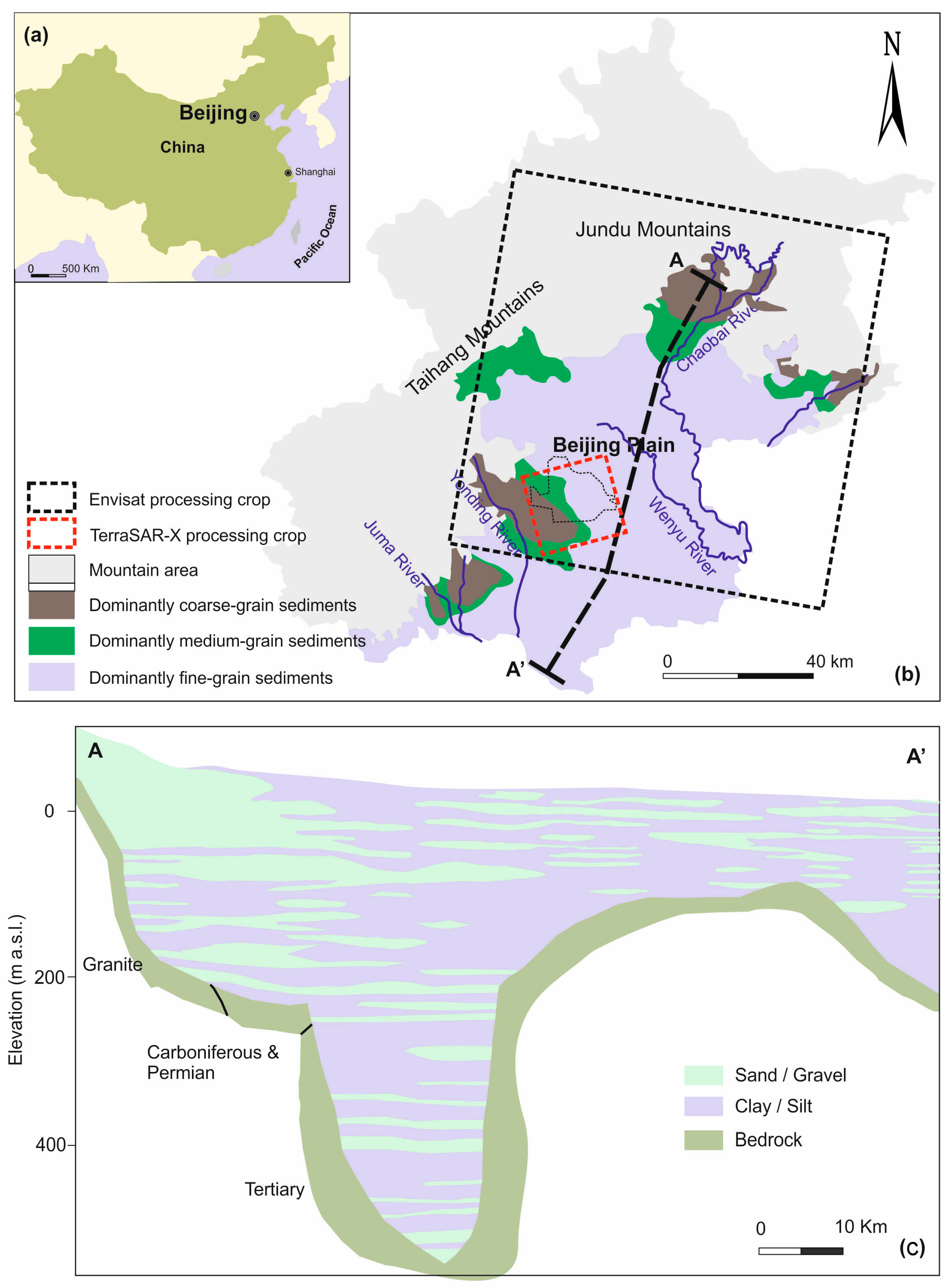
2. Description of the Beijing Basin
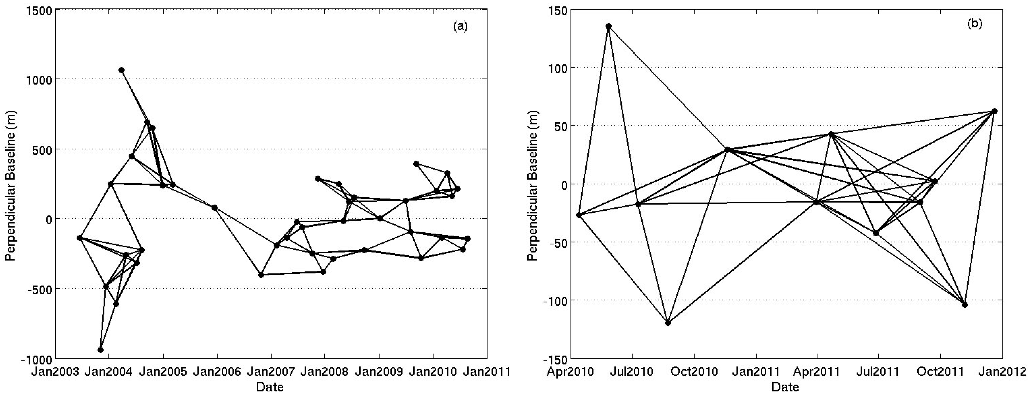
3. InSAR Processing
4. Results
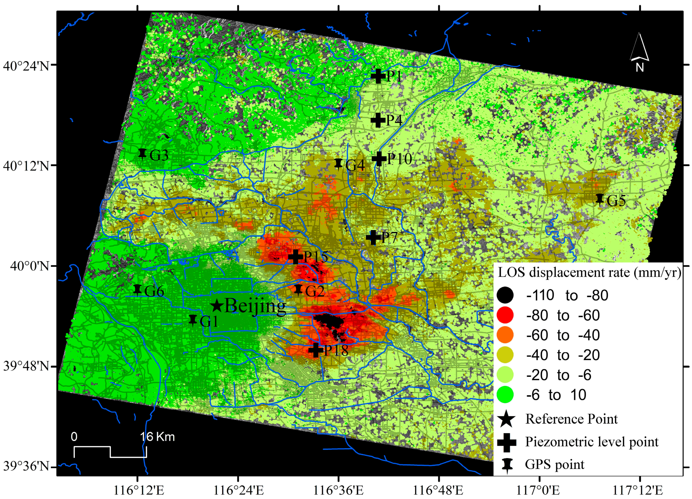
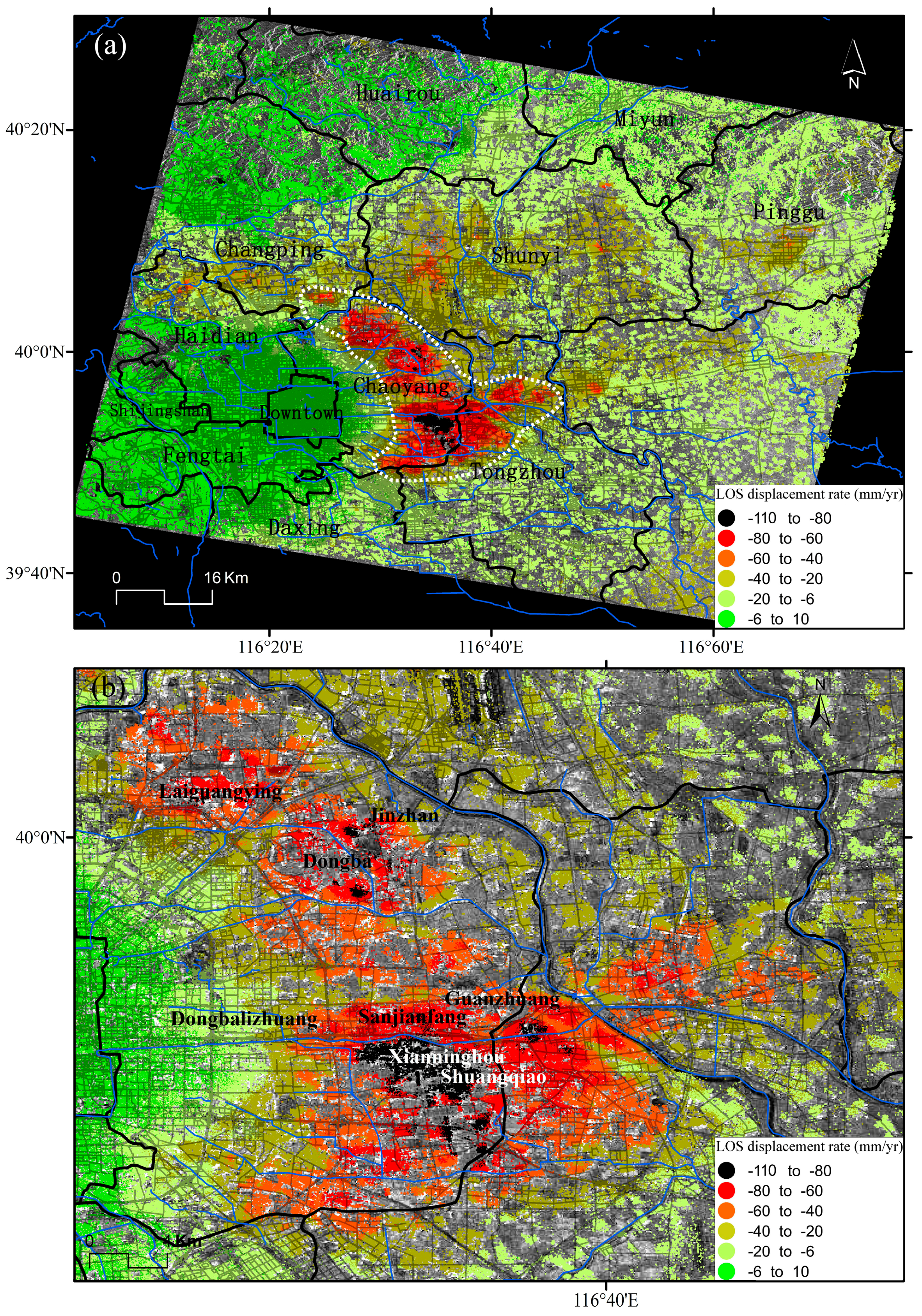
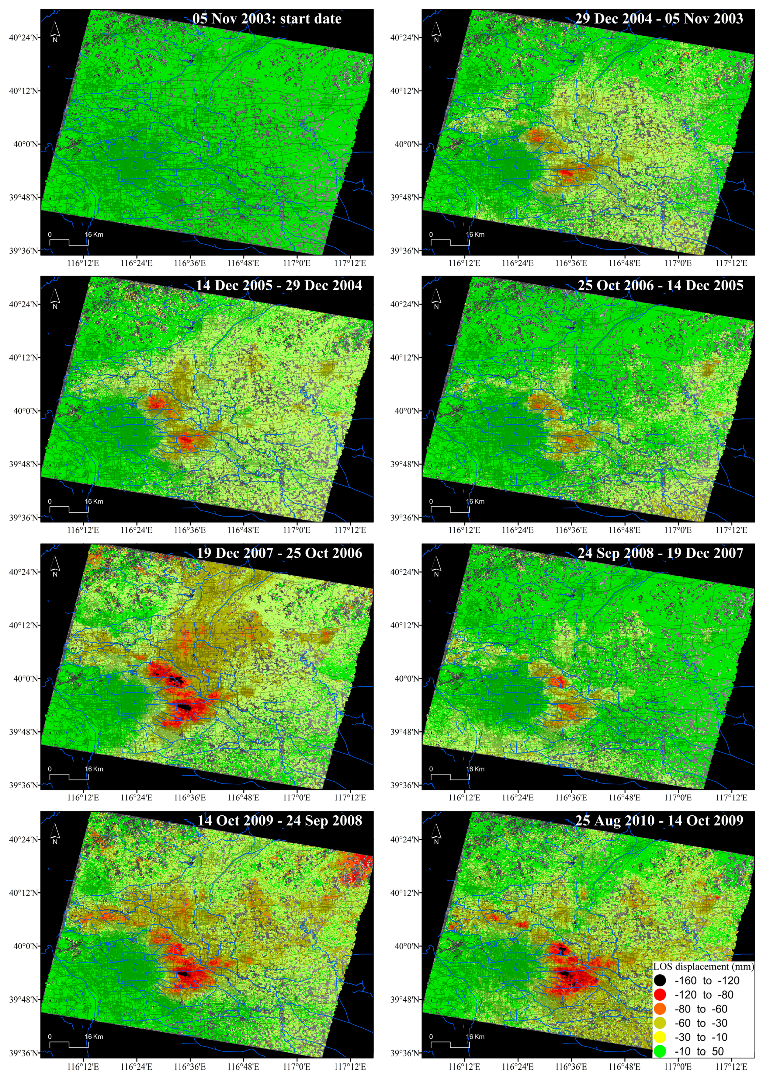
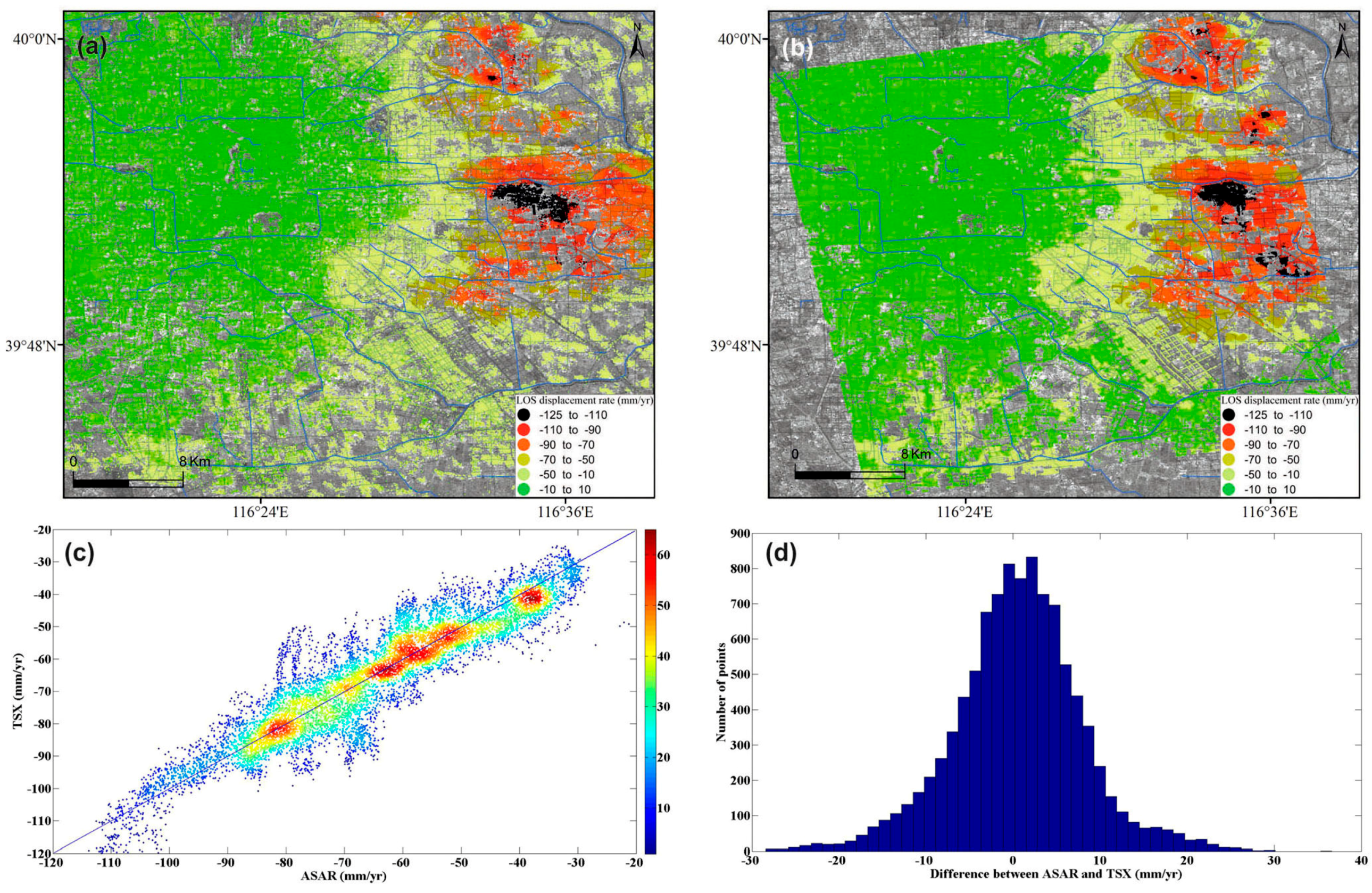
4.1. InSAR-Derived Land Subsidence Maps
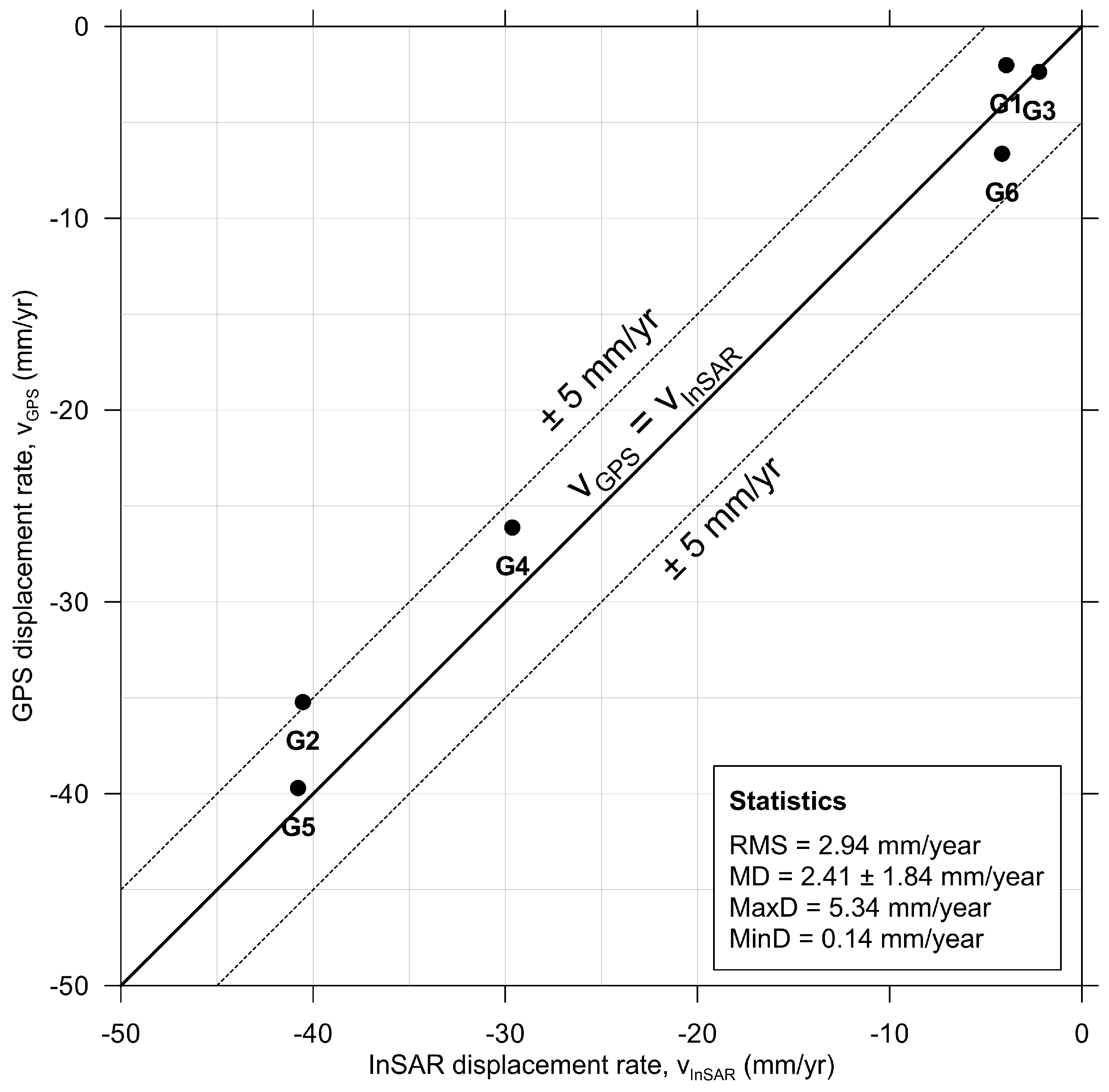
4.2. InSAR Data Validation
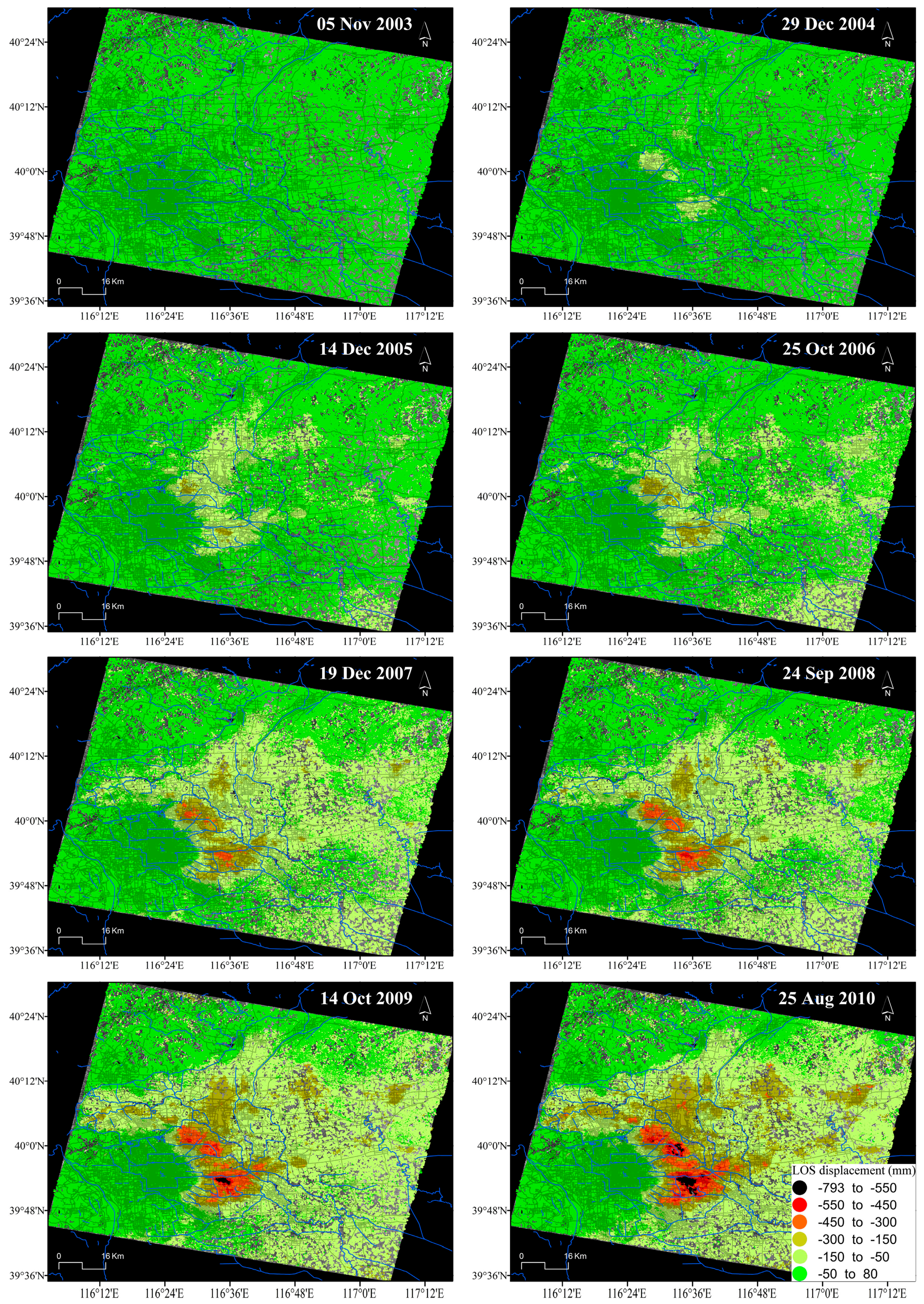
4.3. Spatio-Temporal Analysis of Land Subsidence
5. Discussion
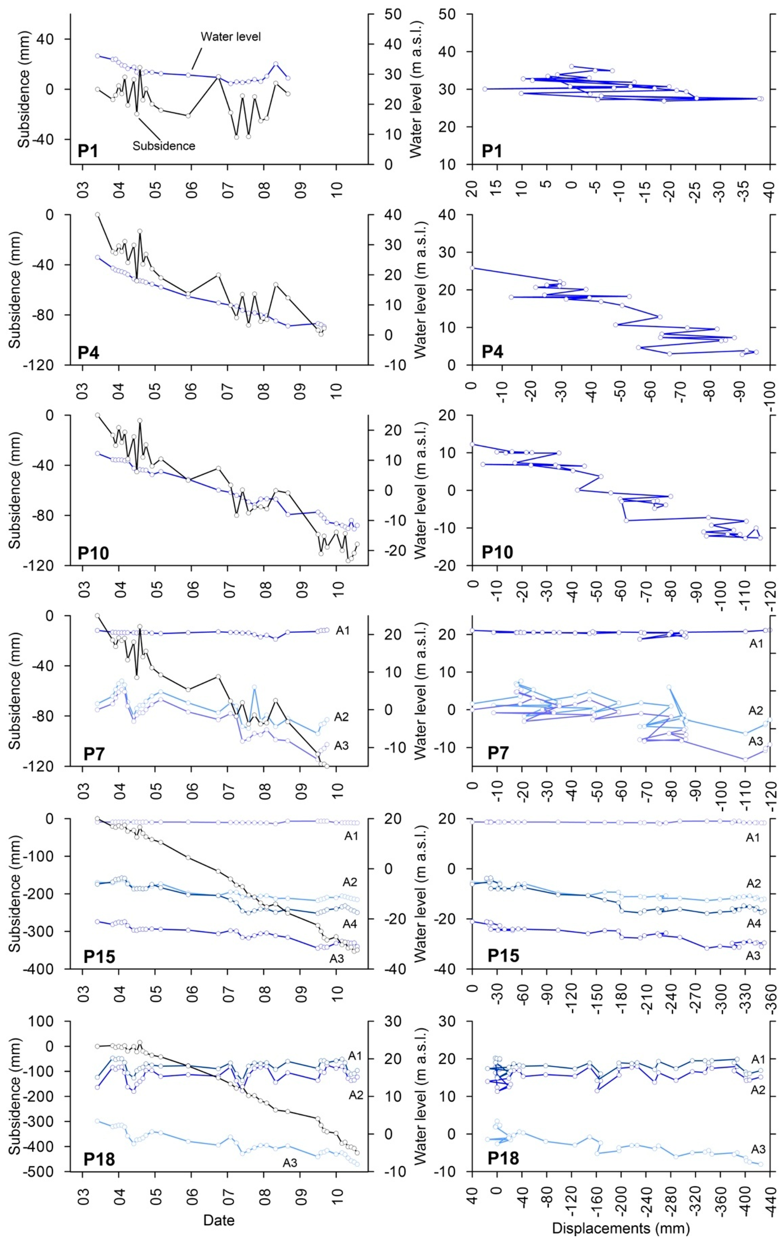
5.1. Relationships between Land Subsidence and Groundwater Level
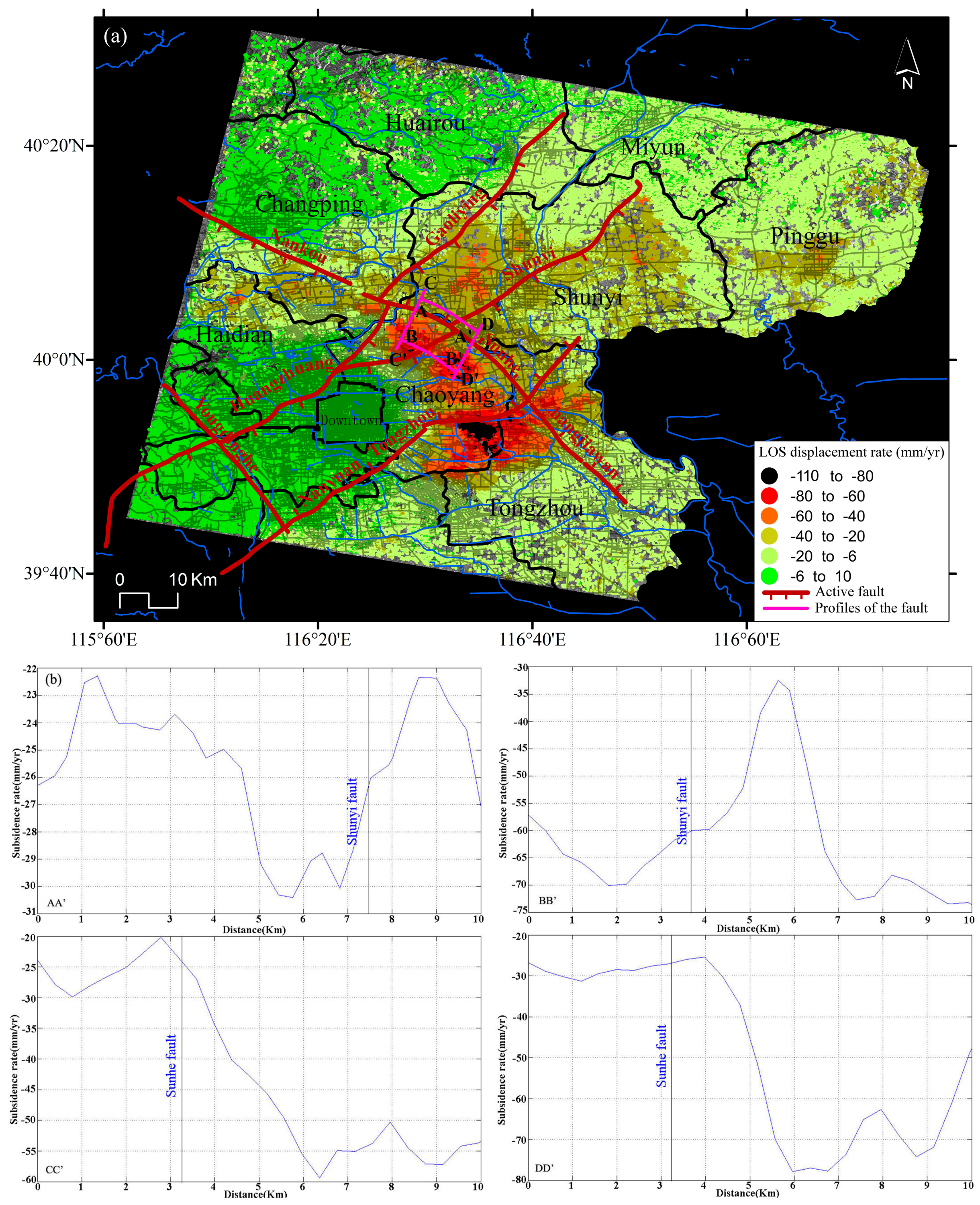
5.2. Relationships between Land Subsidence and Geological Structures
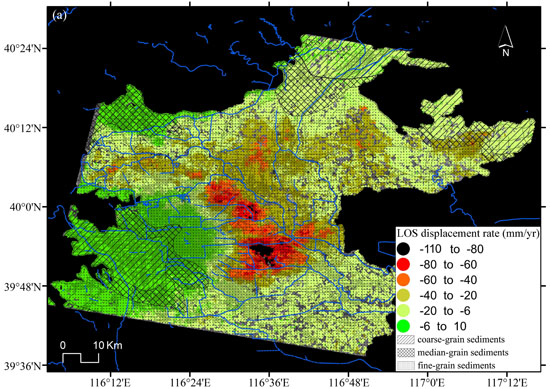
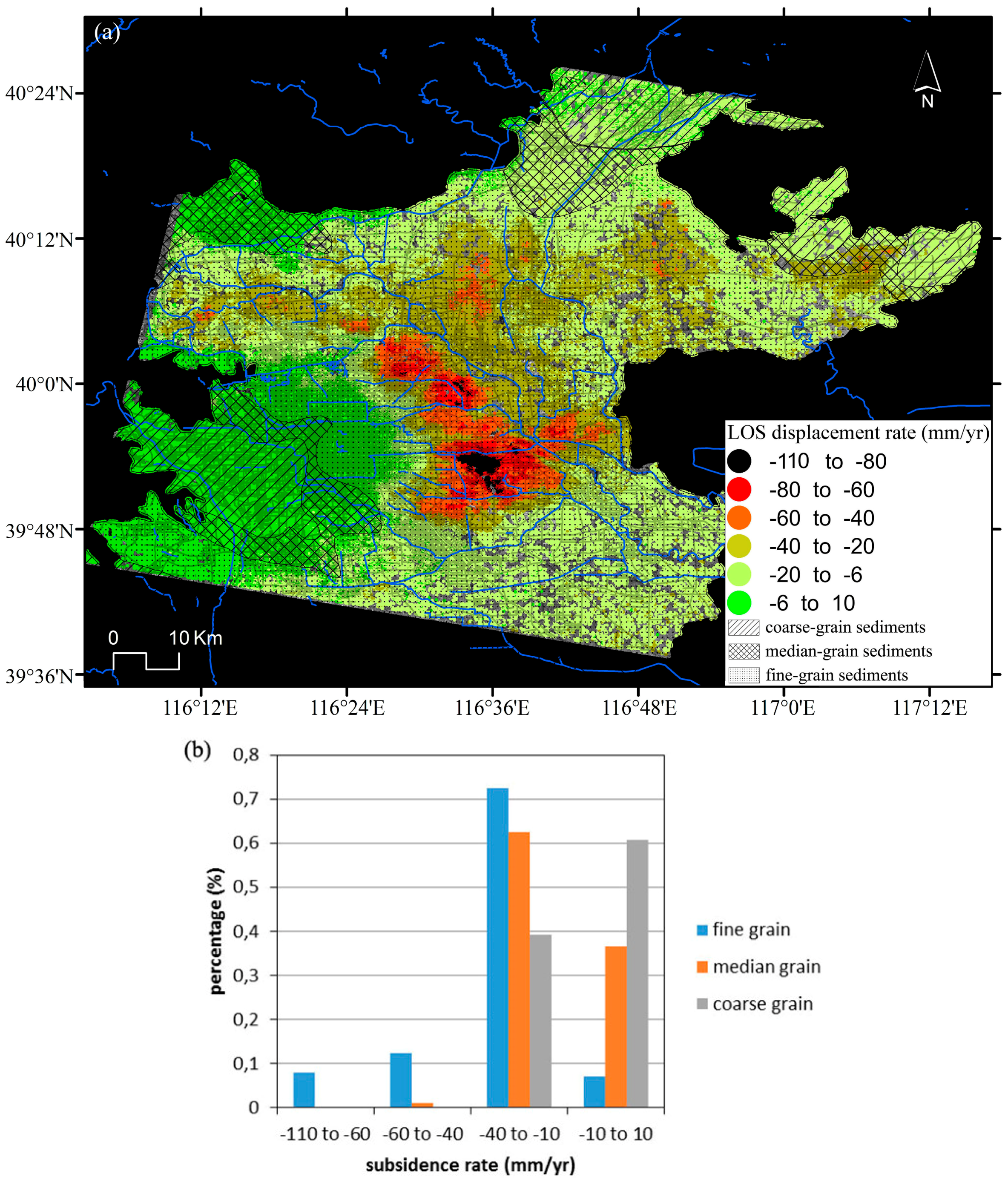
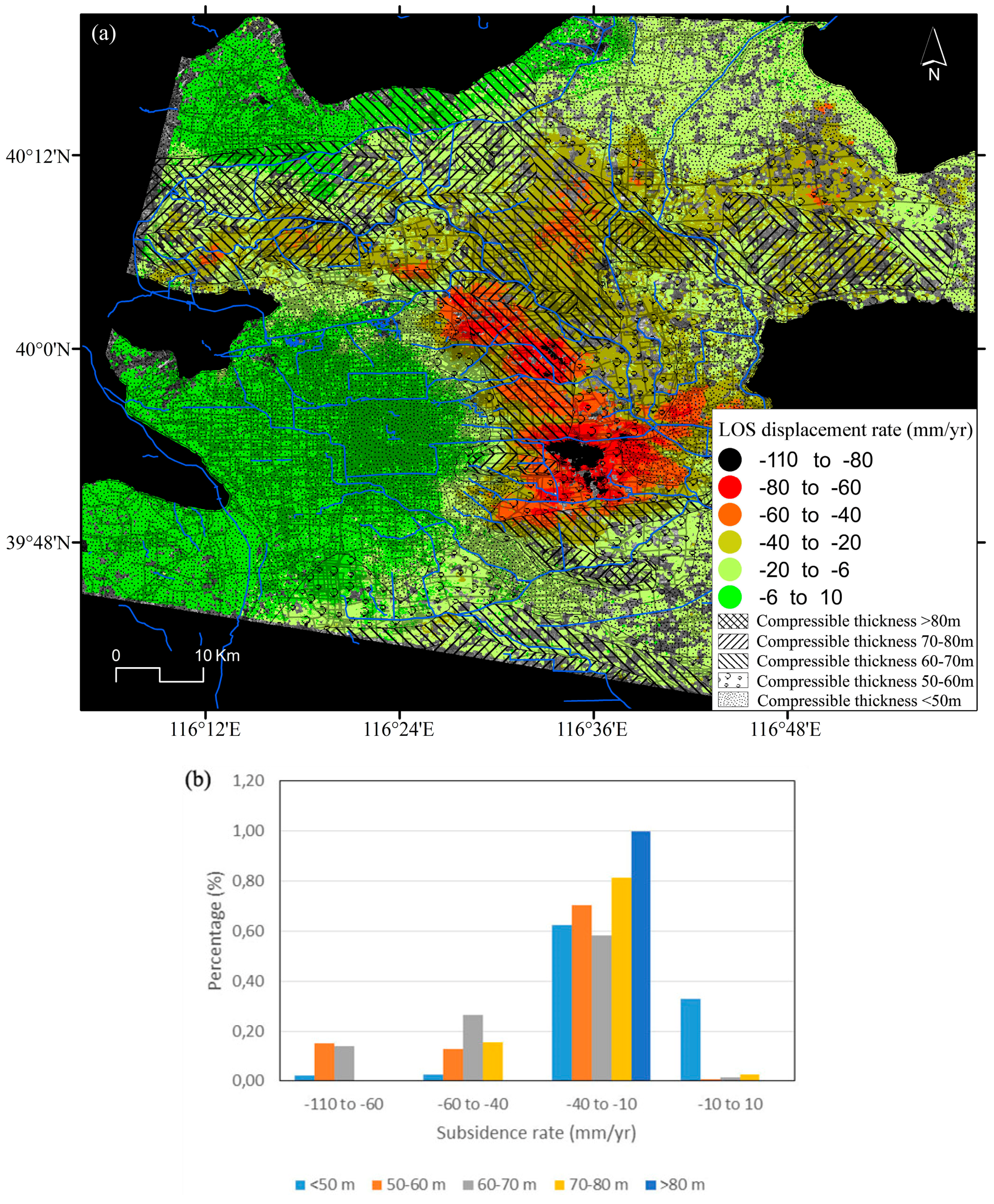
5.3. Relationships between Land Subsidence and Compressible Soil Thickness
5.4. Relationships between Land Subsidence and the Aquifer Structure
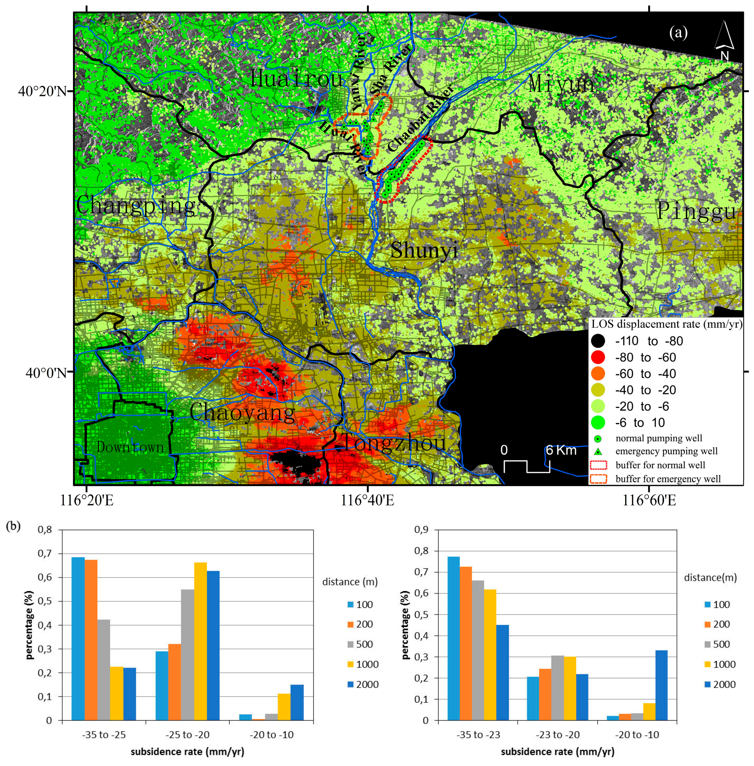
5.5. Relationships between Land Subsidence and Main Groundwater Extraction Areas
6. Conclusions
Acknowledgments
Author Contributions
Conflicts of Interest
References
- McDonald, R.I.; Weber, K.; Padowski, J.; Flörke, M.; Schneider, C.; Green, P.A.; Gleeson, T.; Eckman, S.; Lehner, B.; Balk, D.; et al. Water on an urban planet: Urbanization and the reach of urban water infrastructure. Glob. Environ. Chang. 2014, 27, 96–105. [Google Scholar] [CrossRef]
- Jia, S.; Wang, H.; Zhao, S.; Luo, Y. A tentative study of the mechanism of land subsidence in Beijing. City Geol. 2007, 2, 20–26. [Google Scholar]
- Xu, Y.; Shen, S.; Cai, Z.; Zhou, G. The state of land subsidence and prediction approaches due to groundwater withdrawal in china. Nat. Hazards 2008, 45, 123–135. [Google Scholar] [CrossRef]
- Ferretti, A.; Prati, C.; Rocca, F. Non-linear subsidence rate estimation using permanent scatterers in differential SAR interferometry. IEEE Trans. Geosci. Remote Sens. 2000, 38, 2202–2212. [Google Scholar] [CrossRef]
- Ferretti, A.; Prati, C.; Rocca, F. Permanent scatterers in SAR interferometry. IEEE Trans. Geosci. Remote Sens. 2001, 39, 8–20. [Google Scholar] [CrossRef]
- Berardino, P.; Fornaro, G.; Lanari, R.; Sansosti, E. A new algorithm for surface deformation monitoring based on small baseline differential SAR interferograms. IEEE Trans. Geosci. Remote Sens. 2002, 40, 2375–2383. [Google Scholar] [CrossRef]
- Mora, O.; Mallorqui, J.J.; Broquetas, A. Linear and nonlinear terrain deformation maps from a reduced set of interferometric SAR images. IEEE Trans. Geosci. Remote Sens. 2003, 41, 2243–2253. [Google Scholar] [CrossRef]
- Li, Z.; Fielding, E.J.; Cross, P. Integration of InSAR time-series analysis and water-vapor correction for mapping postseismic motion after the 2003 Bam (Iran) earthquake. IEEE Trans. Geosci. Remote Sens. 2009, 47, 3220–3230. [Google Scholar]
- Prati, C.; Ferretti, A.; Perissin, D. Recent advances on surface ground deformation measurement by means of repeated space-borne SAR observations. J. Geodyn. 2010, 49, 161–170. [Google Scholar] [CrossRef]
- Li, Z.; Pasquali, P.; Cantone, A.; Singleton, A.; Funning, G.; Forrest, D. MERIS atmospheric water vapor correction model for wide swath interferometric synthetic aperture radar. IEEE Geosci. Remote Sens. Lett. 2012, 9, 257–261. [Google Scholar] [CrossRef]
- Tomás, R.; Li, Z.; Liu, P.; Singleton, A.; Hoey, T.; Cheng, X. Spatiotemporal characteristics of the Huangtupo landslide in the Three Gorges region (China) constrained by radar interferometry. Geophys. J. Int. 2014, 197, 213–232. [Google Scholar] [CrossRef]
- Motagh, M.; Wetzel, H.; Roessner, S.; Kaufmann, H. A TerraSAR-X InSAR study of landslides in southern Kyrgyzstan, Central Asia. Remote Sens. Lett. 2013, 4, 657–666. [Google Scholar] [CrossRef]
- Gong, H.; Zhang, Y.; Li, X.; Lu, X.; Chen, B.; Gu, Z. Land subsidence research in Beijing based on the Permanent Scatterers InSAR technology. Prog. Nat. Sci. 2009, 19, 1261–1266. [Google Scholar]
- Li, Y.; Zhang, J.; Li, Z.; Luo, Y. Land subsidence in Beijing City from InSAR time series analysis with small baseline subset. Geomatics Inf. Sci. Wuhan Univ. 2013, 38, 1374–1377. [Google Scholar]
- Chen, B.; Gong, H.; Li, X.; Lei, K.; Zhang, Y.; Li, J.; Gu, Z.; Dang, Y. Spatial-temporal characteristics of land subsidence corresponding to dynamic groundwater funnel in Beijing municipality, China. Chin. Geogra. Sci. 2011, 21, 753–764. [Google Scholar] [CrossRef]
- Liang, F.; Sun, J.; Shen, Z.; Xu, X. Accumulated crustal deformation and its characteristics in Beijing and surrounding regions in 2007–2010 from L-band InSAR. Earthquake 2013, 33, 43–54. [Google Scholar]
- Ng, A. H.; Ge, L.; Li, X.; Zhang, K. Monitoring ground deformation in Beijing, China with persistent scatterer SAR interferometry. J. Geod. 2012, 86, 375–392. [Google Scholar] [CrossRef]
- Zhu, L.; Gong, H.; Li, X.; Li, Y.; Su, X.; Guo, G. Comprehensive analysis and artificial intelligent simulation of land subsidence of beijing, China. Chin. Geogra. Sci. 2013, 23, 237–248. [Google Scholar] [CrossRef]
- Hu, B.; Wang, H.; Sun, Y.; Hou, J.; Liang, J. Long-term land subsidence monitoring of Beijing (China) using the Small Baseline Subset (SBAS) technique. Remote Sens. 2014, 6, 3648–3661. [Google Scholar]
- Zhang, Y.; Gong, H.; Gu, Z.; Wang, R.; Li, X.; Zhao, W. Characterization of land subsidence induced by groundwater withdrawals in the plain of Beijing city, China. Hydrogeol. J. 2014, 22, 397–409. [Google Scholar] [CrossRef]
- Zhu, L.; Gong, H.; Li, X.; Wang, R.; Chen, B.; Dai, Z.; Teatini, P. Land subsidence due to groundwater withdrawal in the northern Beijing plain, China. Eng. Geol. 2015, 193, 243–255. [Google Scholar] [CrossRef]
- Wegmuller, U.; Walter, D.; Spreckels, V.; Werner, C.L. Nonuniform ground motion monitoring with TerraSAR-X persistent scatterer interferometry. IEEE Trans. Geosci. Remote Sens. 2010, 48, 895–904. [Google Scholar] [CrossRef]
- Liu, G.; Jia, H.; Zhang, R.; Zhang, H.; Jia, H.; Yu, B.; Sang, M. Exploration of Subsidence Estimation by persistent scatterer InSAR on time series of high resolution TerraSAR-X images. IEEE J. Sel. Topics Appl. Earth Observ. Remote Sens. 2011, 4, 159–170. [Google Scholar] [CrossRef]
- Chen, J.; Wu, J.; Zhang, L.; Zou, J.; Liu, G.; Zhang, R.; Yu, B. Deformation trend extraction based on multi-temporal InSAR in Shanghai. Remote Sens. 2013, 5, 1774–1786. [Google Scholar] [CrossRef]
- Luo, Q.; Perissin, D.; Zhang, Y.; Jia, Y. L- and X-band multi-temporal InSAR analysis of Tianjin subsidence. Remote Sens. 2014, 6, 7933–7951. [Google Scholar] [CrossRef]
- Swerts, E.; Denis, E. Megacities: The Asian Era. In Urban Development Challenges, Risks and Resilience in Asian Mega Cities; Singh, R.B., Ed.; Springer: Tokyo, Japan, 2015; pp. 1–28. [Google Scholar]
- Beijing Geology and Mineral Resources Exploration and Development Bureau; Hydrogeology and Engineering Geology Team of Beijing. Physical geography and regional geological settings. In Groundwater of Beijing; China Land Publishing House: Beijing, China, 2008; pp. 1–23. [Google Scholar]
- Beijing Geology and Mineral Resources Exploration and Development Bureau; Beijing Institute of Geology. Land subsidence. In Geological Hazard of Beijing; China Land Publishing House: Beijing, China, 2008; pp. 149–175. [Google Scholar]
- Liu, Y.; Ye, C.; Jia, S. Division of water-bearing zones and compressible layers in Beijing’s land subsidence areas. City Geol. 2007, 2, 10–15. [Google Scholar]
- Kampes, B.; Usai, S. Doris: The Delft object-oriented radar interferometric software. In Proceedings of the 2nd ITC ORS Symposium, Enschede, The Netherlands, 16–20 August 1999.
- Hooper, A. Persistent Scatterer Radar Interferometry for Crustal Deformation Studies and Modeling of Volcanic Deformation. Ph.D. Thesis, Stanford University, Stanford, CA, USA, 2006. [Google Scholar]
- Chen, C.W.; Zebker, H.A. Two-dimensional phase unwrapping with use of statistical models for cost functions in nonlinear optimization. J. Opt. Soc. Am. A 2001, 18, 338–351. [Google Scholar] [CrossRef]
- Hooper, A.; Zebker, H.A. Phase unwrapping in three dimensions with application to InSAR time series. J. Opt. Soc. Am. A 2007, 24, 2737–2747. [Google Scholar] [CrossRef]
- Schmidt, D.A.; Bürgmann, R. Time-dependent land uplift and subsidence in the Santa Clara valley, California, from a large interferometric synthetic aperture radar data set. J. Geophys. Res. 2003, 108. [Google Scholar] [CrossRef]
- Fialko, Y.; Simons, M.; Agnew, D. The complete (3-D) surface displacement field in the epicentral area of the 1999 Mw7.1 hector mine earthquake, California, from space geodetic observations. Geophys. Res. Lett. 2001, 28, 3063–3066. [Google Scholar] [CrossRef]
- Terzaghi, K. Settlement and consolidation of clay. Eng. News Rec. 1925, 95, 874–878. [Google Scholar]
- Galloway, D.L.; Jones, D.R.; Ingebritsen, S.E. Land Subsidence in the United States: U.S. Geological Survey Circular 1182; U.S. Geological Survey: Reston, Virginia, USA, 1999; p. 177.
- Riley, F.S. Analysis of borehole extensometer data from central California. Land Subsid. 1969, 2, 423–431. [Google Scholar]
- Helm, D.C. One-dimensional simulation of aquifer system compaction near Pixley, California: 1. Constant parameters. Water Resour. Res. 1975, 11, 465–478. [Google Scholar] [CrossRef]
- Yang, Y.; Luo, Y.; Liu, M.; Wang, R.; Wang, H. Research of features related to land subsidence and ground fissure disasters in the Beijing plain. In Proceedings of the International Association of Hydrological Sciences, Nagoya, Japan, 15–19 November 2015; pp. 239–242.
- Beijing Geology and Mineral Resources Exploration and Development Bureau; Beijing Institute of Geological Survey. Condition of geological tectonics and estimation of stability. In City Geology of Beijing; China Land Publishing House: Beijing, China, 2008; pp. 24–33. [Google Scholar]
- Zhang, L.; Bai, L.; Cai, X.; Wang, J.; Liu, Y.; He, F.; Wang, Z.; He, J. An analysis of the activity of the northwest part of Nankou-Sunhe fault. Geol. China 2014, 41, 902–911. [Google Scholar]
- Zhang, L.; Bai, L.; Cai, X.; Wang, J.; Liu, Y.; Guo, G.; Yang, T.; Wu, H.; He, J.; Zhao, Y. Magnetostratigraphy study on the south segment of Nankou-Sunhe fault at Beijing plain and its implications for the fault activity during quaternary. Quat. Sci. 2014, 34, 381–390. [Google Scholar]
- Jiang, W.; Hou, Z.; Xie, X. Research on paleoearthquakes in Jiuxian trenches across Nankou-Sunhe fault zone in Changping County of Beijing plain. Sci. China Ser. D-Earth Sci. 2002, 45, 160–173. [Google Scholar] [CrossRef]
- Zhang, S.; Wang, D.; Liu, X.; Zhang, G.; Zhao, J.; Luo, M.; Ren, J.; Wang, R.; Zhang, Y. Using borehole core analysis to reveal Late Quaternary paleoearthquakes along the Nankou-Sunhe Fault, Beijing. Sci. China Ser. D-Earth Sci. 2008, 51, 1154–1168. [Google Scholar] [CrossRef]
- Gao, Z.; Chen, Q.; Huang, J.; Qi, C.; Li, H. Velocity Structure Beneath Active Faults and Seismic Tectonic Characteristics in the Beijing Area. Res. Earthquake China 2011, 25, 59–69. [Google Scholar]
- Tomás, R.; Herrera, G.; Lopez-Sanchez, J.M.; Vicente, F.; Cuenca, A.; Mallorquí, J.J. Study of the land subsidence in Orihuela city (SE Spain) using PSI data: Distribution, evolution and correlation with conditioning and triggering factors. Eng. Geol. 2010, 115, 105–121. [Google Scholar] [CrossRef]
- Tomás, R.; Herrera, G.; Cooksley, G.; Mulas, J. Persistent scatterer interferometry subsidence data exploitation using spatial tools: The vega media of the Segura river basin case study. J. Hydrol. 2011, 400, 411–428. [Google Scholar] [CrossRef]


© 2016 by the authors; licensee MDPI, Basel, Switzerland. This article is an open access article distributed under the terms and conditions of the Creative Commons Attribution (CC-BY) license (http://creativecommons.org/licenses/by/4.0/).
Share and Cite
Chen, M.; Tomás, R.; Li, Z.; Motagh, M.; Li, T.; Hu, L.; Gong, H.; Li, X.; Yu, J.; Gong, X. Imaging Land Subsidence Induced by Groundwater Extraction in Beijing (China) Using Satellite Radar Interferometry. Remote Sens. 2016, 8, 468. https://doi.org/10.3390/rs8060468
Chen M, Tomás R, Li Z, Motagh M, Li T, Hu L, Gong H, Li X, Yu J, Gong X. Imaging Land Subsidence Induced by Groundwater Extraction in Beijing (China) Using Satellite Radar Interferometry. Remote Sensing. 2016; 8(6):468. https://doi.org/10.3390/rs8060468
Chicago/Turabian StyleChen, Mi, Roberto Tomás, Zhenhong Li, Mahdi Motagh, Tao Li, Leyin Hu, Huili Gong, Xiaojuan Li, Jun Yu, and Xulong Gong. 2016. "Imaging Land Subsidence Induced by Groundwater Extraction in Beijing (China) Using Satellite Radar Interferometry" Remote Sensing 8, no. 6: 468. https://doi.org/10.3390/rs8060468
APA StyleChen, M., Tomás, R., Li, Z., Motagh, M., Li, T., Hu, L., Gong, H., Li, X., Yu, J., & Gong, X. (2016). Imaging Land Subsidence Induced by Groundwater Extraction in Beijing (China) Using Satellite Radar Interferometry. Remote Sensing, 8(6), 468. https://doi.org/10.3390/rs8060468