
Ash Decline Assessment in Emerald Ash Borer Infested Natural Forests Using High Spatial Resolution Images


Abstract
:
1. Introduction
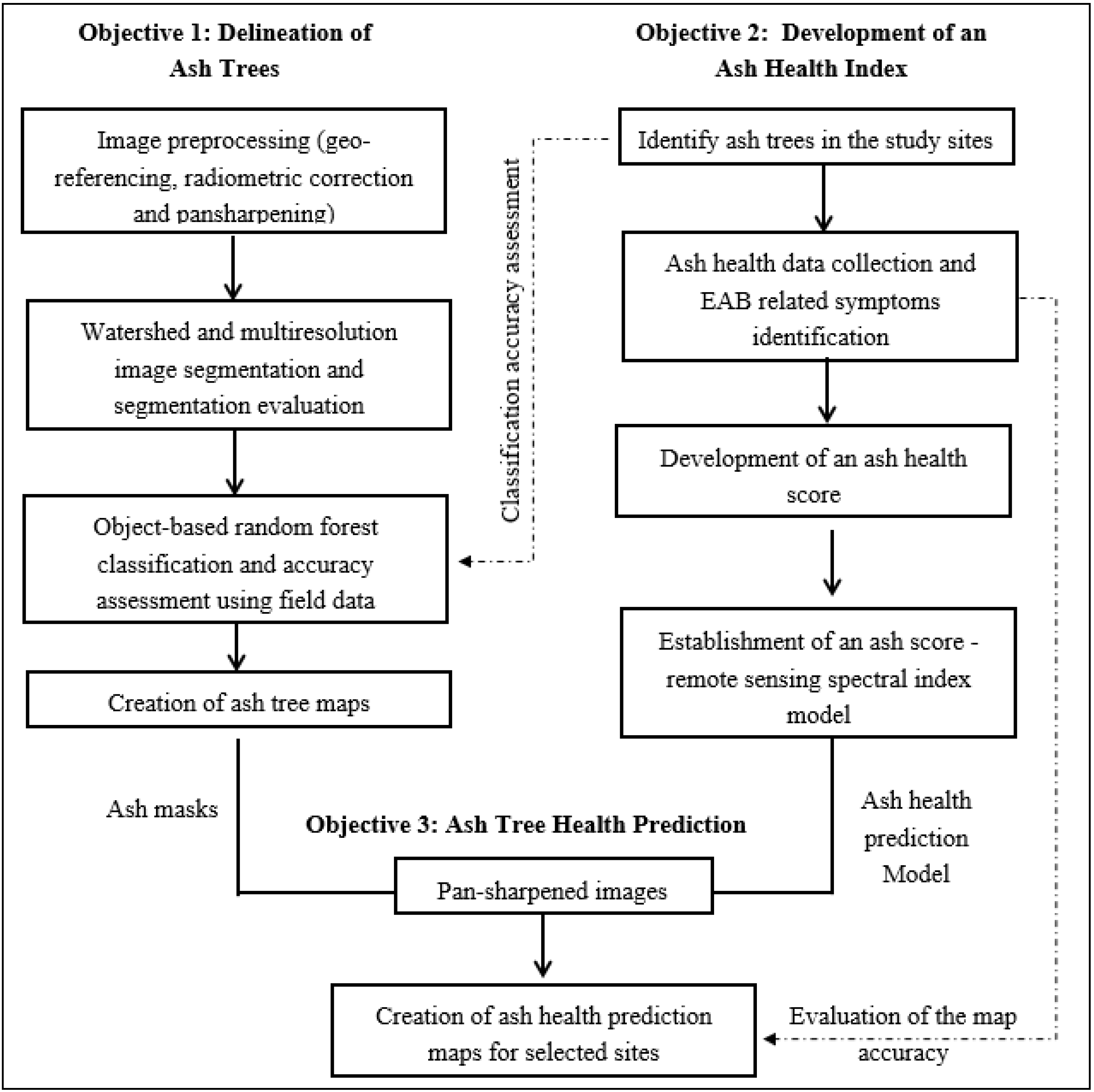
2. Data and Methods
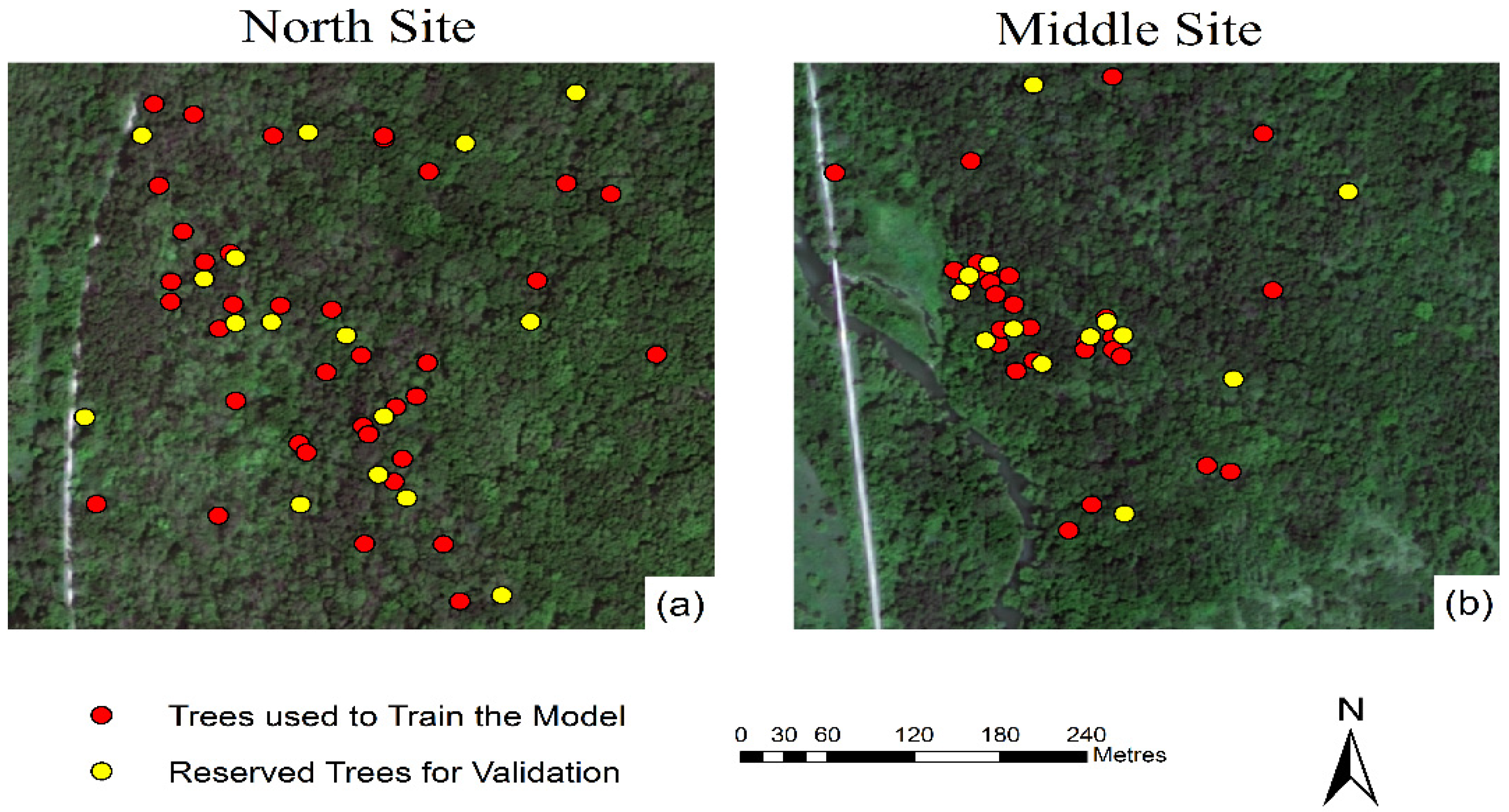
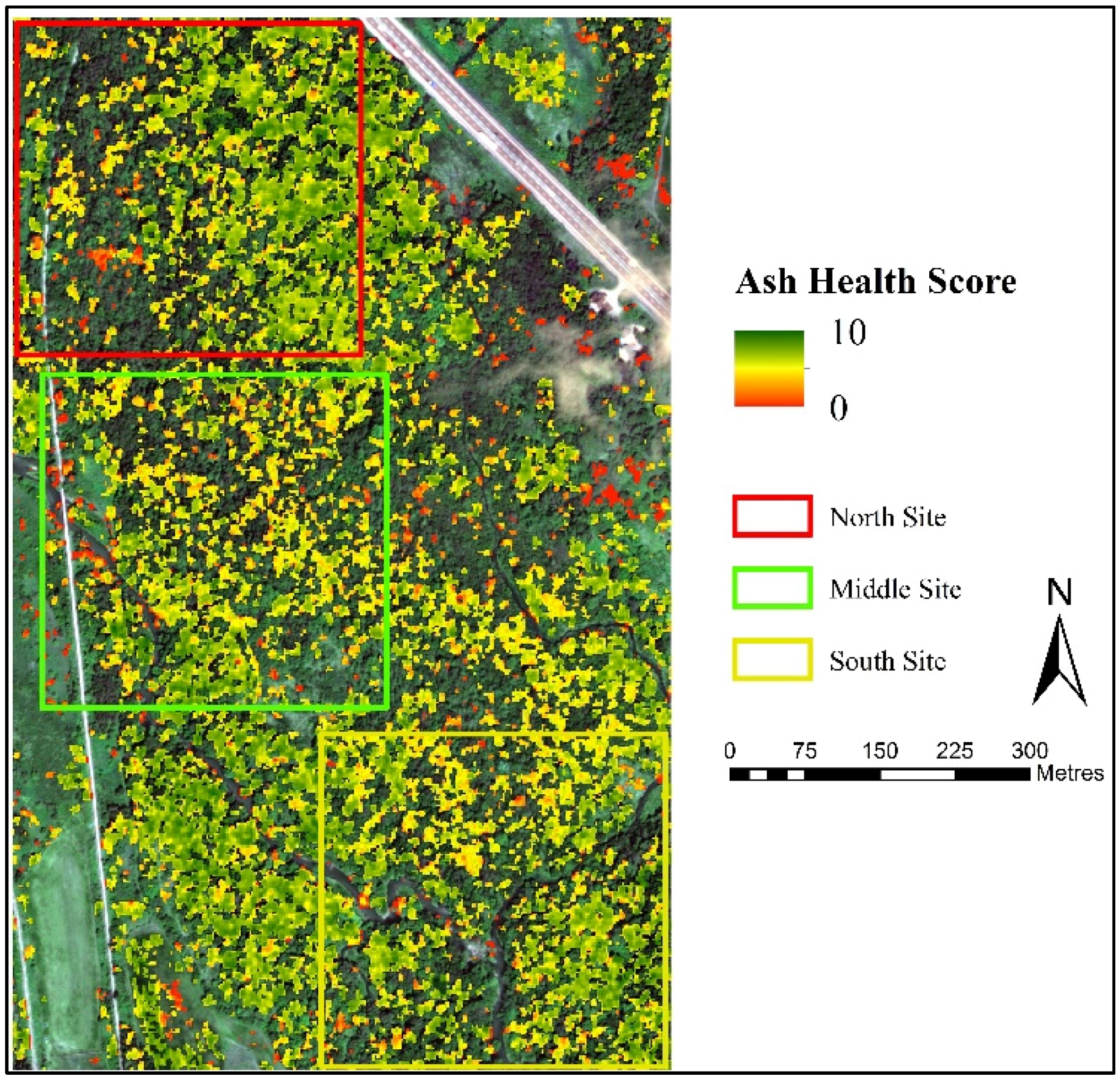
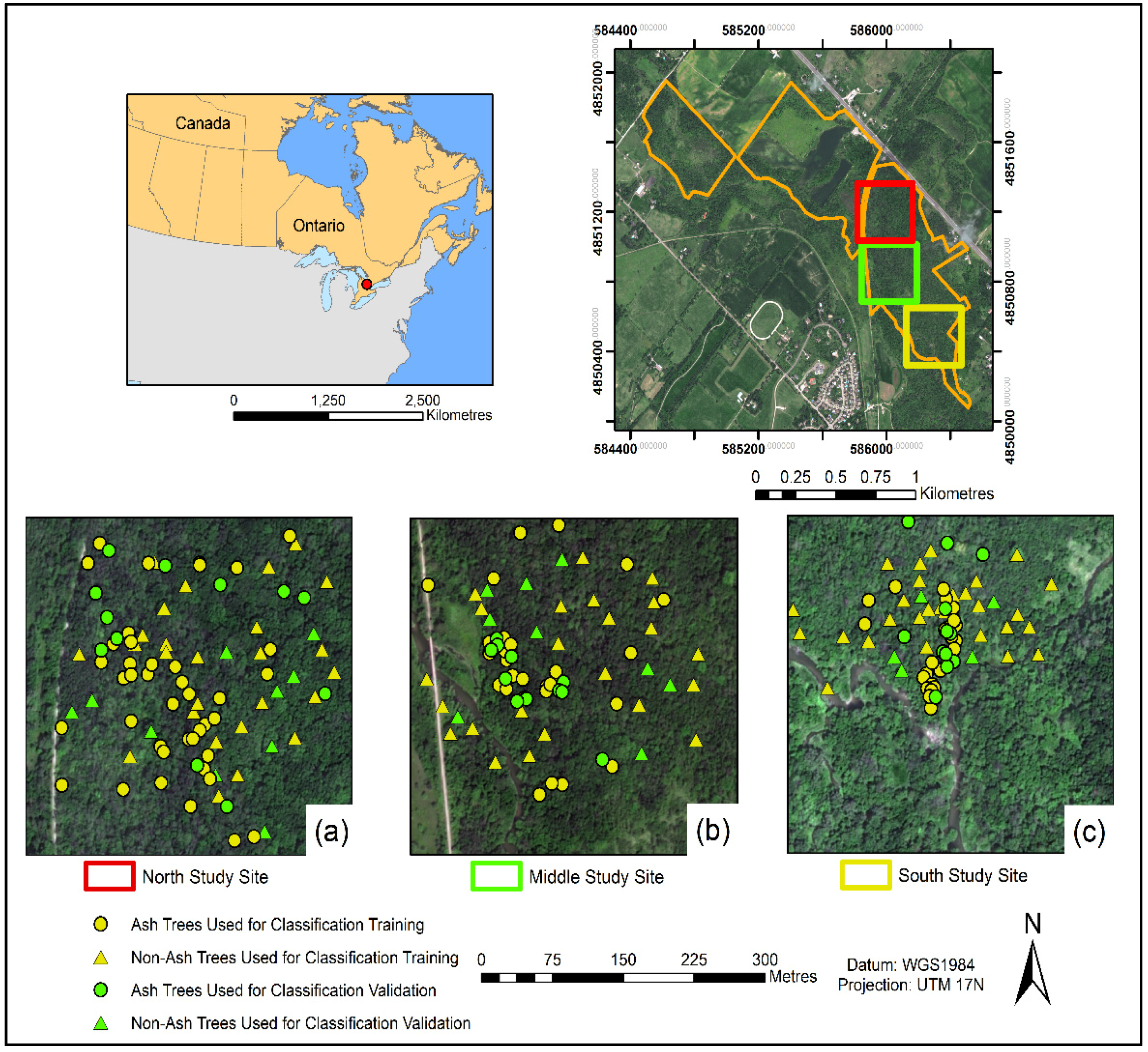
2.1. Study Area and Study Sites
2.2. Study Data
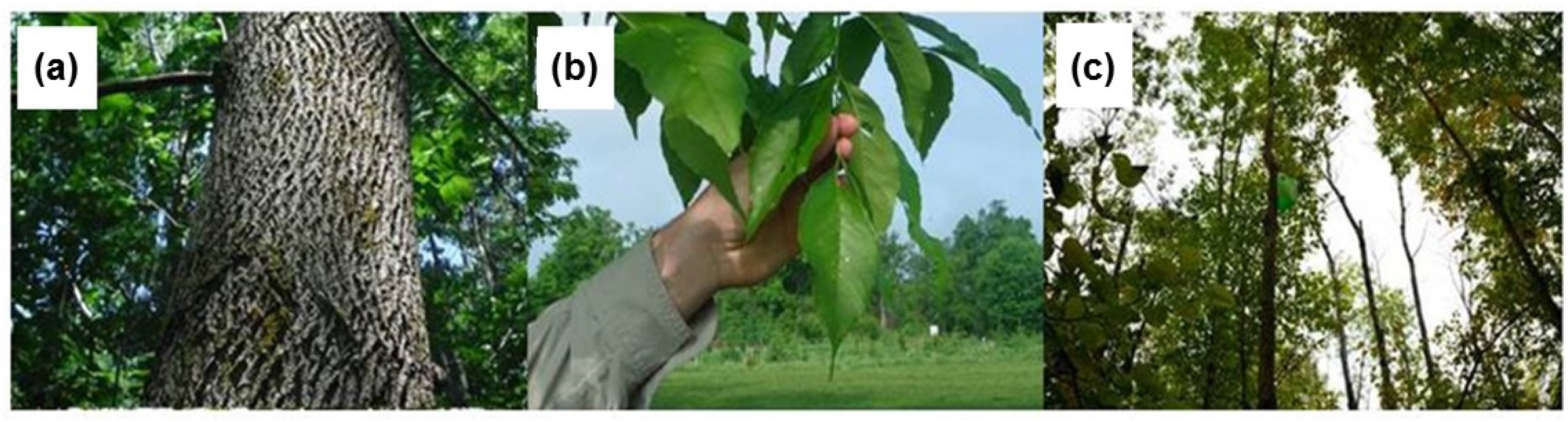
2.2.1. Field Data
2.2.2. Development of an Ash Health Score Based on Field Observations
2.2.3. Image Data
2.3. Methods
2.3.1. Image Segmentation and Classification
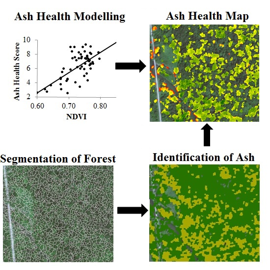
2.3.2. Establishing the Ash Health Prediction Model and Mapping the EAB Infestation
3. Results and Discussion
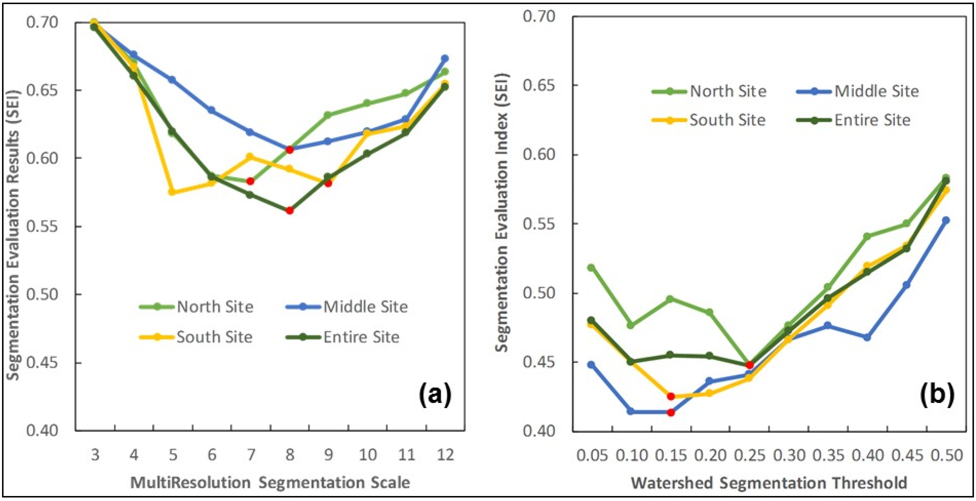
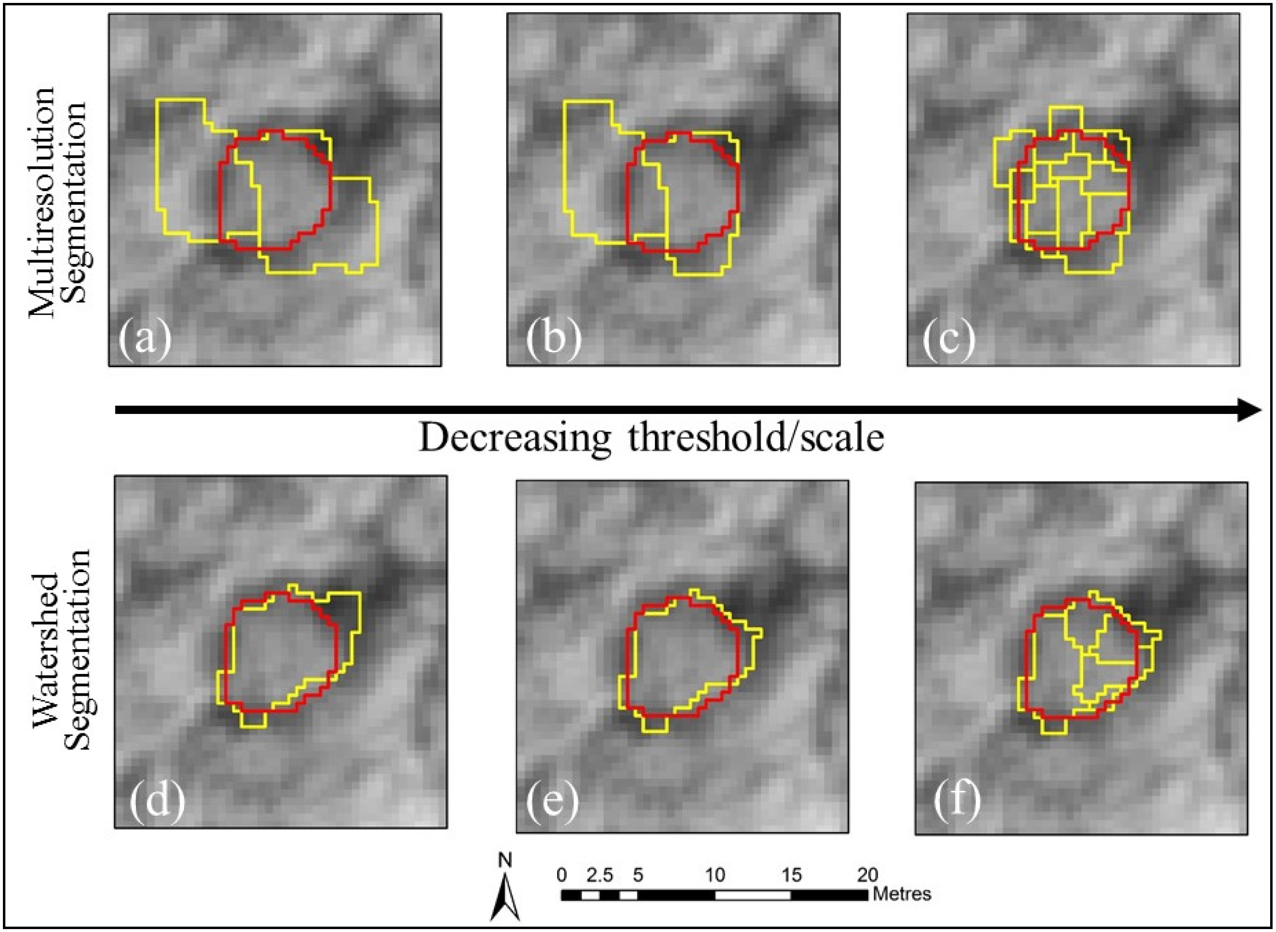
3.1. Segmentation Results
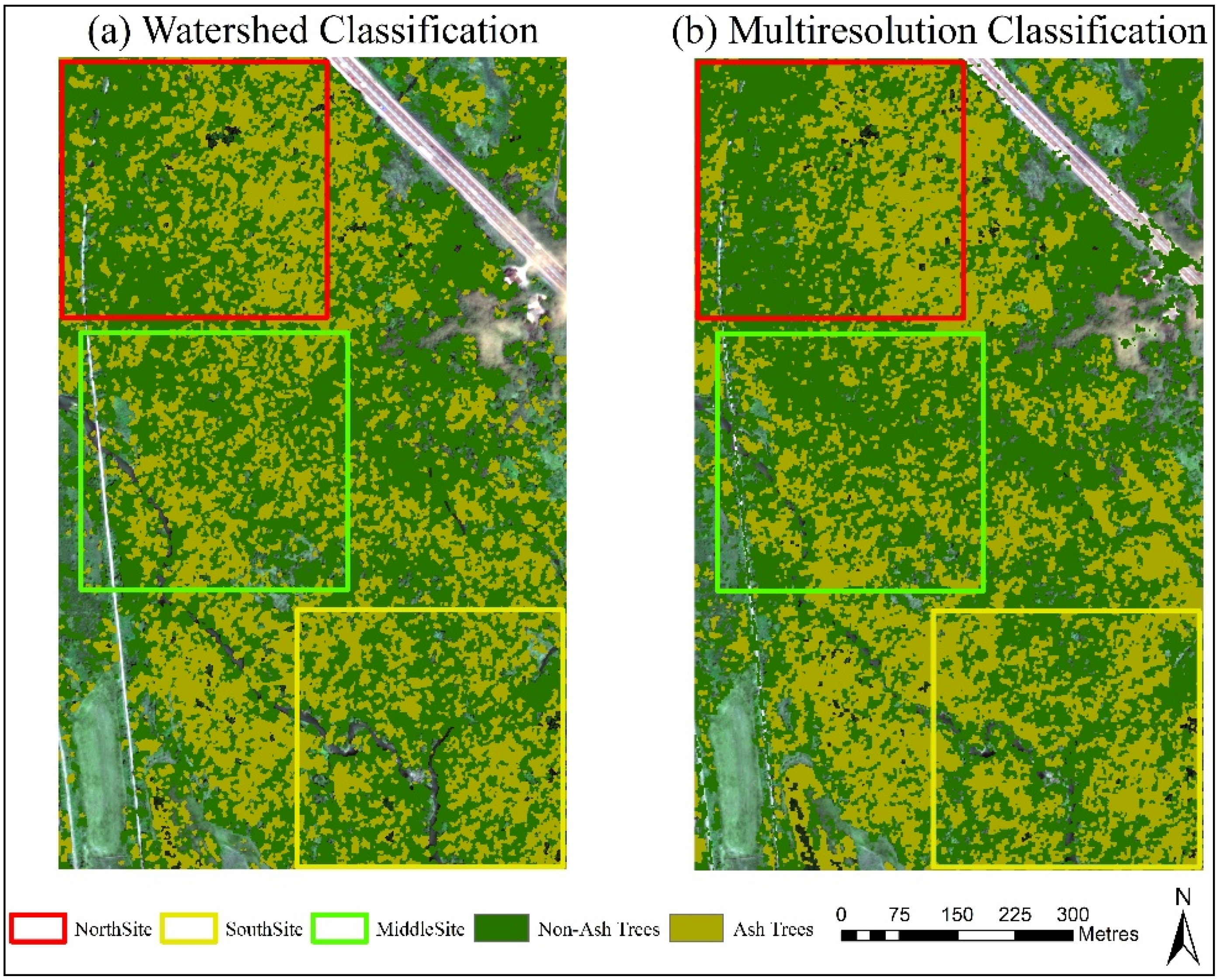
3.2. Classification Results
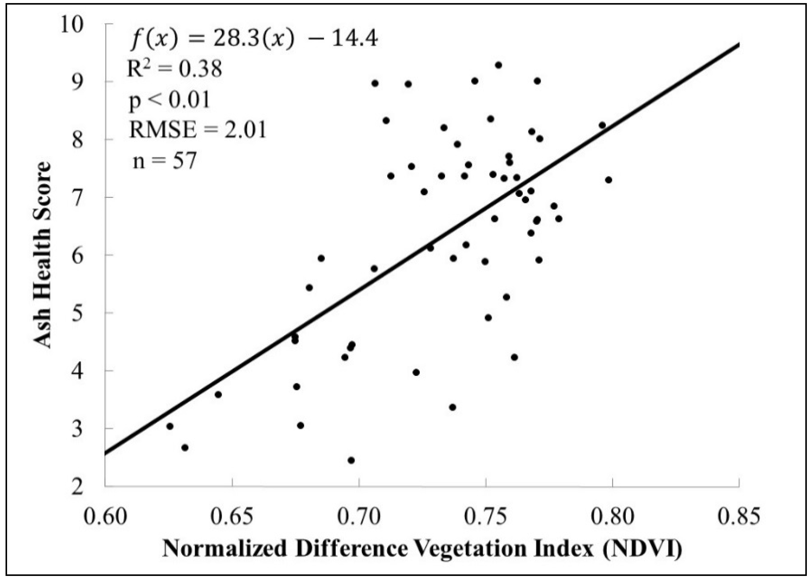
3.3. Ash Health Prediction
4. Conclusions and Future Work
Acknowledgments
Author Contributions
Conflicts of Interest
Abbreviations
| UA | User’s Accuracy |
| PA | Producer’s Accuracy |
| EAB | Emerald Ash Borer |
| SEI | Segmentation Evaluation Index |
| WV2 | WorldView-2 |
| MA | Map Accuracy |
| NDVI | Normalized Difference Vegetation Index |
| GNDVI | Green Normalized Difference Vegetation Index |
| EVI | Enhanced Vegetation Index |
| IPVI | Infrared Percentage Vegetation Index |
| DVI | Difference Vegetation Index |
| RVI | Ratio Vegetation Index |
| RDVI | Renormalized Difference Vegetation Index |
| UAV | Unmanned Aerial Vehicle |
| RMSE | Root Mean Square Error |
| SVM | Support Vector Machine |
| GEOBIA | Geographic Object-Based Image Analysis |
| SAGA | System for Automated Geoscientific Analyses |
| ATCOR | Atmospheric and Topographic Correction |
References
- Agnecy, C.F.I. RMD-13-01: Regulated Areas for Emerald Ash Borer (EAB) (Agrilus planipennis Fairmaire); Canadian Food Inspection Agency: Ottawa, ON, Canada, 2014. [Google Scholar]
- Herms, D.A.; Gandhi, K.J.; Smith, A.; Cardina, J.; Knight, K.S.; Herms, C.P.; Long, R.P.; McCullough, D.G. Ecological impacts of emerald ash borer in forests of southeast Michigan. In Proceedings of the 20th U.S. Department of Agriculture Interagency Research Forum on Invasive Species, Annapolis, MD, USA, 13–16 January 2009; McManus, K.A., Gottschalk, K.W., Eds.; U.S. Department of Agriculture, Forest Service, Northern Research Station: Newtown, PA, USA, 2009; pp. 36–37. [Google Scholar]
- Cipollini, D.; Wang, Q.; Whitehill, J.G.A.; Powell, J.R.; Bonello, P.; Herms, D.A. Distinguishing defensive characteristics in the phloem of ash species resistant and susceptible to emerald ash borer. J. Chem. Ecol. 2011, 37, 450–459. [Google Scholar] [CrossRef] [PubMed]
- Colautti, R.I.; Bailey, S.A.; Van Overdijk, C.D.A.; Amundsen, K.; MacIsaac, H.J. Characterised and projected costs of nonindigenous species in Canada. Biol. Invasions 2006, 8, 45–59. [Google Scholar] [CrossRef]
- Poland, T.M.; McCullough, D.G. Emerald ash borer: Invasion of the urban forest and the threat to North America’s ash resource. J. For. 2006, 104, 118–124. [Google Scholar]
- Smitley, D.; Davis, T.; Rebek, E. Progression of ash canopy thinning and dieback outward from the initial infestation of emerald ash borer (Coleoptera: Buprestidae) in southeastern Michigan. J. Econ. Entomol. 2008, 101, 1643–1650. [Google Scholar] [CrossRef] [PubMed]
- Herms, D.A.; McCullough, D.G. Emerald ash borer invasion of North America: History, biology, ecology, impacts, and management. Annu. Rev. Entomol. 2014, 59, 13–30. [Google Scholar] [CrossRef] [PubMed]
- Siegert, N.W.; McCullough, D.G.; Liebhold, A.M.; Telewski, F.W. Spread and dispersal of emerald ash borer: A dendrochronological approach. In Proceedings of the Emerald Ash Borer Research and Technology Development Meeting, Pittsburgh, PA, USA, 26–27 September 2010; p. 10.
- McKenzie, N.; Helson, B.; Thompson, D.; Otis, G.; McFarlane, J.; Buscarini, T.; Meating, J. Azadirachtin: An effective systemic insecticide for control of Agrilus planipennis (Coleoptera: Buprestidae). J. Econ. Entomol. 2010, 103, 708–717. [Google Scholar] [CrossRef] [PubMed]
- Hay, G.J.; Castilla, G. Geographic Object-Based Image Analysis (GEOBIA): A new name for a new discipline. In Object-Based Image Analysis; Springer: Berlin, Germany; Heidelberg, Germany, 2008; pp. 75–89. [Google Scholar]
- Yang, J.; He, Y.; Weng, Q. An automated method to parameterize segmentation scale by enhancing intrasegment homogeneity and intersegment heterogeneity. IEEE Geosci. Remote Sens. Lett. 2015, 12, 1282–1286. [Google Scholar] [CrossRef]
- Yang, J.; He, Y.; Caspersen, J. A multi-band watershed segmentation method for individual tree crown delineation from high resolution multispectral aerial image. In Proceedings of the IEEE International Geoscience and Remote Sensing System, Quebec City, QC, Canada, 13–18 July 2014; pp. 1588–1591.
- Benz, U.C.; Hofmann, P.; Willhauck, G.; Lingenfelder, I.; Heynen, M. Multi-resolution, object-oriented fuzzy analysis of remote sensing data for GIS-ready information. ISPRS J. Photogramm. Remote Sens. 2004, 58, 239–258. [Google Scholar] [CrossRef]
- Zhang, H.; Fritts, J.E.; Goldman, S.A. Image segmentation evaluation: A survey of unsupervised methods. Comput. Vis. Image Underst. 2008, 110, 260–280. [Google Scholar] [CrossRef]
- Yang, J.; Li, P.; He, Y. A multi-band approach to unsupervised scale parameter selection for multi-scale image segmentation. ISPRS J. Photogramm. Remote Sens. 2014, 94, 13–24. [Google Scholar] [CrossRef]
- Yang, J.; He, Y.; Caspersen, J.; Jones, T. A discrepancy measure for segmentation evaluation from the perspective of object recognition. ISPRS J. Photogramm. Remote Sens. 2015, 101, 186–192. [Google Scholar] [CrossRef]
- Myint, S.W.; Gober, P.; Brazel, A.; Grossman-Clarke, S.; Weng, Q. Per-pixel vs. object-based classification of urban land cover extraction using high spatial resolution imagery. Remote Sens. Environ. 2011, 115, 1145–1161. [Google Scholar] [CrossRef]
- Huang, C.; Davis, L.S.; Townshend, J.R.G. An assessment of support vector machines for land cover classification. Int. J. Remote Sens. 2002, 23, 725–749. [Google Scholar] [CrossRef]
- Mountrakis, G.; Im, J.; Ogole, C. Support vector machines in remote sensing: A review. ISPRS J. Photogramm. Remote Sens. 2011, 66, 247–259. [Google Scholar] [CrossRef]
- Roli, F.; Fumera, G. Support vector machines for remote sensing image classification. Proc. SPIE 2001, 4170, 160–166. [Google Scholar]
- Duda, R.O.; Hart, P.E.; Stork, D.G. Pattern Classification, 2nd ed.; John Wiley & Sons, Inc.: New York, NY, USA, 2001. [Google Scholar]
- Carter, G.A. Responses of leaf spectral reflectance to plant stress. Am. J. Bot. 1993, 80, 239–243. [Google Scholar] [CrossRef]
- Carter, G.A. Ratios of leaf reflectances in narrow wavebands as indicators of plant stress. Int. J. Remote Sens. 1994, 15, 697–703. [Google Scholar] [CrossRef]
- Bourque, D.P.; Naylor, A.W. Large effects of small water deficits on chlorophyll accumulation and ribonucleic acid synthesis in etiolated leaves of jack bean (Canavalia ensiformis [L.] DC.). Plant Physiol. 1971, 47, 591–594. [Google Scholar] [CrossRef] [PubMed]
- Pontius, J.; Martin, M.; Plourde, L.; Hallett, R. Ash decline assessment in emerald ash borer-infested regions: A test of tree-level, hyperspectral technologies. Remote Sens. Environ. 2008, 112, 2665–2676. [Google Scholar] [CrossRef]
- Zhang, K.; Hu, B.; Hanou, I.; Jin, L. Early detecting ash Emerald Ash Borer (EAB) infestation using Hyperspectral imagery. In Proceedings of the IEEE International Geoscience and Remote Sensing Symposium, Munich, Germany, 22–27 July 2012; pp. 6360–6363.
- Waser, L.T.; Küchler, M.; Jütte, K.; Stampfer, T. Evaluating the potential of worldview-2 data to classify tree species and different levels of ash mortality. Remote Sens. 2014, 6, 4515–4545. [Google Scholar] [CrossRef]
- Schomaker, M.E.; Zarnoch, S.J.; Bechtold, W.A.; Latelle, D.J.; Burkman, W.G.; Cox, S.M. Crown-Condition Classification: A Guide to Data Collection and Analysis; General Technical Report SRS-102; U.S. Department of Agriculture, Forest Service, Southern Research Station: Asheville, NC, USA, 2007.
- Bendor, T.K.; Metcalf, S.S.; Fontenot, L.E.; Sangunett, B.; Hannon, B. Modeling the spread of the Emerald Ash Borer. Ecol. Model. 2006, 7, 221–236. [Google Scholar] [CrossRef]
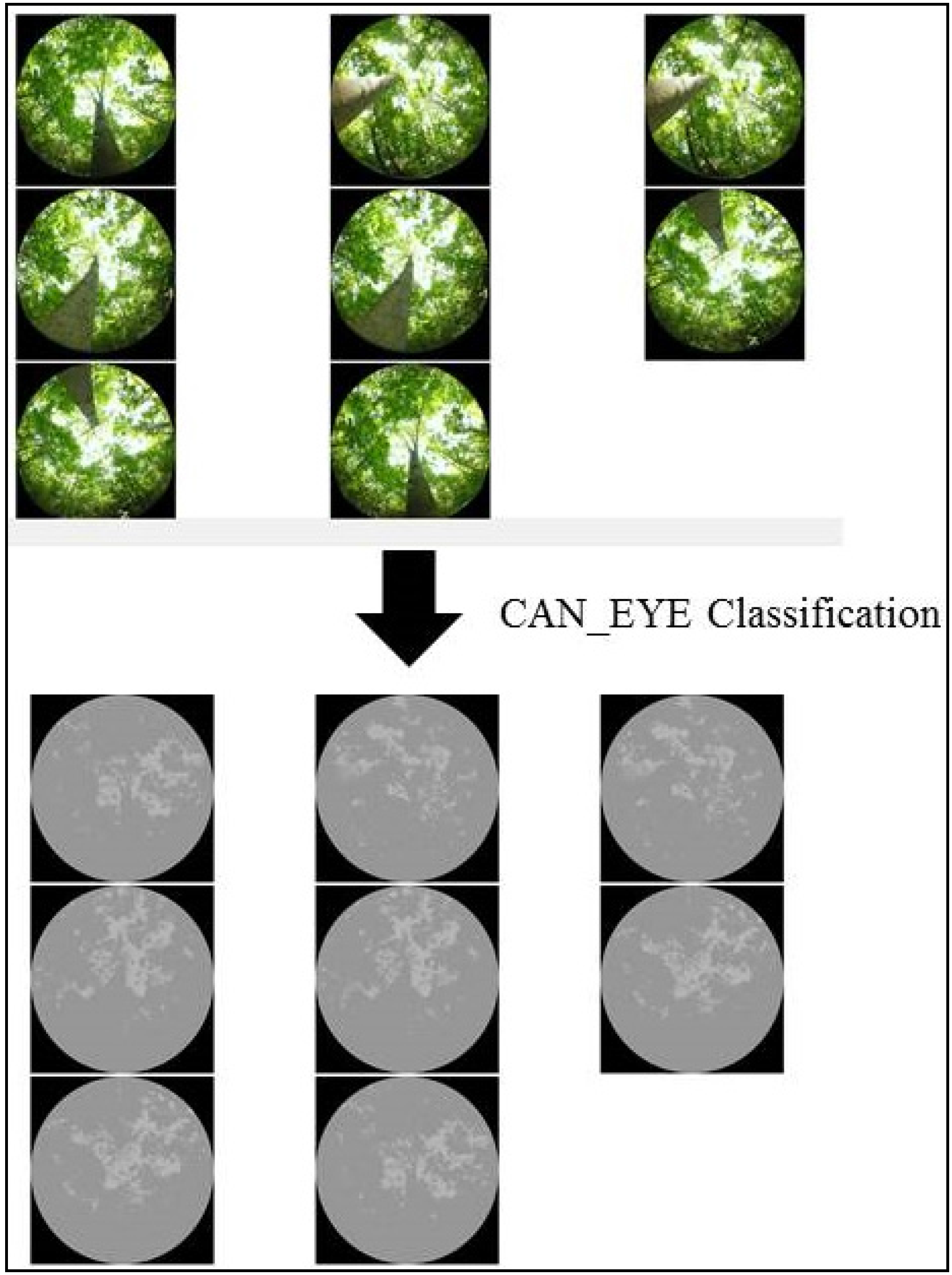
- Jennings, S.B.; Brown, N.D.; Sheil, D. Assessing forest canopies and understorey illumination: Canopy closure, canopy cover and other measures. Forestry 1999, 72, 59–73. [Google Scholar] [CrossRef]
- Demarez, V.; Duthoit, S.; Baret, F.; Weiss, M.; Dedieu, G. Estimation of leaf area and clumping indexes of crops with hemispherical photographs. Agric. For. Meteorol. 2008, 148, 644–655. [Google Scholar] [CrossRef]
- Rossini, M.; Panigada, C.; Meroni, M.; Colombo, R. Assessment of oak forest condition based on leaf biochemical variables and chlorophyll fluorescence. Tree Physiol. 2006, 26, 1487–1496. [Google Scholar] [CrossRef] [PubMed]
- Laben, C.A.; Brower, B.V. Process for Enhancing the Spatial Resolution of Multispectral Imagery Using Pansharpening. U.S. Patent 611875, 4 January 2000. [Google Scholar]
- Li, C.; Liu, L.; Wang, J.; Zhao, C.; Wang, R. Comparison of two methods of the fusion of remote sensing images with fidelity of spectral information. In Proceedings of the IEEE International Geoscience and Remote Sensing Symposium, Anchorage, AK, USA, 20–24 September 2004; pp. 2561–2564.
- Blaschke, T.; Geoffrey, J. Obect-oriented image analysis and scale-space: Theory and methods and evaluating multiscale lanscape structure. Int. Arch. Photogramm. Remote Sens. 2001, 34, 22–29. [Google Scholar]
- Conrad, O.; Bechtel, B.; Bock, M.; Dietrich, H.; Fischer, E.; Gerlitz, L.; Wehberg, J.; Wichmann, V.; Böhner, J. System for Automated Geoscientific Analyses (SAGA) v. 2.1.4. Geosci. Model Dev. Discuss. 2015, 8, 2271–2312. [Google Scholar] [CrossRef]
- Definiens AG. Definiens Developer 7 User Guide; Definiens AG: Munchen, Germany, 2009. [Google Scholar]
- Jackson, R.D.; Huete, A.R. Interpreting vegetation indices. Prev. Vet. Med. 1991, 11, 185–200. [Google Scholar] [CrossRef]
- Ahamed, T.; Tian, L.; Zhang, Y.; Ting, K.C. A review of remote sensing methods for biomass feedstock production. Biomass Bioenergy 2011, 35, 2455–2469. [Google Scholar] [CrossRef]
- Huete, A.; Didan, K.; Miura, T.; Rodriguez, E.P.; Gao, X.; Ferreira, L.G. Overview of the radiometric and biophysical performance of the MODIS vegetation indices. Remote Sens. Environ. 2002, 83, 195–213. [Google Scholar] [CrossRef]
- Crippen, R.E. Calculating the vegetation index faster. Remote Sens. Environ. 1990, 73, 71–73. [Google Scholar] [CrossRef]
- Tucker, C.J. Red and photographic infrared linear combinations for monitoring vegetation. Remote Sens. Environ. 1979, 150, 127–150. [Google Scholar] [CrossRef]
- Jordan, C.F. Derivation of leaf-area index from quality of light on the forest floor. Ecology 1969, 50, 663–666. [Google Scholar] [CrossRef]
- Roujean, J.L.; Breon, F.M. Estimating PAR absorbed by vegetation from bidirectional reflectance measurements. Remote Sens. Environ. 1995, 51, 375–384. [Google Scholar] [CrossRef]
- Baugh, W.M.; Groeneveld, D.P. Broadband vegetation index performance evaluated for a low-cover environment. Int. J. Remote Sens. 2006, 27, 4715–4730. [Google Scholar] [CrossRef]
- Team, R.C. R: A Language and Environmnet for Statistical Computing; R Foundation for Statistical Computing: Vienna, Austria, 2013. [Google Scholar]
- Pu, R.; Gong, P. Wavelet transform applied to EO-1 hyperspectral data for forest LAI and crown closure mapping. Remote Sens. Environ. 2004, 91, 212–224. [Google Scholar] [CrossRef]
- Latif, Z.A.; Zamri, I.; Omar, H. Determination of tree species using Worldview-2 data. In Proceedings of the IEEE 8th International Colloquium on Signal Processing and its Applications, Malacca, Malaysia, 23–25 March 2012; pp. 383–387.
- Katoh, M. Classifying tree species in a northern mixed forest using high-resolution IKONOS data. J. For. Res. 2004, 9, 7–14. [Google Scholar] [CrossRef]
- Immitzer, M.; Atzberger, C.; Koukal, T. Tree species classification with random forest using very high spatial resolution 8-band WorldView-2 satellite data. Remote Sens. 2012, 4, 2661–2693. [Google Scholar] [CrossRef]
- Doody, T.M.; Lewis, M.; Benyon, R.G.; Byrne, G. A method to map riparian exotic vegetation (Salix spp.) area to inform water resource management. Hydrol. Process. 2014, 28, 3809–3823. [Google Scholar] [CrossRef]
- Omer, G.; Mutanga, O.; Abdel-Rahman, E.M.; Adam, E. Performance of support vector machines and artifical neural network for mapping endangered tree species using WorldView-2 data in Dukuduku Forest, South Africa. IEEE J. Sel. Top. Appl. Earth Obs. Remote Sens. 2015, 8, 4825–4840. [Google Scholar] [CrossRef]
- Dalponte, M.; Ørka, H.O.; Gobakken, T.; Gianelle, D.; Næsset, E. Tree species classification in boreal forests with hyperspectral data. IEEE Trans. Geosci. Remote Sens. 2013, 51, 2632–2645. [Google Scholar] [CrossRef]
- Pu, R.; Landry, S. A comparative analysis of high spatial resolution IKONOS and WorldView-2 imagery for mapping urban tree species. Remote Sens. Environ. 2012, 124, 516–533. [Google Scholar] [CrossRef]
- Oumar, Z.; Mutanga, O. Integrating environmental variables and WorldView-2 image data to improve the prediction and mapping of Thaumastocoris peregrinus (bronze bug) damage in plantation forests. ISPRS J. Photogramm. Remote Sens. 2014, 87, 39–46. [Google Scholar] [CrossRef]
- Immitzer, M.; Atzberger, C. Early detection of bark beetle infestation in Norway spruce (Picea abies, L.) using WorldView-2 data. Photogramm. Fernerkundung Geoinform. 2014, 2014, 351–367. [Google Scholar] [CrossRef]
- Chávez, R.O.; Clevers, J.G.P.W. Object-Based Analysis of 8-Bands Worldview2 Imagery for Assessing Health Condition of Desert Trees; Wageningen University: Wageningen, The Netherlands, 2012. [Google Scholar]
- Filchev, L. An assessment of european spruce bark beetle infestation using WorldView-2 Satellite data. In Proceedings of the 1st European SCGIS Conference with International Participation “Best Practices: Application of GIS Technologies for Conservation of Natural and Cultural Heritage Sites”, Sofia, Bulgaria, 21–23 May 2012; pp. 21–23.
- Chapin, F.S. Integrated responses of plants to stress. Bioscience 1991, 41, 29–36. [Google Scholar] [CrossRef]
- Turcotte, R.M.; Elliott, T.R.; Fajvan, M.A.; Park, Y.; Snider, D.A.; Tobin, P.C. Effects of ice storm damage on hardwood survival and growth in Ohio. North. J. Appl. For. 2012, 29, 53–59. [Google Scholar] [CrossRef]


| Crown Condition Classes | Parameters for Crown Gap Assignment |
|---|---|
| 10 | Little to no gaps in the crown |
| 9 | Small gaps in isolated sections of the crown |
| 8 | Small gaps throughout the crown |
| 7 | Larger gaps in isolated sections of the crown |
| 6 | Larger gaps throughout the entire crown |
| 5 | Large gaps in the crown |
| 4 | Large gaps cover more of the crown than leaves |
| 3 | Little evidence of a crown (some leaves) |
| 2 | Very few leaves, dispersed throughout the crown |
| 1 | Almost no leaves, little evidence of growth |
| 0 | Tree is dead |
| Health Classes | Parameters for General Health Assignment |
|---|---|
| 9 or 10 | Crown is in good health, no evidence of twig dieback or slight, bark is healthy, no evidence of obvious EAB infection. |
| 7 or 8 | Crown is slightly different from a tree that received a 9 or 10. There may be small gaps in the crown (larger gaps for a 7). Bark may be peeling lightly and there may be trace amounts of evidence of EAB infection. |
| 5 or 6 | Crown is less full. There are medium-sized gaps in the crown and significant twig dieback. There is evidence of epicormic branching on the lower truck of the tree, and moderate evidence of EAB infection. |
| 3 or 4 | There is significant crown thinning and twig dieback. There is obvious evidence of EAB. |
| 1 or 2 | There is significant crown thinning and twig dieback. There is significant evidence of EAB. |
| 0 | 0 is only given if the tree is dead. |
| Remote Sensing Index | Index Formula | Reference |
|---|---|---|
| NDVI | (NIR − R)/(NIR + R) | [38] |
| GNDVI | (NIR − G)/(NIR + G) | [39] |
| EVI | 2.5 × ((NIR − R)/(NIR + R × 6.0 − 7.5 × B + 1) | [40] |
| IPVI | (NIR)/(NIR + R) | [41] |
| DVI | (NIR − R) | [42] |
| RVI | (NIR/R) | [43] |
| RDVI | √(NDVI × RVI) | [44] |
| Watershed-Based Classification | Multiresolution-Based Classification | |||||||
|---|---|---|---|---|---|---|---|---|
| Ash | Non-Ash | Total | UA | Ash | Non-Ash | Total | UA | |
| Ash | 25 | 12 | 37 | 67.6% | 21 | 10 | 31 | 67.7% |
| Non-Ash | 10 | 13 | 23 | 56.5% | 14 | 15 | 29 | 51.7% |
| Total | 35 | 25 | 60 | 35 | 25 | 60 | ||
| PA | 71.4% | 52.0% | 60.0% | 60.0% | ||||
| Overall accuracy | 63.3% | Overall accuracy | 60.0% | |||||
| Index | R2 Value | Significance Value | Validation RMSE |
|---|---|---|---|
| NDVI | 0.38 | <0.01 | 2.01 |
| GNDVI | 0.33 | <0.01 | 2.19 |
| EVI | 0.28 | <0.01 | 2.01 |
| IPVI | 0.38 | <0.01 | 2.01 |
| DVI | 0.23 | <0.01 | 1.97 |
| RVI | 0.34 | <0.01 | 2.07 |
| RDVI | 0.36 | <0.01 | 2.05 |
| Health Score Class | Observed Health Score | Predicted Health Score | Reference Points | RMSE Per Class | Map Accuracy Per Class |
|---|---|---|---|---|---|
| 2.5–3.5 | 3.09 | 5.92 | 2 | 2.86 | 51.6% |
| 3.5–4.5 | 3.93 | 7.09 | 3 | 3.75 | 47.2% |
| 4.5–5.5 | 4.99 | 6.48 | 8 | 4.03 | 37.8% |
| 5.5–6.5 | 5.79 | 6.45 | 3 | 2.51 | 61.0% |
| 6.5–7.5 | 7.28 | 6.77 | 1 | 1.61 | 76.3% |
| 7.5–8.5 | 7.93 | 6.73 | 9 | 1.19 | 82.3% |
| 8.5–9.5 | 8.94 | 7.20 | 3 | 1.18 | 83.7% |
| Overall RMSE | 2.01 | Overall Map Accuracy | 70.0% | ||
© 2016 by the authors; licensee MDPI, Basel, Switzerland. This article is an open access article distributed under the terms and conditions of the Creative Commons by Attribution (CC-BY) license (http://creativecommons.org/licenses/by/4.0/).
Share and Cite
Murfitt, J.; He, Y.; Yang, J.; Mui, A.; De Mille, K. Ash Decline Assessment in Emerald Ash Borer Infested Natural Forests Using High Spatial Resolution Images. Remote Sens. 2016, 8, 256. https://doi.org/10.3390/rs8030256
Murfitt J, He Y, Yang J, Mui A, De Mille K. Ash Decline Assessment in Emerald Ash Borer Infested Natural Forests Using High Spatial Resolution Images. Remote Sensing. 2016; 8(3):256. https://doi.org/10.3390/rs8030256
Chicago/Turabian StyleMurfitt, Justin, Yuhong He, Jian Yang, Amy Mui, and Kevin De Mille. 2016. "Ash Decline Assessment in Emerald Ash Borer Infested Natural Forests Using High Spatial Resolution Images" Remote Sensing 8, no. 3: 256. https://doi.org/10.3390/rs8030256
APA StyleMurfitt, J., He, Y., Yang, J., Mui, A., & De Mille, K. (2016). Ash Decline Assessment in Emerald Ash Borer Infested Natural Forests Using High Spatial Resolution Images. Remote Sensing, 8(3), 256. https://doi.org/10.3390/rs8030256