Validation and Spatiotemporal Analysis of CERES Surface Net Radiation Product
Abstract
:1. Introduction
2. Data and Methods
2.1. Data
2.1.1. The CERES Data
2.1.2. In Situ Observation Data
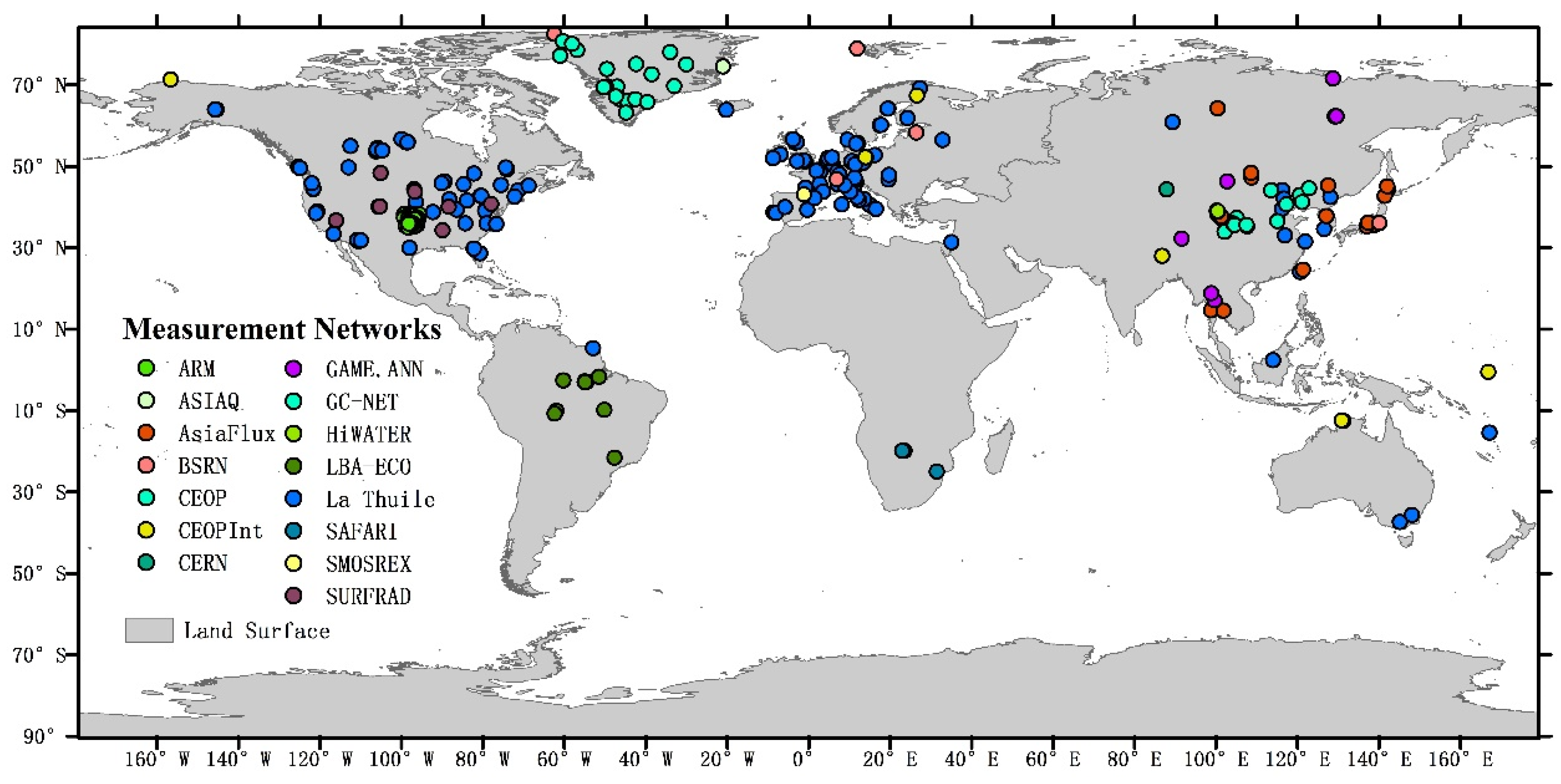
| Abbr. | Full Name | Num. | URL |
|---|---|---|---|
| La Thuile | La Thuile dataset | 188 | [26] |
| CEOP | Coordinated Enhanced Observation Network of China | 16 | \ |
| CERN | Chinese Ecosystem Research Network | 1 | [27] |
| AsiaFlux | AsiaFlux dataset | 19 | [28] |
| GAME.ANN | GEWEX Asian Monsoon Experiment | 13 | \ |
| SURFRAD | Surface Radiation Network | 7 | [29] |
| BSRN | Baseline Surface Radiation Network | 5 | [30] |
| ARM | Atmospheric Radiation Measurement | 29 | [31] |
| SMOSREX | Surface Monitoring of Soil Reservoir Experiment | 1 | [32] |
| CEOPInt | \ | 7 | \ |
| ASIAQ | Asiaq- Greenland Survey | 1 | [33] |
| GC-NET | Greenland Climate Network | 21 | [34] |
| HiWATER | HiWATER dataset | 20 | \ |
| LBA-ECO | The Large-Scale Biosphere-Atmosphere Experiment in Ecology | 10 | [35] |
| SAFARI | A Southern African Regional Science Initiative | 2 | [36] |
2.1.3. Land Cover Type Data
2.1.4. Data for Attribution Analysis
| Driving Factors | Sources | Units | Space Resolution | Time Resolution | Time Range |
|---|---|---|---|---|---|
| Precipitation (Pre) | Climatic Research Unit (CRU) TS3.22 Precipitation [41] | mm | 0.5° | monthly | 1.2000–12.2013 |
| Cloud Cover (CC) | Climatic Research Unit (CRU) TS3.22 Cloud Cover [41] | % | 0.5° | monthly | 1.2000–12.2012 |
| Temperature Range (TΔ) | CRU TS3.22 Diurnal Temperature Range [41] | °C | 0.5° | monthly | 1.2000–12.2013 |
| Surface Mean Temperature (Tm) | CRU TS3.22 Mean Temperature [41] | °C | 0.5° | monthly | 1.2000–12.2013 |
| NDVI | GLASS products [42,43] | \ | 0.05° | 8 days | 1.2000–12.2013 |
| Snow Cover (SC) | MODIS/Terra [44] | % | 0.05° | monthly | 1.2000–12.2013 |
| Albedo | GLASS products [42,45,46] | \ | 0.05° | 8 days | 1.2000–12.2013 |
2.2. Methodology
2.2.1. Validation
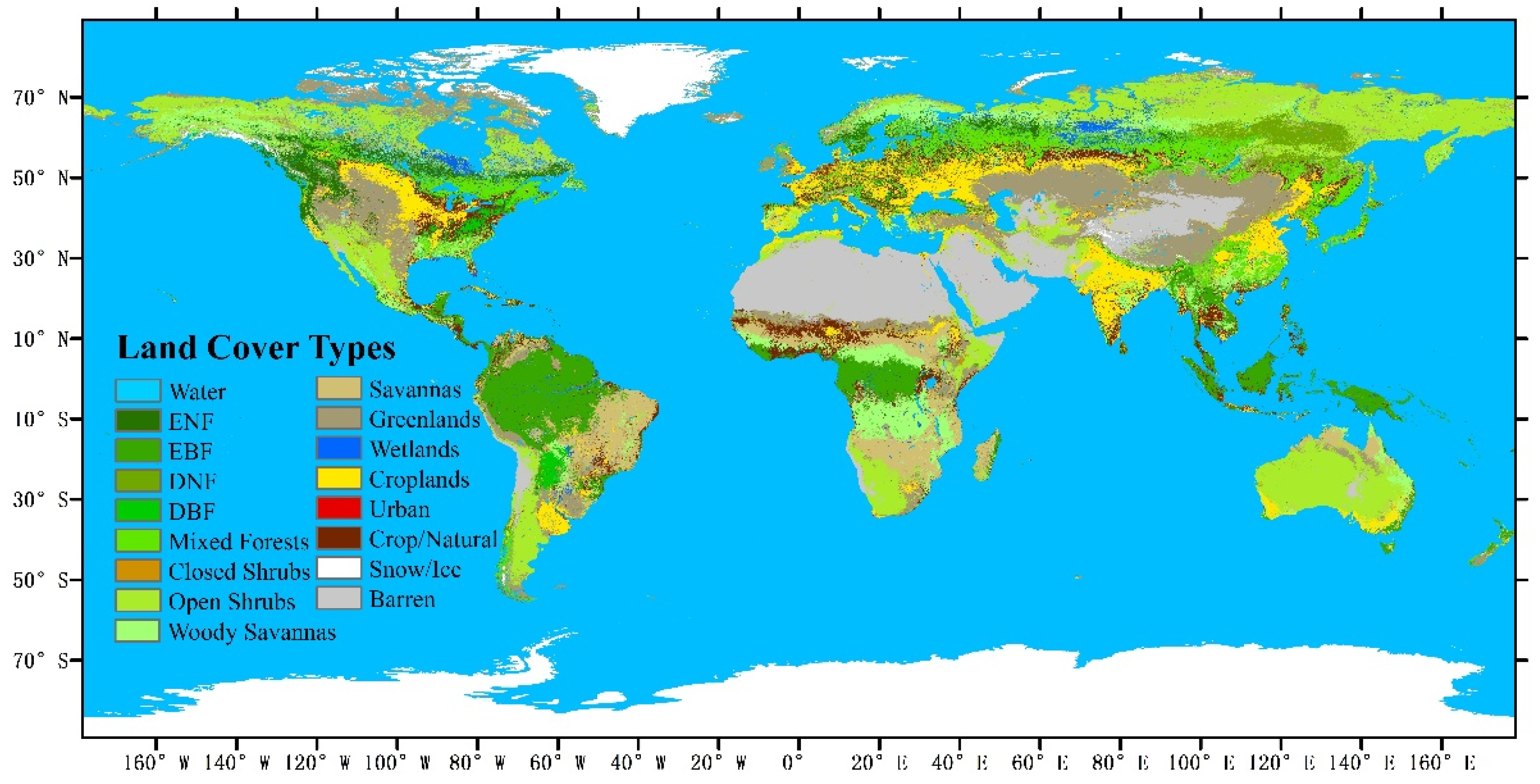
| Code Names | Land Cover Types | Code Names | Land Cover Types |
|---|---|---|---|
| 0 | Water | 9 | Savannas |
| 1 | Evergreen Needle leaf Forest | 10 | Grasslands |
| 2 | Evergreen Broadleaf Forest | 11 | Permanent Wetland |
| 3 | Deciduous Needle leaf Forest | 12 | Croplands |
| 4 | Deciduous Broadleaf Forest | 13 | Urban and Built-Up |
| 5 | Mixed Forests | 14 | Cropland/Natural Vegetation |
| 6 | Closed Shrublands | 15 | Snow and Ice |
| 7 | Open Shrublands | 16 | Barren or Sparsely Vegetated |
| 8 | Woody Savannas |
2.2.2. Spatiotemporal Analysis
3. Results Analysis and Discussion
3.1. Validation of the CERES Rn Product
3.1.1. Daily Scale
3.1.2. Monthly Scale
3.2. Spatiotemporal Analysis
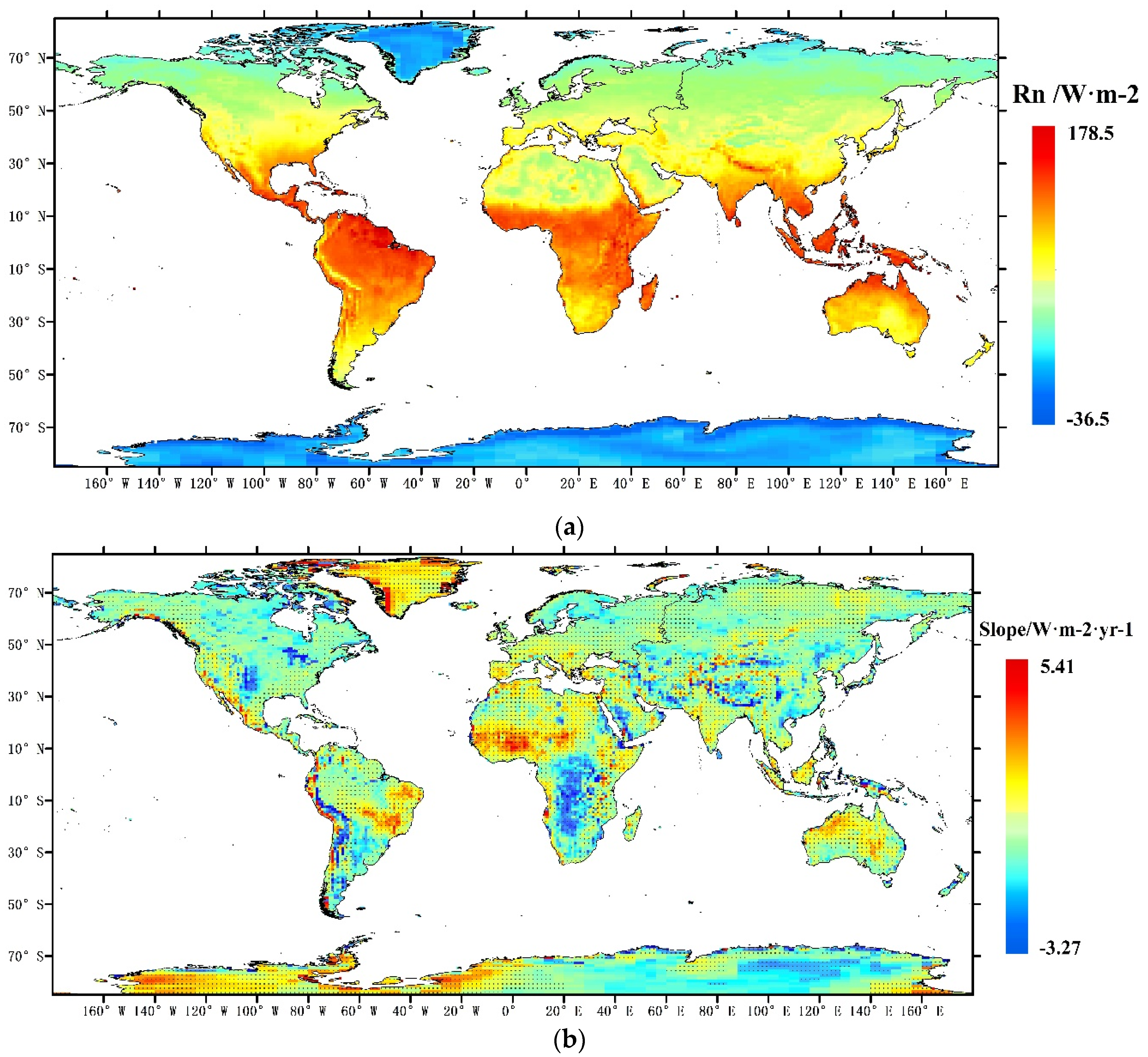
3.2.1. Global Analysis of Rn
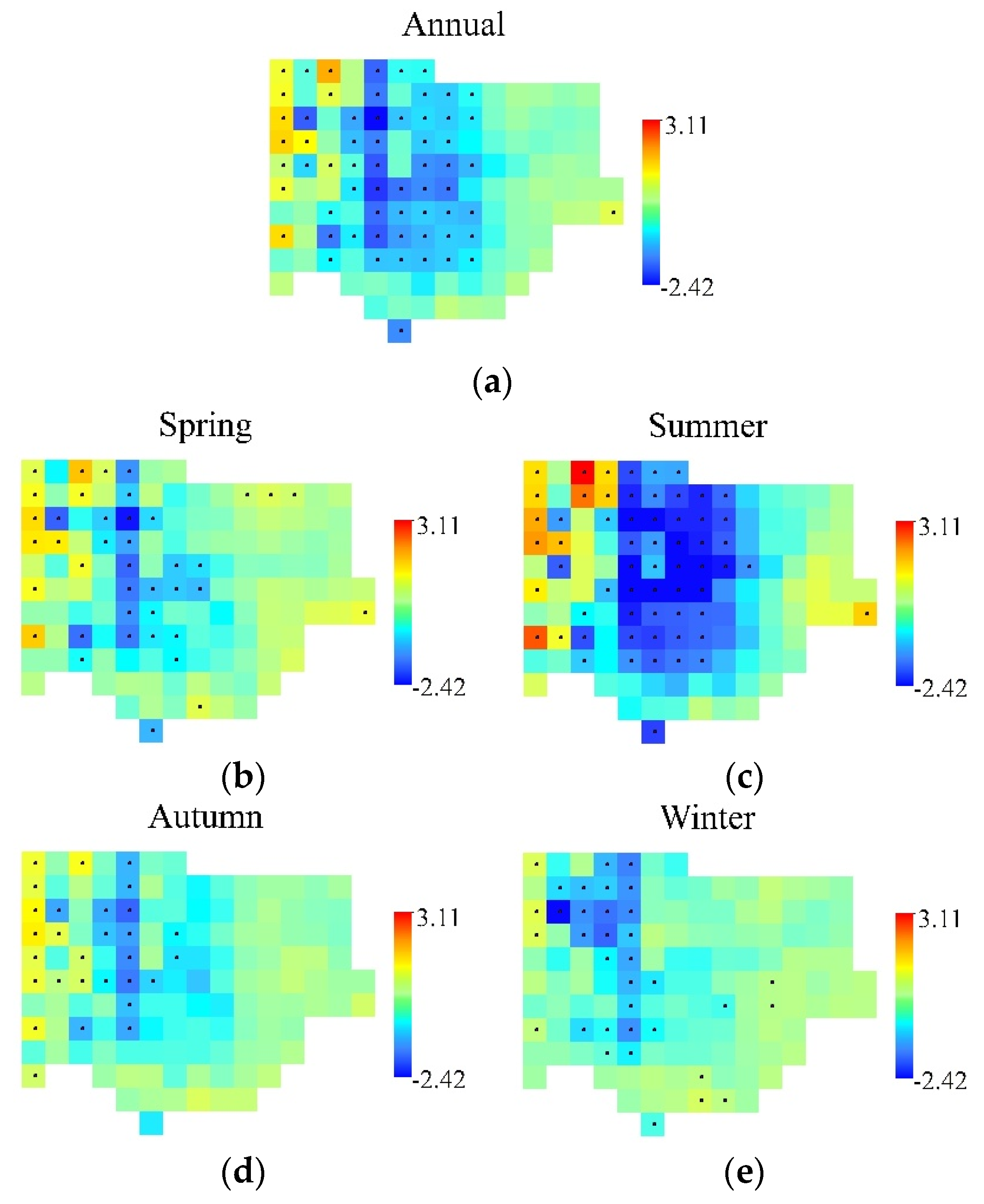
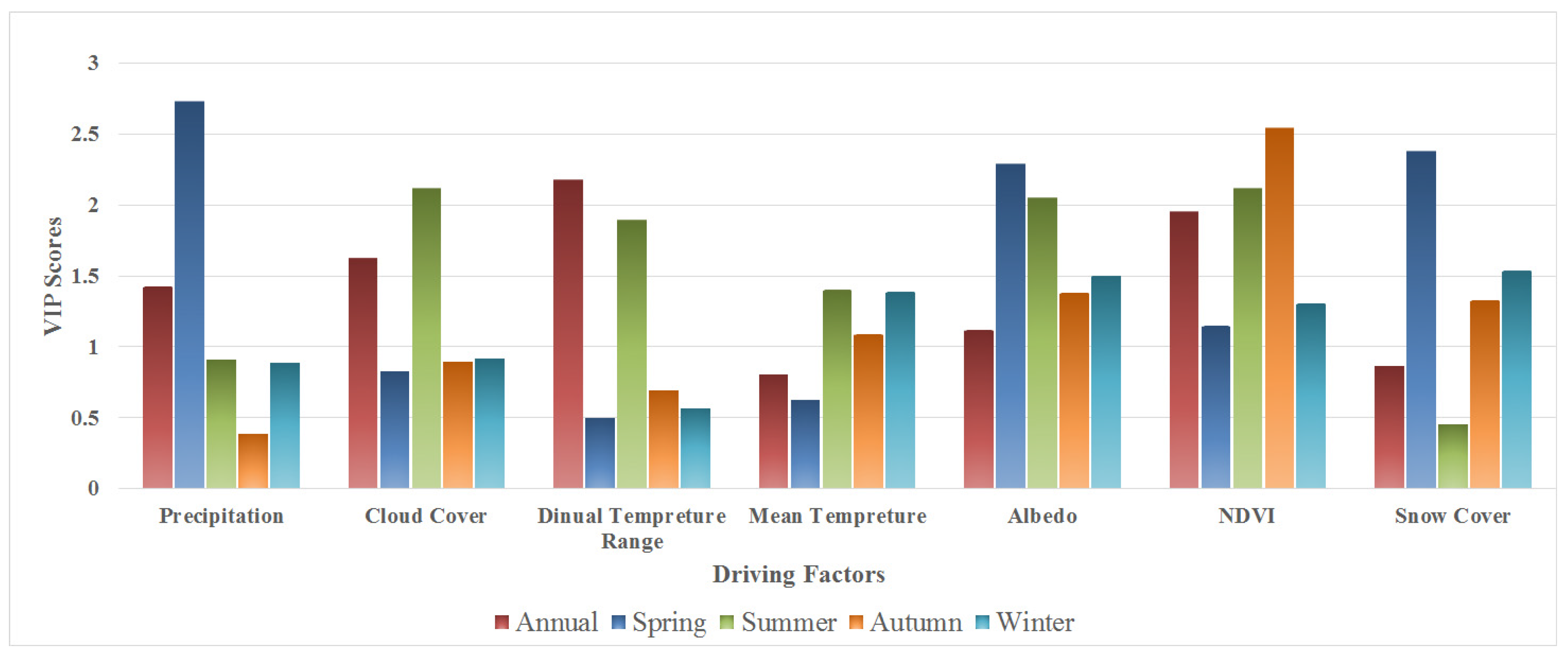
3.2.2. Southern Great Plains
| Annual | Spring | Summer | Autumn | Winter | ||||||
|---|---|---|---|---|---|---|---|---|---|---|
| R | %SS | R | %SS | R | %SS | R | %SS | R | %SS | |
| Rn and Pre | 0.47 * | 5 | −0.16 | 2 | 0.26 | 25 | 0.02 | 1 | −0.45 | 0 |
| Rn and CC | 0.56 ** | 16 | −0.05 | 0 | 0.60 ** | 36 | 0.17 | 13 | −0.47 * | 4 |
| Rn and TΔ | −0.77 ** | 12 | −0.03 | 0 | −0.53 ** | 0 | −0.09 | 0 | 0.29 | 0 |
| Rn and Tm | −0.15 | 0 | −0.04 | 0 | −0.39 | 8 | 0.25 | 2 | 0.71 ** | 2 |
| Rn and Albedo | −0.27 | 0 | −0.12 | 34 | −0.58 ** | 4 | −0.35 | 12 | −0.77 ** | 8 |
| Rn and NDVI | 0.71 ** | 51 | 0.06 | 3 | 0.60 ** | 5 | 0.71 ** | 50 | 0.66 | 8 |
| Rn and SC | −0.11 | 8 | 0.13 | 2 | −0.13 | 1 | −0.34 | 3 | −0.78 ** | 62 |
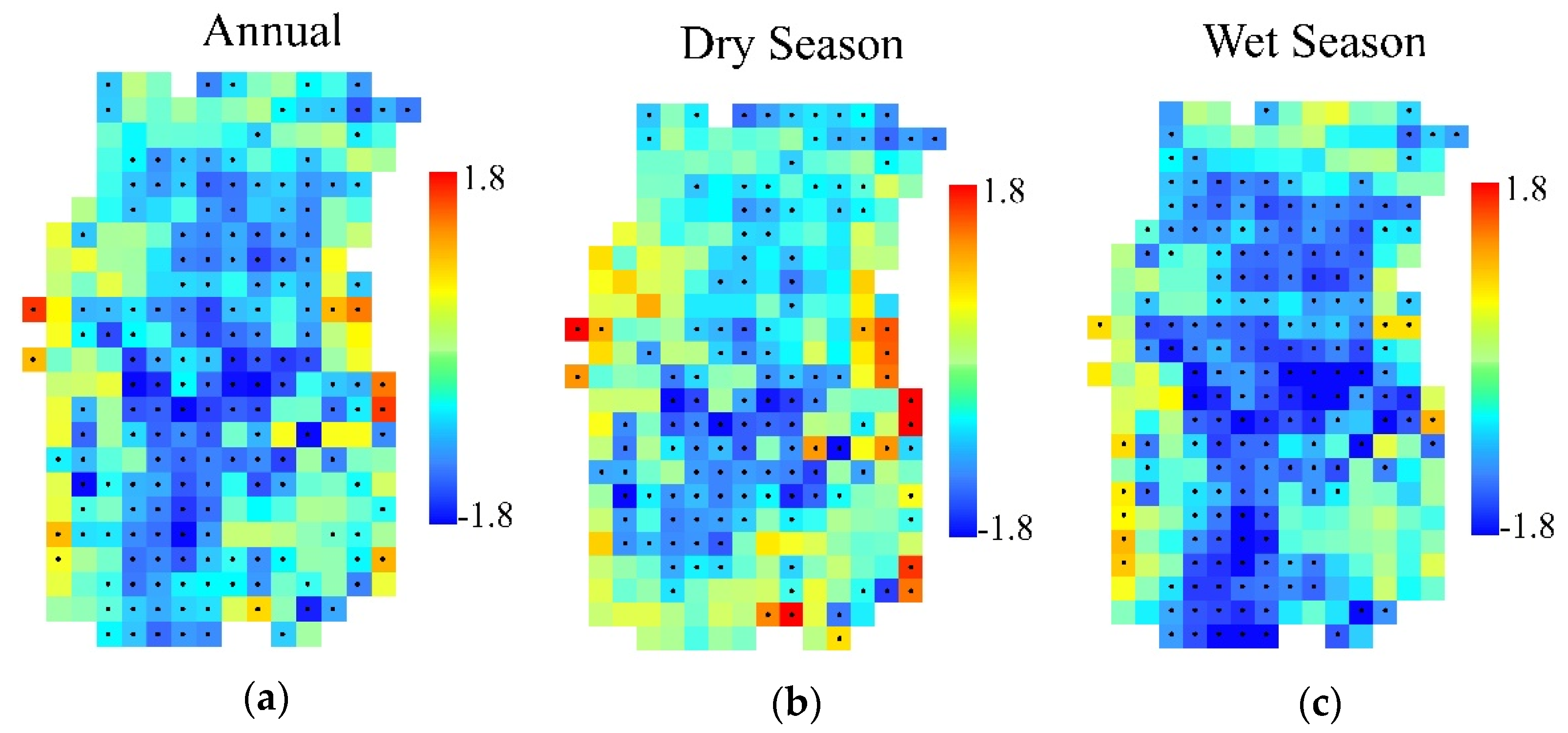
3.2.3. South-Central Africa
| Annual | Dry Season | Wet Season | ||||
|---|---|---|---|---|---|---|
| R | %SS | R | %SS | R | %SS | |
| Rn and Pre | 0.15 | 2 | 0.11 | 2 | −0.12 | 3 |
| Rn and CC | −0.10 | 0 | 0.24 | 0 | −0.39 | 1 |
| Rn and TΔ | 0.06 | 0 | −0.37 | 2 | 0.39 | 9 |
| Rn and Tm | 0.37 | 8 | 0.15 | 2 | 0.48 * | 5 |
| Rn and Albedo | −0.52 * | 1 | −0.34 | 10 | 0.44 | 6 |
| Rn and NDVI | 0.80 ** | 63 | 0.75 ** | 56 | 0.51 * | 26 |
4. Conclusions
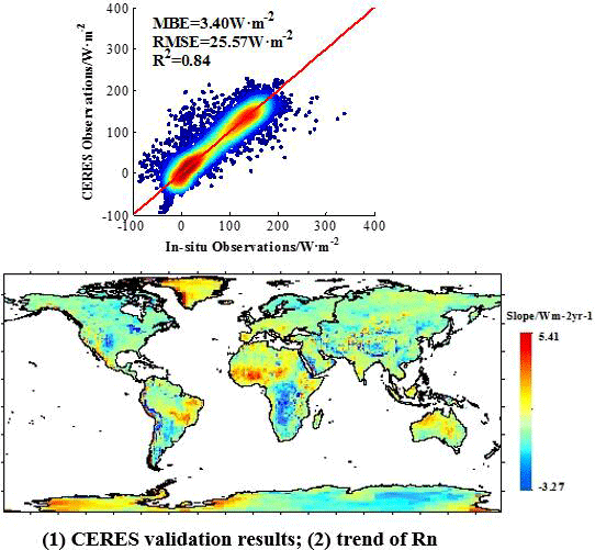
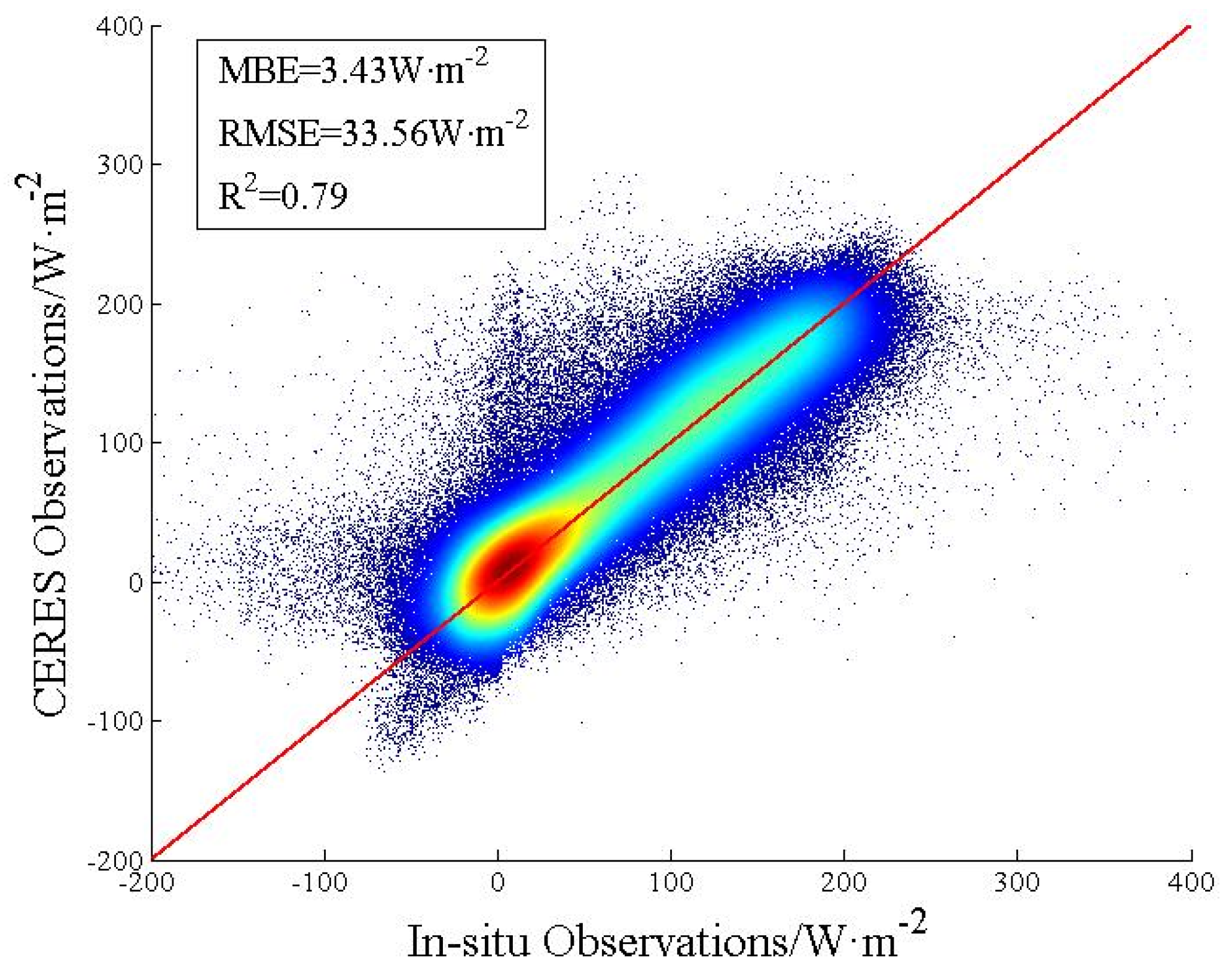
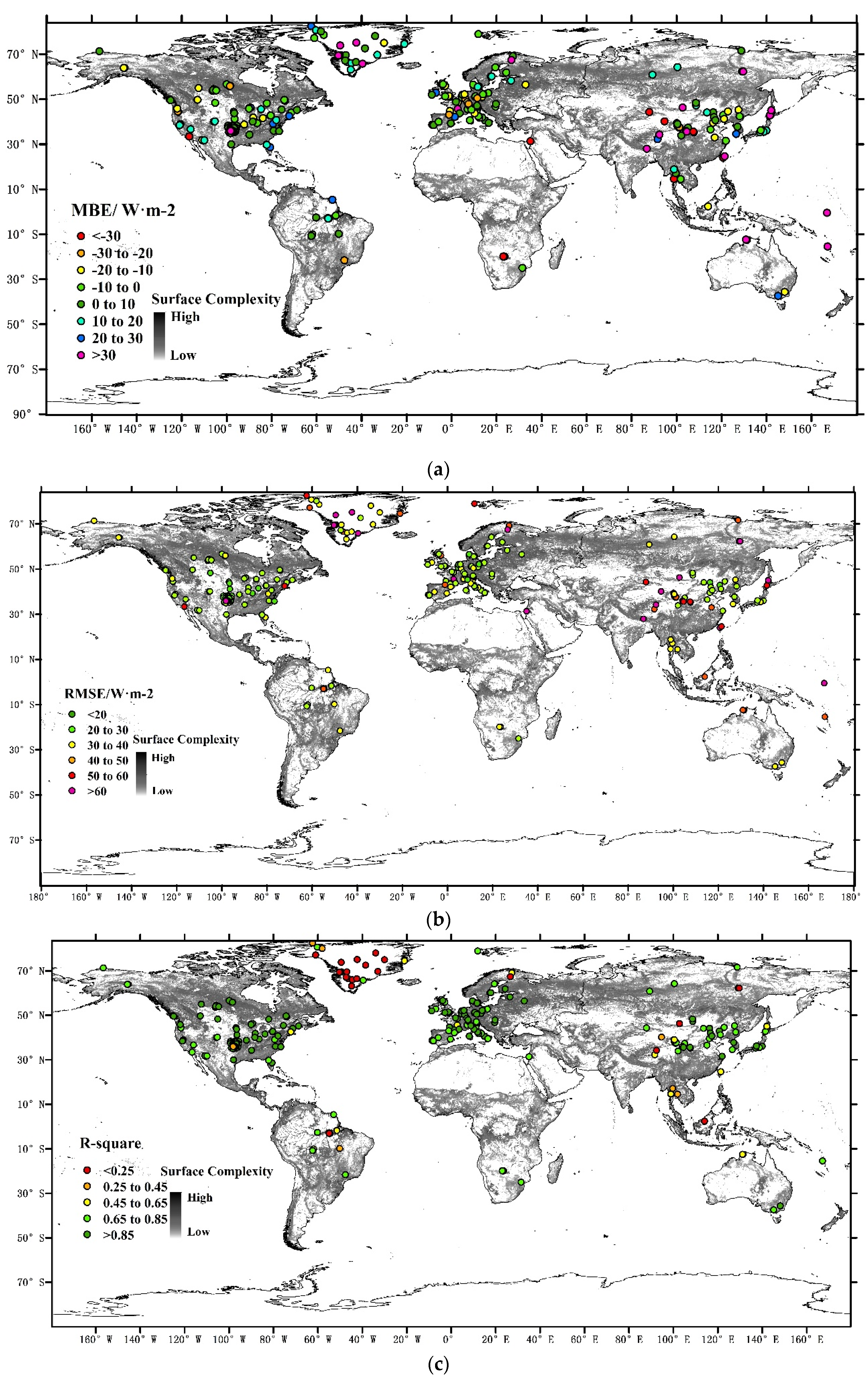
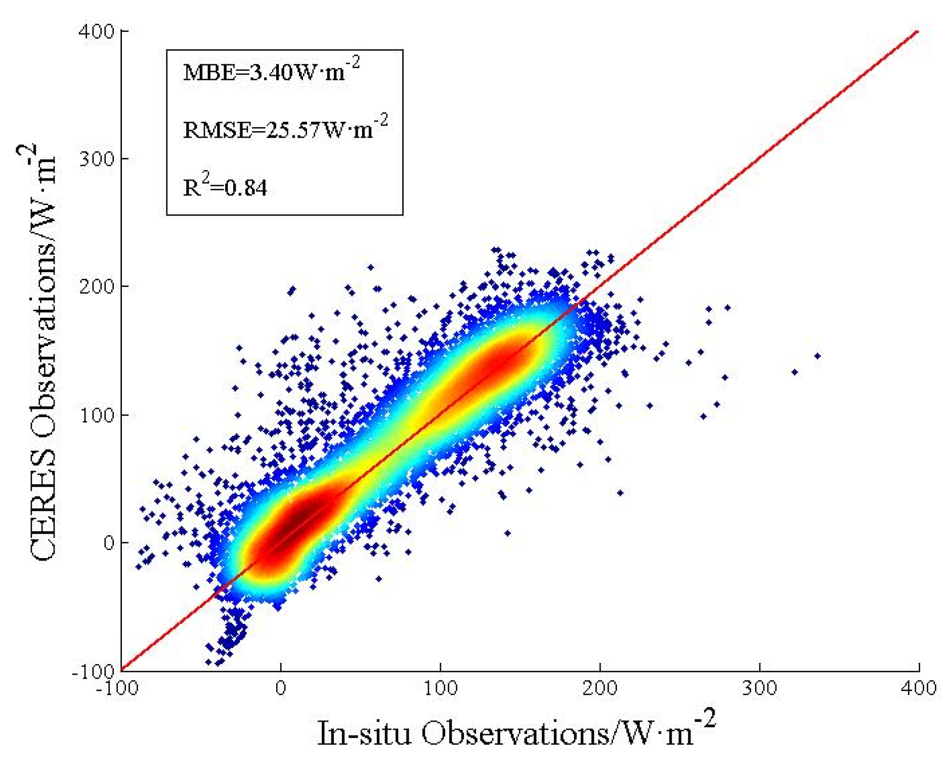
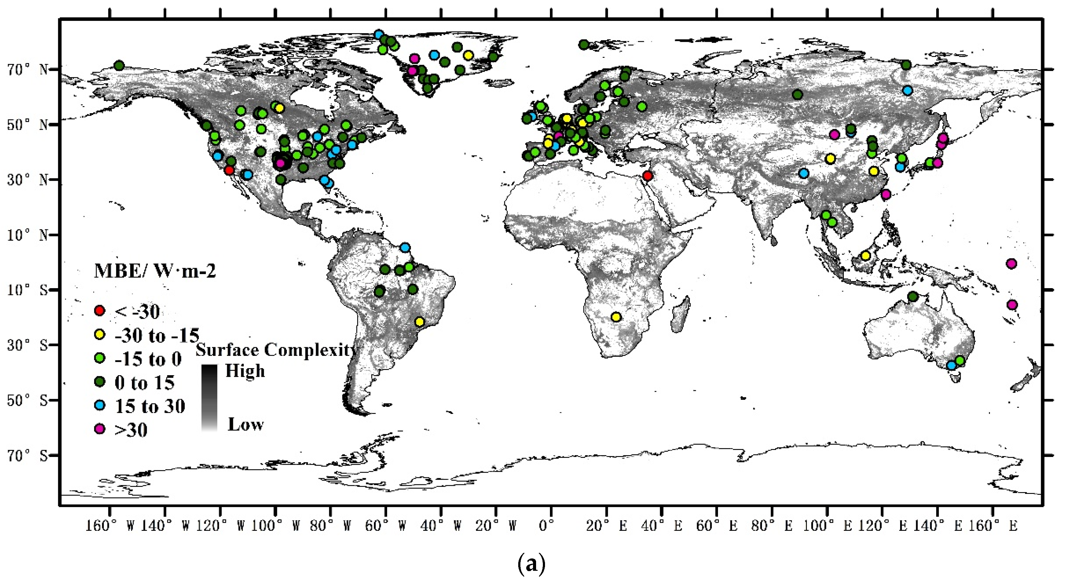
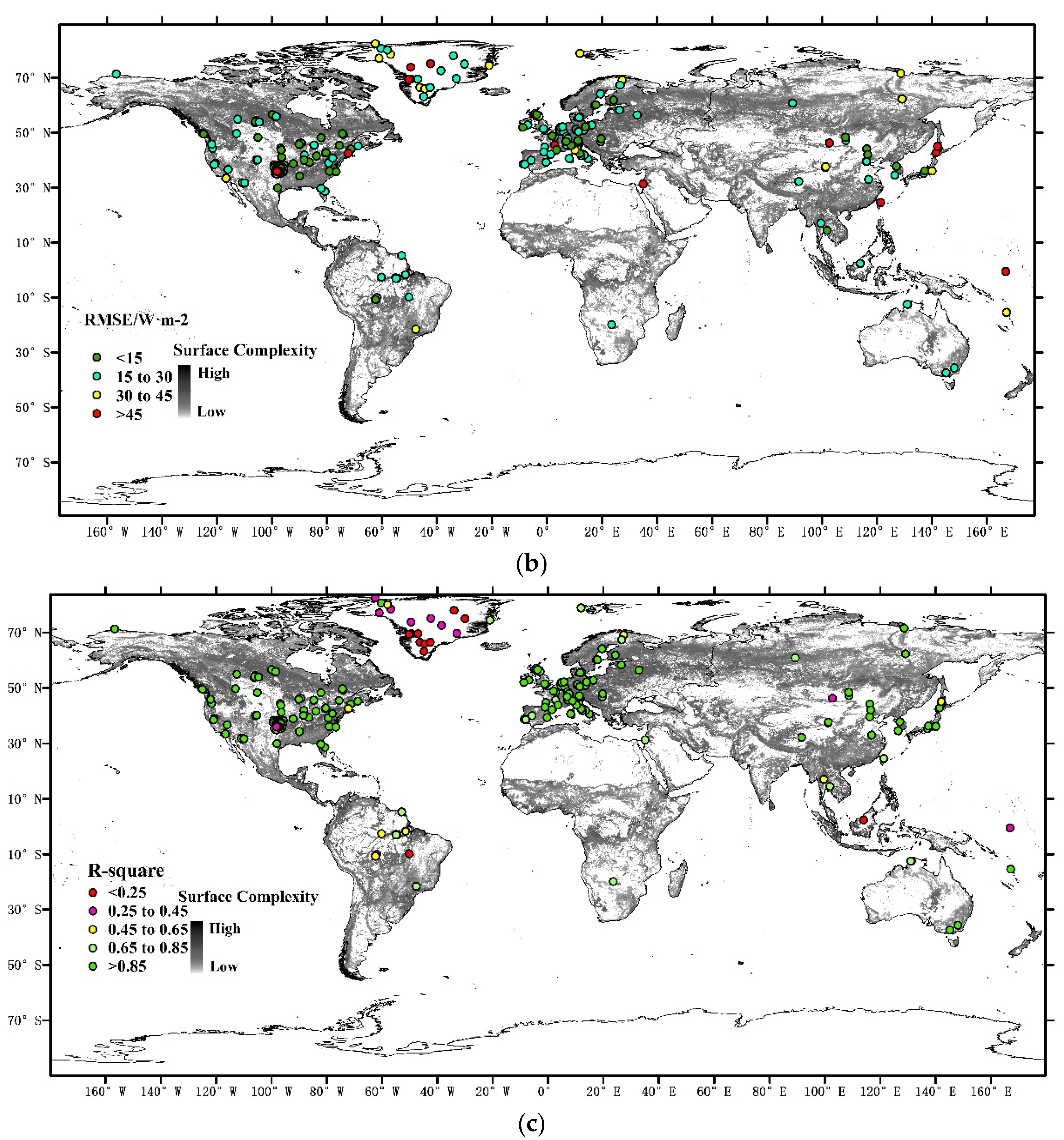
- This paper validated the CERES_SYN1deg_Ed3A all-sky surface Rn at a daily and monthly basis, respectively. The daily validations had an MBE of 3.43 W·m−2, RMSE of 33.56 W·m−2, and R2 of 0.79. The monthly validations had an MBE of 3.40 W·m−2, RMSE of 25.57 W·m−2, and R2 of 0.84. Considering that the CERES_Ed2b was previously found to have a systematic bias of 14~21 W·m−2 [16], the integral accuracy of the CERES_SYN1deg_Ed3A is high enough for use in scientific research.
- The accuracy distribution of the daily and monthly CERES Rn products were calculated. It was found that areas in the middle and low latitudes had a higher accuracy, and that the R2 was lower for areas in the high latitudes, such as Greenland. This may be caused by the lower accuracy of CERES inversion over the snow surface. The uncertainty near the coast was caused by the coarse resolution of the CERES products matching with in situ observations.
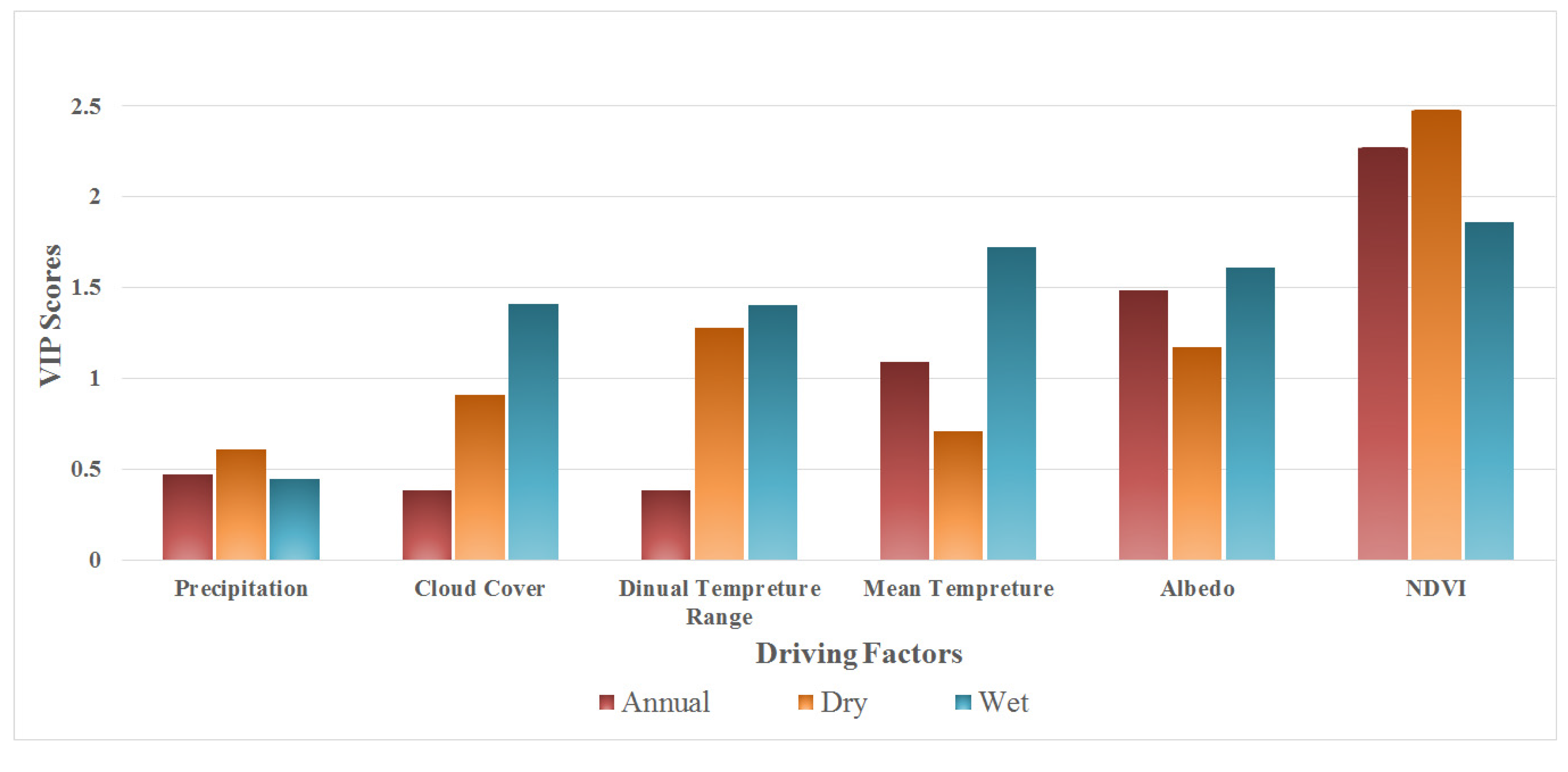
- This study analyzed the spatiotemporal variation of the monthly CERES Rn, from 2001 to 2013, and found that different regions exhibited vastly differing rates of change. In terms of the hot spot analysis, the Rn decreased slightly over the entire southern Great Plains, with a gradient of −0.33 W·m−2 per year. As for the attribution analysis, percentage sum of squares explained and VIP scores were calculated. From the annual and seasonal analysis, we concluded that NDVI, which represents the surface vegetation condition, was the major driving factor of the Rn variation over the southern Great Plains and that precipitation played an indispensable role. We determined that little precipitation was one of reasons for the deterioration of the vegetation. Moreover, barren soil increased the TΔ and added more ULW. In the winter, SC was the main factor of Rn variation because it easily changed the albedo and controlled shortwave radiation. The Rn over south-central Africa decreased at a rate of −0.63 W·m−2 per year, with NDVI as the main driving factor. Regardless of the analysis period, NDVI was always the leading factor, as evidenced by the high VIP scores and %SS. Different from the case of the Great Plains, precipitation showed little correlation with Rn variation. This may be attributed to the little variation of precipitation, particularly during the wet season.
Acknowledgments
Author Contributions
Conflicts of Interest
References
- Liang, S. Quantitative Remote Sensing of Land Surfaces; John Wiley & Sons: Hoboken, NJ, USA, 2005; Volume 30. [Google Scholar]
- Wild, M.; Folini, D.; Schär, C.; Loeb, N.; Dutton, E.G.; König-Langlo, G. The global energy balance from a surface perspective. Clim. Dyn. 2013, 40, 3107–3134. [Google Scholar] [CrossRef]
- Liang, S.; Wang, K.; Zhang, X.; Wild, M. Review on estimation of land surface radiation and energy budgets from ground measurement, remote sensing and model simulations. IEEE J. Sel. Top. Appl. Earth Obs. Remote Sens. 2010, 3, 225–240. [Google Scholar] [CrossRef]
- Gui, S. Satellite Remote Sensing of Surface Net Radiation Doctor; Wuhan University: Wuhan, China, 2010. [Google Scholar]
- Jiang, B.; Zhang, Y.; Liang, S.; Wohlfahrt, G.; Arain, A.; Cescatti, A.; Georgiadis, T.; Jia, K.; Kiely, G.; Lund, M. Empirical estimation of daytime net radiation from shortwave radiation and ancillary information. Agric. For. Meteorol. 2015, 211, 23–36. [Google Scholar] [CrossRef]
- Jiang, B.; Zhang, Y.; Liang, S.; Zhang, X.; Xiao, Z. Surface Daytime Net Radiation Estimation Using Artificial Neural Networks. Remote Sens. 2014, 6, 11031–11050. [Google Scholar] [CrossRef]
- Wielicki, B.A.; Barkstrom, B.R.; Harrison, E.F.; Lee, R.B.; Louis Smith, G.; Cooper, J.E. Clouds and the Earth’s Radiant Energy System (CERES): An earth observing system experiment. Bull. Am. Meteorol. Soc. 1996, 77, 853–868. [Google Scholar] [CrossRef]
- Charlock, T.P.; Alberta, T.L. The CERES/ARM/GEWEX Experiment (CAGEX) for the retrieval of radiative fluxes with satellite data. Bull. Am. Meteorol. Soc. 1996, 77, 2673–2683. [Google Scholar] [CrossRef]
- Fu, Q.; Liou, K. Parameterization of the radiative properties of cirrus clouds. J. Atmos. Sci. 1993, 50, 2008–2025. [Google Scholar] [CrossRef]
- Rutan, D.A.; Charlock, T.P.; Rose, F.G.; Smith, N.M. CERES/ARM Validation Experiment. In Proceedings of the 11th Conference on Satellite Meteorology and Oceanography, Madison, WI, USA, 15–18 October 2001; pp. 606–609.
- Rutan, D.; Rose, F.; Smith, N.; Charlock, T. CERES/ARM Validation Experiment. In Proceedings of the 11th ARM Science Team Meeting, Atlanta, GA, USA, 19–23 March 2001; pp. 1–4.
- Rutan, D.A.; Charlock, T. Validation of CERES/SARB data product using ARM surface flux observations. In Proceedings of the 14th ARM Science Team Meeting Proceedings, Albuquerque, NM, USA, 22–26 March 2004.
- Gui, S.; Liang, S.; Li, L. In Validation of surface radiation data provided by the CERES over the Tibetan Plateau. In Proceedings of the 2009 17th International Conference on Geoinformatics, Fairfax, VA, USA, 12–14 August 2009; pp. 1–6.
- Wang, L.; Lü, D.; He, Q. The impact of surface properties on downward surface shortwave radiation over the Tibetan Plateau. Adv. Atmos. Sci. 2015, 32, 759–771. [Google Scholar] [CrossRef]
- Pan, X.; Liu, Y.; Fan, X. Comparative Assessment of Satellite-Retrieved Surface Net Radiation: An Examination on CERES and SRB Datasets in China. Remote Sens. 2015, 7, 4899–4918. [Google Scholar] [CrossRef]
- Kratz, D.P.; Gupta, S.K.; Wilber, A.C.; Sothcott, V.E. Validation of the CERES Edition 2B surface-only flux algorithms. J. Appl. Meteorol. Climatol. 2010, 49, 164–180. [Google Scholar] [CrossRef]
- Charlock, T.; Rose, F.G.; Rutan, D.A.; Jin, Z.; Su, W.; Rutledge, K.; Smith, W. Retrieval and Validation of Radiative Fluxes at the Ocean Surface with CIRES; World Meteorological Organization: Geneva, Switzerland, 2001; pp. 228–231. [Google Scholar]
- Charlock, T.; Rose, F.; Jin, Z.; Smith, W.; Rutledge, K.; Rutan, D. Validation of the CERES Surface and Atmospheric Radiation Budget Using the CLAMS Aircraft Campaign and COVE Ocean Platform; AGU Spring Meeting: Washington, DC, USA, 2002; p. 11. [Google Scholar]
- Wild, M.; Folini, D.; Hakuba, M.Z.; Schär, C.; Seneviratne, S.I.; Kato, S.; Rutan, D.; Ammann, C.; Wood, E.F.; König-Langlo, G. The energy balance over land and oceans: An assessment based on direct observations and CMIP5 climate models. Clim. Dyn. 2014, 44, 3393–3429. [Google Scholar] [CrossRef]
- Jiménez-Muñoz, J.C.; Sobrino, J.A.; Mattar, C. Recent trends in solar exergy and net radiation at global scale. Ecol. Model. 2012, 228, 59–65. [Google Scholar] [CrossRef]
- Gao, Y.; Honglin, H.E.; Zhang, L.; Qianqian, L.U.; Guirui, Y.U.; Zhang, Z. Spatio-temporal Variation Characteristics of Surface Net Radiation in China over the Past 50 Years. J. Geoinf. Sci. 2013, 15, 1–10. [Google Scholar] [CrossRef]
- Shi, Q.; Liang, S. Characterizing the surface radiation budget over the Tibetan Plateau with ground-measured, reanalysis, and remote sensing data sets: 2. Spatiotemporal analysis. J. Geophys. Res. Atmos. 2013, 118, 8921–8934. [Google Scholar] [CrossRef]
- Smith, G.; Priestley, K.; Loeb, N.; Wielicki, B.; Charlock, T.; Minnis, P.; Doelling, D.; Rutan, D. Clouds and Earth Radiant Energy System (CERES), a review: Past, present and future. Adv. Space Res. 2011, 48, 254–263. [Google Scholar] [CrossRef]
- Young, D.; Minnis, P.; Doelling, D.; Gibson, G.; Wong, T. Temporal interpolation methods for the Clouds and the Earth’s Radiant Energy System (CERES) experiment. J. Appl. Meteorol. 1998, 37, 572–590. [Google Scholar] [CrossRef]
- CERES Official Website. Available online: http://ceres.larc.nasa.gov/ (accessed on 15 March 2015).
- Fluxnet. Available online: http://www.fluxdata.org/ (accessed on 18 May 2014).
- CERN. Available online: http://www.cerndata.ac.cn/ (accessed on 21 May 2014).
- AsiaFlux. Available online: http://www.asiaflux.net/ (accessed on 22 April 2014).
- ESRL Global Mnotoring Division-Global Radiation Group. Available online: http://www.esrl.noaa.gov/gmd/grad/surfrad/ (accessed on 5 June 2014).
- BSRN-World Radiation Monitoring Center Baseline Surface Radiation Network. Available online: http://www.bsrn.awi.de/ (accessed on 11 April 2014).
- U.S. Department of Energy. ARM-Data. Available online: http://www.archive.arm.gov/ (accessed on 25 March 2014).
- Centre d’Etudes Spatiales de la BIOsphère. Available online: http://www.cesbio.ups-tlse.fr/ (accessed on 3 May 2014).
- Asiaq-Greenland Survey. Available online: http://www.archive.arm.gov/ (accessed on 16 April 2014).
- Greenland Climate Network (GC-Net). Available online: http://cires.colorado.edu/science/groups/steffen/gcnet/ (accessed on 27 March 2014).
- LBA-ECO. Available online: http://www.lbaeco.org/ (accessed on 14 March 2014).
- SAFARI. Available online: http://daac.ornl.gov/S2K/safari.shtml (accessed on 12 June 2014).
- Broxton, P.D.; Zeng, X.; Sulla-Menashe, D.; Troch, P.A. A global land cover climatology using MODIS data. J. Appl. Meteorol. Climatol. 2014, 53, 1593–1605. [Google Scholar] [CrossRef]
- Pettorelli, N.; Vik, J.O.; Mysterud, A.; Gaillard, J.-M.; Tucker, C.J.; Stenseth, N.C. Using the satellite-derived NDVI to assess ecological responses to environmental change. Trends Ecol. Evol. 2005, 20, 503–510. [Google Scholar] [CrossRef] [PubMed]
- Van de Griend, A.; Owe, M. On the relationship between thermal emissivity and the normalized difference vegetation index for natural surfaces. Int. J. Remote Sens. 1993, 14, 1119–1131. [Google Scholar] [CrossRef]
- Brutsaert, W. On a derivable formula for long-wave radiation from clear skies. Water Resour. Res. 1975, 11, 742–744. [Google Scholar] [CrossRef]
- Jones, P.D.; Harris, I. Climatic Research Unit (CRU) Time-Series Datasets of Variations in Climate with Variations in Other Phenomena; Centre for Environment Data: Didcot, UK, 2008. [Google Scholar]
- Zhao, X.; Liang, S.; Liu, S.; Yuan, W.; Xiao, Z.; Liu, Q.; Cheng, J.; Zhang, X.; Tang, H.; Zhang, X. The Global Land Surface Satellite (GLASS) remote sensing data processing system and products. Remote Sens. 2013, 5, 2436–2450. [Google Scholar] [CrossRef]
- Liang, S.; Zhao, X.; Liu, S.; Yuan, W.; Cheng, X.; Xiao, Z.; Zhang, X.; Liu, Q.; Cheng, J.; Tang, H. A long-term Global LAnd Surface Satellite (GLASS) data-set for environmental studies. Int. J. Digit. Earth 2013, 6, 5–33. [Google Scholar] [CrossRef]
- Hall, D.; Salomonson, V.; Riggs, G. MODIS/Terra Snow Cover Monthly L3 Global 0.05deg CMG; National Snow and Ice Data Center: Boulder, CO, USA, 2006. [Google Scholar]
- Liu, Q.; Wang, L.; Qu, Y.; Liu, N.; Liu, S.; Tang, H.; Liang, S. Preliminary evaluation of the long-term GLASS albedo product. Int. J. Digit. Earth 2013, 6, 69–95. [Google Scholar] [CrossRef]
- Liu, N.; Liu, Q.; Wang, L.; Wen, J. A temporal filtering algorithm to reconstruct daily albedo series based on glass albedo product. In Proceedings of the IEEE International Geoscience and Remote Sensing Symposium (IGARSS), Vancouver, BC, Canada, 24–29 July 2011; pp. 4277–4280.
- Harris, I.; Jones, P.; Osborn, T.; Lister, D. Updated high-resolution grids of monthly climatic observations—The CRU TS3. 10 Dataset. Int.J. Climatol. 2014, 34, 623–642. [Google Scholar] [CrossRef]
- Vose, R.S.; Easterling, D.R.; Gleason, B. Maximum and minimum temperature trends for the globe: An update through 2004. Geophys. Res. Lett. 2005, 32. [Google Scholar] [CrossRef]
- Wang, X.; Fang, J.; Sanders, N.J.; White, P.S.; Tang, Z. Relative importance of climate vs local factors in shaping the regional patterns of forest plant richness across northeast China. Ecography 2009, 32, 133–142. [Google Scholar] [CrossRef]
- Austin, M.; Pausas, J.G.; Nicholls, A. Patterns of tree species richness in relation to environment in southeastern New South Wales, Australia. Aust. J. Ecol. 1996, 21, 154–164. [Google Scholar] [CrossRef]
- Zhang, Y.; Liang, S. Changes in forest biomass and linkage to climate and forest disturbances over Northeastern China. Glob. Chang. Biol. 2014, 20, 2596–2606. [Google Scholar] [CrossRef] [PubMed]
- Næsset, E.; Bollandsås, O.M.; Gobakken, T. Comparing regression methods in estimation of biophysical properties of forest stands from two different inventories using laser scanner data. Remote Sens. Environ. 2005, 94, 541–553. [Google Scholar] [CrossRef]
- Wold, S.; Sjöström, M.; Eriksson, L. PLS-regression: A basic tool of chemometrics. Chemom. Intell. Lab. Syst. 2001, 58, 109–130. [Google Scholar] [CrossRef]
- Inamdar, A.K.; Guillevic, P.C. Net Surface Shortwave Radiation from GOES Imagery—Product Evaluation Using Ground-Based Measurements from SURFRAD. Remote Sens. 2015, 7, 10788–10814. [Google Scholar] [CrossRef]
- Rossum, S.; Lavin, S. Where are the Great Plains? A cartographic analysis. Prof. Geogr. 2000, 52, 543–552. [Google Scholar] [CrossRef]
- Browne, R.B. Encyclopedia of the Great Plains. J. Am. Cult. 2005, 28. [Google Scholar] [CrossRef]
- Perkins, S. Tornado alley, USA: New map defines nation’s twister risk. Sci. News 2002, 161, 296–298. [Google Scholar] [CrossRef]
- Dai, A.; Trenberth, K.E.; Karl, T.R. Effects of clouds, soil moisture, precipitation, and water vapor on diurnal temperature range. J. Clim. 1999, 12, 2451–2473. [Google Scholar] [CrossRef]
- Cowling, R.M.; Richardson, D.M.; Pierce, S.M. Vegetation of Southern Africa; Cambridge University Press: Cambridge, UK, 2004. [Google Scholar]
- Hamann, R.; Kapelus, P. Corporate social responsibility in mining in Southern Africa: Fair accountability or just greenwash? Development 2004, 47, 85–92. [Google Scholar] [CrossRef]
- Tyson, P.D.; Preston-Whyte, R.A. Weather and Climate of Southern Africa; Oxford University Press: Oxford, UK, 2000. [Google Scholar]
© 2016 by the authors; licensee MDPI, Basel, Switzerland. This article is an open access article distributed under the terms and conditions of the Creative Commons by Attribution (CC-BY) license (http://creativecommons.org/licenses/by/4.0/).
Share and Cite
Jia, A.; Jiang, B.; Liang, S.; Zhang, X.; Ma, H. Validation and Spatiotemporal Analysis of CERES Surface Net Radiation Product. Remote Sens. 2016, 8, 90. https://doi.org/10.3390/rs8020090
Jia A, Jiang B, Liang S, Zhang X, Ma H. Validation and Spatiotemporal Analysis of CERES Surface Net Radiation Product. Remote Sensing. 2016; 8(2):90. https://doi.org/10.3390/rs8020090
Chicago/Turabian StyleJia, Aolin, Bo Jiang, Shunlin Liang, Xiaotong Zhang, and Han Ma. 2016. "Validation and Spatiotemporal Analysis of CERES Surface Net Radiation Product" Remote Sensing 8, no. 2: 90. https://doi.org/10.3390/rs8020090
APA StyleJia, A., Jiang, B., Liang, S., Zhang, X., & Ma, H. (2016). Validation and Spatiotemporal Analysis of CERES Surface Net Radiation Product. Remote Sensing, 8(2), 90. https://doi.org/10.3390/rs8020090


