
Long Term Subsidence Analysis and Soil Fracturing Zonation Based on InSAR Time Series Modelling in Northern Zona Metropolitana del Valle de Mexico

Abstract
:
1. Introduction
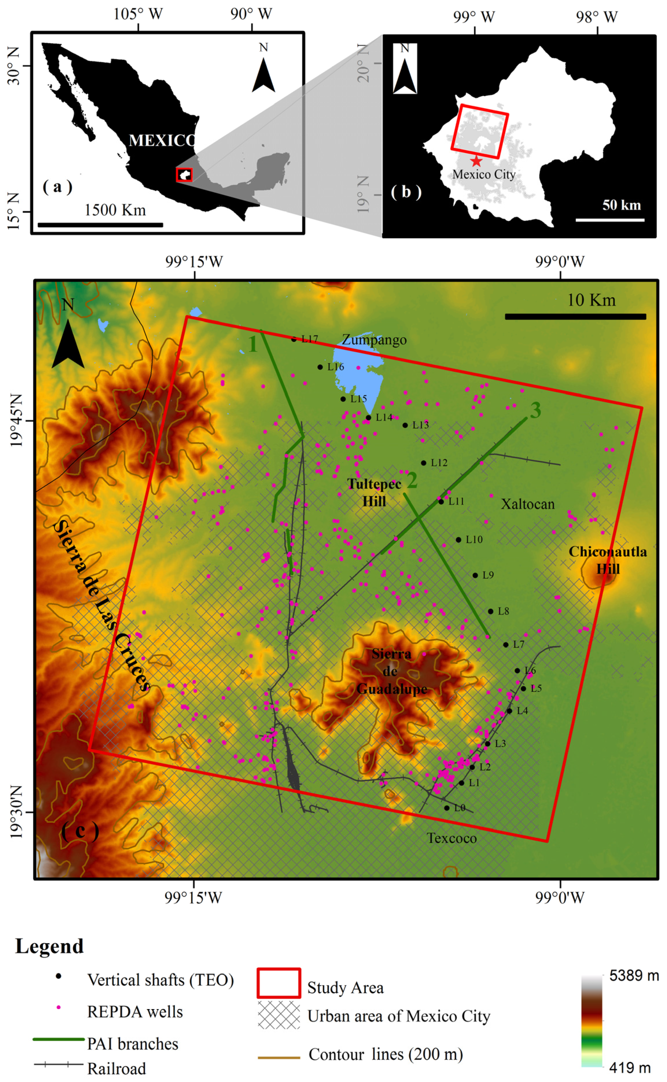
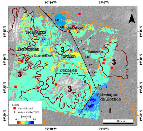
2. Study Area
3. Advanced InSAR Analysis
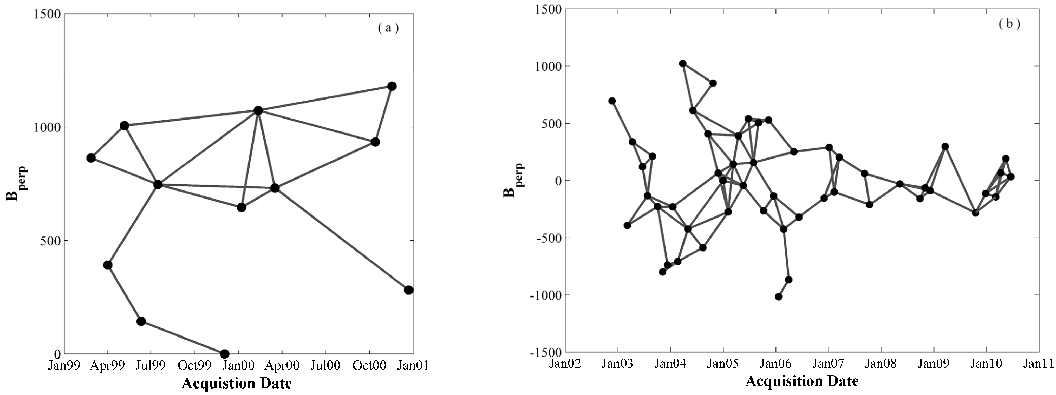
3.1. SAR Dataset and MTI Processing

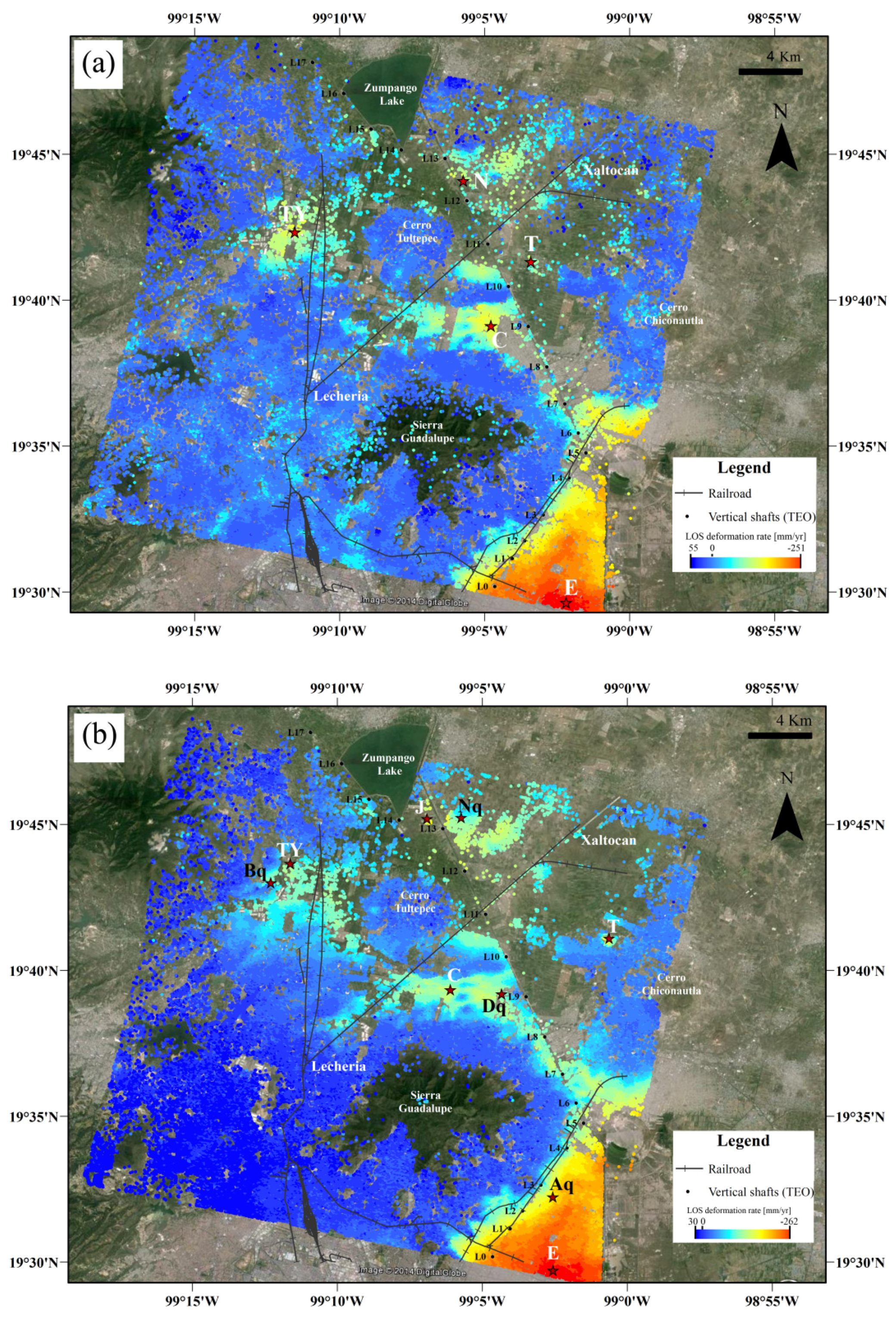
3.2. SBAS Results
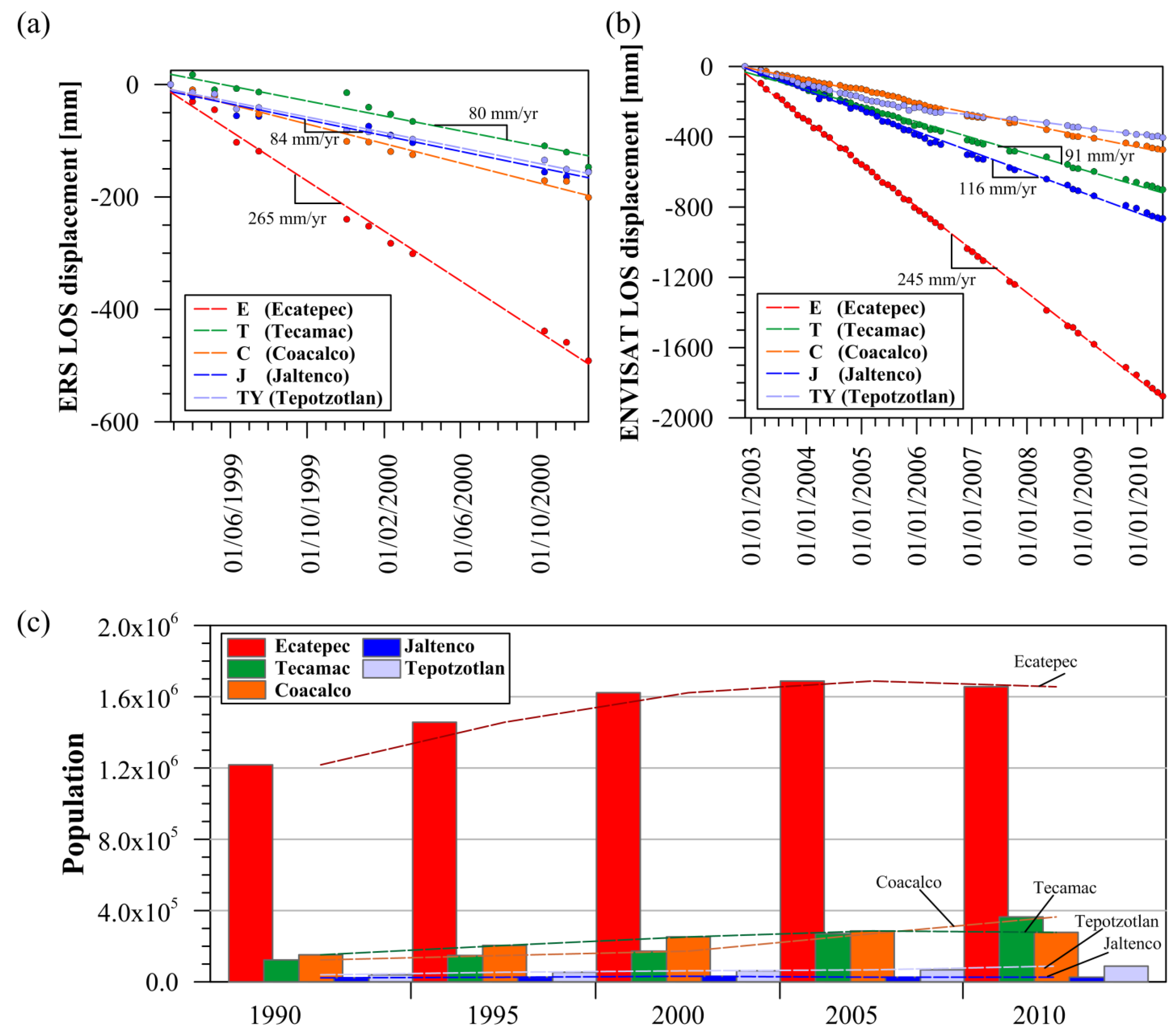
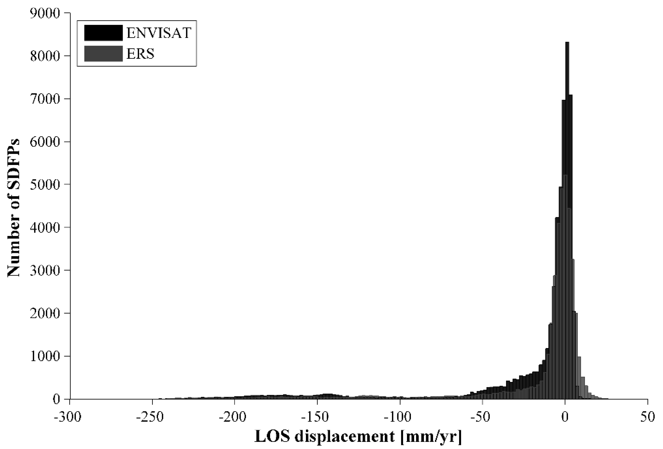
3.2.1. Global ERS and ENVISAT Results


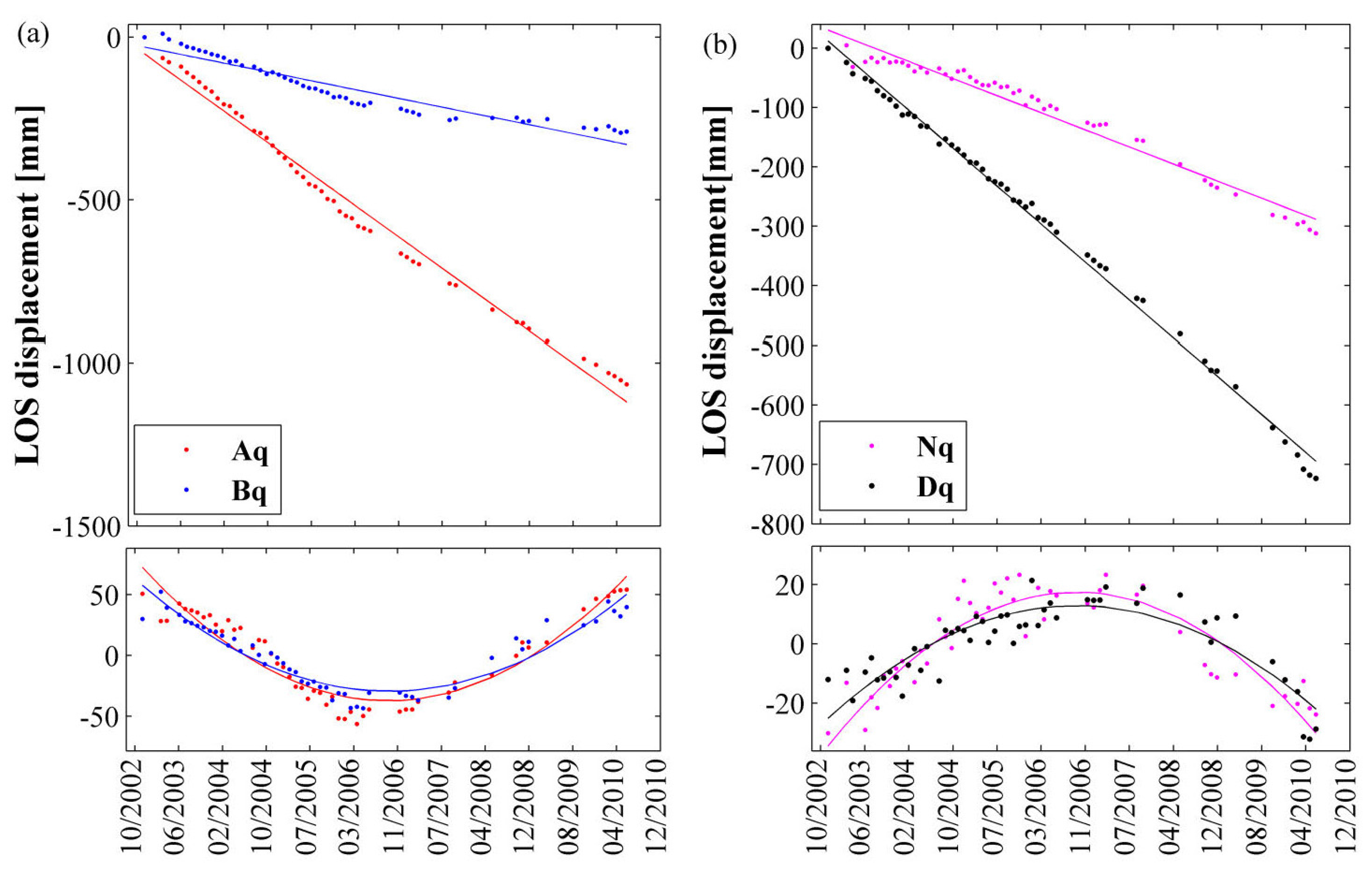
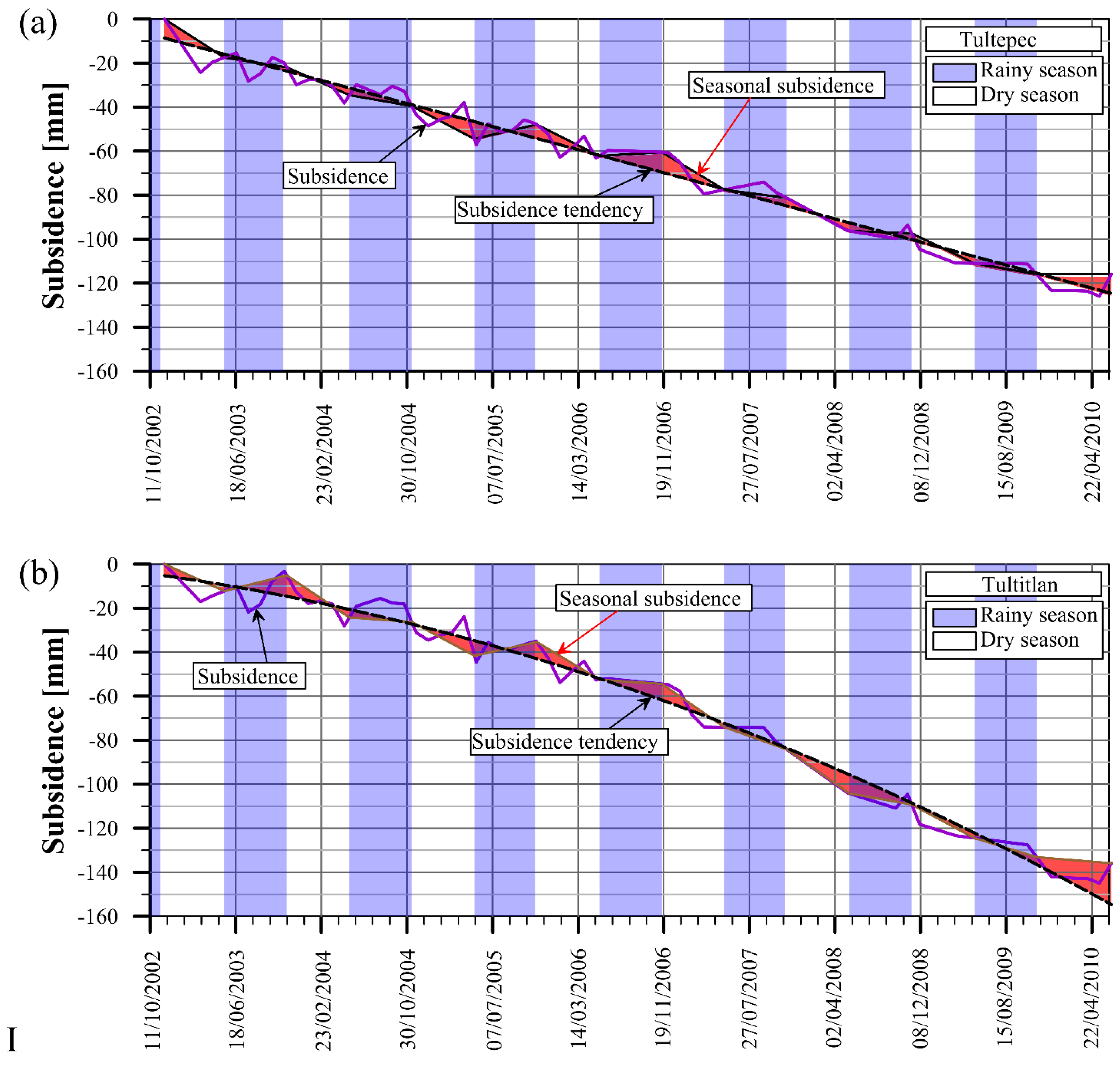
3.2.2. Seasonal Analysis
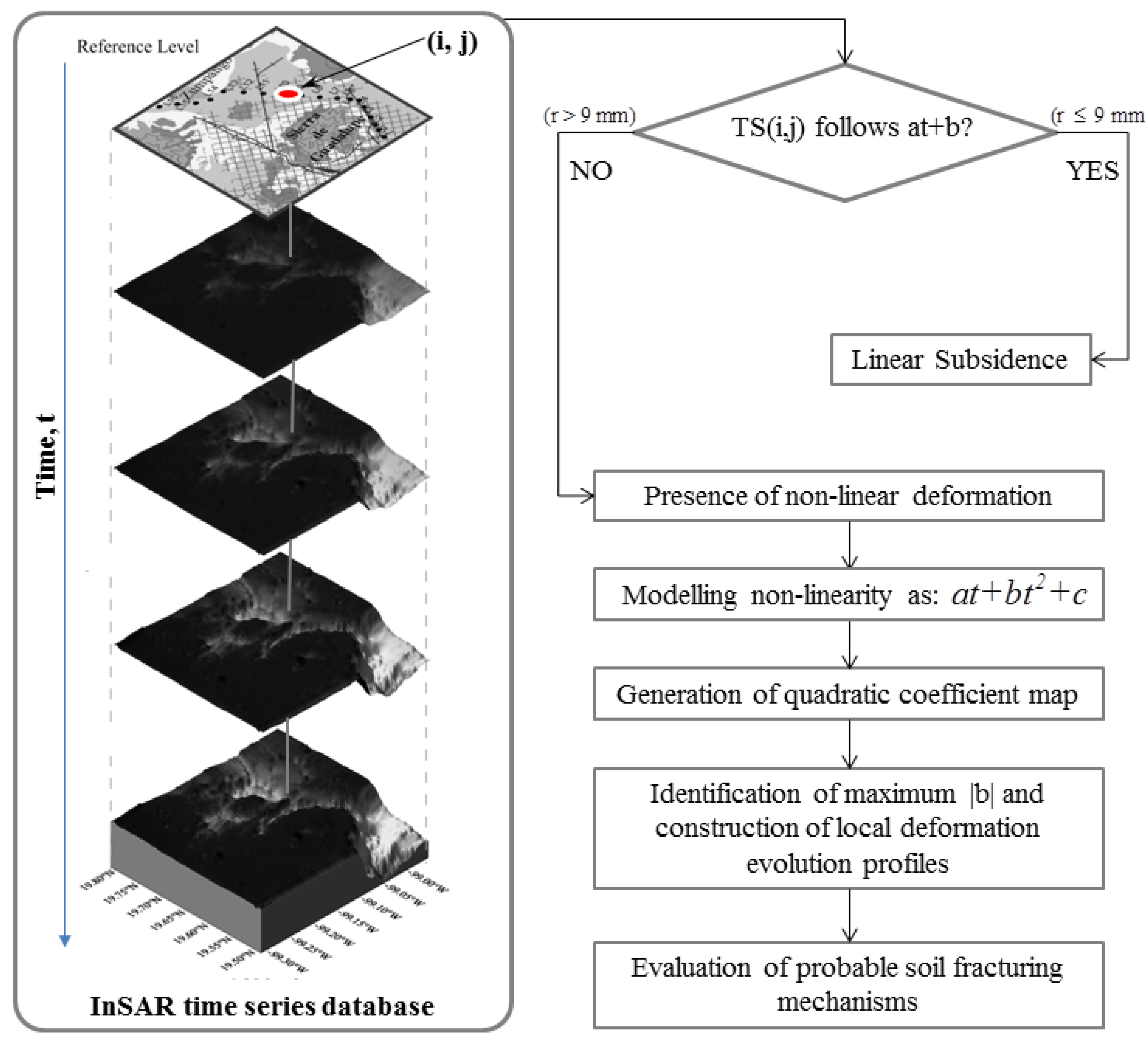
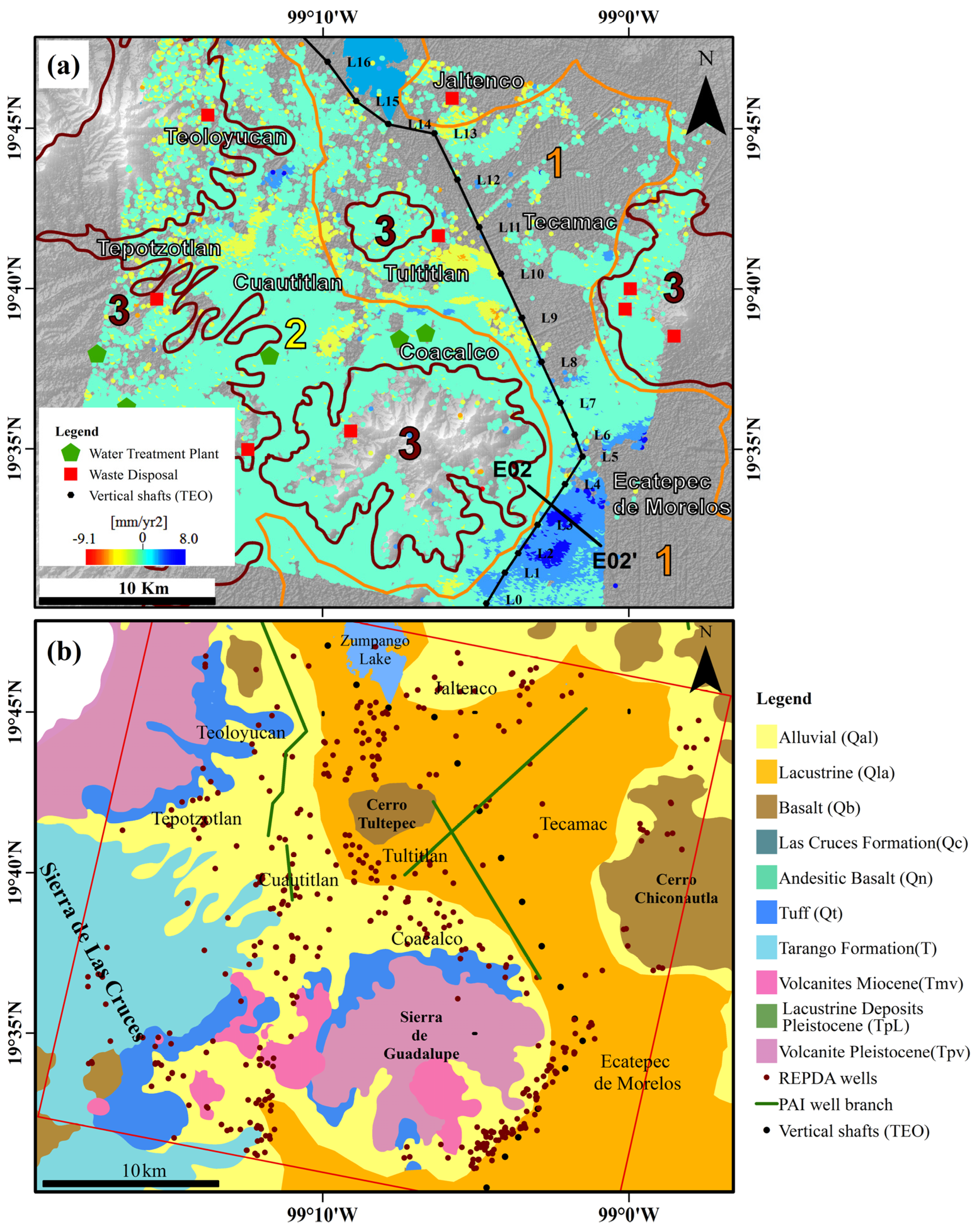
4. Post -Processing Tool for Soil Fracturing Zonation
4.1. Methodology for Fracturing Zonation Based on InSAR Time Series Modelling


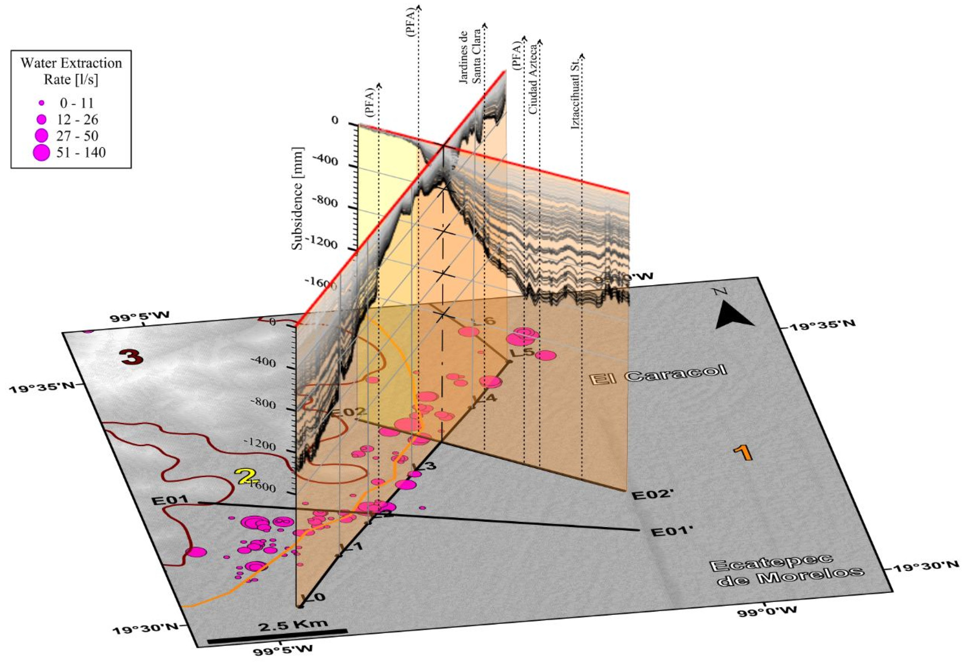
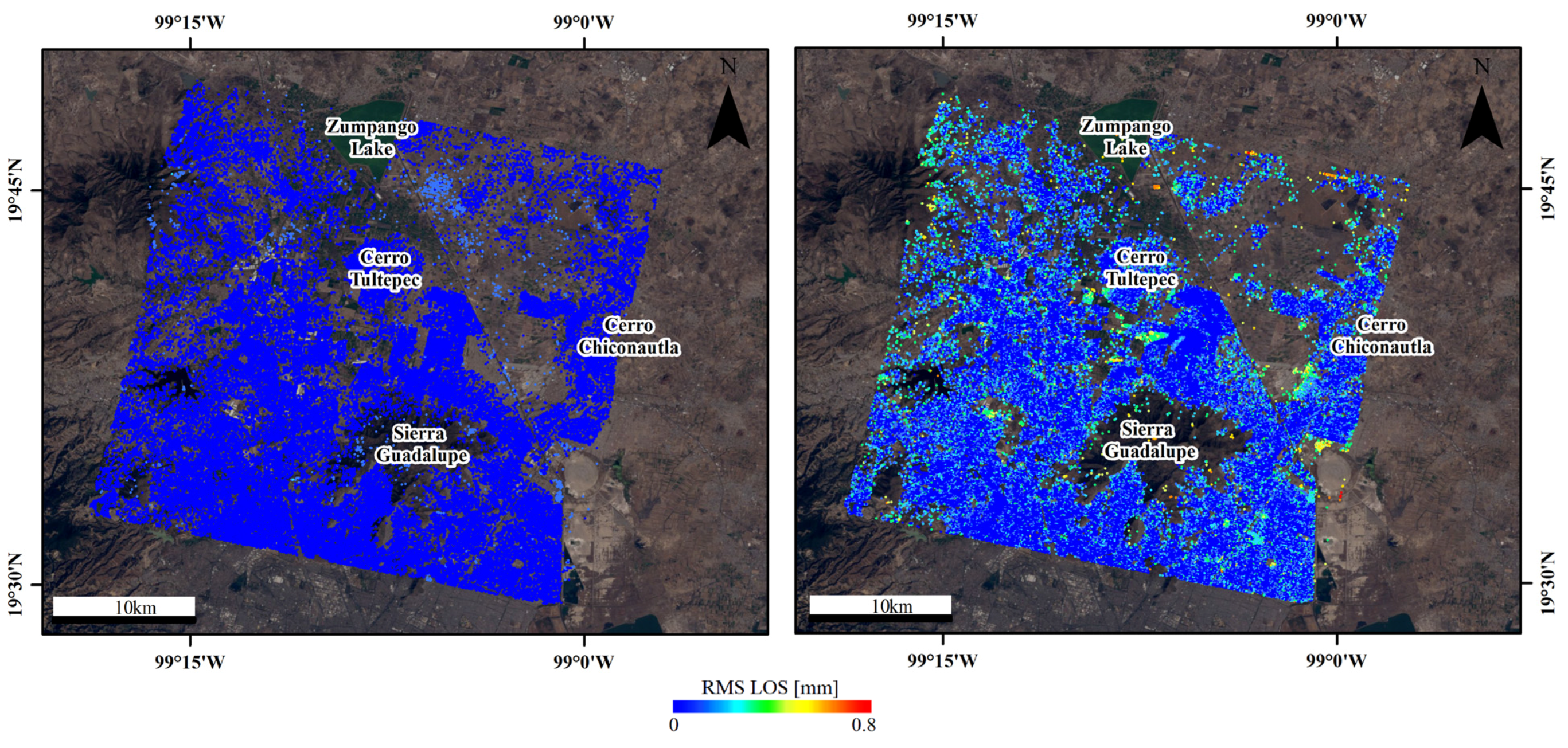
4.2. Soil Fracture-Prone Zones and Impact on Infrastructure

5. Discussion
6. Conclusions
Acknowledgments
Author Contributions
Conflicts of Interest
References
- Ovando-Shelley, E.; Ossa, A.; Santoyo, E. Effects of regional subsidence and earthquakes on architectural monuments in Mexico City. Bol. Soc. Geol. Mex. 2013, 65, 157–167. [Google Scholar]
- Vazquez, S.; Jaimes, P. Geologia de la Cuenca de Mexico. Rev. Geof. Int. 1989, 28, 133–190. [Google Scholar]
- De Cserna, Z.; de la Fuente-Duch, M.; Palacios Nieto, M.; Triay, L.; Mitres Salazar, L.M.; Mota Palomino, R. Estructura Geológica, Gravimetría, Sismicidad y Relaciones Neotectónicas Regionales de la Cuenca de México Boletín 104; Instituto de Geología, UNAM: Mexico City, Mexico, 1988; pp. 23–48. [Google Scholar]
- Marin-Cordova, S.; Campos-Enriquez, O.; Herrera-Moro-Castillo, M. Neotectonic related geological risk at dams in the Mexico Basin: Guadalupe dam. Geof. Int. 2004, 43, 435–443. [Google Scholar]
- Vera Perez, M.; Lopez Blanco, J. Evaluación de amenazas por inundaciones en el centro de México: El caso de Iztapalapa, Distrito Federal (1998–2005). Investig. Geog. 2010, 73, 22–40. [Google Scholar]
- CONAGUA. Acciones de infraestructura de drenaje y abastecimiento de agua en el Valle de México, 2007–2012. Coordinación General de Proyectos Especiales de Abastecimiento de Agua Potable y Saneamiento del Valle de México. Available online: http://www.conagua.gob.mx/conagua07/Noticias/InformeDifusionIngenieriaPSHCVM.pdf (accessed on 19 April 2015).
- Ortega-Guerrero, A.; Rudolph, D.L.; Cherry, J.A. Analysis of long-term land subsidence near Mexico City: Field investigations and predictive modelling. Water Resour. Res. 1999, 35, 3327–3341. [Google Scholar] [CrossRef]
- Figueroa-Vega, G.E. Subsidence of the city of Mexico: A historical review. In Proceedings of the Second International Symposium on Land Subsidence, Anaheim, CA, USA, 13–17 December 1976; pp. 35–38.
- Carreón-Freyre, D.; Cerca, M. Integration of geological properties in the study of the subsidence and fracturing phenomena in two urban areas of Mexico. In Proceedings of the 10th IAEG International Congress, Nottingham, UK, 6–10 September 2006.
- Cabral-Cano, E.; Dixon, T.H.; Miralles-Wilhel, F.; Sanchez-Zamora, O.; Carande, R.E. Space geodetic imaging of rapid ground subsidence in Mexico City. Geol. Soc. Am. Bull. 2008, 120, 1556–1566. [Google Scholar] [CrossRef]
- López-Quiroz, P.; Doin, M.P.; Tupin, F.; Briole, P.; Nicolas, J.M. Time series analysis of Mexico City subsidence constrained by radar interferometry. J. Appl. Geophys. 2009, 69, 1–15. [Google Scholar] [CrossRef]
- Cerca, M.; Carreón-Freyre, D.; López-Quiroz, P.; Ovando-Shelley, E.; Doin, M.P.; Gutierrez-Calderón, R.; González-Hernández, M.; Jimenez-Sánchez, A.; Blancas-Dominguez, D. Engineering geology approach to the effects of land subsidence in Mexico City. Geol. Soc. Am. Field Guid. 2012, 25, 115–133. [Google Scholar]
- Osmanoglu, B.; Dixon, T.H.; Wdowinski, S.; Cabral-Cano, E.; Jiang, Y. Mexico City subsidence observed with persistent scatterer InSAR. Int. J. Appl. Earth Observ. Geoinf. 2010, 13. [Google Scholar] [CrossRef]
- Huizar-Alvarez, R.; Hernandez, G.; Carrillo-Martinez, M.; Carrillo-Rivera, J.J.; Hergt, T.; Ángeles, G. Geologic structure and groundwater flow in the Pachuca-Zumpango sub-basin, central Mexico. Environ. Geol. 2003, 43, 385–399. [Google Scholar]
- Galindo Castillo, E.; Otazo Sánchez, E.M.; Reyes Gutiérrez, L.R.; Arellano Islas, S.M.; Gordillo Martínez, A.; González Ramírez, C.A. Balance hídrico y afectaciones a la recarga para el año 2021 en el acuífero Cuautitlan Pachuca. GeoFocus 2010, 10, 65–90. [Google Scholar]
- Neri-Ramírez, E.; Rubiños-Panta, E.J.; Palacios-Velez, O.L.; Oropeza-Mota, J.L.; Flores-Magdaleno, H.; Ocampo-Fletes, I. Evaluación de la sustentabilidad del acuífero cuautitlán-pachuca mediante el uso de la metodología mesmis. Rev. Chapingo Ser. Cienc. For. Ambient. 2013, 19, 273–285. [Google Scholar]
- Jacobs, A.; Sandwell, D.; Fialko, Y.; Sichoix, L. The 1999 (Mw 7.1) Hector Mine, California, earthquake: Near-Field postseismic deformation from ERS interferometry. Bull. Seism. Soc. Am. 2002, 92, 1433–1442. [Google Scholar] [CrossRef]
- Amelung, F.; Galloway, D.L.; Bell, J.W.; Zebker, H.A.; Laczniak, R.J. Sensing the ups and downs of Las Vegas: InSAR reveals structural control of land subsidence and aquifer-system deformation. Geology 1999, 27, 483–486. [Google Scholar] [CrossRef]
- Kenyi, L.W.; Kaufmann, V. Estimation of alpine permafrost surface deformation using InSAR data. In Proceedings of the 2001 IEEE Geoscience and Remote Sensing Symposium, GARSS 2001, Sydney, Australia, 2–13 July 2001; pp. 1107–1109.
- Bechor, N. Extending Interferometric Synthetic Aperture Radar Measurements from One to Two Dimensions. Ph.D. Thesis, Stanford University, CA, USA, 2006. [Google Scholar]
- Ferretti, A.; Prati, C.; Rocca, F. Permanent scatterers in SAR interferometry. IEEE Trans. Geosci. Remote Sens. 2001, 39, 8–20. [Google Scholar] [CrossRef]
- Hooper, A.; Zebker, H.; Segall, P.; Kampes, B. A new method for measuring deformation on volcanoes and other natural terrains using InSAR persistent scatterers. J. Geophys. Res. 2004, 31. [Google Scholar] [CrossRef]
- Berardino, P.; Fornaro, G.; Lanari, R.; Sansosti, E. A new algorithm for surface deformation monitoring based on Small Baseline Differential SAR Interferograms. IEEE Trans. Geosci. Remote Sens. 2002, 40, 2375–2383. [Google Scholar] [CrossRef]
- Usai, S. A least squares database approach for SAR interferometric data. IEEE Trans. Geosci. Remote Sens. 2003, 41, 753–760. [Google Scholar] [CrossRef]
- Hooper, A. A multi-temporal InSAR method incorporating both persistent scatterer and small baseline approaches. Geophys. Res. Lett. 2008, 35. [Google Scholar] [CrossRef]
- Siles, G.; Niemeier, W.; Lopez-Quiroz, P. Interrelations between ground-water extraction, construction activities and ground subsidence in Valley of Mexico. In Proceedings of GeoMonitoring Tagung 2015, Clausthal-Zellerfeld, Germany, 5–6 March 2015; pp. 93–104.
- CONAPO. Delimitación De Las Zonas Metropolitanas De México 2010, Mexico. Available online: http://www.conapo.gob.mx/es/CONAPO/Zonas_metropolitanas_2010 (accessed on 14 April 2014).
- Gómez-Reyes, E. Valoración de las componentes del balance hídrico usando información estadística y geográfica: La cuenca del Valle de México. Realidad, datos y espacio. Rev. Int. Estad. Geogr. 2013, 4, 4–28. [Google Scholar]
- Rosen, P.A.; Hensley, S.; Peltzer, G.; Simons, M. Updated repeat orbit interferometry package released. EOS Trans. Am. Geophys. Union 2004, 85, 47. [Google Scholar] [CrossRef]
- Kampes, B.M.; Hanssen, R.F.; Perski, Z. Radar interferometry with public domain tools. In Proceedings of the FRINGE 2003 Workshop, Frascati, Italy, 1–3 December 2003.
- Scharroo, R.; Visser, P.N.A.M.; Mets, G.J. Precise orbit determination and gravity field improvement for the ERS satellites. J. Geophys. Res. 1998, 103, 8113–8127. [Google Scholar] [CrossRef]
- Farr, T.G.; Rosen, P.A.; Caro, E.; Crippen, R.; Duren, R.; Hensley, S.; Kobrick, M.; Paller, M.; Rodriguez, E.; Roth, L.; et al. The shuttle radar topography mission. Rev. Geophys. 2007, 45. [Google Scholar] [CrossRef]
- Crosetto, M.; Arnaud, A.; Duro, J.; Biescas, E.; Agudo, M. Deformation monitoring using remotely sensed radar interferometric data. In Proceedings of the 11th International FIG Symposium on Deformation Measurements, Santorini (Thera) Island, Greece, 25–28 May 2003.
- Werner, C.; Wegmuller, U.; Strozzi, T.; Wiesmann, A. Interferometric point target analysis for deformation mapping. In Proceedings of the 2003 IEEE International Geoscience and Remote Sensing Symposium, IGARSS 2003, Toulouse, France, 21–25 July 2003; pp. 4362–4364.
- Kampes, B.M. Displacement Parameter Estimation Using Permanent Scatterer Interferometry. Ph.D Thesis, Delft University of Technology, Delft, The Netherlands, 2005. [Google Scholar]
- Hooper, A. A statistical-cost approach to unwrapping the phase of InSAR time series. In Proceedings of the Advances in the Science and Applications of SAR Interferometry, ESA Fringe 2009, Workshop ESA, Frascati, Italy, 30 November–4 December 2009.
- Chen, C.; Zebker, H. Phase unwrapping for large SAR interferograms: Statistical segmentation and generalized network models. IEEE Trans. Geosci. Remote Sens. 2002, 40, 1709–1719. [Google Scholar] [CrossRef]
- Shanker, P.; Zebker, H. Edgelist phase unwrapping algorithm for time series InSAR analysis. J. Opt. Soc. Am. 2010, 27, 605–612. [Google Scholar] [CrossRef] [PubMed]
- Cavalié, O.; Doin, M.P.; Lasserre, C.; Briole, P. Ground motion measurement in the Lake Mead area, Nevada, by differential synthetic aperture radar interferometry time series analysis: Probing the lithosphere rheological structure. J. Geophys. Res. 2007, 112. [Google Scholar] [CrossRef]
- Chaussard, E.; Wdowinski, S.; Cabral-Cano, E.; Amelung, F. Land subsidence in central Mexico detected by ALOS InSAR. Remote Sens. Environ. 2014, 140, 94–106. [Google Scholar] [CrossRef]
- Estrada Domínguez, F. Enciclopedia de Los Municipios y Delegaciones de México, Jaltenco. 2010. Available online: http://www.inafed.gob.mx/work/enciclopedia/EMM15mexico/index.html (accessed on 20 March 2014).
- Vargas, G.N. Enciclopedia de Los Municipios y Delegaciones de México. Estado de Mexico. Tepotzotlán. 2014. Available online: http://www.inafed.gob.mx/work/enciclopedia/EMM15mexico/municipios/15095a.html (accessed on 15 February 2014).
- INEGI. Estadísticas del Medio Ambiente del Distrito Federal y Zona Metropolitana 2002. 2005. Available online: http://www.inegi.gob.mx/prod_serv/contenidos/espanol/bvinegi/productos/integracion/sociodemografico/medioambdf/2002/archivo1.pdf (accessed on 23 March 2014).
- Dirección General de Proteccion Civil; Ayuntamiento de Tultepec. Altas de Riesgo 2013–2015. Available online: http://www.tultepec.gob.mx/pdf/ATLAS_TULTEPEC.pdf (accessed on 18 March 2014).
- Ayuntamiento de Tutitlán. Plan de Desarrollo Municipal 2006–2009. Available online: http://ordenjuridicodemo.segob.gob.mx/Estatal/ESTADO%20DE%20MEXICO/Municipios/Tultitlan/Plan01.pdf (accessed on 20 September 2013).
- Cerca, M.; Carreón-Freyre, D.; Gutierrez, R. Instability of the urbanized flank of el peñón del marques volcanic edifice and its relation to land subsidence in Mexico City. In Proceedings of the Eighth International Symposium on Land Subsidence (EISOLS) 2010, Querétaro, Mexico, 17–22 October 2010; pp. 44–50.
- Carreón-Freyre, D.; Cerca, M. Delineating the near-surface geometry of the fracture system affecting the valley of Queretaro, Mexico: Correlation of GPR signatures and physical properties of sediments. Near Surf. Geophys. 2006, 4, 49–55. [Google Scholar] [CrossRef]
- Cabral-Cano, J.E.; Arciniega-Ceballos, A.; Díaz-Molina, O.; Cigna, F.; Ávila-Olivera, A.; Osmanoglu, B.; Dixon, T.; Demets, C.; Garuño-Monroy, V.H.; Vergara-Huerta, F.; et al. Is there a tectonic component to the subsidence process in Morelia, Mexico? In Proceedings of the Eighth International Symposium on Land Subsidence (EISOLS) 2010, Querétaro, Mexico, 17–22 October 2010; pp. 164–169.
- Barajas-Nigoche, L.D.; Carreón-Freyre, D.C.; Mata-Segura, J.L.; Rivera-León, A.; Cafaggi-Félix, F. Geological and geophysical characterization of fracturing in granular deposits associated with land subsidence in San Luis Potosí City, Mexico. In Proceedings of the Eighth International Symposium on Land Subsidence (EISOLS) 2010, Querétaro, Mexico, 17–22 October; pp. 201–206.
- Auvinet, G.; Méndez, E.; Juárez, M. Soil fracturing induced by land subsidence in Mexico City. In Proceedings of the 18th International Conference on Soil Mechanics and Geotechnical Engineering, Paris, France, 2–6 September 2013.
- Cigna, F.; Del Ventisette, C.; Liguori, V.; Casagli, N. Advanced radar-interpretation of InSAR time series for mapping and characterization of geological processes. Nat. Hazards Earth Syst. Sci. 2011, 11, 865–881. [Google Scholar] [CrossRef]
- Ishitsuka, K.; Fukushima, Y.; Tsuji, T.; Yamada, Y.; Matsuoka, T.; Giao, P.H. Natural surface rebound of the Bangkok plain and aquifer characterization by persistent scatterer interferometry. Geochem. Geophys. Geosyst. 2014, 15, 965–974. [Google Scholar] [CrossRef]
- Kim, S.; Wdowinski, S.; Dixon, T.H.; Amelung, F.; Kim, J.W.; Won, J. Measurements and predictions of subsidence induced by soil consolidation using persistent scatterer InSAR and a hyperbolic model. Geophys. Res. Lett. 2010, 37. [Google Scholar] [CrossRef]
- López-Quiroz, P.; Doin, M.P.; Tupin, F.; Briole, P.; Nicolas, J.M. Mexico City subsidence analysis assisted by InSAR. In Proceedings of the Eighth International Symposium on Land Subsidence (EISOLS) 2010, Querétaro, Mexico, 17–22 October 2010; pp. 304–306.
- Gobierno del Estado de México; Ayuntamiento del Tecámac. Atlas de Riesgos Tecamac. Available online: http://www.google.de/url?sa=t&rct=j&q=&esrc=s&source=web&cd=1&ved=0CCMQFjAA&url=http%3A%2F%2Fwww.ipomex.org.mx%2Fipo%2Farchivos%2FdownloadAttach%2F303480.web%3Bjsessionid%3D7A8471EEF7CBED68D77A1017BE2E44B8&ei=UEAPVOGsDKW7ygPR74LADA&usg=AFQjCNG6D5Y9fgkrgvRbVbOrJnqnnIBUIA&sig2=1I2Sn1Y_zL0Mq16-_RUuZQ&bvm=bv.74649129,d.bGQ (accessed on 25 February 2014).
- Instituto de Proteccion Civil. Fracturamientos Recientes En Los Municipios Del Estado de Mexico, Cuaderno De Investigación. 2004. Available online: http://portal2.edomex.gob.mx/dgproteccion_civil/prevencion/prevencion/cultura_proteccion_civil/trabajos_investigacion/groups/public/documents/edomex_archivo/dgproteccion_civil_pdf_ci4.pdf (accessed on 25 November 2013).
- Auvinet, G. Soil fracturing induced by land subsidence. In Proceedings of the Eighth International Symposium on Land Subsidence (EISOLS), Querétaro, Mexico, 17–22 October 2010; pp. 20–26.
- Méndez, E.; Auvinet, G.; Lermo, J. Avances en la Caracterización Geotécnica del Agrietamiento del Subsuelo de la Cuenca de México. Available online: http://www.geofisica.unam.mx/sismologia/app/webroot/files/ssn/1-SI-35-20110811160217-Auvinet.pdf (accessed on 28 January 2014).
- Carrera-Hernandez, J.J.; Gaskin, S.J. The Basin of Mexico aquifer system: Regional groundwater level dynamics and database development. Hydrogeol. J. 2007, 15, 1577–1590. [Google Scholar] [CrossRef]
- Ayuntamiento de Teoloyucan. Plan Municipal de Desarrollo de Teoloyucan. Available online: http://portal2.edomex.gob.mx/sedur/planes_de_desarrollo/planes_municipales/teoloyucan/index.htm (accessed on 5 February 2014).
- Ayuntamiento de Tepotzotlán; Gobierno del Estado de México. Plan municipal de Desarrollo Urbano de Tepotzotlán. Available online: http://seduv.edomexico.gob.mx/planes_municipales/Tepotzontlan/tepotzotlan%20mayo%202003.pdf (accessed on 5 January 2014).
- Gobierno del Estado de Mexico. CAEM, Atlas de Inundaciones No.17. Municipio Ecatepec de Morelos. 2010. Available online: http://qacontent.edomex.gob.mx/idc/groups/public/documents/edomex_archivo/caem_pdf_vmatlasxviiecatepec.pdf (accessed on 15 February 2014).
- Salinas, J.; Nuñez, M. Ecatepec: 520 Viviendas Dañadas y ocho Destruidas por la Tormenta. 2009. Available online: http://www.jornada.unam.mx/2009/11/02/estados/025n1est (accessed on 15 January 2014).
- Ayuntamiento Constitucional de Coacalco de Berriozabal. Plan de Desarrollo Municipal 2003–2006. Available online: http://www.ordenjuridico.gob.mx/Estatal/ESTADO%20DE%20MEXICO/Municipios/Coacalco%20de%20Berriozabal/COAPla1.pdf (accessed on 15 September 2013).
- Salinas Cesareo, J. Hundimiento en Coacalco Pone en Peligro las Viviendas de 15 Familias. 2007. Available online: http://www.jornada.unam.mx/2007/04/14/index.php?section=estados&article=028n1est (accessed on 26 November 2013).
- Salinas Cesareo, J. Alerta en Jaltenco, Edomex, por Grieta de 3 Kilómetros en el Subsuelo. 2007. Available online: http://www.jornada.unam.mx/2007/07/14/index.php?section=estados&article=028n1est (accessed on 8 January 2014).
- Pacheco-Martínez, J.; Arzate-Flores, J. Multilayered analysis of subsidence in the valley of Queretaro, Mexico. Rev. Mex. Cienc. Geol. 2007, 24, 389–402. [Google Scholar]
- Carreón-Freyre, D.; Cerca, M.; Ochoa-Gonzales, H.; Ortiz-Villasenor, I.; Gámez-Gonzales, J.; Gutierrez-Calderón, R. Land Subsidence and ground fracturing affecting major cities of Central Mexico and related groundwater management. In Proceedings of the 14th Pan-American Conference on Soil Mechanics and Geotechnical Engineering, Toronto, ON, Canada, 2–6 October 2011.
- Ovando-Shelley, E.; Lermo-Samaniego, J.; Auvinet, G.; Méndez-Sanchez, E. Microtremor measurements to identify zones of potential fissuring in the basin of Mexico. Geof. Int. 2012, 51–52, 143–156. [Google Scholar]
- Ayuntamiento de Ecatepec de Morelos. Plan de Desarrollo Municipal 2009–2012. Available online: http://www.ecatepec.gob.mx/transparencia/docs/Plan_de_Desarrollo_Municipal.pdf (accessed on 20 March 2013).
- Auvinet, G.; Juárez, M. Geotechnical characterization of Mexico City subsoil. In Proceedings of the 14th Pan-American Conference on Soil Mechanics and Geotechnical Engineering, Toronto, ON, Canada, 2–6 October 2011.
- Juárez Camarena, M.; Auvinet Guichard, G.; Hernández Vizcarra, F.; Méndez Sánchez, E. Contribution to the geotechnical characterization of the subsoil of the North of Mexico Basin. In Proceedings of the XXV Reunión Nacional de Mecánica de Suelos e Ingeniería Geotécnica, Acapulco, Mexico, 10–13 November 2010; pp. 333–343.
- Salvador, F. Temen Habitantes por Hundimiento de Calle. 2009. Available online: http://www.especialistas.com.mx/saiweb/viewer.aspx?file=c8u0JHolyPzScjDD09MU1fsioM/OWrRZycFj6X4VsRjE1pLGJZISOdylwhYi8u6A&opcion=0&encrip=1 (accessed on 20 March 2014).
- Gobierno del Estado de Mexico; Secretaria de Desarrollo Urbano y Vivienda. Plan Municipal de Desarrollo Urbano de Ecatepec. Available online: http://www.ecatepec.gob.mx/transparencia/Plan%20de%20Desarrollo%20Urbano%202003.pdf (accessed on 15 September 2013).
- Salinas, J. A Punto del Colapso, Cientos de Casas en Ecatepec; Tienen Daños Severos. 2006. Available online: http://www.jornada.unam.mx/2006/01/03/index.php?section=estados&article=027n1est (accessed on 25 November 2013).
- Gobierno del Distrito Federal. Reglamento de Construcciones para el Distrito Federal. 2004. Available online: http://centro.paot.org.mx/centro/reglamentos/df/pdf/REGLAMENTOS_DF_PDF/RGTO_CONSTRUCCIONES_29_01_2004.pdf (accessed on 8 September 2014). [Google Scholar]
- Cabral-Cano, E.; Molina, O.D.; Delgado Granados, H. Subsidencia y sus mapas de peligro: Un ejemplo en el área nororiental de la Zona Metropolitana de la Ciudad de México. Bol. Soc. Geol. Mex. 2011, 63, 53–60. [Google Scholar]
- Cigna, F.; Osmanoğlu, B.; Cabral-Cano, E.; Dixon, T.H.; Ávila-Olivera, J.A.; Garduño-Monroy, V.H.; DeMets, C.; Wdowinski, S. Monitoring land subsidence and its induced geological hazard with Synthetic Aperture Radar Interferometry: A case study in Morelia, Mexico. Remote Sens. Environ. 2012, 117, 146–161. [Google Scholar] [CrossRef]
- INEGI. Mapa Digital de Mexico. Available online: http://www.inegi.org.mx (accessed on 7 September 2013).
- Servicio Sismologico Nacional (SSN). Catalgo. Available online: http://www.ssn.unam.mx/ (accessed on 20 November 2013).
- Núñez López, M.A. Daños en Escuelas y Edificios de Tultitlán a consecuencia del Pasado Sismo. 2012. Available online: http://cronistadetultitlan.blogspot.de/2012/03/danos-en-escuelas-y-edificios-de.html (accessed on 3 April 2014).
- Zeevaert, L. Consolidation in the Intergranular Viscosity of Highly Compressible Soils. In Testing and Evaluation ASTM STP 892; Yong, N.R., Towsend, F.C., Eds.; American Society for Testing and Materials: Philadelphia, PA, USA, 1986; pp. 287–281. [Google Scholar]
- Philor, L. Erosion Impacts on Soil and Environmental Quality: Vertisols in the Highlands Region of Ethiopia. Available online: http://soils.ifas.ufl.edu/docs/pdf/academic/papers/Philor-Louis.pdf (accessed on 7 March 2014).
© 2015 by the authors; licensee MDPI, Basel, Switzerland. This article is an open access article distributed under the terms and conditions of the Creative Commons Attribution license (http://creativecommons.org/licenses/by/4.0/).
Share and Cite
Siles, G.L.; Alcérreca-Huerta, J.C.; López-Quiroz, P.; Niemeier, W. Long Term Subsidence Analysis and Soil Fracturing Zonation Based on InSAR Time Series Modelling in Northern Zona Metropolitana del Valle de Mexico. Remote Sens. 2015, 7, 6908-6931. https://doi.org/10.3390/rs70606908
Siles GL, Alcérreca-Huerta JC, López-Quiroz P, Niemeier W. Long Term Subsidence Analysis and Soil Fracturing Zonation Based on InSAR Time Series Modelling in Northern Zona Metropolitana del Valle de Mexico. Remote Sensing. 2015; 7(6):6908-6931. https://doi.org/10.3390/rs70606908
Chicago/Turabian StyleSiles, Gabriela Llanet, Juan Carlos Alcérreca-Huerta, Penélope López-Quiroz, and Wolfgang Niemeier. 2015. "Long Term Subsidence Analysis and Soil Fracturing Zonation Based on InSAR Time Series Modelling in Northern Zona Metropolitana del Valle de Mexico" Remote Sensing 7, no. 6: 6908-6931. https://doi.org/10.3390/rs70606908
APA StyleSiles, G. L., Alcérreca-Huerta, J. C., López-Quiroz, P., & Niemeier, W. (2015). Long Term Subsidence Analysis and Soil Fracturing Zonation Based on InSAR Time Series Modelling in Northern Zona Metropolitana del Valle de Mexico. Remote Sensing, 7(6), 6908-6931. https://doi.org/10.3390/rs70606908