Abstract
In China, the Lower Jingjiang Reach (LJR) of the Yangtze River could be one of the most complicated areas in terms of channel migration. The river had undergone many channel changes in the reach since the 18th century. Intensive human activities in recent decades, such as the construction of upstream dams and revetments, had directly affected the channel migration characteristics. The revetment would significantly diminish migration, whereas the reduced sediment caused by dams would increase bank erosion and bank failure risks. Satellite imageries of Landsat Multi Spectral Scanner (MSS), Thematic Mapper (TM), Enhanced Thematic Mapper Plus (ETM+) and Operational Land Imager (OLI) were employed to quantify the planform migration of the reach from 1983 to 2013 and to investigate the possible effect of human activities on the LJR channel evolution. Apart from the commonly used planform morphometric parameters, the migration direction was introduced to predict the future migration trends. Results showed that the LJR was gradually changing to a straighter channel, with sinuosity reducing from 2.09 to 1.9 and river length decreasing from 125.32 km to 113.31 km in the past 30 years. Planform morphometric parameters, such as migration rate of the channel centerline and erosion and deposition areas and rates, also decreased drastically in the past 30 years. The migration rate of the channel centerline decreased from 31.05 m·year−1 in 1983–1988 to 11.62 m·year−1 in 2009–2013. The lateral erosion and deposition areas decreased from 21.32 and 25.73 km2 in 1983–1988 to 4.83 and 5.83 km2 in 2009–2013. All of these findings indicate that the LJR tended to be in a steady state from 1983 to 2013 and was totally controlled by the bank revetments. However, the undercutting was strengthened because of the restrictive effect of revetments on lateral migration in the LJR. Moreover, the channel migrated to the left bank with a visible tendency as the total migration area to the left bank was approximately two times that of the right bank during the period. Consequently, the left bank of the LJR should be the focus of more attention in future migrations, and bank revetments of the left bank should be kept reinforced and adjusted with the change of water and sediment conditions.
Keywords:
remote sensing; river channel; lateral migration; planform; dynamic change; bank revetment 1. Introduction
The dynamic change of river channels over time has been a major focus of study in geomorphology [1]. Various techniques, such as sedimentological and botanical evidence, historical sources, planimetric resurvey, repeated cross-profiling, erosion pins and terrestrial photogrammetry, have been used to measure riverbank erosion and channel change [2]. According to the data sources used, the approaches can be divided into four major categories, namely, field survey, remote sensing, historical and palaeo. Each of these approaches has its strengths and weaknesses in terms of its scale, accuracy, availability and repeatability in characterizing river channel change [3]. Compared with other techniques, remotely sensed data provide a direct, comprehensive and synoptic perspective of large areas periodically. This technique is quite different from traditional approaches (e.g., cross-sections, historical maps and sedimentology), which are generally localized in extent [4]. As an accurate, cost-effective, multi-spectral and multi-temporal source of information, remote sensing has been extensively utilized to assess planform morphology change in many river basins. Morphometric parameters, such as channel width [5,6], water surface area [7] and sinuosity [8], were calculated in several studies to evaluate the migration of channel planform morphology. Bank erosion and deposition [9,10], channel pattern identification [11,12], bank line and centerline shift [13] and channel change caused by human intervention [14,15] have been investigated on the basis of remotely sensed data.
Compared with site survey observation, remotely sensed images can provide an instantaneous “snapshot” of river channels. Thus, the boundary of extracted water surface area could be defined as the riverbank line in theory. However, the extracted water boundary was sensitive to the concurrent water level variations, and the channel changes derived from satellite images with the concurrent water level in different value ranges could vary. A low water level could cause considerable exposure of the river bed that would lead to errors in the extracted channel compared with that in a high water level [11]. Only satellite images with the least possible water level differences could be selected to decrease the errors. At present, errors of channel dynamic comparison caused by water level variations can be easily recognized. The images with minimal water level differences and maximal time intervals were selected among all the available images [16]. Images acquired in the low water season were recommended for use in detecting fluvial dynamics [17]. Although the concurrent water levels in the acquired dates were used as the image selection criterion to diminish the comparison error, the representativeness of water level in the acquired date of satellite imagery was often ignored.
The Lower Jingjiang Reach (LJR) of the Yangtze River is one of the most frequently changed channels in China [18,19]. After the construction of Three Gorges Dam (TGD), concern about this channel has grown because its geomorphic responses to the dam are complex, variable and difficult to explain through prediction. Most studies utilized the hydrological model, historical map and field survey methods to analyze the hydrological regime change in the LJR. These studies mainly focused on certain aspects, such as the flow and sediment [20,21,22,23], bank erosion and stability [24,25], river channel pattern [19,26] and hydrological effect between rivers and lakes [27,28]. The annual average sediment load at Yichang and Jianli stations in the post-dam period (2003–2007) was reduced by 74% and 84%, respectively, compared with the pre-dam period (1950–1988) [29]. The drastic decrease in sediment load leads to severe and prevalent channel scouring downstream of the dam. According to the survey data of the Changjiang Water Resources Commission [30], the scoured sediment in the low water channel of LJR was 2.53 × 10⁸ m3, which accounts for 81.6% in the bankfull channel (3.1× 10⁸ m3) in 2002–2013. The annual average scoured sediment in the low water channel in 2002–2013 was 0.23 × 10⁸ m3/a, approximately 10 times that in 1957–2002 [31]. The maximum scour depth was 12.7 m at Shishou Reach [32]. The aggravated erosion in the LJR would speed up channel migration in theory. However, the planform change and lateral migration in the LJR were seldom considered. In addition, the migration of the LJR leaves rich deposits and creates fertile land in the floodplain. In contrast, the meandering process also results in the floods, which is the most devastating disaster to the local people. Great floods, such as the flood that occurred in 1998 in the Yangtze River, have threatened millions of human lives in Jingjiang area [33,34]. With the rapid increase in the population in this area, the national and local authorities have a strong desire to construct levees against floods [35]. In this case, the well-known Jingjiang Great Levee and several bank revetments have been constructed along the river, which restricted the migration of the river channel. To date, considerable attention was focused on this channel because it has been in continuous lateral migration with an evident meandering pattern during the past 200 years [26,36]. The hydrology and sediment dynamics of the LJR have been significantly modified after the cutoff of Gezhouba Dam and impoundment of Three Gorges Reservoir in the past three decades. Two national nature reserves (David’s Deer and River Dolphin National Nature Reserve) are also present in this region. The migration of the river channel also has an important influence on the habitats of the two endangered species in the reserves.
Parameters of trajectory analysis to depict channel dynamics includes plan form characteristics (average width and length, water surface area, sinuosity) and channel migration parameters (channel migration area and rate, shift direction, lateral erosion and deposition area and rate). The former were directly measured parameters from the maps and the latter were derived parameters according to the migration analysis between two periods. As an important channel migration parameter, shifting direction of the river channel is often ignored that could provide guidance for targeted riverbank protection plans and ensure the safety of navigation. The study aims to quantify planform morphological changes especially the shift direction in LJR using remote sensing and can finally give some guidance in preventing bank failure, ensuring safety of navigation, regulating river channels and so on.
2. Study Area
The LJR is a section of the Yangtze River. As the longest river in China and the third longest river in the world, the Yangtze River originates from Dangla Mountain Range and is more than 6300 km in length and has a catchment area of 1.94 million km2. The Yangtze River is commonly divided into three reaches, namely, the upper, middle and lower reaches [29]. LJR is located the middle reach of the river and surrounded by extensive floodplains. LJR area enjoys a subtropical monsoon climate and the mean annual temperatures range from 15 to 19 °C and the average annual rainfall is 1000 mm/year [37]. Channel migration easily occurs in meandering rivers, such as the LJR, which are characterized by wide and flat valley floors [13]. A frequent migration pattern was formed during the Qing Dynasty (1820) in the LJR [36]. Considering its approximately 200 year meander morphodynamics, the LJR created a series of oxbow lakes and abandoned meanders after several cutoff processes [21]. These cutoff processes stabilized the migration of the river channel and resulted in tremendous siltation in the river channel of its downstream, bypasses and interior lakes [38]. Many channel migrations have taken place in this river reach for centuries, particularly after several major natural or artificial cutoffs that occurred during the past 50 years [19,26]. The recent strong erosion and scour in the LJR has become the focus of growing concern [22,39]. The construction of the TGD (Figure 1), which is located in the upper stream approximately 300 km from the LJR, was often blamed for the increase in erosion.
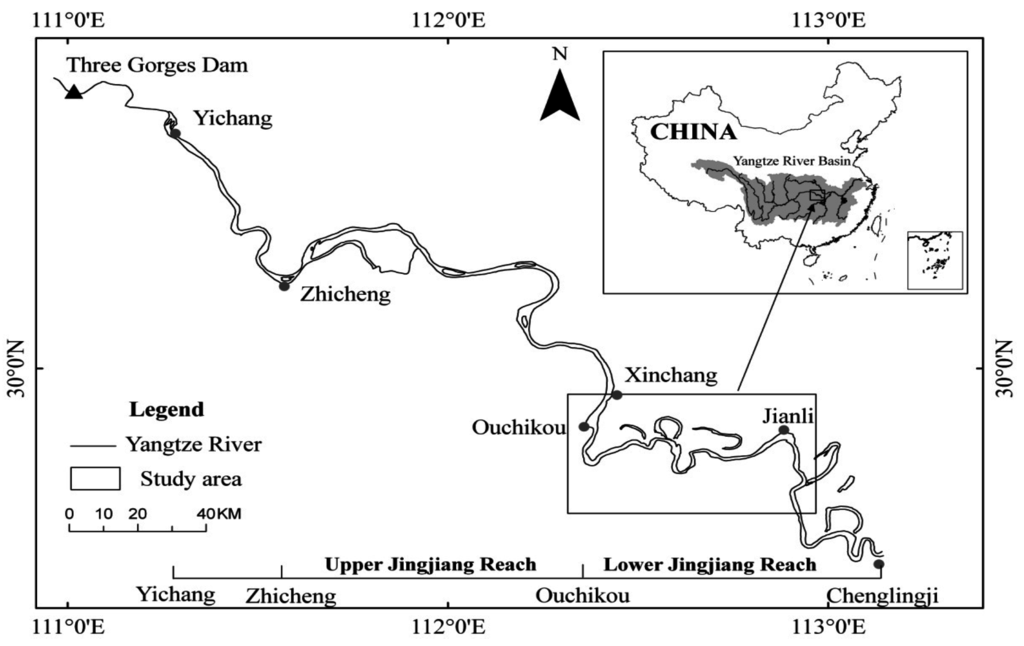
Figure 1.
Location of the study area in the Yangtze River and in China.
3. Data and Methods
The remote sensing method has been extensively utilized to monitor river channel changes. The daily water level data during 1983–2013 was used to select the Landsat satellite images. And the occurrence frequency of water level was analyzed to reduce the comparison errors and to improve the representativeness of the results. The normalized difference water index (NDWI) threshold approach was used to extract the bank line from the images. Then, the channel planform characteristics, including average width and length, water surface area and sinuosity were proposed to examine the planform change characteristics. The channel migration parameters, including lateral erosion, lateral deposition and trend of the shifting direction of the channel were also proposed and applied to quantify the spatial difference of channel migration in the LJR during the period of 1983–2013. Finally, the migration pattern and its future trends were summarized on the basis of the channel change trajectories.
3.1. Water Level Frequency Analysis and Satellite Imagery Selection
Remote sensing approaches mainly used bank line information to depict river migration. The water level fluctuation could affect the results of bank line extracted from the images acquired in different dates. To ensure the representative of extracted results, water level frequency was analyzed. The frequency histogram of water level was derived and the interval with the maximum frequency was defined as the representative water level to ensure the representativeness of bank line extracted from satellite imageries. Only the cloud-free satellite imageries with the concurrent water level falling in the representative water level interval were selected for further river migration comparison. The daily water level data from Jianli gauging station in the middle Yangtze River were utilized in the current study. The time series of data covered the period from January 1983 to December 2013. The lowest water level is 22.72 m and the highest water level is 38.27 m over the period. Then, the range between the highest and lowest water levels was divided into 16 classes with 1 m interval. The result showed that the water level occurrence frequency between 24.5 m and 25.5 m is the highest, accounting for 16% of all the classes (Figure 2). Therefore, the representative water level interval was set as between 24.5 m and 25.5 m.
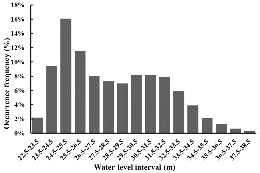
Figure 2.
Water level frequency of Jianli gauging station during the period of 1983–2013.
According to the representative water level interval, the corresponding satellite imagery of Landsat MSS (1983), TM (1988, 1995 and 2009), ETM+ (2002) and OLI (2013) bands were selected to investigate river migration in the study region between 1983 and 2013 (Table 1). All satellite imageries used in this study were obtained from the United Stated Geological Survey (http://earthexplorer.usgs.gov/). The strategy for geometric correction was image-to-image registration, with the image in 2009 as the reference of all other images. The root mean square errors of correction are all less than 30 m.

Table 1.
Characteristics of the selected satellite images.
| No. | Acquisition Date | Water Level (m) | Image Type | Spatial Resolution(m) |
|---|---|---|---|---|
| 1 | 8 Febraury 1983 | 25.44 | Landsat-MSS | 60 |
| 2 | 28 April 1988 | 25.52 | Landsat-TM5 | 30 |
| 3 | 28 December 1995 | 24.53 | Landsat-TM5 | 30 |
| 4 | 5 January 2002 | 24.74 | Landsat-ETM+ | 30 |
| 5 | 16 January 2009 | 24.93 | Landsat-TM5 | 30 |
| 6 | 29 December 2013 | 24.96 | Landsat-OLI | 30 |
3.2. Bank Line Extraction
Although the classification, density slicing and NDWI approaches are all convenient and effective methods to delineate water areas [40], NDWI always produced the best results compared with the other approaches [41]. The NDWI used in the study was developed by McFeeters (1996) [42]. The NDWI is expressed as follows:
where Green and NIR represent the reflectance in the green and near infrared bands, respectively.
The water body was extracted by using the threshold method based on the NDWI values (Figure 3). The boundary of the water body was used as the bank line, and the water surface shown in the images was assumed to be the river channel. The max water surface area was defined as the maximum region of the water that the area could reach between 1983 and 2013. It is the union of the water surface areas in the six images.
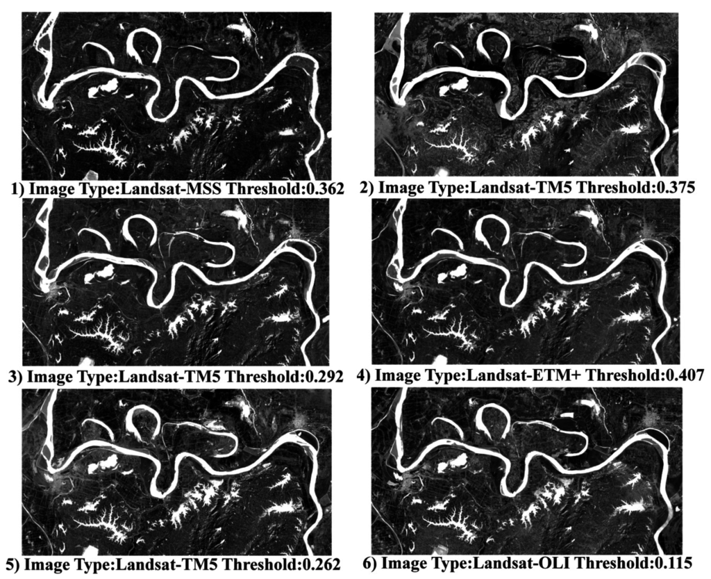
Figure 3.
NDWI images of the LJR and the corresponding threshold. Sub-figures 1–6 means the NDWI images in 1983, 1988, 1995, 2002, 2009 and 2013, respectively.
3.3. Parameters Measurement
Water surface area, channel length and mean width, sinuosity, channel migration rate and erosion and deposition areas in different periods were measured to depict the channel migration processes. Meanwhile, the shifting direction was proposed to investigate the spatial difference of channel migration.
The centerline of the river channel was derived from the boundary based on the bank lines by using the mathematical morphology method which was an improved method to extracting skeleton line of polygon [43]. The average channel length was measured by its centerline and the average channel width was derived as the ratio between water surface area and channel length. The curvature pattern of the river reach was determined by sinuosity, which is the ratio between channel and valley lengths [44]. The threshold between straight or low sinuosity channels and meandering or high sinuosity channels was defined as 1.3 according to Moody et al. (1966) [45]. We defined the lateral erosion and deposition area as the area of a polygon enclosed by successive channel bank lines between the two time intervals (Figure 4a). Then, the annual lateral erosion and deposition rates were computed by dividing the sum of the lateral erosion and deposition areas by the time between the two time intervals. The migration of the centerline was measured with the help of the migration area, which was defined as the area enclosed by successive channel centerlines (Figure 4b). The migration area of the centerline can be divided into the left and right parts according to the river flow direction by using the old centerline as the reference. If the left migration is larger than the right migration, then the river shifting direction is left, and vice versa. Then, the channel migration rate was calculated by dividing the sum of the migration area by the length of two centerlines at an earlier period and by the time intervals between the two images [13,46]. The migration rate was calculated on the basis of the equation developed by Giardino et al. (2011) [47], as follows:
where Rm is the migration rate, A is the migration area (the sum of left and right areas shown in Figure 4b), L is the length of the centerline at an earlier period, and y is the number of years between two sequential images.
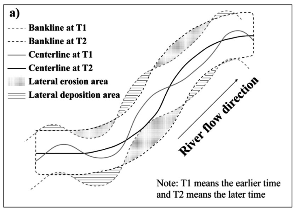
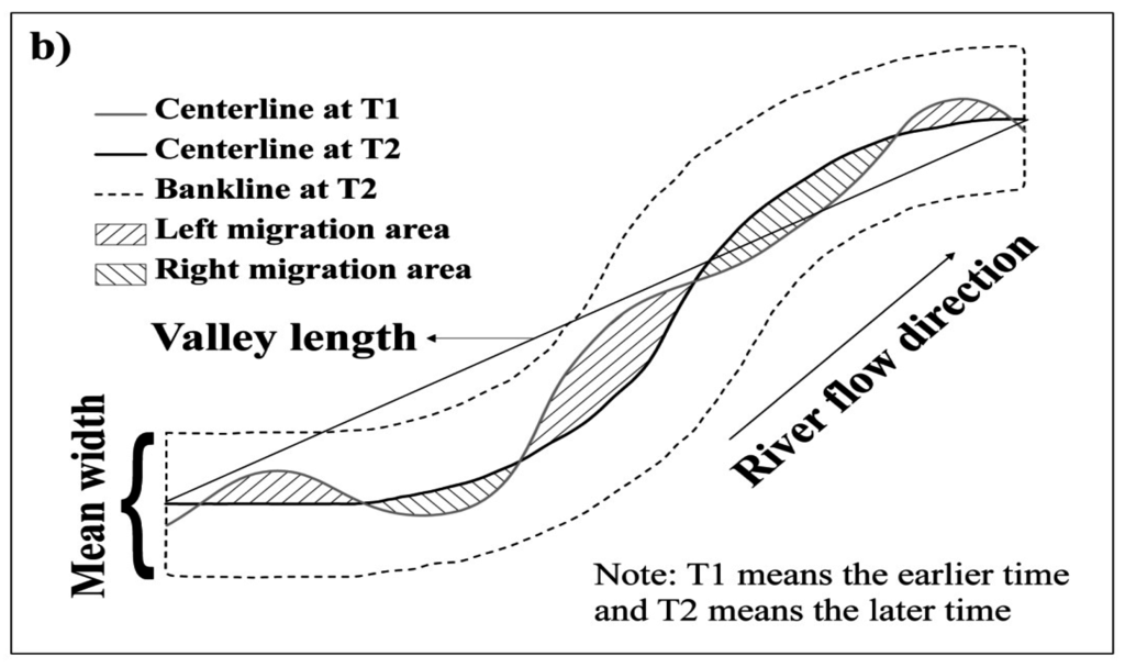
Figure 4.
Schematic diagram of several migration parameters: (a) Lateral erosion and deposition area; (b) Migration area of centerline, direction, and mean width.
The flood defense infrastructure is also an important factor affecting the river lateral migration of a typical controlled channel, such as Jingjiang. Thus, the levees and revetments were interpreted according to the panchromatic band (Band 8, 15 m) of Landsat 8 image which acquired on 29 December 2013. The lengths of the levees and revetments were correspondingly measured according to their location on the left or right bank of the river. Only the lateral shifting of channels could be observed on the basis of the remote sensing methods. The historic scour depth data were compared in different historical periods to understand the vertical scouring magnitude better. The mean scour depth in the LJR channel was computed as the ratio between scoured volumes and total water surface area over the period between 2002 and 2012.
4. Results
4.1. Channel Planform Migration Trajectories
The water surface area of the LJR exhibited no ideal trend in the past 30 years but showed an evident downward shift in general (at the 95% confidence level) (Figure 5). During the period of 1983–2013, the maximum water surface area of the study river reach was 109.46 km2, which occurred in 1988. However, the area declined rapidly after 1988 and finally became 96.04 km2 in 2013, which was the minimum water surface area. The maximum mean width of the river channel was 913.8 m in 1988, approximately 8% wider than for the earlier and later years. In 2002, the mean width of the channel decreased to 829.3 m, which was the minimum mean width during the period of 1983–2013.
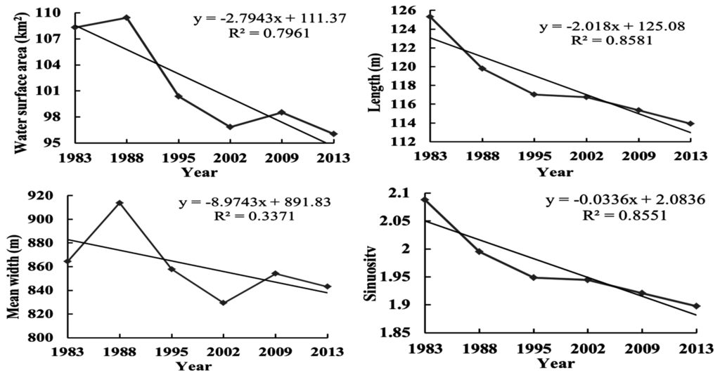
Figure 5.
Change trends of several channel morphometric parameters.
In the past 30 years, the river length of the LJR decreased continuously from 125.32 km in 1983 to 113.31 km in 2013. The total decrease rate from 1983 to 2013 was 9.1%, and the annual average decrease in length was 380 m/a. The decrease rates of five periods (1983–1988, 1988–1995, 1995–2002, 2002–2009, 2009–2013) were 4.42%, 2.3%, 0.22%, 1.22% and 1.24%, respectively. The annual decrease in lengths of five periods were 1,110 m/a, 390 m/a, 40 m/a, 200 m/a and 360 m/a. Similarly, the sinuosity of the river channel was constantly decreasing during the period of 1983–2013. The maximum sinuosity of the river channel was 2.09 in 1983 and decreased to 1.9 in 2013, which was the minimum value in the past 30 years. The sinuosity of the river channel was constantly decreasing. However, the sinuosity of the river channel was still larger than 1.3 in 2013. This channel was still a typical meandering channel, although the river channel pattern has a tendency to be straight.
4.2. Channel Migration Rate
Significant decreasing trends of total migration area and rate were observed over the period of 1983–2013 in the channel (Figure 6). Compared with the earliest period (1983–1988), the total migration area increased slightly in the period of 1988–1995. Then, the migration area decreased sharply from 20.64 km2 in 1988–1995 to 5.36 km2 in 2009–2013. The total migration area has reduced by 74% in the past 30 years. A sustained reduction of migration rate has occurred in the reach. After 1983 and prior to 1988, the migration rate was 31.05 m·year−1, whereas the rate decreased to 11.62 m·year−1 between 2009 and 2013, with a significant decrease of 63%.
According to the migration direction, the total migration area to the left bank was 45.29 km2 in the past 30 years. However, the migration area to the right bank was only 25.6 km2, approximately half of the area to the left bank. The migration area to the left bank exhibited a linear trend of decline from 15.41 km2 to 2.14 km2 during the period of 1983–2013. The migration area to the right bank exhibited a slight increase in the period of 1988–1995 and decreased to 3.22 km2 between 2009 and 2013. Besides this, the migration rate of left bank also exhibited a linear trend of decline from 20.48 km·year−1 to 3.71 km·year−1 and the migration rate of right bank exhibited an irregular trend. In general, an evident tendency of shifting to the left bank occurred in the river channel from 1983 to 2013.
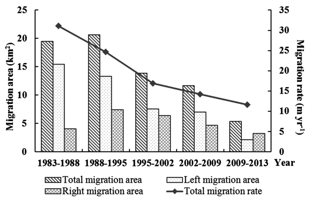
Figure 6.
Channel migration area and rate of LJR in 1983–2013.
4.3. Lateral Erosion and Deposition
During the past 30 years, the area and annual rate of lateral erosion and deposition all showed a decreasing trend, with decrease rates of 77% and 72%, respectively. As shown in Table 2, the area subjected to lateral erosion during the period of 1983–1988 in the LJR was 21.32 km2, whereas the area subjected to lateral deposition was 25.73 km2. However, the lateral erosion and deposition area rates between 2009 and 2013 were only 4.83 and 5.83 km2, respectively. The change trends of the annual lateral erosion and deposition rates were in accordance with the area change. The annual lateral erosion and deposition rates in the period of 1983–1988 were 4.26 and 5.15 km2·year−1, which were the maximum during the five time intervals. Meanwhile, the annual lateral erosion and deposition rates in the period of 2009–2013 decreased to 1.21 and 1.46 km2·year−1. In general, lateral deposition exceeded erosion during the time interval along the study river reach, except for the time period of 2009–2013.
Table 2.
Lateral erosion and deposition areas and rates of the Lower Jingjiang Reach (LJR) from 1983 to 2013.
| Time Interval | Total Lateral Erosion Area (km2) | Annual Lateral Erosion Rate (km2·Year−1) | Total Lateral Deposition Area (km2) | Annual Lateral Deposition Rate (km2·Year−1) |
|---|---|---|---|---|
| 1983–1988 | 21.32 | 4.26 | 25.73 | 5.15 |
| 1988–1995 | 17.43 | 2.49 | 23.05 | 3.29 |
| 1995–2002 | 13.94 | 1.99 | 18.97 | 2.71 |
| 2002–2009 | 10.29 | 1.47 | 13.76 | 1.97 |
| 2009–2013 | 4.83 | 1.21 | 5.83 | 1.46 |
5. Discussion
Spatial variations and temporal dynamics of planform changes were observed in the LJR during the period of 1983–2013. In terms of the spatial variation, the planform morphometric change of the LJR mainly occurred in certain typical reaches. Regarding the temporal dynamics during the past 30 years, frequent human activities, such as the construction of dams and river regime control projects, restricted the migration of the LJR. The river channel was gradually developing to a stable state, but still had a remarkable tendency to migrate to the left bank. As the water and sediment processes in the LJR had significantly changed after the construction of the TGD, the erosion in the riverbed and the river–lake relationship between Dongting Lake and LJR had also changed.
5.1. Spatial Variations of Several Typical Reaches
Although the river regime of the entire channel tended towards a steady state, a few typical reaches, such as Xiangjiazhou, Tiaoguan and Jianli, still underwent a drastic change from 1983 to 2013 (Figure 7 and Figure 8). In Xiangjiazhou bend (A in Figure 8), after nature bend bypassing and shoal cutting that occurred in 1994, the maximum migration distance (1493 m) of the channel centerline was achieved according to the result extracted from the satellite imagery. The results of the field survey [48,49] showed that the top spot of the mainstream shifted downstream to Beimenkou by 2 km after the nature bend bypassing and shoal cutting in Xiangjiazhou. Afterwards, the left bank kept collapsing and the riverbank line kept migrating to the left as far as 3 km in this reach. In 2002–2009, a central bar lying in the bend integrated with the right bank resulted in the maximum migration distance (880 m) of the channel centerline to the left bank. For the Tiaoguan bend (B in Figure 8), the river regime was evidently adjusted after the nature cutoff of Shatanzi in 1972. From 1983 to 1988, a visible migration to the left bank led to the maximum migration distance of 1097 m. However, the migration distance decreased after 1988 and still exhibited a tendency to shift to the left. The migration to the left bank in the past 30 years resulted in the decrease in sinuosity in Tiaoguan bend from 4.37 in 1983 to 3.94 in 2013, which is still approximately two times higher than the entire channel. If this phenomenon continues, then a nature cutoff may occur in this bend, even without the influence of human activities. The channel centerline of Jianli bend (C in Figure 8) kept moving to the northeast (left bank) and maintained at a steady state during the past 30 years. As a result, the right bank of the Wuguizhou central bar kept scouring and the river width of the right branch gradually broadened. By contrast, the left bank of the central bar was depositing and the river width of the left branch became narrowed. The main flow transferred from the left branch to the right branch ultimately.
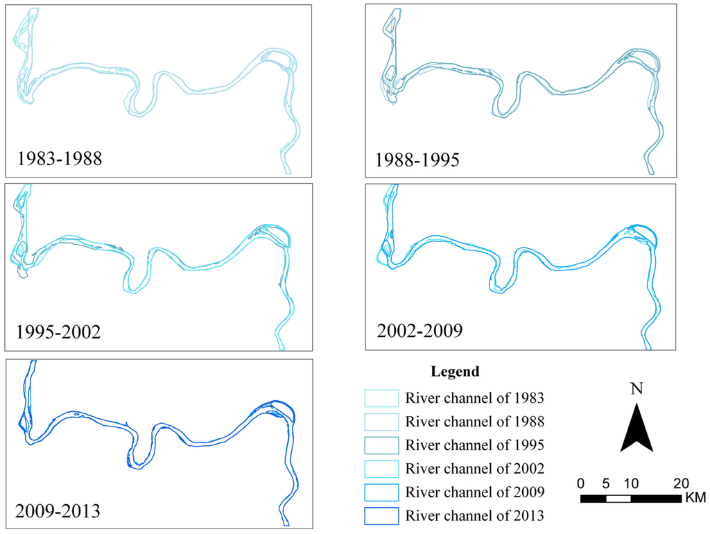
Figure 7.
Migration of the river channel between different periods.
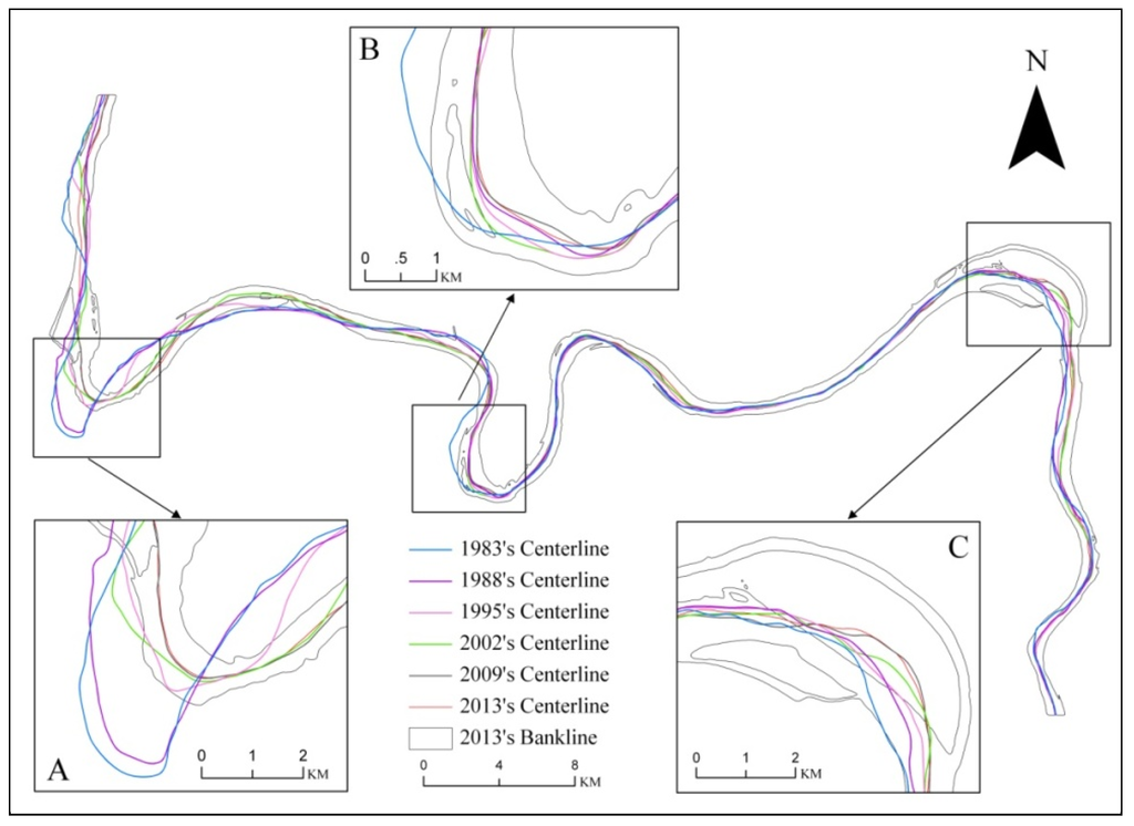
Figure 8.
Migration of the channel centerline in 1983–2013. Note: (A) is Xiangjiazhou bending, (B) is Tiaoguan bending and (C) is Jianli bending.
For several centuries, the LJR developed a meandering channel pattern and maintained a high sinuosity. However, several natural and artificial cutoffs occurred in the LJR during the late 1960s and early 1970s. Thus, sinuosity decreased from 2.83 to 1.93 [28]. To date, the LJR still remains a typical meandering channel and will maintain this pattern for many years, although sinuosity kept decreasing from 1983 to 2013. If the decrease rate of sinuosity continues in the next 100 years, then this river section will become a straight river channel. In other words, sinuosity will be equal to or lower than 1.3. Similarly, according to the research of Hu et al. (2011) [50], the LJR will develop into a limited meandering channel in a short time with the implementation of several river regulation and bank revetment projects.
5.2. Levee and Bank Revetment Construction
Channel morphometric and dynamic changes were strongly affected by the bank protection structures along a meandering river [51,52]. Several bank protection and flood control projects in the LJR have significantly decreased the channel morphometric parameters, such as channel length, sinuosity, migration area and rate and lateral erosion and deposition. This phenomenon indicated that the river regime of the LJR was gradually developing to a stable state. The levee and bank revetment of the LJR were extracted based on the remotely sensed image in 2013 to determine the influence of these projects (Figure 9). The results showed that the length of the major and minor levees in the study area was 215.15 and 316.86 km, respectively. The total length of the bank revetment along the river channel was 107.45 km, of which the length of the left bank was 58.34 km and that of the right bank was 49.11 km. The intense levee and bank revetment construction almost completely controlled the channel. As shown in Figure 8, the construction of bank revetments has significantly restricted the migration of the bank line.
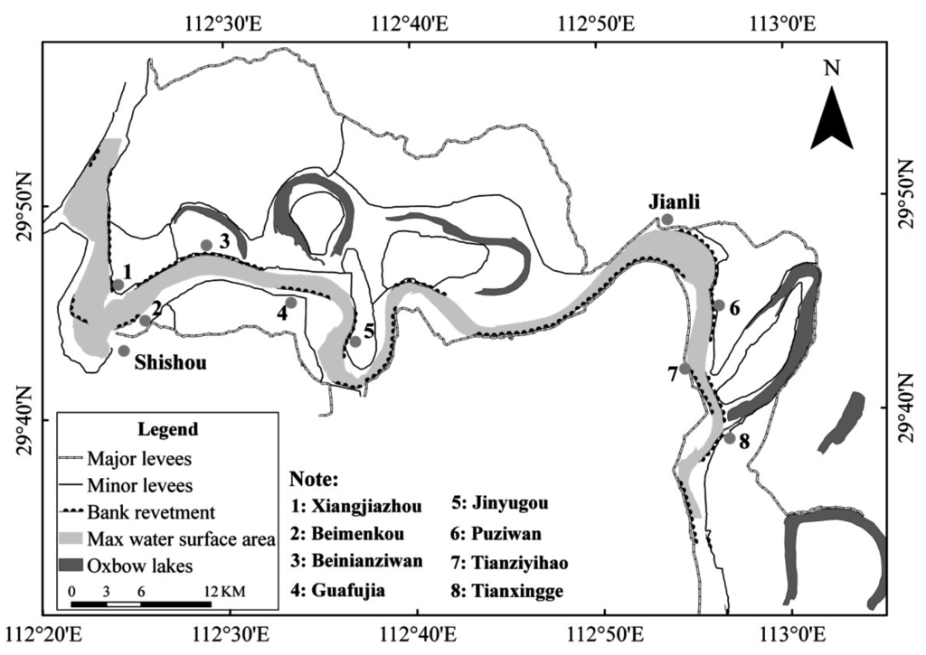
Figure 9.
Levee and bank revetment projects in the LJR.
The bank revetments mainly distributed in susceptible meanders, such as Xiangjiazhou, Tiaoguan and Jianli bends. From 1983 to 2002, the majority of the riverbanks in these bends have collapsed massively because of the violent lateral scouring. However, with the sustained construction of bank revetments after 2002, the bank line was ultimately maintained within the scope of the bank revetment (Figure 10). A drastic decrease in the migration distance was observed before and after the construction of bank revetments (Table 3). All these findings indicated that the bank revetments along the LJR had an evident protective effect against riverbank erosion and had ensured the stability of the bank line.
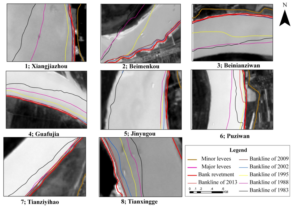
Figure 10.
Restrictive effect of bank revetments on the bank lines. Sub-figures 1–8 means the bank revements in Xiangjiazhou, Beimenkou, Beinianziwan, Guafujia, Jinyugou, Puziwan, Tianziyihao and Tianxingge, respectively.
Table 3.
Bank line migration before and after the construction of revetments.
| No. | Bank Revetment | Length (m) | Build Year | Before (m) | After (m) |
|---|---|---|---|---|---|
| 1 | Xiangjiazhou | 1228 | 1994–2001 | 990 | 12 |
| 2 | Beimenkou | 2894 | 1994–2002 | 968 | 20 |
| 3 | Beinianziwan | 12,647 | 1971–2001 | 897 | 16 |
| 4 | Guafujia | 4857 | 2001–2002 | 565 | 14 |
| 5 | Jinyugou | 4519 | 1977–1994 | 591 | 15 |
| 6 | Puziwan | 11,779 | 1977–2002 | 272 | 26 |
| 7 | Tianziyihao | 4571 | 1969–2002 | 358 | 23 |
| 8 | Tianxingge | 3625 | 1982–1986 | 155 | 39 |
Note: Before/After: migration distance before or after the construction of the revetment.
By contrast, although an evident restrictive effect of bank revetments on the bank lines was observed and the length of bank revetment in the left bank was similar to that of bank revetment in the right bank, the river channel still had a remarkable tendency to migrate to the left bank. This trend may be caused by the geomorphological difference between the left and right banks. The left bank is a fluvial plain area with worse anti-erosion ability, and the right bank has many hilly terraces to protect the bank. Accordingly, the remnant phenomena, such as bank failures, of the river regime changed, and oxbow lakes also existed mainly on the left bank.
The migration of the river channel also had an effect on the revetment; for example, the change of the mainstream, rushing point and scour hole could destroy the revetments along the river channel [53]. Therefore, more attention should be focused on the left bank, and the bank revetments of left bank should be kept reinforced and adjusted with the change of water and sediment conditions.
5.3. Water and Sediment Changes after the Construction of the TGD
Water and sediment processes in a fluvial environment have a significant influence on the planform morphometric parameters of a river channel [54,55]. According to the results of the Changjiang Water Resources Commission and many other studies [56,57,58], water and sediment processes were drastically changed in the LJR after the cutoff of Gezhouba Dam in 1981 and the impoundment of the Three Gorges Reservoir in 2003. A severe decrease in sediment load notably occurred in the LJR. In general, the reduction of sediment would aggravate the lateral erosion and would increase the river width under a similar runoff condition. However, lateral erosion in the LJR exhibited a contrary result under the remote sensing approach. This result can be attributed to the restrictive effect of bank revetment on the lateral erosion in the channel. As the lateral erosion has been restricted, the undercutting or longitudinal erosion in the riverbed will be enhanced. In fact, according to the results of different studies [25,59,60] using the field survey method, the mean scour depth in the LJR in 2002–2012 ranged from 1.4 m to 2.36 m. However, the mean scour depth was only approximately 0.07 m between 1998 and 2002 (before the construction of the TGD) in the LJR based on the calculation of Yan (2013) [61]. We also computed the mean scour depth in the period of 2002–2012 for the bankfull channel in the LJR. The results showed that the mean scour depth of the LJR between 2002 and 2012 was 2.04 m, which was close to the result of Hu et al. (2014) [62].
Dongting Lake is the second largest freshwater lake in China, and the main outlet of the lake is on the LJR. If the scouring and undercutting continues, then the water level of the LJR will decrease and the sediment volume into Dongting Lake will consequently decrease. The results of Sun et al. (2012) [63] show that, during the water storage periods of the TGD, the water level at the outlet of Dongting Lake decreased by 2.03 m in 2006 and by 2.11 m in 2009, with extreme decreases of up to 3.30 and 3.02 m, respectively. Finally, the relationship between rivers and lakes will also change with the long-term and intensive scouring in the LJR.
6. Conclusions
The main conclusions derived from this study are as follows: (i) The planform morphometric parameters, including water surface area, river length, mean width and sinuosity, of the LJR during the period of 1983–2013 exhibited a generally decreasing trend. The total decrease rates were 11.3%, 9.1%, 2.5% and 9.1%; (ii) The total migration area to the left bank was approximately two times that of the right bank. The centerline in the LJR exhibited a visible tendency to migrate to the left bank in the past 30 years; (iii) With the construction of bank revetments and the implementation of river regime control projects in the LJR, the migration rate decreased from 31.05 m·year−1 in 1983–1988 to 11.62 m·year−1 in 2009–2013. The lateral erosion and deposition areas of the LJR decreased from 21.32 and 25.73 km2 in 1983–1988 to 4.83 and 5.83 km2 in 2009–2013; (iv) The mean scour depth in the riverbed of the LJR after the construction of the TGD (2002–2012) was approximately 30 times that of the previous period (1998–2002). In general, the bank revetments restricted the lateral migration of the river channel in the LJR during the past 30 years, and the undercutting in the riverbed was strengthened after the construction of the TGD. As a result, the LJR has gradually become a typical controlled channel.
The construction of some huge dams such as Three Georges and Gezhouba on the Yangtze River have terribly changed the hydrological regime downwards of the dam. As a section in the middle reaches of the Yangtze River, LJR has gone through channel migrations for centuries. This paper quantified the planform morphological changes of LJR by remote sensing during the period of 1983–2013. The trajectory analysis based on the remote sensing method could be applied in other similar river reaches with high intensive human activities. In addition, the study also gives out some guidance for river course regulation, navigation safety and revetment construction of the reach.
Acknowledgments
This work was funded by the (1) National Nature Science Foundation of China (Grant No. 41571202, 41171426, 41101427, 41331174); (2) The Key Program of Institute of Geodesy and Geophysics, Chinese Academy of Sciences; (3) National Natural Science Foundation of Hubei, China (Grant No. 2011CDA075); (4) Surveying & Mapping and Geoinformation Research in the Public Interest (201512026).
Author Contributions
Chao Yang, Xiaobin Cai and Xuelei Wang conceived and designed the study. Chao Yang, Xiaobin Cai and Ranran Yan made substantial contributions to acquisition, analysis and interpretation of the data. The manuscript was written by Chao Yang with contributions from all authors. Ting Zhang, Qing Zhang and Xiaorong Lu provided valuable suggestions for the revision and were involved in the language polishing. All authors read and approved the submitted manuscript, agreed to be listed and accepted the version for publication.
Conflicts of Interest
The authors declare no conflict of interest.
References
- Petts, G.E. Changing river channels: The geographical tradition. In Changing River Channel; Wiley: Chichester, UK, 1995; pp. 1–23. [Google Scholar]
- Lawler, D.W. The measurement of river bank erosion and lateral channel change: A review. Earth Surf. Process. Landf. 1993, 18, 777–821. [Google Scholar] [CrossRef]
- Grabowski, R.C.; Surian, N.; Gurnell, A.M. Characterizing geomorphological change to support sustainable river restoration and management. Wiley Interdiscip. Rev. Water 2014, 1, 483–512. [Google Scholar] [CrossRef]
- Yang, X.; Damen, M.C.J.; van Zuidam, R.A. Satellite remote sensing and GIS for the analysis of channel migration changes in the active Yellow River delta, China. Int. J. Appl. Earth Obs. Geoinf. 1999, 1, 146–157. [Google Scholar] [CrossRef]
- Gurnell, A.M. Channel change on the river Dee meanders, 1946–1992, from the analysis of air photographs. Regul. Rivers Res. Manag. 1997, 13, 13–26. [Google Scholar] [CrossRef]
- Bhuiyan, M.A.; Kumamoto, T.; Suzuki, S. Application of remote sensing and GIS for evaluation of the recent morphological characteristics of the lower Brahmaputra-jamuna river, Bangladesh. Earth Sci. Inf. 2014, 8, 1–18. [Google Scholar] [CrossRef]
- Joeckel, R.M.; Henebry, G.M. Channel and island change in the lower Platte River, eastern Nebraska, USA: 1855–2005. Geomorphology 2008, 102, 407–418. [Google Scholar] [CrossRef]
- Thakur, P. River bank erosion hazard study of river Ganga, upstream of Farakka barrage using remote sensing and GIS. Nat. Hazards 2012, 61, 967–987. [Google Scholar] [CrossRef]
- Petropoulos, G.P.; Kalivas, D.P.; Griffiths, H.M.; Dimou, P.P. Remote sensing and GIS analysis for mapping spatio-temporal changes of erosion and deposition of two mediterranean river deltas: The case of the Axios and Aliakmonas Rivers, Greece. Int. J. Appl. Earth Obs. Geoinf. 2015, 35, 217–228. [Google Scholar] [CrossRef]
- Sarkar, A. RS-GIS based assessment of river dynamics of Brahmaputra River in India. J. Water Resour. Protect. 2012, 4, 63–72. [Google Scholar] [CrossRef]
- Rozo, M.G.; Nogueira, A.C.R.; Castro, C.S. Remote sensing-based analysis of the planform changes in the upper Amazon River over the period 1986–2006. J. S. Am. Earth Sci. 2014, 51, 28–44. [Google Scholar] [CrossRef]
- Goswami, U.; Sarma, J.; Patgiri, A. River channel changes of the Subansiri in Assam, India. Geomorphology 1999, 30, 227–244. [Google Scholar] [CrossRef]
- Chakraborty, S.; Mukhopadhyay, S. An assessment on the nature of channel migration of River Diana of the sub-himalayan west Bengal using field and GIS techniques. Arabian J. Geosci. 2014, 8, 1–13. [Google Scholar] [CrossRef]
- Evans, J.E.; Huxley, J.M.; Vincent, R.K. Upstream channel changes following dam construction and removal using a GIS/remote sensing approach. J. Am. Water Resour. Assoc. 2007, 43, 683–697. [Google Scholar] [CrossRef]
- Kiss, T.; Blanka, V. River channel response to climate- and human-induced hydrological changes: Case study on the meandering Hernád River, Hungary. Geomorphology 2012, 175–176, 115–125. [Google Scholar] [CrossRef]
- Rozo, M.G.; Nogueira, A.C.; Truckenbrodt, W. The anastomosing pattern and the extensively distributed scroll bars in the middle Amazon River. Earth Surf. Process. Landf. 2012, 37, 1471–1488. [Google Scholar] [CrossRef]
- Mertes, L.A.; Dunne, T.; Martinelli, L.A. Channel-floodplain geomorphology along the solimões-Amazon River, Brazil. Geol. Soc. Am. Bull. 1996, 108, 1089–1107. [Google Scholar] [CrossRef]
- Pan, Q. Study on evolution of middle and lower reaches of Yangtze River in recent fifty years. J. Yangtze River Sci. Res. Inst. 2001, 18, 18–22. (in Chinese). [Google Scholar]
- Shao, X.; Wang, H.; Wang, Z. Fluvial processes in the lower Jingjiang River: Impact of the three gorges reservoir impoundment. Int. J. Sediment Res. 2005, 20, 102. [Google Scholar]
- Li, Y.; Gu, R.R. Modeling flow and sediment transport in a river system using an artificial neural network. Environ. Manag. 2003, 31, 0122–0134. [Google Scholar]
- Wang, Z.; Chen, Z.; Li, M.; Chen, J.; Zhao, Y. Variations in downstream grain-sizes to interpret sediment transport in the middle-lower Yangtze River, China: A pre-study of Three-Gorges dam. Geomorphology 2009, 113, 217–229. [Google Scholar] [CrossRef]
- Chen, Z.; Wang, Z.; Finlayson, B.; Chen, J.; Yin, D. Implications of flow control by the Three Gorges dam on sediment and channel dynamics of the middle Yangtze (Changjiang) River, China. Geology 2010, 38, 1043–1046. [Google Scholar] [CrossRef]
- Jiang, L.; Ban, X.; Wang, X.; Cai, X. Assessment of hydrologic alterations caused by the Three Gorges dam in the middle and lower reaches of Yangtze River, China. Water 2014, 6, 1419–1434. [Google Scholar] [CrossRef]
- Xia, J.; Zong, Q.; Deng, S.; Xu, Q.; Lu, J. Seasonal variations in composite riverbank stability in the lower Jingjiang reach, China. J. Hydrol. 2014, 519, 3664–3673. [Google Scholar] [CrossRef]
- Xia, J.; Zong, Q.; Zhang, Y.; Xu, Q.; Li, X. Prediction of recent bank retreat processes at typical sections in the Jingjiang reach. Sci. China Technol. Sci. 2014, 57, 1490–1499. [Google Scholar] [CrossRef]
- Yu, W. Preliminary study on forming condition of lower Jingjiang meandering channels of middle Yangtze River. J. Yangtze River Sci. Res. Inst. 2006, 6, 9–13. (in Chinese). [Google Scholar]
- Li, J.; Chang, J.; Lu, D.; Zhu, X.; Lu, C.; Zhou, Y.; Deng, C. The hydrological effect between Jingjiang River and Dongting lake during initial period of Three Gorges project operation. Acta Geogr. Sin. 2009, 11, 1342–1352. (in Chinese). [Google Scholar]
- Yin, H.; Liu, G.; Pi, J.; Chen, G.; Li, C. On the river–lake relationship of the middle Yangtze reaches. Geomorphology 2007, 85, 197–207. [Google Scholar] [CrossRef]
- Yuan, W.; Yin, D.; Finlayson, B.; Chen, Z. Assessing the potential for change in the middle Yangtze River channel following impoundment of the Three Gorges dam. Geomorphology 2012, 147, 27–34. [Google Scholar] [CrossRef]
- Changjiang Water Resources Commission. Changjiang Sediment Bulletin; Changjiang Press: Wuhan, China, 2013. (in Chinese) [Google Scholar]
- Xia, J.; Zong, Q.; Deng, S.; Xu, Q.; Zhang, Y. Adjustment in reach-scale bankfull channel geometry of Jingjiang reach after operation of Three Gorges project. J. Zhejiang Univ. (Eng. Sci.) 2015, 49, 238–245. (in Chinese). [Google Scholar]
- Xu, Q. Study of sediment deposition and erosion patterns in the middle and downstream Changjiang mainstream after impoundment of TGR. J. Hydroelectr. Eng. 2013, 2, 146–154. (in Chinese). [Google Scholar]
- Yang, H.; Tang, R. Study on the Evolution of Jingjiang Reach of Middle Yangtze River; Chinese Water Power Press: Beijing, China, 1998. (in Chinese) [Google Scholar]
- Chen, Z.; Yu, L.; Gupta, A. The Yangtze River: An introduction. Geomorphology 2001, 41, 73–75. [Google Scholar] [CrossRef]
- Yin, H.; Li, C. Human impact on floods and flood disasters on the Yangtze River. Geomorphology 2001, 41, 105–109. [Google Scholar] [CrossRef]
- Zhang, X. The migration of yunmeng marsh and the forming of lower Jingjiang meandering channels in middle Yangtze River. Fudan J. (Soc. Sci. Ed.) 1980, 2, 35–46. (in Chinese). [Google Scholar]
- Wang, S.; Chen, Z.; Smith, D.G. Anastomosing river system along the subsiding middle Yangtze River basin, southern China. CATENA 2005, 60, 147–163. [Google Scholar] [CrossRef]
- You, L. A study of the formation and evolution of braided channels with stable islands: The middle and lower reaches of the Yangtze River. Int. Geomorphol. 1986, 1, 649–662. [Google Scholar]
- Ou, C.; Peng, P.; Deng, C.; Li, J. In impacts of three gorges reservoir’s water storage on flow-sediment characteristics of Dongting Lake. In Proceedings of the 2011 International Conference on Electric Technology and Civil Engineering (ICETCE), Lushan, China, 22–24 April 2011; pp. 6012–6015.
- Hui, F.M.; Xu, B.; Huang, H.B.; Yu, Q.; Gong, P. Modelling spatial-temporal change of Poyang Lake using multitemporal Landsat imagery. Int. J. Remote Sens. 2008, 29, 5767–5784. [Google Scholar] [CrossRef]
- Jain, S.K.; Singh, R.; Jain, M.; Lohani, A. Delineation of flood-prone areas using remote sensing techniques. Water Resour. Manag. 2005, 19, 333–347. [Google Scholar] [CrossRef]
- McFeeters, S. The use of the normalized difference water index (NDWI) in the delineation of open water features. Int. J. Remote Sens. 1996, 17, 1425–1432. [Google Scholar] [CrossRef]
- Guo, B.; Wang, T.; Zhao, R. In research on extracting skeleton line of polygon. In Proceedings of the 2010 2nd IEEE International Conference on Information Management and Engineering (ICIME), Chengdu, China, 16–18 April 2010; pp. 514–517.
- Schumm, S. Sinuosity of alluvial rivers on the Great Plains. Geol. Soc. Am. Bull. 1963, 74, 1089–1100. [Google Scholar] [CrossRef]
- Moody-Stuart, M. High-and low-sinuosity stream deposits, with examples from the devonian of Spitsbergen. J. Sediment. Res. 1966, 36, 1102–1117. [Google Scholar] [CrossRef]
- Shields, F.D., Jr.; Simon, A.; Steffen, L.J. Reservoir effects on downstream river channel migration. Environ. Conserv. 2000, 27, 54–66. [Google Scholar] [CrossRef]
- Giardino, J.R.; Lee, A.A. Rates of Channel Migration on the Brazos River; Department of Geology & Geophysics, Texas A&M University: College Station, TX, USA, 2011. [Google Scholar]
- Xu, Q.; Tan, G.; Zhang, X. Research and application of prediction model for river bank failure. Eng. J. Wuhan Univ. 2004, 21, 9–12. (in Chinese). [Google Scholar]
- Shi, J.; Li, N.; Yuan, H.; Long, H. Nearshore riverbed evolution of key dangerous reach of lower Jingjiang river after impoundment of Three Gorges reservoir. Yangtze River 2013, 1, 18–21. (in Chinese). [Google Scholar]
- Hu, X.; Pan, Q. The River Course Regulation Research of Middle and Lower Reaches of the Yangtze River; Chinese Water Power Press: Beijing, China, 2011; p. 496. (in Chinese) [Google Scholar]
- Xu, J. Evolution of mid-channel bars in a braided river and complex response to reservoir construction: An example from the middle Hanjiang River, China. Earth Surf. Process. Landf. 1997, 22, 953–965. [Google Scholar]
- Li, L.; Lu, X.; Chen, Z. River channel change during the last 50 years in the middle Yangtze River, the Jianli reach. Geomorphology 2007, 85, 185–196. [Google Scholar] [CrossRef]
- Xu, F.; Zhang, Y.; Yue, H. Effect of fluvial process to stability of preexisting revetment work in Shishou reach. J. Chongqing Jiaotong Univ. (Nat. Sci.) 2012, 6, 1236–1239. (in Chinese). [Google Scholar]
- Merritt, D.M.; Wohl, E.E. Downstream hydraulic geometry and channel adjustment during a flood along an ephemeral, arid-region drainage. Geomorphology 2003, 52, 165–180. [Google Scholar] [CrossRef]
- Leopold, L.B.; Wolman, M.G. River Channel Patterns: Braided, Meandering, and Straight; US Government Printing Office: Washington, DC, USA, 1957.
- Yang, Z.S.; Wang, H.J.; Saito, Y.; Milliman, J.; Xu, K.; Qiao, S.; Shi, G. Dam impacts on the Changjiang (Yangtze) River sediment discharge to the sea: The past 55 years and after the Three Gorges dam. Water Resour. Res. 2006, 42. [Google Scholar] [CrossRef]
- Xu, K.; Milliman, J.D. Seasonal variations of sediment discharge from the Yangtze River before and after impoundment of the Three Gorges dam. Geomorphology 2009, 104, 276–283. [Google Scholar] [CrossRef]
- Changjiang Water Resources Commission. Changjiang Sediment Bulletin; Changjiang Press: Wuhan, China, 2012. (in Chinese) [Google Scholar]
- Xu, Q. Research on reservoir sedimentation and downstream channel erosion of dam after impoundment of Three Gorges reservoir. Yangtze River 2012, 7, 1–6. (in Chinese). [Google Scholar]
- Pan, Q.; Hu, X. Review of 60 years’ river channel harnessing of Jingjiang reach in Yangtze River. Yangtze River 2015, 46, 1–6. (in Chinese). [Google Scholar]
- Yan, R. Change Analysis of Lower Jingjiang River Evolution with the Aid of Remotely Sensed Data. Master’s Thesis, The University of Chinese Academy of Sciences, Beijing, China, 2013. [Google Scholar]
- Han, J.; Sun, Z.; Huang, Y.; Li, Y. Features and causes of sediment deposition and erosion in Jingjiang reach after impoundment of the Three Gorges project. J. Hydraul. Eng. 2014, 45, 277–295. [Google Scholar]
- Sun, Z.; Huang, Q.; Opp, C.; Hennig, T.; Marold, U. Impacts and implications of major changes caused by the Three Gorges dam in the middle reaches of the Yangtze River, China. Water Resour. Manag. 2012, 26, 3367–3378. [Google Scholar] [CrossRef]
© 2015 by the authors; licensee MDPI, Basel, Switzerland. This article is an open access article distributed under the terms and conditions of the Creative Commons by Attribution (CC-BY) license (http://creativecommons.org/licenses/by/4.0/).