
Mapping High-Resolution Soil Moisture over Heterogeneous Cropland Using Multi-Resource Remote Sensing and Ground Observations


 ,
,
Abstract
:
1. Introduction
2. Data
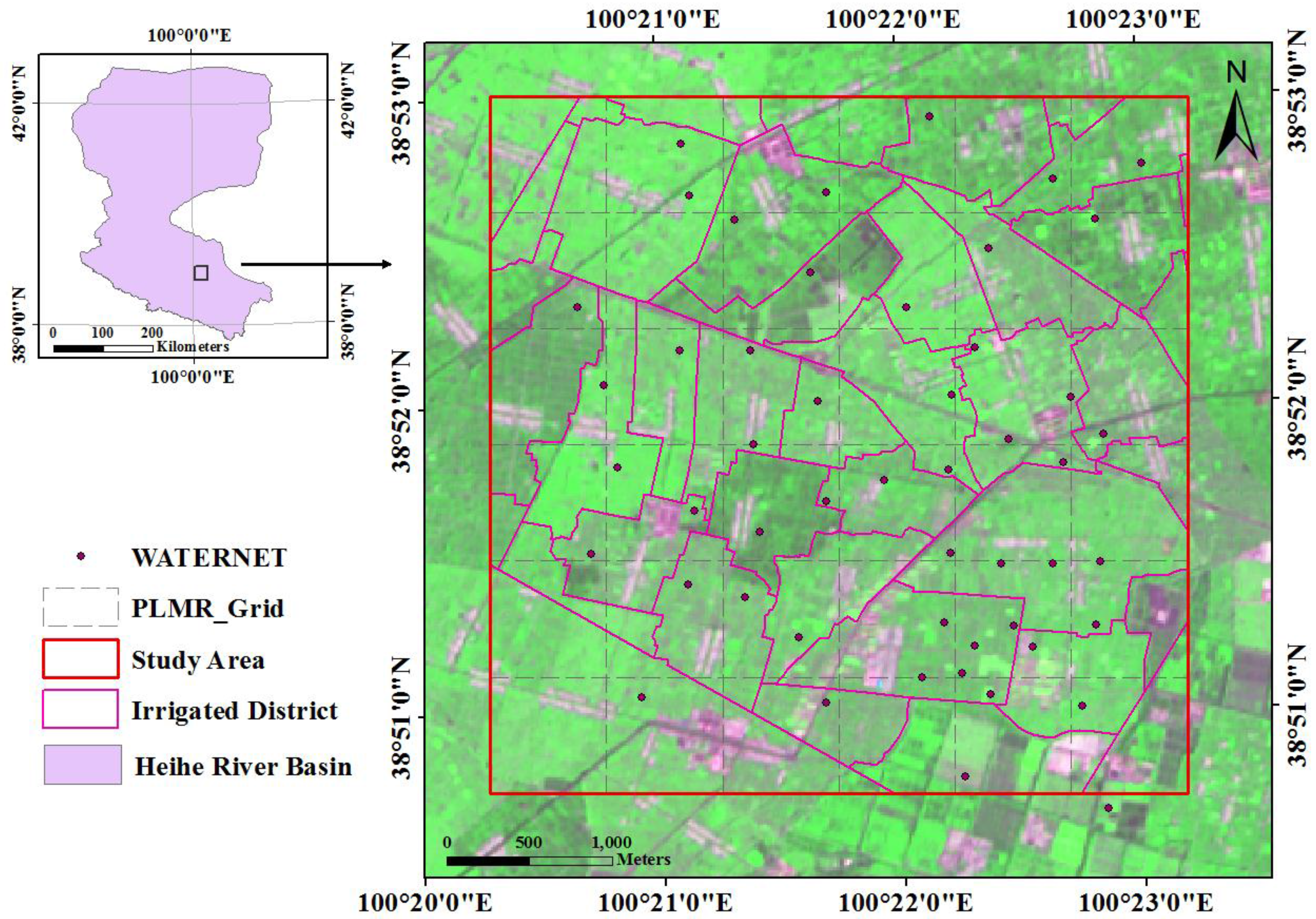
2.1. Soil Moisture Wireless Sensor Network and Irrigation Statistics


| Date | Node Name | Max(%) | Min(%) | Mean(%) | SD(%) |
|---|---|---|---|---|---|
| 30 May | WATERNET | 36.9 | 10.6 | 19 | 6.47 |
| 24 June | WATERNET | 35.3 | 11.7 | 19.7 | 6.86 |
| 10 July | WATERNET | 33.1 | 20.4 | 25.6 | 3.31 |
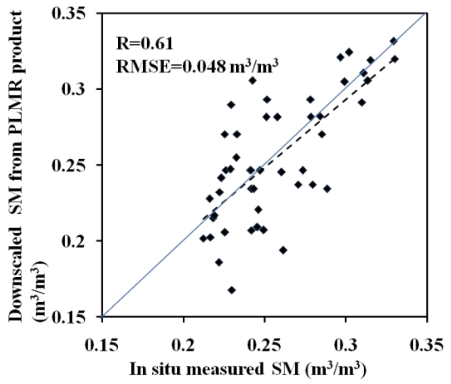
2.2. PLMR-Derived Soil Moisture Products
2.3. ASTER Data
3. Methodology
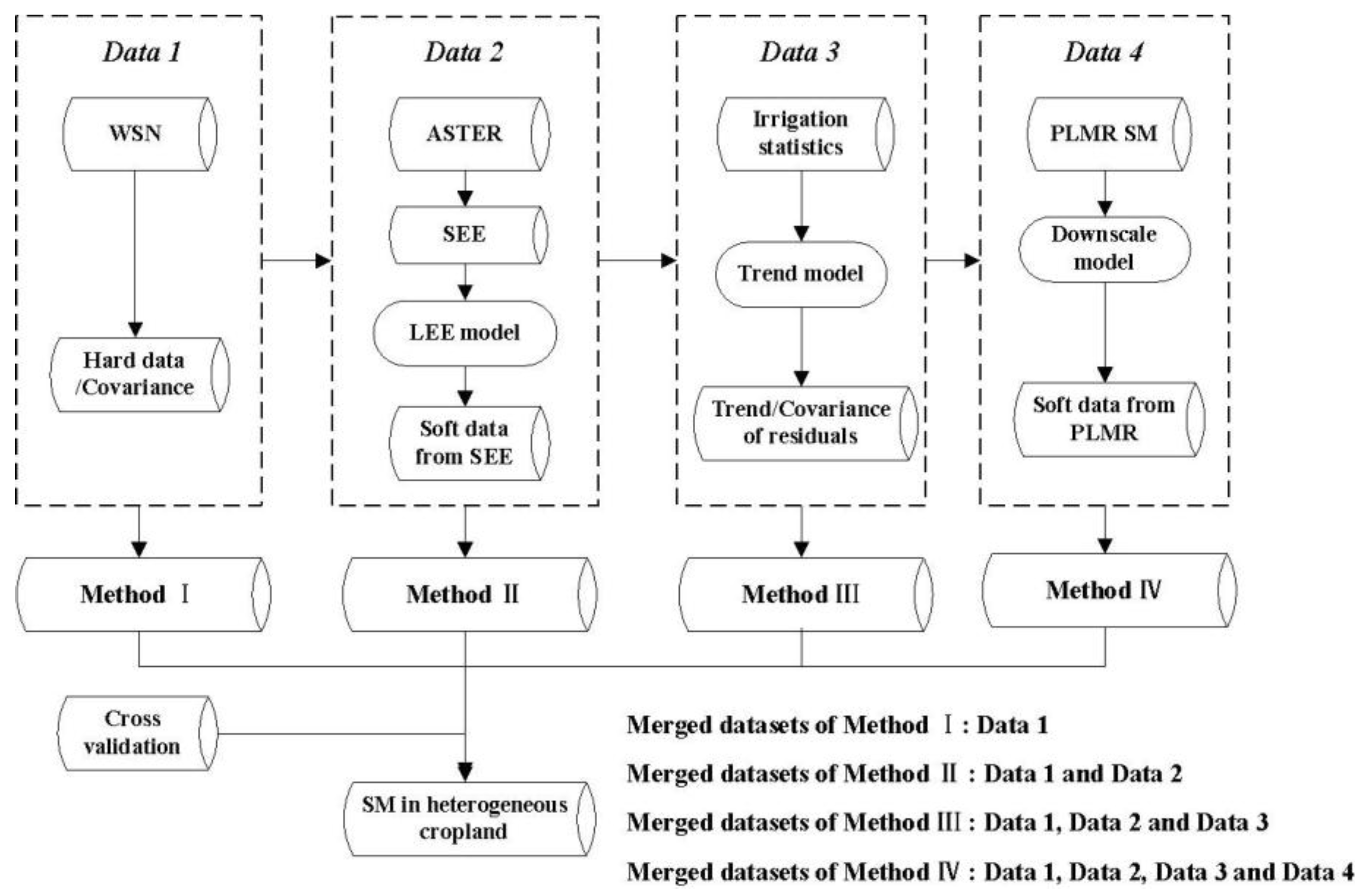
3.1. Predictions Obtained by WSN (Method I)
3.2. Predictions Obtained by Merging WSN and SEE (Method II)
3.2.1. SEE Calculation
3.2.2. Soft Data Estimated from the SEE

3.2.3. BME Estimation
3.3. Predictions Obtained by Merging WSN, SEE and Irrigation Statistics (Method III)
| ASTER Date | PLMR Data | Min_Fr | Max_Fr | Mean_Fr | Periods of Irrigation Influence | (%) | (%) |
|---|---|---|---|---|---|---|---|
| 30 May | None | 0.01 | 0.5 | 0.09 | 25 May–29 May | 31.7 | 16.8 |
| 24 June | None | 0.01 | 0.49 | 0.32 | 19 June–23 June | 34.3 | 17.7 |
| 10 July | Available | 0.01 | 0.59 | 0.45 | 5 July–9 July | 31.1 | 25.5 |
3.4. Predictions Obtained by Merging the WSN, SEE, Irrigation Statistics, and PLMR SM Data (Method IV)

4. Results
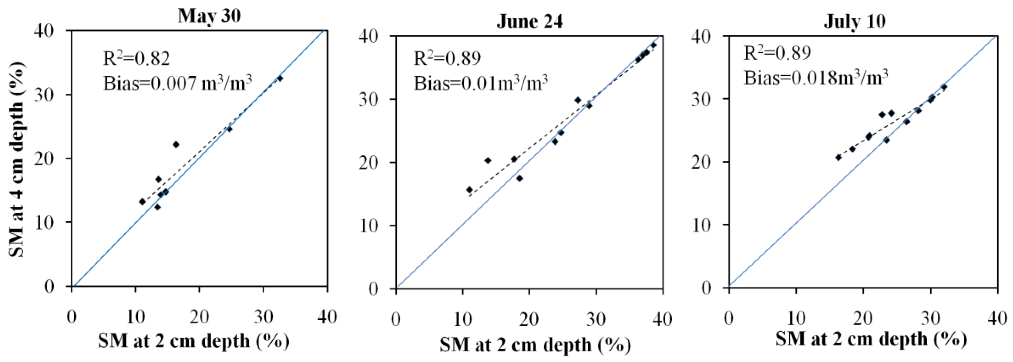
4.1. SM Variograms and Residuals
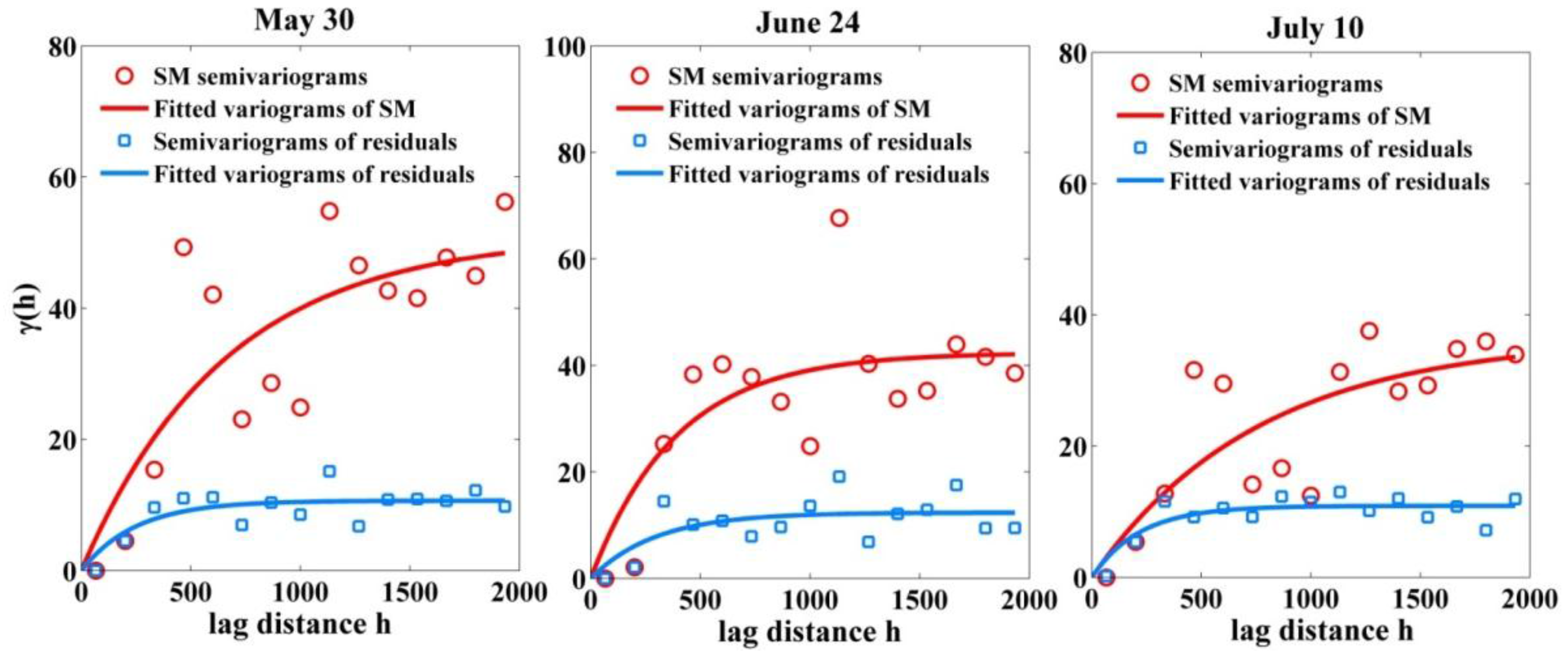
| Date | Variable | Nugget | Sill | Range(m) |
|---|---|---|---|---|
| 30 May | WSN SM | 0.02 | 51.1 | 656.1 |
| 30 May | Residual | 0.01 | 10.7 | 249.1 |
| 24 June | WSN SM | 0.02 | 42.4 | 390.3 |
| 24 June | Residual | 0.02 | 12.4 | 295.6 |
| 10 July | WSN SM | 0.01 | 37 | 808.3 |
| 10 July | Residual | 0.01 | 10.9 | 218.6 |
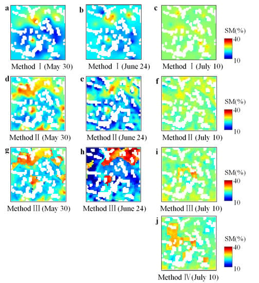
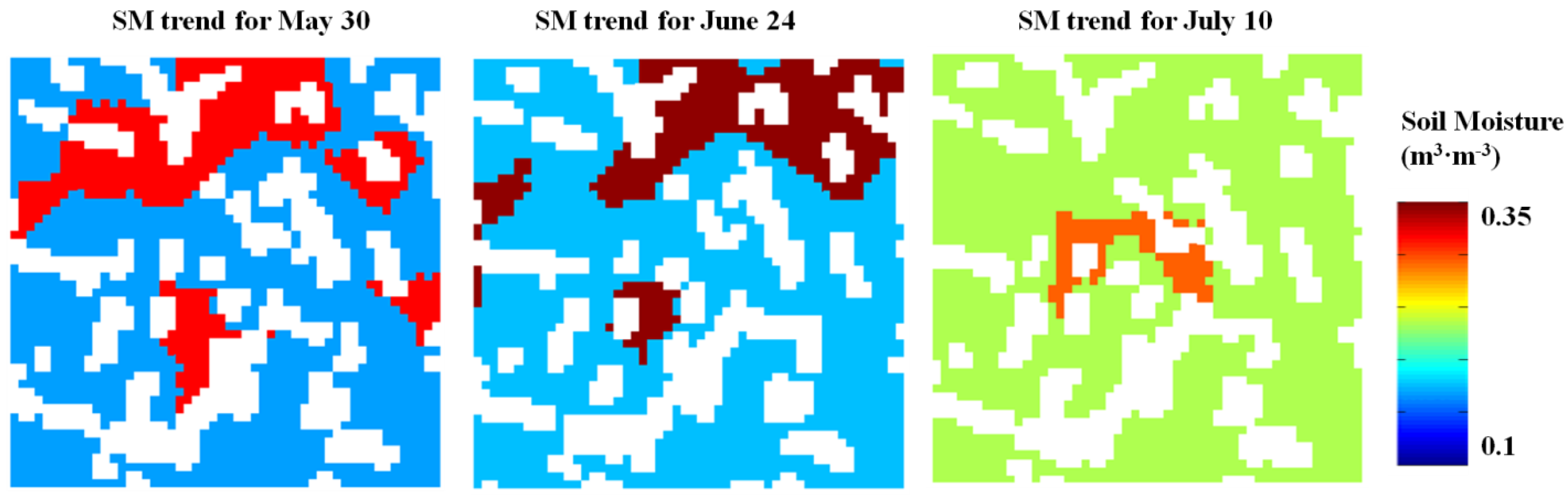
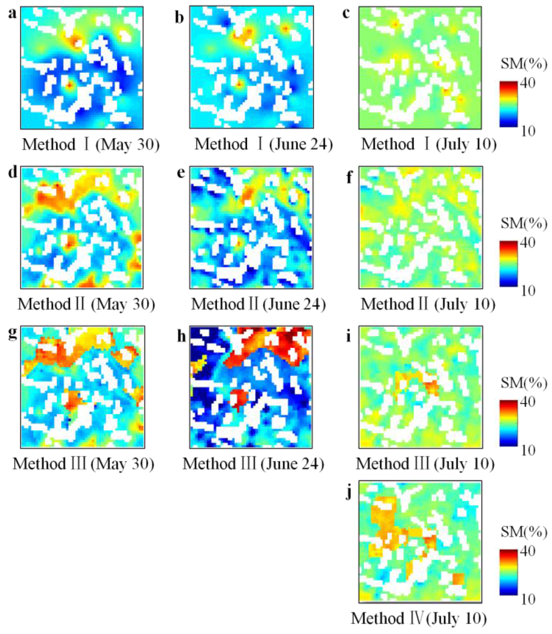
4.2. Spatial Estimation of Soil Moisture
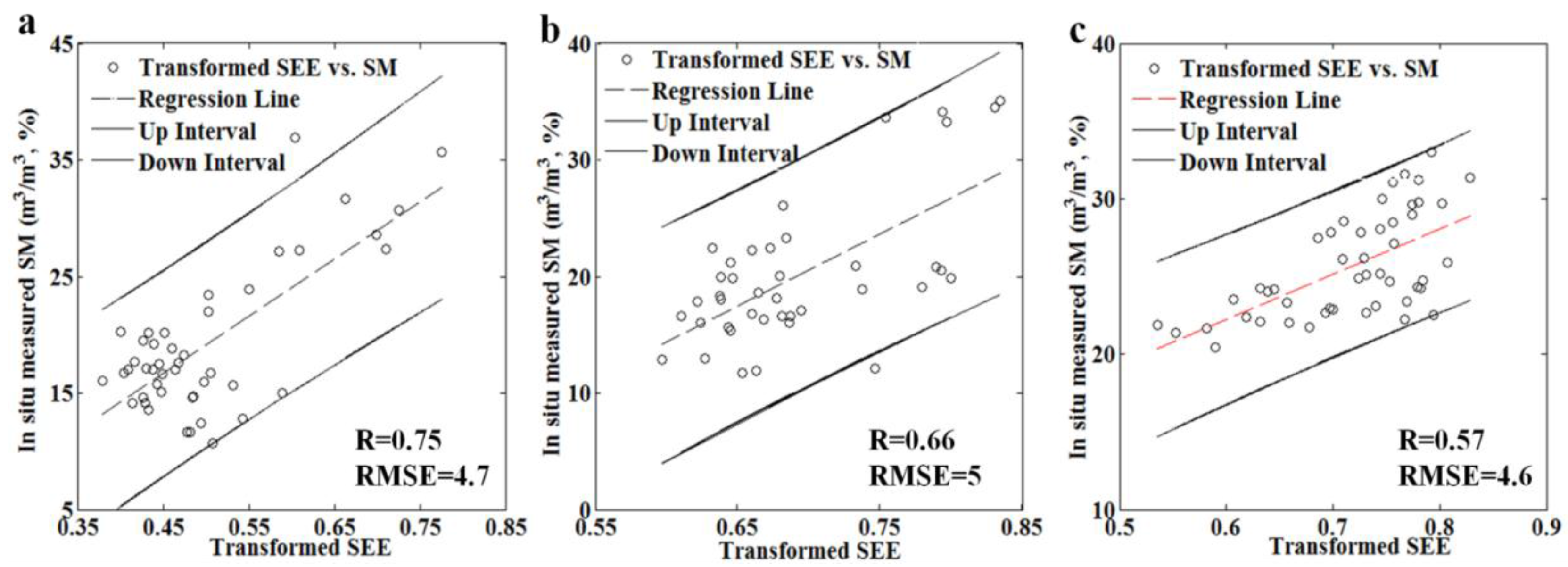
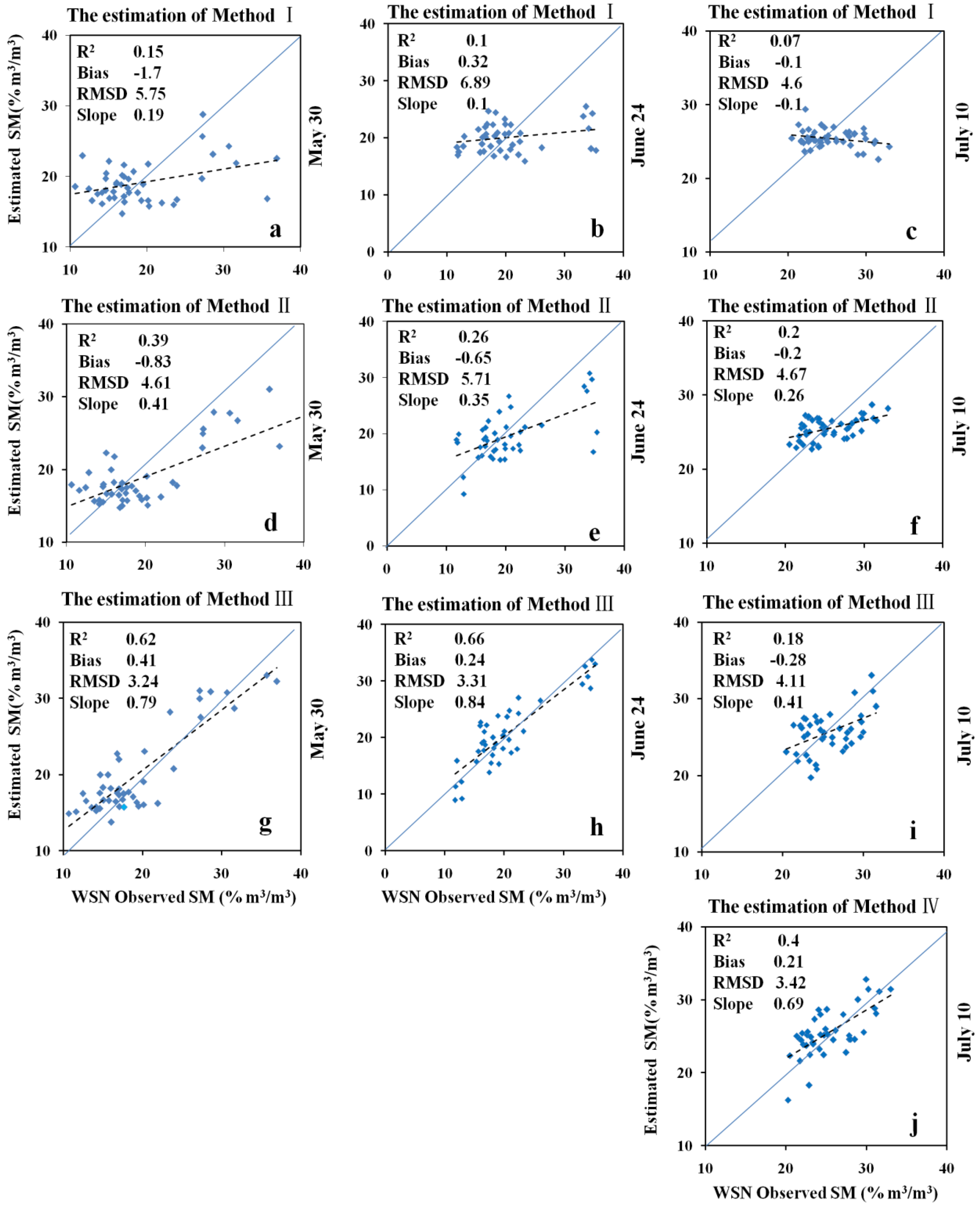
4.3. Validation of BME Estimations
5. Discussion
5.1. Method I and Method II
5.2. Method III
5.3. Method IV
6. Conclusions
Acknowledgments
Author Contributions
Conflicts of Interest
References
- Seneviratne, S.I.; Corti, T.; Davin, E.L.; Hirschi, M.; Jaeger, E.B.; Lehner, I.; Orlowsky, B.; Teuling, A.J. Investigating soil moisture-climate interactions in a changing climate: A review. Earth Sci. Rev. 2010, 99, 125–161. [Google Scholar] [CrossRef]
- Li, X.; Cheng, G.; Liu, S.; Xiao, Q.; Ma, M.; Jin, R.; Che, T.; Liu, Q.; Wang, W.; Qi, Y. Heihe watershed allied telemetry experimental research (HiWATER): Scientific objectives and experimental design. Bull. Am. Meteorol. Soc. 2013, 94, 1145–1160. [Google Scholar] [CrossRef]
- Hirabayashi, Y.; Kanae, S.; Struthers, I.; Oki, T. A 100-year (1901–2000) global retrospective estimation of the terrestrial water cycle. J. Geophys. Res. 2005. [Google Scholar] [CrossRef]
- Das, N.N.; Entekhabi, D.; Njoku, E.G. An algorithm for merging SMAP radiometer and radar data for high-resolution soil-moisture retrieval. IEEE Trans. Geosci. Remote Sens. 2011, 49, 1504–1512. [Google Scholar] [CrossRef]
- Kerr, Y.H.; Waldteufel, P.; Wigneron, J.P.; Delwart, S.; Cabot, F.; Boutin, J.; Escorihuela, M.J.; Font, J.; Reul, N.; Gruhier, C. The SMOS mission: New tool for monitoring key elements ofthe global water cycle. In Proceedings of the IEEE, Princeton, NJ, USA, 12 April 2010; pp. 666–687.
- Le Vine, D.M.; Lagerloef, G.S.; Torrusio, S.E. Aquarius and remote sensing of sea surface salinity from space. In Proceedings of the IEEE, Santa Cruz, CA, USA, 22 April 2010; pp. 688–703.
- Merlin, O.; Malbéteau, Y.; Notfi, Y.; Bacon, S.; Er-Raki, S.; Khabba, S.; Jarlan, L. Performance metrics for soil moisture downscaling methods: Application to DISPATCH data in Central Morocco. Remote Sens. 2015, 7, 3783–3807. [Google Scholar] [CrossRef]
- Merlin, O.; Chehbouni, A.; Kerr, Y.H.; Goodrich, D. A downscaling method for distributing surface soil moisture within a microwave pixel: Application to the Monsoon’90 data. Remote Sens. Environ. 2006, 101, 379–389. [Google Scholar] [CrossRef]
- Kim, G.; Barros, A.P. Downscaling of remotely sensed soil moisture with a modified fractal interpolation method using contraction mapping and ancillary data. Remote Sens. Environ. 2002, 83, 400–413. [Google Scholar] [CrossRef]
- Mallick, K.; Bhattacharya, B.K.; Patel, N. Estimating volumetric surface moisture content for cropped soils using a soil wetness index based on surface temperature and NDVI. Agric. Forest Meteorol. 2009, 149, 1327–1342. [Google Scholar] [CrossRef]
- Baghdadi, N.; Holah, N.; Zribi, M. Soil moisture estimation using multi-incidence and multi-polarization ASAR data. Int. J. Remote Sens. 2006, 27, 1907–1920. [Google Scholar] [CrossRef]
- Zribi, M.; Baghdadi, N.; Holah, N.; Fafin, O. New methodology for soil surface moisture estimation and its application to ENVISAT-ASAR multi-incidence data inversion. Remote Sens. Environ. 2005, 96, 485–496. [Google Scholar] [CrossRef]
- Baghdadi, N.; King, C.; Chanzy, A.; Wigneron, J. An empirical calibration of the integral equation model based on SAR data, soil moisture and surface roughness measurement over bare soils. Int. J. Remote Sens. 2002, 23, 4325–4340. [Google Scholar] [CrossRef]
- Paloscia, S. A summary of experimental results to assess the contribution of SAR for mapping vegetation biomass and soil moisture. Can. J. Remote Sens. 2002, 28, 246–261. [Google Scholar] [CrossRef]
- Crow, W.T.; Berg, A.A.; Cosh, M.H.; Loew, A.; Mohanty, B.P.; Panciera, R.; Rosnay, P.; Ryu, D.; Walker, J.P. Upscaling sparse ground-based soil moisture observations for the validation of coarse-resolution satellite soil moisture products. Rev. Geophys. 2012, 50, 1–20. [Google Scholar] [CrossRef]
- Vinnikov, K.Y.; Robock, A.; Qiu, S.; Entin, J.K. Optimal design of surface networks for observation of soil moisture. J. Geophys. Res. 1999, 104, 19743–19749. [Google Scholar] [CrossRef]
- Piles, M.; Camps, A.; Vall-Llossera, M.; Corbella, I.; Panciera, R.; Rudiger, C.; Kerr, Y.H.; Walker, J. Downscaling SMOS-derived soil moisture using MODIS visible/infrared data. IEEE Trans. Geosci. Remote Sens. 2011, 49, 3156–3166. [Google Scholar] [CrossRef]
- Gao, S.; Zhu, Z.; Liu, S.; Jin, R.; Yang, G.; Tan, L. Estimating the spatial distribution of soil moisture based on Bayesian maximum entropy method with auxiliary data from remote sensing. Int. J. Appl. Earth Obs. Geoinf. 2014, 32, 54–66. [Google Scholar] [CrossRef]
- Kang, J.; Jin, R.; Li, X. Regression kriging-based upscaling of soil moisture measurements from a wireless sensor network and multiresource remote sensing information over heterogeneous cropland. IEEE Geosci. Remote Sens. Soc. 2015, 12, 92–96. [Google Scholar] [CrossRef]
- Qin, J.; Yang, K.; Lu, N.; Chen, Y.; Zhao, L.; Han, M. Spatial upscaling of in-situ soil moisture measurements based on MODIS-derived apparent thermal inertia. Remote Sens. Environ. 2013, 138, 1–9. [Google Scholar] [CrossRef]
- Qin, J.; Zhao, L.; Chen, Y.; Yang, K.; Yang, Y.; Chen, Z.; Lu, H. Inter-comparison of spatial upscaling methods for evaluation of satellite-based soil moisture. J. Hydrol. 2015, 523, 170–178. [Google Scholar] [CrossRef]
- Fan, L.; Xiao, Q.; Wen, J.; Liu, Q.; Tang, Y.; You, D.; Wang, H.; Gong, Z.; Li, X. Evaluation of the airborne CASI/TASI Ts-VI space method for estimating near-surface soil moisture. Remote Sens. 2015, 7, 3114–3137. [Google Scholar] [CrossRef]
- Sobrino, J.; Franch, B.; Mattar, C.; Jimenez-Munoz, J.; Corbari, C. A method to estimate soil moisture from Airborne Hyperspectral Scanner (AHS) and ASTER data: Application to SEN2FLEX and SEN3EXP campaigns. Remote Sens. Environ. 2012, 117, 415–428. [Google Scholar] [CrossRef]
- Christakos, G.; Serre, M.L.; Kovitz, J.L. BME representation of particulate matter distributions in the state of California on the basis of uncertain measurements. J. Geophys. Res. 2001, 106, 9717–9731. [Google Scholar] [CrossRef]
- Christakos, G.; Li, X. Bayesian maximum entropy analysis and mapping: A farewell to kriging estimators? Math. Geol. 1998, 30, 435–462. [Google Scholar] [CrossRef]
- Christakos, G. A Bayesian/maximum-entropy view to the spatial estimation problem. Math. Geol. 1990, 22, 763–777. [Google Scholar] [CrossRef]
- Akita, Y.; Carter, G.; Serre, M.L. Spatiotemporal nonattainment assessment of surface water tetrachloroethylene in New Jersey. J. Environ. Qual. 2007, 36, 508–520. [Google Scholar] [CrossRef] [PubMed]
- Money, E.S. Modern Space/Time Geostatistics Using River Distances: Theory and Applications for Water Quality Mapping. Ph.D. Thesis, University of North Carolina at Chapel Hill, Chapel Hill, NC, USA, 2008. [Google Scholar]
- Pang, W.; Christakos, G.; Wang, J.F. Comparative spatiotemporal analysis of fine particulate matter pollution. Environmetrics 2010, 21, 305–317. [Google Scholar] [CrossRef]
- Wang, H.; Xiao, Q.; Li, H.; Du, Y.; Liu, Y. Investigating the impact of soil moisture on thermal infrared emissivity using ASTER data. IEEE Geosci. Remote Sens. Lett. 2015, 12, 294–298. [Google Scholar] [CrossRef]
- Bogaert, P.; D’Or, D. Estimating soil properties from thematic soil maps. Soil Sci. Soc. Am. J. 2002, 66, 1492–1500. [Google Scholar] [CrossRef]
- D’Or, D.; Bogaert, P.; Christakos, G. Application of the BME approach to soil texture mapping. Stoch. Environ. Res. Risk Assess. 2001, 15, 87–100. [Google Scholar] [CrossRef]
- Douaik, A.; vanMeirvenne, M.; Tóth, T. Statistical methods for evaluating soil salinity spatial and temporal variability. Soil Sci. Soc. Am. J. 2007, 71, 1629–1635. [Google Scholar] [CrossRef]
- Lee, S.J.; Yeatts, K.B.; Serre, M.L. A Bayesian Maximum Entropy approach to address the change of support problem in the spatial analysis of childhood asthma prevalence across North Carolina. Spat. Spat.-Temporal Epidemiol. 2009, 1, 49–60. [Google Scholar] [CrossRef] [PubMed]
- Lee, S.J. Models of Soft Data in Geostatistics and Their Application in Environmental and Health Mapping. Ph.D. Thesis, University of North Carolina at Chapel Hill, Chapel Hill, NC, USA, 2005. [Google Scholar]
- Christakos, G.; Kolovos, A.; Serre, M.L.; Vukovich, F. Total ozone mapping by integrating databases from remote sensing instruments and empirical models. IEEE Trans. Geosci. Remote Sens. 2004, 42, 991–1008. [Google Scholar] [CrossRef]
- Cheng, G.; Li, X. Integrated research methods in watershed science. Sci. China Earth Sci. 2015, 58, 1159–1168. [Google Scholar] [CrossRef]
- Jin, R.; Li, X.; Yan, B.; Luo, W.; Ma, M.; Guo, J.; Kang, J.; Zhu, Z.; Zhao, S. A nested ecohydrological wireless sensor network for capturing the surface heterogeneity in the midstream areas of the Heihe River Basin, China. IEEE Geosci. Remote Sens. Lett. 2014, 11, 2015–2019. [Google Scholar] [CrossRef]
- Kang, J.; Li, X.; Jin, R.; Ge, Y.; Wang, J.; Wang, J. Hybrid optimal design of the eco-hydrological wireless sensor network in the middle reach of the Heihe River Basin, China. Sensors 2014, 14, 19095–19114. [Google Scholar] [CrossRef] [PubMed]
- Hasan, S.; Montzka, C.; Rüdiger, C.; Ali, M.; Bogena, H.R.; Vereecken, H. Soil moisture retrieval from airborne L-band passive microwave using high resolution multispectral data. Int. Arch. Photogramm. Remote Sens. Spat. Inf. Sci. 2014, 91, 59–71. [Google Scholar] [CrossRef]
- Peischl, S.; Ye, N.; Walker, J.; Ryu, D.; Kerr, Y. Soil moisture retrieval from multi-incidence angle observations at L-band. In Proceedings of the 19th International Congress on Modelling and Simulation, Perth, Australia, 12–16 December 2011; pp. 12–16.
- Wigneron, J.P.; Kerr, Y.; Waldteufel, P.; Saleh, K.; Escorihuela, M.J.; Richaume, P.; Ferrazzoli, P.; De Rosnay, P.; Gurney, R.; Calvet, J.C. L-band microwave emission of the biosphere (L-MEB) model: Description and calibration against experimental data sets over crop fields. Remote Sens. Environ. 2007, 107, 639–655. [Google Scholar] [CrossRef]
- Li, D.; Jin, R.; Zhou, J.; Kang, J. Analysis and reduction of the uncertainties in soil moisture estimation with the L-MEB Model using EFAST and ensemble retrieval. IEEE Geosci. Remote Sens. Lett. 2015, 12, 1337–1341. [Google Scholar] [CrossRef]
- Fujisada, H. Design and performance of ASTER instrument. Proc. SPIE 1995. [Google Scholar] [CrossRef]
- Jiang, Z.; Huete, A.R.; Chen, J.; Chen, Y.; Li, J.; Yan, G.; Zhang, X. Analysis of NDVI and scaled difference vegetation index retrievals of vegetation fraction. Remote Sens. Environ. 2006, 101, 366–378. [Google Scholar] [CrossRef]
- Gillespie, A.; Rokugawa, S.; Matsunaga, T.; Cothern, J.S.; Hook, S.; Kahle, A.B. A temperature and emissivity separation algorithm for Advanced Spaceborne Thermal Emission and Reflection Radiometer (ASTER) images. IEEE Trans. Geosci. Remote Sens. 1998, 36, 1113–1126. [Google Scholar] [CrossRef]
- Tonooka, H. Accurate atmospheric correction of ASTER thermal infrared imagery using the WVS method. IEEE Trans. Geosci. Remote Sens. 2005, 43, 2778–2792. [Google Scholar] [CrossRef]
- Christakos, G.; Bogaert, P.; Serre, M. Temporal GIS: Advanced Functions for Field-Based Applications; Springer Science & Business Media: Berlin, Germany, 2012. [Google Scholar]
- Hengl, T. A Practical Guide to Geostatistical Mapping of Environmental Variables. Available online: http://bib.irb.hr/datoteka/387207.KiG10_prikazi_knjiga_hengl.pdf (accessed on 24 July 2015).
- Qiu, Y.; Fu, B.; Wang, J.; Chen, L.; Meng, Q.; Zhang, Y. Spatial prediction of soil moisture content using multiple-linear regressions in a gully catchment of the Loess Plateau, China. J. Arid Environ. 2010, 74, 208–220. [Google Scholar] [CrossRef]
- Kondo, J.; Saigusa, N.; Sato, T. A parameterization of evaporation from bare soil surfaces. J. Appl. Meteorol. 1990, 29, 385–389. [Google Scholar] [CrossRef]
- Nichols, W.E.; Cuenca, R.H. Evaluation of the evaporative fraction for parameterization of the surface energy balance. Water Resour. Res. 1993, 29, 3681–3690. [Google Scholar] [CrossRef]
- Merlin, O.; Al Bitar, A.; Walker, J.P.; Kerr, Y. An improved algorithm for disaggregating microwave-derived soil moisture based on red, near-infrared and thermal-infrared data. Remote Sens. Environ. 2010, 114, 2305–2316. [Google Scholar] [CrossRef] [Green Version]
- Merlin, O.; Walker, J.P.; Chehbouni, A.; Kerr, Y. Towards deterministic downscaling of SMOS soil moisture using MODIS derived soil evaporative efficiency. Remote Sens. Environ. 2008, 112, 3935–3946. [Google Scholar] [CrossRef] [Green Version]
- Gutman, G.; Ignatov, A. The derivation of the green vegetation fraction from NOAA/AVHRR data for use in numerical weather prediction models. Int. J. Remote Sens. 1998, 19, 1533–1543. [Google Scholar] [CrossRef]
- Merlin, O.; Al Bitar, A.; Walker, J.P.; Kerr, Y. A sequential model for disaggregating near-surface soil moisture observations using multi-resolution thermal sensors. Remote Sens. Environ. 2009, 113, 2275–2284. [Google Scholar] [CrossRef] [Green Version]
- Merlin, O.; Escorihuela, M.J.; Mayoral, M.A.; Hagolle, O.; Al Bitar, A.; Kerr, Y. Self-calibrated evaporation-based disaggregation of SMOS soil moisture: An evaluation study at 3 km and 100 m resolution in Catalunya, Spain. Remote Sens. Environ. 2013, 130, 25–38. [Google Scholar] [CrossRef] [Green Version]
- Rahimzadeh-Bajgiran, P.; Berg, A.A.; Champagne, C.; Omasa, K. Estimation of soil moisture using optical/thermal infrared remote sensing in the Canadian Prairies. Int. Arch. Photogramm. Remote Sens. Spat. Inf. Sci. 2013, 83, 94–103. [Google Scholar]
- Lee, T.J.; Pielke, R.A. Estimating the soil surface specific humidity. J. Appl. Meteorol. 1992, 31, 480–484. [Google Scholar] [CrossRef]
- Komatsu, T.S. Toward a robust phenomenological expression of evaporation efficiency for unsaturated soil surfaces. J. Appl. Meteorol. 2003, 42, 1330–1334. [Google Scholar] [CrossRef]
- Wang, K.; Li, Z.; Cribb, M. Estimation of evaporative fraction from a combination of day and night land surface temperatures and NDVI: A new method to determine the Priestley-Taylor parameter. Remote Sens. Environ. 2006, 102, 293–305. [Google Scholar] [CrossRef]
- Saxton, K.E.; Rawls, W.J. Soil water characteristic estimates by texture and organic matter for hydrologic solutions. Soil Sci. Soc. Am. J. 2006, 70, 1569–1578. [Google Scholar] [CrossRef]
- Xu, Z.; Liu, S.; Li, X.; Shi, S.; Wang, J.; Zhu, Z.; Xu, T.; Wang, W.; Ma, M. Intercomparison of surface energy flux measurement systems used during the HiWATER-MUSOEXE. J. Geophys. Res. 2013. [Google Scholar] [CrossRef]
- Liu, S.; Xu, Z.; Wang, W.; Jia, Z.; Zhu, M.; Bai, J.; Wang, J. A comparison of eddy-covariance and large aperture scintillometer measurements with respect to the energy balance closure problem. Hydrol. Earth Syst. Sci. 2011, 15, 1291–1306. [Google Scholar] [CrossRef]
- Douaik, A.; van Meirvenne, M.; Tóth, T. Soil salinity mapping using spatio-temporal kriging and Bayesian maximum entropy with interval soft data. Geoderma 2005, 128, 234–248. [Google Scholar] [CrossRef]
- Al-Yaari, A.; Wigneron, J.P.; Ducharne, A.; Kerr, Y.; de Rosnay, P.; de Jeu, R.; Govind, A.; Al Bitar, A.; Albergel, C.; Munoz-Sabater, J. Global-scale evaluation of two satellite-based passive microwave soil moisture datasets (SMOS and AMSR-E) with respect to Land Data Assimilation System estimates. Remote Sens. Environ. 2014, 149, 181–195. [Google Scholar] [CrossRef] [Green Version]
- Wigneron, J.P.; Schwank, M.; Baeza, E.L.; Kerr, Y.; Novello, N.; Millan, C.; Moisy, C.; Richaume, P.; Mialon, A.; Al Bitar, A. First evaluation of the simultaneous SMOS and ELBARA-II observations in the Mediterranean region. Remote Sens. Environ. 2012, 124, 26–37. [Google Scholar] [CrossRef]
- Prigent, C.; Aires, F.; Rossow, W.B.; Robock, A. Sensitivity of satellite microwave and infrared observations to soil moisture at a global scale: Relationship of satellite observations to in situ soil moisture measurements. J. Geophys. Res. 2005. [Google Scholar] [CrossRef]
- Kim, J.; Hogue, T.S. Improving spatial soil moisture representation through integration of AMSR-E and MODIS products. IEEE Trans. Geosci. Remote Sens. 2012, 50, 446–460. [Google Scholar] [CrossRef]
- Li, A.; Bo, Y.; Chen, L. Bayesian maximum entropy data fusion of field-observed leaf area index (LAI) and Landsat Enhanced Thematic Mapper Plus-derived LAI. Int. J.Remote Sens. 2013, 34, 227–246. [Google Scholar] [CrossRef]
- Kohavi, R. A Study of Cross-Validation and Bootstrap for Accuracy Estimation and Model Selection. Available online: http://frostiebek.free.fr/docs/Machine%20Learning/validation-1.pdf (accessed on 24 July 2015).
- Sandholt, I.; Rasmussen, K.; Andersen, J. A simple interpretation of the surface temperature/vegetation index space for assessment of surface moisture status. Remote Sens. Environ. 2002, 79, 213–224. [Google Scholar] [CrossRef]
- Carlson, T. An overview of the “Triangle Method” for estimating surface evapotranspiration and soil moisture from satellite imagery. Sensors 2007, 7, 1612–1629. [Google Scholar] [CrossRef]
- Te Stroet, C.B.; Snepvangers, J.J. Mapping curvilinear structures with local anisotropy kriging. Math. Geol. 2005, 37, 635–649. [Google Scholar] [CrossRef]
- Wigneron, J.P.; Calvet, J.C.; Pellarin, T.; van de Griend, A.; Berger, M.; Ferrazzoli, P. Retrieving near-surface soil moisture from microwave radiometric observations: Current status and future plans. Remote Sens. Environ. 2003, 85, 489–506. [Google Scholar] [CrossRef]
- Sánchez, N.; Piles, M.; Martínez-Fernández, J.; Vall-llossera, M.; Pipia, L.; Camps, A.; Aguasca, A.; Pérez-Aragüés, F.; Herrero-Jiménez, C.M. Hyperspectral optical, thermal, and microwave L-Band observations for soil moisture retrieval at very high spatial resolution. Photogramm. Eng. Remote Sens. 2014, 80, 745–755. [Google Scholar] [CrossRef]
- Cano, A.; Saleh, K.; Wigneron, J.P.; Antolín, C.; Balling, J.E.; Kerr, Y.H.; Kruszewski, A.; Millán-Scheiding, C.; Søbjærg, S.S.; Skou, N. The SMOS Mediterranean Ecosystem L-Band characterisation EXperiment (MELBEX-I) over natural shrubs. Remote Sens. Environ. 2010, 114, 844–853. [Google Scholar] [CrossRef]
- Van de Griend, A.; Wigneron, J.P.; Waldteufel, P. Consequences of surface heterogeneity for parameter retrieval from 1.4-GHz multiangle SMOS observations. IEEE Trans. Geosci. Remote Sens. 2003, 41, 803–811. [Google Scholar] [CrossRef]
- Walker, J.; Grayson, R.; Panciera, R.; Zhan, X.; Houser, P. AMSR-E Soil Moisture Validation Efforts in the Australian Arid Zone. Available online: http://adsabs.harvard.edu/abs/2003AGUFM.H22E..05W (accessed on 24 July 2015).
- Mladenova, I.; Lakshmi, V.; Jackson, T.J.; Walker, J.P.; Merlin, O.; de Jeu, R.A. Validation of AMSR-E soil moisture using L-band airborne radiometer data from National Airborne Field Experiment 2006. Remote Sens. Environ. 2011, 115, 2096–2103. [Google Scholar] [CrossRef]
© 2015 by the authors; licensee MDPI, Basel, Switzerland. This article is an open access article distributed under the terms and conditions of the Creative Commons Attribution license (http://creativecommons.org/licenses/by/4.0/).
Share and Cite
Fan, L.; Xiao, Q.; Wen, J.; Liu, Q.; Jin, R.; You, D.; Li, X. Mapping High-Resolution Soil Moisture over Heterogeneous Cropland Using Multi-Resource Remote Sensing and Ground Observations. Remote Sens. 2015, 7, 13273-13297. https://doi.org/10.3390/rs71013273
Fan L, Xiao Q, Wen J, Liu Q, Jin R, You D, Li X. Mapping High-Resolution Soil Moisture over Heterogeneous Cropland Using Multi-Resource Remote Sensing and Ground Observations. Remote Sensing. 2015; 7(10):13273-13297. https://doi.org/10.3390/rs71013273
Chicago/Turabian StyleFan, Lei, Qing Xiao, Jianguang Wen, Qiang Liu, Rui Jin, Dongqing You, and Xiaowen Li. 2015. "Mapping High-Resolution Soil Moisture over Heterogeneous Cropland Using Multi-Resource Remote Sensing and Ground Observations" Remote Sensing 7, no. 10: 13273-13297. https://doi.org/10.3390/rs71013273
APA StyleFan, L., Xiao, Q., Wen, J., Liu, Q., Jin, R., You, D., & Li, X. (2015). Mapping High-Resolution Soil Moisture over Heterogeneous Cropland Using Multi-Resource Remote Sensing and Ground Observations. Remote Sensing, 7(10), 13273-13297. https://doi.org/10.3390/rs71013273