Estimation of Forest Height Using Spaceborne Repeat-Pass L-Band InSAR Correlation Magnitude over the US State of Maine

Abstract
:
1. Introduction
2. Theory
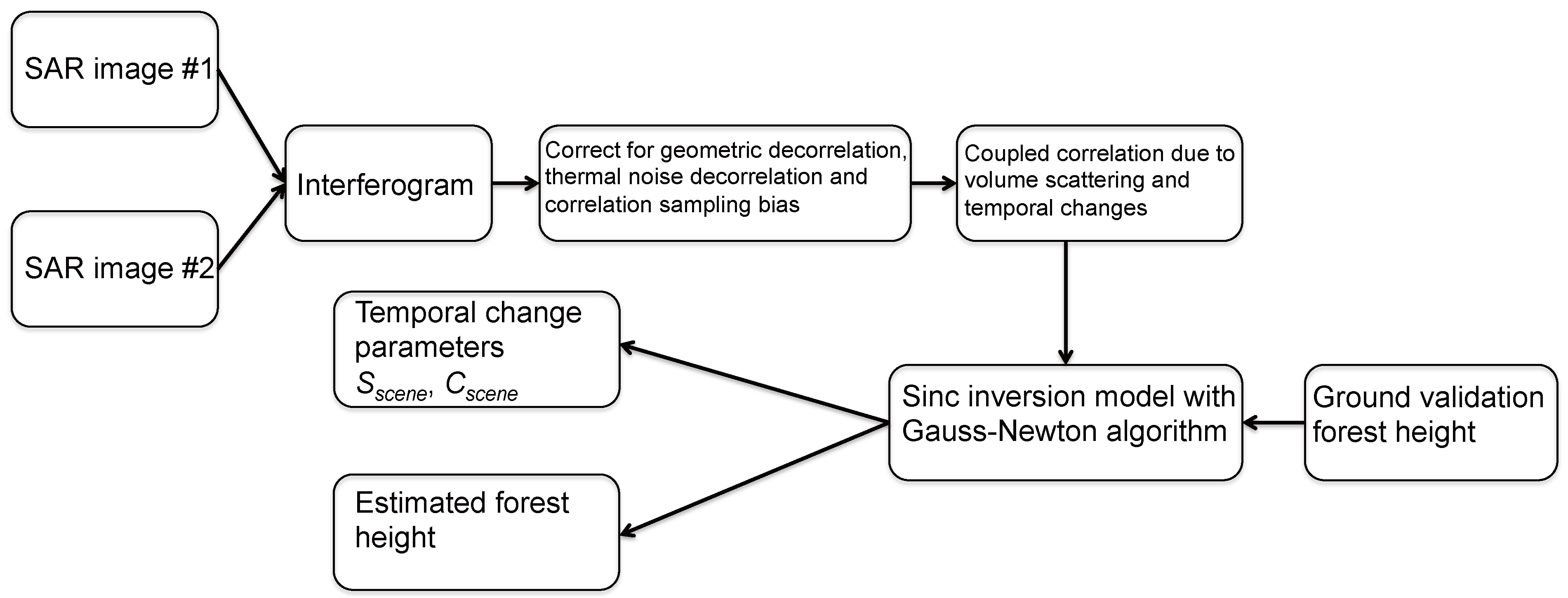
3. Forest Height Inversion Approach

3.1. Simplified Model of |γv&t|
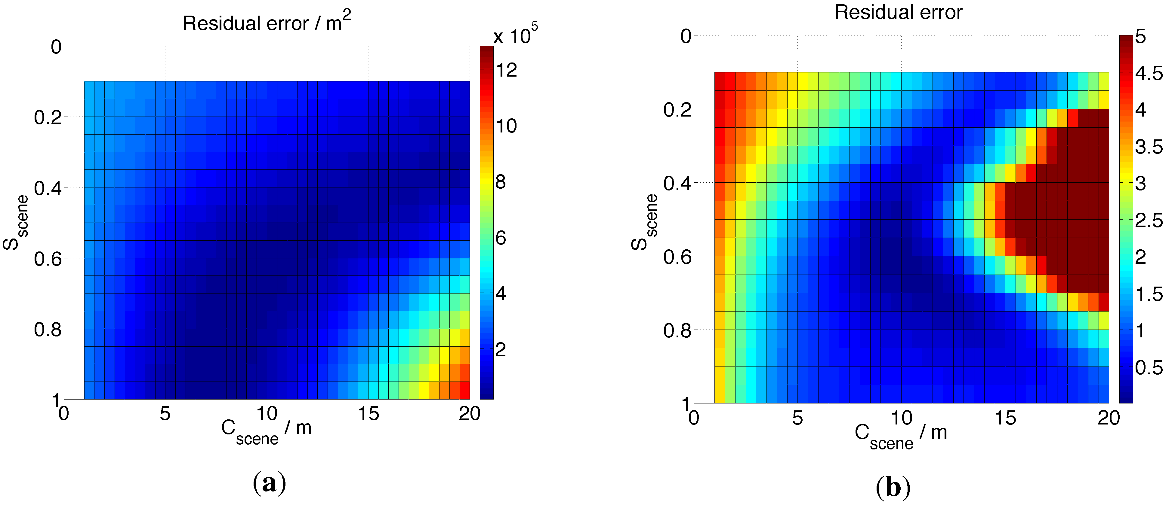
3.2. Forest Height Inversion by Estimating the Fitting Parameters Sscene and Cscene


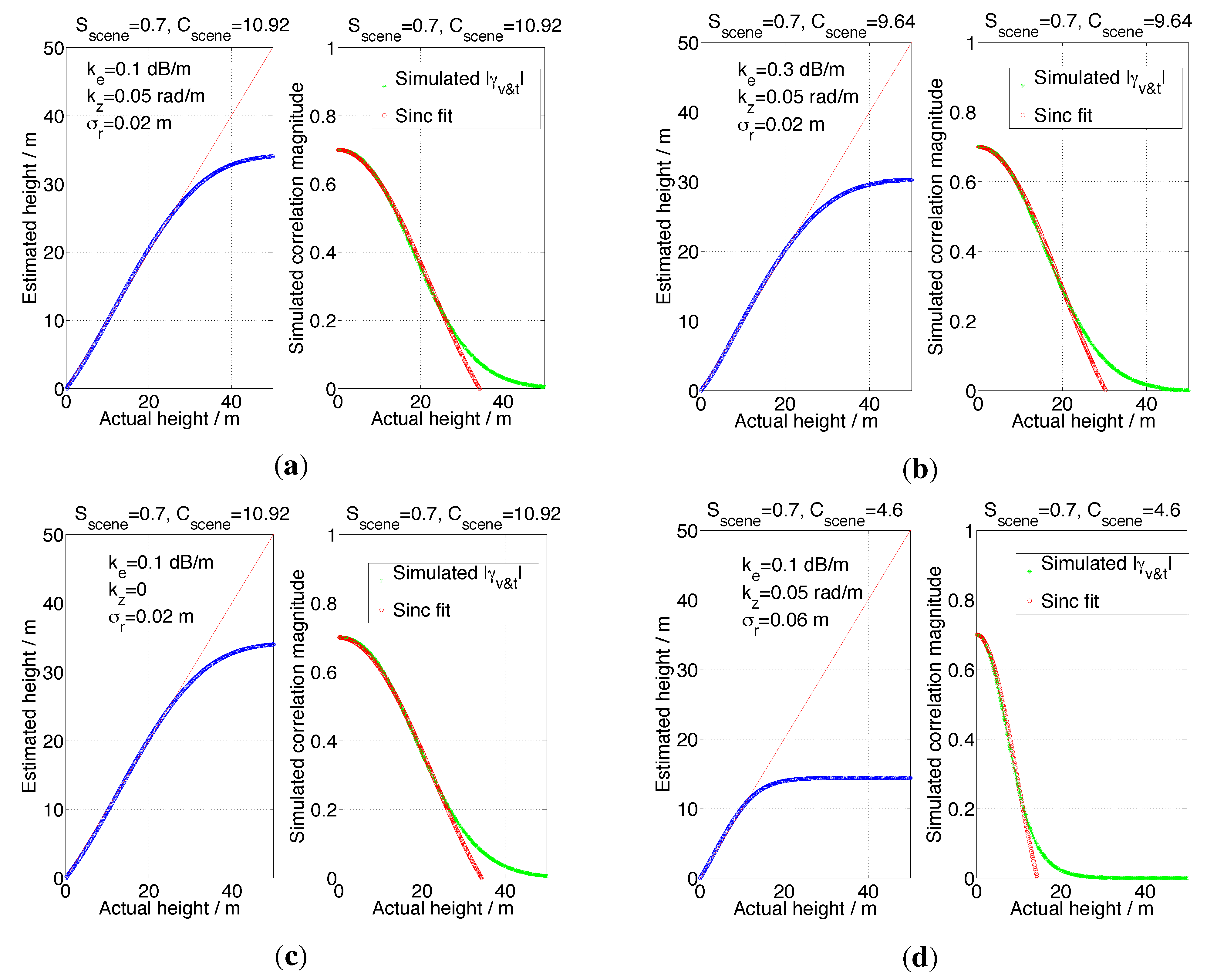
3.3. Simulation Results
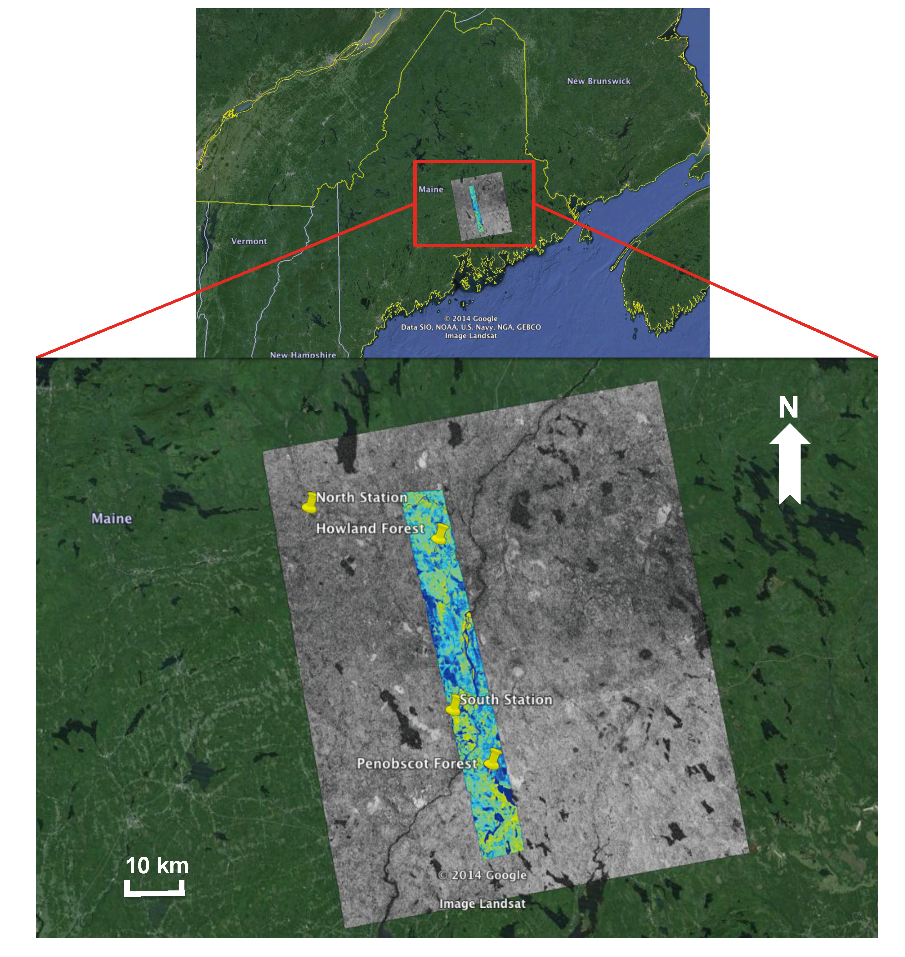
4. Study Area and Experimental Data
4.1. Site Description

4.2. LVIS Lidar Data
4.3. ALOS/PALSAR Data
5. Results and Discussions
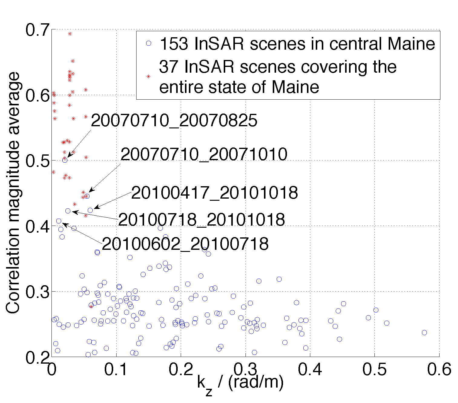
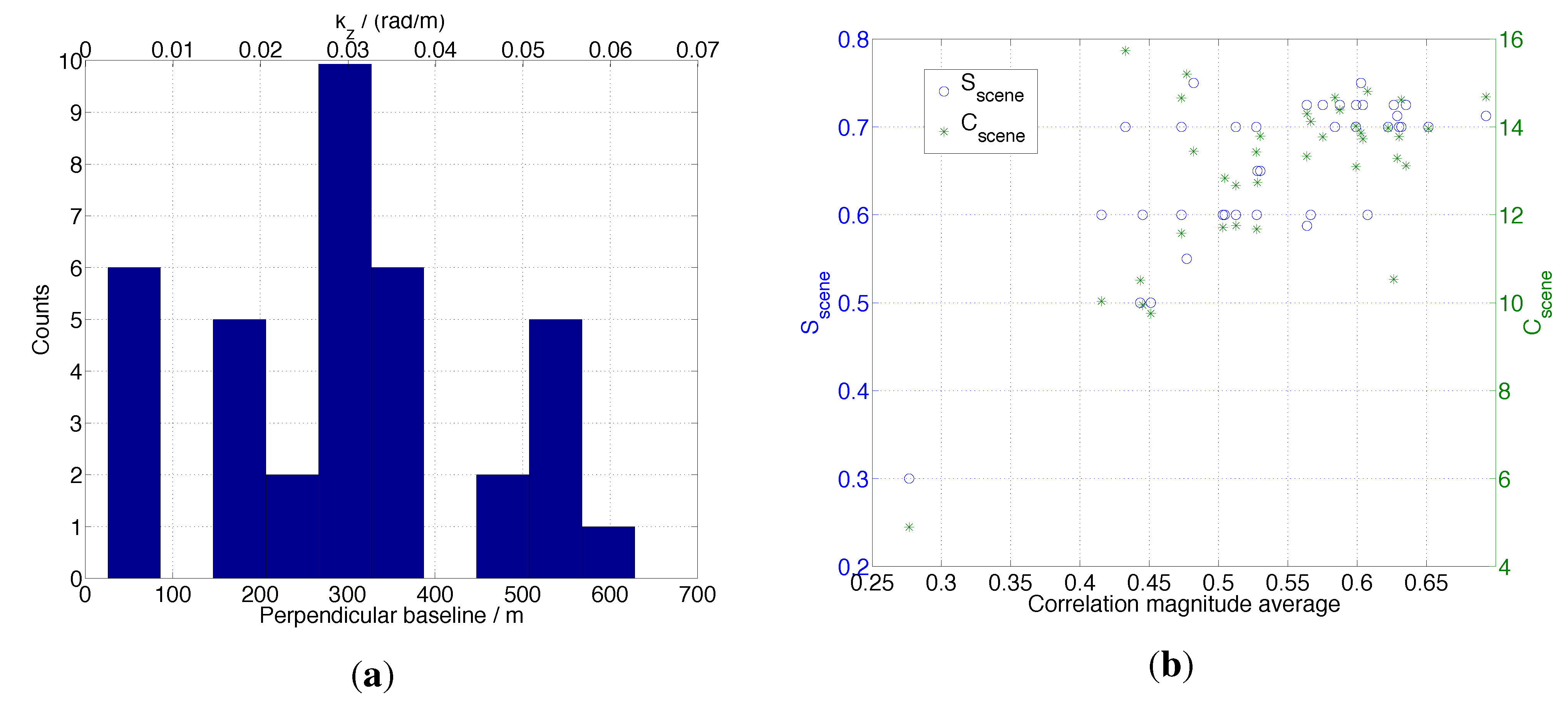
5.1. InSAR Processing

| Collection Date | Data Mode | Precipitation (mm) | 3-Day Accumulated Precipitation (mm) | Temperature (Max/Min; °C) |
|---|---|---|---|---|
| 20070107 | FBS | 7.6 (N) | 20.6 (N) | 12.8/3.3 (N) |
| 0.0 (S) | 16.3 (S) | 6.7/−3.9 (S) | ||
| 20070222 | FBS | 0.0 (N) | 1.3 (N) | 0.0/−15.6 (N) |
| 0.0 (S) | 0.0 (S) | −1.7/−20.6 (S) | ||
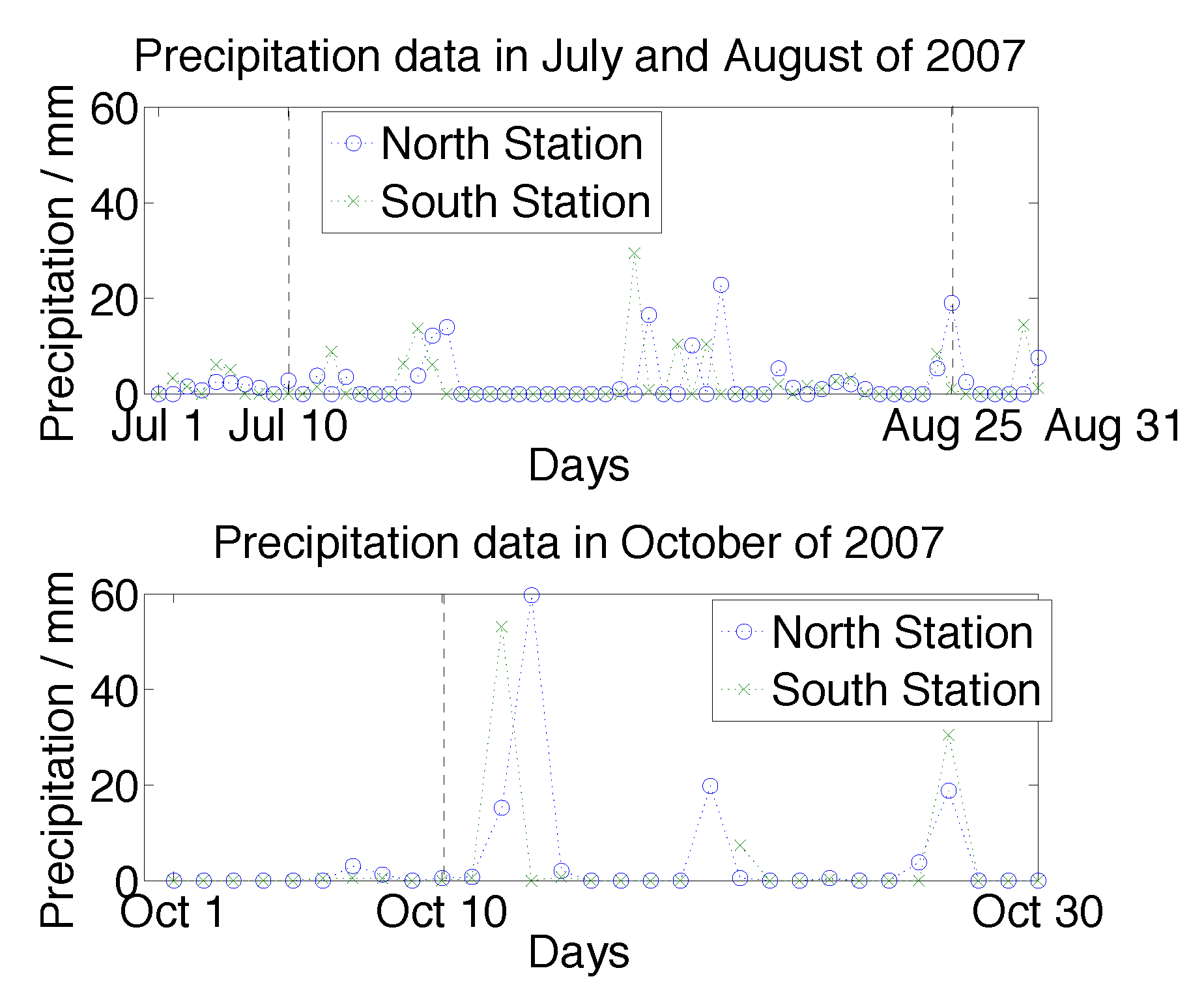
| 20070710 | FBD | 2.8 (N) | 3.3 (N) | 19.4/9.4 (N) |
| 0.0 (S) | 0.0 (S) | 28.9/12.2 (S) | ||
| 20070825 | FBD | 19.1 (N) | 5.3 (N) | 22.2/17.8 (N) |
| 1.0 (S) | 8.4 (S) | 29.4/15 (S) | ||
| 20071010 | FBD | 0.5 (N) | 4.6 (N) | 16.7/3.3 (N) |
| 0.0 (S) | 1.0 (S) | 12.2/7.2 (S) | ||
| 20080110 | FBS | 2.5 (N) | 0.3 (N) | 11.1/2.8 (N) |
| 0.0 (S) | 0.3 (S) | 6.7/−4.4 (S) | ||
| 20080225 | FBS | 0.0 (N) | 3.8 (N) | 3.9/−12.2 (N) |
| 0.0 (S) | 4.3 (S) | 5/−13.3 (S) | ||
| 20080411 | FBS | 0.0 (N) | 0.0 (N) | 12.2/1.1 (N) |
| 0.0 (S) | 0.0 (S) | 11.1/0.6 (S) | ||
| 20080527 | FBD | 0.5 (N) | 2.3 (N) | 22.2/11.1 (N) |
| 0.0 (S) | 0.0 (S) | 26.7/6.7 (S) | ||
| 20080712 | FBD | 0.0 (N) | 8.6 (N) | 24.4/8.9 (N) |
| 0.0 (S) | 0.0 (S) | 26.1/8.3 (S) | ||
| 20090227 | FBS | 0.3 (N) | 0.3 (N) | 2.2/−12.2 (N) |
| 7.6 (S) | 0.0 (S) | 8.9/−6.7 (S) | ||
| 20090830 | FBD | 14.0 (N) | 2.5 (N) | 11.7/10 (N) |
| 0.0 (S) | 51.3 (S) | 21.1/10.6 (S) | ||
| 20091015 | FBD | 0.0 (N) | 9.1 (N) | 7.8/−3.3 (N) |
| 0.0 (S) | 10.2 (S) | 5.6/−3.9 (S) | ||
| 20100417 | FBS | 0.0 (N) | 0.0 (N) | 11.1/0.6 (N) |
| 0.0 (S) | 0.0 (S) | 6.1/2.2 (S) | ||
| 20100602 | FBD | 17.8 (N) | 0.0 (N) | 15.6/12.2 (N) |
| 0.0 (S) | 11.4 (S) | 22.2/12.2 (S) | ||
| 20100718 | FBD | 2.5 (N) | 0.0 (N) | 30.6/16.7 (N) |
| 0.0 (S) | 0.0 (S) | 28.9/17.2 (S) | ||
| 20101018 | FBD | 0.0 (N) | 45.2 (N) | 16.1/4.4 (N) |
| 0.0 (S) | 41.1 (S) | 10/1.1 (S) | ||
| 20110305 | FBS | 0.3 (N) | 1.0 (N) | −1.7/−25 (N) |
| 0.5 (S) | 1.8 (S) | 5.6/−3.3 (S) |

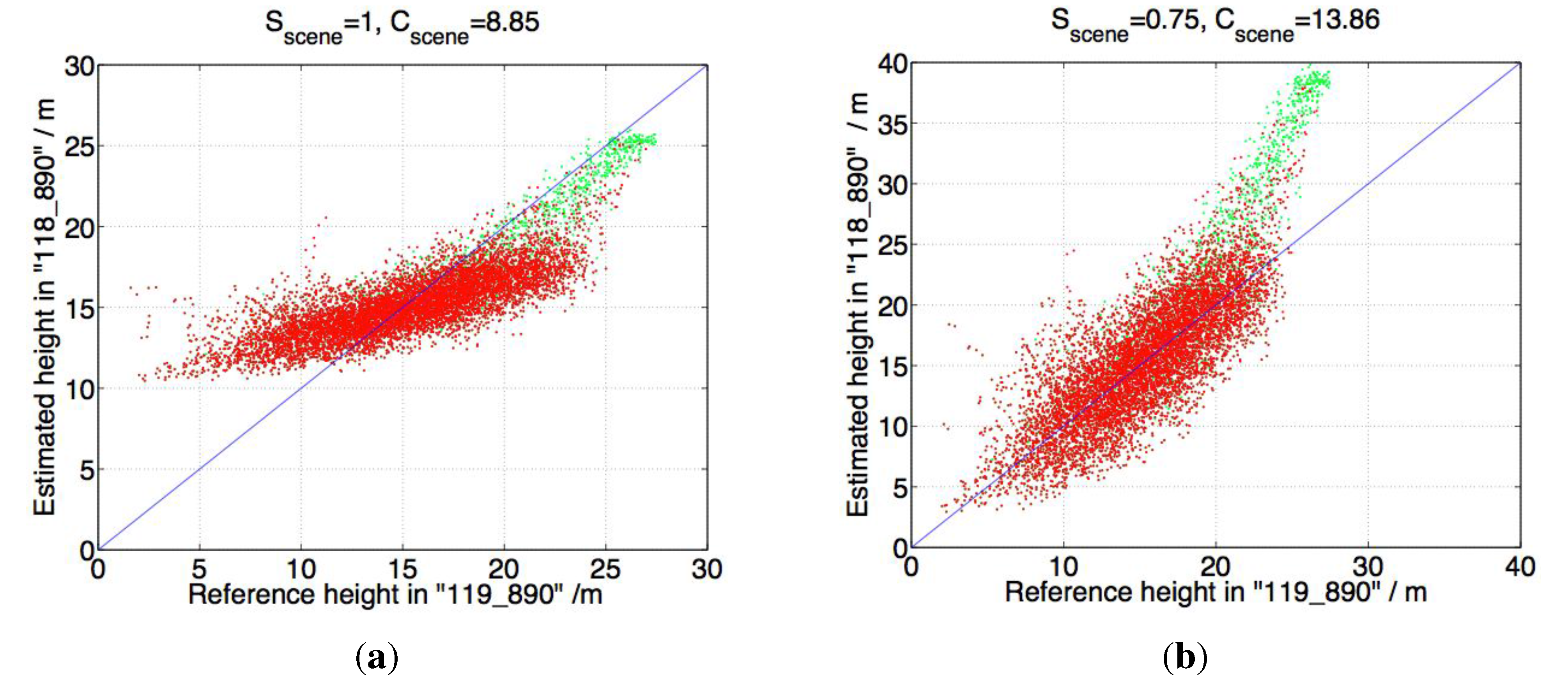
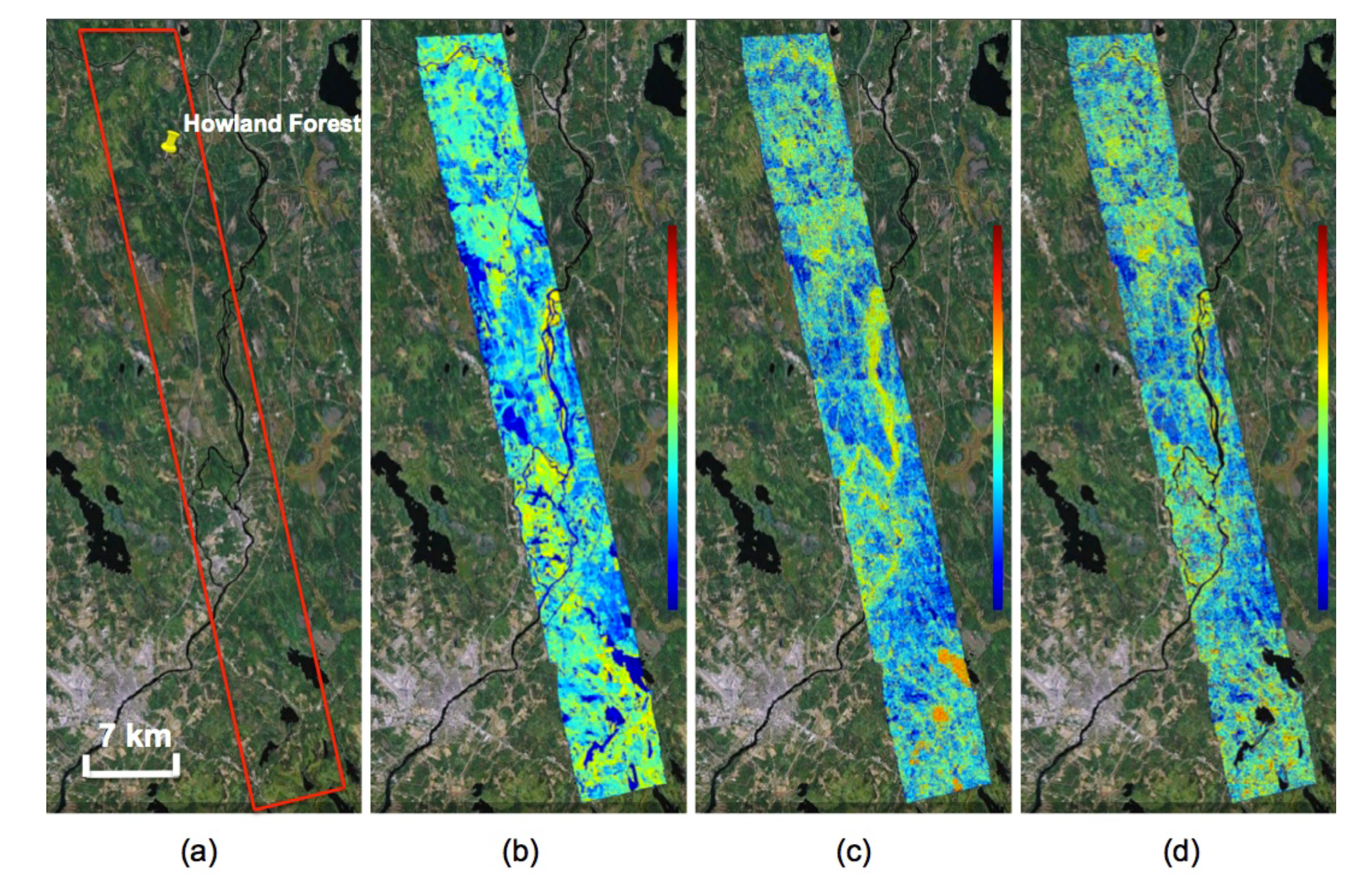
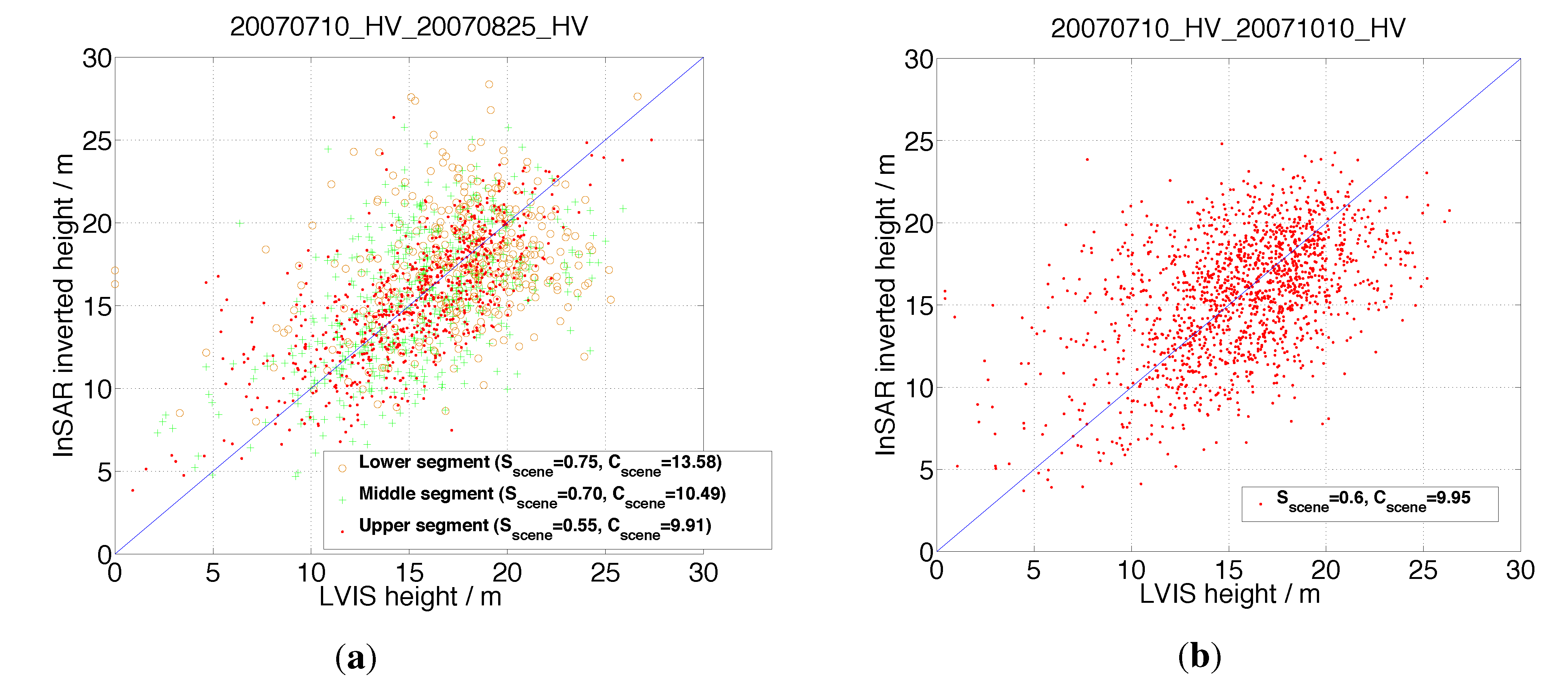
5.2. Forest Height Inversion Model Validation over the Howland Forest
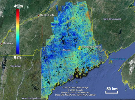
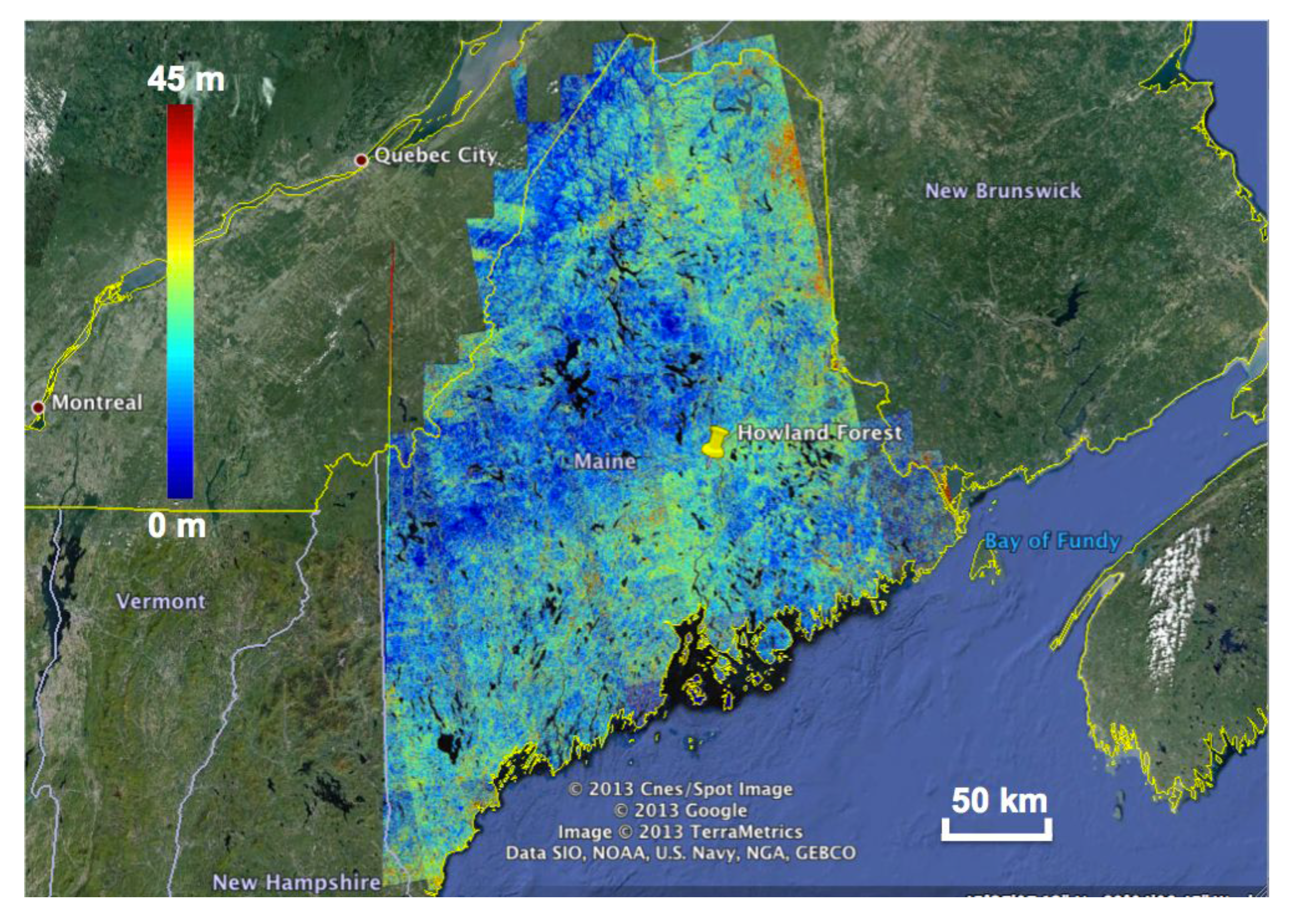
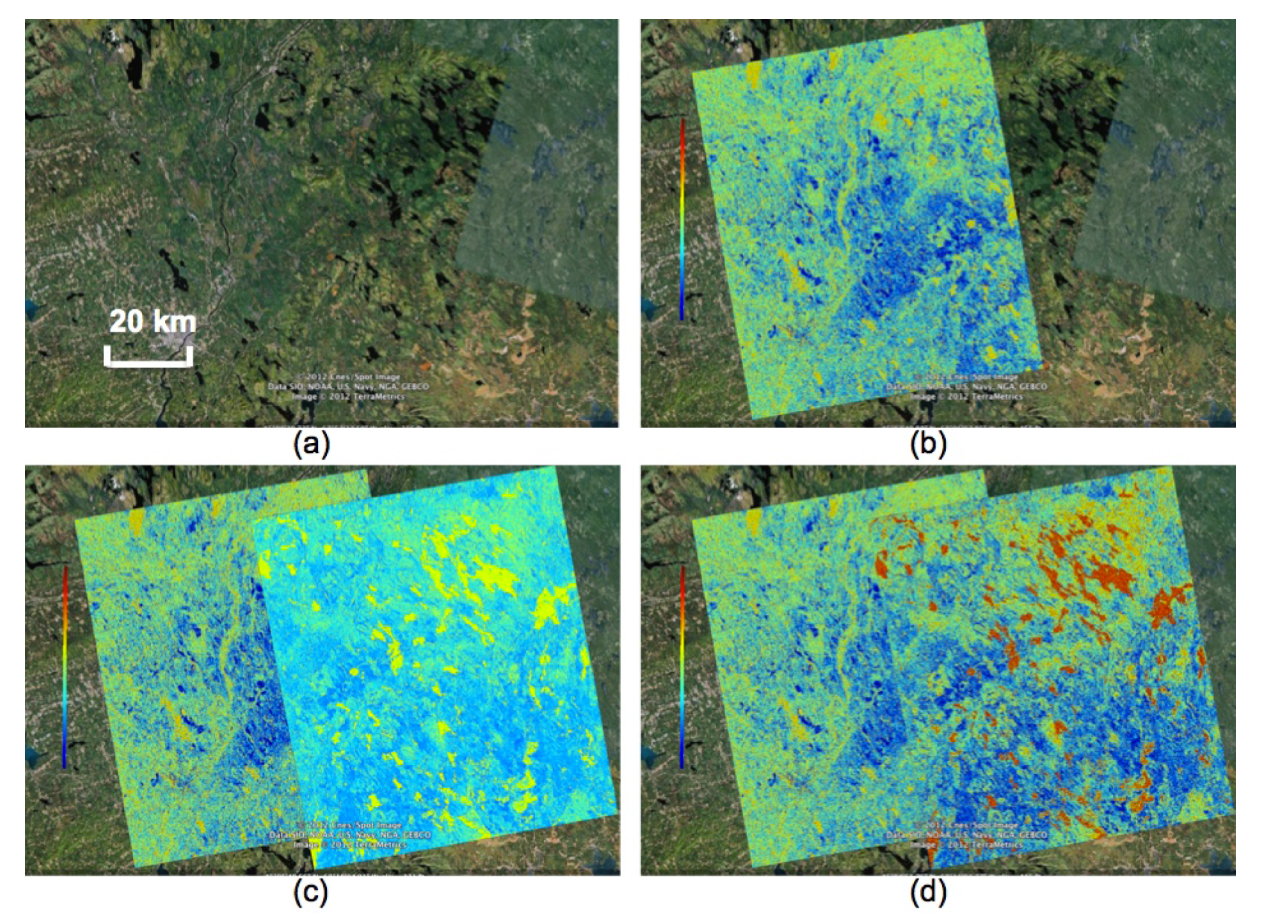
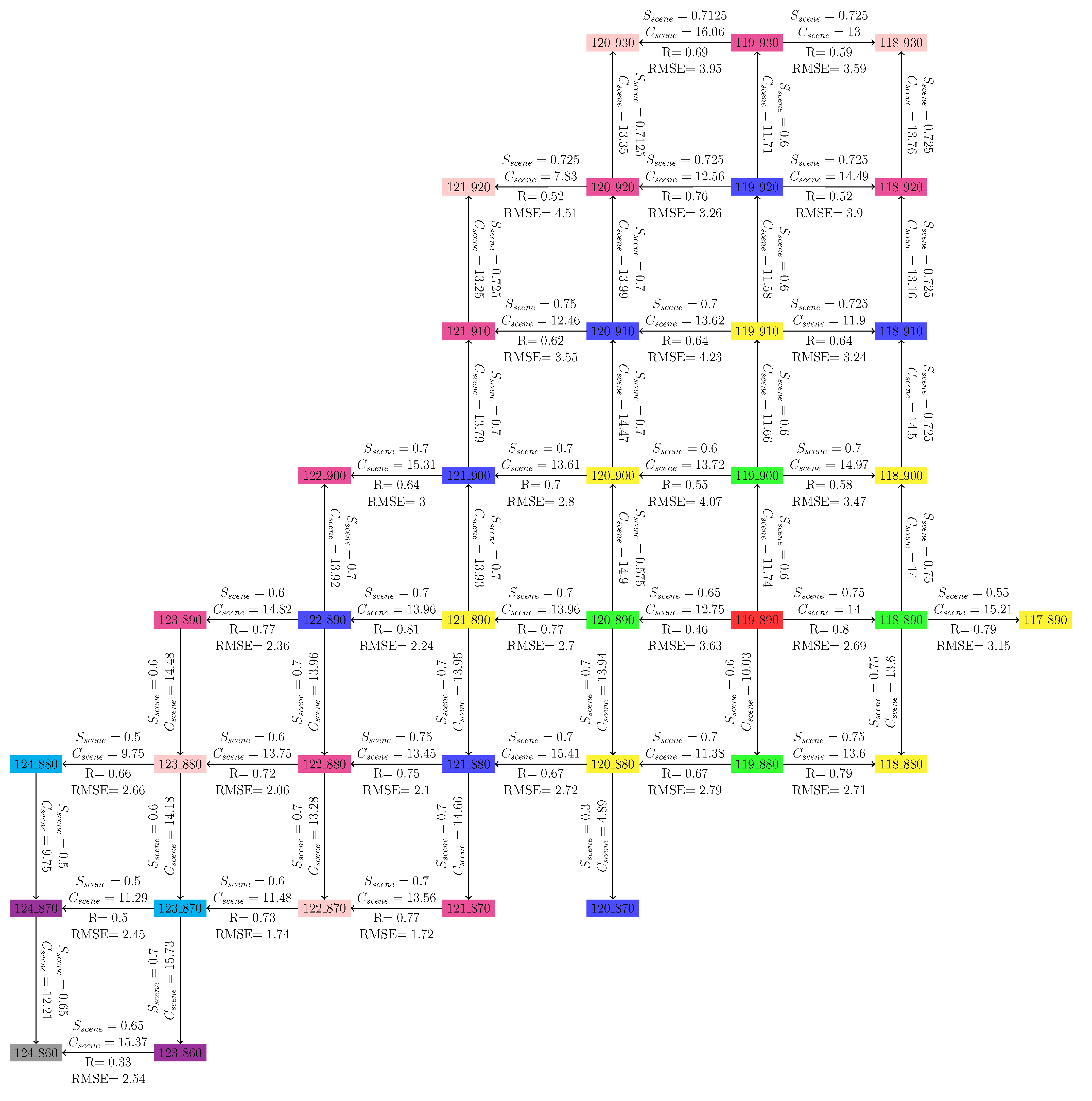
5.3. Forest Height Map Generation for the Entire State of Maine
| Orbit # | 124 | 123 | 122 | 121 | 120 | 119 | 118 | 117 | |
|---|---|---|---|---|---|---|---|---|---|
| Frame # | |||||||||
| 930 | 20070727 | 20070710 | 20070808 | ||||||
| 20070911 | 20070825 | 20070923 | |||||||
| 920 | 20100706 | 20070727 | 20070710 | 20070808 | |||||
| 20100821 | 20070911 | 20070825 | 20070923 | ||||||
| 910 | 20100706 | 20070727 | 20070710 | 20070808 | |||||
| 20100821 | 20070911 | 20070825 | 20070923 | ||||||
| 900 | 20070715 | 20100706 | 20070611 | 20070710 | 20070808 | ||||
| 20070830 | 20100821 | 20070727 | 20070825 | 20070923 | |||||
| 890 | 20070616 | 20070715 | 20100706 | 20070727 | 20070710 | 20070808 | 20070722 | ||
| 20070801 | 20070830 | 20100821 | 20070911 | 20071010 | 20070923 | 20070906 | |||
| 880 | 20070703 | 20070616 | 20070715 | 20100706 | 20070611 | 20070710 | 20070808 | ||
| 20071003 | 20070801 | 20070830 | 20100821 | 20070727 | 20071010 | 20070923 | |||
| 870 | 20070703 | 20070616 | 20100723 | 20100706 | 20070611 | ||||
| 20071003 | 20070801 | 20100907 | 20100821 | 20070911 | |||||
| 860 | 20070818 | 20100809 | |||||||
| 20071003 | 20100924 | ||||||||


6. Summary and Conclusions
Acknowledgments
Author Contributions
Appendix A. The Assumption of Constant Temporal Change Parameters and Forest Backscatter Profile/Extinction Coefficient
Appendix B. Polarization-Dependence of the Forest Height Inversion Procedure
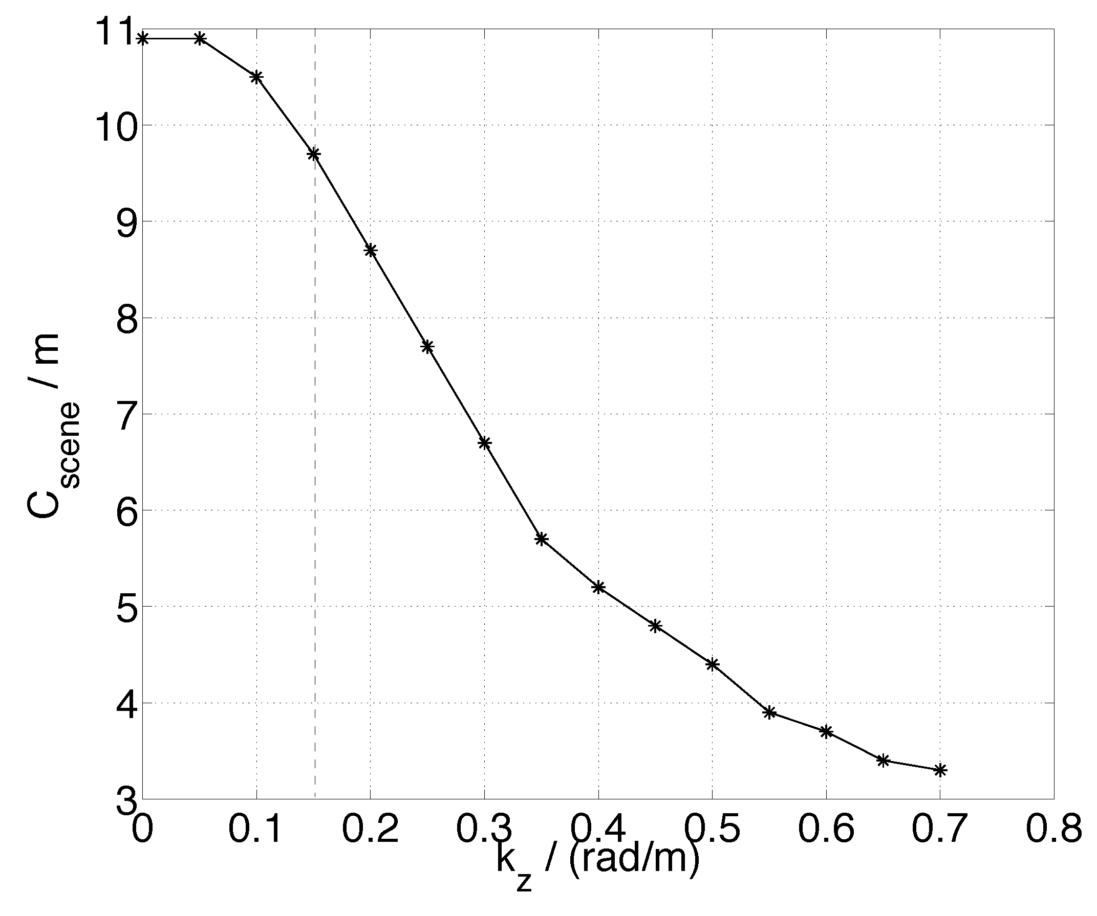
Appendix C. Effective Range of kz for this Work and the Small-kz Assumption

Conflicts of Interest
References
- Goetz, S. The lost promise of DESDynI. Remote Sens. Environ. 2011, 115, 2751. [Google Scholar] [CrossRef]
- Treuhaft, R.; Siqueira, P. Vertical structure of vegetated land surfaces from interferometric and polarimetric radar. Radio Sci. 2000, 35, 141–177. [Google Scholar] [CrossRef]
- Papathanassiou, K.; Cloude, S. Single-baseline polarimetric SAR interferometry. IEEE Trans. Geosci. Remote Sens. 2001, 39, 2352–2363. [Google Scholar] [CrossRef]
- Ahmed, R.; Siqueira, P.; Hensley, S.; Chapman, B.; Bergen, K. A survey of temporal decorrelation from spaceborne L-Band repeat-pass InSAR. Remote Sens. Environ. 2011, 115, 2887–2896. [Google Scholar] [CrossRef]
- Simard, M.; Hensley, S.; Lavalle, M.; Dubayah, R.; Pinto, N.; Hofton, M. An empirical assessment of temporal decorrelation using the uninhabited aerial vehicle synthetic aperture radar over forested landscapes. Remote Sens. 2012, 4, 975–986. [Google Scholar] [CrossRef]
- Lee, S.; Kugler, F.; Papathanassiou, K.; Hajnsek, I. cation and compensation of temporal decorrelation effects in polarimetric SAR interferometry. In Proceedings of the 2012 IEEE International Geoscience and Remote Sensing Symposium (IGARSS), Munich, Germany, 22–27 July 2012; pp. 3106–3109.
- Lee, S.K.; Kugler, F.; Papathanassiou, K.P.; Hajnsek, I. Quantification of temporal decorrelation effects at L-band for polarimetric SAR interferometry applications. IEEE J. Sel. Top. Appl. Earth Obs. Remote Sens. 2013, 6, 1351–1367. [Google Scholar] [CrossRef]
- Askne, J.I.; Dammert, P.B.; Ulander, L.M.; Smith, G. C-band repeat-pass interferometric SAR observations of the forest. IEEE Trans. Geosci. Remote Sens. 1997, 35, 25–35. [Google Scholar] [CrossRef]
- Lavalle, M.; Simard, M.; Hensley, S. A temporal decorrelation model for polarimetric radar interferometers. IEEE Trans. Geosci. Remote Sens. 2012, 50, 2880–2888. [Google Scholar] [CrossRef]
- Askne, J.; Santoro, M.; Smith, G.; Fransson, J.E. Multitemporal repeat-pass SAR interferometry of boreal forests. IEEE Trans. Geosci. Remote Sens. 2003, 41, 1540–1550. [Google Scholar] [CrossRef]
- Thiel, C.; Schmullius, C. Investigating ALOS PALSAR interferometric coherence in central Siberia at unfrozen and frozen conditions: Implications for forest growing stock volume estimation. Can. J. Remote Sens. 2013, 39, 232–250. [Google Scholar] [CrossRef]
- Hajnsek, I.; Kugler, F.; Lee, S.; Papathanassiou, K. Tropical-forest-parameter estimation by means of Pol-InSAR: The INDREX-II campaign. IEEE Trans. Geosci. Remote Sens. 2009, 47, 481–493. [Google Scholar] [CrossRef]
- Papathanassiou, K.; Cloude, S.R. effect of temporal decorrelation on the inversion of forest parameters from PoI-InSAR data. In. In Proceedings of the International Geoscience and Remote Sensing Symposium,, Toulouse, France, 21–25 July 2003.
- Lavalle, M.; Hensley, S. onstration of repeat-pass POLINSAR using UAVSAR: The RMOG model. In Proceedings of the 2012 IEEE International Geoscience and Remote Sensing Symposium (IGARSS), Munich, Germany, 22–27 July 2012; pp. 5876–5879.
- Cloude, S.; Papathanassiou, K. Three-stage inversion process for polarimetric SAR interferometry. IEE Proc.-Radar Sonar Navig. 2003, 150, 125–134. [Google Scholar] [CrossRef]
- Touzi, R.; Lopes, A.; Bruniquel, J.; Vachon, P. Coherence estimation for SAR imagery. IEEE Trans. Geosci. Remote Sens. 1999, 37, 135–149. [Google Scholar] [CrossRef]
- Cloude, S.R. Polarization coherence tomography. Radio Sci. 2006, 41. [Google Scholar] [CrossRef]
- Moon, T.K.; Stirling, W.C. Mathematical Methods and Algorithms for Signal Processing; Prentice Hall: New York, NY, USA, 2000. [Google Scholar]
- Heath, M.T. Scientific Computing: An Introductory Survey; The McGraw-Hill Companies Inc.: New York, NY, USA, 2002. [Google Scholar]
- NOAA’s National Climatic Data Center. Available online: http://ncdc.noaa.gov (accessed on 22 October 2014).
- Hollinger, D.; Goltz, S.; Davidson, E.; Lee, J.; Tu, K.; Valentine, H. Seasonal patterns and environmental control of carbon dioxide and water vapour exchange in an ecotonal boreal forest. Glob. Chang. Biol. 1999, 5, 891–902. [Google Scholar] [CrossRef]
- Sendak, P.E.; Brissette, J.C.; Frank, R.M. Silviculture affects composition, growth, and yield in mixed northern conifers: 40-year results from the Penobscot Experimental Forest. Can. J. For. Res. 2003, 33, 2116–2128. [Google Scholar] [CrossRef]
- Blair, J.; Rabine, D.; Hofton, M. The laser vegetation imaging sensor: A medium-altitude, digitisation-only, airborne laser altimeter for mapping vegetation and topography. ISPRS J. Photogramm. Remote Sens. 1999, 54, 115–122. [Google Scholar] [CrossRef]
- Shimada, M.; Isoguchi, O.; Tadono, T.; Isono, K. PALSAR radiometric and geometric calibration. IEEE Trans. Geosci. Remote Sens. 2009, 47, 3915–3932. [Google Scholar] [CrossRef]
- Rosenqvist, A.; Shimada, M.; Ito, N.; Watanabe, M. ALOS PALSAR: A pathfinder mission for global-scale monitoring of the environment. IEEE Trans. Geosci. Remote Sens. 2007, 45, 3307–3316. [Google Scholar] [CrossRef]
- Werner, C.; Wegmüller, U.; Strozzi, T.; Wiesmann, A.; Santoro, M. R multi-mode interferometric processing. In Proceedings of the 1st Joint PI Symposium of ALOS Data Nodes, Kyoto, Japan, 19–23 November 2007; pp. 19–23.
- Gatelli, F.; Guamieri, A.M.; Parizzi, F.; Pasquali, P.; Prati, C.; Rocca, F. The wavenumber shift in SAR interferometry. IEEE Trans. Geosci. Remote Sens. 1994, 32, 855–865. [Google Scholar] [CrossRef]
- Schwabisch, M.; Geudtner, D. Improvement of phase and coherence map quality using azimuth prefiltering: Examples from ERS-1 and X-SAR. In Proceedings of the IEEE International Geoscience and Remote Sensing Symposium, IGARSS’95, Florence, Italy, 10–14 July 1995; Volume 1, pp. 205–207.
- Zebker, H.A.; Villasenor, J. Decorrelation in interferometric radar echoes. IEEE Trans. Geosci. Remote Sens. 1992, 30, 950–959. [Google Scholar] [CrossRef]
- Fry, J.; Xian, G.; Jin, S.; Dewitz, J.; Homer, C.; Yang, L.; Barnes, C.; Herold, N.; Wickham, J. Completion of the 2006 national land cover database for the counterminous United States. Photogramm. Eng. Remote Sens. 2011, 77, 858–864. [Google Scholar]
- Siqueira, P.; Hensley, S.; Shaffer, S.; Hess, L.; McGarragh, G.; Chapman, B.; Freeman, A. A continental-scale mosaic of the Amazon Basin using JERS-1 SAR. IEEE Trans. Geosci. Remote Sens. 2000, 38, 2638–2644. [Google Scholar] [CrossRef]
© 2014 by the authors; licensee MDPI, Basel, Switzerland. This article is an open access article distributed under the terms and conditions of the Creative Commons Attribution license (http://creativecommons.org/licenses/by/3.0/).
Share and Cite
Lei, Y.; Siqueira, P. Estimation of Forest Height Using Spaceborne Repeat-Pass L-Band InSAR Correlation Magnitude over the US State of Maine. Remote Sens. 2014, 6, 10252-10285. https://doi.org/10.3390/rs61110252
Lei Y, Siqueira P. Estimation of Forest Height Using Spaceborne Repeat-Pass L-Band InSAR Correlation Magnitude over the US State of Maine. Remote Sensing. 2014; 6(11):10252-10285. https://doi.org/10.3390/rs61110252
Chicago/Turabian StyleLei, Yang, and Paul Siqueira. 2014. "Estimation of Forest Height Using Spaceborne Repeat-Pass L-Band InSAR Correlation Magnitude over the US State of Maine" Remote Sensing 6, no. 11: 10252-10285. https://doi.org/10.3390/rs61110252
APA StyleLei, Y., & Siqueira, P. (2014). Estimation of Forest Height Using Spaceborne Repeat-Pass L-Band InSAR Correlation Magnitude over the US State of Maine. Remote Sensing, 6(11), 10252-10285. https://doi.org/10.3390/rs61110252