1. Introduction
Global warming is known as one of the biggest environmental issues of the 21st century. Many studies have been made and conferences held, emphasizing the importance of this issue and the associated problems. World nations are working together on policies, not only for preventing the problem, but mostly for mitigating its impacts [
1–
3]. Japan is one of the top nations involved in activities related to this issue, and the Kyoto Protocol (adopted at the Kyoto Conference in 1997), provided new approaches to finding solutions [
4], among which are the Clean Development Mechanism (CDM), Emission Trading, Joint Implementation (JI) and Carbon Sink. Carbon sink is the focal point in the present research context, as 68.9% of land in Japan are covered by forests [
5]. Japan is considering the forests to be the top candidate for its CO
2 reduction process [
6]. Many prefectures in Japan have been researching carbon sequestration by forests and have come up with various policies for reducing CO
2. However, some prefectures have not yet been involved in such processes focusing on CO
2 reduction through carbon sink, notwithstanding the large amount of their forest cover. Oita Prefecture is one of them.
The Oita Prefecture government has so far focused on energy conservation as the main mechanism for effectively reducing its CO
2 emissions [
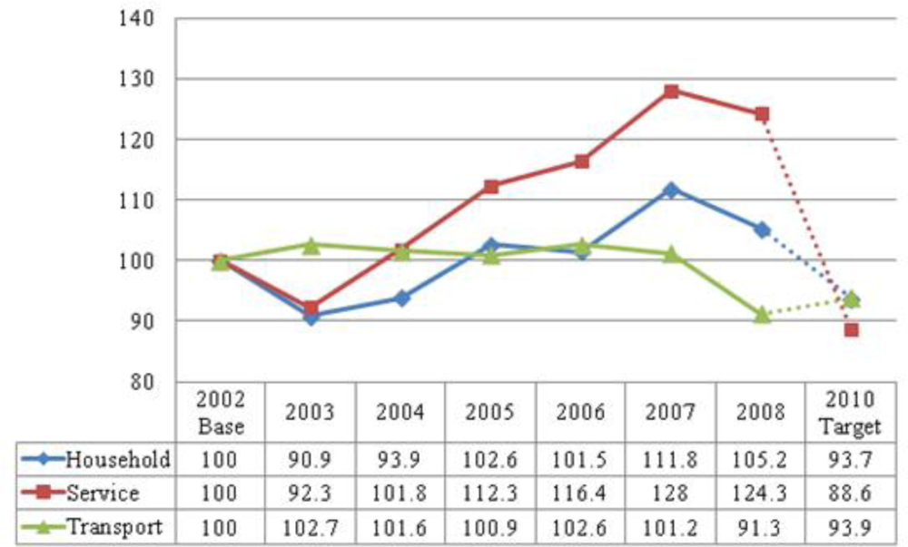
7]. Oita Prefecture’s global warming measure implementation started in 2005; it aimed at reducing energy consumption and wastes, and introducing more energy-efficient (cogeneration) systems. The result of this approach (
Figure 1, [
8]) does not seem to be as effective as claimed by the government. There is thus the need to reconsider this regulation and the tools used for its implementation toward the goals. Thus far, Oita Prefecture has not focused on the concept of carbon sinks for reducing its CO
2 emissions, and information is only marginally available. This is more likely because of the lack of sound scientific data needed for objective decision making about which process to use for effectively implementing the CO
2 reduction policy in the long term.
Traditional methods of estimating carbon/CO
2 sequestration through site-based methods [
9,
10] or using eddy covariance flux tower are known to be expensive, time consuming and limited in area coverage. Expanding the area or implementing continuous monitoring is even more costly and time consuming. Remotely sensed satellite observations have provided the scientists with an alternative method for studying the earth’s biosphere (atmosphere, vegetation,
etc.). As for the vegetation, it has been demonstrated that the reflected RGB (red, green, blue), and mostly the NIR (near infrared), wavelengths contain considerable information about plants biomass [
11], from which precise knowledge about the vegetation can be extracted. This gives us the possibility of biomass monitoring at lower costs and with less time loss. Today, with further research advancement, remote sensing is becoming a common analysis tool, not only for producing maps needed for categorizing the land cover type of the surface and for allocating or managing the earth’s resources [
12], but also for analyzing the changes and their impacts for future land use/land cover (LU/LC) developments [
13].
Using remote sensing data for evaluating regional carbon/CO
2 sequestration has been implemented in various ways, among which is combining the land cover information with the averaged carbon sequestration values of different land cover types [
14]. The strength of using land cover information based on remotely sensed images is that it covers areas of regional or even global scales, making it possible to extend analysis over sites that are difficult to access on the ground. Moreover, it allows the implementation of continuous monitoring of the area, making it possible to analyze the temporal changes of the land cover.
Estimates of sequestration by forests in Japan are usually implemented at the national scale (whole Japan), focusing mostly on identifying forests as natural or planted forests. Hiroshima and Nakajima [
15] focused on the potential carbon sinks in Japanese planted forests during the first commitment period of the Kyoto Protocol. Using subsidies and forest workers’ wages as predictor variables, they estimated that the privately planted forests were sequestering 8.16–8.87 MtC/yr, depending on the different scenarios of forest management and silvicultural practices. Sasaki and Kim [
16] estimated both the potential and the eligible sequestrations by the forests in Japan under the condition of the Marrakesh Accords. Using the land use and the carbon stock growth models, they estimated that the forests in Japan were likely to sequester 20.1 MtC/yr (planted forests: 15.3 MtC/yr; natural forests: 4.8 MtC/yr), while under the Marrakesh Accords scheme, this was estimated to be 10.2 MtC/yr (planted forests: 7.3 MtC/year; natural forests: 2.9 MtC/yr). In general, few studies have estimated the potential of CO
2 sequestration by the forests in Japan, and only fewer considered to perform the analysis at local or regional scales, focusing more on detailed forest types. This can be easily understood: the Kyoto Protocol deals with national level estimates, so many studies are involved in the estimates at that scale.
However, we have to note that the estimates by those authors mentioned above are based on modeling, while the information of where and how much of those resources exist is not considered. This is a serious weakness, especially when forest resources management is concerned. Moreover, we also have to consider that forests are more diverse than just being natural or planted forests. Because both tree types and tree ages make differences in CO
2 sequestration [
9,
17,
18], and for a more realistic estimation of the sequestration, we emphasize that forests have to be analyzed on a local or regional scale in order to get more precise and detailed classes for each forest category (tree type) as well as for each tree age range. Based on this detailed information about the forests, precise estimates of the forests sink capacity can be obtained. This is also a way of providing reliable information for sound decision making for sustainable forest management and development.
The objective of this research is to estimate CO2 sequestration by forests type in Oita Prefecture, based on precise evaluation of forests extent in Oita. This will make it possible to quantitatively estimate their potential storage capacity, and therefore maximize the usage of this environmental resource as a CO2 sink. These findings will help the Oita Prefecture g to devise better scenarios for mitigating global warming. Local and regional scale analysis of the land cover and estimation of CO2 sequestration will eventually contribute to the updated information of Japan’s CO2 reduction target achievement.
The study site, datasets and methodology are presented in Sections 2–4, respectively. Geographic Information Systems (GIS) and remote sensing technology are used for the analysis. The analysis results are given in Section 5, followed by discussion in section 6 and concluding remarks in Section 7.
2. Study Site
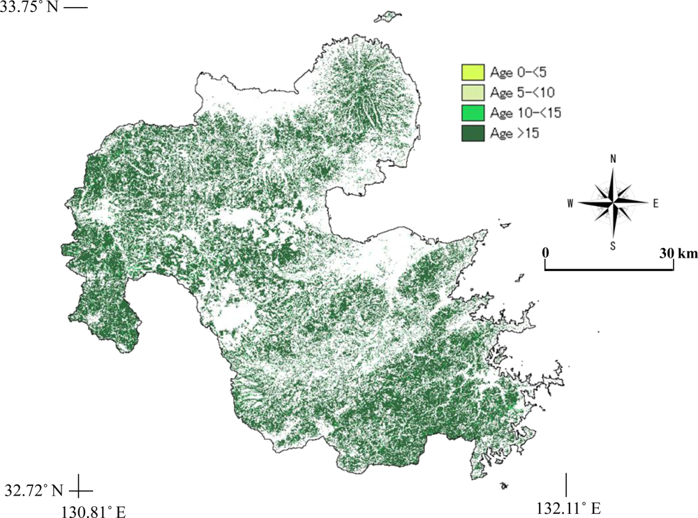
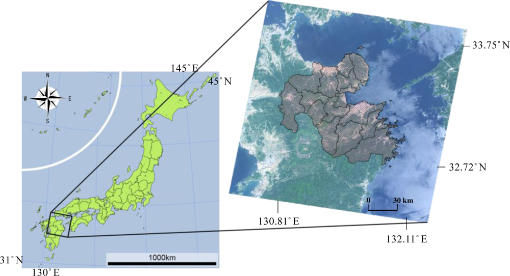
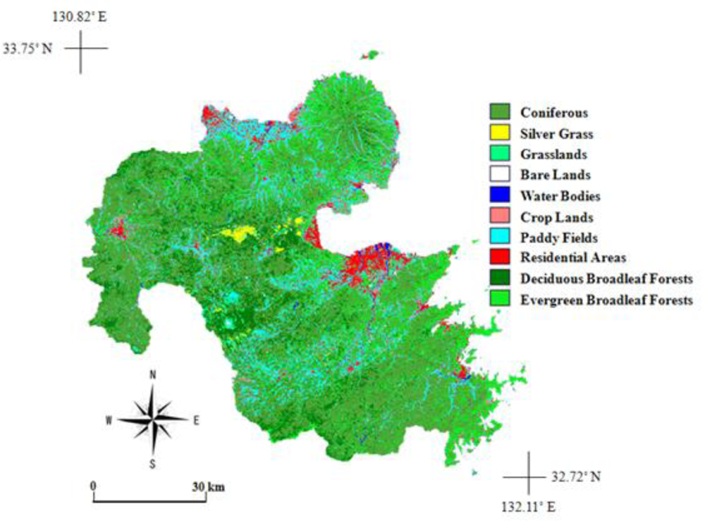
The research area, Oita Prefecture, is located on the Kyushu Island in the southwestern part of Japan (
Figure 2), between 130.81°E and 132.11°E, 32.72°N and 33.75°N, with a total land area of 6,339 km
2. Official figures show that 4,540 km
2 (or 72%) of Oita Prefecture’s lands are covered by forests [
19].
Oita Prefecture is also known for its rich and diversified Onsen (hot springs), found especially in Beppu City. A volcanic belt (the Kirishima Volcanic Range), with several mountains ranges, culminating up to 1,758 m in altitude, runs from north to south through the prefecture, contributing to the existence of the many hot springs.
Climatic conditions divide the prefecture in two main areas: (1) the area affected by the monsoon winds coming from the coast of the Japan Sea, and bringing in large amounts of rainfall and large number of rainy days in winter, and (2) the area characterized by large amounts of rains in summer resulting from the moisture flowing in from the Pacific Ocean, and by dry and fine weathers in winter. Because of these wet climate conditions, annual rainfall in Oita Prefecture ranges from 1,500–1,600 mm over coastal areas, to 2,500–3,000 mm in the mountainous areas.
3. Data Sets
Two optical satellite data sets from the Land Remote Sensing Satellite Enhanced Thematic Mapper, Plus (LANDSAT ETM+) with 30 m spatial resolution published by the United States Geological Survey (USGS) and two microwave satellite data sets from the Advanced Land Observing Satellite (ALOS) Phased Array L-band Synthetic Aperture Radar (PALSAR) provided by Japan Aerospace Exploration Agency (JAXA), were selected for our analytical objectives. The selection of the data sets was done by considering the following three critical issues. First, we had to choose a cloud-free image for analysis. In fact, clouds block the solar radiation from reaching the ground, rendering the covered area unavailable for the optical observing platform. Second, the Scan Line Corrector (SLC) failure that occurred after 31 May 2003 makes the LANDSAT ETM+ line of sight trace a zigzag pattern along the satellite ground track. As a result, a gap fill has to be performed in order to correct the data so as to become usable for analysis [
20]. Third, we had to select an image old enough for us to create a digital LU/LC map (or digital vegetation model, here after DVM) of Oita Prefecture that could be used later on as a reference digital map for further quantitative LU/LC change analysis in this area. As a result, we selected the cloud-free LANDSAT ETM+ images captured on 25 May 2002, and 30 December 2006.
For the microwave data, we chose the level 1.5 product of ALOS PALSAR L-band data of 15 September 2009 and 14 October 2009, to cover the study area with an ascending Fine Beam Dual (FBD) Polarization, characterized by 34.3 degree of off nadir angle and 12.5 m of ground range pixel spacing, as the best fit for our analysis purposes.
The National Survey on the Natural Environment [
21], published by the Ministry of Environment of Japan, provides the status of lands, surface waters and coastal areas all over the nation. The survey results are compiled and published in the form of written reports, downloadable maps,
etc. The vegetation map so provided is utilized for identifying specific LU/LC sites for ground truth training data needed for land features classification and for the accuracy assessment of the classified images. Field observations were also performed for collecting additional ground truth data and for the identifying land features for the selected sites all over the prefecture.
For the correction of the remote sensing data, we utilized the digital model of terrain surface published by the Earth Remote Sensing Data Analysis Center (ERSDAC) available from the Advanced Spaceborne Thermal Emission and Reflection Radiometer (ASTER) Global Digital Elevation Model (GDEM) with a spatial resolution of 30 m and an elevation accuracy of ±7 m. The data were downloaded from the websites and concatenated so as to cover the study area and to make them ready for further use in the analysis.
4. Analysis Method
First, gap fill was performed before the correction of the images for the LANDSAT data using the NASA Goddard Space Flight Center frame and fill tool [
22]. Then, the Integrated Radiometric Correction (IRC) method developed by Kobayashi and Sanga-Ngoie [
23] was applied to the selected LANDSAT ETM+ images in order to correct the radiometric distortions caused by both the topography and the atmosphere, so as to obtain the actual (corrected) irradiance value. The IRC method is a comprehensive radiometric correction method aimed at simultaneous correction of atmospheric, solar, and topographic effects inherent to remote sensing data. The IRC makes it possible to retrieve the at-surface reflectance and radiance values as if the atmosphere were totally transparent and the underlying surface absolutely flat, using
where,
Lg is the corrected radiance from the surface;
Ls* is the at-satellite observed spectral radiance from a sloped terrain and
Lh is the upwelling atmospheric spectral radiance also known as haze;
A is the topographic correction factor;
Tr and
Tw are atmospheric transmittance functions: Rayleigh scattering transmittance function (
Tr) and water vapor transmittance function (
Tw). The Dark Object Subtraction Method (DOSM) was used for the removal of haze (
Lh). Haze values were computed for each band using the reflectance values over deep water areas selected as areas of known zero reflectance in the image [
24].
Table 1 shows the computed haze values for each band. The decrease of haze values with increasing wavelengths is remarkable.
A hybrid classification method [
25,
26] is used here in the classification process for producing the digital LU/LC map of Oita. Sanga-Ngoie [
27] stressed on the need to produce a detailed digital LU/LC map or DVM, especially for the vegetation categories, in order to obtain more precise estimations of CO
2 sequestration values. Here, the May data will be the main data set for the analysis while the December data and the PALSAR data will be supplemental data for additional information to the classification/reclassification process so as to produce more detailed land cover maps.
For more precise estimation of CO
2 sequestration, the PALSAR data were used for estimating stem volume, from which the information about tree age could be deduced. The PALSAR Digital Number (DN) values were converted to the backscattering intensity (
σ0) in decibel units using
Equation (2),
where CF is the calibration factor for the PALSAR products, for the level 1.5 product CF = −83.0 dB [
28]. For a correct interpretation of the backscatter signatures, corrections for the effect of local incidence angle and normalization for the true pixel area were necessary. The corrected backscatter in gamma nought (
γ0) format can be obtained from the sigma nought (
σ0) value (
Equation (3)) according to Castel
et al.[
29] and Ulander [
30]. This approach has also been applied by other authors [
31–
34].
where
θloc and
θref represent the local incidence angle and a reference angle for the normalization of the backscatter (e.g., off nadir angle), respectively.
Aslope and
Aflat represent the true pixel area and the local pixel area for a theoretically flat terrain, respectively. For bare surfaces, the exponent
n is equal to 1. For vegetated surfaces,
n expresses the variation of the scattering mechanism due to the presence of a volume on the sloped terrain. It is thus being related to the optical depth of the vegetation, and is estimated to be lower than or equal to 0.36 for the Japanese Earth Resources Satellite-1 (JERS-1) L-band SAR backscatter. We opted to use the 0.36 value, because the scattering properties of the forests should be taken into account. For future works, more precise estimates should be reconsidered, especially in the case of different polarizations.
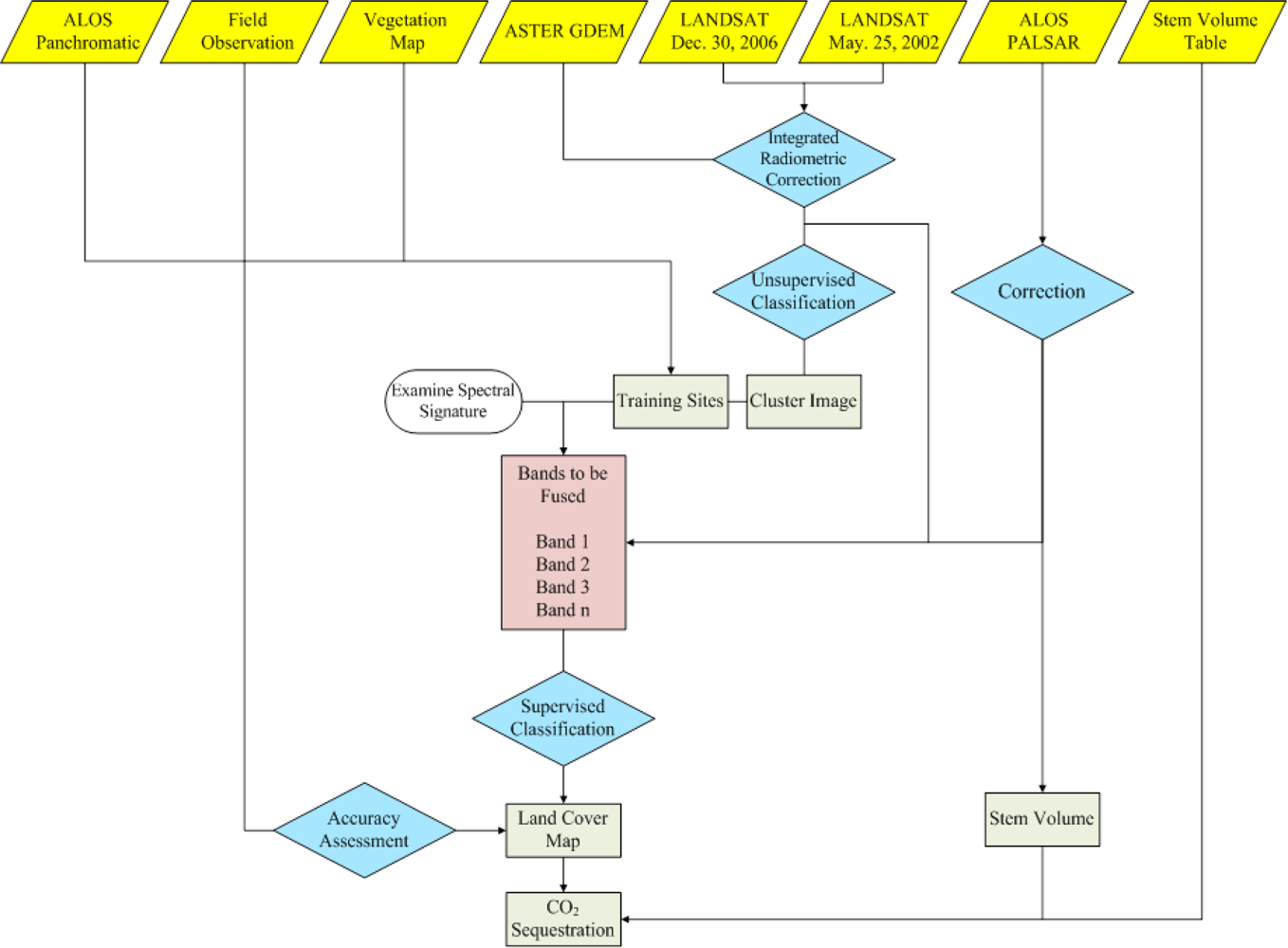
The overall flowchart of the methodology is given in
Figure 3, and consists of four main steps described hereafter. The Clark Lab’s IDRISI Taiga GIS platform [
24] was used for all the analysis.
First, unsupervised classification [
24,
25,
35] was performed to obtain a cluster image to be used for identifying the ground cover types. The IDRISI Taiga ISOCLUST module was used for the clustering process, yielding 15 distinct clusters.
Training sites were then constructed upon the cluster image and used for the supervised classification process based on the Maximum Likelihood algorithm. Data from the National Survey on the Natural Environment [
21], together with our own field investigation data, were used as ground truth references for land features identification. The strength of this method is that the need of delineating unimodal spectral classes beforehand can be overcome based upon a representative subset of image data [
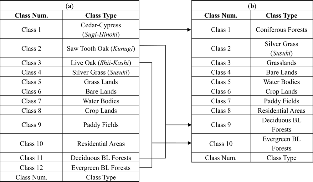
25]. The IDRISI Taiga MAXLIKE (maximum likelihood) module and the LANDSAT ETM+ 12 bands (bands 1–5 and 7 (May and December)) along with Normalized Difference Vegetation Index (NDVI) data of May and December were used in order to perform the supervised classification. This yielded a classified image with 12 categories in total. These were reclassed later on to give our final product: a classified image with 10 LU/LC categories, designed with a special attention to the forests types found over the analysis area.
In the second step, accuracy assessment was made, based on the final image. Stratified random sampling of the image yielded 29,000 sample points used for the accuracy assessment. Using the ERRMAT module of IDRISI Taiga, the error matrix was built in reference to the land features on the vegetation map from The National Survey on the Natural Environment data [
21] as ground truth.
In the third step, the information obtained from the reclassed image was used together with the CO
2 sequestration rates per unit area [
9] for the estimation of the sequestration values by each forest type. For the coniferous and deciduous broadleaf forests, we performed the estimations not only by forest type but also by breaking these forest categories down into categories per tree age in the final steps of the work.
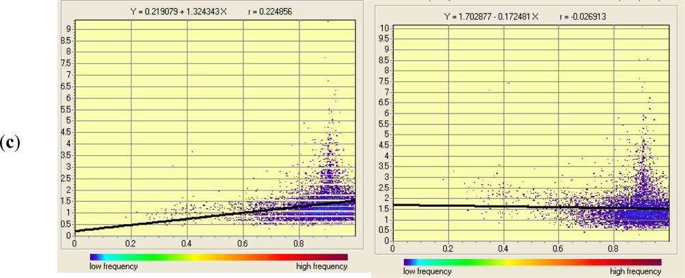
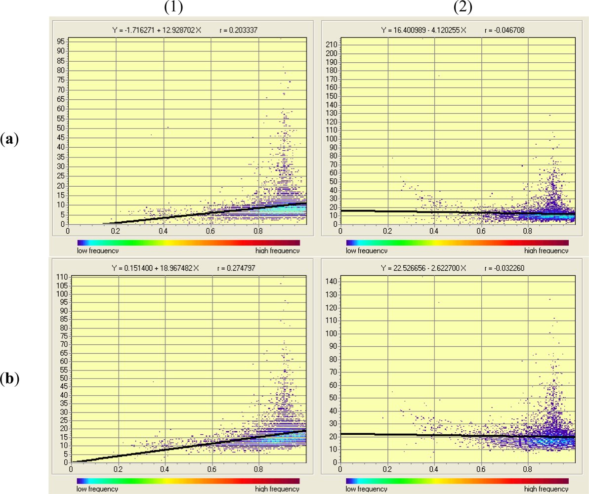
The classification of the coniferous forests per tree age was done by calculating the NDVI values using
Equation (4), where
IR stands for the infrared band (band 4) and
R for the red band (band 3). The relationship between NDVI and tree age was deduced by Ishii [
36] based on the Forest Tree Age growth curve and multitemporal NDVI data. Referring to this growth curve, we could thus classify the coniferous forests area into separate tree age categories.
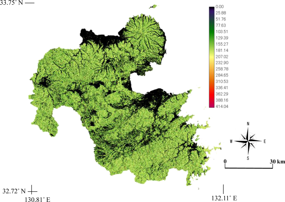
Furthermore, considering the fact that NDVI saturates with age, especially for trees older than 15 years, we attempted to improve the classification of forests area (especially coniferous and deciduous broadleaf forests) into separate tree age categories, using the backscattering intensity information derived from the PALSAR data. This was implemented for comparing the results with the tree age estimation based on the NDVI method. The relationship between backscattering intensity and stem volume, or biomass, has been analyzed by various researchers [
31,
34,
37–
42]. These various studies state that the backscattering signature correlates with the forest parameters, and that SAR images can thus be used to extract information related to the forest biomass. Because we did not collect ground data of the stem volume in our study area, we opted to use the polynomial model developed by Wijaya [
40] (
Equation (5)) to estimate the stem volume (m
3/ha).
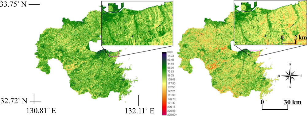
where,
V is the stem volume (m
3/ha) and
σ is the backscattering intensity. Notwithstanding the fact that this expression was developed for forests in Indonesia, we decided to apply this model because Wijaya [
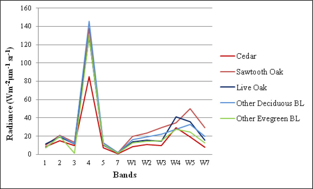
40] used it for very similar data to ours (PALSAR L-band FBD 34.3°HH/HV specifications). The stem volume map produced using this model was then classified into ages among the forests, referring to the relationship of the tree age and stem volume information provided by the Oita Prefectural Government. The classification was done for the coniferous and deciduous broadleaf forests, but not for the evergreen broadleaf forests for which no stem volume data were available. Sugi (cedar) tree data and Kunugi (saw tooth oak) tree data were used as representative for the coniferous forests and deciduous broadleaf forests, respectively.


