

Satellite Remote Sensing in Seismology. A Review

Abstract
1. Introduction
2. Deformations
2.1. Optical Sensors
2.2. InSAR
2.3. GPS
2.4. Gravity
3. Thermal Phenomena
3.1. Earth Surface
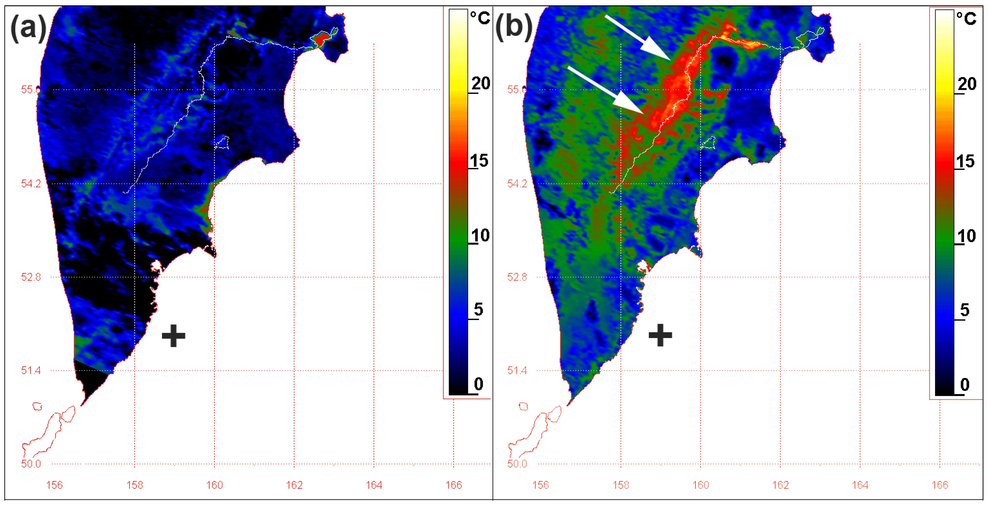
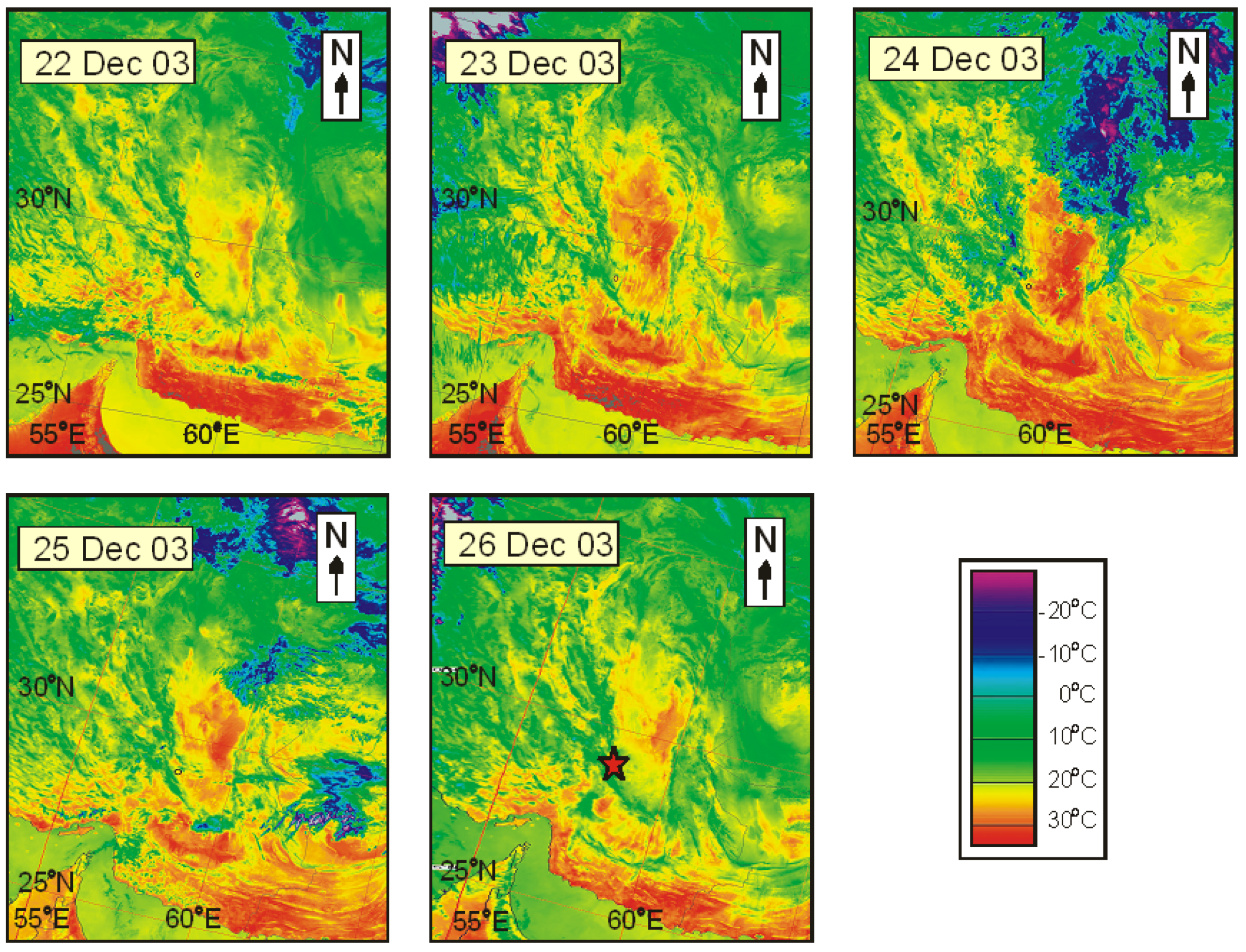
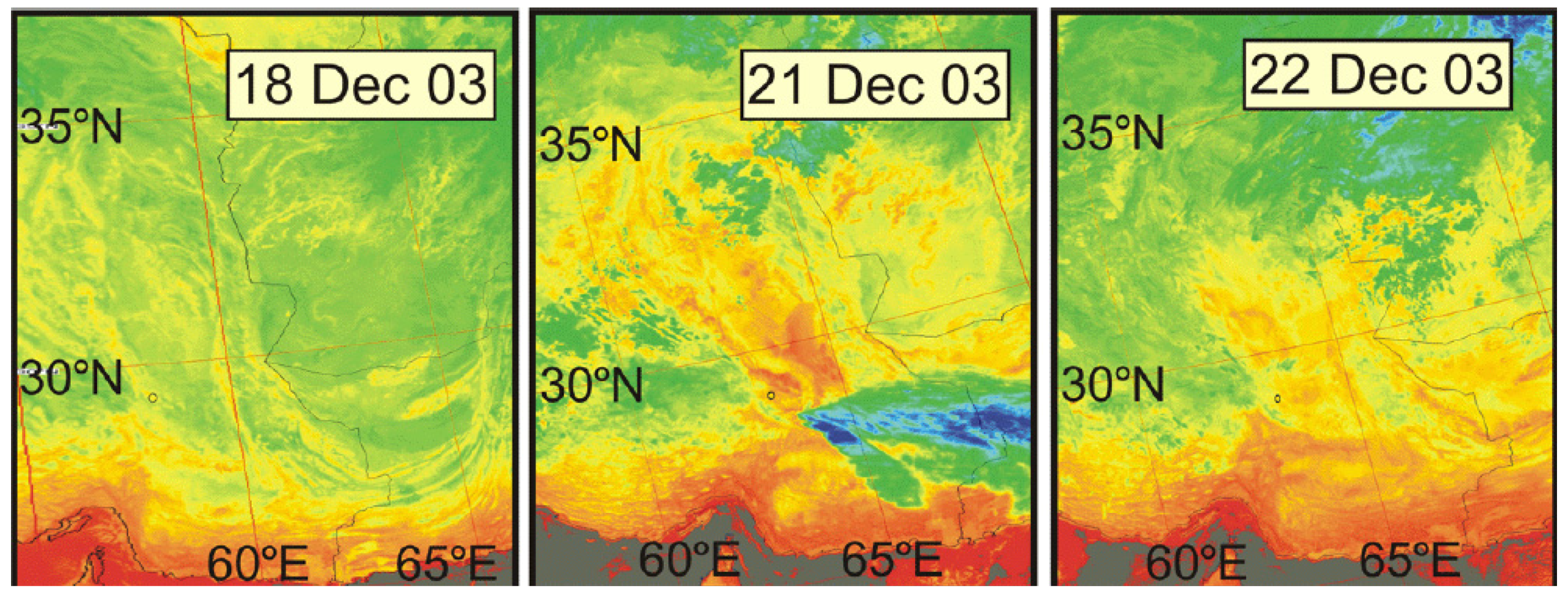
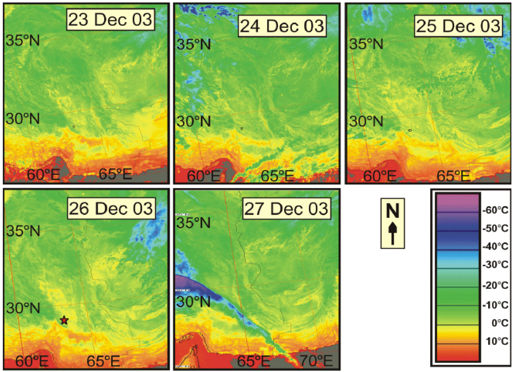
3.2. Sea Surface
3.3. Atmosphere
4. Electromagnetics
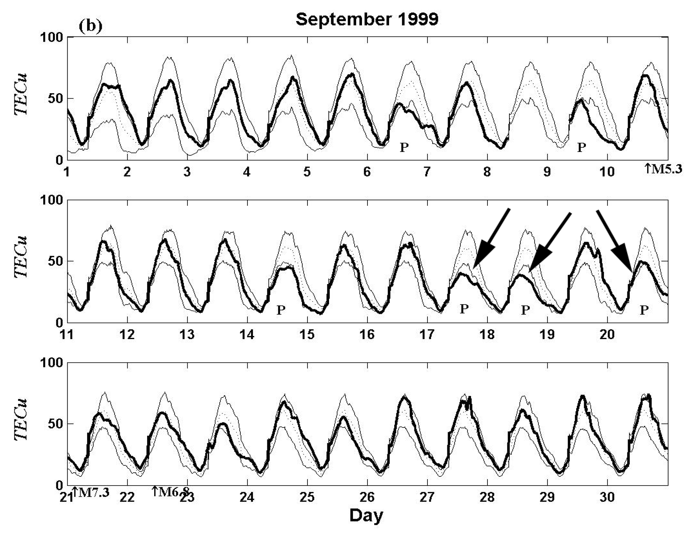
5. Discussion
6. Conclusions
References
- Showalter, P.S. Remote sensing’s use in disaster research: a review. Disaster Prevent. Manage. 2001, 10, 21–29. [Google Scholar] [CrossRef]
- Paylor, E.D., II; Evans, D.L.; Tralli, D.M. Remote sensing and geospatial information for natural hazards characterization. ISPRS J. Photogramm. Remote Sens. 2005, 59, 181–253. [Google Scholar] [CrossRef]
- IGOS. International Global Observation Strategy Geohazards Theme Report; ESA/UNESCO: European Space Agency, Paris, France, 2004; p. 54. [Google Scholar]
- Joyce, K.E.; Belliss, S.E.; Samsonov, S.V.; McNeill, S.J.; Glassey, P.J. A review of the status of satellite remote sensing and image processing techniques for mapping natural hazards and disasters. Prog. Phys. Geog. 2009, 33, 183–207. [Google Scholar] [CrossRef]
- Tronin, A.A. Remote sensing and earthquakes: a review. Phys. Chem. Earth 2006, 31, 138–142. [Google Scholar] [CrossRef]
- Hayakawa, M. Atmospheric and Ionospheric Electromagnetic Phenomena Associated with Earthquakes; Terra Sci. Pub. Co. Ltd.: Tokyo, Japan, 1999; p. 996. [Google Scholar]
- Seismo Electromagnetics: Lithosphere-Atmosphere-Ionosphere Coupling; Hayakawa, M.; Molchanov, O.A. (Eds.) Terra Science Publishing Co. Ltd.: Tokyo, Japan, 2002; p. 477.
- Clark, M.M. Finding active faults using aerial photographs. Earthqua. Inf. Bull. 1978, 10, 169–173. [Google Scholar]
- Trifonov, V.G. Active faults in Eurasia: general remarks. Tectonophysics 2004, 380, 123–130. [Google Scholar] [CrossRef]
- Trifonov, V.G.; Makarov, V.I.; Kojurin, A.I.; Skobelev, S.F.; Schulz, S.S., Jr. Aerospace Research of Seismic Zones; Nauka: Moscow, USSR, 1988; p. 133. (in Russian) [Google Scholar]
- Saraf, A.K. IRS-1C-PAN Depicts Chamoli earthquake induced landslides in Garhwal Himalayas, India. Int. J. Remote Sens. 2000, 21, 2345–2352. [Google Scholar] [CrossRef]
- Van Puymbroeck, N.; Michel, R.; Binet, R.; Avouac, J.P.; Taboury, J. Measuring earthquakes from optical satellite images. Appl. Opt. Inf. Process. 2000, 39, 1–14. [Google Scholar] [CrossRef]
- Michel, R.; Avouac, J.P. Deformation due to the 17 August Izmit, Turkey, earthquake measured from SPOT images. J. Geophys. Res. 2002. [Google Scholar] [CrossRef]
- Dominguez, S.; Avouac, J.P.; Michel, R. Horizontal coseismic deformation of the 1999 Chi-Chi earthquake measured from SPOT satellite images: Implications for the seismic cycle along the western foothills of Central Taiwan. J. Geophys. Res. 2003. [Google Scholar] [CrossRef]
- Arellano-Baeza, A.A.; Zverev, A.T.; Malinnikov, V.A. Study of changes in the lineament structure, caused by earthquakes in South America by applying the lineament analysis to the Aster (Terra) satellite data. Adv. Space Res. 2006, 37, 690–697. [Google Scholar] [CrossRef]
- Massonnet, D.; Rossi, M.; Carmona, C.; Adragna, F.; Peltzer, G.; Feigl, K.; Rabaute, T. The displacement field of the Landers earthquake mapped by radar interferometry. Nature 1993, 364, 138–142. [Google Scholar] [CrossRef]
- Peltzer, G.; Hudnut, K.; Feigl, K. Analysis of coseismic surface displacement gradients using radar interferometry: New insights into the Landers earthquake. J. Geophys. Res. 1994, 99, 21971–21981. [Google Scholar] [CrossRef]
- Tobita, M.; Fujiwara, S.; Ozawa, S.; Rosen, P.A.; Fielding, E.J.; Werner, C.L.; Murakami, M.; Nakagawa, H.; Nitta, K.; Murakami, M. Deformation of the 1995 North Sakhalin earthquake detected by JERS-1/SAR interferometry. Earth Planets Space 1998, 50, 313–325. [Google Scholar] [CrossRef]
- Schmidt, D.A.; Bürgmann, R. InSAR constraints on the source parameters of the 2001 Bhuj earthquake. Geophys. Res. Lett. 2006, 33, L02315. [Google Scholar] [CrossRef]
- Stramondo, S.; Moro, M.; Tolomei, C.; Cinti, F.R.; Doumaz, F. InSAR surface displacement field and fault modelling for the 2003 Bam earthquake (southeastern Iran). J. Geodynamics 2005, 40, 347–353. [Google Scholar] [CrossRef]
- Chini, M.; Bignami, C.; Stramondo, S.; Pierdicca, N. Uplift and subsidence due to the 26 December 2004 Indonesian earthquake detected by SAR data. Int. J. Remote Sens. 2008, 29, 3891–3910. [Google Scholar] [CrossRef]
- Kuzuoka, S.; Mizuno, T. Land Deformation Monitoring Using PSInSAR Technique. In Proceedings of International Symposium on Monitoring, Prediction and Mitigation of Disasters by Satellite Remote Sensing, Awaji, Hyogo, Japan, January 2004; pp. 176–181.
- Tsai, Y.B.; Liu, J.Y.; Ma, K.F.; Yen, H.Y.; Chen, K.S.; Chen, Y.I.; Lee, C.P. Precursory phenomena associated with the 1999 Chi-Chi earthquake in Taiwan as identified under iSTEP Program. Phys. Chem. Earth 2006, 31, 365–377. [Google Scholar] [CrossRef]
- de Michele, M.; Raucoulesa, D.; Salichon, J.; Lemoine, A.; Aochia, H. Using INSAR for seismotectonic observations over the Mw 6.3 Parkfield earthquake (28/09/2004), California. In Proceedings of Commission IV ISPRS Congress, Beijing, China, July 2008; Available online: http://www.isprs.org/congresses/beijing2008/proceedings/4_pdf/265.pdf (accessed on 15 November 2009).
- Fielding, E.J.; Lundgren, P.R.; Bürgmann, R.; Funning, G.J. Shallow fault-zone dilatancy recovery after the 2003 Bam, Iran earthquake. Nature 2009, 458, 64–68. [Google Scholar] [CrossRef] [PubMed]
- Ozawa, S.; Murakami, M.; Kaidzu, M.; Hatanaka, Y. Transient crustal deformation in Tokai region, centeral Japan, until May 2004. Earth Planets Space 2005, 57, 909–915. [Google Scholar] [CrossRef]
- Subarya, C.; Chlieh, M.; Prawirodirdjo, L.; Avouac, J.-P.; Bock, Y.; Sieh, K.; Meltzner, A.J.; Natawidjaja, D.H.; McCaffrey, R. Plate-boundary deformation associated with the great Sumatra-Andaman earthquake. Nature 2006, 440, 46–51. [Google Scholar] [CrossRef] [PubMed]
- Hashimoto, M.; Choosakul, N.; Hashizume, M.; Takemoto, S.; Takiguchi, H.; Fukuda, Y.; Fujimori, K. Crustal deformations associated with the great Sumatra-Andaman earthquake deduced from continuous GPS observation. Earth Planets Space 2006, 58, 127–139. [Google Scholar] [CrossRef]
- Han, S.-C.; Shum, C.K.; Bevis, M.; Ji, C.; Kuo, C.-Y. Crustal Dilatation Observed by GRACE after the 2004 Sumatra-Andaman Earthquake. Science 2006, 313, 658–662. [Google Scholar] [CrossRef] [PubMed]
- Gorny, V.I.; Salman, A.G.; Tronin, A.A.; Shilin, B.V. The earth’s outgoing IR radiation as an indicator of seismic activity. Proc. Acad. Sci. USSR 1988, 301, 67–69. [Google Scholar]
- Tronin, A.A. Satellite thermal survey—a new tool for the studies of seismoactive regions. Int. J. Remote Sens. 1996, 17, 1439–1455. [Google Scholar] [CrossRef]
- Quang, Z.; Xu, X.; Dian, C. Thermal infrared anomaly precursors of impending earthquakes. Chin. Sci. Bull. 1991, 36, 319–323. [Google Scholar] [CrossRef]
- Qiang, Z.; Du, L.-T. Earth degassing, forest fire and seismic activities. Earth Science Frontiers 2001, 8, 235–245. [Google Scholar]
- Tronin, A.A.; Hayakawa, M.; Molchanov, O.A. Thermal IR satellite data application for earthquake research in Japan and China. J. Geodynamics 2002, 33, 519–534. [Google Scholar] [CrossRef]
- Saraf, A.K.; Choudhury, S. Earthquakes and thermal anomalies. Geospatial Today 2003, 2, 18–20. [Google Scholar]
- Singh, R.P.; Ouzounov, D. Earth processes in wake of Gujarat earthquake reviewed from space. EOS Trans. Amer. Geophys. Union 2003, 84, 244. [Google Scholar] [CrossRef]
- Tramutoli, V.; Bello, G.D.; Pergola, N.; Piscitelli, S. Robust satellite techniques for remote sensing of seismically active areas. Ann. Geofis. 2001, 44, 295–312. [Google Scholar]
- CORDIS RTD-PROJECTS. Regular Update of Seismic Hazard Maps through Thermal Space Observations; European Communities: Madrid, Spain, Project Reference: ENV4980741; 2000. [Google Scholar]
- Ouzounov, D.; Freund, F. Mid-infrared emission prior to strong earthquakes analyzed by remote sensing data. Adv. Space Res. 2003, 33, 268–273. [Google Scholar] [CrossRef]
- Tronin, A.A.; Biagi, P.F.; Molchanov, O.A.; Khatkevich, Y.M.; Gordeeev, E.I. Temperature variations related to earthquakes from simultaneous observation at the ground stations and by satellites in Kamchatka area. Phys. Chem. Earth 2004, 29, 501–506. [Google Scholar] [CrossRef]
- Saraf, A.K.; Rawat, V.; Banerjee, P.; Choudhury, S.; Panda, S.K.; Dasgupta, S.; Das, J.D. Satellite detection of earthquake thermal precursors in Iran. Nat. Hazard 2008, 47, 119–135. [Google Scholar] [CrossRef]
- Tramutoli, V. Robust AVHRR Techniques (RAT) for environmental monitoring: theory and applications. In Earth Surface Remote Sensing II; Cecchi, G., Zilioli, E, Eds.; SPIE: Barcelona, Spain, 1998; pp. 101–113. [Google Scholar]
- Tramutoli, V.; Cuomo, V.; Filizzola, C.; Pergola, N.; Pietrapertosa, C. Assessing the potential of thermal infrared satellite surveys for monitoring seismically active areas. The case of Kocaeli (İzmit) earthquake, August 17, 1999. Remote Sens. Environ. 2005, 96, 409–426. [Google Scholar] [CrossRef]
- Ouzounov, D.; Bryant, N.; Logan, T.; Pulinets, S.; Taylor, P. Satellite thermal IR phenomena associated with some of the major earthquakes in 1999–2003. Phys. Chem. Earth 2006, 31, 154–163. [Google Scholar] [CrossRef]
- Saraf, A.K.; Choudhury, S. NOAA-AVHRR detects thermal anomaly associated with 26 January, 2001 Bhuj Earthquake, Gujarat, India. Int. J. Remote Sens. 2005, 26, 1065–1073. [Google Scholar] [CrossRef]
- Panda, S.K.; Choudhury, S.; Saraf, A.K.; Das, J.D. MODIS land surface temperature data detects thermal anomaly preceding 08 October 2005 Kashmir earthquake. Int. J. Remote Sens. 2007, 28, 4587–4596. [Google Scholar] [CrossRef]
- Wei, L.; Guo, J.; Liu, J.; Lu, Z.; Li, H.; Cai, H. Satellite thermal infrared earthquake precursor to the Wenchuan Ms 8.0 earthquake in Sichuan, China, and its analysis on geodynamics. Acta Geol. Sinica-Engl. Ed. 2009, 83, 767–775. [Google Scholar] [CrossRef]
- Pinty, B.; Gobron, N.; Verstraete, M.M.; Mélin, F.; Widlowski, J.-L.; Govaerts, Y.; Diner, D.J.; Fielding, E.; Nelson, D.L.; Madariaga, R.; Tuttle, M.P. Observing earthquake-related dewatering using MISR/Terra satellite Data. EOS Trans. Amer. Geophys. Union 2003, 84, 37–48. [Google Scholar] [CrossRef]
- Dey, S.; Singh, R.P. Surface latent heat flux as an earthquake precursor. Nat. Hazards Earth Syst. 2003, 3, 749–755. [Google Scholar] [CrossRef]
- Pulinets, S.A.; Ouzounov, D.; Ciraolo, L.; Singh, R.; Cervone, G.; Leyva, A.; Dunajecka, M.; Karelin, A.V.; Boyarchuk, K.A.; Kotsarenko, A. Thermal, atmospheric and ionospheric anomalies around the time of the Colima M7.8 earthquake of 21 January 2003. Ann. Geophys. 2006, 24, 835–849. [Google Scholar] [CrossRef]
- Cervone, G.; Maekawa, S.; Singh, R.; Hayakawa, M.; Kafatos, M.; Shavets, A. Surface latent heat flux and nighttime LF anomalies prior to the Mw = 8.3 Tokachi-Oki earthquake. Nat. Hazards Earth Syst. Sci. 2006, 6, 109–114. [Google Scholar] [CrossRef]
- Ma, W.; Ma, W.; Zhao, H.; Li, H. Temperature changing process of the Hokkaido (Japan) earthquake on 25 September 2003. Nat. Hazards Earth Syst. Sci. 2008, 8, 985–989. [Google Scholar] [CrossRef]
- Ouzounov, D.; Freund, F. Mid-infrared emission prior to strong earthquakes analyzed by remote sensing data. Adv. Space Res. 2004, 33, 268–273. [Google Scholar] [CrossRef]
- Singh, R.P.; Bhoi, S.; Sahoo, A.K. Changes observed on land and ocean after Gujarat earthquake of January 26, 2001 using IRS data. Int. J. Remote Sens. 2002, 23, 3123–3128. [Google Scholar] [CrossRef]
- Singh, R.P.; Cervone, G.; Kafatos, M.; Prasad, A.K.; Sahoo, A.K.; Sun, D.; Tang, D.L.; Yang, R. Multi-sensor studies of the Sumatra earthquake and tsunami of 26 December 2004. Int. J. Remote Sens. 2007, 28, 2885–2896. [Google Scholar] [CrossRef]
- Ouzounov, D.; Liu, D.; Kang, C.; Cervone, G.; Kafatos, M.; Taylor, P. Outgoing long wave radiation variability from IR satellite data prior to major earthquakes. Tectonophysics 2007, 431, 211–220. [Google Scholar] [CrossRef]
- Dey, S.; Sarkar, S.; Singh, R.P. Anomalous changes in column water vapor after Gujarat earthquake. Adv. Space Res. 2004, 33, 274–278. [Google Scholar] [CrossRef]
- Okada, Y.; Mukai, S.; Singh, R.P. Changes in atmospheric aerosol parameters after Gujarat earthquake of January 26, 2001. Adv. Space Res. 2004, 33, 254–258. [Google Scholar] [CrossRef]
- Tronin, A.A. Atmosphere-litosphere coupling. Thermal anomalies on the earth surface in seismic processes. In Seismo Electromagnetics: Lithosphere-Atmosphere-Ionosphere Coupling; Hayakawa, M., Molchanov, O.A., Eds.; TERRAPUB: Tokyo, Japan, 2002; pp. 173–176. [Google Scholar]
- Morozova, L.I. Features of atmo-lithmospheric relationships during periods of strong Asian earthquakes. Izvestiya, Phys. Solid Earth 1996, 5, 63–68. [Google Scholar]
- Guo, G.; Wang, B. Cloud anomaly before Iran earthquake. Int. J. Remote Sens. 2008, 29, 1921–1928. [Google Scholar] [CrossRef]
- Gup, G.; Xie, G. Earthquake cloud over Japan detected by satellite. Int. J. Remote Sens. 2007, 28, 5375–5376. [Google Scholar] [CrossRef]
- Uyeda, S.; Nagao, T.; Kamogawa, M. Short-term earthquake prediction: current status of seismo-electromagnetics. Tectonophysics 2009, 470, 205–213. [Google Scholar] [CrossRef]
- Parrot, M. The micro-satelitte DEMETER. J. Geodynamics 2002, 33, 535–541. [Google Scholar] [CrossRef]
- Molchanov, O.; Rozhnoi, A.; Solovieva, M.; Akentieva, O.; Berthelier, J.J.; Parrot, M.; Lefeuvre, F.; Biagi, P.F.; Castellana, L.; Hayakawa, M. Global diagnostics of the ionospheric perturbations related to the seismic activity using the VLF radio signals collected on the DEMETER satellite. Nat. Hazards Earth Syst. Sci. 2006, 6, 745–753. [Google Scholar] [CrossRef]
- Parrot, M.; Berthelier, J.J.; Lebreton, J.P.; Sauvaud, J.A.; Santolík, O.; Blecki, J. Examples of unusual ionospheric observations made by the DEMETER satellite over seismic regions. Phys. Chem. Earth 2006, 31, 486–495. [Google Scholar] [CrossRef]
- Liu, J.; Chuo, Y.; Shan, S.; Tsai, Y.; Chen, Y.; Pulinets, S.; Yu, S. Pre-earthquake ionospheric anomalies registered by continuous GPS TEC measurements. Ann. Geophys. 2004, 22, 1585–1593. [Google Scholar] [CrossRef]
- Liu, J.Y.; Tsai, Y.B.; Chen, S.W.; Lee, C.P.; Chen, Y.C.; Yen, H.Y.; Chang, W.Y.; Liu, C. Giant ionospheric disturbances excited by the M9.3 Sumatra earthquake of 26 December 2004. Geophys. Res. Lett. 2006, 33, L02103. [Google Scholar] [CrossRef]
- Liu, J.-Y.; Tsai, Y.-B.; Ma, K.-F.; Chen, Y.-I.; Tsai, H.-F.; Lin, C.-H.; Kamogawa, M.; Lee, C.-P. Ionospheric GPS total electron content (TEC) disturbances triggered by the 26 December 2004 Indian Ocean tsunami. J. Geophys. Res. 2006, 111, A05303. [Google Scholar] [CrossRef]
- Liu, J.Y.; Chen, Y.I.; Chen, C.H.; Liu, C.Y.; Chen, C.Y.; Nishihashi, M.; Li, J.Z.; Xia, Y.Q.; Oyama, K.I.; Hattori, K.; Lin, C.H. Seismoionospheric GPS total electron content anomalies observed before the 12 May 2008 Mw7.9 Wenchuan earthquake. J. Geophys. Res. 2009, 114, A04320. [Google Scholar]
© 2010 by the authors; licensee Molecular Diversity Preservation International, Basel, Switzerland. This article is an open-access article distributed under the terms and conditions of the Creative Commons Attribution license (http://creativecommons.org/licenses/by/3.0/).
Share and Cite
Tronin, A.A. Satellite Remote Sensing in Seismology. A Review. Remote Sens. 2010, 2, 124-150. https://doi.org/10.3390/rs2010124
Tronin AA. Satellite Remote Sensing in Seismology. A Review. Remote Sensing. 2010; 2(1):124-150. https://doi.org/10.3390/rs2010124
Chicago/Turabian StyleTronin, Andrew A. 2010. "Satellite Remote Sensing in Seismology. A Review" Remote Sensing 2, no. 1: 124-150. https://doi.org/10.3390/rs2010124
APA StyleTronin, A. A. (2010). Satellite Remote Sensing in Seismology. A Review. Remote Sensing, 2(1), 124-150. https://doi.org/10.3390/rs2010124

