Improving Satellite-Based Estimation and Mapping of Soil Lead by Using an Enhanced Spectral Feature Set and XGBoost Model
 ,
, 

Highlights
- An enhanced spectral feature set (ESFS) was constructed, and two new spectral indices for Pb-contaminated soils, named SPPI-2 and SPPI-3, were developed and incorporated into the ESFS.
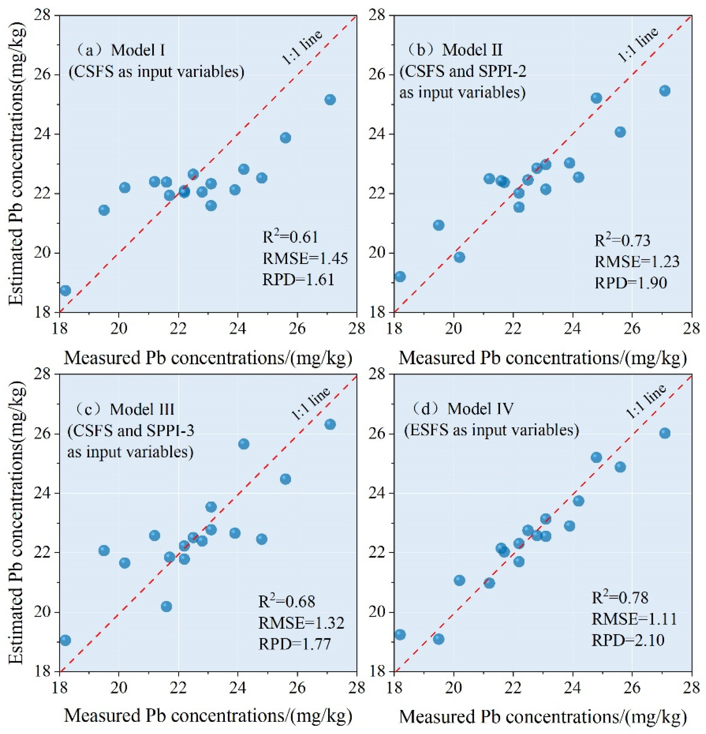
- The XGBoost-based satellite hyperspectral mapping model achieved satisfactory performance (RPD = 2.06).
- This study presents new spectral indices for effectively characterizing Pb-contaminated soils and supporting regional-scale soil management.
- This study provides a solution framework for estimating and mapping soil heavy metals, which assists in contamination hotspot identification and promotes environmental sustainability.
Abstract
1. Introduction
2. Materials and Methods
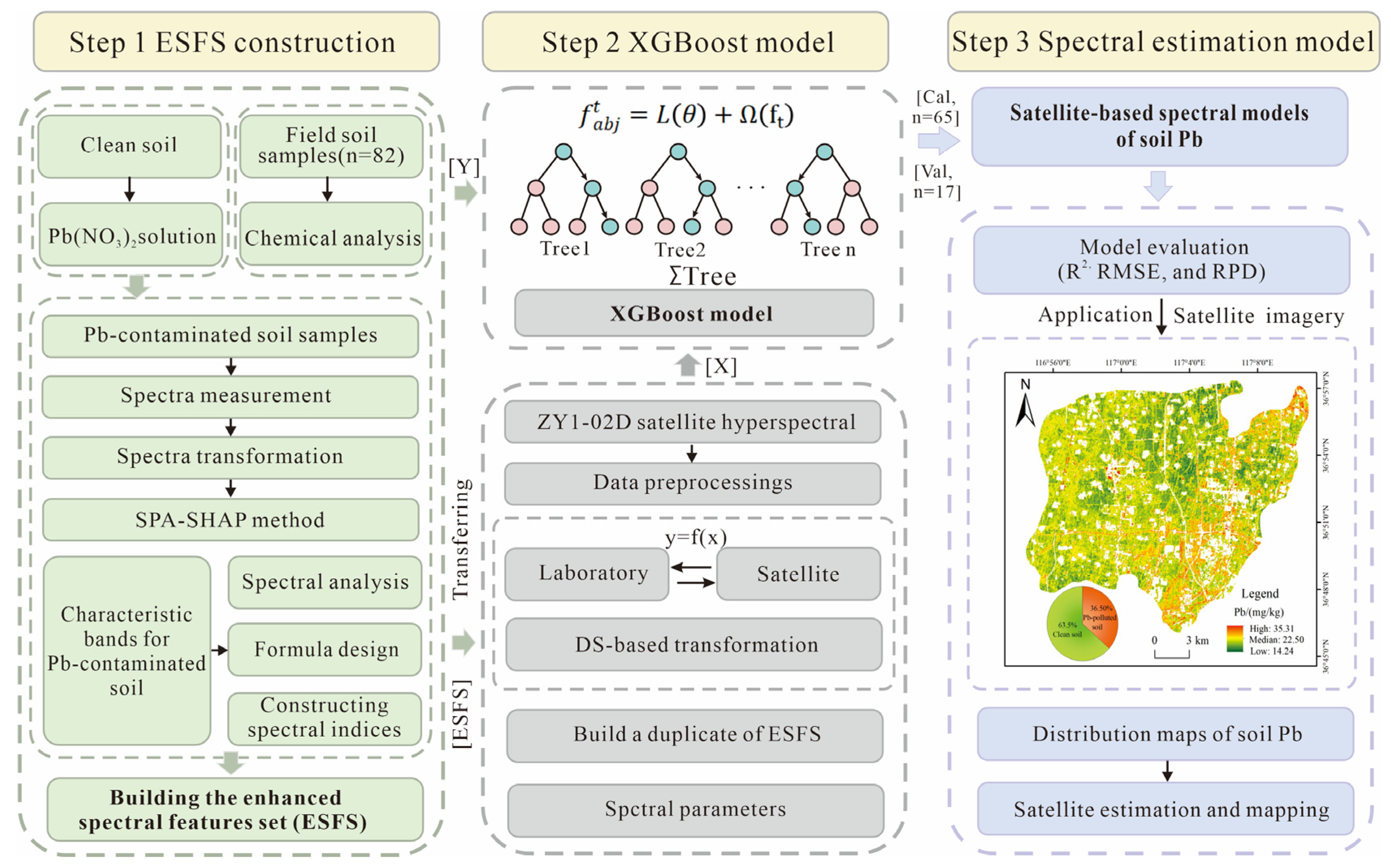
2.1. Flowchart for Building the Satellite-Based Spectral Estimation Model of Soil Pb
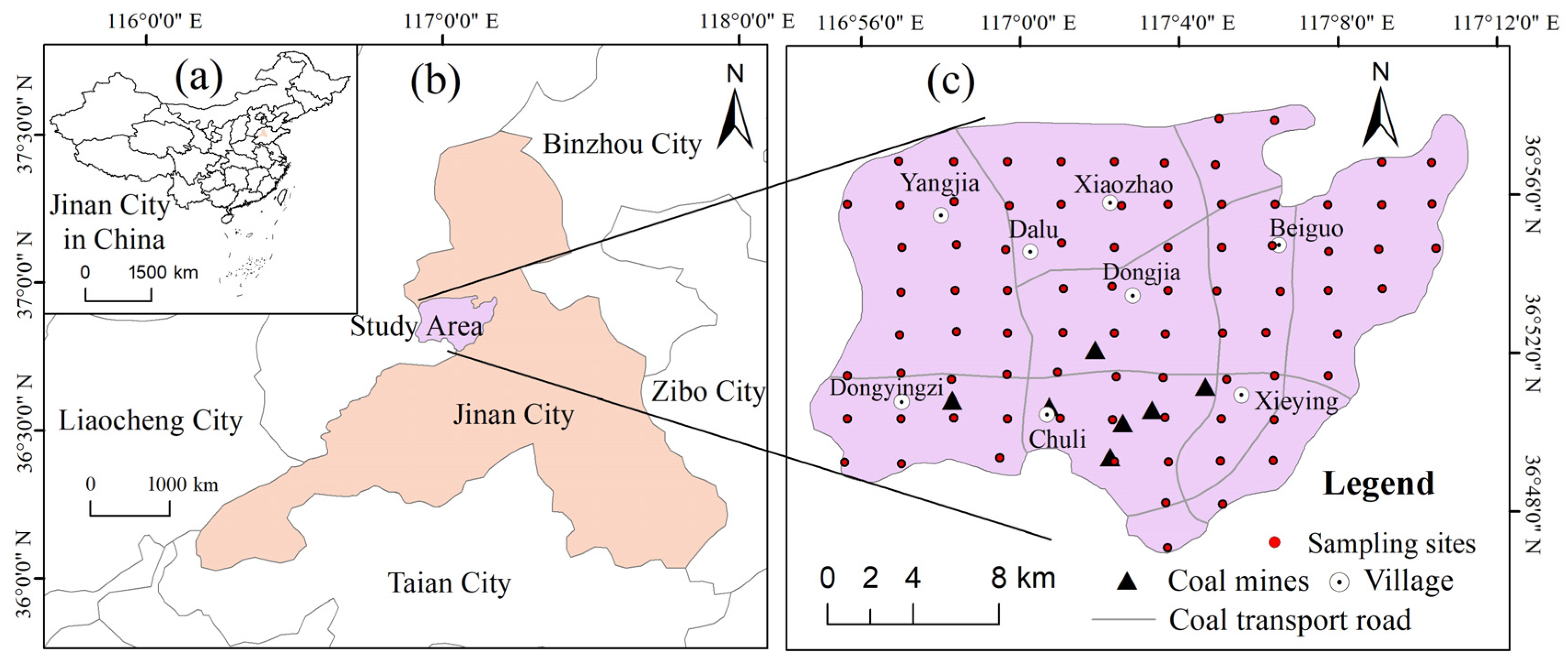
2.2. Study Area and Field Soil Sampling
- (1)
- Study area
- (2)
- Field soil sampling and chemical analysis
2.3. Hyperspectral Imagery Acquisition and Preprocessing
2.3.1. Satellite Hyperspectral Imagery Acquisition
2.3.2. Extracting the Bare Soil Areas from the Hyperspectral Imagery
2.4. Building the Enhanced Spectral Features Set (ESFS)
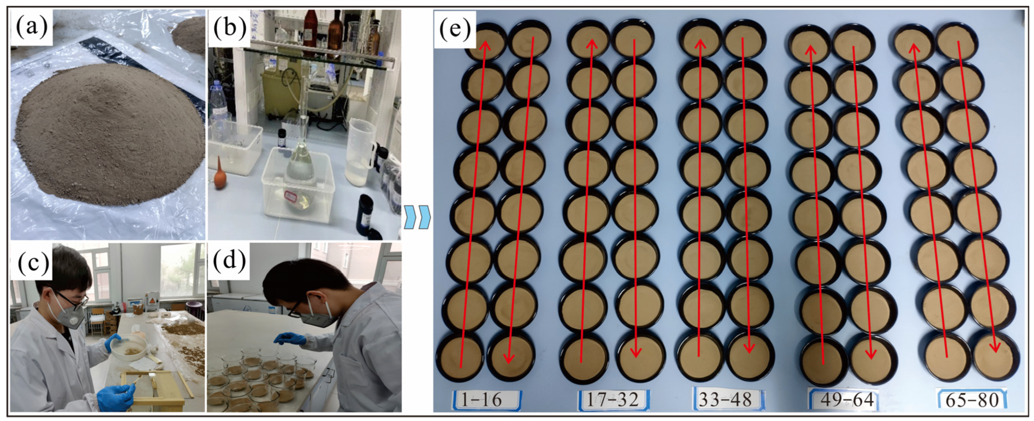
2.4.1. Laboratory Preparation of Pb-Contaminated Soil Samples
- (1)
- Preparation of the Pb-contaminated soil samples
- (2)
- Statistical characteristics of soil Pb concentrations in laboratory-prepared soil samples
2.4.2. Spectral Measurement
- (1)
- Imaging spectral measurement
- (2)
- Spectral pretreatment
2.4.3. Spectral Transformation
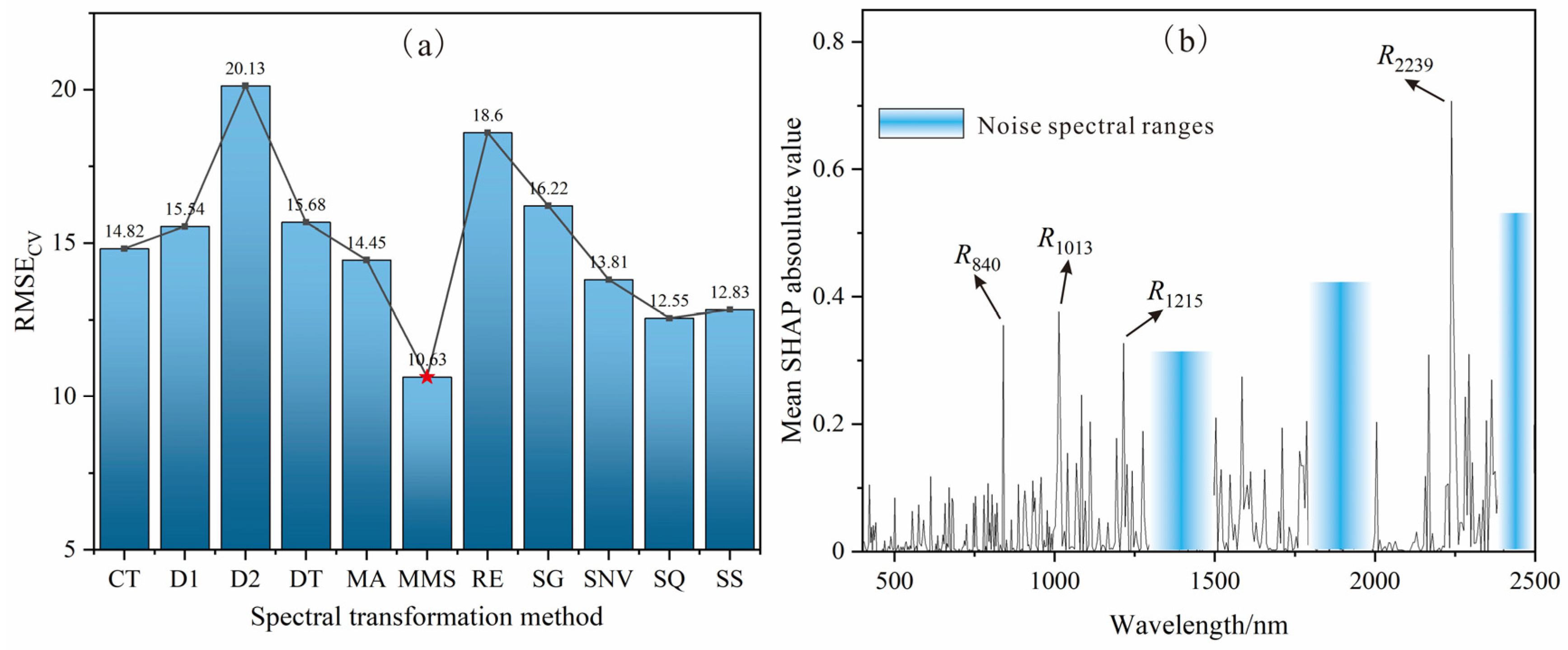
2.4.4. Characteristic Bands Selection
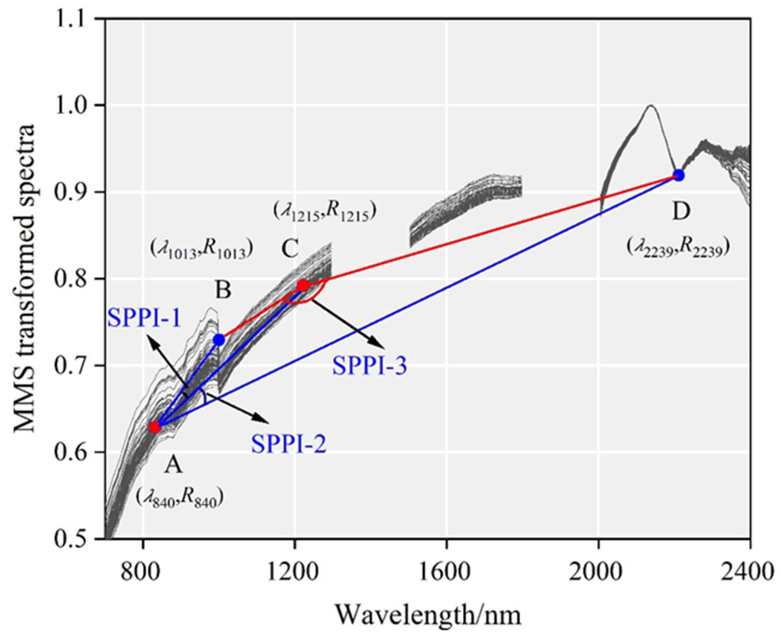
2.4.5. SPPI Construction
- (1)
- Key parameters and formulas
- (2)
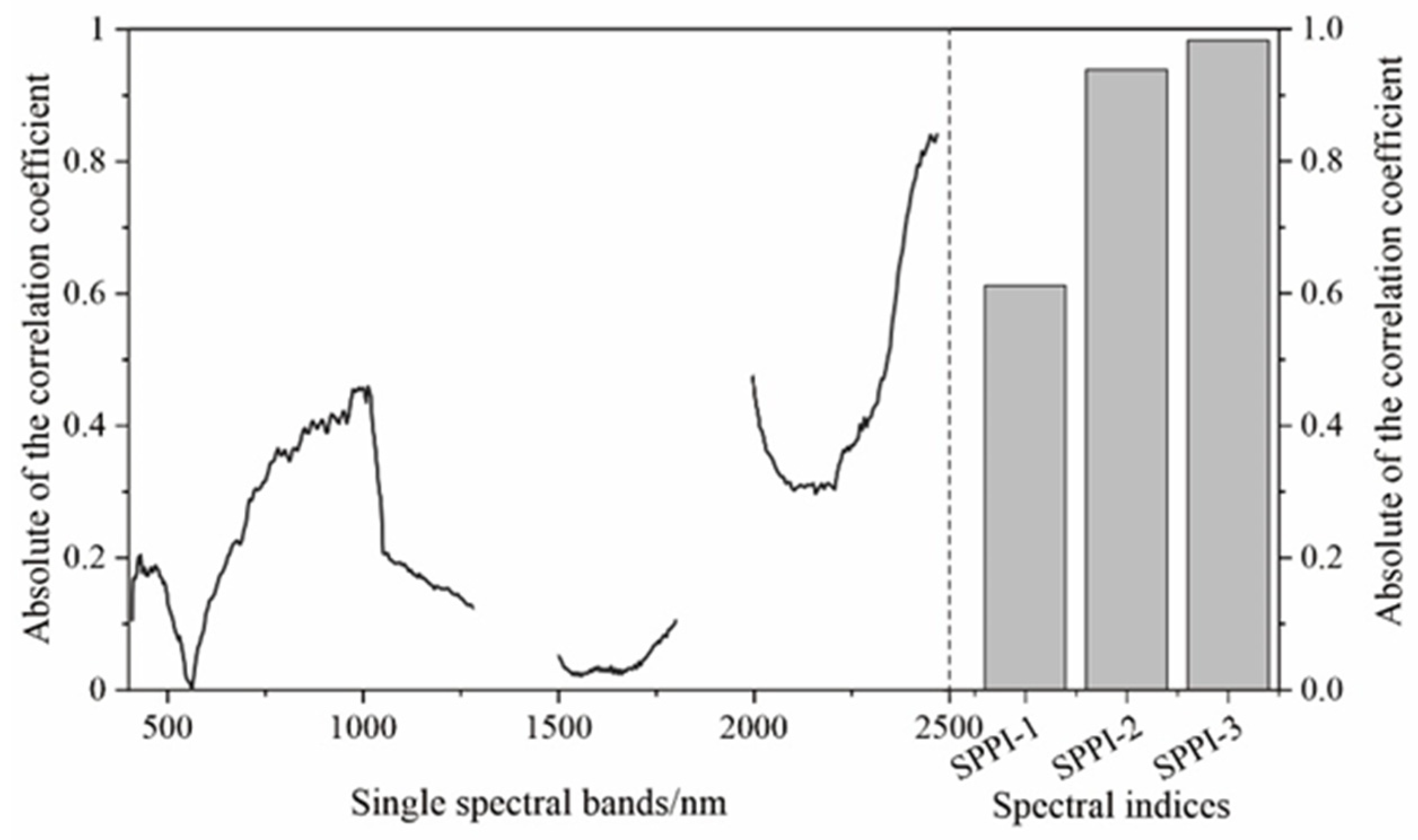
- Optimal SPPIs
2.5. Transferring the ESFS from Laboratory to Satellite
2.6. XGBoost Algorithm
2.7. Model Calibration and Evaluation
3. Results and Analysis
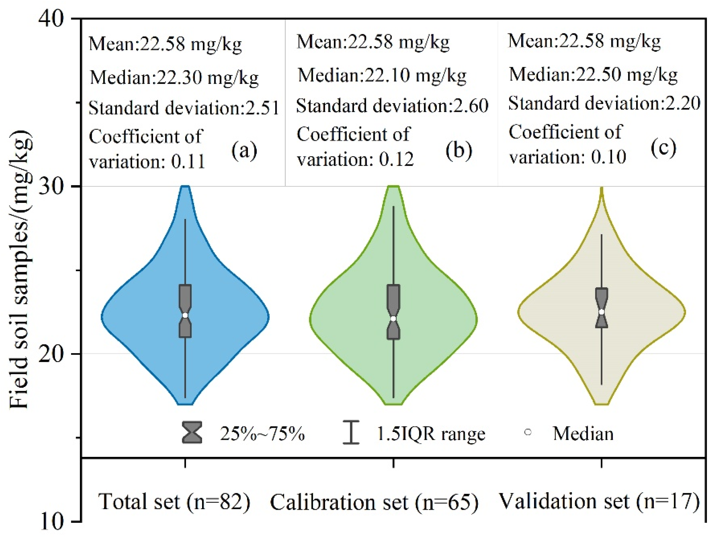
3.1. Descriptive Statistical Characteristics of Pb Concentrations in Field Soil Samples
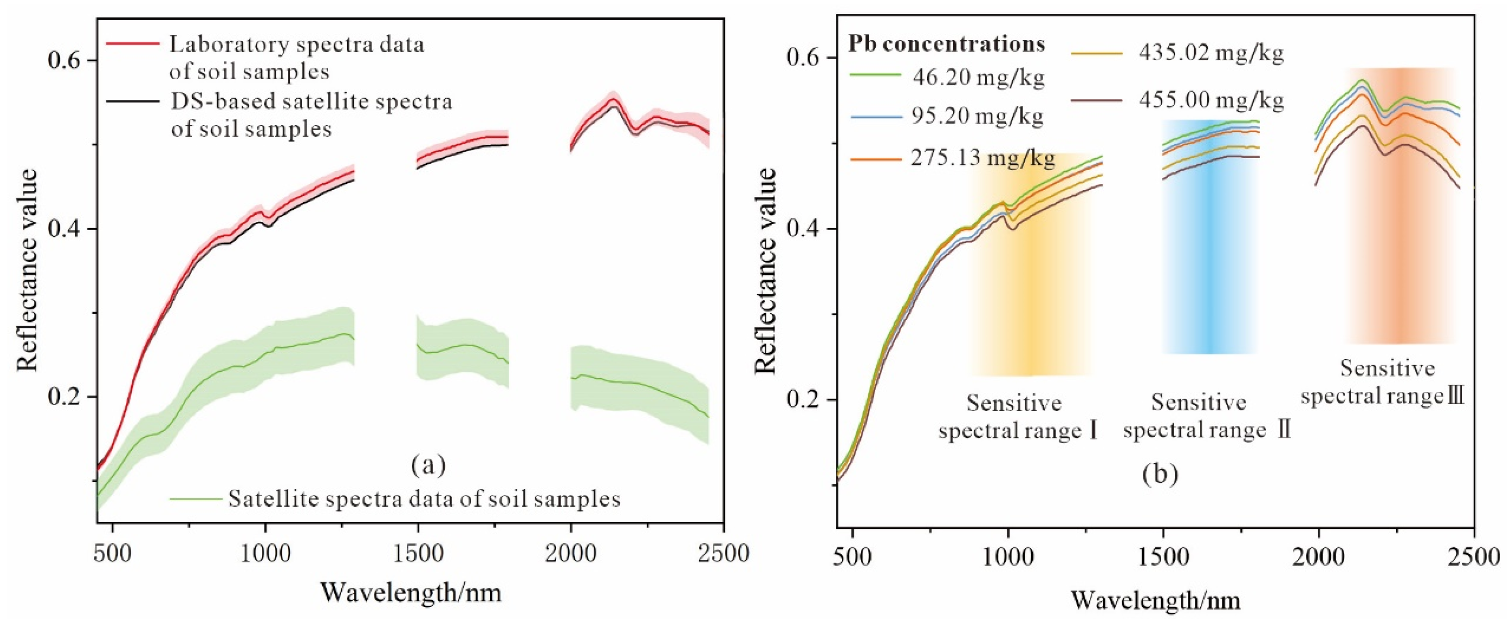
3.2. Spectral Characteristics of Laboratory, Satellite, and DS-Transformed Satellite Spectra
3.3. Comparison of Satellite-Based Spectral Estimation Models for Soil Pb
3.4. Soil Pb Maps
3.5. Uncertainty in the Soil Pb Mapping
4. Discussion
5. Conclusions
Supplementary Materials
Author Contributions
Funding
Data Availability Statement
Acknowledgments
Conflicts of Interest
References
- Zhang, M.; Wang, J.; Li, S. Tempo-spatial changes and main anthropogenic influence factors of vegetation fractional coverage in a large-scale opencast coal mine area from 1992 to 2015. J. Clean. Prod. 2019, 232, 940–952. [Google Scholar] [CrossRef]
- Zerizghi, T.; Guo, Q.; Tian, L.; Wei, R.; Zhao, C. An integrated approach to quantify ecological and human health risks of soil heavy metal contamination around coal mining area. Sci. Total Environ. 2022, 814, 152653. [Google Scholar] [CrossRef]
- Liu, X.; Bai, Z.; Shi, H.; Zhou, W.; Liu, X. Heavy metal pollution of soils from coal mines in China. Nat. Hazards 2019, 99, 1163–1177. [Google Scholar] [CrossRef]
- Islam, A.; Jion, M.; Jannat, J.; Varol, M.; Islam, M.; Khan, R.; Idris, A.; Malafaia, G.; Habib, M. Perception and legacy of soil chromium and lead contamination in an operational small-scale coal mining community. Environ. Geochem. Health 2023, 45, 7237–7253. [Google Scholar] [CrossRef] [PubMed]
- Zhu, L.; Zhang, L.; Wang, J.; Lv, J. Combining finite mixture distribution, receptor model, and geostatistical simulation to evaluate heavy metals pollution in soils: Source and spatial pattern. Land Degrad. Dev. 2021, 32, 2105–2115. [Google Scholar] [CrossRef]
- Parzentny, H.R.; Róg, L. Distribution and mode of occurrence of Co, Ni, Cu, Zn, As, Ag, Cd, Sb, Pb in the feed coal, fly ash, slag, in the topsoil and in the roots of trees and undergrowth downwind of three power stations in Poland. Minerals 2021, 11, 133. [Google Scholar] [CrossRef]
- Li, J.; Xu, X.; Lv, J.; Wu, Q.; Ren, M.; Cao, J.; Liu, P. Source apportionment and health risk quantification for heavy metal sources in soils near aluminum-plastic manufacturing facilities in northeast China. Hum. Ecol. Risk Assess. 2020, 26, 2225–2244. [Google Scholar] [CrossRef]
- Collin, M.S.; Venkatraman, S.K.; Vijayakumar, N.; Kanimozhi, V.; Arbaaz, S.M.; Stacey, R.S.; Anusha, J.; Choudhary, R.; Lvov, V.; Tovar, G.I. Bioaccumulation of lead (Pb) and its effects on human: A review. J. Hazard. Mater. Adv. 2022, 7, 100094. [Google Scholar] [CrossRef]
- Wang, Y.; Zou, B.; Chai, L.; Lin, Z.; Feng, H.; Tang, Y.; Tian, R.; Tu, Y.; Zhang, B.; Zou, H. Monitoring of soil heavy metals based on hyperspectral remote sensing: A review. Earth-Sci. Rev. 2024, 254, 104814. [Google Scholar] [CrossRef]
- Mirzaei, M.; Verrelst, J.; Marofi, S.; Abbasi, M.; Azadi, H. Eco-friendly estimation of heavy metal contents in grapevine foliage using in-field hyperspectral data and multivariate analysis. Remote Sens. 2019, 11, 2731. [Google Scholar] [CrossRef]
- Tan, K.; Ma, W.; Chen, L.; Wang, H.; Du, Q.; Du, P.; Yan, B.; Liu, R.; Li, H. Estimating the distribution trend of soil heavy metals in mining area from HyMap airborne hyperspectral imagery based on ensemble learning. J. Hazard. Mater. 2021, 401, 123288. [Google Scholar] [CrossRef] [PubMed]
- Wang, Z.; Chen, X.; Yu, D.; Zhang, L.; Wang, J.; Lv, J. Source apportionment and spatial distribution of potentially toxic elements in soils: A new exploration on receptor and geostatistical models. Sci. Total Environ. 2021, 759, 143428. [Google Scholar] [CrossRef]
- Reza, S.; Baruah, U.; Singh, S.; Das, T. Geostatistical and multivariate analysis of soil heavy metal contamination near coal mining area, Northeastern India. Environ. Earth Sci. 2015, 73, 5425–5433. [Google Scholar] [CrossRef]
- Zhou, M.; Zou, B.; Tu, Y.; Feng, H.; He, C.; Ma, X.; Ning, J. Spectral response feature bands extracted from near standard soil samples for estimating soil Pb in a mining area. Geocarto Int. 2022, 37, 13248–13267. [Google Scholar] [CrossRef]
- Mzid, N.; Castaldi, F.; Tolomio, M.; Pascucci, S.; Casa, R.; Pignatti, S. Evaluation of agricultural bare soil properties retrieval from Landsat 8, Sentinel-2 and PRISMA satellite data. Remote Sens. 2022, 14, 714. [Google Scholar] [CrossRef]
- Canero, F.M.; Rodriguez-Galiano, V.; Chabrillat, S. Evaluating Airborne Hyperspectral Scanner (AHS) for the mapping of soil organic matter and clay in a Mediterranean forest ecosystem. Catena 2025, 252, 108889. [Google Scholar] [CrossRef]
- Zhang, J.; Ding, J.; Tan, J.; Wang, J.; Zhang, Z.; Wang, Z.; Ge, X. Monitoring soil salinization in arid cotton fields using unmanned aerial vehicle hyperspectral imagery. Int. J. Appl. Earth Obs. Geoinf. 2025, 140, 104584. [Google Scholar] [CrossRef]
- Ma, X.; Wang, J.; Zhou, K.; Zhang, W.; Chen, A. Uncertainty in soil elemental prediction using machine learning and hyperspectral remote sensing. J. Hazard. Mater. 2025, 494, 138502. [Google Scholar] [CrossRef] [PubMed]
- Shen, Q.; Shang, K.; Xiao, C.; Tang, H.; Wu, T.; Wang, C. A novel hyperspectral remote sensing estimation model for surface soil texture using AHSI/ZY1-02D satellite image. Int. J. Appl. Earth Obs. Geoinf. 2025, 138, 104453. [Google Scholar] [CrossRef]
- Xu, X.; Ren, M.; Cao, J.; Wu, Q.; Liu, P.; Lv, J. Spectroscopic diagnosis of zinc contaminated soils based on competitive adaptive reweighted sampling algorithm and an improved support vector machine. Spectrosc. Lett. 2019, 53, 86–99. [Google Scholar] [CrossRef]
- Liu, Z.; Lu, Y.; Peng, Y.; Zhao, L.; Wang, G.; Hu, Y. Estimation of soil heavy metal content using hyperspectral data. Remote Sens. 2019, 11, 1464. [Google Scholar] [CrossRef]
- Chen, L.; Lai, J.; Tan, K.; Wang, X.; Chen, Y.; Ding, J. Development of a soil heavy metal estimation method based on a spectral index: Combining fractional-order derivative pretreatment and the absorption mechanism. Sci. Total Environ. 2022, 813, 151882. [Google Scholar] [CrossRef]
- Rossel, R.V.; Behrens, T. Using data mining to model and interpret soil diffuse reflectance spectra. Geoderma 2010, 158, 46–54. [Google Scholar] [CrossRef]
- Sun, W.; Liu, S.; Zhang, X.; Zhu, H. Performance of hyperspectral data in predicting and mapping zinc concentration in soil. Sci. Total Environ. 2022, 824, 153766. [Google Scholar] [CrossRef] [PubMed]
- Nawar, S.; Cipullo, S.; Douglas, R.; Coulon, F.; Mouazen, A. The applicability of spectroscopy methods for estimating potentially toxic elements in soils: State-of-the-art and future trends. Appl. Spectrosc. Rev. 2020, 55, 525–557. [Google Scholar] [CrossRef]
- Lei, H.; Bao, N.; Yu, M.; Cao, Y. Estimating and mapping tailings properties of the largest iron cluster in China for resource potential and reuse: A new perspective from interpretable CNN model and proposed spectral index based on hyperspectral satellite imagery. Int. J. Appl. Earth Obs. Geoinf. 2025, 139, 104512. [Google Scholar] [CrossRef]
- Prakash, A.; Thangaraj, J.; Roy, S.; Srivastav, S.; Mishra, J.K. Model-aware XGBoost method towards optimum performance of flexible distributed Raman amplifier. IEEE Photonics J. 2023, 15, 1–10. [Google Scholar] [CrossRef]
- Xu, X.; Wang, X.; Yang, P.; Meng, Y.; Yu, D.; Li, C. Strategy for mapping soil salt contents during the bare soil period through a satellite image: Optimal calibration set combined with random forest. Catena 2023, 223, 106900. [Google Scholar] [CrossRef]
- Dharumarajan, S.; Lalitha, M.; Kalaiselvi, B.; Kaliraj, S.; Adhikari, K.; Vasundhara, R.; Niranjana, K.; Hegde, R.; Pradeep, C.; Hittanagi, P. Remote sensing of soils: Spectral signatures and spectral indices. In Remote Sensing of Soils; Elsevier: Amsterdam, The Netherlands, 2024; pp. 13–23. [Google Scholar]
- Wang, J.; Ding, J.; Yu, D.; Ma, X.; Zhang, Z.; Ge, X.; Teng, D.; Li, X.; Liang, J.; Lizaga, I.; et al. Capability of Sentinel-2 MSI data for monitoring and mapping of soil salinity in dry and wet seasons in the Ebinur Lake region, Xinjiang, China. Geoderma 2019, 353, 172–187. [Google Scholar] [CrossRef]
- Zhang, Z.; Ding, J.; Wang, J.; Ge, X. Prediction of soil organic matter in northwestern China using fractional-order derivative spectroscopy and modified normalized difference indices. Catena 2020, 185, 104257. [Google Scholar] [CrossRef]
- dos Santos, E.P.; Moreira, M.C.; Fernandes-Filho, E.I.; Demattê, J.A.; dos Santos, U.J.; Moura-Bueno, J.M.; Cruz, R.R.P.; da Silva, D.D.; Sampaio, E.V.d.S.B. Integrating satellite radar vegetation indices and environmental descriptors with visible-infrared soil spectroscopy improved organic carbon prediction in soils of semi-arid Brazil. Geoderma 2025, 457, 117288. [Google Scholar] [CrossRef]
- Wang, S.; Zhou, Y.; You, X.; Wang, B.; Du, L. Quantification of the antagonistic and synergistic effects of Pb2+, Cu2+, and Zn2+ bioaccumulation by living Bacillus subtilis biomass using XGBoost and SHAP. J. Hazard. Mater. 2023, 446, 130635. [Google Scholar] [CrossRef]
- Chen, T.; He, T.; Benesty, M.; Khotilovich, V.; Tang, Y.; Cho, H.; Chen, K.; Mitchell, R.; Cano, I.; Zhou, T. R Package, version 0.4-2. XGBoost: Extreme Gradient Boosting. CRAN (Comprehensive R Archive Network): Vienna, Austria, 2015.
- Sun, M.; Liu, H.; Li, P.; Gong, P.; Yu, X.; Ye, F.; Guo, Y.; Wu, Z. Effects of salt content and particle size on spectral reflectance and model accuracy: Estimating soil salt content in arid, saline-alkali lands. Microchem. J. 2024, 207, 111666. [Google Scholar] [CrossRef]
- Luo, Y.; Li, C.; Huang, J.; Dong, C.; Wang, J. Integrating fractional-order derivatives of soil and leaf hyperspectral reflectance for improved estimation of mangrove soil organic carbon. Geoderma 2025, 458, 117324. [Google Scholar] [CrossRef]
- Liang, H.; Song, Y.; Dai, Z.; Liu, H.; Zhong, K.; Feng, H.; Xu, L. Soil total nitrogen content and pH value estimation method considering spatial heterogeneity: Based on GNNW-XGBoost model. Spectrochim. Acta A Mol. Biomol. Spectrosc. 2025, 330, 125716. [Google Scholar] [PubMed]
- Ye, M.; Zhu, L.; Li, X.; Ke, Y.; Huang, Y.; Chen, B.; Yu, H.; Li, H.; Feng, H. Estimation of the soil arsenic concentration using a geographically weighted XGBoost model based on hyperspectral data. Sci. Total Environ. 2023, 858, 159798. [Google Scholar]
- Sui, J.; Hao, Q. Evaluation of geological environmental carrying capacity in the Huanghebei coal mining area, Shandong Province. Shandong Land Resour. 2017, 33, 34–40. [Google Scholar]
- Zhang, B.; Yang, K.; Zhang, K.; Wang, Q.; Wu, N. Migration transformation, prevention, and control of typical heavy metal lead in coal gangue: A review. Int. J. Coal Sci. Technol. 2023, 10, 85. [Google Scholar] [CrossRef]
- Wang, W.; Xu, X.; Zhou, Z.; Dong, X.; Tian, T. A joint method to assess pollution status and source-specific human health risks of potential toxic elements in soils. Environ. Monit. Assess. 2022, 194, 685. [Google Scholar] [CrossRef] [PubMed]
- Anaman, R.; Peng, C.; Jiang, Z.; Liu, X.; Zhou, Z.; Guo, Z.; Xiao, X. Identifying sources and transport routes of heavy metals in soil with different land uses around a smelting site by GIS-based PCA and PMF. Sci. Total Environ. 2022, 823, 153759. [Google Scholar] [PubMed]
- Cheng, S.; Yang, X.; Yang, G.; Chen, B.; Chen, D.; Wang, J.; Ren, K.; Sun, W. Using ZY1-02D satellite hyperspectral remote sensing to monitor landscape diversity and its spatial scaling change in the Yellow River Estuary. Int. J. Appl. Earth Obs. Geoinf. 2024, 128, 103716. [Google Scholar] [CrossRef]
- Sun, W.; Liu, K.; Ren, G.; Liu, W.; Yang, G.; Meng, X.; Peng, J. A simple and effective spectral-spatial method for mapping large-scale coastal wetlands using China ZY1-02D satellite hyperspectral images. Int. J. Appl. Earth Obs. Geoinf. 2021, 104, 102572. [Google Scholar] [CrossRef]
- Xu, X.; Chen, Y.; Yang, S. Improving soil organic matter mapping using transfer learning and satellite-simulated samples from bare soil hyperspectral imagery. IEEE J. Sel. Top. Appl. Earth Obs. Remote Sens. 2025, 18, 1706–1717. [Google Scholar] [CrossRef]
- Ahmad, W.; Liu, L.; Guo, Z.; Khalil, Y.S.; Islam, N.U.; Islam, F. Lithological classification using ZY1-02D hyperspectral data by means of machine learning and deep learning methods in the Kohat–Pothohar Plateau, Khyber Pakhtunkhwa, Pakistan. Remote Sens. 2025, 17, 1356. [Google Scholar] [CrossRef]
- Zou, B.; Jiang, X.; Feng, H.; Tu, Y.; Tao, C. Multisource spectral-integrated estimation of cadmium concentrations in soil using a direct standardization and spiking algorithm. Sci. Total Environ. 2020, 701, 134890. [Google Scholar] [CrossRef]
- Davis, E.; Wang, C.; Dow, K. Comparing Sentinel-2 MSI and Landsat 8 OLI in soil salinity detection: A case study of agricultural lands in coastal North Carolina. Int. J. Remote Sens. 2019, 40, 6134–6153. [Google Scholar] [CrossRef]
- Xu, X.; Chen, Y.; Dai, X.; Lei, T.; Wang, S.; Li, K. An improved Vis-NIR estimation model of soil organic matter through the artificial samples enhanced calibration set. IEEE J. Sel. Top. Appl. Earth Obs. Remote Sens. 2023, 16, 4626–4637. [Google Scholar] [CrossRef]
- Zuo, T.; Zhang, L.; Wang, Y.; Nie, L.; Shen, M.; Liu, L.; Yu, J.; Jin, H.; Wei, F.; Ma, S. Technical guidelines for risk assessment of heavy metals in traditional Chinese medicines. Chin. Med. 2023, 18, 69. [Google Scholar] [CrossRef] [PubMed]
- Lv, J.; Yu, Y. Source identification and spatial distribution of metals in soils in a typical area of the lower Yellow River, eastern China. Environ. Sci. Pollut. Res. 2018, 25, 21106–21117. [Google Scholar] [CrossRef]
- Cristóbal, J.; Graham, P.; Prakash, A.; Buchhorn, M.; Gens, R.; Guldager, N.; Bertram, M. Airborne hyperspectral data acquisition and processing in the arctic: A pilot study using the hyspex imaging spectrometer for wetland mapping. Remote Sens. 2021, 13, 1178. [Google Scholar] [CrossRef]
- Jiang, G.; Zhou, S.; Cui, S.; Chen, T.; Wang, J.; Chen, X.; Liao, S.; Zhou, K. Exploring the potential of HySpex hyperspectral imagery for extraction of copper content. Sensors 2020, 20, 6325. [Google Scholar] [CrossRef]
- Yang, S.; Li, J.; Li, J.; Zhang, X.; Ma, C.; Liu, Z.; Ren, M. Estimating the canopy nitrogen content in maize by using the transform-based dynamic spectral indices and random forest. Sustainability 2024, 16, 8011. [Google Scholar] [CrossRef]
- Hong, Y.; Liu, Y.; Chen, Y.; Liu, Y.; Yu, L.; Liu, Y.; Cheng, H. Application of fractional-order derivative in the quantitative estimation of soil organic matter content through visible and near-infrared spectroscopy. Geoderma 2019, 337, 758–769. [Google Scholar] [CrossRef]
- Verboven, S.; Hubert, M.; Goos, P. Robust preprocessing and model selection for spectral data. J. Chemom. 2012, 26, 282–289. [Google Scholar] [CrossRef]
- Gao, Y.; Cui, L.; Lei, B.; Zhai, Y.; Shi, T.; Wang, J.; Chen, Y.; He, H.; Wu, G. Estimating soil organic carbon content with visible–near-infrared (Vis-NIR) spectroscopy. Appl. Spectrosc. 2014, 68, 712–722. [Google Scholar] [CrossRef] [PubMed]
- Jiao, Y.; Li, Z.; Chen, X.; Fei, S. Preprocessing methods for near-infrared spectrum calibration. J. Chemom. 2020, 34, e3306. [Google Scholar] [CrossRef]
- Kamruzzaman, M.; Kalita, D.; Ahmed, M.T.; ElMasry, G.; Makino, Y. Effect of variable selection algorithms on model performance for predicting moisture content in biological materials using spectral data. Anal. Chim. Acta 2022, 1202, 339390. [Google Scholar] [CrossRef]
- Zhong, L.; Guo, X.; Ding, M.; Ye, Y.; Jiang, Y.; Zhu, Q.; Li, J. SHAP values accurately explain the difference in modeling accuracy of convolution neural network between soil full-spectrum and feature-spectrum. Comput. Electron. Agric. 2024, 217, 108627. [Google Scholar] [CrossRef]
- Xuan, F.; Liu, H.; Xue, J.; Li, Y.; Liu, J.; Huang, X.; Tan, Z.; Abd Elbasit, M.A.; Gu, X.; Su, W. The novel triangular spectral indices for characterizing winter wheat drought. Int. J. Appl. Earth Obs. Geoinf. 2024, 134, 104151. [Google Scholar] [CrossRef]
- Ji, W.; Li, S.; Chen, S.; Shi, Z.; Rossel, R.A.V.; Mouazen, A.M. Prediction of soil attributes using the Chinese soil spectral library and standardized spectra recorded at field conditions. Soil Tillage Res. 2016, 155, 492–500. [Google Scholar] [CrossRef]
- Pittaki-Chrysodonta, Z.; Hartemink, A.E.; Sanderman, J.; Ge, Y.; Huang, J. Evaluating three calibration transfer methods for predictions of soil properties using mid-infrared spectroscopy. Soil Sci. Soc. Am. J. 2021, 85, 501–519. [Google Scholar] [CrossRef]
- Bouveresse, E.; Massart, D. Standardisation of near-infrared spectrometric instruments: A review. Vib. Spectrosc. 1996, 11, 3–15. [Google Scholar] [CrossRef]
- Ji, W.; Viscarra Rossel, R.; Shi, Z. Improved estimates of organic carbon using proximally sensed vis–NIR spectra corrected by piecewise direct standardization. Eur. J. Soil Sci. 2015, 66, 670–678. [Google Scholar] [CrossRef]
- Wang, J.; Zou, Q.; Xu, B.; Feng, Z.; Yuan, H. Enhancing Soil Organic Matter Prediction via Deep Transfer Learning from Mid-Infrared Soil Spectral Library to In-Situ Field. Comput. Electron. Agric. 2026, 241, 111243. [Google Scholar] [CrossRef]
- Vitale, A.; Lamonaca, F. Enhancing GeoAI land cover classification via hyperparameter tuning and cross-validation: A case study in Ravenna, Italy. Measurement 2025, 257, 118662. [Google Scholar] [CrossRef]
- Buzpinar, M.A.; Gunaydin, S.; Kavuncuoglu, E.; Cetin, N.; Sacilik, K.; Cheein, F.A. Model comparison and hyperparameter optimization for visible and near-infrared (Vis-NIR) spectral classification of dehydrated banana slices. Expert Syst. Appl. 2025, 283, 127858. [Google Scholar] [CrossRef]
- Xu, X.; Zhai, X. Mapping soil organic matter content during the bare soil period by using satellite data and an improved deep learning network. Sustainability 2022, 15, 323. [Google Scholar] [CrossRef]
- Xu, X.; Wang, Z.; Song, X.; Zhan, W.; Yang, S. A remote sensing-based strategy for mapping potentially toxic elements of soils: Temporal-spatial-spectral covariates combined with random forest. Environ. Res. 2024, 240, 117570. [Google Scholar] [CrossRef]
- Wang, J.; Hu, X.; Shi, T.; He, L.; Hu, W.; Wu, G. Assessing toxic metal chromium in the soil in coal mining areas via proximal sensing: Prerequisites for land rehabilitation and sustainable development. Geoderma 2022, 405, 115399. [Google Scholar] [CrossRef]
- Carvalho, M.; Cardoso-Fernandes, J.; Lima, A.; Teodoro, A.C. Convolutional neural networks applied to antimony quantification via soil laboratory reflectance spectroscopy in northern portugal: Opportunities and challenges. Remote Sens. 2024, 16, 1964. [Google Scholar]
- Li, J.; Zheng, K.; Gao, L.; Ni, L.; Huang, M.; Chanussot, J. Model-informed multistage unsupervised network for hyperspectral image super-resolution. IEEE Trans. Geosci. Remote Sens. 2024, 62, 1–17. [Google Scholar] [CrossRef]
- Hong, Y.; Shen, R.; Cheng, H.; Chen, Y.; Zhang, Y.; Liu, Y.; Zhou, M.; Yu, L.; Liu, Y.; Liu, Y. Estimating lead and zinc concentrations in peri-urban agricultural soils through reflectance spectroscopy: Effects of fractional-order derivative and random forest. Sci. Total Environ. 2019, 651, 1969–1982. [Google Scholar] [CrossRef]
- Subi, X.; Eziz, M.; Zhong, Q.; Li, X. Estimating the chromium concentration of farmland soils in an arid zone from hyperspectral reflectance by using partial least squares regression methods. Ecol. Indic. 2024, 161, 111987. [Google Scholar] [CrossRef]
- Xu, X.; Chen, Y.; Wang, M.; Wang, S.; Li, K.; Li, Y. Improving estimates of soil salt content by using two-date image spectral changes in Yinbei, China. Remote Sens. 2021, 13, 4165. [Google Scholar] [CrossRef]
- Shi, Z.; Wang, Q.; Peng, J.; Ji, W.; Liu, H.; Li, X.; Viscarra Rossel, R.A. Development of a national VNIR soil-spectral library for soil classification and prediction of organic matter concentrations. Sci. China Earth Sci. 2014, 57, 1671–1680. [Google Scholar] [CrossRef]
- Rossel, R.V.; Behrens, T.; Ben-Dor, E.; Brown, D.; Demattê, J.; Shepherd, K.D.; Shi, Z.; Stenberg, B.; Stevens, A.; Adamchuk, V. A global spectral library to characterize the world’s soil. Earth-Sci. Rev. 2016, 155, 198–230. [Google Scholar] [CrossRef]
- Ben-Dor, E.; Inbar, Y.; Chen, Y. The reflectance spectra of organic matter in the visible near-infrared and short wave infrared region (400–2500 nm) during a controlled decomposition process. Remote Sens. Environ. 1997, 61, 1–15. [Google Scholar] [CrossRef]
- Chakraborty, P.; Singh, S.; Wood, D.A.; Hazra, B.; Kumar, P.; Kumar, P.V. Spatio-temporal variation, integrated quantification of source attribution, and health risk assessment of metal trace element contamination in coal mining soils of the Eastern Raniganj basin, India. J. Environ. Chem. Eng. 2025, 13, 116567. [Google Scholar] [CrossRef]
- Zhao, J.; Cao, C.; Chen, X.; Zhang, W.; Ma, T.; Irfan, M.; Zheng, L. Source-specific ecological risk analysis and critical source identification of heavy metal (loid) s in the soil of typical abandoned coal mining area. Sci. Total Environ. 2024, 947, 174506. [Google Scholar] [CrossRef]
- Wang, S.; Chen, Y.; Wang, M.; Zhao, Y.; Li, J. SPA-based methods for the quantitative estimation of the soil salt content in saline-alkali land from field spectroscopy data: A case study from the Yellow River Irrigation Regions. Remote Sens. 2019, 11, 967. [Google Scholar] [CrossRef]
- Lobell, D.B.; Asner, G.P. Moisture effects on soil reflectance. Soil Sci. Soc. Am. J. 2002, 66, 722–727. [Google Scholar]
- Zhao, D.; Xie, D.; Yin, F.; Liu, L.; Feng, J.; Ashraf, T. Estimation of Pb content using reflectance spectroscopy in farmland soil near metal mines, central China. Remote Sens. 2022, 14, 2420. [Google Scholar] [CrossRef]
- Sun, W.; Zhang, X.; Sun, X.; Sun, Y.; Cen, Y. Predicting nickel concentration in soil using reflectance spectroscopy associated with organic matter and clay minerals. Geoderma 2018, 327, 25–35. [Google Scholar] [CrossRef]
- Wu, Y.; Chen, J.; Ji, J.; Gong, P.; Liao, Q.; Tian, Q.; Ma, H. A mechanism study of reflectance spectroscopy for investigating heavy metals in soils. Soil Sci. Soc. Am. J. 2007, 71, 918–926. [Google Scholar] [CrossRef]
- Li, T.; Mu, T.; Liu, G.; Yang, X.; Zhu, G.; Shang, C. A method of soil moisture content estimation at various soil organic matter conditions based on soil reflectance. Remote Sens. 2022, 14, 2411. [Google Scholar]
- Wang, W.; Zhang, X.; Zheng, H.; Ding, S.; Shang, K.; Xiao, Q. Predicting soil organic matter with ZY1E hyperspectral images by correcting soil spectrum and expanding sample size. Soil Tillage Res. 2026, 255, 106815. [Google Scholar]
- Bai, H.; Guo, B.; Pei, L.; Zhang, B.; Luo, P.; Guo, T.; Wu, M.; Ma, X. Retrieving soil heavy metal concentrations using hyperspectral remote sensing images based on three-band indices at a coal mine in China. Adv. Space Res. 2025, 76, 5973–5987. [Google Scholar] [CrossRef]
- Li, W.; Xiang, Y.; Liu, X.; Tang, Z.; Wang, X.; Huang, X.; Shi, H.; Chen, M.; Duan, Y.; Ma, L. Estimation of soil moisture content based on fractional differential and optimal spectral index. Agronomy 2024, 14, 184. [Google Scholar] [CrossRef]
- Wang, D.; Tan, Y.; Li, C.; Xin, J.; Wang, Y.; Hou, H.; Gao, L.; Zhong, C.; Pan, J.; Li, Z. Recognizing and reducing effects of moisture-salt coexistence on soil organic matter spectral prediction: From laboratory to satellite. Soil Tillage Res. 2025, 248, 106397. [Google Scholar] [CrossRef]
- Li, J.; Zheng, K.; Liu, W.; Li, Z.; Yu, H.; Ni, L. Model-guided coarse-to-fine fusion network for unsupervised hyperspectral image super-resolution. IEEE Geosci. Remote Sens. Lett. 2023, 20, 1–5. [Google Scholar]
- Li, J.; Zheng, K.; Gao, L.; Han, Z.; Li, Z.; Chanussot, J. Enhanced deep image prior for unsupervised hyperspectral image super-resolution. IEEE Trans. Geosci. Remote Sens. 2025, 63, 1–18. [Google Scholar]


| Items | Mean | Minimum | Maximum | Median | Standard Deviation | Coefficient of Variation | Kurtosis | Skewness | Background Value |
|---|---|---|---|---|---|---|---|---|---|
| Pb | 105.55 | 16.20 | 474.98 | 105.55 | 120.31 | 1.14 | 2.08 | 1.81 | 21.40 |
| ID | Model | Key Hyperparameters | Values or Settings |
|---|---|---|---|
| 1 | ANN | Hidden layers | 2, 3, 4, 5, 6, 7, 8 |
| Activation | Relu | ||
| Early stopping | True (5 epochs) | ||
| Optimizer | Adam | ||
| 2 | SVM | Kernel | Poly, RBF, Linear |
| Cost | (1, 10) | ||
| Gamma | 0.001, 0.01, 0.1, 1 | ||
| 3 | RF | N estimators | 50, 100, 150, 200 |
| Max depth | 3, 5, 7, 9 | ||
| Min samples split | 2, 3, 4, 5, 6 | ||
| Min samples leaf | 2, 3, 4, 5, 6 | ||
| Max features | ‘sqrt’, ‘log2’, None | ||
| 4 | ELM | Hidden neurons | 20, 30, 50, 70, 90 |
| Activation | RBF, Relu, Sigmoid | ||
| Regularization | 0.001, 0.01, 0.1, 1 | ||
| 5 | PLSR | N components | 2, 3, 4, 5 |
| Model | R2 | RMSE | RPD | Key Hyperparameters |
|---|---|---|---|---|
| PLSR | 0.32 | 2.99 | 0.78 | n_components = 3 |
| ANN | 0.61 | 1.44 | 1.62 | hidden_layers = 5; activation = relu; |
| SVM | 0.54 | 1.65 | 1.41 | kernel = linear; gamma = 0.01; cost = 1 |
| RF | 0.70 | 1.27 | 1.83 | n_estimators = 50; max_depth = 3; max_features = log2; min_samples_split = 4; min_samples_leaf = 2; |
| ELM | 0.63 | 1.37 | 1.70 | n_hidden = 50; activation = sigmoid; Regularization = 0.1 |
| This study (Model IV) | 0.78 | 1.11 | 2.10 | n_estimators = 60; learning_rate = 0.1; max_depth = 5; colsample_bytree = 0.6; subsample = 0.8; gamma = 0 |
Disclaimer/Publisher’s Note: The statements, opinions and data contained in all publications are solely those of the individual author(s) and contributor(s) and not of MDPI and/or the editor(s). MDPI and/or the editor(s) disclaim responsibility for any injury to people or property resulting from any ideas, methods, instructions or products referred to in the content. |
© 2026 by the authors. Licensee MDPI, Basel, Switzerland. This article is an open access article distributed under the terms and conditions of the Creative Commons Attribution (CC BY) license.
Share and Cite
Xu, X.; Wang, Y.; Dai, X.; Shen, Q.; Wu, Q.; Wang, Z.; Cao, J. Improving Satellite-Based Estimation and Mapping of Soil Lead by Using an Enhanced Spectral Feature Set and XGBoost Model. Remote Sens. 2026, 18, 1446. https://doi.org/10.3390/rs18091446
Xu X, Wang Y, Dai X, Shen Q, Wu Q, Wang Z, Cao J. Improving Satellite-Based Estimation and Mapping of Soil Lead by Using an Enhanced Spectral Feature Set and XGBoost Model. Remote Sensing. 2026; 18(9):1446. https://doi.org/10.3390/rs18091446
Chicago/Turabian StyleXu, Xibo, Ying Wang, Xinrui Dai, Qi Shen, Quanyuan Wu, Zeqiang Wang, and Jianfei Cao. 2026. "Improving Satellite-Based Estimation and Mapping of Soil Lead by Using an Enhanced Spectral Feature Set and XGBoost Model" Remote Sensing 18, no. 9: 1446. https://doi.org/10.3390/rs18091446
APA StyleXu, X., Wang, Y., Dai, X., Shen, Q., Wu, Q., Wang, Z., & Cao, J. (2026). Improving Satellite-Based Estimation and Mapping of Soil Lead by Using an Enhanced Spectral Feature Set and XGBoost Model. Remote Sensing, 18(9), 1446. https://doi.org/10.3390/rs18091446