Semantic Segmentation of Multispectral Remote Sensing Imagery for Coastal Wetlands with SegFormer


Highlights
- We developed a deep learning model that enhances spectral representation and boundary delineation for coastal wetland segmentation.
- The proposed method outperforms SegFormer in complex coastal wetland environments characterized by spectral complexity and class imbalance.
- It offers a robust solution for the semantic segmentation of multispectral remote sensing data in complex coastal wetland environments.
Abstract
1. Introduction
- (1)
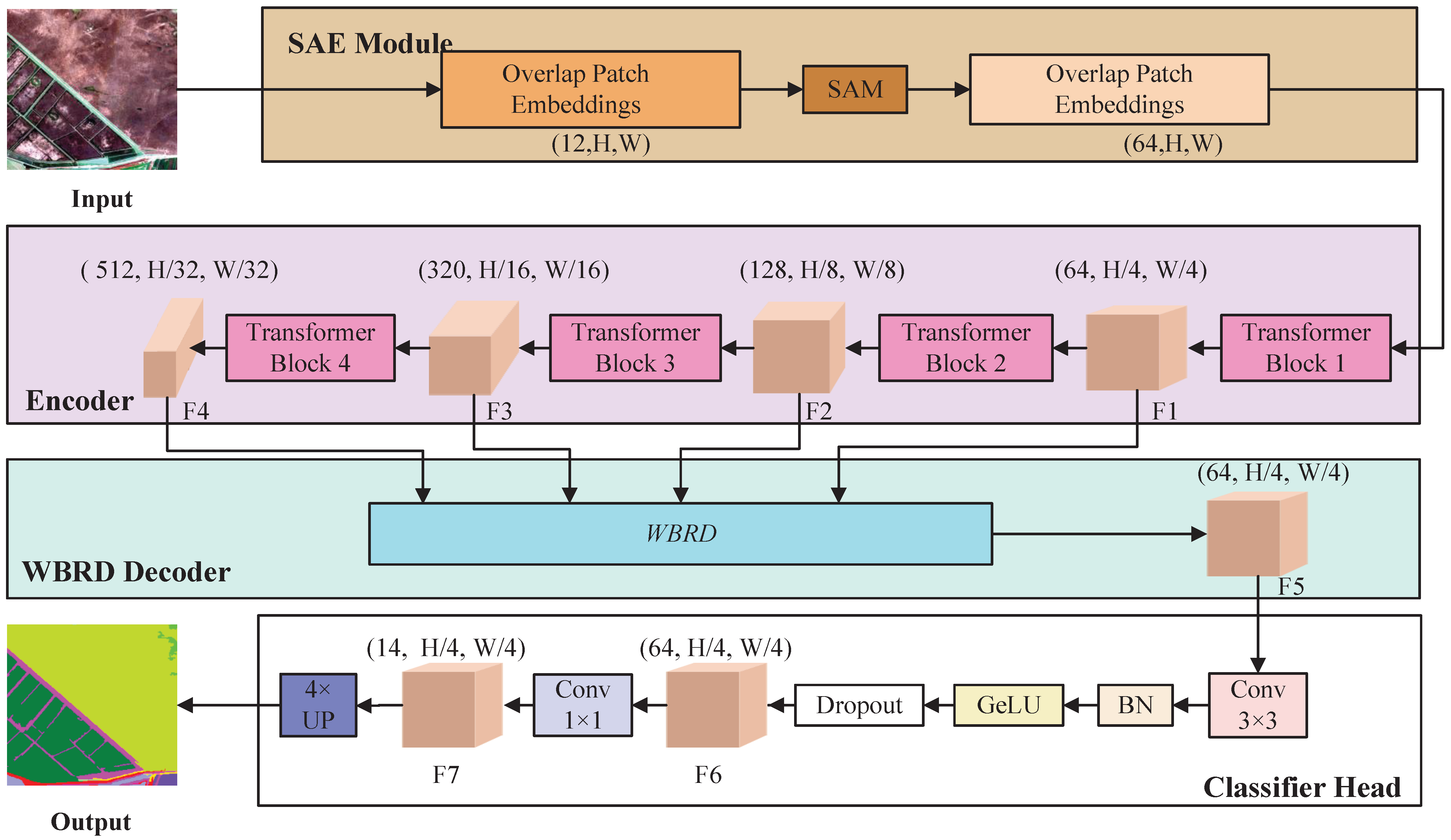
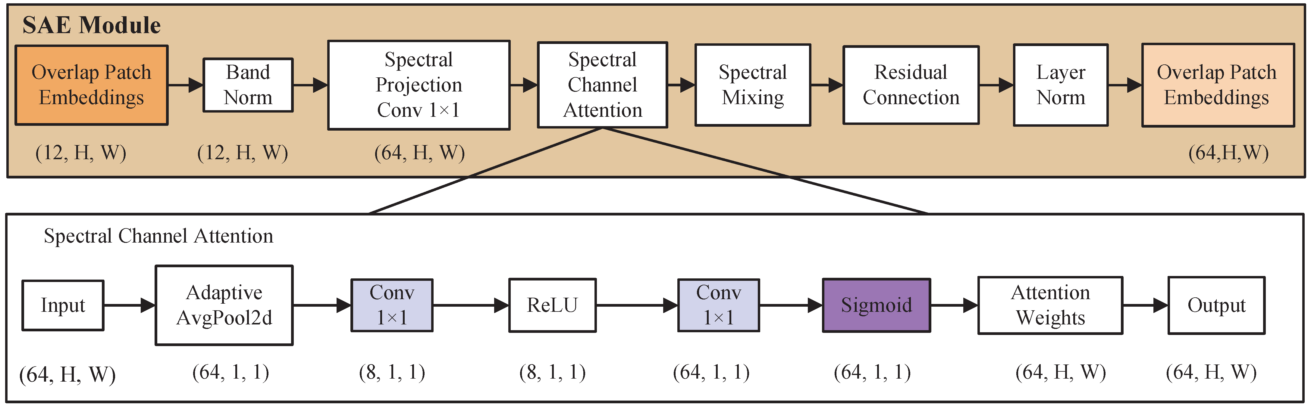
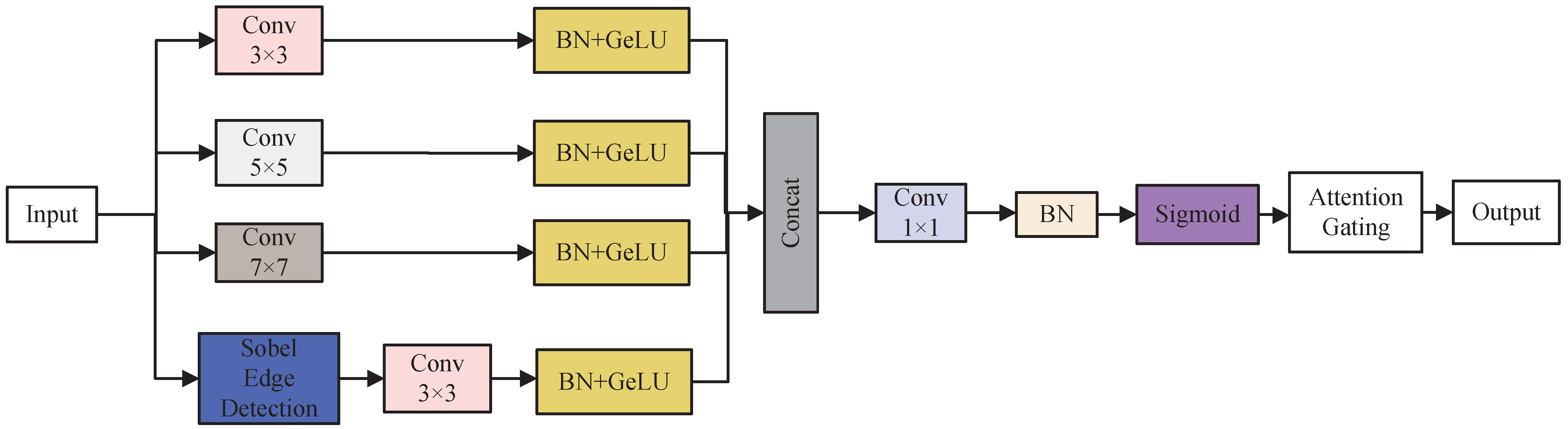
- To address the insufficient utilization of multispectral band information, a Spectral-Aware Embedding (SAE) module is introduced at the encoding stage. This module performs unified modeling and adaptive reweighting of multispectral features, enhancing the effectiveness of spectral information in feature representation;
- (2)
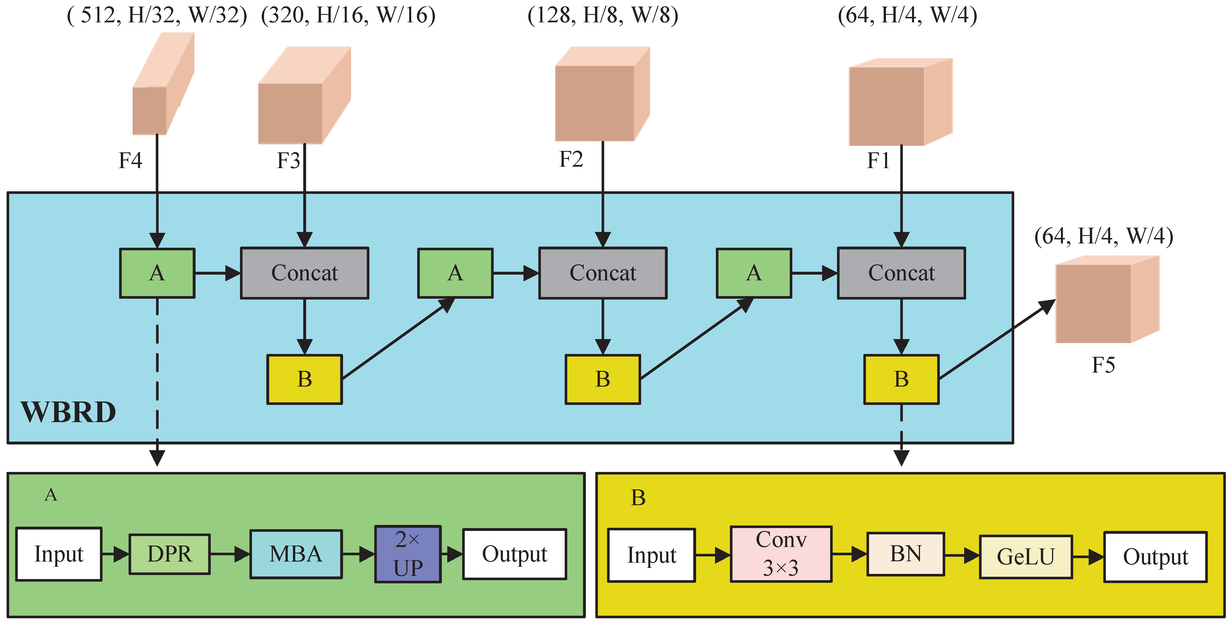
- Considering the fragmented boundaries and complex spatial structures of coastal wetland land-cover types, a Wetland Boundary-Refined Decoder (WBRD) is designed. By incorporating multi-scale feature refinement and boundary-guided enhancement mechanisms, the proposed decoder improves segmentation accuracy for elongated objects and transitional regions;
- (3)
- To mitigate the impact of class imbalance during model training, a Wetland Imbalance Loss (WIL) is constructed. By constraining the gradient contributions of dominant classes, this loss function enhances the learning performance for minority and easily confused land-cover types.
2. Study Area and Data Preprocessing
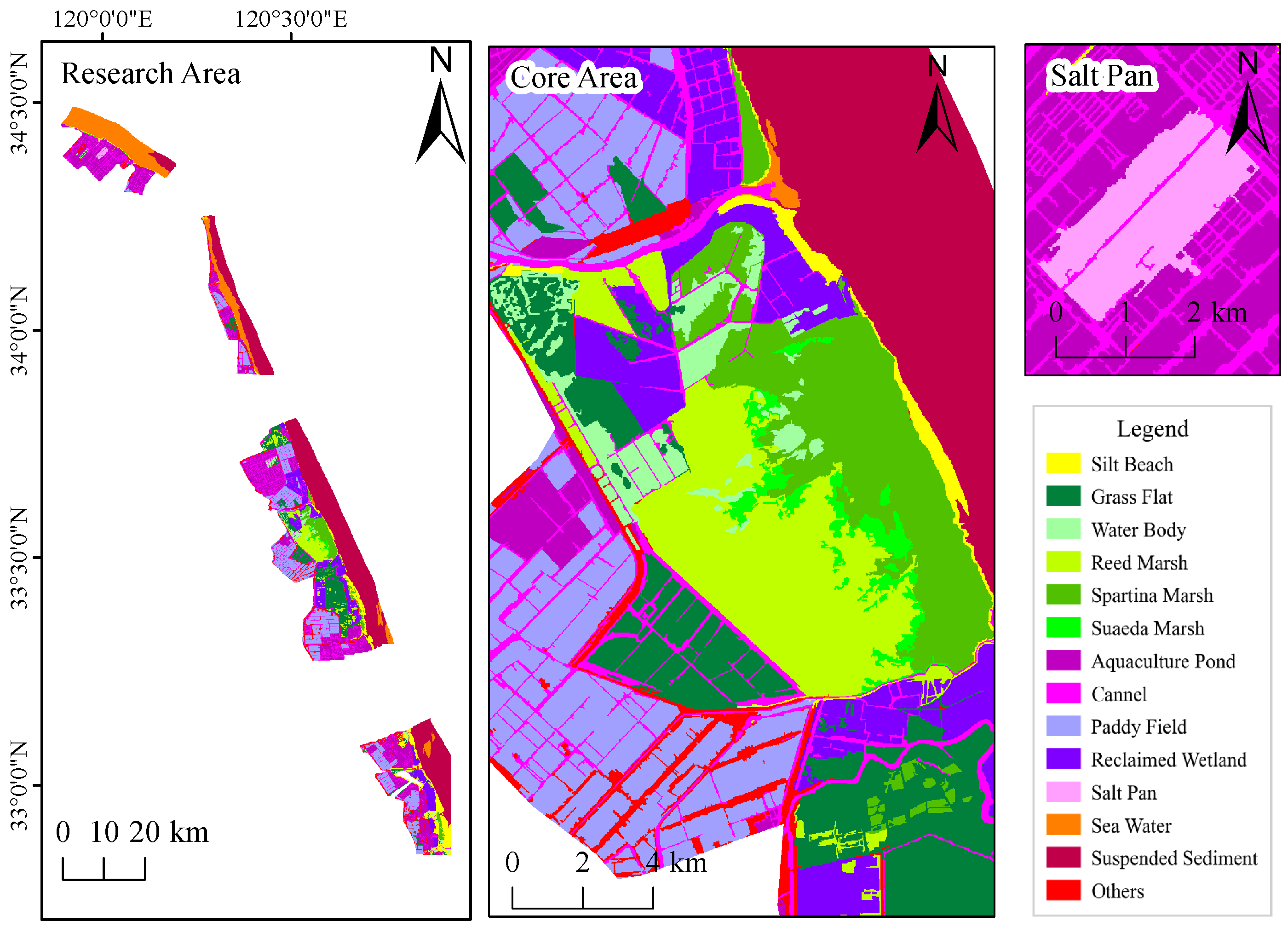
2.1. Study Area Overview
2.2. Data Sources and Remote Sensing Image Preprocessing
2.3. Wetland Classification
2.4. Dataset Construction and Annotation
3. Methods
3.1. Overall Method Framework
3.2. Spectral-Aware Embedding Module (SAE)
3.3. Wetland Boundary-Refined Decoder (WBRD)
- (1)
- a Dual-path Refine (DPR) module for joint texture–boundary feature enhancement.
- (2)
- a Multi-scale Boundary Attention (MBA) module for boundary-aware feature modulation.
3.3.1. Dual-Path Refine Module (DPR)
3.3.2. Multi-Scale Boundary Attention Module (MBA)
3.4. Evaluation Metrics
3.5. Wetland Class Imbalance Loss (WIL)
4. Experiments and Results
4.1. Baseline Model Comparison Experiments
4.2. Ablation Study Design and Results Analysis
4.3. Visual Comparison and Analysis of Segmentation Results
5. Discussion
6. Conclusions
6.1. Research Conclusions
6.2. Research Prospects
Author Contributions
Funding
Data Availability Statement
Conflicts of Interest
References
- Mitsch, W.J.; Bernal, B.; Hernandez, M.E. Ecosystem services of wetlands. Int. J. Biodivers. Sci. Ecosyst. Serv. Manag. 2015, 11, 1–4. [Google Scholar] [CrossRef] [Scilit]
- National Research Council (US) Committee on Low-Frequency Sound and Marine Mammals. Low-Frequency Sound and Marine Mammals; National Academies Press: Washington, DC, USA, 1994. [Google Scholar]
- Tian, B.; Wu, W.T.; Yang, Z.Q.; Zhou, Y.X. Drivers, Trends, and Potential Impacts of Long-Term Coastal Reclamation in China from 1985 to 2010. Estuar. Coast. Shelf Sci. 2016, 170, 83–90. [Google Scholar] [CrossRef] [Scilit]
- Wang, W.; Liu, H.; Li, Y.Q.; Su, J.L. Development and Management of Land Reclamation in China. Ocean Coast. Manag. 2014, 102, 415–425. [Google Scholar] [CrossRef] [Scilit]
- Fournier, R.A.; Grenier, M.; Lavoie, A.; Hélie, R. Towards a Strategy to Implement the Canadian Wetland Inventory Using Satellite Remote Sensing. Can. J. Remote Sens. 2007, 33, S1–S16. [Google Scholar] [CrossRef] [Scilit]
- LaRocque, A.; Phiri, C.; Leblon, B.; Pirotti, F.; Connor, K.; Hanson, A. Wetland Mapping with Landsat 8 OLI, Sentinel-1, ALOS-1 PALSAR, and LiDAR Data in Southern New Brunswick, Canada. Remote Sens. 2020, 12, 2095. [Google Scholar] [CrossRef] [Scilit]
- Yang, J.; Zhao, H.; Luo, Y.H.; Wang, J.D. A Review of Wetland Classification with High-Resolution Remote Sensing Image Based on Deep Learning. Remote Sens. Technol. Appl. 2025, 40, 923–935. [Google Scholar]
- Lv, J.N.; Shen, Q.; Lv, M.Z.; Li, Y.R.; Shi, L.; Zhang, P.Y. Deep Learning-Based Semantic Segmentation of Remote Sensing Images: A Review. Front. Ecol. Evol. 2023, 11, 1201125. [Google Scholar] [CrossRef] [Scilit]
- Liu, Q.W.; Huang, T.; Dong, Y.N.; Yang, J.Q.; Xiang, W. From Pixels to Images: Deep Learning Advances in Remote Sensing Image Semantic Segmentation. arXiv 2025, arXiv:2505.15147. [Google Scholar] [CrossRef] [Scilit]
- Al-Ruzouq, R.; Gibril, M.B.A.; Shanableh, A.; Bolcek, J.; Lamghari, F.; Hammour, N.A.; El-Keblawy, A.; Jena, R. Spectral-Spatial Transformer-Based Semantic Segmentation for Large-Scale Mapping of Individual Date Palm Trees Using Very High-Resolution Satellite Data. Ecol. Indic. 2024, 163, 112110. [Google Scholar] [CrossRef] [Scilit]
- Qian, S.Y.; Xue, Z.H.; Jia, M.M.; Chen, Y.P.; Su, H.J. Temporal-Spectral-Semantic-Aware Convolutional Transformer Network for Multi-Class Tidal Wetland Change Detection in Greater Bay Area. ISPRS J. Photogramm. Remote Sens. 2024, 216, 126–141. [Google Scholar] [CrossRef] [Scilit]
- Marjani, M.; Mohammadimanesh, F.; Mahdianpari, M.; Gill, E.W. A Novel Spatio-Temporal Vision Transformer Model for Improving Wetland Mapping Using Multi-Seasonal Sentinel Data. Remote Sens. Appl. Soc. Environ. 2025, 37, 101401. [Google Scholar] [CrossRef] [Scilit]
- Wang, R.K.; Ma, L.; He, G.J.; Johnson, B.A.; Yan, Z.Y.; Chang, M.; Liang, Y. Transformers for Remote Sensing: A Systematic Review and Analysis. Sensors 2024, 24, 3495. [Google Scholar] [CrossRef] [Scilit]
- Hong, D.F.; Han, Z.; Yao, J.; Gao, L.R.; Zhang, B.; Plaza, A.; Chanussot, J. SpectralFormer: Rethinking Hyperspectral Image Classification with Transformers. IEEE Trans. Geosci. Remote Sens. 2022, 60, 5518615. [Google Scholar] [CrossRef] [Scilit]
- Zhang, Y.; Yang, R.Q.; Dai, Q.L.; Zhao, Y.L.; Xu, W.H.; Wang, J.; Wang, L.G. Boosting Semantic Segmentation of Remote Sensing Images by Introducing Edge Extraction Network and Spectral Indices. Remote Sens. 2023, 15, 5148. [Google Scholar] [CrossRef] [Scilit]
- Lin, X.F.; Cheng, Y.W.; Chen, G.; Chen, W.J.; Chen, R.; Gao, D.M.; Zhang, Y.L.; Wu, Y.B. Semantic Segmentation of China’s Coastal Wetlands Based on Sentinel-2 and Segformer. Remote Sens. 2023, 15, 3714. [Google Scholar] [CrossRef] [Scilit]
- Duan, S.N.; Zhao, J.Y.; Huang, X.Y.; Zhao, S.H. Semantic Segmentation of Remote Sensing Data Based on Channel Attention and Feature Information Entropy. Sensors 2024, 24, 1324. [Google Scholar] [CrossRef] [Scilit] [PubMed]
- Yan, G.D.; Jing, H.T.; Li, H.; Guo, H.C.; He, S. Enhancing Building Segmentation in Remote Sensing Images: Advanced Multi-Scale Boundary Refinement with MBR-HRNet. Remote Sens. 2023, 15, 3766. [Google Scholar] [CrossRef] [Scilit]
- Liu, C.J.; Qiao, Z.; Yan, H.W.; Wu, X.S.; Wang, J.W.; Xin, Y.Q. Semantic Segmentation Network of Remote Sensing Images Based on Dual Path Supervision. J. Beijing Univ. Aeronaut. Astronaut. 2025, 51, 732–741. (In Chinese) [Google Scholar] [CrossRef]
- Yu, J.; Cai, Y.; Lyu, X.; Xu, Z.N.; Wang, X.Y.; Fang, Y.W.; Jiang, W.X.; Li, X. Boundary-Guided Semantic Context Network for Water Body Extraction from Remote Sensing Images. Remote Sens. 2023, 15, 4325. [Google Scholar] [CrossRef] [Scilit]
- Wang, J.Q.; Chen, T.; Zheng, L.; Tie, J.; Zhang, Y.B.; Chen, P.T.; Luo, Z.Q.; Song, Q.J. A Multi-Scale Remote Sensing Semantic Segmentation Model with Boundary Enhancement Based on UNetFormer. Sci. Rep. 2025, 15, 14737. [Google Scholar] [CrossRef] [Scilit]
- Zhang, Y.; Wang, X.; Cai, J.Y.; Yang, Q. MW-SAM: Mangrove Wetland Remote Sensing Image Segmentation Network Based on Segment Anything Model. IET Image Process. 2024, 18, 4503–4513. [Google Scholar] [CrossRef] [Scilit]
- Ke, L.N.; Lu, Y.; Tan, Q.; Zhao, Y.; Wang, Q.M. Precise Mapping of Coastal Wetlands Using Time-Series Remote Sensing Images and Deep Learning Model. Front. For. Glob. Chang. 2024, 7, 1409985. [Google Scholar] [CrossRef] [Scilit]
- Di Vittorio, C.A.; Wiles, M.; Rabby, Y.W.; Movahedi, S.; Louie, J.; Hezrony, L.; Cifuentes, E.C.; Hinchman, W.; Schluter, A. Mapping Coastal Wetland Changes from 1985 to 2022 in the US Atlantic and Gulf Coasts Using Landsat Time Series and National Wetland Inventories. Remote Sens. Appl. Soc. Environ. 2025, 37, 101392. [Google Scholar] [CrossRef] [Scilit]
- Yuan, S.; Liang, X.G.; Lin, T.W.; Chen, S.; Liu, R.; Wang, J.; Zhang, H.S.; Gong, P. A Comprehensive Review of Remote Sensing in Wetland Classification and Mapping. arXiv 2025, arXiv:2504.10842. [Google Scholar] [CrossRef] [Scilit]
- Effah, D.; Zia, A.; Awrangjeb, M.; Gao, Y.S.; Sarpong, K. Advances in Machine Learning for Wetland Classification: A Comprehensive Survey of Methods and Applications. Artif. Intell. Rev. 2025, 59, 24. [Google Scholar] [CrossRef] [Scilit]
- Istiak, M.A.; Khan, R.H.; Rony, J.H.; Syeed, M.M.M.; Ashrafuzzaman, M.; Karim, M.R.; Hossain, M.S.; Uddin, M.F. AqUavplant Dataset: A High-Resolution Aquatic Plant Classification and Segmentation Image Dataset Using UAV. Sci. Data 2024, 11, 1411. [Google Scholar] [CrossRef] [Scilit]
- Xie, E.; Wang, W.H.; Yu, Z.D.; Anandkumar, A.; Alvarez, J.M.; Luo, P. SegFormer: Simple and Efficient Design for Semantic Segmentation with Transformers. Adv. Neural Inf. Process. Syst. 2021, 34, 12077–12090. [Google Scholar] [CrossRef] [Scilit]
- Vaswani, A.; Shazeer, N.; Parmar, N.; Uszkoreit, J.; Jones, L.; Gomez, A.N.; Kaiser, Ł.; Polosukhin, I. Attention Is All You Need. Adv. Neural Inf. Process. Syst. 2017, 30, 6000–6010. [Google Scholar] [CrossRef] [Scilit]
- Dosovitskiy, A. An Image is Worth 16x16 Words: Transformers for Image Recognition at Scale. arXiv 2020, arXiv:2010.11929. [Google Scholar] [CrossRef] [Scilit]
- Yu, S.B.; Yang, H.; Wang, C.F.; Luo, D.S. Remote Sensing Information Extraction of Yancheng Wetland Rare Bird Reserve Based on Multi-Feature Optimization. Remote Sens. Technol. Appl. 2025, 40, 734–747. [Google Scholar]
- Li, J.L.; Tong, C.; Huang, R.P.; Tian, P.; Liu, R.Q.; Wang, L.J.; Zhou, Z.J. Spatio-Temporal Evolution of Coastal Wetlands Affected by Human Activities: A Case Study of Yancheng City, South Coast of Hangzhou Bay and Xiangshan Harbor Wetlands. J. Ningbo Univ. (Nat. Sci. Eng. Ed.) 2020, 33, 1–9. [Google Scholar]
- Li, J.X. Habitat Changes of Red-Crowned Cranes Derived from Remote Sensing Data in the Yancheng Coastal Wetland During 1989–2019. Master’s Thesis, University of Chinese Academy of Sciences (Aerospace Information Research Institute, Chinese Academy of Sciences), Beijing, China, 2021. [Google Scholar]
- Tan, C.W.; Wang, D.L.; Zhou, J.; Du, Y.; Luo, M.; Guo, W.S. Estimation of Leaf Nitrogen Concentration in Wheat by the Combinations of Two Vegetation Indexes Using HJ-CCD Images. Int. J. Agric. Biol. 2018, 20, 1908–1914. [Google Scholar]
- Wang, C.; Liu, H.Y.; Li, Y.F.; Wang, G.; Dong, B.; Chen, H.; Zhang, Y.N.; Zhao, Y.Q. A Study on Habitat Suitability and Ecological Threshold of Waterbird Guilds in Yancheng Coastal Wetlands: Implications for Habitat Structure Restoration. J. Ecol. Rural Environ. 2022, 38, 897–908. [Google Scholar] [CrossRef]
- Rouse, J.W., Jr.; Haas, R.H.; Schell, J.A.; Deering, D.W. Monitoring the Vernal Advancement and Retrogradation (Green Wave Effect) of Natural Vegetation; NASA: Washington, DC, USA, 1973. [Google Scholar]
- McFeeters, S.K. The Use of the Normalized Difference Water Index (NDWI) in the Delineation of Open Water Features. Int. J. Remote Sens. 1996, 17, 1425–1432. [Google Scholar] [CrossRef] [Scilit]
- Xu, H.Q. Modification of Normalised Difference Water Index (NDWI) to Enhance Open Water Features in Remotely Sensed Imagery. Int. J. Remote Sens. 2006, 27, 3025–3033. [Google Scholar] [CrossRef] [Scilit]
- Hu, J.; Shen, L.; Sun, G. Squeeze-and-Excitation Networks. In Proceedings of the IEEE Conference on Computer Vision and Pattern Recognition (CVPR), Salt Lake City, UT, USA, 18–22 June 2018; pp. 7132–7141. [Google Scholar] [CrossRef] [Scilit]
- Wassan, S.; Bilal, A.; Alzahrani, A.; Almohammadi, K.; Alrashidi, M.; Mousavirad, S.J. A Modified Vision Transformer Framework for Image-Based Land Cover Segmentation in Rural Architectural Design and Planning. Sci. Rep. 2025, 15, 32658. [Google Scholar] [CrossRef] [Scilit]
- Aouayeb, M.; Hamidouche, W.; Soladie, C.; Kpalma, K.; Seguier, R. Learning Vision Transformer with Squeeze and Excitation for Facial Expression Recognition. arXiv 2021, arXiv:2107.03107. [Google Scholar] [CrossRef] [Scilit]
- Dice, L.R. Measures of the Amount of Ecologic Association between Species. Ecology 1945, 26, 297–302. [Google Scholar] [CrossRef] [Scilit]
- Milletari, F.; Navab, N.; Ahmadi, S.A. V-Net: Fully Convolutional Neural Networks for Volumetric Medical Image Segmentation. In Proceedings of the 2016 Fourth International Conference on 3D Vision (3DV), Stanford, CA, USA, 25–28 October 2016; pp. 565–571. [Google Scholar] [CrossRef] [Scilit]
- Lin, T.Y.; Goyal, P.; Girshick, R.; He, K.M.; Dollár, P. Focal Loss for Dense Object Detection. In Proceedings of the 2017 IEEE International Conference on Computer Vision (ICCV), Venice, Italy, 22–29 October 2017; pp. 2980–2988. [Google Scholar] [CrossRef] [Scilit]
- Isensee, F.; Jaeger, P.F.; Kohl, S.A.A.; Petersen, J.; Maier-Hein, K.H. nnU-Net: A Self-Configuring Method for Deep Learning-Based Biomedical Image Segmentation. Nat. Methods 2021, 18, 203–211. [Google Scholar] [CrossRef] [Scilit]
- Gao, K.; Wang, F.; Liu, Z.; Wang, M. Semantic Segmentation of Remote Sensing Images Based on Improved U-Net. J. Jilin Univ. (Earth Sci. Ed.) 2024, 54, 1752–1763. [Google Scholar]
- Elgamily, K.M.; Mohamed, M.A.; Abou-Taleb, A.M.; Ata, M.M. A novel W13 deep CNN structure for improved semantic segmentation of multiple objects in remote sensing imagery. Neural Comput. Appl. 2025, 37, 5397–5427. [Google Scholar] [CrossRef] [Scilit]
- Long, J.; Shelhamer, E.; Darrell, T. Fully Convolutional Networks for Semantic Segmentation. In Proceedings of the 2015 IEEE Conference on Computer Vision and Pattern Recognition (CVPR), Boston, MA, USA, 7–12 June 2015; pp. 3431–3440. [Google Scholar] [CrossRef] [Scilit]
- Ronneberger, O.; Fischer, P.; Brox, T. U-Net: Convolutional Networks for Biomedical Image Segmentation. In Proceedings of the Medical Image Computing and Computer-Assisted Intervention (MICCAI 2015), Munich, Germany, 5–9 October 2015; pp. 234–241. [Google Scholar] [CrossRef] [Scilit]
- Zhao, H.S.; Shi, J.P.; Qi, X.J.; Wang, X.G.; Jia, J.Y. Pyramid Scene Parsing Network. In Proceedings of the IEEE Conference on Computer Vision and Pattern Recognition (CVPR), Honolulu, HI, USA, 21–26 July 2017; pp. 6230–6239. [Google Scholar] [CrossRef] [Scilit]
- Chen, L.C.; Zhu, Y.K.; Papandreou, G.; Schroff, F.; Adam, H. Encoder-Decoder with Atrous Separable Convolution for Semantic Image Segmentation. In Proceedings of the European Conference on Computer Vision (ECCV), Munich, Germany, 8–14 September 2018. [Google Scholar] [CrossRef] [Scilit]
- Xiao, T.; Liu, Y.C.; Zhou, B.L.; Jiang, Y.N.; Sun, J. Unified Perceptual Parsing for Scene Understanding. In Proceedings of the European Conference on Computer Vision (ECCV), Munich, Germany, 8–14 September 2018; pp. 418–434. [Google Scholar] [CrossRef] [Scilit]
- Cao, Y.; Xu, J.R.; Lin, S.; Wei, F.Y.; Hu, H. GCNet: Non-Local Networks Meet Squeeze-Excitation Networks and Beyond. In Proceedings of the IEEE/CVF International Conference on Computer Vision (ICCV) Workshops, Seoul, Korea, 27–28 October 2019. [Google Scholar] [CrossRef] [Scilit]
- Liu, Z.; Lin, Y.T.; Cao, Y.; Hu, H.; Wei, Y.X.; Zhang, Z.; Lin, S.; Guo, B.N. Swin Transformer: Hierarchical Vision Transformer using Shifted Windows. In Proceedings of the 2021 IEEE/CVF International Conference on Computer Vision (ICCV), Montreal, QC, Canada, 11–17 October 2021; pp. 9992–10002. [Google Scholar] [CrossRef] [Scilit]
- Gu, P.; Zhang, Y.; Wang, C.; Chen, D.Z. ConvFormer: Combining CNN and Transformer for Medical Image Segmentation. In Proceedings of the 2023 IEEE 20th International Symposium on Biomedical Imaging (ISBI), Cartagena, Colombia, 18–21 April 2023; pp. 1–5. [Google Scholar] [CrossRef] [Scilit]
- Wang, L.; Li, R.; Zhang, C.; Fang, S.; Duan, C.; Meng, X.; Atkinson, P.M. UNetFormer: A UNet-like transformer for efficient semantic segmentation of remote sensing urban scene imagery. ISPRS J. Photogramm. Remote Sens. 2022, 190, 196–214. [Google Scholar] [CrossRef] [Scilit]
- Qin, D.; Leichner, C.; Delakis, M.; Fornoni, M.; Luo, S.; Yang, F.; Wang, W.; Banbury, C.; Ye, C.; Akin, B.; et al. MobileNetV4: Universal Models for the Mobile Ecosystem. In Proceedings of the European Conference on Computer Vision (ECCV), Milan, Italy, 29 September–4 October 2024; pp. 78–96. [Google Scholar] [CrossRef] [Scilit]






| Image Acquisition Date | Baseline/Orbit Number | Satellite | Mosaic Domain Number |
|---|---|---|---|
| 3 January 2023/02:41:09 | N0510/R089 | 2A | T51STT |
| 14 March 2023/02:35:29 | N0510/R089 | 2A | T51STT |
| 27 March 2023/02:45:29 | N0510/R132 | 2A | T50SQD |
| 23 May 2023/02:35:39 | N0510/R089 | 2A | T51STU |
| 23 May 2023/02:35:39 | N0510/R089 | 2A | T51STT |
| 31 August 2023/02:35:29 | N0510/R089 | 2A | T51STU |
| 15 October 2023/02:36:51 | N0510/R089 | 2A | T51STT |
| 23 October 2023/02:47:49 | N0510/R132 | 2A | T51STU |
| 30 October 2023/02:38:29 | N0510/R089 | 2A | T51STT |
| 19 November 2023/02:40:09 | N0510/R089 | 2A | T51STT |
| 7 December 2023/02:51:01 | N0510/R132 | 2A | T50SQD |
| 12 February 2024/02:38:31 | N0510/R089 | 2A | T51STT |
| 12 February 2024/02:38:31 | N0510/R089 | 2A | T51STS |
| 12 February 2024/02:38:31 | N0510/R089 | 2A | T51SUS |
| 22 April 2024/02:35:31 | N0510/R089 | 2A | T51STT 1 |
| 22 April 2024/02:35:31 | N0510/R089 | 2A | T51STU |
| 7 May 2024/02:35:29 | N0510/R089 | 2A | T51STS |
| 31 July 2024/02:35:51 | N0511/R089 | 2A | T51STS |
| 31 July 2024/02:35:51 | N0511/R089 | 2A | T51STT 2 |
| 31 July 2024/02:35:51 | N0511/R089 | 2A | T51STU |
| 24 October 2024/02:36:59 | N0511/R089 | 2A | T51STT |
| 28 November 2024/02:40:31 | N0511/R089 | 2A | T51STT |
| 28 November 2024/02:40:31 | N0511/R089 | 2A | T51STS |
| 28 November 2024/02:40:31 | N0511/R089 | 2A | T51SUS |
| 28 November 2024/02:40:31 | N0511/R089 | 2A | T51STU |
| 28 November 2024/02:40:31 | N0511/R089 | 2A | T50SQC |
| 28 December 2024/02:41:21 | N0511/R089 | 2A | T51STT |
| 28 December 2024/02:41:21 | N0511/R089 | 2A | T51STS |
| 28 December 2024/02:41:21 | N0511/R089 | 2A | T50SQC |
| 28 December 2024/02:41:21 | N0511/R089 | 2A | T51STU |
| Primary Category | Secondary Category | Category Description |
|---|---|---|
| Natural Wetland | Silt Beach | High water content, low spectral reflectance, exposed intertidal mudflat |
| Grass Flat | Areas with sparse vegetation coverage and no distinct dominant species | |
| Water Body | Residual water surfaces and other natural water bodies | |
| Reed Marsh | Marsh vegetation type dominated by reeds | |
| Spartina Marsh | Marsh vegetation type dominated by Spartina alterniflora | |
| Suaeda Marsh | Marsh vegetation type dominated by Suaeda salsa | |
| Artificial Wetland | Aquaculture Pond | Regular rectangular ponds, primarily used for aquaculture |
| Channel | Drainage/irrigation ditches and small linear water bodies | |
| Paddy Field | Agricultural cultivation area with periodic vegetation changes | |
| Reclaimed Wetland | Undergoing restoration, with complex mixed feature distribution | |
| Salt Pan | Artificial evaporation ponds, high reflectance, grid-like structure | |
| Non-Wetland | Sea Water | Deep water areas, high blue light reflectance |
| Suspended Sediment | Highly turbid water bodies influenced by tides or runoff | |
| Others | Roads, buildings, bare land, and other non-wetland categories |
| Dataset | Silt B. | Grass F. | Water B. | Reed M. | Spart. M. | Suaeda M. | Aqua. P. | Chan. | Paddy F. | Recl. Wet. | Salt P. | Sea W. | Susp. Sed. | Others |
|---|---|---|---|---|---|---|---|---|---|---|---|---|---|---|
| TRAIN | 2392 | 2420 | 1745 | 1770 | 1383 | 747 | 2331 | 3720 | 1678 | 1836 | 233 | 1337 | 2115 | 2780 |
| VAL | 177 | 189 | 138 | 178 | 158 | 151 | 159 | 315 | 100 | 77 | 59 | 111 | 171 | 114 |
| TEST | 185 | 128 | 152 | 154 | 159 | 73 | 113 | 210 | 83 | 168 | 28 | 145 | 287 | 163 |
| Category Name | Pixel Count | Percentage |
|---|---|---|
| Suspended Sediment | 190,729,662 | 20.73% |
| Aquaculture Pond | 105,326,248 | 11.45% |
| Grass Flat | 92,850,762 | 10.09% |
| Sea Water | 86,967,484 | 9.45% |
| Reed Marsh | 85,217,218 | 9.26% |
| Reclaimed Wetland | 71,556,077 | 7.78% |
| Paddy Field | 69,126,640 | 7.51% |
| Channel | 61,247,899 | 6.66% |
| Spartina Marsh | 59,873,345 | 6.51% |
| Others | 32,649,096 | 3.55% |
| Silt Beach | 25,793,725 | 2.80% |
| Water Body | 22,130,135 | 2.41% |
| Suaeda Marsh | 13,124,811 | 1.43% |
| Salt Pan | 3,536,245 | 0.38% |
| Experimental Background | Version/Environment |
|---|---|
| PyTorch | 2.1.0 |
| Python | 3.10 |
| Ubuntu | 22.04 |
| CUDA | 12.1 |
| GPU | RTX 3090 (24G) |
| CPU | 20 vCPU AMD EPYC 7642 48-Core Processor |
| Training Epochs | 120 |
| Batch size | 8 |
| Optimizer | AdamW |
| Model | mIoU | PA | mF1 | mRecall | mPrecision | Best Epoch |
|---|---|---|---|---|---|---|
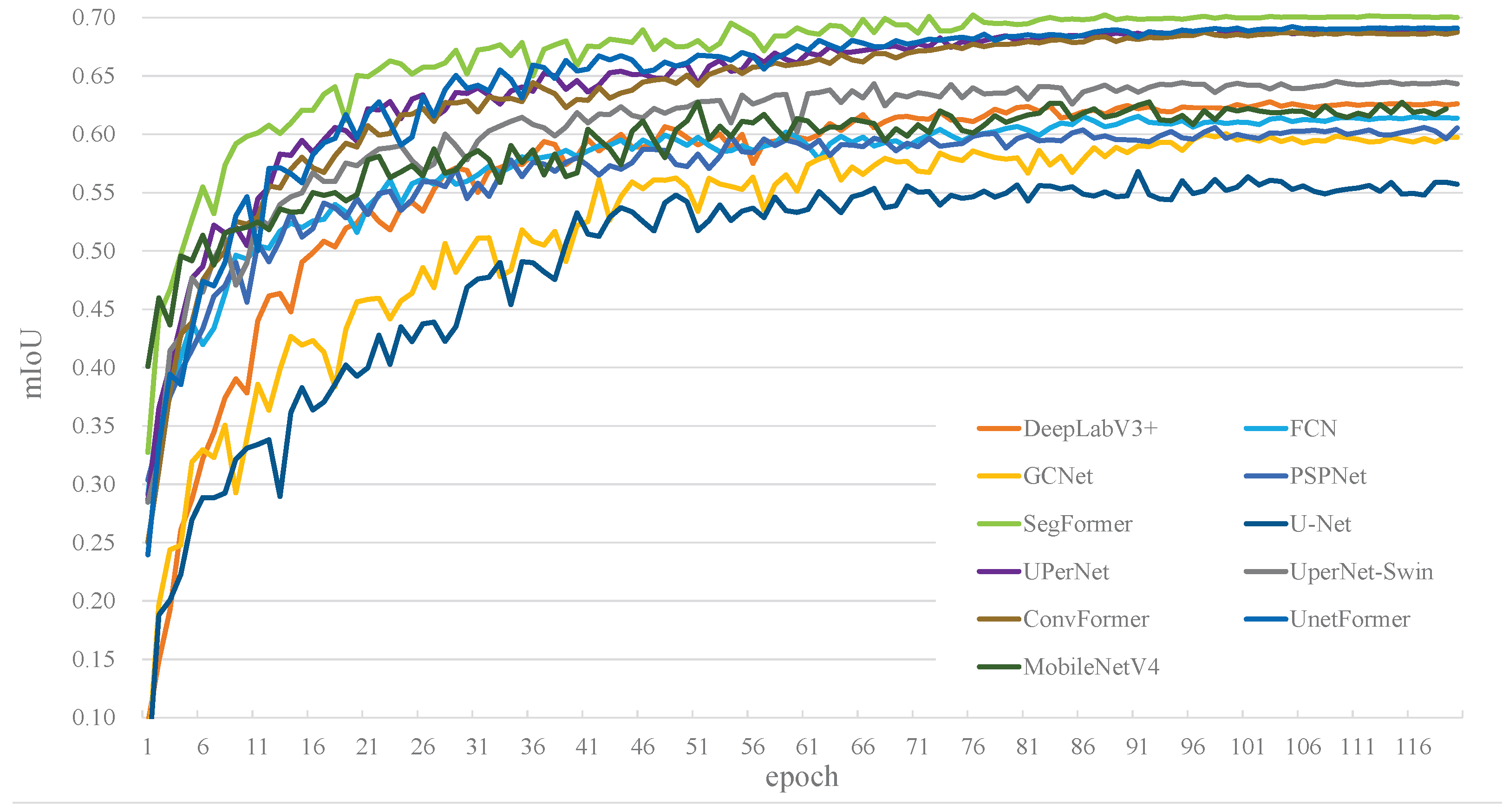
| SegFormer | 0.7022 | 0.9537 | 0.8236 | 0.8373 | 0.8155 | 88 |
| UnetFormer | 0.6922 | 0.9359 | 0.8110 | 0.8224 | 0.8193 | 105 |
| UPerNet | 0.6891 | 0.9446 | 0.8091 | 0.8175 | 0.8127 | 110 |
| ConvFormer | 0.6873 | 0.9491 | 0.8151 | 0.8285 | 0.8104 | 97 |
| UperNet-Swin | 0.6452 | 0.9318 | 0.7833 | 0.7931 | 0.7823 | 109 |
| DeepLabV3+ | 0.6278 | 0.9401 | 0.7796 | 0.7883 | 0.7762 | 103 |
| MobileNetV4 | 0.6276 | 0.9355 | 0.7728 | 0.7758 | 0.7751 | 93 |
| FCN | 0.6153 | 0.9310 | 0.7605 | 0.7683 | 0.7612 | 91 |
| PSPNet | 0.6057 | 0.8918 | 0.7542 | 0.7558 | 0.7551 | 98 |
| GCNet | 0.6004 | 0.9382 | 0.7453 | 0.7521 | 0.7399 | 99 |
| U-Net | 0.5679 | 0.9378 | 0.7264 | 0.7392 | 0.7218 | 91 |
| Model | Parameters (M) | FLOPs (G) | FPS |
|---|---|---|---|
| FCN | 26.15 | 33.29 | 125.30 |
| U-Net | 32.55 | 45.21 | 118.20 |
| PSPNet | 25.31 | 37.99 | 124.91 |
| DeepLabV3+ | 26.71 | 38.85 | 128.27 |
| UPerNet | 37.31 | 157.32 | 88.88 |
| UperNet-Swin | 84.18 | 242.56 | 45.23 |
| SegFormer | 24.73 | 56.14 | 148.65 |
| GCNet | 26.29 | 25.37 | 167.78 |
| ConvFormer | 45.70 | 267.07 | 42.86 |
| UnetFormer | 26.85 | 84.62 | 78.94 |
| MobileNetV4 | 12.81 | 42.04 | 139.21 |
| Class Name | FCN | U-Net | PSPNet | Deep. 1 | UPerNet | UP.-Swin 2 | SegF. 3 | GCNet | ConvF. 4 | UnetF. 5 | MobileV4 6 |
|---|---|---|---|---|---|---|---|---|---|---|---|
| Silt Beach | 0.5996 | 0.5229 | 0.5523 | 0.6059 | 0.6556 | 0.6094 | 0.6879 | 0.6156 | 0.6225 | 0.6069 | 0.6015 |
| Grass Flat | 0.5420 | 0.5166 | 0.4862 | 0.5304 | 0.5522 | 0.5178 | 0.6109 | 0.5203 | 0.5762 | 0.6011 | 0.5597 |
| Water Body | 0.6251 | 0.5919 | 0.5235 | 0.5121 | 0.6863 | 0.5599 | 0.6531 | 0.6334 | 0.6142 | 0.6801 | 0.6361 |
| Reed Marsh | 0.5233 | 0.4881 | 0.5146 | 0.6043 | 0.6209 | 0.5182 | 0.6373 | 0.5379 | 0.5832 | 0.6552 | 0.5242 |
| Spartina Marsh | 0.5958 | 0.5302 | 0.5449 | 0.6259 | 0.6856 | 0.5724 | 0.6787 | 0.5935 | 0.5795 | 0.6774 | 0.5159 |
| Suaeda Marsh | 0.5034 | 0.4821 | 0.4526 | 0.4386 | 0.5251 | 0.4328 | 0.5638 | 0.4680 | 0.4215 | 0.5286 | 0.4559 |
| Aquaculture Pond | 0.6367 | 0.4662 | 0.5517 | 0.6118 | 0.6974 | 0.5422 | 0.7064 | 0.5991 | 0.6604 | 0.6932 | 0.6143 |
| Channel | 0.4379 | 0.4566 | 0.4191 | 0.4256 | 0.5283 | 0.5358 | 0.5454 | 0.4156 | 0.5069 | 0.5279 | 0.4946 |
| Paddy Field | 0.6921 | 0.6179 | 0.6298 | 0.7624 | 0.8076 | 0.6631 | 0.8101 | 0.6185 | 0.7691 | 0.8139 | 0.6137 |
| Reclaimed Wetland | 0.5574 | 0.5655 | 0.5258 | 0.6137 | 0.7324 | 0.6205 | 0.7385 | 0.5667 | 0.6247 | 0.7334 | 0.6485 |
| Salt Pan | 0.6159 | 0.5223 | 0.5114 | 0.6944 | 0.7294 | 0.5837 | 0.7684 | 0.6280 | 0.6151 | 0.7316 | 0.7501 |
| Seawater | 0.8153 | 0.7859 | 0.7443 | 0.8101 | 0.8425 | 0.7567 | 0.8433 | 0.7728 | 0.8111 | 0.8292 | 0.8297 |
| Suspended Sediment | 0.9428 | 0.8947 | 0.8824 | 0.9572 | 0.9520 | 0.9024 | 0.9546 | 0.9239 | 0.9549 | 0.9427 | 0.9354 |
| Other | 0.5261 | 0.5104 | 0.5362 | 0.5967 | 0.6323 | 0.5725 | 0.6326 | 0.5120 | 0.5964 | 0.6688 | 0.6064 |
| SAE | WBRD | WIL | mIoU | PA | mF1 | mRecall | mPrecision | Params (M) | FLOPs (G) | FPS |
|---|---|---|---|---|---|---|---|---|---|---|
| × | × | × | 0.7022 | 0.9537 | 0.8236 | 0.8373 | 0.8197 | 24.73 | 56.14 | 148.65 |
| ✔ | × | × | 0.7185 | 0.9574 | 0.8347 | 0.8401 | 0.8358 | 24.74 | 58.57 | 142.45 |
| ✔ | ✔ | × | 0.7327 | 0.9618 | 0.8378 | 0.8423 | 0.8391 | 26.97 | 99.96 | 83.4 |
| ✔ | ✔ | ✔ | 0.7459 | 0.9674 | 0.8551 | 0.8665 | 0.8513 | 27.2 | 103.6 | 75.26 |
| Category | SegFormer | SegFormer+SAE | SegFormer+SAE+WBRD | Full Model |
|---|---|---|---|---|
| Silt Beach | 0.6879 | 0.6917 | 0.7147 | 0.7357 |
| Grass Flat | 0.6109 | 0.7103 | 0.7214 | 0.7198 |
| Water Body | 0.6531 | 0.6748 | 0.6723 | 0.6851 |
| Reed Marsh | 0.6373 | 0.6731 | 0.7213 | 0.7228 |
| Spartina Marsh | 0.6787 | 0.6813 | 0.6914 | 0.6998 |
| Suaeda Marsh | 0.5638 | 0.5755 | 0.5941 | 0.6046 |
| Aquaculture Pond | 0.7064 | 0.7167 | 0.7452 | 0.7511 |
| Channel | 0.5454 | 0.5507 | 0.5927 | 0.6193 |
| Paddy Field | 0.8101 | 0.8197 | 0.8270 | 0.8222 |
| Reclaimed Wetland | 0.7385 | 0.7428 | 0.7617 | 0.7685 |
| Salt Pan | 0.7684 | 0.7763 | 0.7701 | 0.7916 |
| Seawater | 0.8433 | 0.8642 | 0.8636 | 0.8698 |
| Suspended Sediment | 0.9546 | 0.9548 | 0.9511 | 0.9629 |
| Other | 0.6326 | 0.6273 | 0.6317 | 0.6888 |
| mIoU | 0.7022 | 0.7185 | 0.7327 | 0.7459 |
Disclaimer/Publisher’s Note: The statements, opinions and data contained in all publications are solely those of the individual author(s) and contributor(s) and not of MDPI and/or the editor(s). MDPI and/or the editor(s) disclaim responsibility for any injury to people or property resulting from any ideas, methods, instructions or products referred to in the content. |
© 2026 by the authors. Licensee MDPI, Basel, Switzerland. This article is an open access article distributed under the terms and conditions of the Creative Commons Attribution (CC BY) license.
Share and Cite
Peng, S.; Xie, H.; Liu, N.; Zeng, Y. Semantic Segmentation of Multispectral Remote Sensing Imagery for Coastal Wetlands with SegFormer. Remote Sens. 2026, 18, 745. https://doi.org/10.3390/rs18050745
Peng S, Xie H, Liu N, Zeng Y. Semantic Segmentation of Multispectral Remote Sensing Imagery for Coastal Wetlands with SegFormer. Remote Sensing. 2026; 18(5):745. https://doi.org/10.3390/rs18050745
Chicago/Turabian StylePeng, Simin, Huachen Xie, Nian Liu, and Yi Zeng. 2026. "Semantic Segmentation of Multispectral Remote Sensing Imagery for Coastal Wetlands with SegFormer" Remote Sensing 18, no. 5: 745. https://doi.org/10.3390/rs18050745
APA StylePeng, S., Xie, H., Liu, N., & Zeng, Y. (2026). Semantic Segmentation of Multispectral Remote Sensing Imagery for Coastal Wetlands with SegFormer. Remote Sensing, 18(5), 745. https://doi.org/10.3390/rs18050745