Article

GFE-Net: Geometry-Enhanced Feature Extraction Network for Semantic Segmentation of Large-Scale LiDAR Point Clouds

1
College of Electrical Engineering and Control Science, Nanjing Tech University, Nanjing 211816, China
2
Administrative Department, Nanjing University of Industry Technology, Nanjing 210023, China
3
School of Electrical and Energy Engineering, Nantong Institute of Technology, Nantong 226002, China
*
Author to whom correspondence should be addressed.
Remote Sens. 2026, 18(17), 2990; https://doi.org/10.3390/rs18172990
Submission received: 24 June 2026 / Revised: 28 August 2026 / Accepted: 30 August 2026 / Published: 3 September 2026
(This article belongs to the Section Remote Sensing Image Processing)

Highlights

What are the main findings?
  • Integrated Geometry-Enhanced Framework: We propose GFE-Net, a robust segmentation framework for large-scale LiDAR point clouds, which significantly improves segmentation accuracy through the synergy of three novel components: the SGNA module for density-adaptive aggregation, the LGIE module for local–global feature interaction, and the NPC loss for boundary regularization.
  • Accuracy–Cost Characterization: Evaluations on S3DIS and SensatUrban show competitive segmentation accuracy. Efficiency profiling reports giga floating-point operations (GFLOPs), parameter count, and training time; GFE-Net uses fewer GFLOPs and less training time than PTv/PTv2, while its parameter count remains higher than that of RandLA-Net and slightly higher than that of LACV-Net.
What are the implications of the main findings?
  • Practical Urban Modeling: The proposed hierarchical encoder–decoder provides a reproducible framework for large-scale 3D parsing, enabling cost-controlled deployment by quantitatively characterizing efficiency in terms of parameters, GFLOPs, and running time.
  • Boundary Precision Enhancement: By enforcing spatial consistency via the NPC loss, this work provides a theoretically sound approach to resolve semantic ambiguity at complex object interfaces, which is crucial for high-fidelity digital twin construction and geographic information retrieval.

Abstract

Accurate semantic segmentation of large-scale outdoor LiDAR point clouds remains a challenging endeavor, primarily due to ambiguous class transitions at object interfaces, non-uniform sampling density across the surveyed area, and shared geometric signatures among distinct object categories. This paper proposes GFE-Net (Geometry-Enhanced Feature Extraction Network), a hierarchical encoder–decoder architecture that systematically improves per-point feature characterization through three complementary design contributions: First, to mitigate the shortcomings of conventional fixed-neighborhood queries in regions of variable point density, a Structure-Guided Neighborhood Adaptation (SGNA) module is devised. At its core lies a morphology-driven contextual gating (MCG) unit that synthesizes neighbor-wise calibration weights from hierarchical shape descriptors fused with elevation difference statistics, allowing the network to preferentially amplify morphologically congruent neighbors while dampening spurious or cross-boundary contributions. Second, to strengthen semantic discrimination beyond what spatial locality alone affords, a Local–Global Interactive Enhancement (LGIE) module is presented. The LGIE module simultaneously distills precise local structure through Euclidean-space neighborhood graphs and captures scene-wide co-activation patterns via compact bilinear factorization of the latent feature space, merging both streams through a residual refinement mechanism that markedly improves inter-class separability. Third, to enforce label consistency at object interfaces without relying on post-processing heuristics, a Neighborhood Prediction Consistency (NPC) loss is introduced. Built upon a Gaussian distance-decay weighting kernel, the NPC loss assigns progressively stronger penalties to label mismatches between a query point and its geometrically proximate neighbors, thereby promoting spatially coherent predictions and attenuating boundary noise. GFE-Net is rigorously benchmarked on two widely adopted large-scale datasets—S3DIS and SensatUrban—yielding OA/mIoU of 89.6%/73.1% and 93.3%/61.1%, respectively. These results demonstrate competitive performance under the reported protocols. Detailed ablation studies and computational profiling further substantiate the efficacy of each individual component.

1. Introduction

Interpreting three-dimensional scenes from raw point-cloud data has become a focal research topic spanning the computer vision and geospatial intelligence communities. Although point-cloud analysis already underpins diverse applications—from intraoperative surgical guidance and immersive virtual environments to autonomous mobile platforms [1,2,3,4]—its deployment in metropolitan settings imposes substantially more stringent demands. High-fidelity semantic segmentation of city-wide LiDAR acquisitions is a prerequisite for geographic information retrieval, self-driving perception stacks, and large-area digital twin reconstruction [5,6,7,8], yet assigning a correct class label to every measured point within such expansive environments persists as an unsolved and formidable challenge.
In contrast to regularly gridded imagery that can be processed by standard convolutional operators, raw point clouds are inherently orderless and exhibit spatially varying density, precluding naive adoption of two-dimensional deep learning pipelines [9]. The seminal PointNet architecture [10] enables end-to-end learning on unstructured geometry via shared MLPs and symmetric global aggregation. Outdoor urban scenes exacerbate these challenges: sparse sampling blurs object contours, while large-scale inference demands lean architectures. The highly influential RandLA-Net [11] addressed this by coupling stochastic point decimation with a lightweight local feature aggregation block, delivering competitive accuracy at minimal computational cost. Numerous subsequent lightweight designs have built upon this paradigm [12,13,14,15,16,17]. Notwithstanding these advances, label ambiguity at semantic interfaces and density-induced aggregation artifacts continue to constrain the performance ceiling of current approaches in geometrically complex urban environments.
Conventional encoder–decoder frameworks typically capture neighborhood context by computing feature differences between each query point and its K-nearest neighbors (KNN) [18], followed by permutation-invariant pooling operations such as attention-weighted summation. While KNN is computationally attractive, it is fundamentally mismatched to extreme density gradients: in under-sampled sub-regions, the neighborhood may be populated entirely by semantically irrelevant points, thereby injecting cross-class noise into the feature representation. Equally limiting is the indiscriminate weighting of all neighbors irrespective of their structural affinity—outlier points contribute on an equal basis with morphologically consistent ones [19], eroding boundary sharpness and diminishing classification confidence. An additional weakness stems from the exclusive reliance on vertical displacement as the principal shape discriminator; classes that share comparable elevation characteristics cannot be differentiated by height cues alone, imposing an intrinsic upper bound on parsing granularity.
MLP- and CNN-based approaches project per-point attributes into high-dimensional latent spaces via shared-parameter networks and aggregate local neighborhood statistics. PointNet [10] inaugurated this paradigm by processing raw coordinates through point-wise MLPs coupled with a symmetric global descriptor. RandLA-Net [11] couples random subsampling with attention-based local aggregation to enable efficient large-scale inference. LACV-Net [15] addresses local perceptual ambiguity through a local adaptive feature augmentation module, a constraint loss, and a C-VLAD descriptor layer. PointNet++ [20] extended this foundation with hierarchical set abstraction layers, progressively compressing the point set while retaining local geometric detail. KPConv [21] eliminated KNN grouping by positioning learnable kernel points in Euclidean space and applying deformable convolutions directly on the point manifold. PointNeXt [22] refines PointNet++ with inverted residuals and separable MLPs, yielding notable accuracy gains without architectural overhaul. NeiEA-Net [23] refines neighborhood encoding through selective neighbor filtering combined with weighted-fusion pooling. GreenSegNet [24] concentrates on vegetation discrimination in mobile-mapped settings using task-specific augmentation pipelines.
Graph-based approaches model point clouds as vertex–edge structures and propagate information along learned topologies using graph convolutions or spectral filters. ECC-Net [25] first deployed edge-conditioned convolutions for segmentation, generating dynamic filter weights conditioned on edge attribute vectors. DGCNN [26] introduced the EdgeConv operator, constructing a dynamic graph in feature space and recalculating edge connectivity at each layer to track evolving semantic neighborhoods. PointNGCNN [27] augmented graph neighborhood filters with spatial distribution embeddings to enrich structural descriptors. AGConv [28] further generalized graph convolution by producing adaptive kernels from data-driven feature similarities, increasing convolution flexibility. Despite effective geometric relational modeling, graph-based methods incur substantial memory and computation costs for city-scale inputs and do not explicitly address KNN density bias, elevation ambiguity in neighbor weighting, or boundary label inconsistency—limitations that motivate the geometry-aware point-based approach proposed herein.
Attention- and Transformer-based [29] methods have achieved notable results by modeling long-range dependencies through self-attention. Point Transformer v2 [30] employs grouped vector self-attention to capture nuanced inter-point correlations, establishing strong classification baselines. PTv3 [31] tailors this scheme to resource-limited scenarios through hierarchical vector attention, preserving robust performance with leaner overhead. Swin3D [32] extends shifted-window attention to 3D, achieving scalable non-local aggregation at the cost of increased complexity. PATs [33] replace standard multi-head attention with group shuffle attention to reduce quadratic complexity while preserving expressive context modeling. GAC [34] directs attention selectively toward the most informative neighbors via graph-guided affinity computation. Point Transformer [35] applies self-attention directly to unordered point sets, achieving state-of-the-art results on small-scale benchmarks. Point Cloud Transformer [36] tackles permutation invariance through an offset-attention module. Point-BERT [37] adapts masked language modeling to point clouds by tokenizing local patches and pretraining with masked patch prediction. While these methods excel at global context modeling, they frequently entail memory-intensive computation, lack explicit boundary constraints, and handle density-irregular regions suboptimally—limitations that GFE-Net specifically targets through structured hierarchical aggregation and principled boundary regularization.
Recent studies highlight the need for geometry-aware, multi-scale learning in remote-sensing point clouds. Geng et al. [38] and Zhao et al. [39] enhanced local–global consistency via multi-scale and sparse voxel attention, while Wang et al. [40] and Liang et al. [41] incorporated fusion attention and geometric cues for urban airborne LiDAR segmentation. Engelman et al. [42] and Nurunnabi et al. [43] explored PointNet-derived architectures for aerial point-cloud classification. At the urban scale, GraNet [44] and the SensatUrban benchmark [45] advance large-area parsing and establish RandLA-Net as a competitive baseline. Nevertheless, existing methods remain vulnerable to extreme density variations and boundary ambiguity induced by complex structures, with density-induced neighborhood contamination and label inconsistency still unaddressed in a unified geometry-aware framework—gaps that GFE-Net specifically targets.
Driven by the foregoing observations, this work aims to equip point-feature aggregation with theoretically grounded and computable affinity measures. Specifically, we introduce a morphology-driven contextual gating (MCG) unit that derives neighbor-wise calibration weights from hierarchical shape descriptors enriched with elevation difference statistics. Unlike scalar attention weights, the MCG unit generates neighbor-specific scalar gates through a compact nonlinear mapping, enabling selective reinforcement of structurally coherent neighbors and attenuation of geometrically anomalous ones. The MCG unit further incorporates skip connections to stabilize gradient propagation. MCG is embedded within the broader Structure-Guided Neighborhood Adaptation (SGNA) module—paired with positional context encoding (PCE) units that jointly encode absolute point coordinates and relative spatial offsets—thereby comprehensively counterbalancing the density bias inherent to KNN search.
To expand the representational capacity beyond what local morphology alone can provide, we present the Local–Global Interactive Enhancement (LGIE) module. The LGIE module routes point features through two concurrent branches: the first extracts spatially explicit local topology from Euclidean neighborhoods, while the second distills holistic co-activation statistics from the implicit feature manifold through low-rank bilinear decomposition. Both branches are merged and refined via a residual subtraction mechanism, producing highly discriminative embeddings that are particularly beneficial for categories sharing confusable shape profiles.
To mitigate boundary label inconsistency without resorting to post-processing heuristics, we propose the Neighborhood Prediction Consistency (NPC) loss. The NPC loss penalizes prediction disagreements between a query point and its neighbors with strengths modulated by a Gaussian distance-decay kernel, imposing heavier penalties on nearby mismatches and lighter ones on distant discrepancies. This formulation rests on the proximity principle—geometrically close points are statistically more likely to share a semantic label—offering a principled alternative to heuristic margin-based boundary losses.
In summary, the contributions of this paper are fourfold:
  • We propose the SGNA module, which incorporates an MCG unit to compute morphology-conditioned neighbor-wise affinity weights, improving local aggregation under non-uniform density. Ablation experiments further evaluate the contributions of contextual gating and residual connectivity.
  • We develop a plug-and-play LGIE module that simultaneously captures explicit local spatial topology and implicit scene-wide co-activation patterns through dual concurrent branches, enhancing inter-class feature separability, especially for elevation-similar categories.
  • We introduce the NPC loss employing Gaussian distance-decay weighting to enforce spatially consistent prediction assignment, improving boundary precision through a theoretically motivated penalty formulation—with comparative experiments validating the superiority of Gaussian decay over alternative distance-weighting strategies.
  • GFE-Net is systematically benchmarked across two large-scale datasets against both attention-centric and Transformer-based architectures, with ablation studies and efficiency profiling thoroughly substantiating each design decision.

2. Materials and Methods

The proposed GFE-Net adopts a hierarchical encoder–decoder backbone. To provide a top–down overview, Section 2.1 first presents the complete network pipeline and the roles of subsampling, upsampling, skip connections, and the C-VLAD bridge. Section 2.2, Section 2.3 and Section 2.4 then detail the three complementary components: the Structure-Guided Neighborhood Adaptation (SGNA) module for morphology-driven local aggregation, the Local–Global Interactive Enhancement (LGIE) module for dual-branch feature refinement, and the Neighborhood Prediction Consistency (NPC) loss for spatially coherent boundary supervision. Lastly, Section 2.5 summarizes the complete training and inference procedure in algorithmic form.

2.1. Overall Network Architecture

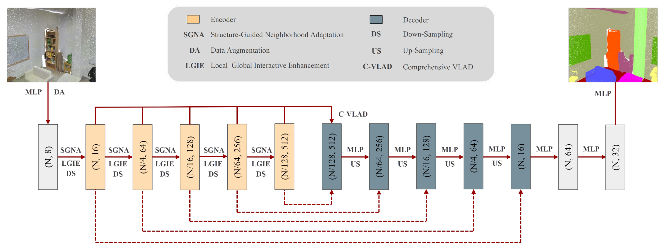
As illustrated in Figure 1, GFE-Net employs a five-stage hierarchical encoder–decoder. Each encoder stage contains the proposed SGNA block followed by LGIE, using updated designations that replace the previous HGFA and DRB labels to clarify that no external backbone is involved. Random subsampling reduces the point resolution from N to N/4, N/16, N/64, and N/128, while the feature dimension increases from 16 to 64, 128, 256, and 512. C-VLAD bridges the encoder and decoder, and nearest-neighbor interpolation with lateral skip fusion restores the original resolution prior to per-point classification.

2.2. Structure-Guided Neighborhood Adaptation Module

Conventional local feature aggregation modules encode neighborhood context by projecting feature differentials into high-dimensional embedding spaces. For outdoor point clouds acquired over urban terrain, points tend to be distributed relatively uniformly in the horizontal plane but exhibit pronounced vertical stratification—building facades and rooftop surfaces display smooth elevation gradients, whereas vegetation and ground regions present erratic vertical profiles. Leveraging these geometric regularities, the SGNA module introduces hierarchical shape descriptors alongside elevation difference statistics to guide adaptive neighborhood weighting, substantially improving aggregation fidelity in density-heterogeneous regions.
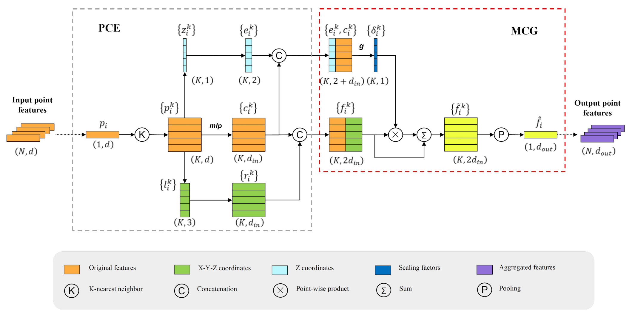
As depicted in Figure 2, the SGNA module integrates PCE units for positional context encoding and MCG units for morphology-driven contextual gating, culminating in an adaptively aggregated feature representation.

2.2.1. Positional Context Encoding Unit

At each encoder stage, the PCE unit first subsamples the input point cloud and constructs KNN neighborhoods for each surviving point. Following standard KNN edge-feature construction [18,34], neighborhood context is encoded from the feature and coordinate residuals between each query point and its neighbors. Given the input feature matrix P, each point p i P carries a d-dimensional attribute vector, and P i = { p i 1 , p i 2 , , p i K } denotes its Euclidean KNN set. The feature contrast is c i k = MLP ( p i p i k ) , and the geometric offset is r i k = MLP ( l i l i k ) , where l i R 3 is the XYZ coordinate of p i . Shared MLPs project both terms to d i n -dimensional vectors, and the combined neighborhood descriptor is
f i k = c i k r i k
The local descriptor set F i = { f i 1 , f i 2 , , f i K } is subsequently forwarded to the MCG unit for adaptive neighbor-wise gating.

2.2.2. Morphology-Driven Contextual Gating Unit

The MCG unit assigns a morphology-conditioned scalar gate to each of the K neighbors. The gate vector is therefore defined over the neighbor dimension rather than over feature channels. Each scalar is broadcast across the channels of the corresponding neighbor representation prior to pooling, so structurally consistent neighbors are emphasized and anomalous or cross-boundary neighbors are suppressed.
For query point i, let E i R K × 2 collect the relative and absolute elevation descriptors of its K neighbors, and let C i R K × d in contain the associated feature contrasts. The shared mapping h ( · ) is applied row-wise to E i C i , and softmax normalization is performed across the K neighbors:
γ i = Softmax K ( h ( E i C i ) ) R K
Here, γ i = [ γ i 1 , , γ i K ] T , and γ k is a scalar gate for the k-th neighbor. It is broadcast along the 2 d in feature channels before multiplication. Hence, MCG performs neighbor-wise morphological calibration rather than channel-wise gating. With a residual bypass, the gated feature matrix F ˜ i R K × 2 d in is
F ˜ i = ( ( 1 K + γ i ) · 1 2 d in T ) F i
The gated set F ˜ i = { f ˜ i 1 , . . . , f ˜ i K } is then routed through a joint pooling block combining attentive pooling (for weighted selection of salient neighbors) with max-pooling (for extracting dominant activations), yielding the aggregated query-level feature f ^ i R d o u t :
f ^ i = MLP ap ( F ˜ i ) max ( F ˜ i )
where ap ( · ) and max ( · ) denote attentive and max-pooling, respectively. The MCG unit produces a d o u t = 2 d i n -dimensional feature embedding. Crucially, the morphology-conditioned neighbor gates, their channel-wise broadcasting, and the residual calibration in Equations (2)–(4) are formulations introduced in this work.

2.3. Local–Global Interactive Enhancement Module

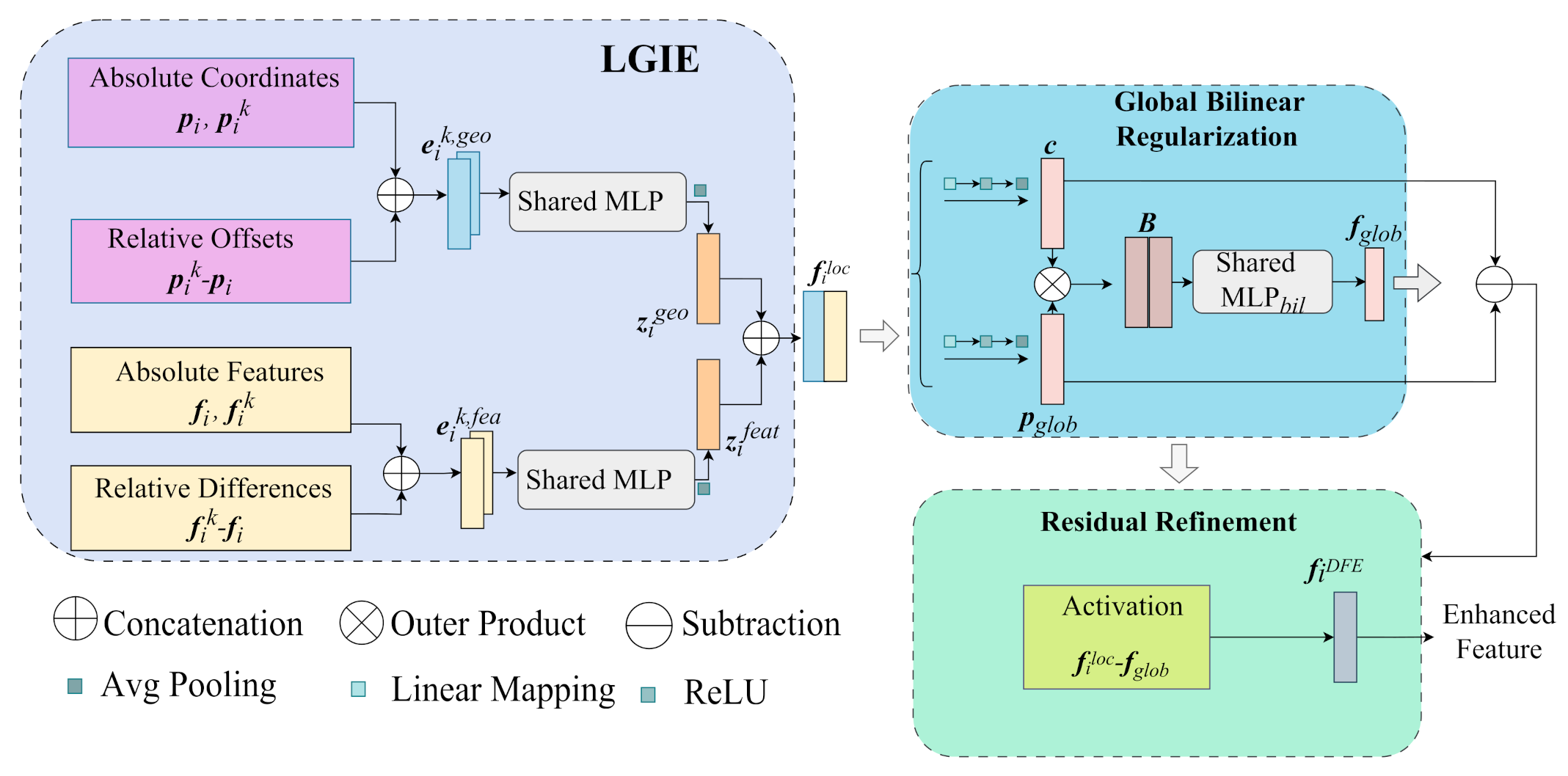
For unstructured point-cloud data, a multi-branch processing strategy is adopted to enable the network to simultaneously capture fine-grained local topology and holistic scene-wide co-activation patterns. Its detailed architecture is shown in Figure 3.
To extract local spatial structure in Euclidean space, we adopt the standard dynamic edge-feature construction used in graph-based point-cloud learning [34]. KNN constructs directed edges from each query point p i to its neighbors, forming p ˜ i = [ p i ; p i k p i ] , which encodes absolute coordinates and relative displacements. Aggregating all points gives P ˜ = [ p ˜ 1 ; ; p ˜ n ] , which is processed by a shared MLP and max-pooling over K neighbors:
P ˙ = max k MLP ( P ˜ )
A parallel feature-space graph is constructed using the same edge-feature principle [34]. Centering on f i in the C-dimensional embedding gives f ˜ i = [ f i ; f i k f i ] , and the full feature graph is F ˜ = [ f ˜ 1 ; ; f ˜ n ] . Following the same pooling procedure,
F ˙ = max k MLP ( F ˜ )
A supplementary shared MLP encodes the feature graph, and the local geometric context P ˙ is concatenated with the local feature context F ˙ to form the fused local descriptor:
F L = P ˙ F ˙
The local fusion block is resolution-agnostic and can be inserted into arbitrary stages of a CNN backbone without architectural modification.
Beyond local modeling, a scene-wide co-activation block uses holistic cues from the entire point set. Its outer-product interaction follows the general bilinear-pooling principle [46], while the low-dimensional treatment is motivated by compact bilinear representations [47]. Unlike quadratic self-attention, the proposed LGIE module derives compact channel and spatial descriptors before their bilinear interaction.
The global channel descriptor g o is obtained by first applying a linear projection W C to F L , activating with ReLU to enforce non-negativity, and then averaging over the N spatial positions:
g o = Avg N ReLU ( F L W C )
A reduction factor r 2 compresses the channel dimension, yielding g o = [ μ 1 , , μ c / r ] , where μ j captures the global average activation of channel j.
Symmetrically, a spatial descriptor g p is produced via a distinct weight matrix W p and channel-dimension average pooling:
g p = Avg c / r ReLU ( F L W p )
with g p = [ λ 1 , , λ N ] , where λ i reflects the mean activation of point i across the compressed feature map. The outer product of g p and g o , square-rooted for low-rank approximation, yields the global bilinear response:
G = g p g o
Using shared MLPs and dual residual connections, the network restores channel dimensionality and assembles the scene-wide perception map:
F G = MLP ( F L W p + G + F L W C )
To further purify the global representation, F G is subtracted from F L in a residual-filtering operation, suppressing redundant global components. A nonlinear activation σ is applied to improve representational capacity:
F out = σ ( F L F G )

2.4. Neighborhood Prediction Consistency Loss

To sharpen label assignment at semantically ambiguous interfaces between urban objects, GFE-Net incorporates a Neighborhood Prediction Consistency (NPC) regularization term into the overall training objective. For each query point p i and its neighborhood N i = p i 1 , p i 2 , , p i k , a binary disagreement indicator ω i k is defined as ω i k = 1 when the predicted semantic label of the k-th neighbor p i k differs from that of p i , and ω i k = 0 otherwise.
To account explicitly for spatial proximity, we adopt the standard Gaussian edge-weighting form [48] to define the distance decay. The disagreement indicator and its integration into the NPC regularizer are introduced in this work:
L N P C ( i ) = 1 K k = 1 K ω i k e x p x i x i k 2 2 2 σ 2
where x i R 3 and x i k R 3 are the normalized coordinates of the query point and its k-th neighbor. We use K = 16 and σ = 1.0 for all experiments. The Gaussian kernel decreases monotonically with squared Euclidean distance, so closer disagreements receive larger weights while distant disagreements are down-weighted.
This design follows the spatial proximity principle that nearby points are statistically more likely to share the same semantic label. At the same time, the Gaussian decay limits the influence of distant neighbors and reduces excessive consistency regularization across genuine object boundaries.
The complete training objective is formulated as follows:
L t o t a l = L W C E + 1 N e e = 1 N e L c o n s ( e ) + 1 N i = 1 N L N P C ( i )
where N e = 5 denotes the number of encoder stages and N = 40,960 is the number of full-resolution query points. The weighted cross-entropy and inter-layer constraint terms follow [15], whereas the NPC term in Equations (13) and (14) is proposed in this work.

2.5. Algorithmic Summary of Training and Inference

For clarity and reproducibility, Algorithm 1 summarizes the complete forward pass and explicitly separates the operations used during training from those retained at inference.
Generative AI tools were used exclusively for language polishing. No AI tools were involved in the study design, experiments, or data interpretation.
Algorithm 1 Forward Pass, Training, and Inference of GFE-Net.
Input: L 0 R N × 3 point coordinates, A 0 R N × d point attributes, ground-truth labels Y (training only), neighborhood size K = 16 , and five target resolutions { N , N / 4 , N / 16 , N / 64 , N / 128 } .
Output: P point-wise class probabilities, y ^ predicted labels, and learned parameters θ after training.
StepOperation
1Input Pre-Processing: Concatenate coordinates and attributes; apply stochastic data augmentation only during training, and obtain the initial embedding:
X 0 = MLP ( [ L 0 ; A 0 ] )
2Hierarchical Encoding: For s = 1 , , 5 , randomly subsample to the target resolution, construct KNN neighborhoods, apply SGNA and LGIE, and retain the output as a skip feature. The first downsampling operation, DS ( 1 ) , is the identity mapping.
( L s , X s ) = DS ( s ; L s 1 , X s 1 ) ; H s = SGNA ( s ; L s , X s ) E s = LGIE ( s ; H s ) ; S s = E s
3C-VLAD Bridge: Aggregate the multi-resolution encoder features into a compact scene descriptor and initialize the decoder bottleneck:
G = C VLAD ( { E s } s = 1 5 ) ; D 5 = Fuse ( G , E 5 )
4Hierarchical Decoding: For s = 5 , , 1 , use nearest-neighbor interpolation and fuse the corresponding encoder skip feature:
U s 1 = InterpNN ( D s , L s 1 ) D s 1 = MLP ( [ U s 1 ; S s 1 ] ) , S 0 = X 0
5Per-Point Prediction: Apply three fully connected layers (with dropout during training), followed by softmax:
Z = FC 3 ( FC 2 ( FC 1 ( D 0 ) ) ) ; P = softmax ( Z ) y ^ i = arg max { P i 1 , , P i C }
6Training Loss: Compute the weighted cross-entropy loss, the inter-layer constraint loss, and the NPC loss in Equation (13); combine them according to Equation (14). The fixed NPC settings are N e = 5 , N = 40 , 960 , K = 16 , and σ = 1.0 in normalized coordinate space.
L ( total ) = L ( WCE ) + Avg n [ L ( cons , n ) ] + Avg i [ L ( npc , i ) ]
7Parameter Update: During training, backpropagate the total loss and update all learnable parameters using Adam; repeat for 100 epochs with an initial learning rate of 0.01.
θ Adam ( θ , θ L ( total ) )
8Inference: Disable stochastic augmentation and dropout, execute Steps 1–5, omit loss computation and parameter updates, and return:
y ^ = { arg max { P i 1 , , P i C } } i = 1 N

3. Results

GFE-Net was evaluated on two publicly available large-scale benchmarks. Unless otherwise stated, model training and accuracy evaluation used TensorFlow on an NVIDIA RTX 4090 GPU. The efficiency profiling in Section 4.2 is a separate controlled experiment performed for every compared model on one NVIDIA RTX 3090 GPU with an Intel i9-12900K CPU. For NPC training, the number of encoder stages was N e = 5 , the full-resolution query count was N = 40,960, the KNN neighborhood size was K = 16 , and σ = 1.0 after centering and unit-range normalization of the coordinates. These values were fixed for both datasets. Training used Adam for 100 epochs with an initial learning rate of 0.01; batch size was dataset-dependent.

3.1. Benchmark Datasets

3.1.1. S3DIS Dataset

S3DIS (Stanford Large-Scale 3D Indoor Spaces Dataset) [49] is a widely adopted benchmark for indoor 3D point cloud semantic segmentation. It comprises over 200 million annotated LiDAR points from six buildings (split into six areas) and 271 indoor rooms, covering 13 typical semantic categories including structural objects (ceiling, floor, wall), architectural components, furniture, and clutter. Following the standard academic protocol, all models are evaluated via 6-fold cross-validation on this dataset, with overall accuracy (OA), mean accuracy (mAcc), and mean Intersection over Union (mIoU) as the core quantitative metrics. This dataset features uneven point density, blurred inter-class boundaries, and class imbalance, making it a representative and challenging benchmark for validating segmentation robustness in complex indoor scenes.

3.1.2. SensatUrban Dataset

The SensatUrban [45] dataset encompasses urban districts of Birmingham and Cambridge, UK, acquired via UAV photogrammetry and comprising nearly 3 billion 3D points partitioned into 43 tiles. Training employs 10 Birmingham and 20 Cambridge tiles; validation uses 2 and 4 tiles, while testing uses 2 and 5 tiles, respectively. The point density is approximately 372 pts/m2, and 13 semantic categories are annotated. Batch size B = 6 ; XYZ coordinates and RGB color channels serve as input features.

3.2. Evaluation Protocol

Quantitative assessment employed overall accuracy (OA), per-class Intersection over Union (IoU), mean IoU (mIoU), and mean class accuracy (mAcc):
OA = i = 1 n T P i i = 1 n T P i + T N i + F P i + F N i
IoU = T P i T P i + F P i + F N i
mIoU = 1 n i = 1 n IoU i
mAcc = 1 n i = 1 n T P i T P i + F N i
where T P i , T N i , F P i , and F N i are the true-positive, true-negative, false-positive, and false-negative counts for class i, and n is the number of semantic classes. In Equation (18), mAcc denotes the arithmetic mean of the per-class recall T P i / ( T P i + F N i ) .

3.3. Semantic Segmentation Results

3.3.1. Results on S3DIS Dataset

On the S3DIS indoor point-cloud dataset, Table 1 reports that the proposed GFE-Net achieves 89.6% OA, 83.5% mAcc, and 73.1% mIoU under the S3DIS six-fold cross-validation protocol. It outperforms Point Transformer by 0.6, 1.5, and 1.1 percentage points, respectively, and performs comparably to PointNeXt. Although PTv3 achieves the highest overall performance, GFE-Net obtains a higher IoU for clutter (63.9% versus 55.0%), demonstrating its effectiveness for geometrically irregular categories. Notably, GFE-Net is primarily tailored for large-scale outdoor remote-sensing scenarios, whereas PTv3 is better optimized for fine-grained indoor environments, which accounts for its higher overall metrics on the indoor S3DIS benchmark.
For structural categories (ceiling, floor, wall), GFE-Net achieves IoU scores of 96.3%, 98.9%, and 85.2% through SGNA, whose MCG unit enhances coherent neighbors while suppressing outliers in density-heterogeneous regions. For fine-grained objects (chair, table, bookcase), LGIE integrates Euclidean topology with global bilinear patterns, yielding IoUs of 84.2%, 75.3%, and 67.4%. For boundary-sensitive classes (board, clutter, door), the NPC loss enforces spatial consistency through Gaussian distance-decay weighting, raising the IoUs to 69.5%, 63.9%, and 74.1%.
Recent Mamba-based results are discussed separately because their published S3DIS evaluations use the Area-5 protocol rather than six-fold cross-validation. PCM reports 79.6% mIoU with an additional DeLA local extractor [50], whereas Serialized Point Mamba reports 70.6% mIoU [51]. These values provide contemporary context but are not mixed with Table 1 because the protocols are not directly comparable.
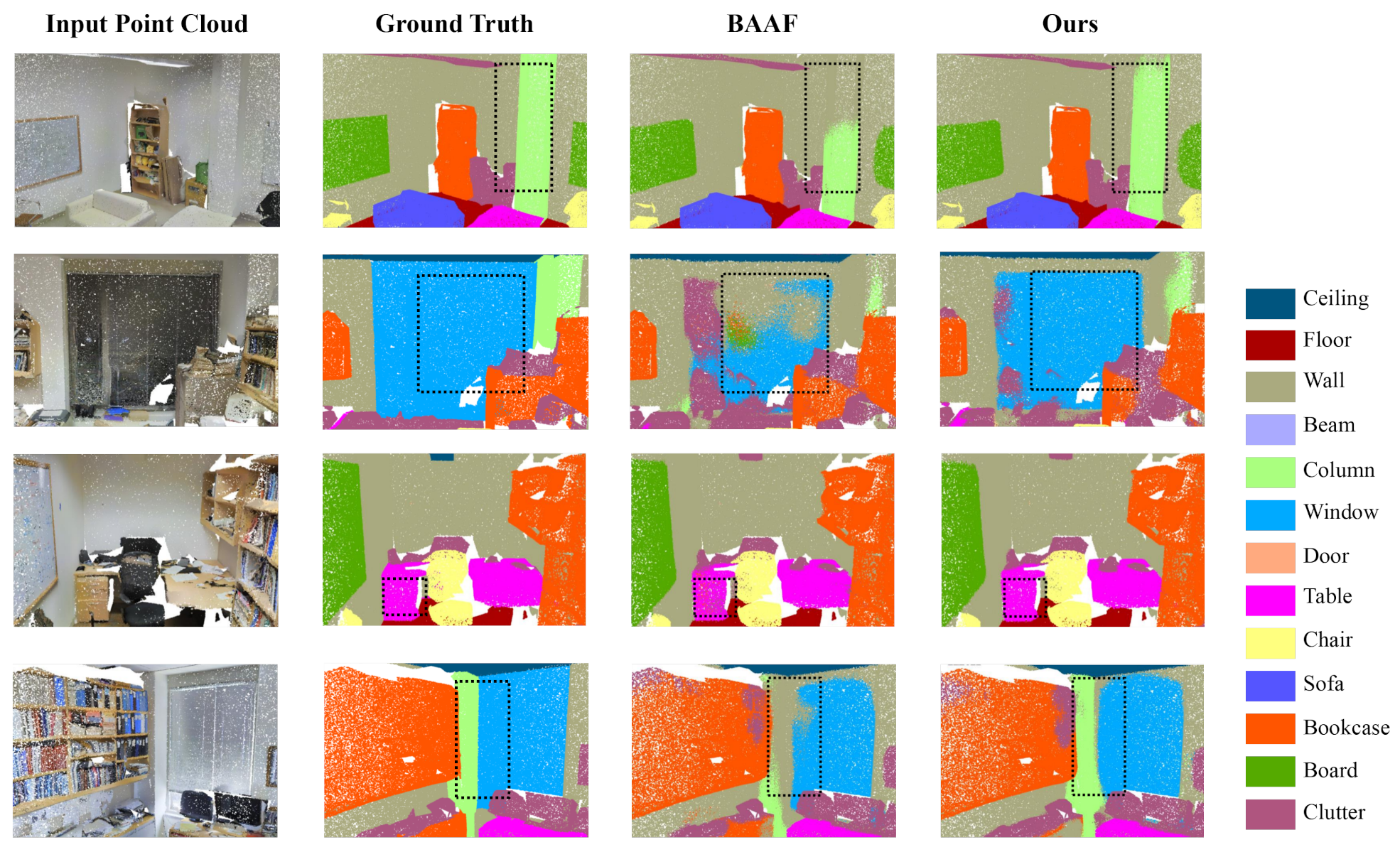
Figure 4 visualizes representative segmentation results on the S3DIS dataset. GFE-Net is primarily designed for large-scale remote-sensing point clouds. Its competitive performance on both indoor S3DIS and UAV-photogrammetric SensatUrban demonstrates cross-domain generalization. This robustness benefits from SGNA, which mitigates density variation through morphology-conditioned neighbor weighting; LGIE, which integrates local geometry with global context; and the NPC loss, which improves prediction consistency near semantic boundaries. GFE-Net validates that the geometry-enhanced feature extraction framework effectively addresses the core challenges of ambiguous class transitions, irregular sampling density, and overlapping geometric features in 3D point-cloud semantic segmentation.

3.3.2. Results on SensatUrban Dataset

On the SensatUrban urban point-cloud dataset, Table 2 shows that the proposed GFE-Net achieves 93.3% OA and 61.1% mIoU, substantially outperforming PTv (54.0%) and PTv2 (57.4%) by 7.1 and 3.7 percentage points in mIoU, respectively, while performing comparably to LACV-Net (61.4%). These results demonstrate that structure-conditioned neighbor weighting, local–global feature interaction, and spatial consistency regularization provide complementary improvements in geometric representation, contextual modeling, and boundary precision.
Although slightly below LACV-Net in overall mIoU, GFE-Net attains higher per-class IoU in most categories. For core urban structures (ground, vegetation, building), SGNA raises IoU to 85.2%, 98.6%, and 96.2%, with the building IoU improved by 1.2 points over LACV-Net through MCG-driven density and structural adaptation. For medium-difficulty classes (wall, bridge, parking), LGIE achieves 64.2%, 65.9%, and 62.1% IoU by fusing Euclidean topology with global bilinear patterns, outperforming PTv and PTv2. For boundary-sensitive categories (traffic road, bike), NPC yields the best IoUs (62.8%, 6.3%) via Gaussian-weighted consistency enforcement, suppressing prediction noise on small or blurred targets.
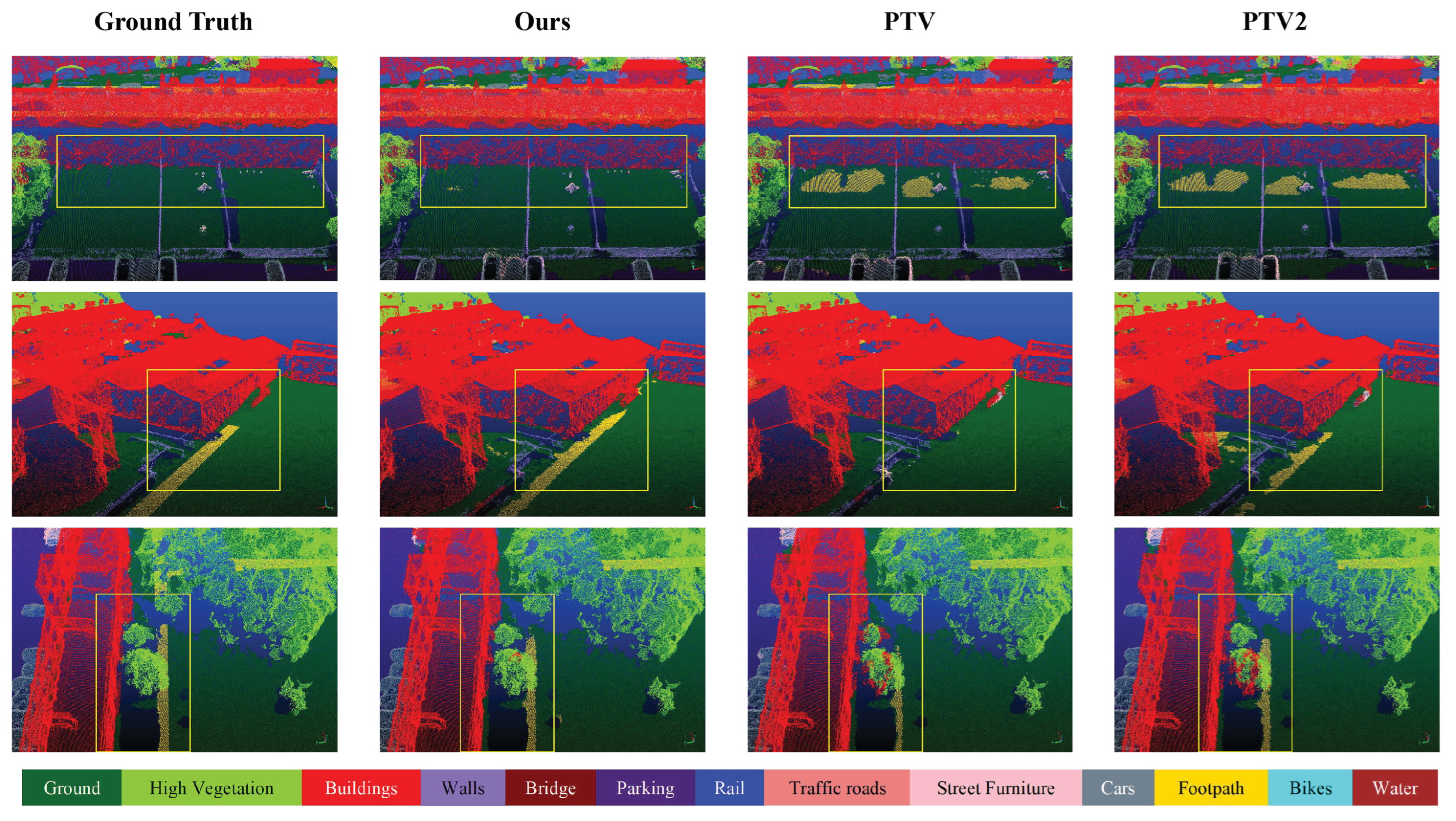
Figure 5 visualizes representative segmentation results on the SensatUrban dataset, validating that its geometry-enhanced feature extraction framework (SGNA + LGIE + NPC) effectively addresses core challenges in urban point-cloud labeling, including density heterogeneity, inter-class feature overlap, and blurred semantic boundaries.

4. Discussion

Ablation experiments were conducted on the SensatUrban validation and test splits to isolate the contribution of each proposed component. All ablation configurations shared identical hardware, hyperparameters, and loss settings to ensure fair comparison at 4096 input points.

4.1. Ablation Studies

4.1.1. Ablation of SGNA Module

To verify the effectiveness of the proposed SGNA module in addressing the shortcomings of fixed-neighborhood queries in density-heterogeneous regions, nine feature aggregation configurations (A1–A9) were designed for ablation comparison, with quantitative results listed in Table 3. A1 (basic local feature aggregation, LFA) served as the baseline model, achieving an OA of 91.8% and mIoU of 58.4% via simple neighborhood pooling, lacking geometric guidance and adaptive weighting mechanisms. A2 augments the baseline solely with the PCE unit—encoding absolute point coordinates together with relative spatial offsets to enrich the neighborhood descriptor—while still excluding the MCG unit, raising OA to 92.6% and mIoU to 59.9% (a 1.5% gain over A1). This isolated improvement verifies that explicit positional context encoding alone already supplies useful geometric priors for neighborhood aggregation, yet without morphology-conditioned neighbor-wise gating the network cannot adaptively suppress structurally inconsistent neighbors, leaving a clear performance margin relative to the complete SGNA variants (A5–A9) and motivating the introduction of the MCG unit. A3 removes the core MCG unit, and the resulting mIoU drop to 57.8% confirms that the MCG unit—synthesizing class-discriminative weighting vectors through hierarchical shape descriptors and elevation difference statistics—plays a pivotal role in suppressing outliers and cross-class contamination in unevenly sampled regions. A4 replaces the MCG unit with scalar self-attentive pooling, recovering mIoU to 60.5% but still trailing most SGNA variants, confirming that structure-conditioned neighbor weighting is more effective than generic self-attentive pooling for density-heterogeneous point clouds. Among the complete SGNA variants (A5–A9), a clear performance gradient is observed: A5 (elevation-only MCG) and A7 (single KNN neighborhood search) both reach 60.7% mIoU, while A8 (single radius neighborhood search) scores 60.2% mIoU, demonstrating the superiority of KNN search in capturing fine-grained local structural features; A6, integrating elevation and hierarchical shape feature fusion, achieves 60.9% mIoU; and A9, adopting the fused KNN+radius complementary neighborhood strategy, attains optimal performance of 93.3% OA and 61.1% mIoU—2.7 percentage points above the baseline A1. This fully demonstrates that the structure-guided design of SGNA can effectively mine robust local features, resolving the bottleneck of fixed-neighborhood queries in complex outdoor scenes.

4.1.2. Ablation of LGIE Module

To verify the role of the LGIE module in enriching semantic representation and inter-class separability, six structural configurations (B1–B6) were ablated, with the results shown in Table 4. B1 (the baseline model without LGIE module) obtained the worst performance of 91.6% OA and 58.3% mIoU, as it relies solely on single-branch feature extraction and fails to capture both local details and scene-wide context. Progressively adding LGIE components brings steady performance improvement: B2, equipped with only the local spatial branch (extracting Euclidean neighborhood topology), achieves 92.2% OA and 59.4% mIoU; B3, integrating local and global branches without feature refinement, boosts mIoU to 60.0%; B4, replacing average pooling with max-pooling, scores 60.3% mIoU; and B5, removing the low-rank square-root approximation, achieves 59.8% mIoU—both lower than the full LGIE configuration, validating the rationality of average pooling and Gaussian low-rank bilinear interaction design in the LGIE module. Finally, B6 (the complete LGIE module) achieves the optimal 93.3% OA and 61.1% mIoU, confirming that jointly exploiting precise local spatial topology and holistic bilinear co-activation patterns in the latent feature space can effectively elevate feature discriminative power, alleviate the problem of overlapping geometric features between categories, and significantly boost semantic segmentation performance.

4.1.3. Ablation of NPC Loss

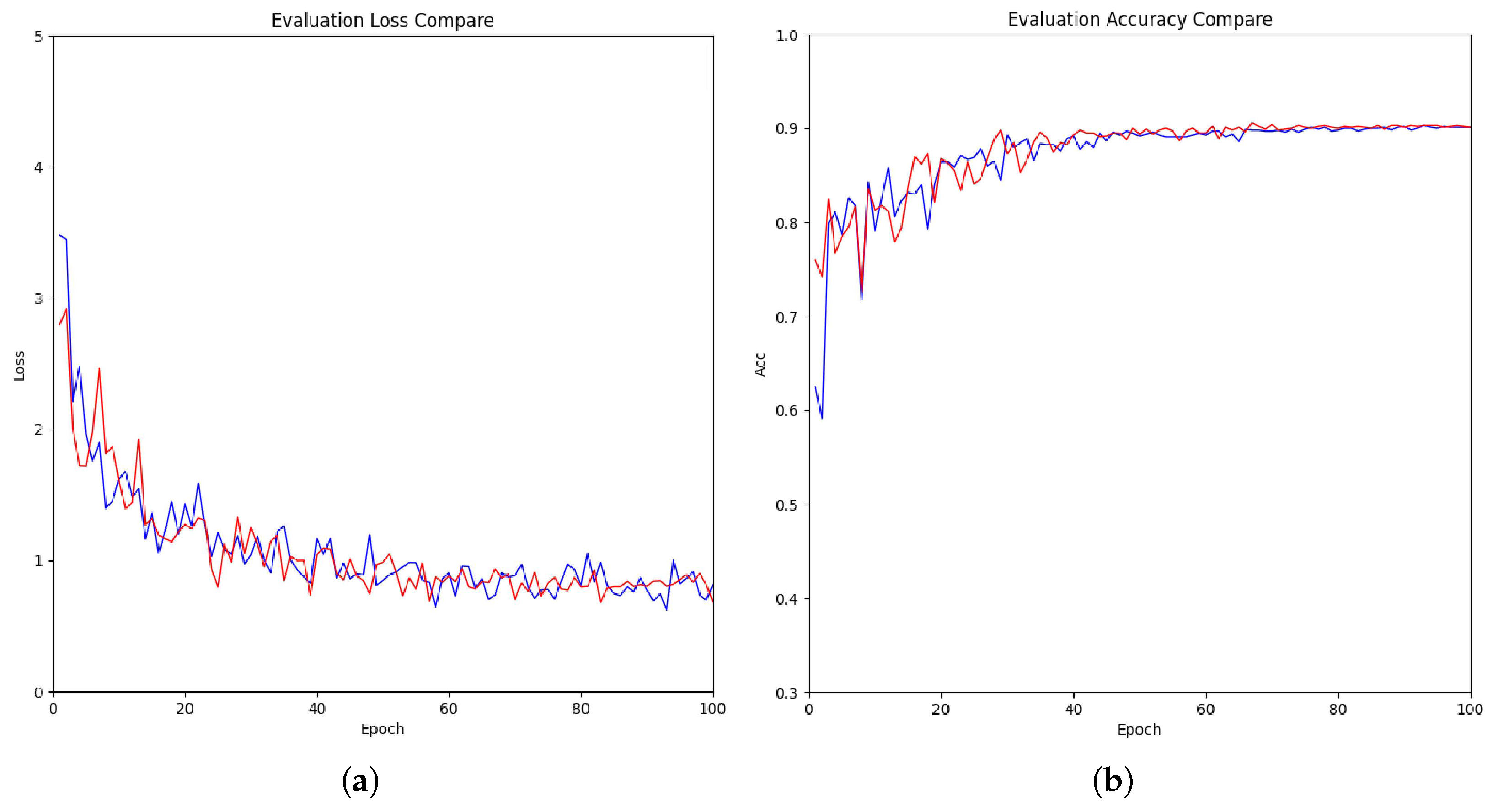
To verify the effect of the NPC loss in sharpening semantic boundaries and reducing interface prediction noise, six loss function configurations (C1–C6) were tested, with quantitative results presented in Table 5. C1 denotes the complete network architecture trained only with the basic semantic segmentation loss, where the NPC regularization term is removed. This setting obtains 92.0% OA and 58.9% mIoU, indicating that although the structural modules provide effective feature representation, the model still suffers from label confusion and fuzzy boundaries at object interfaces due to the absence of spatial proximity constraints. As the NPC regularization based on Gaussian distance-decay weighting is progressively introduced, model performance improves continuously: C2 achieves 92.4% OA and 59.6% mIoU, while C3 rises to 92.9% OA and 60.4% mIoU. C4 replaces the Gaussian distance-decay weighting kernel with an inverse-distance weighting scheme, achieving 93.1% OA and 60.8% mIoU; although this configuration likewise imposes stronger penalties on closer neighbor mismatches, its slow weight decay fails to sufficiently differentiate near-range from far-range conflicts, yielding a 0.3-percentage-point mIoU gap relative to the full NPC loss. C5 further substitutes a uniform (distance-agnostic) weighting strategy, which treats all neighbor disagreements equally regardless of geometric proximity, resulting in a noticeable performance regression to 92.7% OA and 60.1% mIoU. The 1.0-percentage-point mIoU drop from C6 to C5 directly validates the necessity of distance-aware weighting: without modulating penalties by spatial proximity, the loss cannot exploit the proximity principle that geometrically close points are statistically more likely to share a semantic label, thereby weakening boundary regularization. The performance gradient C1 (without NPC) → C2/C3 (progressive NPC regularization) → C5 (uniform) → C4 (inverse-distance) → C6 (Gaussian) further confirms that the Gaussian distance-decay kernel offers the most appropriate balance between near-range sensitivity and far-range tolerance, making it the optimal choice for the NPC loss formulation. C6, equipped with the full NPC loss, reaches the optimal 93.3% OA and 61.1% mIoU. The NPC loss penalizes label mismatches between query points and their proximate neighbors according to geometric proximity, compelling spatially consistent predictions and effectively eliminating prediction noise at semantic interfaces. The performance improvement is particularly prominent in boundary-blurred and small-sample categories such as rail, bridge, and bike, whose IoU scores are significantly higher than the baseline C1. This fully demonstrates that the NPC loss can effectively overcome the core challenge of ambiguous class transitions in large-scale outdoor LiDAR point-cloud segmentation. Figure 6 illustrates the training dynamics with and without the NPC loss. As shown in Figure 6a, the loss curve of the complete loss function converges to a lower value than that of the aggregated loss alone, indicating that NPC regularization facilitates optimization rather than hindering it. Figure 6b further shows that the overall accuracy of the model with the NPC loss converges to a higher plateau, confirming that the NPC loss effectively improves segmentation performance while maintaining stable training convergence.

4.1.4. Ablation of Inter-Module Collaboration

As shown in Table 6, the full model achieves the best performance, with 93.3% OA and 61.1% mIoU. Removing both SGNA and LGIE causes the largest degradation, reducing OA and mIoU by 3.4 and 5.9 percentage points, respectively. This indicates that morphology-aware neighborhood aggregation and local–global feature interaction are both important for discriminative feature representation. Removing SGNA and NPC results in 90.3% OA and 55.9% mIoU, while removing LGIE and NPC yields 90.1% OA and 55.7% mIoU. Retaining LGIE yields comparatively better performance, suggesting that local–global contextual interaction provides strong independent representational capability. Nevertheless, all dual-removal configurations perform substantially worse than the full model, demonstrating that SGNA, LGIE, and NPC provide complementary improvements in geometric representation, contextual modeling, and spatial prediction consistency.

4.2. Efficiency Analysis

As shown in Table 7, among all models, GFE-Net has 161.1 M parameters, 0.590 GFLOPs, and a per-epoch training time of 70.1 s, slightly higher than the 66.4 s required by LACV-Net. Meanwhile, GFE-Net exhibits notable efficiency advantages over heavyweight models such as PTv and PTv2: its parameter count is reduced by 1.6 M and 14.2 M, respectively; GFLOPs are lowered by 0.043 and 0.120, respectively; and per-epoch training time is shortened by 12.4 s and 21.1 s, respectively. RandLA-Net remains the most lightweight baseline due to its minimalist design and reliance on random sampling.
On SensatUrban, GFE-Net achieves OA/mIoU of 93.3%/61.1%: compared with RandLA-Net, the gains are 0.9/1.7 percentage points; compared with PTv and PTv2, the gains are 2.0/7.1 and 0.8/3.7 percentage points, respectively. Relative to LACV-Net, GFE-Net improves OA by 0.1 percentage points but is 0.3 percentage points lower in mIoU. These results quantitatively characterize the accuracy–efficiency trade-off, supporting the practical deployment of GFE-Net in large-scale outdoor LiDAR point-cloud parsing tasks.

5. Conclusions

This paper presents GFE-Net, a Geometry-Enhanced Feature Extraction Network for semantic segmentation of large-scale urban LiDAR point clouds. The SGNA module, incorporating the MCG unit, delivers morphology-aware, density-robust neighborhood aggregation via structure-conditioned neighbor-wise gating. The LGIE module enriches feature representations by jointly processing local Euclidean structure and scene-wide bilinear co-activation patterns through two parallel branches. The NPC loss enforces spatially consistent prediction assignment at object interfaces via a theoretically motivated Gaussian distance-decay weighting kernel.
Experiments on S3DIS and SensatUrban yielded 89.6%/73.1% and 93.3%/61.1% OA/mIoU, respectively. Comparative evaluations demonstrated that GFE-Net achieves competitive performance across both indoor and large-scale urban scenarios, despite not attaining the highest mIoU under certain S3DIS evaluation protocols. Ablation studies quantified the individual contributions of each component, while efficiency profiling provided explicit trade-offs in parameters, GFLOPs, and runtime, offering a clear basis for practical deployment.
Collectively, the SGNA, LGIE, and NPC loss components synergistically advance the network’s capacity to model fine-grained local morphology and broader scene context, delivering semantically coherent and boundary-precise three-dimensional understanding. Future work will explore extending the proposed components to scene flow estimation, instance-level labeling, and multi-modal fusion with RGB imagery.


Author Contributions

Conceptualization, H.L. and G.Z.; Materials and Methods, H.L.; Validation, H.L. Writing—Original Draft Preparation, H.L.; Writing—Review and Editing, C.C. and Z.S.; Visualization, H.L.; Supervision and Project Administration, G.Z. All authors have read and agreed to the published version of the manuscript.

Funding

This research was partially funded by the National Natural Science Foundation of China under Grant 62303217, and by the Natural Science Foundation of the Jiangsu Higher Education Institutions of China, grant number 1020241708.

Data Availability Statement

The datasets generated and analyzed during the current study are publicly available from the sources cited as Refs. [45,49].

Acknowledgments

We thank the editors and anonymous reviewers for their constructive comments and suggestions. We acknowledge the use of ChatGPT (OpenAI, San Francisco, CA, USA; version GPT-4, 2024) for English language polishing and stylistic refinement during manuscript preparation.

Conflicts of Interest

The authors declare no conflicts of interest.

References

  1. Zhang, H.; Wang, C.; Tian, S.; Lu, B.; Zhang, L.; Ning, X.; Bai, X. Deep learning-based 3D point cloud classification: A systematic survey and outlook. Displays 2023, 79, 102456. [Google Scholar] [CrossRef] [Scilit]
  2. Cheng, Q.; Sun, P.; Yang, C.; Yang, Y.; Liu, P.X. A morphing-based 3D point cloud reconstruction framework for medical image processing. Comput. Methods Programs Biomed. 2020, 193, 105495. [Google Scholar] [CrossRef] [Scilit]
  3. Li, Y.; Bu, R.; Sun, M.; Wu, W.; Di, X.; Chen, B. PointCNN: Convolution on X-Transformed Points. In Proceedings of the Advances in Neural Information Processing Systems; Neural Information Processing Systems Foundation, Inc. (NeurIPS): San Diego, CA, USA, 2018; Volume 31. [Google Scholar]
  4. Kim, P.; Chen, J.; Cho, Y.K. SLAM-driven robotic mapping and registration of 3D point clouds. Autom. Constr. 2018, 89, 38–48. [Google Scholar] [CrossRef] [Scilit]
  5. Fan, S.; Dong, Q.; Zhu, F.; Lv, Y.; Ye, P.; Wang, F.Y. SCF-Net: Learning Spatial Contextual Features for Large-Scale Point Cloud Segmentation. In Proceedings of the 2021 IEEE/CVF Conference on Computer Vision and Pattern Recognition (CVPR); IEEE: Piscataway, NJ, USA, 2021; pp. 14499–14508. [Google Scholar] [CrossRef] [Scilit]
  6. Wang, X.; Zhang, Y.; Shao, R.; Chen, S.; Li, H.; Chen, X. SAT-Former: An Efficient 3-D Transformer with Semantic Aggregated Point Tokenizer for Point Cloud Semantic Segmentation in Urban Scenes. IEEE J. Sel. Top. Appl. Earth Obs. Remote Sens. 2025, 18, 28326–28342. [Google Scholar] [CrossRef] [Scilit]
  7. Xue, J.; Men, C.; Liu, Y.; Xiong, S. Adaptive neighbourhood recovery method for machine learning based 3D point cloud classification. Int. J. Remote Sens. 2023, 44, 311–340. [Google Scholar] [CrossRef] [Scilit]
  8. Li, H.; Liu, Y.; Men, C.; Fang, Y. A novel 3D point cloud segmentation algorithm based on multi-resolution supervoxel and MGS. Int. J. Remote Sens. 2021, 42, 8492–8525. [Google Scholar] [CrossRef] [Scilit]
  9. Li, Z.; Liu, F.; Yang, W.; Peng, S.; Zhou, J. A Survey of Convolutional Neural Networks: Analysis, Applications, and Prospects. IEEE Trans. Neural Netw. Learn. Syst. 2022, 33, 6999–7019. [Google Scholar] [CrossRef] [Scilit]
  10. Charles, R.Q.; Su, H.; Kaichun, M.; Guibas, L.J. PointNet: Deep Learning on Point Sets for 3D Classification and Segmentation. In Proceedings of the 2017 IEEE Conference on Computer Vision and Pattern Recognition (CVPR); IEEE: Piscataway, NJ, USA, 2017; pp. 77–85. [Google Scholar] [CrossRef] [Scilit]
  11. Hu, Q.; Yang, B.; Xie, L.; Rosa, S.; Guo, Y.; Wang, Z.; Trigoni, N.; Markham, A. RandLA-Net: Efficient Semantic Segmentation of Large-Scale Point Clouds. In Proceedings of the 2020 IEEE/CVF Conference on Computer Vision and Pattern Recognition (CVPR); IEEE: Piscataway, NJ, USA, 2020; pp. 11105–11114. [Google Scholar] [CrossRef] [Scilit]
  12. Li, D.; Shi, G.; Li, J.; Chen, Y.; Zhang, S.; Xiang, S.; Jin, S. PlantNet: A dual-function point cloud segmentation network for multiple plant species. ISPRS J. Photogramm. Remote Sens. 2022, 184, 243–263. [Google Scholar] [CrossRef] [Scilit]
  13. Jiang, T.; Yang, B.; Wang, Y.; Dai, L.; Qiu, B.; Liu, S.; Li, S.; Zhang, Q.; Jin, X.; Zeng, W. RailSeg: Learning Local–Global Feature Aggregation with Contextual Information for Railway Point Cloud Semantic Segmentation. IEEE Trans. Geosci. Remote Sens. 2023, 61, 1–29. [Google Scholar] [CrossRef] [Scilit]
  14. Yu, H.; Wang, Z.; Zhou, Q.; Ma, Y.; Wang, Z.; Liu, H.; Ran, C.; Wang, S.; Zhou, X.; Zhang, X. Deep-Learning-Based Semantic Segmentation Approach for Point Clouds of Extra-High-Voltage Transmission Lines. Remote Sens. 2023, 15, 2371. [Google Scholar] [CrossRef] [Scilit]
  15. Shuai, H.; Xu, X.; Liu, Q. Backward Attentive Fusing Network with Local Aggregation Classifier for 3D Point Cloud Semantic Segmentation. IEEE Trans. Image Process. 2021, 30, 4973–4984. [Google Scholar] [CrossRef] [Scilit]
  16. Su, Y.; Liu, W.; Yuan, Z.; Cheng, M.; Zhang, Z.; Shen, X.; Wang, C. DLA-Net: Learning dual local attention features for semantic segmentation of large-scale building facade point clouds. Pattern Recognit. 2022, 123, 108372. [Google Scholar] [CrossRef] [Scilit]
  17. Cramer, M. The DGPF-Test on Digital Airborne Camera Evaluation Overview and Test Design. Photogramm. Fernerkund. Geoinf. 2010, 2010, 73–82. [Google Scholar] [CrossRef] [Scilit]
  18. Peterson, L. K-nearest neighbor. Scholarpedia 2009, 4, 1883. [Google Scholar] [CrossRef] [Scilit]
  19. Zeng, Z.; Xu, Y.; Xie, Z.; Tang, W.; Wan, J.; Wu, W. Large-scale point cloud semantic segmentation via local perception and global descriptor vector. Expert Syst. Appl. 2024, 246, 123269. [Google Scholar] [CrossRef] [Scilit]
  20. Qi, C.R.; Yi, L.; Su, H.; Guibas, L.J. PointNet++: Deep Hierarchical Feature Learning on Point Sets in a Metric Space. In Proceedings of the Advances in Neural Information Processing Systems; Neural Information Processing Systems Foundation, Inc. (NeurIPS): San Diego, CA, USA, 2017; Volume 30. [Google Scholar]
  21. Thomas, H.; Qi, C.R.; Deschaud, J.E.; Marcotegui, B.; Goulette, F.; Guibas, L. KPConv: Flexible and Deformable Convolution for Point Clouds. In Proceedings of the 2019 IEEE/CVF International Conference on Computer Vision (ICCV); IEEE: Piscataway, NJ, USA, 2019; pp. 6410–6419. [Google Scholar] [CrossRef] [Scilit]
  22. Qian, G.; Li, Y.; Peng, H.; Mai, J.; Hammoud, H.; Elhoseiny, M.; Ghanem, B. PointNeXt: Revisiting PointNet++ with Improved Training and Scaling Strategies. In Proceedings of the Advances in Neural Information Processing Systems; Neural Information Processing Systems Foundation, Inc. (NeurIPS): San Diego, CA, USA, 2022; Volume 35, pp. 23192–23204. [Google Scholar] [CrossRef] [Scilit]
  23. Xu, Y.; Tang, W.; Zeng, Z.; Wu, W.; Wan, J.; Guo, H.; Xie, Z. NeiEA-NET: Semantic segmentation of large-scale point cloud scene via neighbor enhancement and aggregation. Int. J. Appl. Earth Obs. Geoinf. 2023, 119, 103285. [Google Scholar] [CrossRef] [Scilit]
  24. Aditya, A.; Lohani, B.; Aryal, J.; Winter, S. GreenSegNet: A Novel Deep Learning Architecture for Urban Vegetation Segmentation from MLS Data. IEEE Trans. Geosci. Remote Sens. 2024, 62, 4413210. [Google Scholar] [CrossRef] [Scilit]
  25. Simonovsky, M.; Komodakis, N. Dynamic edge-conditioned filters in convolutional neural networks on graphs. In Proceedings of the 2017 IEEE Conference on Computer Vision and Pattern Recognition (CVPR); IEEE: Piscataway, NJ, USA, 2017; pp. 29–38. [Google Scholar]
  26. Wang, Y.; Sun, Y.; Liu, Z.; Sarma, S.E.; Bronstein, M.M.; Solomon, J.M. Dynamic graph cnn for learning on point clouds. ACM Trans. Graph. (TOG) 2019, 38, 146. [Google Scholar] [CrossRef] [Scilit]
  27. Lu, Q.; Chen, C.; Xie, W.; Luo, Y. PointNGCNN: Deep convolutional networks on 3D point clouds with neighborhood graph filters. Comput. Graph. 2020, 86, 42–51. [Google Scholar] [CrossRef] [Scilit]
  28. Wei, M.; Wei, Z.; Zhou, H.; Hu, F.; Si, H.; Chen, Z.; Zhu, Z.; Qiu, J.; Yan, X.; Guo, Y.; et al. AGConv: Adaptive graph convolution on 3D point clouds. IEEE Trans. Pattern Anal. Mach. Intell. 2023, 45, 9374–9392. [Google Scholar] [CrossRef] [Scilit]
  29. Zhao, H.; Jiang, L.; Jia, J.; Torr, P.H.; Koltun, V. Point transformer. In Proceedings of the IEEE/CVF International Conference on Computer Vision; IEEE: Piscataway, NJ, USA, 2021; pp. 16259–16268. [Google Scholar]
  30. Wu, X.; Lao, Y.; Jiang, L.; Liu, X.; Zhao, H. Point transformer v2: Grouped vector attention and partition-based pooling. In Proceedings of the Advances in Neural Information Processing Systems; Neural Information Processing Systems Foundation, Inc. (NeurIPS): San Diego, CA, USA, 2022; Volume 35, pp. 33330–33342. [Google Scholar]
  31. Wu, X.; Jiang, L.; Wang, P.S.; Liu, Z.; Liu, X.; Qiao, Y.; Ouyang, W.; He, T.; Zhao, H. Point transformer v3: Simpler, faster, stronger. In Proceedings of the 2024 IEEE/CVF Conference on Computer Vision and Pattern Recognition (CVPR); IEEE: Piscataway, NJ, USA, 2024; pp. 4840–4851. [Google Scholar]
  32. Yang, Y.Q.; Guo, Y.X.; Xiong, J.Y.; Liu, Y.; Pan, H.; Wang, P.S.; Tong, X.; Guo, B. Swin3D: A pretrained transformer backbone for 3D indoor scene understanding. Comput. Vis. Media 2025, 11, 83–101. [Google Scholar] [CrossRef] [Scilit]
  33. Niu, Z.; Zhong, G.; Yu, H. A review on the attention mechanism of deep learning. Neurocomputing 2021, 452, 48–62. [Google Scholar] [CrossRef] [Scilit]
  34. Wang, L.; Huang, Y.; Hou, Y.; Zhang, S.; Shan, J. Graph Attention Convolution for Point Cloud Semantic Segmentation. In Proceedings of the 2019 IEEE/CVF Conference on Computer Vision and Pattern Recognition (CVPR); IEEE: Piscataway, NJ, USA, 2019; pp. 10288–10297. [Google Scholar] [CrossRef] [Scilit]
  35. Yang, J.; Zhang, Q.; Ni, B.; Li, L.; Liu, J.; Zhou, M.; Tian, Q. Modeling Point Clouds with Self-Attention and Gumbel Subset Sampling. In Proceedings of the 2019 IEEE/CVF Conference on Computer Vision and Pattern Recognition (CVPR); IEEE: Piscataway, NJ, USA, 2019; pp. 3318–3327. [Google Scholar] [CrossRef] [Scilit]
  36. Guo, M.H.; Cai, J.X.; Liu, Z.N.; Mu, T.J.; Martin, R.R.; Hu, S.M. PCT: Point cloud transformer. Comput. Vis. Media 2021, 7, 187–199. [Google Scholar] [CrossRef] [Scilit]
  37. Yu, X.; Tang, L.; Rao, Y.; Huang, T.; Zhou, J.; Lu, J. Point-BERT: Pre-Training 3D Point Cloud Transformers with Masked Point Modeling. In Proceedings of the 2022 IEEE/CVF Conference on Computer Vision and Pattern Recognition (CVPR); IEEE: Piscataway, NJ, USA, 2022; pp. 19291–19300. [Google Scholar] [CrossRef] [Scilit]
  38. Geng, X.; Ji, S.; Lu, M.; Zhao, L. Multi-Scale Attentive Aggregation for LiDAR Point Cloud Segmentation. Remote Sens. 2021, 13, 691. [Google Scholar] [CrossRef] [Scilit]
  39. Zhao, L.; Xu, S.; Liu, L.; Ming, D.; Tao, W. SVASeg: Sparse voxel-based attention for 3D LiDAR point cloud semantic segmentation. Remote Sens. 2022, 14, 4471. [Google Scholar] [CrossRef] [Scilit]
  40. Wang, J.; Li, H.; Xu, Z.; Xie, X. Semantic segmentation of urban airborne LiDAR point clouds based on fusion attention mechanism and multi-scale features. Remote Sens. 2023, 15, 5248. [Google Scholar] [CrossRef] [Scilit]
  41. Liang, Z.; Lai, X. Multilevel geometric feature embedding in transformer network for ALS point cloud semantic segmentation. Remote Sens. 2024, 16, 3386. [Google Scholar] [CrossRef] [Scilit]
  42. Engelmann, F.; Kontogianni, T.; Hermans, A.; Leibe, B. Exploring Spatial Context for 3D Semantic Segmentation of Point Clouds. In Proceedings of the 2017 IEEE International Conference on Computer Vision Workshops (ICCVW); IEEE: Piscataway, NJ, USA, 2017; pp. 716–724. [Google Scholar] [CrossRef] [Scilit]
  43. Nurunnabi, A.; Teferle, F.N.; Li, J.; Lindenbergh, R.C.; Parvaz, S. Investigation of Pointnet for Semantic Segmentation of Large-Scale Outdoor Point Clouds. Int. Arch. Photogramm. Remote Sens. Spat. Inf. Sci. 2021, XLVI-4/W5-2021, 397–404. [Google Scholar] [CrossRef] [Scilit]
  44. Huang, R.; Xu, Y.; Stilla, U. GraNet: Global relation-aware attentional network for semantic segmentation of ALS point clouds. ISPRS J. Photogramm. Remote Sens. 2021, 177, 1–20. [Google Scholar] [CrossRef] [Scilit]
  45. Hu, Q.; Yang, B.; Khalid, S.; Xiao, W.; Trigoni, N.; Markham, A. Sensaturban: Learning semantics from urban-scale photogrammetric point clouds. Int. J. Comput. Vis. 2022, 130, 316–343. [Google Scholar] [CrossRef] [Scilit]
  46. Lin, T.Y.; RoyChowdhury, A.; Maji, S. Bilinear CNN models for fine-grained visual recognition. In Proceedings of the IEEE International Conference on Computer Vision; IEEE: Piscataway, NJ, USA, 2015; pp. 1449–1457. [Google Scholar]
  47. Gao, Y.; Beijbom, O.; Zhang, N.; Darrell, T. Compact bilinear pooling. In Proceedings of the IEEE Conference on Computer Vision and Pattern Recognition; IEEE: Piscataway, NJ, USA, 2016; pp. 317–326. [Google Scholar]
  48. Krähenbühl, P.; Koltun, V. Efficient inference in fully connected crfs with gaussian edge potentials. In Proceedings of the Advances in Neural Information Processing Systems; Neural Information Processing Systems Foundation, Inc. (NeurIPS): San Diego, CA, USA, 2011; Volume 24. [Google Scholar]
  49. Armeni, I.; Sener, O.; Zamir, A.R.; Jiang, H.; Brilakis, I.; Fischer, M.; Savarese, S. 3D semantic parsing of large-scale indoor spaces. In Proceedings of the IEEE Conference on Computer Vision and Pattern Recognition; IEEE: Piscataway, NJ, USA, 2016; pp. 1534–1543. [Google Scholar]
  50. Zhang, T.; Yuan, H.; Qi, L.; Zhang, J.; Zhou, Q.; Ji, S.; Yan, S.; Li, X. Point cloud mamba: Point cloud learning via state space model. In Proceedings of the AAAI Conference on Artificial Intelligence; The Association for the Advancement of Artificial Intelligence: Washington, DC, USA, 2025; Volume 39, pp. 10121–10130. [Google Scholar] [CrossRef] [Scilit]
  51. Wang, T.; Wen, W.; Zhai, J.; Xu, K.; Luo, H. Serialized point mamba: A serialized point cloud mamba segmentation model. arXiv 2024, arXiv:2407.12319. [Google Scholar]
Figure 1. Overall architecture of the proposed GFE-Net, comprising the SGNA and LGIE modules within the hierarchical encoder–decoder backbone.
Remotesensing 18 02990 g001
Figure 2. Architecture of the Structure-Guided Neighborhood Adaptation (SGNA) module.
Remotesensing 18 02990 g002
Figure 3. Architecture of the Local–Global Interactive Enhancement (LGIE) module.
Remotesensing 18 02990 g003
Figure 4. Visual comparison on S3DIS benchmark dataset. Black boxes highlight zoomed-in regions where segmentation differences are most significant.
Remotesensing 18 02990 g004
Figure 5. Visual comparison on SensatUrban dataset. Yellow boxes highlight zoomed-in regions where segmentation differences are most significant.
Remotesensing 18 02990 g005
Figure 6. Training curves with and without the NPC loss: (a) evaluation loss; (b) overall accuracy. Legend: Red Curves—GFE-Net with NPC loss; Blue Curves—Baseline without NPC loss.
Remotesensing 18 02990 g006
Table 1. Quantitative comparison on S3DIS under six-fold cross-validation.
MethodOAmAccmIoUIoU (%)
(%)(%)(%)Ceil.FloorWallBeamCol.Wind.DoorTableChairSofaBook.Board Clut.
PointNet78.666.247.688.088.769.342.423.147.551.654.142.09.638.229.435.2
RSNet66.556.592.592.878.632.834.451.668.159.760.116.450.244.952.0
3P-RNN86.956.392.993.873.142.525.947.659.260.466.724.857.036.751.6
SPG86.473.062.189.995.176.462.847.155.368.473.569.263.245.98.752.9
PointCNN88.175.665.494.897.375.863.351.758.457.271.669.139.161.252.258.6
PointWeb87.376.266.793.594.280.852.441.364.968.171.467.150.362.762.258.5
ShellNet87.166.890.293.679.960.444.164.952.971.684.753.864.648.659.4
KPConv79.193.692.483.163.954.366.176.657.864.069.374.961.360.3
RandLA-Net88.082.070.093.196.180.662.448.064.469.469.476.460.064.265.960.1
SCF-Net88.482.771.693.396.480.964.947.464.570.171.481.667.264.467.560.9
BAAF-Net88.983.172.293.396.881.661.949.565.473.372.083.767.564.367.062.4
Point Transformer89.082.072.095.097.584.066.556.065.072.073.082.078.063.053.048.0
PointNeXt89.583.373.096.098.585.065.055.066.574.075.084.079.565.055.050.0
PTv390.584.175.596.899.086.467.257.068.676.877.586.070.569.571.255.0
Ours89.683.573.196.398.985.265.154.766.874.175.384.267.967.469.563.9
Note: Bold values indicate the best reported result in each column.
Table 2. Quantitative comparison on the SensatUrban dataset.
MethodsOAmIoUIoU (%)
(%)(%)GroundVeg.Buil.WallBri.Park.RailTraffic.Street.CarFoot.BikeWater
PointNet80.823.767.989.580.10.00.03.90.031.60.035.10.00.00.0
PointNet++84.332.972.594.284.82.72.125.80.031.511.438.87.10.056.9
KPConv93.257.385.198.395.274.428.641.30.055.954.485.640.30.086.3
RandLA-Net92.459.484.498.494.762.066.259.315.759.242.280.140.00.170.2
NeiEA-Net91.757.083.398.193.450.161.357.80.060.041.682.442.10.071.0
LACV-Net93.261.484.698.595.061.963.859.024.160.042.880.742.65.669.5
PTv91.354.084.398.594.056.927.342.114.851.339.277.839.90.074.9
PTv292.557.484.298.594.055.048.857.519.957.139.179.140.50.070.1
Ours93.361.185.298.696.264.265.962.129.762.845.780.844.96.372.9
Note: Bold values indicate the best reported result in each column.
Table 3. Ablation results of SGNA module.
MethodsOAmIoUIoU (%)
(%)(%)GroundVeg.Buil.WallBri.Park.RailTraffic.Street.CarFoot.BikeWater
A191.858.483.897.994.161.265.358.414.858.341.479.439.10.169.3
A292.659.984.098.094.461.162.958.123.259.141.980.041.75.268.6
A391.957.883.894.161.265.358.458.414.858.341.479.439.10.169.3
A492.460.582.897.394.761.959.861.944.166.946.979.728.14.369.2
A592.460.784.798.095.062.964.261.027.961.444.580.143.64.471.7
A692.660.984.998.195.163.464.961.228.661.945.080.344.24.872.2
A792.460.784.798.095.062.964.261.027.961.444.580.143.64.471.7
A892.260.284.597.994.962.463.660.626.761.043.979.942.94.171.3
A993.361.185.298.696.264.265.962.129.762.845.780.844.96.372.9
Note: The bold row denotes the complete configuration with no component removed.
Table 4. Ablation results of LGIE module.
MethodsOAmIoUIoU (%)
(%)(%)GroundVeg.Buil.WallBri.Park.RailTraffic.Street.CarFoot.BikeWater
B191.658.383.697.793.961.360.358.220.958.141.179.338.90.469.1
B292.259.484.197.894.361.861.959.024.359.142.079.640.12.669.8
B392.660.084.498.094.862.562.859.726.160.042.880.041.23.570.7
B492.960.384.898.295.263.063.560.527.860.943.680.442.54.471.4
B592.759.884.598.194.962.763.060.026.960.343.080.141.83.970.9
B693.361.185.298.696.264.265.962.129.762.845.780.844.96.372.9
Note: The bold row denotes the complete configuration with no component removed.
Table 5. Ablation results of NPC loss function.
MethodsOAmIoUIoU (%)
(%)(%)GroundVeg.Buil.WallBri.Park.RailTraffic.Street.CarFoot.BikeWater
C192.058.983.997.894.261.661.558.722.758.841.679.539.61.569.4
C292.459.684.297.994.562.062.659.325.659.642.379.840.63.170.3
C392.960.484.598.194.762.463.359.927.360.443.180.141.93.871.1
C493.160.885.098.495.563.764.861.429.162.144.880.944.15.773.1
C592.760.184.798.295.163.163.960.728.061.243.780.443.15.172.1
C693.361.185.298.696.264.265.962.129.762.845.780.844.96.372.9
Note: The bold row denotes the complete configuration with no component removed.
Table 6. Ablation study of different module combinations on model performance.
ConfigurationSGNALGIENPCOA (%)mIoU (%)
Full model93.361.1
   w/o SGNA & LGIE   ××89.955.2
w/o SGNA & NPC××90.355.9
w/o LGIE & NPC××90.155.7
Note: “✓” indicates that the corresponding module is included in the configuration, and “×” indicates that the corresponding module is removed.
Table 7. Efficiency and labeling accuracy measured under the common profiling setup. GFLOPs denotes giga floating-point operations; OA and mIoU are reported on SensatUrban.
MethodsParameters (M)GFLOPsRunning Time (s)OA (%)mIoU (%)
RandLA-Net49.80.26257.692.459.4
LACV-Net156.50.53466.493.261.4
PTv162.70.63382.591.354.0
PTv2175.30.71091.292.557.4
GFE-Net161.10.59070.193.361.1
Note: Bold values indicate the results of GFE-Net for direct comparison.
Disclaimer/Publisher’s Note: The statements, opinions and data contained in all publications are solely those of the individual author(s) and contributor(s) and not of MDPI and/or the editor(s). MDPI and/or the editor(s) disclaim responsibility for any injury to people or property resulting from any ideas, methods, instructions or products referred to in the content.