Article

HGRHDNet: Hierarchical Gated Residual Fusion and High-Frequency Guided Deformable Upsampler Network for Boundary-Enhanced Binary Urban Green Space Extraction


1
College of Computer Science and Technology, Xiamen University of Technology, Xiamen 361024, China
2
Institute of Spatiotemporal Intelligence Application and Innovation, College of Computer and Information Engineering, Xiamen University of Technology, Xiamen 361021, China
3
State Key Laboratory of Resources and Environmental Information System, Institute of Geographic Sciences and Natural Resources Research, Chinese Academy of Sciences, Beijing 100101, China
4
School of Geographical Sciences, Guangzhou University, Guangzhou 510006, China
*
Author to whom correspondence should be addressed.
Remote Sens. 2026, 18(15), 2620; https://doi.org/10.3390/rs18152620
Submission received: 9 June 2026 / Revised: 27 July 2026 / Accepted: 4 August 2026 / Published: 6 August 2026
(This article belongs to the Special Issue Applications of Remote Sensing in Landscapes and Human Settlements)

Highlights

What are the main findings?
  • The proposed HGRHDNet achieves Boundary Intersection over Union values of 43.82%, 18.22%, and 64.55% on the WHDLD, UGS-1m, and UBGG datasets, respectively, significantly outperforming current state-of-the-art methods and verifying its stronger boundary localization capability in complex urban scenes.
  • The network can effectively preserve narrow gaps between adjacent green spaces and fragmented patches, significantly alleviating the boundary ambiguity commonly observed in existing methods.
What are the implications of the main findings?
  • The joint design of the Hierarchical Gated Residual Fusion Decoder and the High-Frequency Guided Deformable Upsampler provides an effective technical pathway for fine-boundary semantic segmentation in high-resolution remote sensing imagery.
  • The boundary enhancement strategy can significantly improve the extraction accuracy of elongated and fragmented green space morphologies in high-density urban areas, offering a more reliable data foundation for urban ecological assessment and fine-scale planning.

Abstract

High-resolution remote sensing imagery provides valuable data support for accurate binary urban green space extraction. However, due to complex urban backgrounds, existing methods still face challenges in accurately delineating green space boundaries and preserving fine-scale spatial details. To address these issues, this study proposes a novel network, termed Hierarchical Gated Residual Fusion and High-Frequency Guided Deformable Upsampler Network (HGRHDNet), for boundary-enhanced urban green space segmentation. The proposed framework adopts ConvNeXt-L as the encoder backbone and incorporates a Hierarchical Gated Residual Fusion Decoder (HGRFD) to adaptively fuse multi-scale features through dynamic weighting and residual feature propagation. In addition, a High-Frequency Guided Deformable Upsampler (HFGDU) is introduced to enhance high-frequency detail reconstruction and cross-resolution feature alignment, thereby improving boundary localization accuracy. The proposed method was evaluated on three public datasets with different spatial resolutions and spectral characteristics, including WHDLD, UGS-1m, and UBGG. Experimental results show that HGRHDNet achieves Boundary Intersection over Union (BIoU) values of 43.82%, 18.22%, and 64.55% on the three datasets, respectively, consistently outperforming state-of-the-art methods. Both quantitative and qualitative analyses demonstrate that HGRHDNet effectively preserves narrow gaps between adjacent green spaces, elongated vegetation structures, and fragmented green space patches while reducing boundary ambiguity in complex urban environments. These results indicate that HGRHDNet provides a robust and effective solution for high-resolution urban green space extraction and has considerable potential for applications in urban ecological assessment, green space inventory, and sustainable urban planning.

1. Introduction

Urban green spaces are essential components of urban ecosystems, contributing substantially to ecological resilience, environmental sustainability, and human well-being [1,2,3]. Extensive studies have demonstrated that urban green spaces can mitigate urban heat island effects, reduce flood risks, conserve biodiversity, improve residents’ mental health, and provide a wide range of ecosystem services [4,5,6,7,8]. However, rapid urbanization and population growth have imposed increasing pressure on urban ecosystems, leading to the continuous loss, fragmentation, degradation, and uneven distribution of green spaces [9,10,11]. Accurate and fine-scale mapping of urban green spaces is therefore critical for scientific urban planning, ecological conservation, and sustainable city development.
Recent advances in remote sensing technology have enabled the acquisition of sub-meter and meter-level imagery capable of resolving fine-scale urban vegetation features, including individual trees, roadside vegetation belts, and small grass patches [12,13]. Despite the increasing availability of high-resolution imagery, accurately delineating urban green spaces remains challenging. Unlike homogeneous natural vegetation, urban green spaces are closely interwoven with buildings, roads, bare land, and other artificial surfaces, resulting in complex spatial patterns and ambiguous boundaries [14]. These characteristics often manifest as irregular shapes, blurred edges, and substantial spectral confusion in remotely sensed imagery [15].
Traditional urban green space extraction approaches primarily rely on manually designed features or empirical rules, limiting their ability to capture subtle differences between green and non-green objects in heterogeneous urban environments. For instance, although the normalized difference vegetation index (NDVI) can efficiently identify vegetation cover, its performance is easily affected by urban shadows, heterogeneous surface materials, and illumination variations, often leading to omission errors in shaded vegetation areas [16]. Furthermore, emerging urban materials such as artificial turf and colored roofing materials may exhibit spectral characteristics similar to vegetation, increasing classification uncertainty [17]. Pixel-based classification methods mainly exploit spectral information and often ignore spatial contextual features, resulting in salt-and-pepper artifacts in high-resolution imagery [18,19,20]. Object-based image analysis can incorporate geometric and textural information; however, its performance is highly dependent on segmentation scale selection, which frequently causes over-segmentation and fragmentation of green space patches in complex urban landscapes [21,22]. Consequently, there remains a need for intelligent segmentation approaches capable of learning discriminative features in an end-to-end manner while effectively handling boundary ambiguity and background interference.
The rapid development of deep learning has provided new opportunities for urban green space mapping. Convolutional neural network (CNN)-based semantic segmentation models, such as FCN [23], U-Net [24], and the DeepLab [25] model, have achieved remarkable success by automatically learning hierarchical feature representations. Nevertheless, CNN-based methods are inherently constrained by limited receptive fields and insufficient global context modeling, which often restrict their ability to accurately delineate complex green space boundaries.
To overcome these limitations, several specialized deep learning architectures have recently been developed for urban green space segmentation. MFFTNet integrates multi-scale feature fusion and Transformer mechanisms to improve boundary recovery [26]. MAFANet incorporates false-color imagery, NDVI-derived features, and multi-scale attention mechanisms to enhance segmentation performance [27]. Swin-CFNet combines Swin Transformer and CNN architectures through residual feature fusion to strengthen global context representation [28]. GreenNet adopts a dual-encoder framework to jointly capture intra-image and inter-image contextual dependencies and further refines segmentation results using boundary-aware optimization [29]. STRD-Net employs parallel Swin Transformer and CNN encoders, together with enhanced atrous spatial pyramid pooling and attention-guided feature fusion modules, to improve both local feature extraction and global representation learning [30]. Although these methods have significantly advanced urban green space segmentation, accurately recovering fine boundary structures and preserving small or fragmented green spaces in highly heterogeneous urban environments remain challenging. Therefore, developing a segmentation framework with enhanced boundary localization and detail reconstruction capabilities is still of considerable importance.
In the broader context of remote sensing vision tasks, multi-scale memory networks with separation training have been applied to hyperspectral anomaly detection, where cross-scale feature decoupling is employed to alleviate data distribution shifts under complex land-cover backgrounds [31]. Meanwhile, the distribution-aware CLIP adapter with fine-grained text, designed for few-shot remote sensing image classification, enhances robustness against intra-class variations by aligning visual and textual feature distributions [32]. Although these methods serve global discriminative tasks such as anomaly detection and image classification, their core rationale leverages multi-level feature abstraction and feature distribution alignment to mitigate the inherent intra-class heterogeneity and scene variations in remote sensing data, which shares an inherent consistency with the challenges faced in urban green space segmentation. Unlike global discriminative tasks, semantic segmentation requires not only pixel-level spatial boundary accuracy but also the integrity of fragmented object extraction. Consequently, merely borrowing the idea of global feature distribution alignment cannot address the critical issue of the disconnection between deep semantic features and shallow detailed features.
In view of this, from the perspective of feature distribution recalibration and targeting the characteristics of dense prediction tasks, we propose a novel network for urban green space segmentation called HGRHDNet, which is specifically designed for semantic segmentation of urban green spaces in high-resolution remote sensing imagery. The proposed framework adopts ConvNeXt-L as the encoder backbone to extract rich multi-level feature representations. A hierarchical gated residual fusion decoder (HGRFD) is designed to effectively integrate deep semantic features and shallow spatial details through adaptive feature weighting and residual information preservation, thereby alleviating the loss of boundary information during feature fusion. Furthermore, a high-frequency guided deformable upsampler (HFGDU) is introduced to enhance boundary reconstruction and improve the extraction of slender and fragmented green space objects through high-frequency detail compensation and deformable feature alignment. The main contributions of this study are summarized as follows:
(1)
A novel urban green space segmentation network, HGRHDNet, is proposed. By combining a ConvNeXt-L encoder with specialized decoder modules, the framework effectively captures both multi-scale semantic information and fine-grained boundary details.
(2)
A HGRFD is developed to adaptively integrate multi-scale features. The proposed module employs adaptive pooling and Softmax-based weighting to dynamically balance semantic and spatial information while preserving shallow boundary features through residual connections.
(3)
A HFGDU is introduced into urban green space segmentation for the first time. By integrating high-frequency detail compensation with deformable alignment, the module substantially improves boundary localization and segmentation accuracy in areas characterized by complex textures and heterogeneous land-cover patterns.

2. Datasets

To comprehensively evaluate the segmentation performance and generalization capability of the proposed model, three high-resolution remote sensing image datasets were employed in this study. All images were cropped to a uniform size, and the original annotations were reorganized to match the urban green space segmentation task defined in this work.

2.1. WHDLD

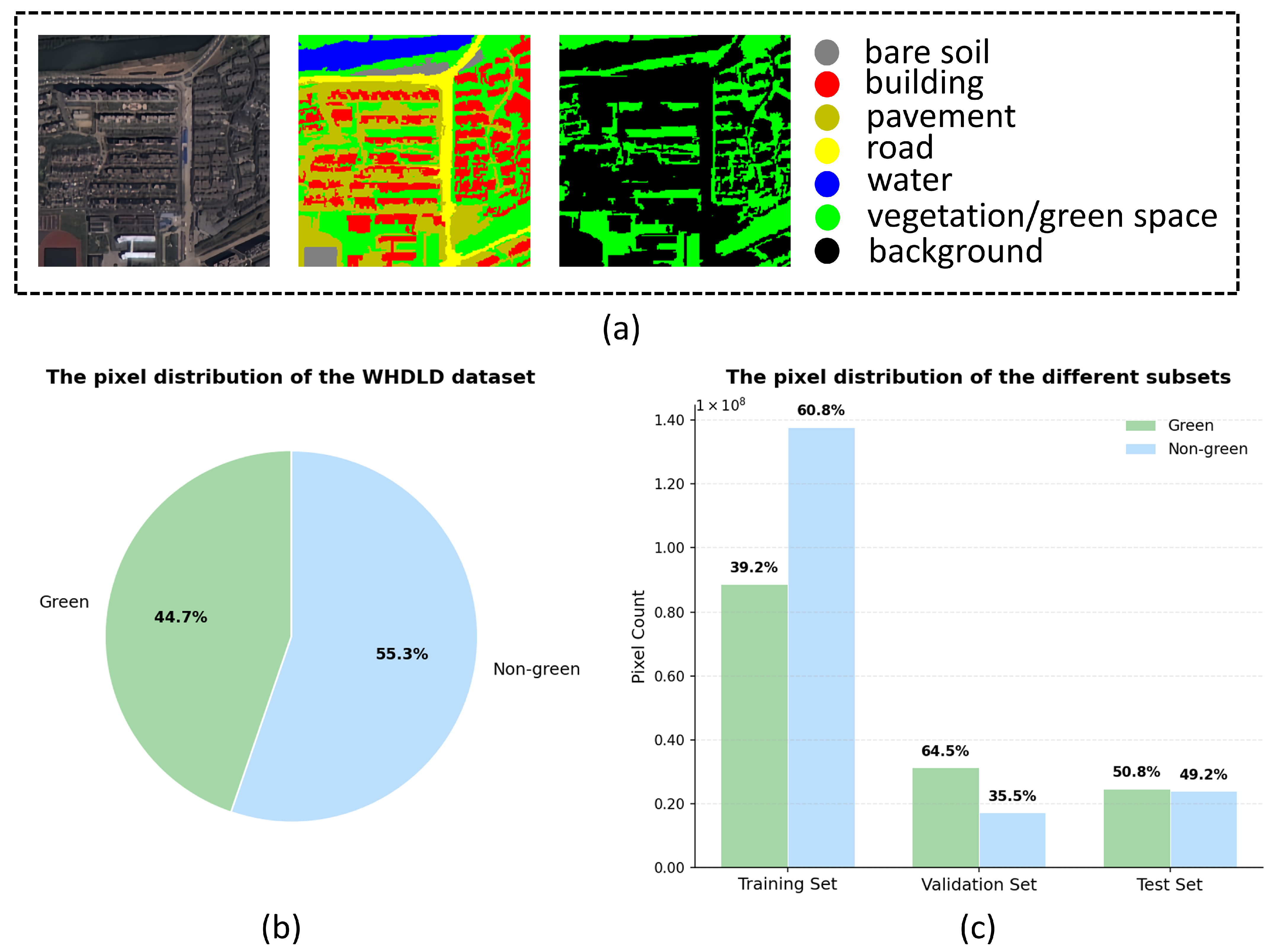
The Wuhan Dense Labeling Dataset (WHDLD) [33] is a widely used benchmark for semantic segmentation of high-resolution remote sensing imagery. It was collected over Wuhan, China, and contains 4940 image–label pairs with a spatial resolution of 2 m and an image size of 256 × 256 pixels. The original annotations comprise six land-cover categories, including buildings, roads, vegetation, sidewalks, bare land, and water bodies. It features a complex urban scene structure and covers areas with different vegetation coverage ratios. Therefore, this study retains all the original samples to maintain the scene diversity of the dataset and enhance the model’s ability to learn the characteristics of green spaces under different background conditions. Subsequently, to align the dataset with the urban green space segmentation task, the original multi-class annotations were reformulated into a binary classification scheme. Specifically, the vegetation category was retained as the target green space class, whereas all remaining land-cover categories were merged into a single background class. Representative samples of the processed dataset are presented in Figure 1a. The dataset was randomly divided into training, validation, and test subsets at a ratio of 7:1.5:1.5, yielding 3485, 741, and 741 image–label pairs, respectively. The pixel distribution of the entire dataset and different subsets is shown in Figure 1b,c.

2.2. UGS-1m Dataset

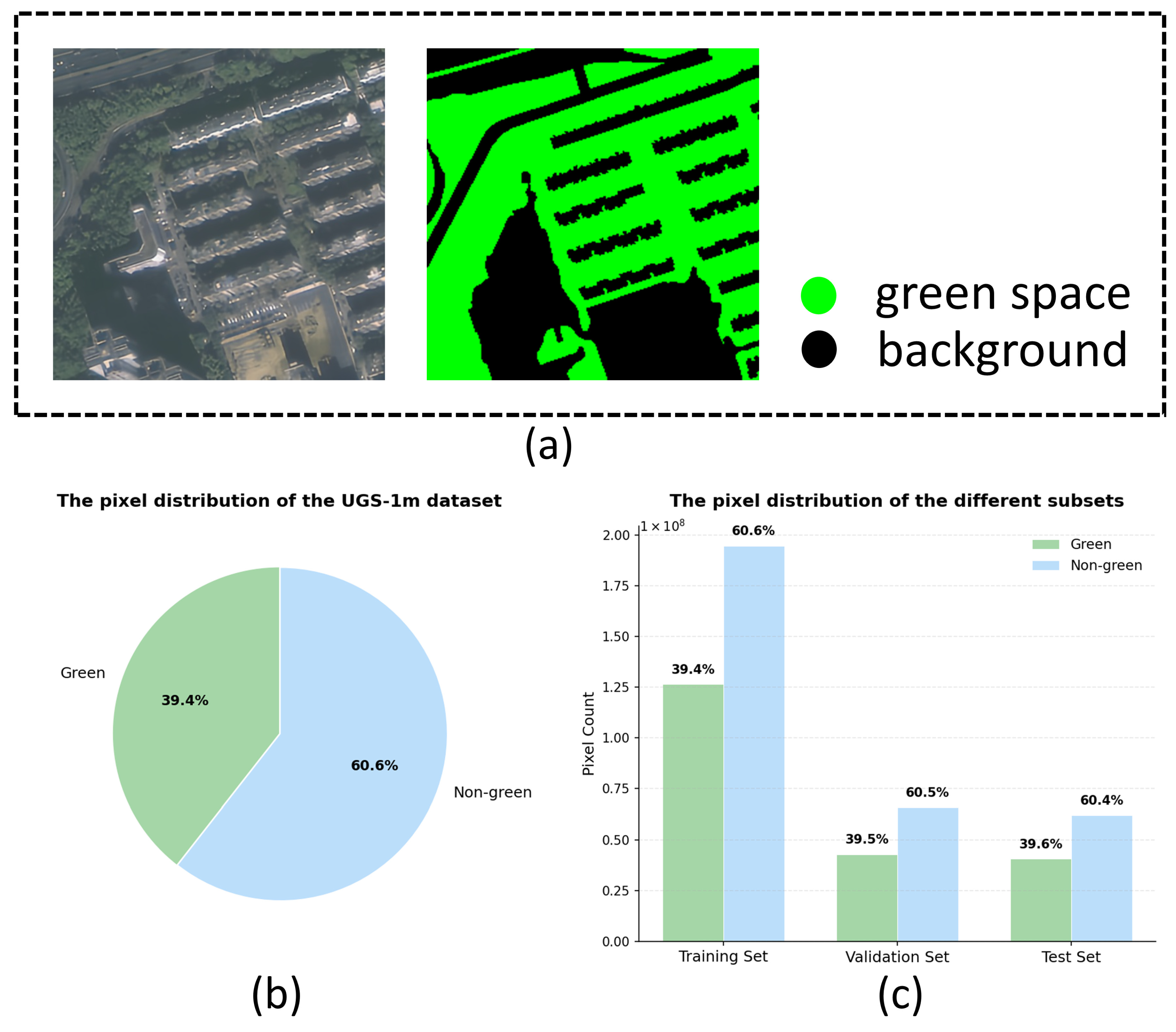
The Urban Green Space-1m (UGS-1m) dataset [34] is a densely annotated benchmark for urban green space segmentation, derived from high-resolution remote sensing imagery acquired over Guangdong Province, China. The imagery has a spatial resolution of approximately 1 m, and the original image size of 512 × 512 pixels was uniformly cropped into 256 × 256 pixel patches to ensure consistency in model training and evaluation. The dataset contains two classes, namely urban green space and background, with representative samples shown in Figure 2a. To improve training stability and reduce the influence of highly imbalanced samples, image patches with urban green space coverage below 20% or above 80% were excluded following commonly adopted preprocessing strategies in previous studies. After filtering, the dataset comprises 4899, 1658, and 1569 image–label pairs for the training, validation, and test sets, respectively. The pixel distribution of the entire dataset and each subset is shown in Figure 2b,c.

2.3. UBGG Dataset

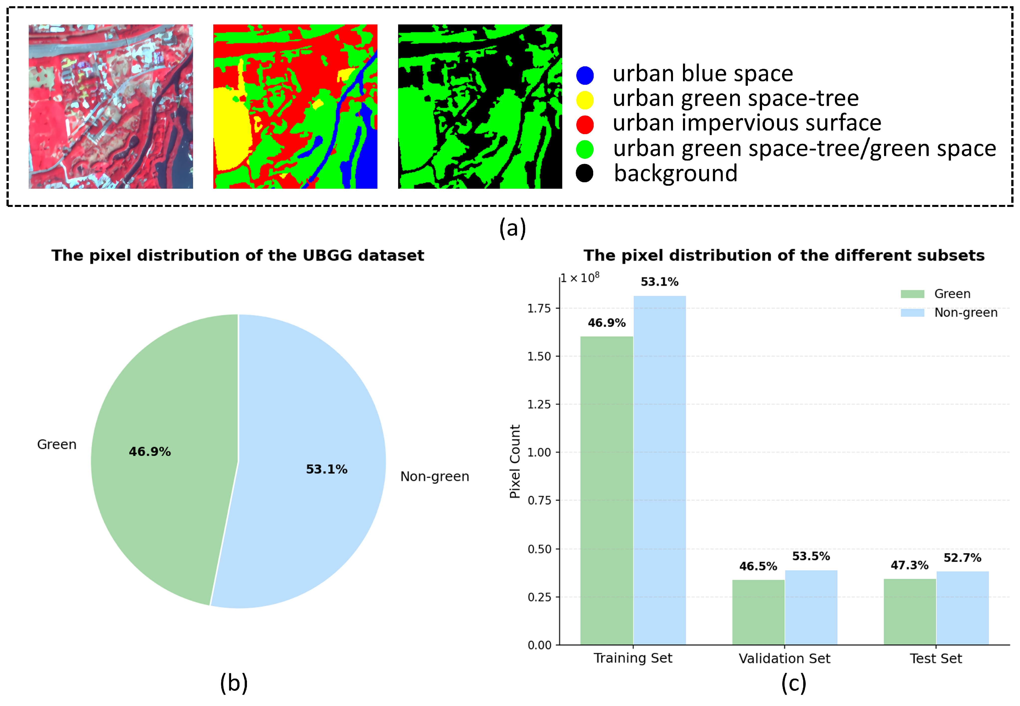
The Urban Blue–Green–Grey (UBGG) dataset [35] is a high-resolution remote sensing dataset developed for detailed mapping of urban blue, green, and grey landscapes. The imagery comprises three spectral bands, including near-infrared (NIR), red, and green, with a spatial resolution of approximately 3 m and image dimensions of 256 × 256 pixels. The original annotations distinguish four land-cover categories: urban blue space (UBS), urban green space—tree (UGS-Tree), urban green space—grass (UGS-Grass), and urban impervious surface (UIS). To adapt the dataset to the urban green space segmentation task, UGS-Tree and UGS-Grass were merged into a single urban green space class, while UBS and UIS were combined into a background class. Following the same preprocessing strategy adopted for the UGS-1m dataset, image patches with green space coverage below 20% or above 80% were removed to reduce the influence of extreme samples and improve dataset balance. Representative samples are shown in Figure 3a. After filtering, 7460 valid image–label pairs were retained. The dataset was subsequently divided into training, validation, and test sets at a ratio of 7:1.5:1.5, resulting in 5222, 1119, and 1119 image–label pairs, respectively. The pixel distribution of the entire dataset and each subset is shown in Figure 3b,c.

3. Methods

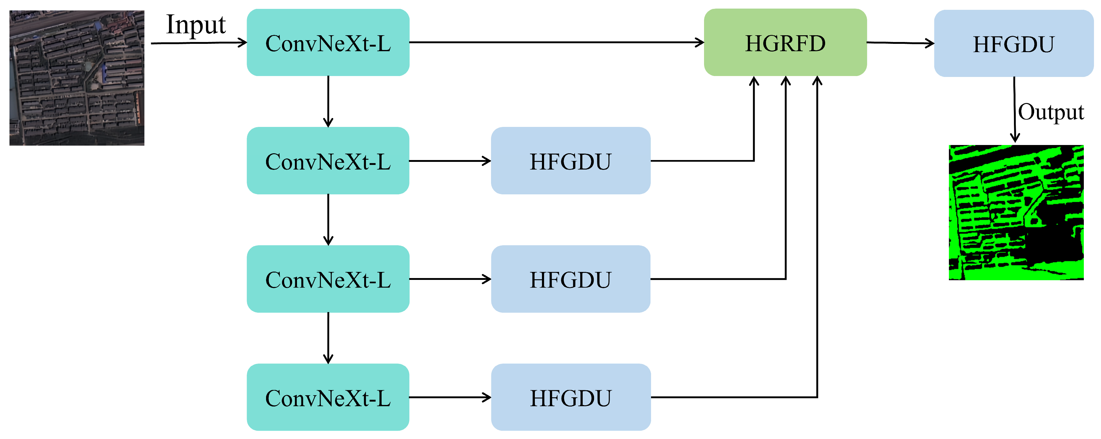
We propose HGRHDNet, a deep learning framework with an encoder–decoder architecture for urban green space semantic segmentation. ConvNeXt-L serves as the encoder backbone to extract hierarchical feature representations from high-resolution remote sensing imagery. To effectively integrate multi-level features, a HGRFD is developed, which progressively fuses semantic and spatial information while preserving boundary details and fragmented green space structures through residual connections. In addition, a HFGDU is incorporated to perform feature alignment and adaptive upsampling, thereby enhancing boundary localization and recovering high-frequency details. The overall architecture of HGRHDNet is illustrated in Figure 4.

3.1. Encoder

In urban green space segmentation, widely used backbone networks such as ResNet provide stable optimization and strong transferability. However, their reliance on stacked small-kernel convolutions limits the effective receptive field, making it difficult to capture large-scale green space structures and long-range contextual dependencies. Moreover, the progressive downsampling process may weaken fine spatial details, resulting in inaccurate boundary delineation and missed detection of small green space objects [36,37]. To address these limitations, ConvNeXt-L [38] is adopted as the encoder backbone in this study. By combining large-kernel convolutions with a modernized convolutional design, ConvNeXt-L enhances multi-scale feature representation and expands the receptive field while maintaining the computational efficiency and deployment flexibility of conventional CNNs. The extracted hierarchical features provide a robust foundation for subsequent boundary reconstruction and small-object segmentation.
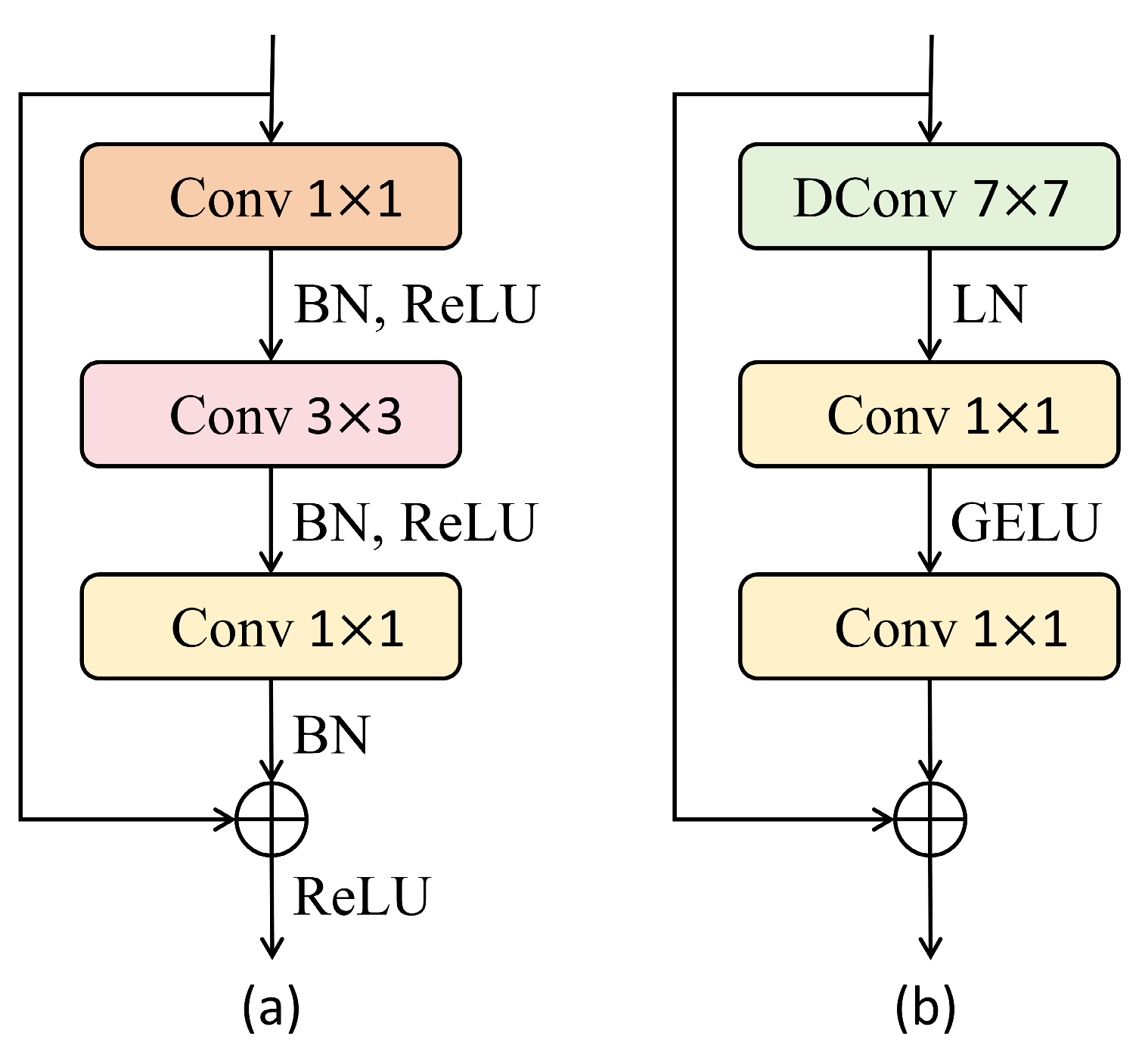
ConvNeXt is a pure convolutional architecture that incorporates several design principles inspired by Vision Transformers [39]. Compared with the conventional ResNet architecture (Figure 5a), ConvNeXt employs large-kernel depthwise convolutions (7 × 7) instead of densely stacked 3 × 3 convolutions, thereby enlarging the effective receptive field and improving contextual modeling capability (Figure 5b). In addition, the residual block is redesigned as an inverted bottleneck structure consisting of channel expansion, depthwise spatial mixing, and channel reduction, which is analogous to the feature transformation process of Transformer Multilayer Perceptron (MLP) blocks [40]. The network further simplifies normalization and activation operations by adopting LayerNorm and GELU, contributing to stable optimization and efficient feature learning. Among the available ConvNeXt variants, ConvNeXt-L is selected owing to its strong representation capacity. The network consists of four stages with channel dimensions of 192, 384, 768, and 1536 and residual block numbers of 3, 3, 27, and 3, respectively. Such a configuration enables the extraction of rich semantic representations across multiple scales, which is particularly beneficial for handling substantial scale variations among urban green spaces and preserving small, fragmented vegetation structures. The encoder outputs a set of hierarchical feature maps, denoted as { F s } s = 1 S (where s denotes the scale index and S the total number of scales), which are subsequently fed into the proposed decoder for feature fusion and boundary refinement.

3.2. Hierarchical Gated Residual Fusion Decoder

Feature fusion is a critical component of semantic segmentation decoders. Existing decoders predominantly adopt a layer-by-layer progressive fusion strategy, which recovers spatial resolution through stepwise upsampling and fuses deep features with shallow features via simple element-wise addition or concatenation operations. For example, U-Net [24] concatenates shallow and deep features through skip connections, FPN [23] employs a top-down pathway for element-wise fusion of multi-scale features, DeepLabv3+ [25] gradually restores spatial information through its decoder, and PANet [41] introduces an additional bottom-up path enhancement upon FPN. HRNet [42] maintains high-resolution representations throughout by leveraging parallel multi-resolution subnetworks and cross-resolution information exchange.
Although effective, such approaches implicitly assume equal contributions from features at different scales and often overlook the complementary roles of semantic and spatial information. Consequently, deep semantic representations tend to dominate the fusion process, leading to the suppression of fine-grained spatial details contained in shallow features. Moreover, repeated interpolation and convolution operations during progressive upsampling inevitably degrade high-frequency information and spatial precision. This issue is particularly pronounced in urban green space segmentation, where numerous small vegetation patches, narrow roadside green belts, and irregular boundary structures are present. The loss of shallow high-frequency information often results in blurred boundaries, fragmented predictions, and the omission of small green space objects.
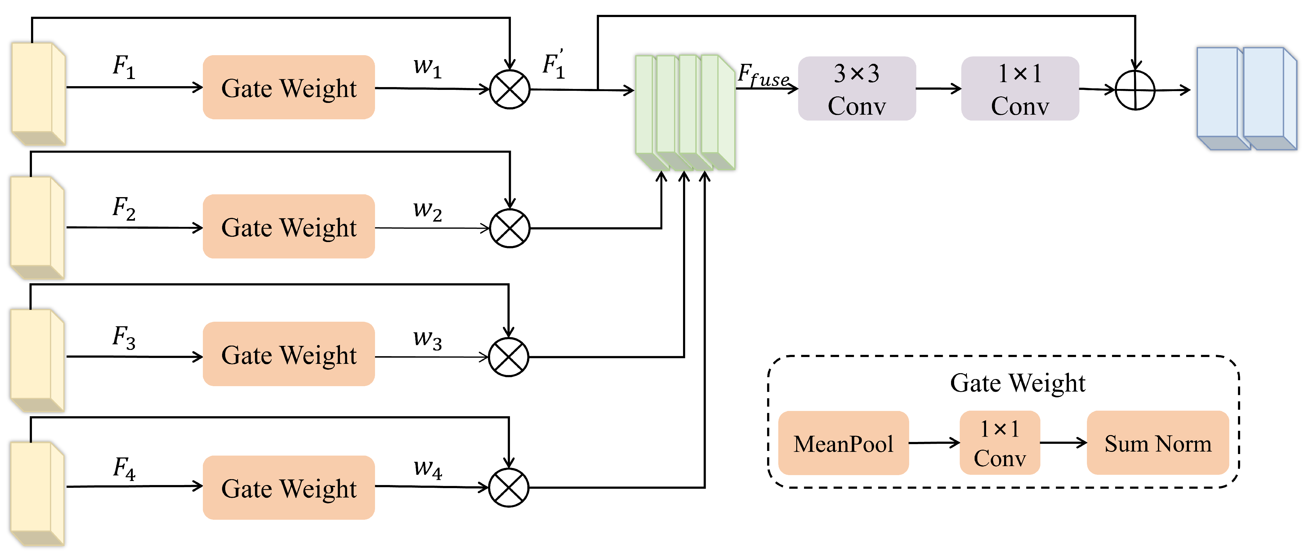
To address these limitations, a HGRFD is proposed to aggregate the multi-scale feature maps { F s } s = 1 S extracted by ConvNeXt-L. Compared with existing methods, the core differences in HGRFD are twofold. First, it introduces a learnable gated weighting mechanism to replace fixed fusion coefficients, dynamically adjusting the contribution strength of each scale feature according to its relative importance to the segmentation task, thereby alleviating the scale imbalance problem in multi-scale fusion. Second, it incorporates an explicit residual connection in the shallow branch, adding the original shallow features element-wise to the fused features, which structurally ensures that edge and texture information are not diluted by deep semantic information during forward propagation, thus improving the spatial accuracy of the segmentation results. The overall architecture of HGRFD is illustrated in Figure 6.
For the features F s at each scale to be fused, features of different scales inherently possess distinct attribute tendencies: deeper features, with larger receptive fields, encode more semantic information, whereas shallower features, with smaller receptive fields, preserve richer spatial details. Consequently, directly assigning identical fusion coefficients to all scales fails to dynamically balance the relative importance of the two types of information according to the image content. To address this issue, we design a gated weighting mechanism that adaptively adjusts the contribution of each scale feature during fusion by learning its importance across scales. Specifically, adaptive average pooling is first applied to compress the spatial dimensions of each scale feature into a global response vector, which reflects the semantic activation intensity of that feature in the overall scene. This vector is then passed through a 1 × 1 convolution for channel mapping, learning a projection from the global response to scale-wise importance. Finally, Sum-Norm normalization is employed to generate the fusion weights w s , which convert the mapped results into a probability distribution that sums to unity:
w s = S u m _ N o r m ( C o n v 1 × 1 ( M e a n P o o l ( F s ) ) )
The weight w s directly indicate the relative importance of the different scale features for the current segmentation task. More importantly, these weights are jointly optimized with the ConvNeXt-L backbone in an end-to-end manner through the segmentation loss function. During training, gradients are backpropagated to the weight generation module, driving the weights to update in a direction that reduces the segmentation loss. In the optimization process, if increasing the weight of a particular scale can more effectively reduce the loss, the gradient descent mechanism will encourage a corresponding increase in that weight. Thus, the final weight distribution is the outcome of optimization guided by the loss function on the training data. This mechanism enables the gated weights to learn a data-driven adaptive fusion strategy conditioned on the input image content, thereby achieving a dynamic and reasonable trade-off between deep semantic information and shallow spatial details. Eventually, the weighted fusion of all scale features yields the fused feature F f u s e :
F f u s e = s = 1 S w s · F s
Furthermore, to preserve the high-frequency details in shallow features, we introduce an explicit residual connection in the s = 1 branch (corresponding to the 1/4 scale), where the original shallow feature F 1 is added element-wise to the fused feature F f u s e :
F f i n a l = F 1 + F f u s e
This mechanism prevents boundary and texture information contained in shallow features from being overwhelmed by deep semantic representations during feature propagation, thereby improving the spatial precision of the segmentation results.

3.3. Traditional Upsampling Methods

In encoder–decoder architectures, the upsampling operation plays a crucial role in restoring feature resolution and directly affects the quality of the final segmentation results. Traditional upsampling methods mainly include nearest-neighbor interpolation and bilinear interpolation [43,44]. Nearest-neighbor interpolation assigns each target pixel the value of its closest pixel in the original feature map. Owing to its low computational complexity, this method is widely adopted in real-time applications. However, it often introduces noticeable aliasing artifacts and jagged boundaries. Bilinear interpolation estimates the value of a target pixel by taking the grayscale values of its four nearest neighboring pixels, performing two linear interpolations in the horizontal direction followed by one in the vertical direction (or vice versa), and ultimately computing a weighted average of these four values. Compared with nearest-neighbor interpolation, this strategy produces smoother spatial transitions and substantially reduces staircase artifacts. Despite these advantages, bilinear interpolation is fundamentally constrained by its local linear approximation. While it smooths discontinuities, it cannot reconstruct high-frequency information lost during encoding. Consequently, boundary structures and fine spatial details are often oversmoothed during upsampling. This limitation is particularly detrimental to urban green space segmentation, where numerous small vegetation patches and irregular boundaries require precise spatial localization. Therefore, a more adaptive upsampling mechanism capable of preserving high-frequency details and achieving accurate feature alignment is required.

3.4. High-Frequency Guided Deformable Upsampler

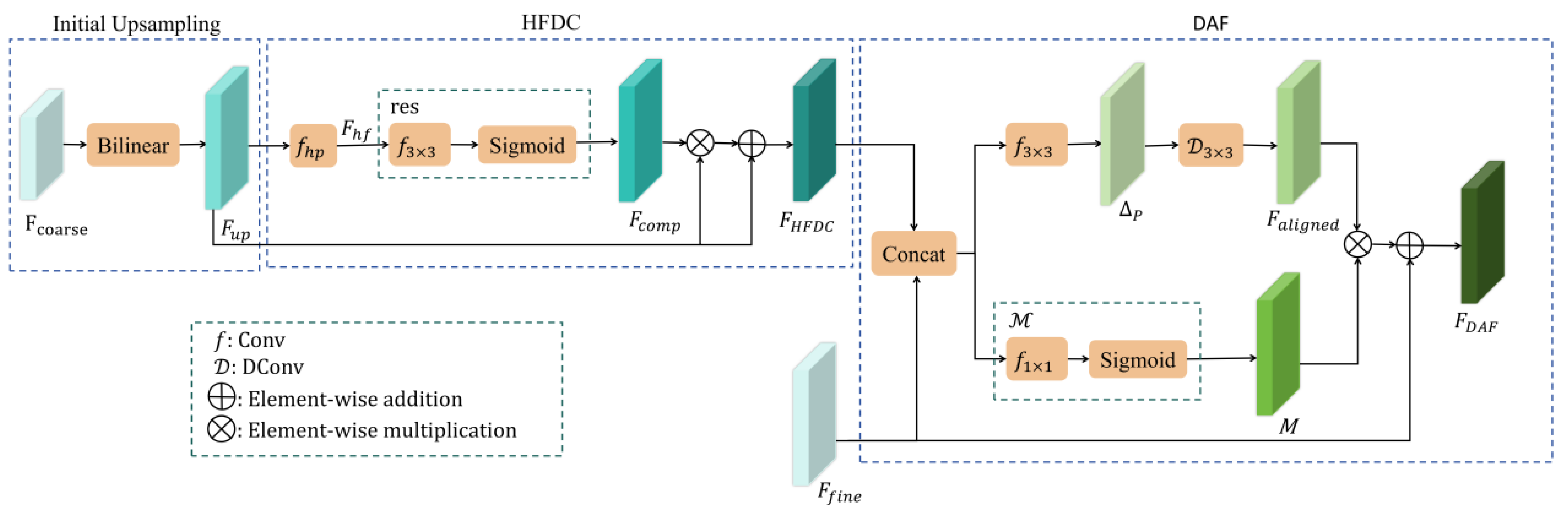
To overcome the limitations of traditional sampler methods, HFGDU [45] introduces a high-frequency compensation and a deformable alignment fusion module, which addresses the problem of inaccurate detection of small target groups in crowd detection scenarios due to detail loss, boundary blurring, and feature misalignment during upsampling. However, this method has never been applied to urban green space scenes. Therefore, this paper employs HFGDU to replace traditional upsampling methods, and its structure is shown in Figure 7. The coarse-resolution feature F c o a r s e is upsampled to the target size F u p through bilinear interpolation. Subsequently, F u p is fed into the High-Frequency Detail Compensation (HFDC) module, where a high-pass filter ( f h p ) and a compensation generator (res) are used to enhance the recovery of high-frequency information at green space boundaries, producing F H F D C . Finally, F H F D C is passed into the Deformable Alignment Fusion (DAF) module to achieve accurate alignment and fusion of cross-resolution features.

3.4.1. High-Frequency Detail Compensation

To avoid the blurring of green boundaries and loss of detail caused by upsampling, the HFDC branch employs a learnable high-pass filter f h p (designed based on a Laplacian-like structure) to convolve F u p , extracting its high-frequency component F h f . The Laplacian-like operator fundamentally responds to second-order spatial variations in the feature map. Since its response magnitude is notably higher in regions of abrupt intensity transitions, which correspond to the spatial boundaries between different land-cover categories, this high-pass filtering process effectively functions as an edge enhancement operation, enabling the extraction of high-frequency structural information along green-space contours. Subsequently, a residual compensation generator r e s refines F h f . Specifically, r e s extracts high-frequency features through a 3 × 3 convolution f 3 × 3 , followed by a Sigmoid activation to obtain the compensation weight F c o m p . Finally, to prevent over-compensation-induced deviation, a residual structure is introduced to fuse F c o m p with the input feature F u p , producing the compensated high-frequency detail map F H F D C :
F H F D C = F u p ( 1 + F c o m p )
where denotes element-wise multiplication. The design of the residual structure enables the module to stably preserve the base information while progressively learning fine-grained high-frequency compensation targeting green boundaries.

3.4.2. Deformable Alignment Fusion

Although the HFDC branch restores certain boundary details via high-frequency enhancement, its features originate from low-resolution levels and are susceptible to positional displacement upon spatial recovery. This displacement arises from both the compression of spatial information during downsampling and the fixed mapping rules of interpolation-based upsampling. Repeated downsampling degrades spatial localization accuracy and shifts boundary responses, while conventional upsampling, governed by fixed sampling rules, cannot accommodate the structural variability of diverse targets. As a result, the high-frequency detail compensated feature F H F D C and their fine-resolution feature F f i n e remain spatially misaligned around object boundaries and detailed regions, hindering effective multi-scale feature integration.
To address the problem of spatial misalignment between the high-frequency detail compensated feature F H F D C and the fine-resolution feature F f i n e , a DAF module is introduced. This module concatenates the high-frequency detail feature F H F D C with the corresponding fine-resolution feature F f i n e along the channel dimension, and then employs a lightweight offset prediction network f 3 × 3 to adaptively generate spatial offsets P for each sampling position. Subsequently, a deformable convolution layer D 3 × 3 is applied to resample F H F D C according to the predicted offsets P , producing a deformably sampled feature map F a l i g n e d that corrects the misalignment. In addition, a gating mechanism M , consisting of a 1 × 1 convolution followed by a Sigmoid function, is introduced to adaptively fuse the deformably sampled feature map F a l i g n e d with the fine-resolution feature F f i n e , generating adaptive fusion weights M . The final fused feature F D A F is given by:
F D A F = M F a l i g n e d + F f i n e  
where denotes element-wise multiplication.
By integrating a high-pass filter, offset prediction for deformable convolution, and a gating mechanism, the HFGDU module effectively recovers high-frequency details and achieves precise feature alignment, thereby enhancing processing quality for complex textures and fine boundaries.

4. Experiment

4.1. Experimental Environment and Evaluation Metrics

All experiments were conducted on a Linux platform equipped with an NVIDIA GeForce RTX 4090 GPU (NVIDIA, Santa Clara, CA, USA) with 24 GB of GPU memory. The proposed framework was implemented using PyTorch 1.11.0 and CUDA 11.3. During training, the AdamW optimizer was adopted with an initial learning rate of 2 × 10 5 and a weight decay of 1 × 10 4 . The learning rate schedule employed a cosine annealing warm restart strategy, where the initial restart period is set to one-tenth of the total number of iterations, the period multiplier is 2, and the minimum learning rate is 1 × 10 6 . The loss function was a linearly weighted combination of cross-entropy loss and dice loss, with both weights set to 0.5. The batch size during training is set to 2, and the number of training epochs is 100.
To comprehensively evaluate segmentation performance, six widely used metrics were employed, including Mean Pixel Accuracy (MPA) [46], Mean Intersection over Union (MIoU) [47], Frequency Weighted Intersection over Union (FWIoU) [48], Mean F1-score (MF1) [49], Kappa coefficient (Kappa) [50], and Boundary Intersection over Union (BIoU) [51]. The formulas for these metrics are as follows:
M P A = 1 k + 1 i = 0 k p i i j = 0 k p i j
M I o U = 1 k + 1 i = 0 k p i i j = 0 k p i j + j = 0 k p j i p i i  
F W I O U = 1 i = 0 k j = 0 k p i j i = 0 k j = 0 k p i j p i i j = 0 k p i j + j = 0 k p j i p i i
P = p i i p i i + p i j  
R = p i i p i i + p j i  
M F 1 = 1 k + 1 i = 0 k 2 · P i · R i P i + R i  
P 0 = i = 0 k p i i i = 0 k j = 0 k p i j
P e = i = 0 k ( j = 0 k p i j · j = 0 k p j i ) ( i = 0 k j = 0 k p i j ) 2
K a p p a = P 0 P e 1 P e  
B I o U = | ( G d G m ) ( P d P m ) | | ( G d G m ) ( P d P m ) |
where p i i , p j i , p i j and p j j denote true positives, false positives, false negatives, and true negatives, respectively; k represents the number of object classes excluding the background; G m and P m denote the ground truth mask and the predicted mask, respectively; G d and P d represent the sets of pixels within a distance of d pixels from the ground truth contour and the predicted contour (i.e., the boundary areas), respectively; and the value of d is set to 2% of the image diagonal length, which corresponds to 5 pixels in our datasets, following Cheng et al. [51], where this threshold was empirically validated to balance boundary localization sensitivity and annotation uncertainty. Furthermore, to more rigorously evaluate the model performance in tight boundary regions, we additionally set d to 3 pixels for supplementary experiments. Unlike metrics such as MIoU and F1, which primarily focus on measuring the overall overlap between regions, the BIoU is specifically devised to assess the consistency between predicted boundaries and ground-truth boundaries, thereby directly indicating the model’s capability in edge localization. The accuracy of boundary localization is particularly critical for estimating the area of objects such as elongated green belts and small scattered patches, as well as for the subsequent computation of ecological assessment indices, including landscape fragmentation and connectivity.

4.2. Ablation Experiments

To evaluate the contributions of ConvNeXt-L, HGRFD, and HFGDU, ablation experiments were conducted on the WHDLD. The quantitative results are summarized in Table 1. Using ConvNeXt-L as the encoder backbone and a simple upsampling decoder as the baseline, the model achieved an MIoU of 83.74%. Replacing the baseline decoder with a multi-scale fusion decoder increased the MIoU to 84.96%, yielding an improvement of 1.22 percentage points. This improvement demonstrates the effectiveness of aggregating multi-scale semantic and spatial information from different encoder stages. When the multi-scale fusion decoder was further replaced by the proposed HGRFD with bilinear upsampling, the MIoU increased to 85.18%. Compared with the conventional multi-scale fusion strategy, HGRFD adaptively learns the relative importance of features at different scales, enabling a more balanced integration of global semantic information and local spatial details. Finally, replacing bilinear interpolation with the proposed HFGDU further improved the MIoU to 85.56% and the BIoU to 43.82%. Relative to the baseline model, the improvements reached 1.82 percentage points in MIoU and 11.00 percentage points in BIoU. Compared with HGRFD using bilinear upsampling, HFGDU achieved additional gains of 0.38 percentage points in MIoU and 1.68 percentage points in BIoU. The substantial improvement in BIoU indicates that HFGDU effectively enhances boundary reconstruction through high-frequency detail compensation and deformable feature alignment, leading to more accurate delineation of urban green spaces and superior overall segmentation performance.
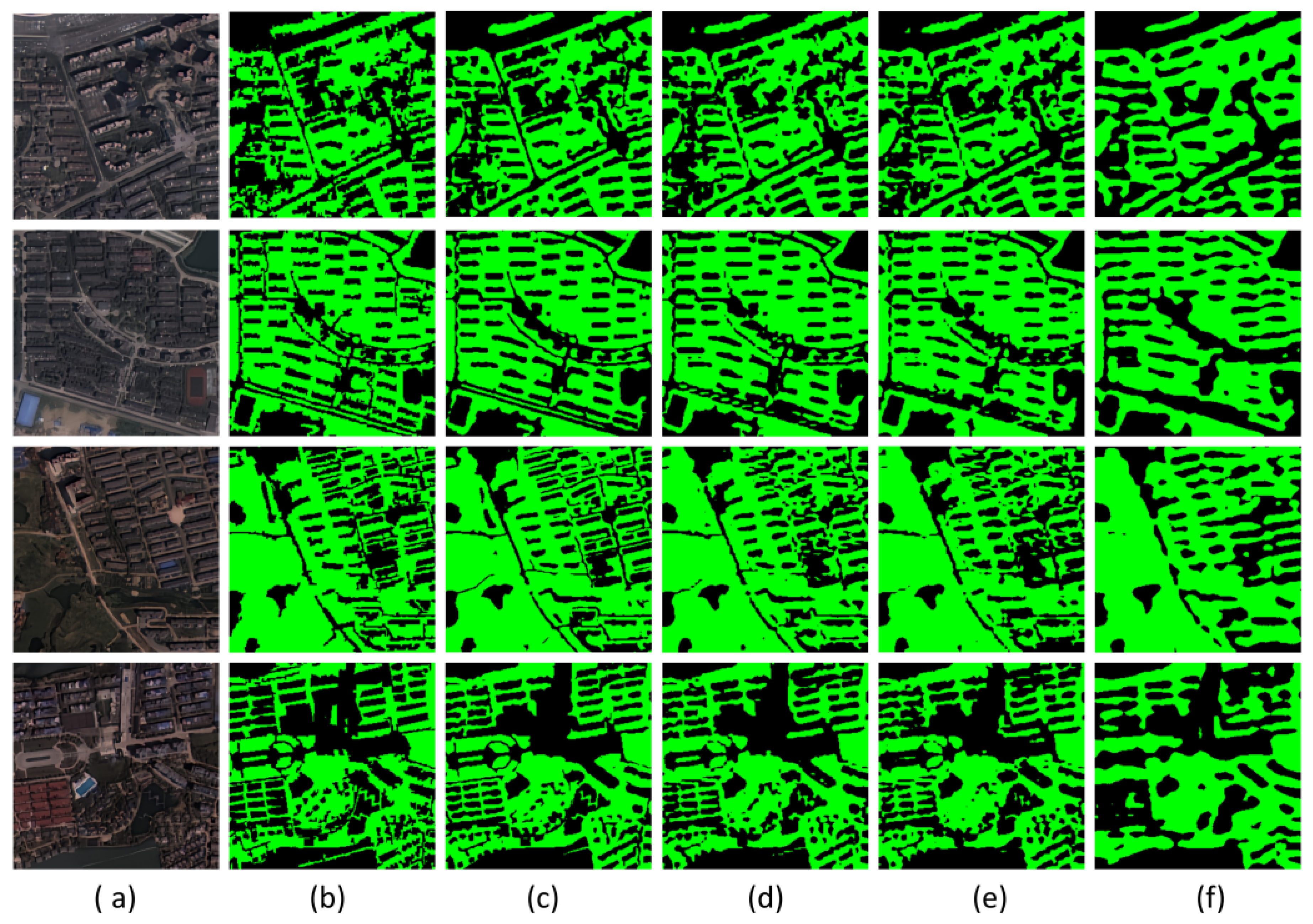
The qualitative results of the ablation study are presented in Figure 8. Consistent with the quantitative results in Table 1, the visual comparisons demonstrate the progressive improvement achieved by the proposed modules. The baseline model equipped with a simple upsampling decoder exhibits noticeable false positives and fragmented predictions, resulting in irregular segmentation contours and limited agreement with the ground-truth annotations. After replacing the baseline decoder with the MultiScale_Fusion_decoder, the overall continuity and completeness of the segmented green spaces are improved, indicating that multi-scale feature aggregation effectively enhances semantic representation. However, boundary delineation remains relatively coarse, and inaccuracies are still observed in densely built urban areas and regions with irregular vegetation structures. When the proposed HGRFD is introduced, the segmentation results become more consistent with the reference annotations. The adaptive fusion strategy and residual feature preservation mechanism enable better retention of spatial details, leading to more accurate delineation of green space regions. Nevertheless, certain fine structures and narrow vegetation patches remain challenging to recover using conventional bilinear upsampling. Further improvements are achieved by replacing bilinear interpolation with the proposed HFGDU. Benefiting from high-frequency detail compensation and deformable feature alignment, the model produces sharper boundaries and more complete representations of small and elongated green space objects. In complex urban scenes, the predictions exhibit improved spatial consistency and closer correspondence with the ground-truth labels. These observations demonstrate that the proposed HGRFD and HFGDU modules effectively enhance both feature representation and detail reconstruction, resulting in superior urban green space segmentation performance.

4.3. Comparison Experiments

To comprehensively evaluate the effectiveness of the proposed HGRHDNet, a series of representative deep learning models were selected for comparison, including HRNet, SegFormer, UNetFormer, LOGCAN, SACANet, Swin-CFNet, DOCNet, and LOGCAN++. The performance of all models was assessed using six evaluation metrics, namely MPA, MIoU, FWIoU, F1-score, Kappa, and BIoU. The selected comparison methods can be broadly categorized into two groups. The first group consists of models specifically designed to enhance detail preservation and boundary delineation. HRNet maintains parallel high- and low-resolution feature streams to improve spatial localization accuracy [42]. SegFormer adopts a hierarchical Transformer encoder and a lightweight decoder for efficient multi-scale feature aggregation [52]. UNetFormer integrates Transformer-based global context modeling with U-Net-style feature fusion to improve the segmentation of small and complex objects [53]. The second group comprises state-of-the-art remote sensing image segmentation models that have demonstrated strong performance in complex scene understanding. LOGCAN employs global and local class-aware modules to reduce background interference and intra-class variability [54]. SACANet incorporates scene-aware spatial attention and local-global class attention mechanisms to enhance contextual representation [55]. Swin-CFNet combines Swin Transformer and CNN architectures to strengthen both local feature extraction and global information modeling [28]. DOCNet introduces class-aware semantic-spatial optimization to improve segmentation in heterogeneous environments [56]. LOGCAN++ further extends LOGCAN by incorporating affine transformation-based feature adaptation to better handle scale and orientation variations [57]. These models represent a diverse range of CNN-, Transformer-, and attention-based architectures, providing a comprehensive benchmark for evaluating the effectiveness of the proposed HGRHDNet.
To comprehensively evaluate the computational efficiency of each model, Table 2 summarizes the parameter count and FLOPs of all compared methods. HGRHDNet adopts ConvNeXt-L as its backbone encoder, which entails a relatively large parameter count by design, aiming to harness its strong feature extraction capacity for improved boundary detail recovery. Despite this increase in model complexity, the subsequent comparative experiments on the three datasets show that the proposed method achieves notable gains in boundary accuracy metrics such as BIoU, confirming that the moderate computational cost is justified by the enhanced segmentation performance.

4.3.1. Comparison Experiment of the WHDLD

Table 3 summarizes the quantitative comparison results on the WHDLD. Overall, the proposed HGRHDNet achieves highly competitive performance and ranks among the best-performing methods across all evaluation metrics. Among the compared approaches, DOCNet achieves the highest global segmentation accuracy, with an MIoU of 85.57% and a Kappa coefficient of 84.45%. HGRHDNet attains an MIoU of 85.56% and a Kappa coefficient of 84.43%, exhibiting nearly identical performance to DOCNet in terms of overall segmentation accuracy. These results demonstrate that the proposed framework effectively captures semantic information while maintaining strong prediction consistency. More importantly, in terms of the boundary-oriented BIoU metric, HGRHDNet achieves 43.82% when d is set to 5 pixels, outperforming DOCNet (41.45%) and SACANet (42.00%) by 2.37 and 1.82 percentage points, respectively. When the threshold is tightened to 3 pixels, HGRHDNet still attains 28.38%, again surpassing DOCNet (26.48%) and SACANet (25.99%). The superior BIoU performance indicates that the proposed HGRFD and HFGDU modules substantially enhance boundary localization and high-frequency detail reconstruction, enabling more accurate delineation of complex green space boundaries. Therefore, while maintaining state-of-the-art overall segmentation accuracy, HGRHDNet provides a clear advantage in boundary refinement, which is particularly important for urban green space extraction in heterogeneous urban environments.
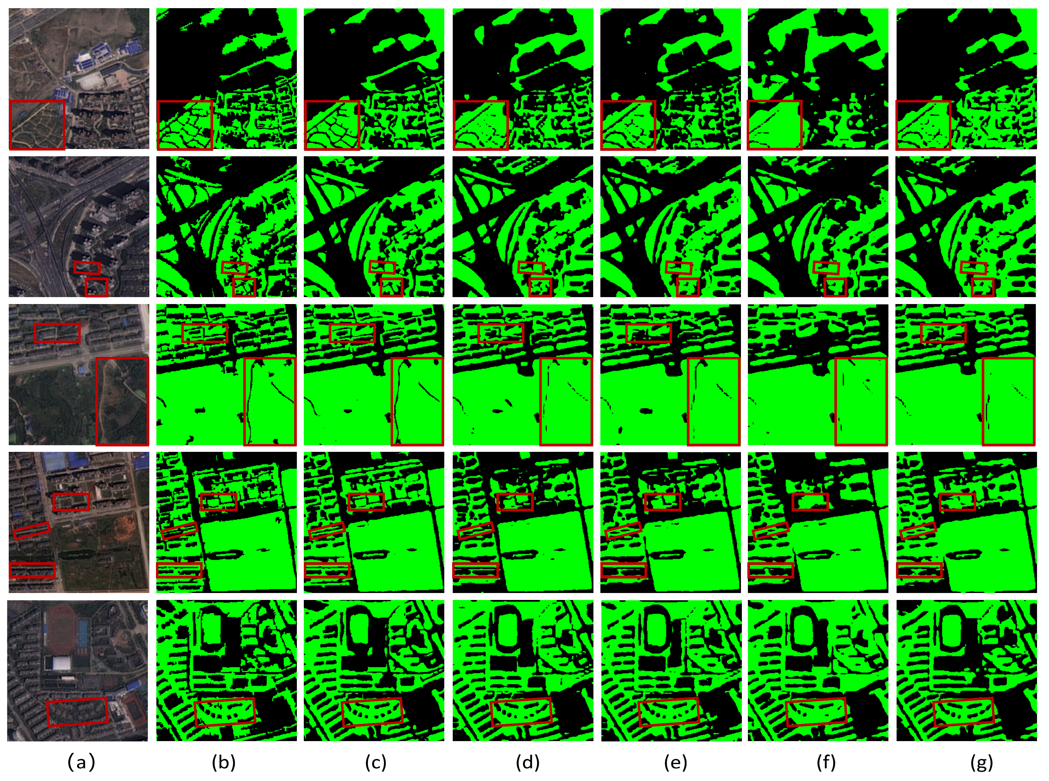
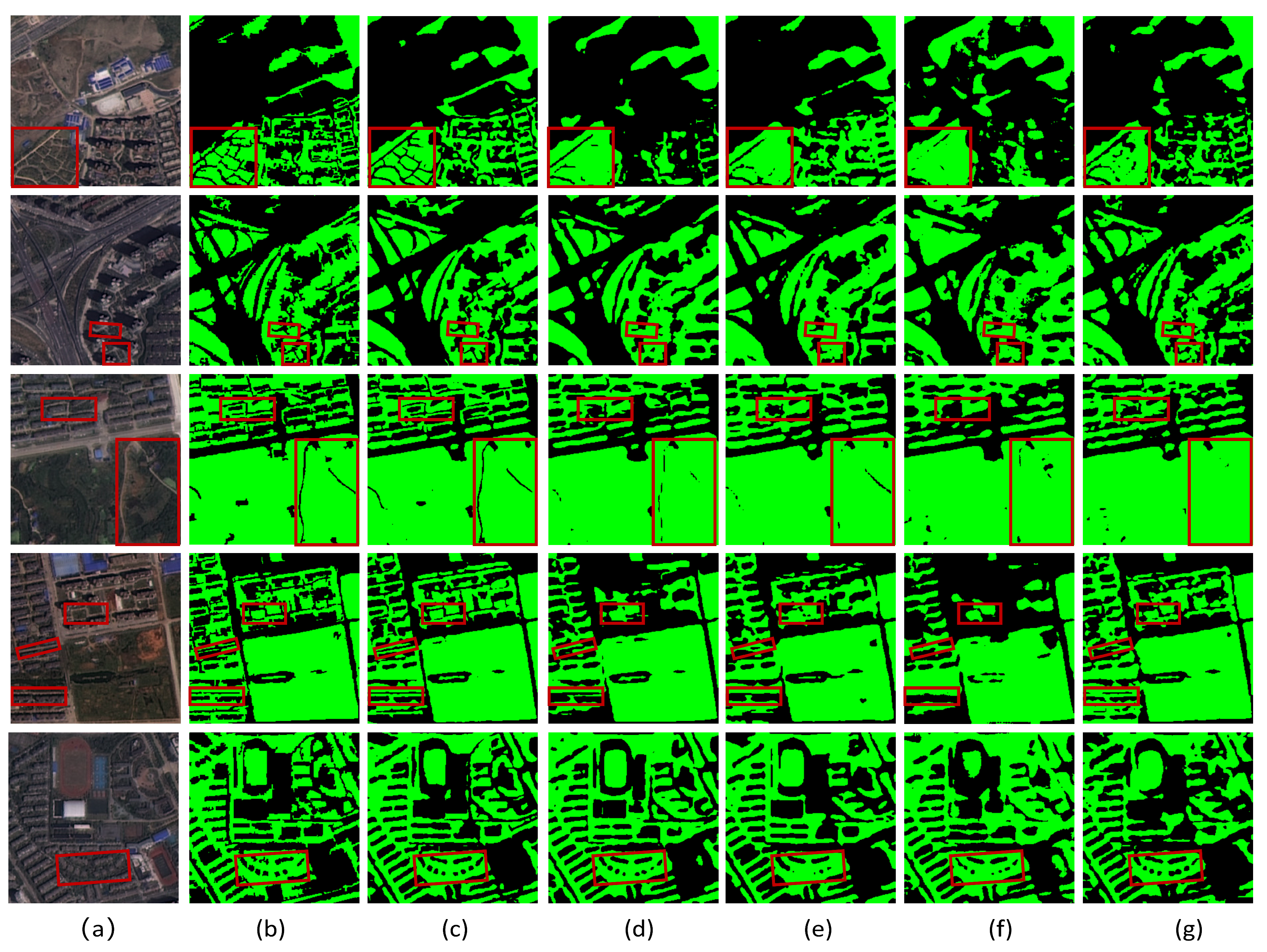
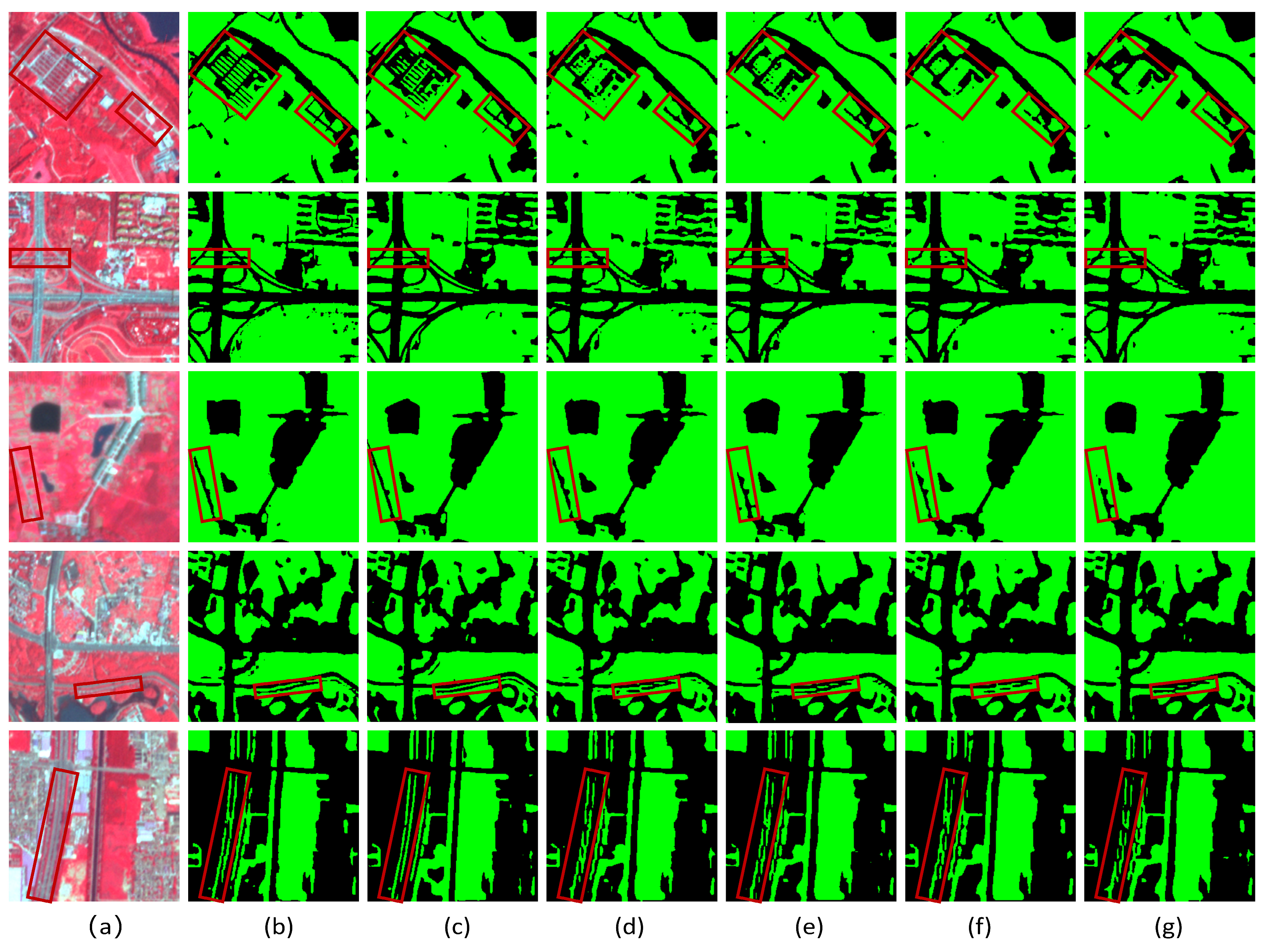
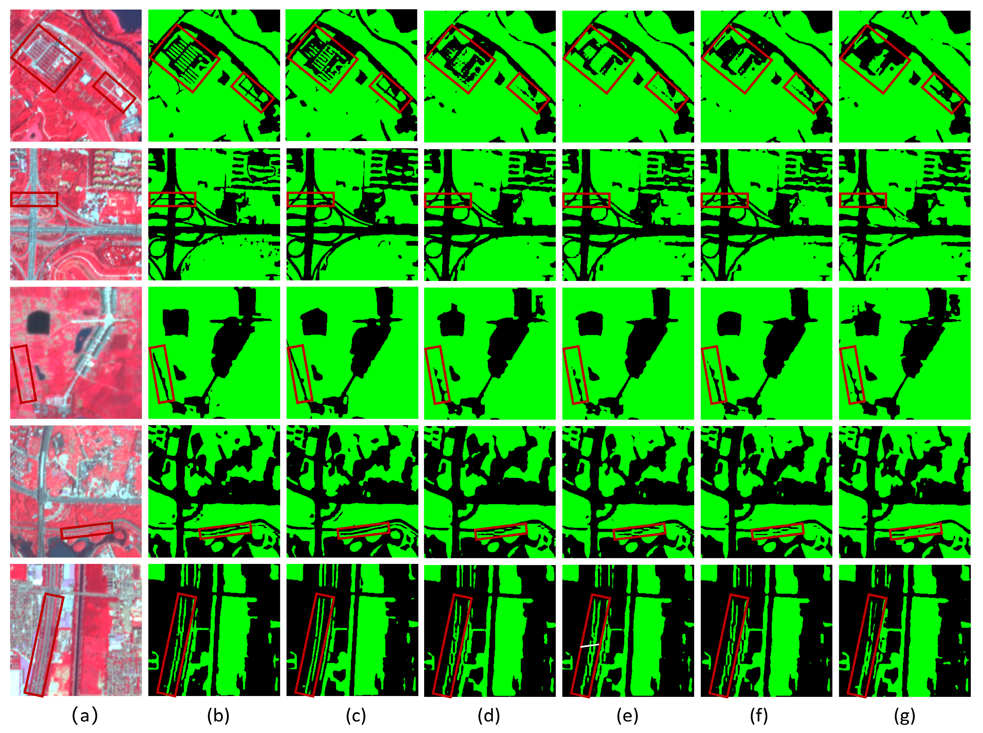
To further evaluate the effectiveness of the proposed method, qualitative comparisons were conducted on several representative samples from the WHDLD. The visualization results are presented in Figure 9 and Figure 10. In the first rows of Figure 9 and Figure 10, narrow roads embedded within green space regions are annotated as non-green space in the reference labels. Although DOCNet, SACANet, and UNetFormer correctly identify most green space regions, boundary expansion is observed around the road areas, causing adjacent green space patches to merge and leading to inaccurate boundary delineation. Other methods exhibit more severe over-segmentation, resulting in blurred boundaries and the loss of narrow non-green structures. In contrast, HGRHDNet better preserves the road regions and produces boundaries that are more consistent with the ground-truth annotations. The second row of Figure 9 and Figure 10 illustrates a challenging scenario involving building-induced shadow occlusion. In this case, several comparison methods incorrectly classify the narrow road regions between vegetation patches and adjacent buildings as green space, resulting in boundary inaccuracies. By comparison, HGRHDNet achieves a clearer separation between vegetation and surrounding non-green features, producing segmentation results that more closely resemble the reference labels. The examples shown in the third to fifth rows of Figure 9 and Figure 10 further demonstrate the robustness of HGRHDNet in complex urban environments. Most competing methods exhibit varying degrees of boundary erosion, omission of narrow green space structures, or confusion between vegetation and surrounding impervious surfaces. Benefiting from adaptive multi-scale feature fusion and enhanced high-frequency detail recovery, HGRHDNet preserves boundary integrity more effectively and reduces both omission and commission errors. Overall, the qualitative results are consistent with the quantitative evaluation presented in Table 3, demonstrating that the proposed framework provides more accurate boundary delineation and better preservation of small and fragmented urban green spaces while maintaining strong overall segmentation performance.

4.3.2. Comparison Experiment of the UGS-1m Dataset

Table 4 summarizes the quantitative comparison results on the UGS-1m dataset. Overall, all methods exhibit relatively limited performance, with MIoU values below 70% and Kappa coefficients below 65%, indicating the challenging nature of this dataset. Despite the difficulty of the task, the proposed HGRHDNet achieves highly competitive performance across all evaluation metrics. In terms of global segmentation accuracy, HGRHDNet achieves results comparable to those of UNetFormer, with the differences in MPA, MIoU, FWIoU, MF1, and Kappa all being within 0.1 percentage points. More importantly, HGRHDNet attains the highest BIoU value of 18.22% when d is set to 5 pixels, outperforming UNetFormer (17.57%) by 0.65 percentage points. When the threshold is tightened to 3 pixels, HGRHDNet still achieves 8.20% in terms of BIoU, again surpassing UNetFormer (7.89%). This result suggests that the proposed framework enhances boundary delineation while maintaining state-of-the-art overall segmentation performance. Such an advantage is particularly valuable for urban green space extraction, where accurate characterization of narrow boundaries and fragmented structures is essential.
Figure 11 and Figure 12 presents representative visual comparisons on the UGS-1m dataset. Overall, HGRHDNet demonstrates stronger capability in preserving narrow non-green gaps, such as roads separating adjacent green space patches. In the first row of Figure 11 and Figure 12, many competing methods either partially fill these narrow gaps or produce discontinuous gap structures, leading to the merging of neighboring green spaces. By contrast, HGRHDNet preserves the continuity of the gap regions more effectively and generates clearer green space boundaries. The second row of Figure 11 and Figure 12 depicts a densely vegetated scene in which roads appear as extremely narrow separations between green spaces. While several methods roughly capture the overall green space distribution, the widths of the preserved gaps often deviate from the reference labels, resulting in either over-segmentation or under-segmentation. HGRHDNet produces gap structures that more closely match the ground-truth annotations, leading to improved separation between adjacent vegetation regions. The examples shown in the third and fourth rows of Figure 11 and Figure 12 further highlight the robustness of HGRHDNet in complex urban environments. Under strong background interference from surrounding buildings, many competing methods struggle to preserve extremely fine gap structures and frequently exhibit gap filling or fragmented predictions. Benefiting from adaptive multi-scale feature fusion and enhanced high-frequency detail recovery, HGRHDNet maintains more complete gap structures and sharper boundary delineation. These visual observations are consistent with the quantitative BIoU improvements reported in Table 4, further demonstrating the effectiveness of the proposed framework for fine-grained urban green space segmentation.

4.3.3. Comparison Experiment of the UBGG Dataset

Table 5 presents the quantitative comparison results on the UBGG dataset. Unlike the WHDLD and UGS-1m datasets, which contain only RGB imagery, the UBGG dataset provides NIR, red, and green bands. The inclusion of the NIR band substantially enhances the spectral separability of vegetation and non-vegetation classes, resulting in generally high segmentation accuracy across all models. Among the comparison methods, SegFormer, HRNet, and DOCNet achieve relatively strong performance. SegFormer attains an MIoU of 92.59% and a Kappa coefficient of 92.31%, ranking among the best-performing baseline methods. The proposed HGRHDNet achieves the highest scores across all evaluation metrics, with an MIoU of 93.08% and a Kappa coefficient of 92.83%, representing improvements of 0.49 and 0.52 percentage points over SegFormer, respectively. For the boundary-oriented metric BIoU, HGRHDNet achieves 64.55% when the threshold d is set to 5 pixels, exceeding SegFormer (62.91%) by 1.64 percentage points. Under the stricter threshold of 3 pixels, HGRHDNet still attains a BIoU of 44.85%, outperforming SegFormer (41.70%), which fully demonstrates the effectiveness of our method in recovering fine boundary details. These results indicate that, under conditions where vegetation information is enhanced by the NIR band, HGRHDNet not only maintains superior overall segmentation accuracy but also delivers more accurate boundary delineation. The consistent improvements across all metrics further demonstrate the robustness and adaptability of the proposed framework to different input modalities.
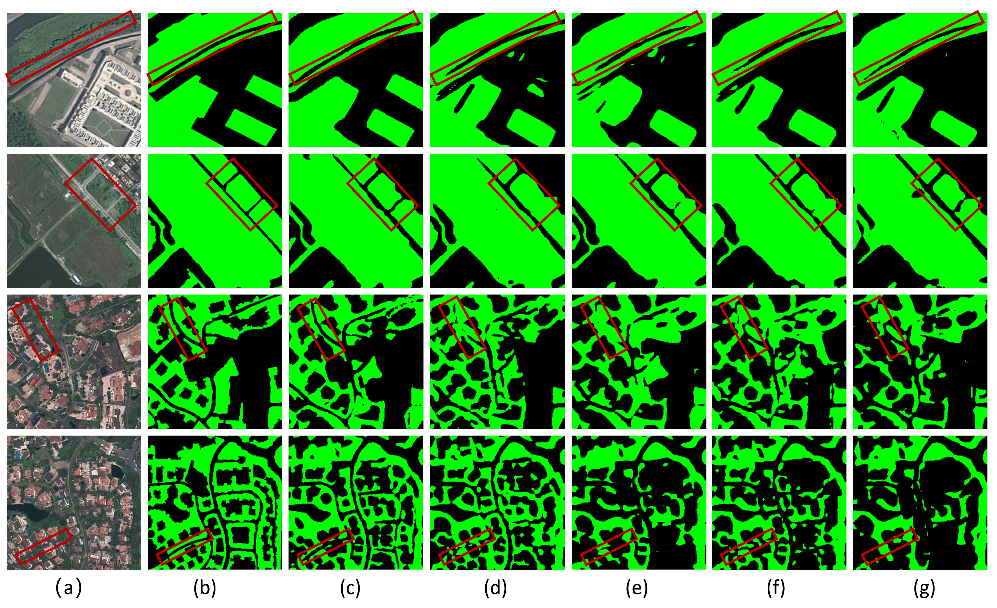
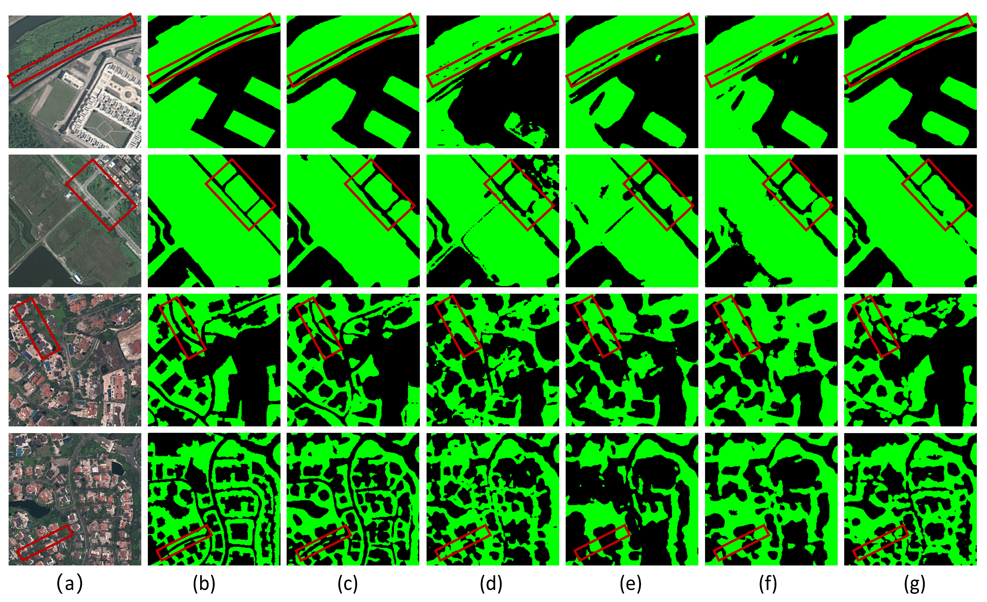
Figure 13 and Figure 14 presents representative visual comparisons on the UBGG dataset. In the first row of Figure 13 and Figure 14, numerous small green space patches are distributed around fragmented road networks, creating a highly heterogeneous spatial pattern. Several comparison methods exhibit varying degrees of confusion between green and non-green regions, resulting in incomplete boundary delineation or local misclassification. In contrast, HGRHDNet preserves the spatial extent of these dispersed green space patches more effectively and produces boundaries that are more consistent with the reference labels. The second to fourth rows of Figure 13 and Figure 14 depict scenes containing narrow road gaps interspersed among adjacent green spaces. Many competing methods partially fill these gaps or generate fragmented boundary structures, causing neighboring green spaces to merge. Benefiting from adaptive multi-scale feature fusion and enhanced boundary reconstruction, HGRHDNet maintains clearer separation between vegetation patches and preserves the continuity of narrow gap structures. The fifth row of Figure 13 and Figure 14 presents a particularly challenging example involving elongated and slender green space targets. Most comparison methods exhibit varying degrees of discontinuity and fragmentation when segmenting these structures. By contrast, HGRHDNet preserves the overall shape and continuity of the elongated green spaces more effectively, resulting in segmentation contours that more closely match the ground-truth annotations. Overall, the qualitative observations are highly consistent with the quantitative results in Table 5. The proposed HGRHDNet demonstrates superior capability in preserving fine-scale spatial structures, maintaining boundary integrity, and accurately extracting fragmented and irregular urban green spaces, thereby providing more reliable segmentation results in complex urban environments.

5. Discussion

The experimental results demonstrate that HGRHDNet consistently improves urban green space segmentation performance across datasets with different spatial resolutions and spectral characteristics. Although existing deep learning models have substantially advanced remote sensing image segmentation through multi-scale feature extraction, attention mechanisms, and contextual modeling, accurately delineating green space boundaries in complex urban environments remains challenging. Narrow vegetation belts, fragmented green space patches, building shadows, and heterogeneous urban backgrounds often lead to boundary ambiguity and the loss of fine spatial details. To address these challenges, the proposed HGRHDNet integrates a ConvNeXt-L encoder, HGRFD, and HFGDU. The HGRFD adaptively balances deep semantic information and shallow spatial details through dynamic feature weighting and residual feature propagation, while HFGDU enhances boundary reconstruction through high-frequency detail compensation and deformable feature alignment. The complementary effects of these modules contribute to improved boundary localization and more complete extraction of fine-scale green space structures.
To comprehensively evaluate the robustness of HGRHDNet, experiments were conducted on three datasets with distinct spatial resolutions and spectral characteristics, including WHDLD (2 m RGB imagery), UGS-1m (1 m RGB imagery), and UBGG (3 m NIR-Red-Green imagery). These datasets span spatial resolutions from 1 to 3 m and include both conventional RGB imagery and false-color imagery containing near-infrared information. The inclusion of the near-infrared band substantially enhances vegetation separability while introducing spectral characteristics that differ from those of standard RGB data. Consequently, the three datasets provide a rigorous benchmark for assessing model generalization across different imaging conditions. The three datasets cover different spatial resolutions and spectral characteristics of remote sensing images, providing sufficient validation for evaluating the adaptability and robustness of the model in diverse urban environments.
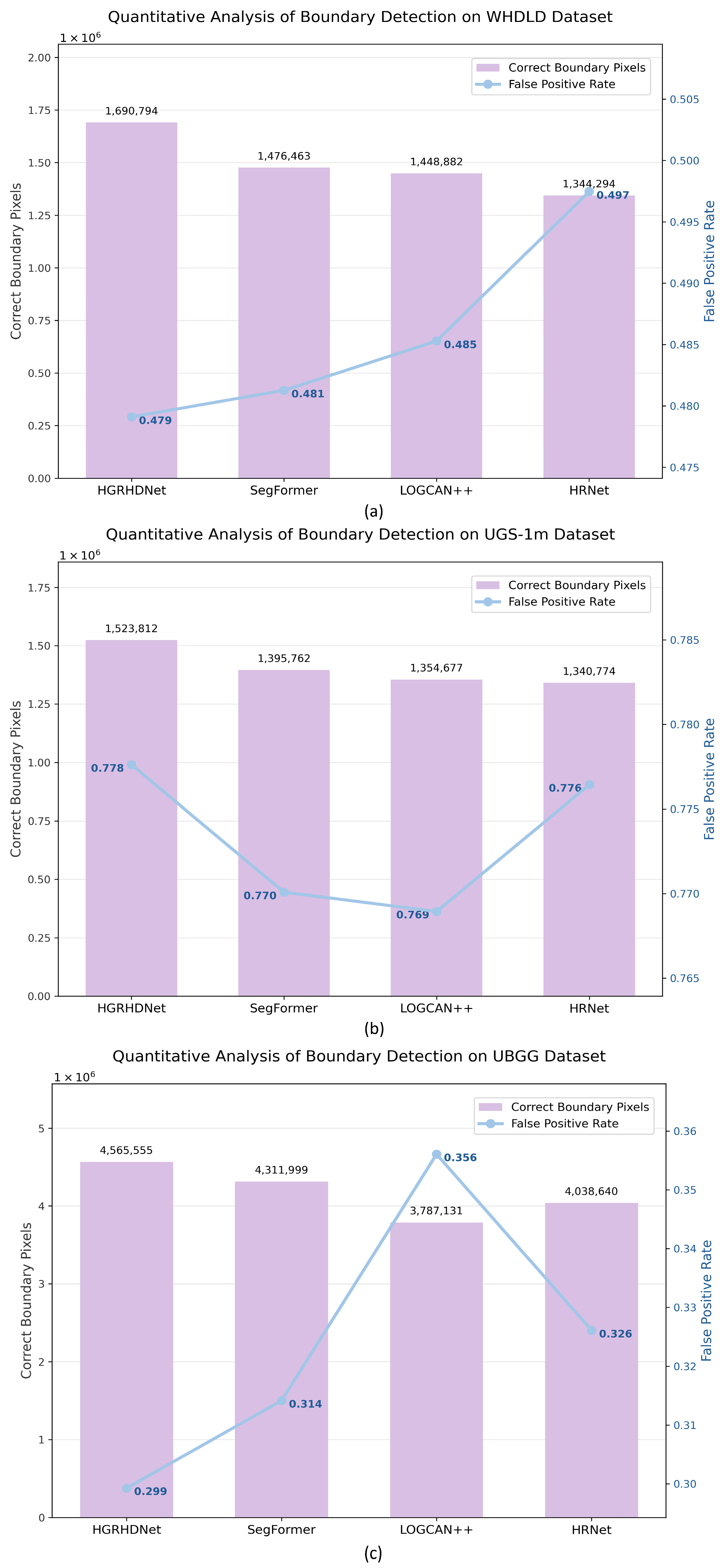
Comparative experiments against several representative segmentation models, including SegFormer, HRNet, UNetFormer, SACANet, DOCNet, and LOGCAN++, further demonstrate the effectiveness of the proposed architecture. Across all three datasets, HGRHDNet achieves the highest Boundary Intersection over Union (BIoU), indicating superior boundary delineation capability. Figure 15a presents the correct boundary pixels and false positive rate (the proportion of non-boundary pixels incorrectly classified as boundaries; lower values indicate fewer false boundary detections and more accurate localization) of the four best-performing models on the WHDLD. Among them, HGRHDNet achieves the highest correct boundary pixels (1,690,794) and the lowest false positive rate (0.479%), simultaneously leading in both edge detection quantity and boundary purity. On the UGS-1m dataset, the BIoU reaches 18.22%, which is 0.65% higher than that of UNetFormer. As shown in Figure 15b, HGRHDNet still captures the largest number of true green space boundary pixels (1,523,812). However, influenced by the model’s refined edge extraction strategy, which aims to fully preserve fragmented and irregular vegetation contours, a small number of irrelevant pixels are included in the predicted boundaries, resulting in a false positive rate (0.778%) slightly higher than those of SegFormer and LOGCAN++. In contrast, LOGCAN++ and SegFormer achieve lower false detection rates by compressing predicted boundaries and discarding numerous fine-grained ground object edges, but they suffer from pronounced omissions of true edges; their correct boundary detection counts are markedly lower than that of the proposed algorithm. On the UBGG dataset, the MIoU (93.08%) and BIoU (64.55%) are 0.49% and 1.64% higher than those of SegFormer, respectively. The results in Figure 15c demonstrate that HGRHDNet simultaneously obtains the highest correct boundary pixel count (4,565,555) and the lowest false positive rate (0.299%) on the UBGG dataset, balancing edge completeness and boundary prediction accuracy. All experimental results indicate that the proposed HGRHDNet model exhibits favorable robustness in delineating urban green space edges. Visual comparisons reveal that many existing methods encounter difficulties when segmenting narrow road gaps, elongated vegetation belts, fragmented green spaces, and shadow-affected regions. SegFormer [52] tends to generate blurred boundaries around fine structures, while SACANet and DOCNet [55,56] often exhibit incomplete extraction of slender green spaces and shadowed vegetation. Although UNetFormer incorporates global-local attention [53], its ability to recover fine boundary details remains limited. LOGCAN++ improves adaptability to scale variations through affine transformations [55], yet still experiences boundary localization errors in complex urban backgrounds. By contrast, HGRHDNet optimizes urban green space segmentation through the complementary designs of the HGRFD and HFGDU modules, addressing boundary ambiguity from two aspects, namely multi-scale feature fusion and boundary detail recovery. The HGRFD module adaptively adjusts the contributions of hierarchical features through dynamic weighting and employs residual connections to preserve shallow spatial details, thereby alleviating feature degradation during deep feature propagation and reducing boundary localization errors caused by insufficient multi-scale feature fusion. Meanwhile, the HFGDU module enhances the texture responses of green space boundaries through high-frequency detail compensation and dynamically adjusts the spatial discrepancies among multi-scale features using deformable alignment, facilitating more accurate reconstruction of boundary details. The synergistic interaction of the two modules endows HGRHDNet with the ability to accurately localize boundaries, isolate fine-scale green spaces, and comprehensively extract slender green space structures, even in complex background scenarios. In high-density urban areas characterized by complex green space morphology, fragmented patches, and dense inter-patch gaps, HGRHDNet demonstrates the most prominent performance. However, in regions where the spectral characteristics of vegetation and non-vegetation are highly similar, the model, relying solely on spectral and spatial information, struggles to effectively differentiate between the two, leading to a degradation in segmentation accuracy. Furthermore, the fine-grained boundary extraction strategy, while preserving fine contours completely, inevitably introduces a small number of false-positive boundaries. Nevertheless, the above results indicate that HGRHDNet is well adapted to the task requirements of urban green space extraction from different high-resolution remote sensing images, and effectively enhances the delineation capability of green space boundaries in complex urban scenarios. Compared with traditional segmentation results that focus solely on regional area consistency, the refined boundary predictions can more accurately preserve the morphologies of elongated, fragmented, and irregularly distributed urban green spaces, thereby providing more reliable foundational data for green space area statistics, spatial pattern analysis, urban ecological connectivity assessments, and fine-grained urban planning. The model is particularly applicable to high-density urban areas where buildings are dense and green-space patch sizes vary markedly, and can offer technical support for urban green space resource management and ecological space optimization.
Despite these promising results, several limitations remain. First, the current framework primarily exploits spectral and spatial information from single-date imagery and does not explicitly incorporate auxiliary vegetation-related descriptors, such as vegetation indices (e.g., NDVI) or phenological information. Consequently, confusion may still occur in areas where vegetation and non-vegetation classes exhibit similar spectral characteristics, such as sparsely vegetated land and exposed soil surfaces. Second, urban green spaces comprise diverse vegetation types, including lawns, shrubs, and trees, whose spectral and structural characteristics vary across seasons and growth stages. The use of single-temporal imagery may therefore limit the model’s ability to capture temporal variability in vegetation conditions.
Future research will focus on integrating multi-temporal remote sensing observations and vegetation-related auxiliary features into the proposed framework. The joint utilization of spectral, spatial, and temporal information may further enhance the discrimination of urban vegetation and improve segmentation robustness under complex environmental conditions. In addition, extending HGRHDNet to multi-class urban vegetation mapping and large-scale cross-city applications represents a promising direction for future investigation.

6. Conclusions

A novel deep learning framework, HGRHDNet, is developed for urban green space extraction from high-resolution remote sensing imagery. The proposed method addresses the challenges of boundary ambiguity and insufficient recovery of fine-scale structures commonly encountered in complex urban environments. Specifically, ConvNeXt-L was adopted as the encoder backbone to extract multi-level semantic features, while HGRFD and HFGDU were introduced to enhance multi-scale feature fusion, boundary localization, and high-frequency detail reconstruction. Extensive experiments were conducted on three datasets with different spatial resolutions and spectral characteristics, namely WHDLD, UGS-1m, and UBGG. The results demonstrate that HGRHDNet consistently achieves superior boundary delineation performance and attains the highest BIoU on all three datasets. Qualitative analyses further show that the proposed framework effectively preserves narrow gaps between adjacent green spaces, elongated vegetation structures, and fragmented green space patches, while reducing boundary erosion and misclassification in complex urban scenes. Overall, the proposed HGRHDNet provides a robust and effective solution for urban green space segmentation from high-resolution remote sensing imagery. The improved capability in preserving boundary integrity and fine-scale spatial details makes it particularly suitable for applications such as urban green space inventories, ecological assessment, and urban planning. Future work will focus on incorporating multi-temporal observations and vegetation-related auxiliary information to further improve segmentation accuracy and generalization performance under diverse environmental conditions while also pursuing lightweight solutions for urban green space boundary extraction.

Author Contributions

Conceptualization, W.M.; methodology, B.L.; validation, Z.S., B.L. and Y.M.; investigation, B.L.; data curation, B.L. and Y.M.; writing—original draft preparation, B.L.; writing—review and editing, B.L., Z.S. and X.D.; visualization, B.L.; supervision, X.D., Z.R. and Q.N.; project administration, Z.L., Z.S. and Z.R.; funding acquisition, W.M. and X.Z. All authors have read and agreed to the published version of the manuscript.

Funding

This research was funded by the “Open Competition” Project of Xiamen Science and Technology Bureau (Grant 3502Z20231038) and the Guiding Project of Natural Science Foundation of Fujian Province (Grant #2021H0026).

Data Availability Statement

The data used to support the results of this study are available from the respective authors upon request.

Acknowledgments

We are grateful to the anonymous reviewers for their valuable comments and suggestions, which have helped to improve this article.

Conflicts of Interest

The authors declare no conflicts of interest.

Abbreviations

The following abbreviations are used in this manuscript:
AbbreviationName
HGRFDHierarchical Gated Residual Fusion Decoder
HFGDUHigh-Frequency Guided Deformable Upsampler
BIoUBoundary Intersection over Union
NDVINormalized difference vegetation index
CNNConvolutional neural network
WHDLDWuhan Dense Labeling Dataset
UGS-1mUrban Green Space-1m
UBGGUrban Blue–Green–Grey
NIRNear-infrared
UBSUrban blue space
UGS-TreeUrban green space—tree
UGS-GrassUrban green space—grass
UISUrban impervious surface
MLPMultilayer Perceptron
Sum_NormSum normalization
HFDCHigh-Frequency Detail Compensation
DAFDeformable Alignment Fusion
MPAMean Pixel Accuracy
MIoUMean Intersection over Union
FWIoUFrequency Weighted Intersection over Union
MF1Mean F1-score

References

  1. Derdouri, A.; Murayama, Y.; Morimoto, T.; Wang, R.; Haji Mirza Aghasi, N. Urban Green Space in Transition: A Cross-Continental Perspective from Eight Global North and South Cities. Landsc. Urban Plan. 2025, 253, 105220. [Google Scholar] [CrossRef]
  2. Liu, Y.; Kwan, M.-P.; Wang, J. Analytically Articulating the Effect of Buffer Size on Urban Green Space Exposure Measures. Int. J. Geogr. Inf. Sci. 2025, 39, 255–276. [Google Scholar] [CrossRef]
  3. Han, Y.; He, J.; Liu, D.; Zhao, H.; Huang, J. Inequality in Urban Green Provision: A Comparative Study of Large Cities throughout the World. Sustain. Cities Soc. 2023, 89, 104229. [Google Scholar] [CrossRef]
  4. Xu, C.; Chen, G.; Huang, Q.; Su, M.; Rong, Q.; Yue, W.; Haase, D. Can Improving the Spatial Equity of Urban Green Space Mitigate the Effect of Urban Heat Islands? An Empirical Study. Sci. Total Environ. 2022, 841, 156687. [Google Scholar] [CrossRef] [PubMed]
  5. Staccione, A.; Essenfelder, A.H.; Bagli, S.; Mysiak, J. Connected Urban Green Spaces for Pluvial Flood Risk Reduction in the Metropolitan Area of Milan. Sustain. Cities Soc. 2024, 104, 105288. [Google Scholar] [CrossRef]
  6. Wilczyńska, A.; Myszka, I.; Bell, S.; Slapińska, M.; Janatian, N.; Schwerk, A. Exploring the Spatial Potential of Neglected or Unmanaged Blue Spaces in the City of Warsaw, Poland. Urban For. Urban Green. 2021, 64, 127252. [Google Scholar] [CrossRef]
  7. Chen, K.; Zhang, T.; Liu, F.; Zhang, Y.; Song, Y. How Does Urban Green Space Impact Residents’ Mental Health: A Literature Review of Mediators. Int. J. Environ. Res. Public Health 2021, 18, 11746. [Google Scholar] [CrossRef] [PubMed]
  8. Chen, Y.; Ge, Y.; Yang, G.; Wu, Z.; Du, Y.; Mao, F.; Liu, S.; Xu, R.; Qu, Z.; Xu, B.; et al. Inequalities of Urban Green Space Area and Ecosystem Services along Urban Center-Edge Gradients. Landsc. Urban Plan. 2022, 217, 104266. [Google Scholar] [CrossRef]
  9. Lin, Q.; Song, Y.; Zhang, Y.; Hao, J.L.; Wu, Z. Strategies for Restoring and Managing Ecological Corridors of Freshwater Ecosystem. Int. J. Environ. Res. Public Health 2022, 19, 15921. [Google Scholar] [CrossRef] [PubMed]
  10. Paudel, S.; States, S.L. Urban Green Spaces and Sustainability: Exploring the Ecosystem Services and Disservices of Grassy Lawns versus Floral Meadows. Urban For. Urban Green. 2023, 84, 127932. [Google Scholar] [CrossRef]
  11. Zhu, Z.; Li, J.; Chen, Z. Green Space Equity: Spatial Distribution of Urban Green Spaces and Correlation with Urbanization in Xiamen, China. Environ. Dev. Sustain. 2023, 25, 423–443. [Google Scholar] [CrossRef]
  12. Qin, H.; Zhou, W.; Yao, Y.; Wang, W. Individual Tree Segmentation and Tree Species Classification in Subtropical Broadleaf Forests Using UAV-Based LiDAR, Hyperspectral, and Ultrahigh-Resolution RGB Data. Remote Sens. Environ. 2022, 280, 113143. [Google Scholar] [CrossRef]
  13. Neyns, R.; Canters, F. Mapping of Urban Vegetation with High-Resolution Remote Sensing: A Review. Remote Sens. 2022, 14, 1031. [Google Scholar] [CrossRef]
  14. Sicard, P.; Coulibaly, F.; Lameiro, M.; Araminiene, V.; De Marco, A.; Sorrentino, B.; Anav, A.; Manzini, J.; Hoshika, Y.; Moura, B.B.; et al. Object-Based Classification of Urban Plant Species from Very High-Resolution Satellite Imagery. Urban For. Urban Green. 2023, 81, 127866. [Google Scholar] [CrossRef]
  15. Huang, Y.; Wang, L.; Zhao, P.; Zhao, Y.; Yang, Q.; Du, Y.; Ling, F. Deep Learning in Urban Green Space Extraction in Remote Sensing: A Comprehensive Systematic Review. Int. J. Remote Sens. 2024, 46, 1117–1150. [Google Scholar] [CrossRef]
  16. Xue, W.; Feng, L.; Yang, J.; Xu, Y.; Ho, H.C.; Luo, R.; Menenti, M.; Wong, M.S. Retrieval of Vegetation Indices and Vegetation Fraction in Highly Compact Urban Areas: A 3D Radiative Transfer Approach. Remote Sens. 2025, 17, 143. [Google Scholar] [CrossRef]
  17. Hu, J.; Chen, W.; Li, X.; He, X. Roof Confusion Removal for Accurate Vegetation Extraction in the Urban Environment. In Proceedings of the 2008 International Workshop on Earth Observation and Remote Sensing Applications, Beijng, China, 30 June 2008; pp. 1–7. [Google Scholar]
  18. Wang, L.; Sousa, W.P.; Gong, P. Integration of Object-Based and Pixel-Based Classification for Mapping Mangroves with IKONOS Imagery. Int. J. Remote Sens. 2004, 25, 5655–5668. [Google Scholar] [CrossRef]
  19. Gao, Y.; Mas, J. A Comparison of the Performance of Pixel Based and Object Based Classifications over Images with Various Spatial Resolutions. Online J. Earth Sci. 2008, 2, 27–35. [Google Scholar]
  20. Bayazit, M.; Dönmez, C.; Berberoglu, S. Assessing the Efficiency of Pixel-Based and Object-Based Image Classification Using Deep Learning in an Agricultural Mediterranean Plain. Environ. Monit. Assess. 2025, 197, 155. [Google Scholar] [CrossRef] [PubMed]
  21. Zhong, Y.; Zhao, J.; Zhang, L. A Hybrid Object-Oriented Conditional Random Field Classification Framework for High Spatial Resolution Remote Sensing Imagery. IEEE Trans. Geosci. Remote Sens. 2014, 52, 7023–7037. [Google Scholar] [CrossRef]
  22. Hao, S.; Cui, Y.; Wang, J. Segmentation Scale Effect Analysis in the Object-Oriented Method of High-Spatial-Resolution Image Classification. Sensors 2021, 21, 7935. [Google Scholar] [CrossRef] [PubMed]
  23. Shelhamer, E.; Long, J.; Darrell, T. Fully Convolutional Networks for Semantic Segmentation. IEEE Trans. Pattern Anal. Mach. Intell. 2017, 39, 640–651. [Google Scholar] [CrossRef] [PubMed]
  24. Ronneberger, O.; Fischer, P.; Brox, T. U-Net: Convolutional Networks for Biomedical Image Segmentation. In Proceedings of the Medical Image Computing and Computer-Assisted Intervention—MICCAI 2015, Munich, Germany, 5 October 2015; pp. 234–241. [Google Scholar]
  25. Chen, L.-C.; Zhu, Y.; Papandreou, G.; Schroff, F.; Adam, H. Encoder-Decoder with Atrous Separable Convolution for Semantic Image Segmentation. In Proceedings of the European Conference on Computer Vision (ECCV), Munich, Germany, 8–14 September 2018; pp. 833–851. [Google Scholar]
  26. Cheng, Y.; Wang, W.; Ren, Z.; Zhao, Y.; Liao, Y.; Ge, Y.; Wang, J.; He, J.; Gu, Y.; Wang, Y.; et al. Multi-Scale Feature Fusion and Transformer Network for Urban Green Space Segmentation from High-Resolution Remote Sensing Images. Int. J. Appl. Earth Obs. Geoinf. 2023, 124, 103514. [Google Scholar] [CrossRef]
  27. Wang, W.; Cheng, Y.; Ren, Z.; He, J.; Zhao, Y.; Wang, J.; Zhang, W. A Novel Hybrid Method for Urban Green Space Segmentation from High-Resolution Remote Sensing Images. Remote Sens. 2023, 15, 5472. [Google Scholar] [CrossRef]
  28. Wu, Y.; Zhang, M. Swin-CFNet: An Attempt at Fine-Grained Urban Green Space Classification Using Swin Transformer and Convolutional Neural Network. IEEE Geosci. Remote Sens. Lett. 2024, 21, 2503405. [Google Scholar] [CrossRef]
  29. Chen, K.; Wang, Y.; Huang, C.; Wang, J.; Li, S.L.; Guan, H.; Ma, L. GreenNet: A Dual-Encoder Network for Urban Green Space Classification Using High-Resolution Remotely Sensed Images. Int. J. Appl. Earth Obs. Geoinf. 2025, 142, 104709. [Google Scholar] [CrossRef]
  30. Yu, M.; He, L.; Shen, Z.; Lv, M. STRD-Net: A Dual-Encoder Semantic Segmentation Network for Urban Green Space Extraction. IEEE Trans. Geosci. Remote Sens. 2024, 62, 4413913. [Google Scholar] [CrossRef]
  31. Liu, H.; Su, X.; Shen, X.; Zhou, X. MSNet: Self-Supervised Multiscale Network With Enhanced Separation Training for Hyperspectral Anomaly Detection. IEEE Trans. Geosci. Remote Sens. 2024, 62, 5520313. [Google Scholar] [CrossRef]
  32. Chen, J.; Huang, Z.; Wang, F.; Wen, Z.; Zhu, J.; Zhou, G. Distribution-Aware CLIP-Adapter with Fine-Grained Text for Few-Shot Fine-Grained Classification. Remote Sens. 2026, 18, 1813. [Google Scholar] [CrossRef]
  33. Li, R.; Zheng, S.; Duan, C.; Wang, L.; Zhang, C. Land Cover Classification from Remote Sensing Images Based on Multi-Scale Fully Convolutional Network. Geo-Spat. Inf. Sci. 2022, 25, 278–294. [Google Scholar] [CrossRef]
  34. Shi, Q.; Liu, M.; Marinoni, A.; Liu, X. UGS-1m: Fine-Grained Urban Green Space Mapping of 31 Major Cities in China Based on the Deep Learning Framework. Earth Syst. Sci. Data 2023, 15, 555–577. [Google Scholar] [CrossRef]
  35. Xu, Z.; Zhao, S. Fine-Grained Urban Blue-Green-Gray Landscape Dataset for 36 Chinese Cities Based on Deep Learning Network. Sci. Data 2024, 11, 266. [Google Scholar] [CrossRef] [PubMed]
  36. He, K.; Zhang, X.; Ren, S.; Sun, J. Deep Residual Learning for Image Recognition. In Proceedings of the 2016 IEEE Conference on Computer Vision and Pattern Recognition (CVPR), Las Vegas, NV, USA, 26 June 2016; pp. 770–778. [Google Scholar]
  37. Ding, X.; Zhang, X.; Han, J.; Ding, G. Scaling Up Your Kernels to 31 × 31: Revisiting Large Kernel Design in CNNs. In Proceedings of the 2022 IEEE/CVF Conference on Computer Vision and Pattern Recognition (CVPR), New Orleans, LA, USA, 19 June 2022; pp. 1–13. [Google Scholar]
  38. Liu, Z.; Mao, H.; Wu, C.-Y.; Feichtenhofer, C.; Darrell, T.; Xie, S. A ConvNet for the 2020s. In Proceedings of the 2022 IEEE/CVF Conference on Computer Vision and Pattern Recognition (CVPR), New Orleans, LA, USA, 19 June 2022; pp. 11966–11976. [Google Scholar]
  39. Dosovitskiy, A.; Beyer, L.; Kolesnikov, A.; Weissenborn, D.; Zhai, X.; Unterthiner, T.; Dehghani, M.; Minderer, M.; Heigold, G.; Gelly, S.; et al. An Image Is Worth 16x16 Words: Transformers for Image Recognition at Scale. In Proceedings of the 9th International Conference on Learning Representations (ICLR), Virtual, Austria, 4 May 2021; pp. 1–21. [Google Scholar]
  40. Lin, S.; Lyu, P.; Liu, D.; Tang, T.; Liang, X.; Song, A.; Chang, X. MLP Can Be A Good Transformer Learner. In Proceedings of the 2024 IEEE/CVF Conference on Computer Vision and Pattern Recognition (CVPR), Seattle, WA, USA, 17 June 2024; pp. 1–10. [Google Scholar]
  41. Liu, S.; Qi, L.; Qin, H.; Shi, J.; Jia, J. Path Aggregation Network for Instance Segmentation. In Proceedings of the 2018 IEEE/CVF Conference on Computer Vision and Pattern Recognition (CVPR), Salt Lake City, UT, USA, 18 June 2018; pp. 1–10. [Google Scholar]
  42. Wang, J.; Sun, K.; Cheng, T.; Jiang, B.; Deng, C.; Zhao, Y.; Liu, D.; Mu, Y.; Tan, M.; Wang, X.; et al. Deep High-Resolution Representation Learning for Visual Recognition. IEEE Trans. Pattern Anal. Mach. Intell. 2021, 43, 3349–3364. [Google Scholar] [CrossRef] [PubMed]
  43. Chang-lai, G.; Cong, L.; Dong-tao, Y. A Novel Bilinear Interpolation Method Based on Edge Direction. Laser Infrared 2010, 40, 788–791. [Google Scholar]
  44. Panda, J.; Meher, S. An Improved Image Interpolation Technique Using OLA E-Spline. Egypt. Inform. J. 2022, 23, 159–172. [Google Scholar] [CrossRef]
  45. Xiao, T.; Wang, Q.; Lu, P.; Huang, T.; Tong, X.; Atkinson, P.M. Crowd Detection Using Very-Fine-Resolution Satellite Imagery. ISPRS J. Photogramm. Remote Sens. 2026, 232, 787–809. [Google Scholar] [CrossRef]
  46. Albattah, W.; Khan, R.U. Impact of Imbalanced Features on Large Datasets. Front. Big Data 2025, 8, 1455442. [Google Scholar] [CrossRef] [PubMed]
  47. Kim, J.; Lee, Y.-K.; Choi, C.-S.; Fereshtenejad, S.; Song, J.-J. Scanline Intersection Similarity: A Similarity Metric for Joint Trace Maps. Comput. Geosci. 2023, 175, 105358. [Google Scholar] [CrossRef]
  48. Zhao, H.; Luo, P.; Cui, W.; Xia, C.; Xu, X.; Feng, Z.; Chen, J.; Wang, J.; Xun, W.; Chen, C. Geographical Scenario Knowledge-Informed Graph Structure Attention for Image Segmentation. IEEE Trans. Geosci. Remote Sens. 2025, 63, 4401016. [Google Scholar] [CrossRef]
  49. Maxwell, A.E.; Warner, T.A.; Guillén, L.A. Accuracy Assessment in Convolutional Neural Network-Based Deep Learning Remote Sensing Studies—Part 1: Literature Review. Remote Sens. 2021, 13, 2450. [Google Scholar] [CrossRef]
  50. Wang, J.; Zheng, C.; Fu, H.; Zhao, Y.; Dai, Q.; Huang, X.; Xie, J.; Wang, L. Object Based Markov Random Field Model for Hierarchical Semantic Segmentation of Remote Sensing Imagery. Int. J. Digit. Earth 2025, 18, 2521795. [Google Scholar] [CrossRef]
  51. Cheng, B.; Girshick, R.; Dollar, P.; Berg, A.C.; Kirillov, A. Boundary IoU: Improving Object-Centric Image Segmentation Evaluation. In Proceedings of the 2021 IEEE/CVF Conference on Computer Vision and Pattern Recognition (CVPR), Nashville, TN, USA, 19 June 2021; pp. 15329–15337. [Google Scholar]
  52. Xie, E.; Wang, W.; Yu, Z.; Anandkumar, A.; Alvarez, J.M.; Luo, P. SegFormer: Simple and Efficient Design for Semantic Segmentation with Transformers. In Proceedings of the 35th Conference on Neural Information Processing Systems (NeurIPS), Virtual, Canada, 6 December 2021; pp. 1–18. [Google Scholar]
  53. Wang, L.; Li, R.; Zhang, C.; Fang, S.; Duan, C.; Meng, X.; Atkinson, P.M. UNetFormer: A UNet-like Transformer for Efficient Semantic Segmentation of Remote Sensing Urban Scene Imagery. ISPRS J. Photogramm. Remote Sens. 2022, 190, 196–214. [Google Scholar] [CrossRef]
  54. Ma, X.; Ma, M.; Hu, C.; Song, Z.; Zhao, Z.; Feng, T.; Zhang, W. Log-Can: Local-Global Class-Aware Network For Semantic Segmentation of Remote Sensing Images. In Proceedings of the ICASSP 2023—2023 IEEE International Conference on Acoustics, Speech and Signal Processing (ICASSP), Rhodes, Greece, 4 June 2023; pp. 1–5. [Google Scholar]
  55. Ma, X.; Che, R.; Hong, T.; Ma, M.; Zhao, Z.; Feng, T.; Zhang, W. SACANet: Scene-Aware Class Attention Network for Semantic Segmentation of Remote Sensing Images. In Proceedings of the 2023 IEEE International Conference on Multimedia and Expo (ICME), Brisbane, Australia, 10 July 2023; pp. 828–833. [Google Scholar]
  56. Ma, X.; Che, R.; Wang, X.; Ma, M.; Wu, S.; Feng, T.; Zhang, W. DOCNet: Dual-Domain Optimized Class-Aware Network for Remote Sensing Image Segmentation. IEEE Geosci. Remote Sens. Lett. 2024, 21, 2500905. [Google Scholar] [CrossRef]
  57. Ma, X.; Lian, R.; Wu, Z.; Guo, H.; Yang, F.; Ma, M.; Wu, S.; Du, Z.; Zhang, W.; Song, S. LOGCAN++: Adaptive Local-Global Class-Aware Network for Semantic Segmentation of Remote Sensing Images. IEEE Trans. Geosci. Remote Sens. 2025, 63, 4404216. [Google Scholar] [CrossRef]
Figure 1. Overview of the WHDLD. (a) Example of WHDLD; (b) the pixel distribution of the WHDLD; (c) the pixel distribution of the different subsets.
Remotesensing 18 02620 g001
Figure 2. Overview of the UGS-1m dataset. (a) Example of UGS-1m dataset; (b) the pixel distribution of the UGS-1m dataset; (c) the pixel distribution of the different subsets.
Remotesensing 18 02620 g002
Figure 3. Overview of the UBGG dataset. (a) Example of UBGG dataset; (b) the pixel distribution of the UBGG dataset; (c) the pixel distribution of the different subsets.
Remotesensing 18 02620 g003
Figure 4. HGRHDNet structure.
Remotesensing 18 02620 g004
Figure 5. (a) ResNet backbone; (b) ConvNeXt backbone.
Remotesensing 18 02620 g005
Figure 6. Hierarchical Gated Residual Fusion Decoder (HGRFD).
Remotesensing 18 02620 g006
Figure 7. High-Frequency Guided Deformable Upsampler (HFGDU). HFDC represents High-Frequency Detail Compensation; DAF refers to Deformable Alignment Fusion.
Remotesensing 18 02620 g007
Figure 8. WHDLD ablation experiment visualization results. (a) Input image; (b) label; (c) ConvNeXt-L + HGRFD (HFGDU); (d) ConvNeXt-L + HGRFD (Bilinear); (e) ConvNeXt-L + MultiScale_Fusion_decoder; (f) ConvNeXt-L + Simple_decoder.
Remotesensing 18 02620 g008
Figure 9. Comparison experimental visualization results of WHDLD. (a) Input image; (b) label; (c) HGRHDNet; (d) DOCNet; (e) SACANet; (f) LOGCAN++; (g) UNetFormer.
Remotesensing 18 02620 g009
Figure 10. Comparison experimental visualization results of WHDLD. (a) Input image; (b) label; (c) HGRHDNet; (d) LogCan; (e) HRNet; (f) Swin-CFNet; (g) SegFormer.
Remotesensing 18 02620 g010
Figure 11. Comparison experimental visualization results of UGS-1m. (a) Input image; (b) label; (c) HGRHDNet; (d) UNetFormer; (e) DOCNet; (f) SACANet; (g) LOGCAN++.
Remotesensing 18 02620 g011
Figure 12. Comparison experimental visualization results of UGS-1m. (a) Input image; (b) label; (c) HGRHDNet; (d) LogCan; (e) HRNet; (f) Swin-CFNet; (g) SegFormer.
Remotesensing 18 02620 g012
Figure 13. Comparison experimental visualization results of UBGG. (a) Input image; (b) label; (c) HGRHDNet; (d) SegFormer; (e) LOGCAN++; (f) HRNet; (g) UNetFormer.
Remotesensing 18 02620 g013
Figure 14. Comparison experimental visualization results of UBGG. (a) Input image; (b) label; (c) HGRHDNet; (d) DOCNet; (e) SACANet; (f) LogCan; (g) Swin-CFNet.
Remotesensing 18 02620 g014
Figure 15. Quantitative analysis of boundary detection on three datasets. (a) Quantitative Analysis of Boundary Detection on WHDLD Dataset; (b) Quantitative Analysis of Boundary Detection on UGS-1m Dataset; (c) Quantitative Analysis of Boundary Detection on UBGG Dataset.
Remotesensing 18 02620 g015
Table 1. Ablation experiments on the WHDLD.
ModelMPA
(%)
MIoU
(%)
MF1
(%)
Kappa
(%)
BIoU
(%)
ConvNeXt-L + Simple_decoder91.1583.7491.1582.3032.82
ConvNeXt-L + MultiScale_Fusion_decoder91.8784.9691.8783.7340.23
ConvNeXt-L + HGRFD_decoder (Bilinear)92.0085.1892.0084.0042.14
ConvNeXt-L + HGRFD_decoder (HFGDU)92.2285.5692.2284.4343.82
Table 2. Parameter count and FLOPs of the compared models.
ModelParams (M)FLOPs (G)
UnetFormer (2022)11.682.93
LOGCAN++ (2025)25.199.32
SACANet (2023)30.2114.13
LogCan (2023)30.9112.39
DOCNet (2024)39.1149.28
Swin-CFNet (2024)66.7516.67
HRNet (2019)70.3540.58
SegFormer (2021)84.6029.3
HGRHDNet200.09107.31
Table 3. Results of comparison experiments on WHDLD.
ModelMPA (%)MIoU (%)FWIoU (%)MF1 (%)Kappa (%)BIoU (%)
d = 5d = 3
SegFormer (2021)88.7979.9079.9388.8277.6534.5421.29
Swin-CFNet (2024)89.5781.1780.9889.4879.1931.1718.97
HRNet (2019)91.1383.7385.4991.0682.1236.1221.78
LogCan (2023)91.7984.7984.8091.7783.5439.9524.55
UnetFormer (2022)91.7884.8184.8391.7883.5740.4826.40
LOGCAN++ (2025)91.8684.9484.9591.8583.7139.9324.51
SACANet (2023)92.1985.4885.5092.1784.3442.0025.99
DOCNet (2024)92.2085.5785.5992.2284.4541.4526.48
HGRHDNet92.2285.5685.5692.2284.4343.8228.38
The highest value for each metric across all compared models is highlighted in green.
Table 4. Results of comparison experiments on UGS-1m.
ModelMPA (%)MIoU (%)FWIoU (%)MF1 (%)Kappa (%)BIoU (%)
d = 5d = 3
SegFormer (2021)77.7163.8965.2177.7855.5614.256.25
Swin-CFNet (2024)79.8264.9065.6678.6557.5914.616.48
HRNet (2019)79.7566.4367.6279.6959.3814.926.60
LogCan (2023)81.8268.9870.0181.5463.1016.747.50
LOGCAN++ (2025)81.9669.3570.4181.7963.5916.397.35
SACANet (2023)82.2569.5270.5281.9363.8717.027.57
DOCNet (2024)82.2069.5670.5981.9563.9116.987.82
UNetFormer (2022)82.1569.6570.8381.9863.9717.577.89
HGRHDNet82.2269.6470.6782.0064.0118.228.20
The highest value for each metric across all compared models is highlighted in green.
Table 5. Results of comparison experiments on UBGG.
ModelMPA (%)MIoU (%)FWIoU (%)MF1 (%)Kappa (%)BIoU (%)
d = 5d = 3
SegFormer (2021)92.7786.4686.5092.7485.4845.9526.95
Swin-CFNet (2024)93.9588.6188.6493.9687.9250.2630.69
HRNet (2019)94.4789.5289.5494.4788.9351.9932.24
LogCan (2023)94.4789.5389.5694.4888.9552.9133.14
LOGCAN++ (2025)94.6589.8189.8494.6389.2752.7132.71
SACANet (2023)95.9092.1692.2095.9391.8560.3539.82
DOCNet (2024)95.4391.2991.3195.4490.8956.7836.19
UNetFormer (2022)96.1692.5992.6196.1592.3162.9141.70
HGRHDNet96.4393.0893.0996.4192.8364.5544.85
The highest value for each metric across all compared models is highlighted in green.
Disclaimer/Publisher’s Note: The statements, opinions and data contained in all publications are solely those of the individual author(s) and contributor(s) and not of MDPI and/or the editor(s). MDPI and/or the editor(s) disclaim responsibility for any injury to people or property resulting from any ideas, methods, instructions or products referred to in the content.