Enhancing Earthquake-Induced Landslide Susceptibility Mapping Through Integration of Climatological Soil Moisture: A Hybrid CNN–Swin Transformer Approach

 ,
,  ,
,  ,
,  ,
,
Highlights
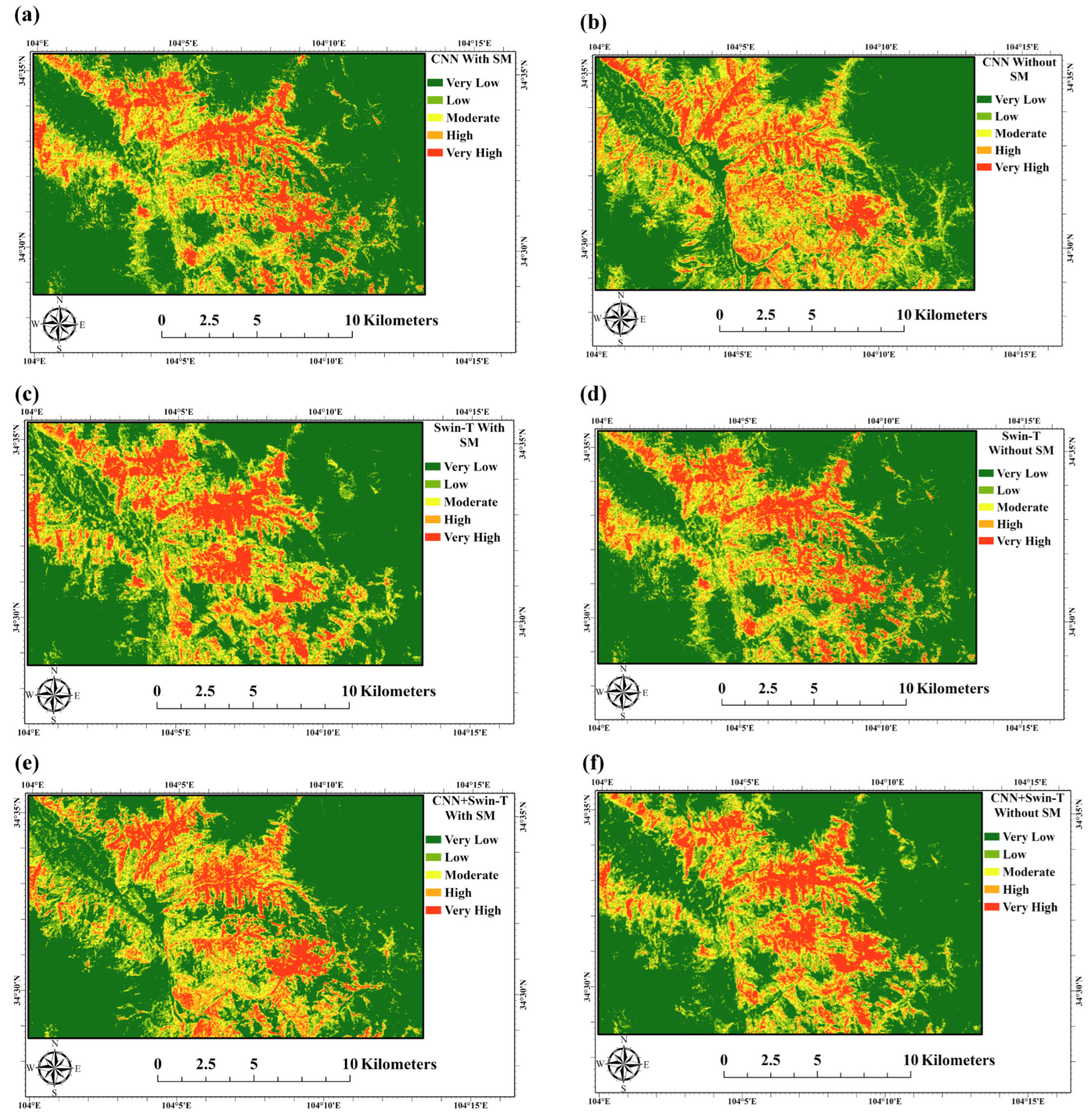
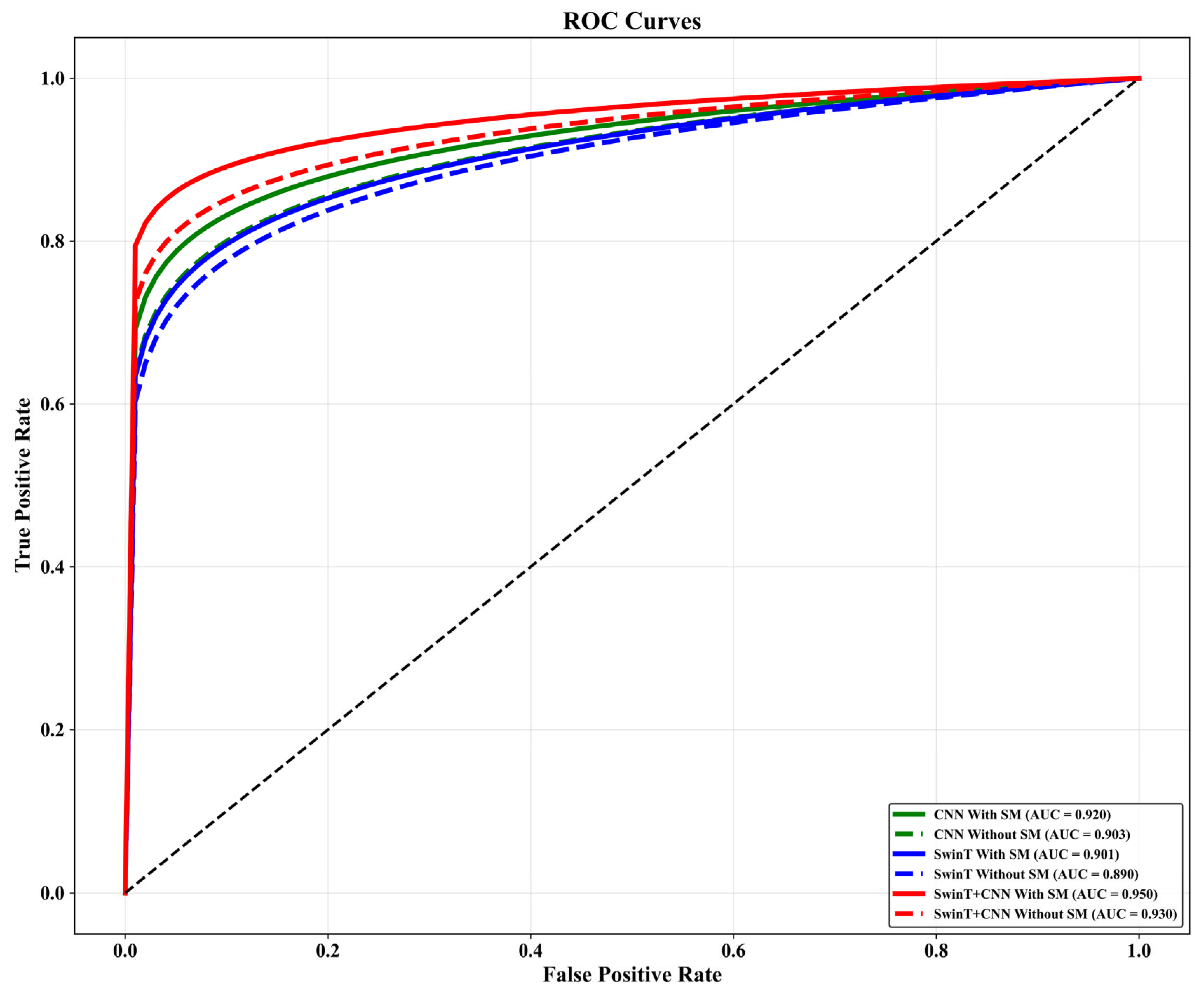
- A Hybrid CNN-SwinT model achieved high accuracy in earthquake-induced landslide susceptibility mapping and outperformed individual deep learning models.
- Integrating long-term mean soil moisture as a static hydrological conditioning factor improved model performance of earthquake-induced landslides.
- Climatological Soil moisture information should be considered as complementary hydrological conditioning factors to improve the reliability of hazard mapping.
- The proposed framework provides an effective approach for high-resolution landslide susceptibility mapping and risk management in seismically active areas.
Abstract
1. Introduction
- Methodological innovation: Developed a novel hybrid CNN-SwinT deep learning framework that successfully integrates localized convolutional feature extraction with attention-based, long-range spatial dependency modeling for LSM.
- Hydrological integration gap-filling: Pioneered the application of remotely sensed long-term spatial soil moisture data as a static hydrological conditioning factor within earthquake-induced LSM, addressing a critical oversight in conventional seismic hazard frameworks.
- Controlled Empirical Validation: Quantified the predictive significance of soil moisture through a controlled, dual-scenario comparative analysis (modeled with and without hydrological data) under uniform experimental conditions, demonstrating a marked improvement in classification accuracy and spatial consistency.
2. Materials and Methods
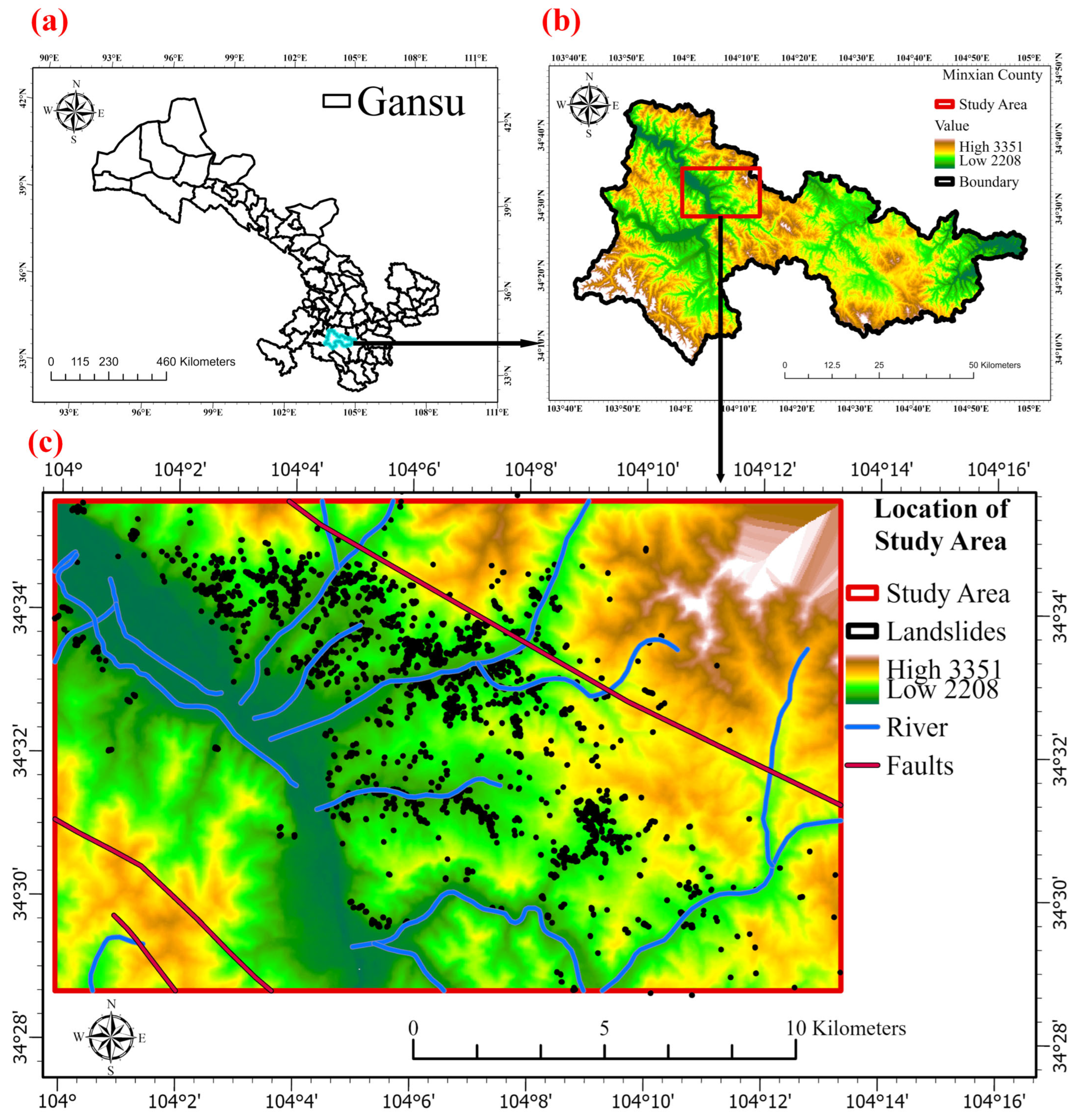
2.1. Study Area and Created Landslide Inventory Map
2.2. Landslide Causative Factors
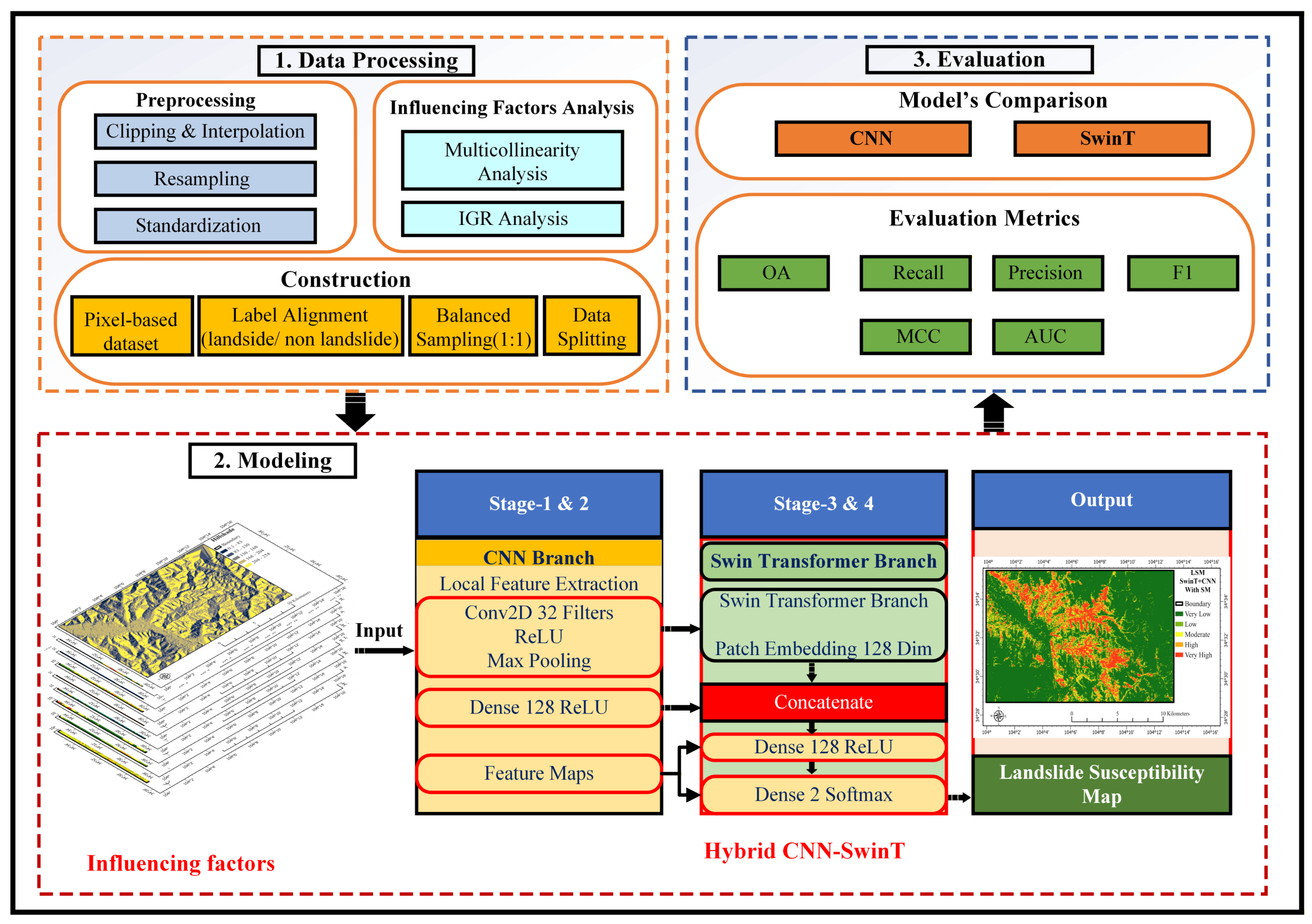
2.3. Methodology and Modeling Procedure
2.3.1. Data Processing, Factor Evaluation, and Multicollinearity Test
2.3.2. Information Gain Ratio (IGR) Analysis
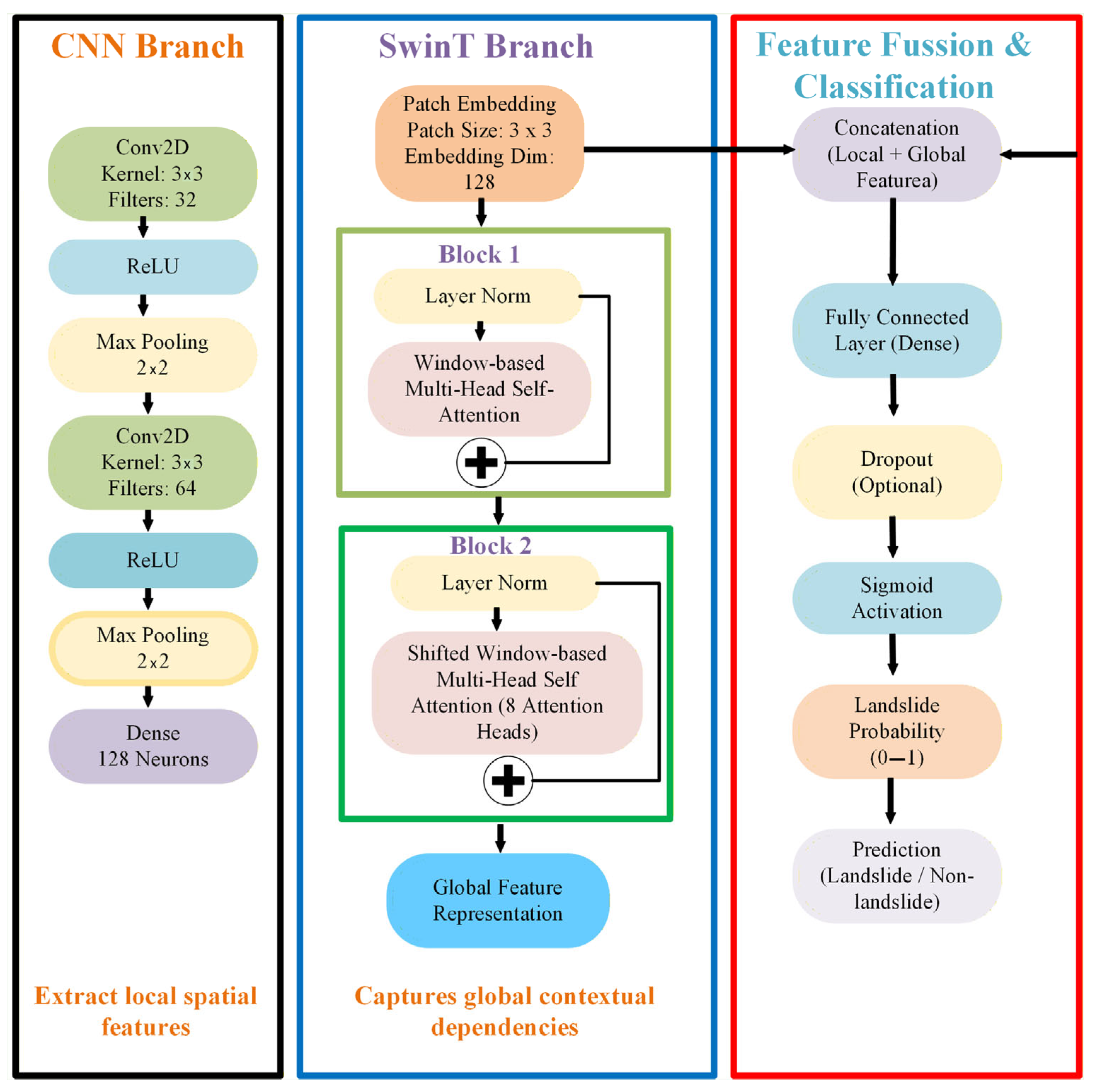
2.3.3. Optimal Model and Experimental Hyperparameter Setting
3. Results
3.1. Multicollinearity Analysis
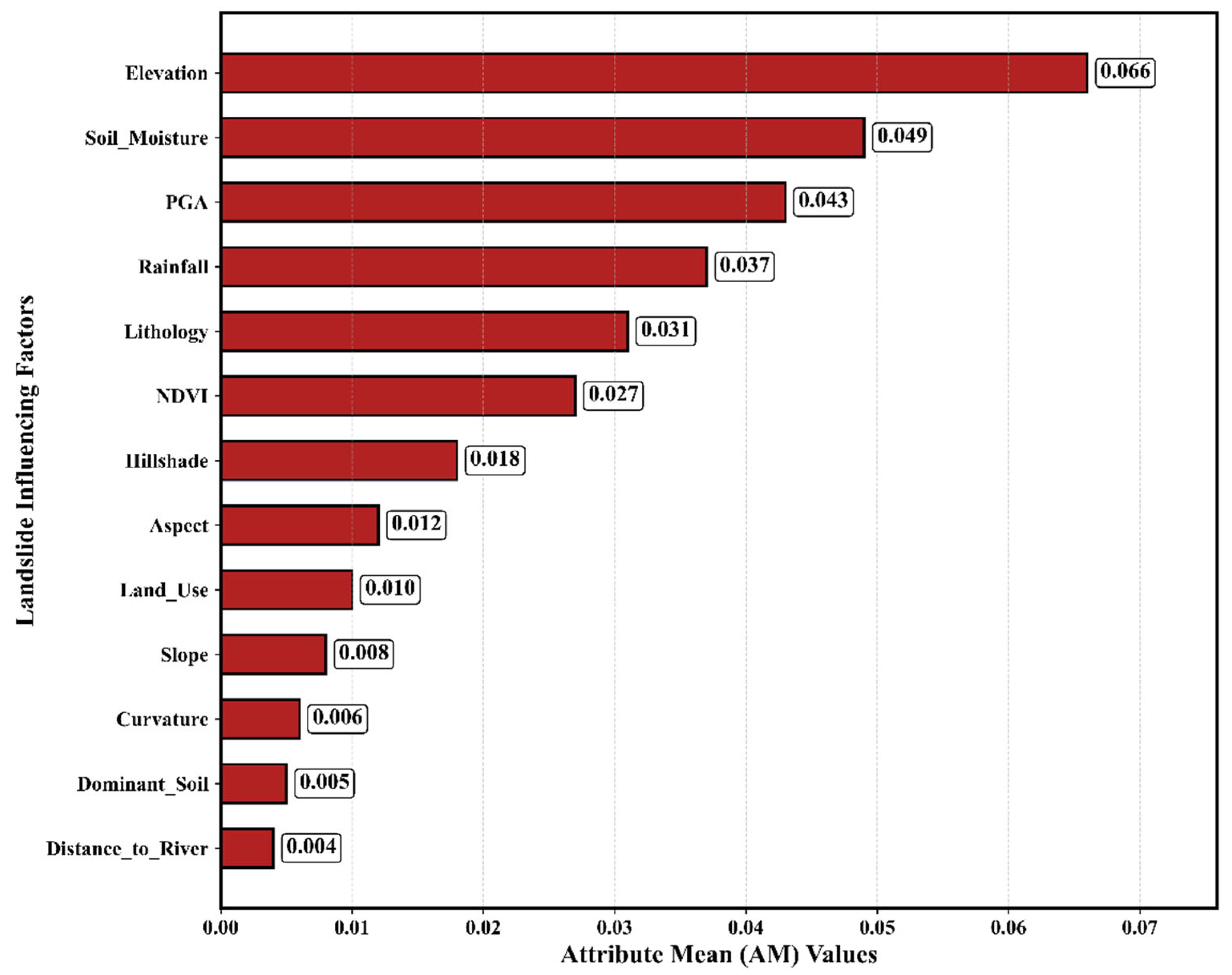
3.2. AM-Based Importance Analysis
3.3. Comparison of Generated LSM
3.4. Model Evaluation
4. Discussion
5. Conclusions
Author Contributions
Funding
Data Availability Statement
Acknowledgments
Conflicts of Interest
References
- Kamal, M.; Zhang, B.; Cao, J.; Zhang, X.; Chang, J. Comparative study of artificial neural network and random forest model for susceptibility assessment of landslides induced by earthquake in the Western Sichuan Plateau, China. Sustainability 2022, 14, 13739. [Google Scholar] [CrossRef] [Scilit]
- Abbaszadeh Shahri, A.; Maghsoudi Moud, F. Landslide susceptibility mapping using hybridized block modular intelligence model. Bull. Eng. Geol. Environ. 2021, 80, 267–284. [Google Scholar] [CrossRef] [Scilit]
- Li, J.; Wang, W.; Han, Z.; Li, Y.; Chen, G. Exploring the impact of multitemporal DEM data on the susceptibility mapping of landslides. Appl. Sci. 2020, 10, 2518. [Google Scholar] [CrossRef] [Scilit]
- Reichenbach, P.; Rossi, M.; Malamud, B.D.; Mihir, M.; Guzzetti, F. A review of statistically-based landslide susceptibility models. Earth-Sci. Rev. 2018, 180, 60–91. [Google Scholar] [CrossRef] [Scilit]
- Berti, M.; Corsini, A.; Daehne, A. Comparative analysis of surface roughness algorithms for the identification of active landslides. Geomorphology 2013, 182, 1–18. [Google Scholar] [CrossRef] [Scilit]
- Booth, A.M.; Roering, J.J.; Perron, J.T. Automated landslide mapping using spectral analysis and high-resolution topographic data: Puget Sound lowlands, Washington, and Portland Hills, Oregon. Geomorphology 2009, 109, 132–147. [Google Scholar] [CrossRef] [Scilit]
- Carrara, A. Multivariate models for landslide hazard evaluation. Math. Geol. 1983, 15, 403–426. [Google Scholar] [CrossRef] [Scilit]
- Dou, J.; Yunus, A.P.; Merghadi, A.; Shirzadi, A.; Nguyen, H.; Hussain, Y.; Avtar, R.; Chen, Y.; Pham, B.T.; Yamagishi, H. Different sampling strategies for predicting landslide susceptibilities are deemed less consequential with deep learning. Sci. Total Environ. 2020, 720, 137320. [Google Scholar] [CrossRef] [Scilit] [PubMed]
- Volpe, E.; Ciabatta, L.; Salciarini, D.; Camici, S.; Cattoni, E.; Brocca, L. The impact of probability density functions assessment on model performance for slope stability analysis. Geosciences 2021, 11, 322. [Google Scholar] [CrossRef] [Scilit]
- Peiro, Y.; Volpe, E.; Ciabatta, L.; Cattoni, E. High resolution precipitation and soil moisture data integration for landslide susceptibility mapping. Geosciences 2024, 14, 330. [Google Scholar] [CrossRef] [Scilit]
- Guo, Z.; Zeng, T.; Zhang, Y.; Yu, W.; Wang, L.; Guo, Z.; Glade, T. A novel hybrid model integrating high resolution remote sensing and stacking ensemble techniques for landslide susceptibility mapping: Application to event-based landslide inventory. Geomorphology 2025, 486, 109886. [Google Scholar] [CrossRef] [Scilit]
- Li, Y.; Rangarajan, S.; Cheng, Y.; Rahardjo, H.; Satyanaga, A. Random forest-based prediction of shallow slope stability considering spatiotemporal variations in unsaturated soil moisture. Sci. Rep. 2025, 15, 8751. [Google Scholar] [CrossRef] [Scilit] [PubMed]
- Palazzolo, N.; Cancelliere, A.; Zofei, R.D.; Peres, D.J. Use of delayed ERA5-Land soil moisture products for improving landslide early warning. Nat. Hazards Earth Syst. Sci. 2025, 25, 4907–4919. [Google Scholar] [CrossRef] [Scilit]
- Ardizzone, F.; Gariano, S.L.; Volpe, E.; Antronico, L.; Coscarelli, R.; Manunta, M.; Mondini, A.C. A procedure for the quantitative comparison of rainfall and DInSAR-based surface displacement time series in slow-moving landslides: A case study in southern Italy. Remote Sens. 2023, 15, 320. [Google Scholar] [CrossRef] [Scilit]
- Salciarini, D.; Brocca, L.; Camici, S.; Ciabatta, L.; Volpe, E.; Massini, R.; Tamagnini, C. Physically based approach for rainfall-induced landslide projections in a changing climate. Proc. Inst. Civ. Eng.-Geotech. Eng. 2019, 172, 481–495. [Google Scholar] [CrossRef] [Scilit]
- Vople, E.; Gariano, S.L.; Ciabatta, L.; Peiro, Y.; Cattoni, E. Expected Changes in Rainfall-Induced Landslide Activity in an Italian Archaeological Area. Geosciences 2023, 13, 270. [Google Scholar] [CrossRef] [Scilit]
- Abbaszadeh Shahri, A.; Spross, J.; Johansson, F.; Larsson, S. Landslide susceptibility hazard map in southwest Sweden using artificial neural network. Catena 2019, 183, 104225. [Google Scholar] [CrossRef] [Scilit]
- Goetz, J.; Brenning, A.; Petschko, H.; Leopold, P. Evaluating machine learning and statistical prediction techniques for landslide susceptibility modeling. Comput. Geosci. 2015, 81, 1–11. [Google Scholar] [CrossRef] [Scilit]
- Merghadi, A.; Yunus, A.P.; Dou, J.; Whiteley, J.; Thaipham, B.; Bui, D.T.; Avtar, T.; Abderrahmane, B. Machine learning methods for landslide susceptibility studies: A comparative overview of algorithm performance. Earth-Sci. Rev. 2020, 207, 103225. [Google Scholar] [CrossRef] [Scilit]
- Sharma, N.; Saharia, M.; Ramana, G. High resolution landslide susceptibility mapping using ensemble machine learning and geospatial big data. Catena 2024, 235, 107653. [Google Scholar] [CrossRef] [Scilit]
- Youssef, A.M.; El-Haddad, B.A.; Skilodimou, H.D.; Bathrellos, G.D.; Golkar, F.; Pourghasemi, H.R. Landslide susceptibility, ensemble machine learning, and accuracy methods in the southern Sinai Peninsula, Egypt: Assessment and Mapping. Nat. Hazards 2024, 120, 14227–14258. [Google Scholar] [CrossRef] [Scilit]
- Huang, F.; Zhang, J.; Zhou, C.; Wang, Y.; Huang, J.; Zhu, L. A deep learning algorithm using a fully connected sparse autoencoder neural network for landslide susceptibility prediction. Landslides 2020, 17, 217–229. [Google Scholar] [CrossRef] [Scilit]
- Yao, J.; Qin, S.; Qiao, S.; Che, W.; Chen, Y.; Su, G.; Miao, Q. Assessment of landslide susceptibility combining deep learning with semi-supervised learning in Jiaohe County, Jilin Province, China. Appl. Sci. 2020, 10, 5640. [Google Scholar] [CrossRef] [Scilit]
- Chen, T.; Wang, Q.; Zhao., Z.; Liu, G.; Dou, J.; Plaza, A. LCFSTE: Landslide Conditioning Factors and Swin Transformer Ensemble for Landslide Susceptibility Assessment. IEEE J. Sel. Top. Appl. Earth Obs. Remote Sens. 2024, 17, 6444–6454. [Google Scholar] [CrossRef] [Scilit]
- Tan, J.; Yang, C.; Wang, Y.; Xiong, H.; Ma, C. A hybrid model to overcome landslide inventory incompleteness issue for landslide susceptibility prediction. Geocarto Int. 2024, 39, 2322066. [Google Scholar] [CrossRef] [Scilit]
- Pham, B.T.; Prakash, I.; Dou, J.; Singh, S.K.; Trinh, P.T.; Tran, H.T.; Le., T.M.; Phong, T.V.; Khoi, D.K.; Shirzadi, A.; et al. A novel hybrid approach of landslide susceptibility modelling using rotation forest ensemble and different base classifiers. Geocarto Int. 2020, 35, 1267–1292. [Google Scholar] [CrossRef] [Scilit]
- Tien Bui, D.; Shirzadi, A.; Shahabi, H.; Geertsema, M.; Omidvare, E.; Clague, J.J.; Thaipham, B.; Dou, J.; Talebpour Asl, D.; Bin Ahmad, B.; et al. New ensemble models for shallow landslide susceptibility modeling in a semi-arid watershed. Forests 2019, 10, 743. [Google Scholar] [CrossRef] [Scilit]
- Wang, C.; Jia, H.; Zhang, S.; MA, Z.; Wang, X. A dynamic evaluation method for slope safety with monitoring information based on a hybrid intelligence algorithm. Comput. Geotech. 2023, 164, 105772. [Google Scholar] [CrossRef] [Scilit]
- Ferentinou, M.; Sakellariou, M. Computational intelligence tools for the prediction of slope performance. Comput. Geotech. 2007, 34, 362–384. [Google Scholar] [CrossRef] [Scilit]
- Abbaszadeh Shahri, A.; Chunling, S.; Larsson, S. A hybrid ensemble-based automated deep learning approach to generate 3D geo-models and uncertainty analysis. Eng. Comput. 2024, 40, 1501–1516. [Google Scholar] [CrossRef] [Scilit]
- Edrich, A.-K.; Yildiz, A.; Roscher, R.; Bast, A.; Graf, F.; Kowalski, J. A modular framework for FAIR shallow landslide susceptibility mapping based on machine learning. Nat. Hazards 2024, 120, 8953–8982. [Google Scholar] [CrossRef] [Scilit]
- Novellino, A.; Pennington, C.; Leeming, K.; Taylor, S.; Alvares, I.G.; Micallister, E.; Arnhardt, C.; Winson, A. Mapping landslides from space: A review. Landslides 2024, 21, 1041–1052. [Google Scholar] [CrossRef] [Scilit]
- Tauro, F.; Selker, J.; Van De Giesen, N.; Abrate, T.; Uijlenhoet, R.; Porfiri, M.; Manfreda, S.; Caylor, K.; Moramarco, T.; Benveniste, J. Measurements and observations in the XXI century (MOXXI): Innovation and multi-disciplinarity to sense the hydrological cycle. Hydrol. Sci. J. 2018, 63, 169–196. [Google Scholar] [CrossRef] [Scilit]
- Kamal, M.; Wang, Y.; Fangrui, X.; Ahmed, M. Enhancing landslide susceptibility mapping with the integration of soil moisture and machine learning models in Minxian County, China. Bull. Eng. Geol. Environ. 2026, 85, 412. [Google Scholar] [CrossRef] [Scilit]
- Farahani, A.; Ghayoomi, M. A soil moisture-informed seismic landslide model using SMAP satellite data. Remote Sens. 2025, 17, 2671. [Google Scholar] [CrossRef] [Scilit]
- Shao, X.; Xu, C. Earthquake-induced landslides susceptibility assessment: A review of the state-of-the-art. Nat. Hazards Res. 2022, 2, 172–182. [Google Scholar] [CrossRef] [Scilit]
- Tanyaş, H.; Hill, K.; Mahoney, L.; Fadel, I.; Lombardo, R. The world’s second-largest, recorded landslide event: Lessons learnt from the landslides triggered during and after the 2018 Mw 7.5 Papua New Guinea earthquake. Eng. Geol. 2022, 297, 106504. [Google Scholar] [CrossRef] [Scilit]
- He, W.; Zheng, W.; Wang, A.; Liu, X.; Zhang, B.; Liu, F.; Pang, W. New activities of Lintan-Dangchang fault and its relations to Minxian-Zhangxian M S 6.6 earthquake. China Earthq. Eng. J. 2013, 35, 751–760. (In Chinese) [Google Scholar]
- Tian, Y.; Xu, C.; Chen, J.; Zhou, Q.; Shen, L. Geometrical characteristics of earthquake-induced landslides and correlations with control factors: A case study of the 2013 Minxian, Gansu, China, Mw 5.9 event. Landslides 2017, 14, 1915–1927. [Google Scholar] [CrossRef] [Scilit]
- Tian, Y.; Xu, C.; Xu, X.; Chen, J. Detailed inventory mapping and spatial analyses to landslides induced by the 2013 Ms 6.6 Minxian earthquake of China. J. Earth Sci. 2016, 27, 1016–1026. [Google Scholar] [CrossRef] [Scilit]
- Xu, C.; Xu, X.; Shyu, J.B.H.; Zheng, W.; Min, W. Landslides triggered by the 22 July 2013 Minxian–Zhangxian, China, Mw 5.9 earthquake: Inventory compiling and spatial distribution analysis. J. Asian Earth Sci. 2014, 92, 125–142. [Google Scholar] [CrossRef] [Scilit]
- Gabriel, V.J.; Wang, R.; Mahato, D.; Wei, C. A novel weighted average ensemble method for landslide susceptibility mapping: A case study in Yuanyang, China. Egypt. J. Remote Sens. Space Sci. 2025, 28, 436–454. [Google Scholar] [CrossRef] [Scilit]
- Yilmaz, I. Comparison of landslide susceptibility mapping methodologies for Koyulhisar, Turkey: Conditional probability, logistic regression, artificial neural networks, and support vector machine. Environ. Earth Sci. 2010, 61, 821–836. [Google Scholar] [CrossRef] [Scilit]
- Wang, Y.; Fang, Z.; Hong, H.; Peng, L. Flood susceptibility mapping using convolutional neural network frameworks. J. Hydrol. 2020, 582, 124482. [Google Scholar] [CrossRef] [Scilit]
- Feng, L.; Zhang, M.; Mao, Y.; Liu, H.; Yang, C.; Dong, Y.; Nanehkaran, Y.A. Convolutional neural network-based deep learning for landslide susceptibility mapping in the Bakhtegan watershed. Sci. Rep. 2025, 15, 13250. [Google Scholar] [CrossRef] [Scilit] [PubMed]
- Yamashita, R.; Nishio, M.; Do, R.K.G.; Togashi, K. Convolutional neural networks: An overview and application in radiology. Insights Imaging 2018, 9, 611–629. [Google Scholar] [CrossRef] [Scilit] [PubMed]
- Wang, Y.; Fang, Z.; Wang, M.; Peng, L.; Hong, H. Comparative study of landslide susceptibility mapping with different recurrent neural networks. Comput. Geosci. 2020, 138, 104445. [Google Scholar] [CrossRef] [Scilit]
- Khan, S.; Naseer, M.; Hayat, M.; Zamir, S.W.; Khan, F.S.; Shah, M. Transformers in vision: A survey. ACM Comput. Surv. 2022, 54, 1–41. [Google Scholar] [CrossRef] [Scilit]
- Chen, L.C.; Papandreou, G.; Kokkinos, I.; Murphy, K.; Yuille, A.L. DeepLab: Semantic Image Segmentation with Deep Convolutional Nets, Atrous Convolution, and Fully Connected CRFs. IEEE Trans. Pattern Anal. Mach. Intell. 2018, 40, 834–848. [Google Scholar] [CrossRef] [Scilit] [PubMed]
- He, Y.; Zhao, Z.A.; Zhu, Q.; Liu, T.; Zhang, L.; Wang, Q. An integrated neural network method for landslide susceptibility assessment based on time-series InSAR deformation dynamic features. Int. J. Digit. Earth 2024, 17, 2295408. [Google Scholar] [CrossRef] [Scilit]
- Li, J.; Cheng, K.; Wang, S.; Morstatter, F.; Trevino, R.P.; Tang, J.; Liu, H. Feature selection: A data perspective. ACM Comput. Surv. 2018, 50, 1–45. [Google Scholar] [CrossRef] [Scilit]
- Bao, S.; Liu, J.; Wang, L.; Zhao, X. Landslide susceptibility mapping by fusing convolutional neural networks and Vision Transformer. Remote Sens. 2023, 15, 118. [Google Scholar] [CrossRef] [Scilit]
- Ghaderi, A.; Abbaszadeh Shahri, A.; Larsson, S. A visualized hybrid intelligent model to delineate Swedish fine-grained soil layers using clay sensitivity. CATENA 2022, 214, 106289. [Google Scholar] [CrossRef] [Scilit]
- Wu, L.; Liu, R.; Ju, N.; Zhang, A.; Gou, J.; He, G.; Lei, Y. Landslide mapping based on a hybrid CNN-transformer network and deep transfer learning using remote sensing images with topographic and spectral features. Int. J. Appl. Earth Obs. Geoinf. 2024, 126, 103612. [Google Scholar] [CrossRef] [Scilit]
- Vereecken, H.; Huisman, J.A.; Pachepsky, Y.; Montzka, C.; Van der Kruk, J.; Bogena, H.; Weihermuller, L.; Herbst, M.; Martinez, G.; Vanderborght, J. On the spatio-temporal dynamics of soil moisture at the field scale. J. Hydrol. 2014, 516, 76–96. [Google Scholar] [CrossRef] [Scilit]
- Western, A.W.; Grayson, R.B.; Blöschl, G. Scaling of soil moisture: A hydrologic perspective. Annu. Rev. Earth Planet. Sci. 2002, 30, 149–180. [Google Scholar] [CrossRef] [Scilit]
- Iverson, R.M. Landslide triggering by rain infiltration. Water Resour. Res. 2000, 36, 1897–1910. [Google Scholar] [CrossRef] [Scilit]
- Brenning, A. Spatial prediction models for landslide hazards: Review, comparison and evaluation. Nat. Hazards Earth Syst. Sci. 2005, 5, 853–862. [Google Scholar] [CrossRef] [Scilit]
- Roberts, D.R.; Bahn, V.; Ciuti, S.; Boyce, M.S.; Elith, J.; Guillera-Arroita, G.; Hauenstein, S.; Lahoz-Monfort, J.J.; Schroder, B.; Thuiller, W. Cross-validation strategies for data with temporal, spatial, hierarchical, or phylogenetic structure. Ecography 2017, 40, 913–929. [Google Scholar] [CrossRef] [Scilit]
- Valavi, R.; Elith, J.; Lahoz-Monfort, J.J.; Guillera-Arroita, G. blockCV: An R package for generating spatially or environmentally separated folds for k-fold cross-validation of species distribution models. Methods Ecol. Evol. 2019, 10, 225–232. [Google Scholar] [CrossRef] [Scilit]
- Ploton, P.; Mortier, F.; Réjou-Méchain, M.; Barbier, N.; Picard, N.; Rossi, V.; Dormann, C.; Cornu, G.; Viennois, G.; Bayol, N.; et al. Spatial validation reveals poor predictive performance of large-scale ecological mapping models. Nat. Commun. 2020, 11, 4540. [Google Scholar] [CrossRef] [Scilit] [PubMed]
- De Long, E.R.; De Long, D.M.; Clarke-Pearson, D.L. Comparing the areas under two or more correlated receiver operating characteristic curves: A nonparametric approach. Biometrics 1988, 44, 837–845. [Google Scholar] [CrossRef] [Scilit] [PubMed]



| LIFs | Source | Values | Scale/Resolution |
|---|---|---|---|
| Elevation (m) | http://www.gscloud.cn (accessed on 20 October 2024) | 2208–3351 m | 30 × 30 m |
| Lithology | http://gsd.cgs.cn/ (accessed on 15 November 2023) | Gneiss, Schist | 1:50,000 |
| Land Use | http://www.resdc.cn/ (accessed on 30 November 2023) | MH, HH, HM | 30 × 30 m |
| Dominant Soil | http://www.resdc.cn/ (accessed on 30 November 2023) | Haplic, Calcic, Luvic, Dystic, Eutric | 1:1,000,000 |
| DTR (km) | https://www.webmap.cn/mapDataAction.do (accessed on 31 December 2023) | 1–5 km | 1:10,000 |
| Rainfall | https://doi.org/10.5281/zenodo.7949858 (accessed on 8 January 2024) | 65–197.52 mm | 30 × 30 m |
| Soil Moisture | http://dx.doi.org/10.11888/Terre.tpdc.272415 (accessed on 8 January 2024) | 0.272–0.376 m3/m3 | 30 × 30 m |
| PGA | http://earthquake.usgs.Shakemap.gov (accessed on 25 October 2023) | 0.02–0.18 g | 30 × 30 m |
| NDVI | Landsat-8 | −0.275–0.689 | 30 × 30 m |
| PLC (1/m) | DEM (USGS EarthExplorer) | −4.954–4.998 | 30 × 30 m |
| Slope (°) | DEM (USGS EarthExplorer) | 0–64° | 30 × 30 m |
| Aspect | DEM (USGS EarthExplorer) | North, East, South, West, North-west | 30 × 30 m |
| Hillshade | DEM (USGS EarthExplorer) | 0–254 | 30 × 30 m |
| Items | Parameters |
|---|---|
| CPU | Intel(R) Core (TM) i5-(server-class processor) |
| GPU | 4 × NVIDIA GeForce RTX 3090 (24 GB VRAM each, PCIe) |
| Memory | 128 GB RAM |
| Hard Disk | High-capacity local storage (multi-terabyte) |
| Models | Parameter Settings |
|---|---|
| Convolutional Neural Network (CNN) | Convolutional Kernel size: 3 × 3; filters: 32, 64; max pooling size: 2 × 2; dense layer size: 128; activation function: ReLU; optimizer: Adam; batch size: 32; number of epochs: 200 |
| Swin Transformer (SwinT) | Patch size: 3 × 3; embedding dimension: 128; swin transformer blocks: 2; attention heads: 8; activation function: GELU; optimizer: Adam; batch size: 32; number of epochs: 200 |
| Hybrid CNN-SwinT | CNN branch: convolutional kernel size: 3 × 3; filters: 32, 64; max pooling size: 2 × 2; dense layer size: 128 SwinT branch: patch size: 3 × 3; embedding dimension: 128; swin transformer blocks: 2; attention heads: 8; feature fusion: concatenation; activation function: ReLU; optimizer: Adam; batch size: 32; number of epochs: 200 |
| Influencing Factors | Tolerance | VIF |
|---|---|---|
| Elevation | 0.238 | 4.20 |
| Rainfall | 0.512 | 1.95 |
| Soil Moisture | 0.531 | 1.88 |
| Dominant Soil | 0.548 | 1.82 |
| NDVI | 0.589 | 1.70 |
| PGA | 0.603 | 1.66 |
| Land Use | 0.611 | 1.64 |
| Aspect | 0.668 | 1.50 |
| Distance to the river | 0.762 | 1.31 |
| Curvature | 0.796 | 1.26 |
| Slope | 0.803 | 1.25 |
| Hillshade | 0.815 | 1.23 |
| Lithology | 0.931 | 1.07 |
| Models | OA | Precision | Recall | F1 | MCC | AUC |
|---|---|---|---|---|---|---|
| CNN with SM | 0.835 | 0.811 | 0.873 | 0.841 | 0.672 | 0.92 |
| CNN without SM | 0.824 | 0.805 | 0.867 | 0.838 | 0.659 | 0.903 |
| SwinT with SM | 0.823 | 0.803 | 0.858 | 0.829 | 0.643 | 0.901 |
| SwinT without SM | 0.814 | 0.802 | 0.827 | 0.816 | 0.628 | 0.893 |
| Hybrid CNN-SwinT with SM | 0.856 | 0.852 | 0.902 | 0.867 | 0.712 | 0.95 |
| Hybrid CNN-SwinT without SM | 0.836 | 0.842 | 0.881 | 0.845 | 0.668 | 0.93 |
Disclaimer/Publisher’s Note: The statements, opinions and data contained in all publications are solely those of the individual author(s) and contributor(s) and not of MDPI and/or the editor(s). MDPI and/or the editor(s) disclaim responsibility for any injury to people or property resulting from any ideas, methods, instructions or products referred to in the content. |
© 2026 by the authors. Licensee MDPI, Basel, Switzerland. This article is an open access article distributed under the terms and conditions of the Creative Commons Attribution (CC BY) license.
Share and Cite
Kamal, M.; Wang, Y.; Chen, T.; Brocca, L.; Rashid, M.; Abbaszadeh Shahri, A. Enhancing Earthquake-Induced Landslide Susceptibility Mapping Through Integration of Climatological Soil Moisture: A Hybrid CNN–Swin Transformer Approach. Remote Sens. 2026, 18, 2495. https://doi.org/10.3390/rs18152495
Kamal M, Wang Y, Chen T, Brocca L, Rashid M, Abbaszadeh Shahri A. Enhancing Earthquake-Induced Landslide Susceptibility Mapping Through Integration of Climatological Soil Moisture: A Hybrid CNN–Swin Transformer Approach. Remote Sensing. 2026; 18(15):2495. https://doi.org/10.3390/rs18152495
Chicago/Turabian StyleKamal, Mustafa, Yi Wang, Tao Chen, Luca Brocca, Muhammad Rashid, and Abbas Abbaszadeh Shahri. 2026. "Enhancing Earthquake-Induced Landslide Susceptibility Mapping Through Integration of Climatological Soil Moisture: A Hybrid CNN–Swin Transformer Approach" Remote Sensing 18, no. 15: 2495. https://doi.org/10.3390/rs18152495
APA StyleKamal, M., Wang, Y., Chen, T., Brocca, L., Rashid, M., & Abbaszadeh Shahri, A. (2026). Enhancing Earthquake-Induced Landslide Susceptibility Mapping Through Integration of Climatological Soil Moisture: A Hybrid CNN–Swin Transformer Approach. Remote Sensing, 18(15), 2495. https://doi.org/10.3390/rs18152495