Revisiting Deep Learning-Based Semantic Segmentation on Large-Scale Hydraulic-Structure LiDAR Point Clouds: A Spatial Surrogate Modeling Perspective

 ,
,  ,
,
Highlights
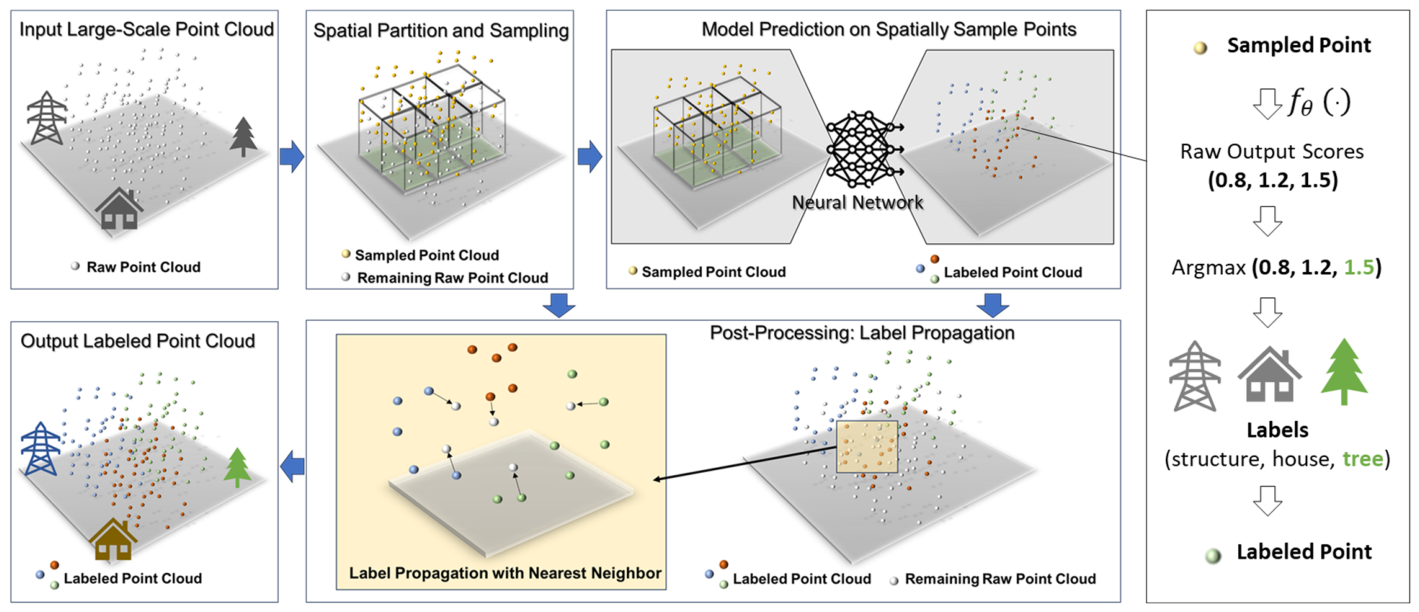
- Spatial surrogate modeling improves point-wise segmentation accuracy by enhancing label propagation, an often overlooked step in large-scale 3D point cloud semantic segmentation. The post-processing strategy can be applied to the outputs of an existing pre-trained model without additional neural network training which is important in a specific practical application when a pre-trained model is provided by a research project but the original training data are unavailable and only limited labeled target-site data can be obtained, making it difficult for reliable fine-tunning.
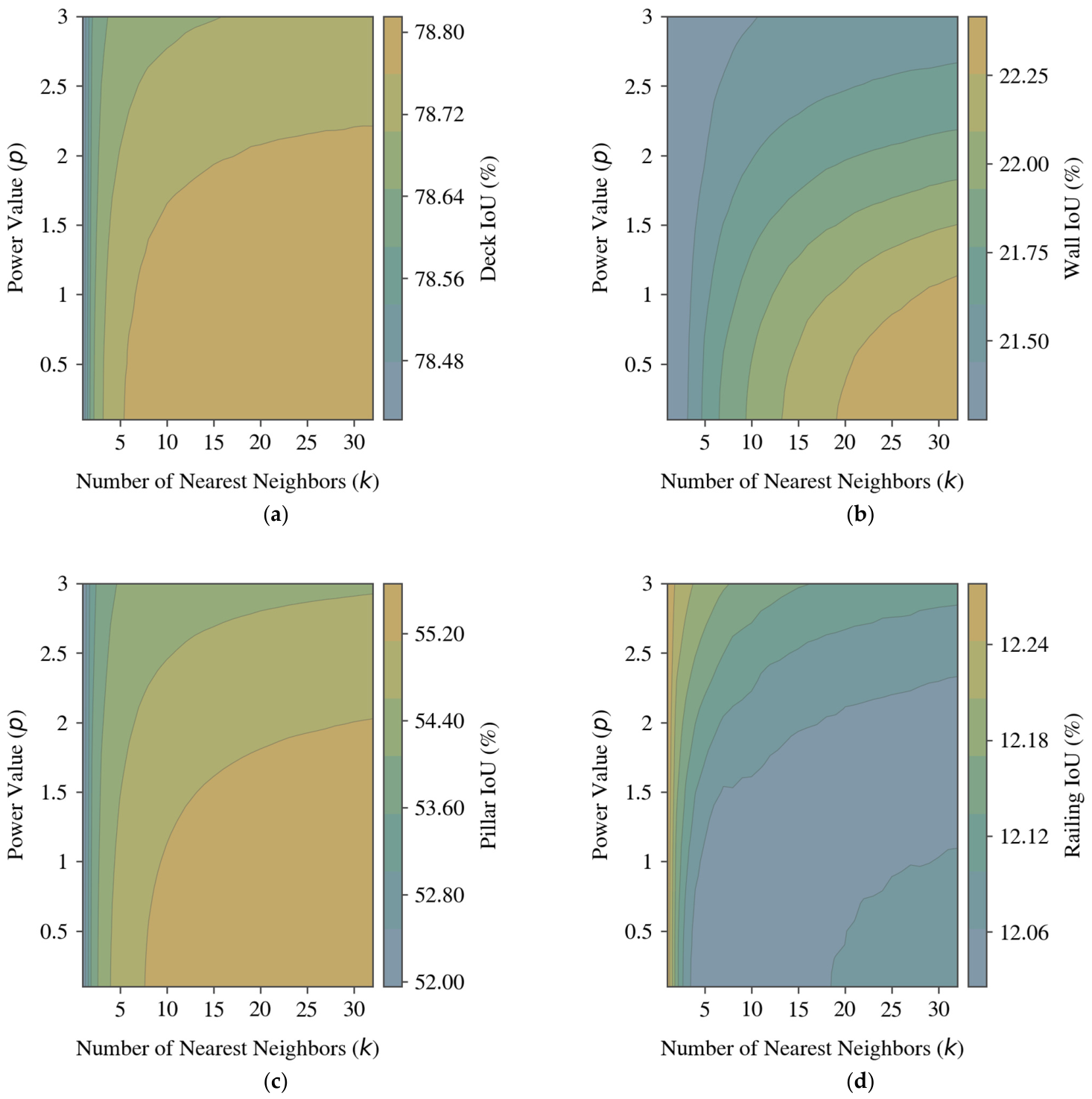
- Different semantic classes benefit from diverse configurations of spatial surrogate modeling, indicating class-specific spatial-scale dependence during label propagation.
- The evaluated response surfaces support site-specific calibration when limited target-site labels are available and provide empirical starting settings for comparable bridge applications when target-site labels are unavailable.
- Label propagation for annotating points not directly predicted by a neural network should be treated as an important spatial modeling step rather than a simple technical completion procedure.
- Spatially informed label propagation can improve the accuracy and reliability of applications that depend on precise spatial measurement and object delineation using hydraulic-structure LiDAR point clouds.
Abstract
1. Introduction
- (1)
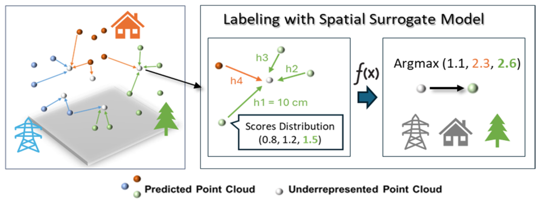
- This study reframes the label propagation for underrepresented points in large-scale hydraulic-structure 3D semantic segmentation as a spatial problem, providing a spatial perspective for improving label propagation in applications where accurate spatial measurement and object delineation are required and where domain-specific pre-trained models may need to be reused without retraining.
- (2)
- We examine spatial surrogate modeling as a spatially aware post-inference label propagation strategy and use IDW as an interpretable proof-of-concept to reveal class-dependent spatial context effects.
- (3)
- Through experiments on field-collected, georeferenced hydraulic-structure and bridge LiDAR point clouds, this study provides empirically informed parameter guidance. The identified favorable and stable parameter ranges can support site-specific calibration when limited labels are available and serve as initial reference settings for comparable bridge applications.
2. Related Work in 3D Semantic Segmentation
2.1. Observed Research Gap in Semantic Segmentation on 3D Point Cloud
2.2. Explicit and Implicit Label Propagation, Refinement, and Upsampling Strategies
2.3. Related Work of Surrogate Model
3. Materials and Methods
3.1. Spatial Surrogate Model for Labeling Underrepresented Points
3.2. Experiment Baseline: A Pracitcal Study Case in Bridge Inspection
3.3. Experiment Design
4. Results
4.1. Baseline Prediction and Underrepresented-Point Coverage
4.2. Scene-Level Analysis of IDW-Based Label Propagation
4.3. Component-Level Evaluation Using the DeepHyd Bridge-Component Model
5. Discussion
5.1. Label Propagation as a Spatial Post-Processing Problem
5.2. Practical Value for Hydraulic-Structure LiDAR Applications
5.3. Limitations and Future Work
6. Conclusions
Author Contributions
Funding
Data Availability Statement
Conflicts of Interest
References
- Janowicz, K.; Gao, S.; McKenzie, G.; Hu, Y.; Bhaduri, B. GeoAI: Spatially explicit artificial intelligence techniques for geographic knowledge discovery and beyond. Int. J. Geogr. Inf. Sci. 2020, 34, 625–636. [Google Scholar]
- Janowicz, K.; Mai, G.; Huang, W.; Zhu, R.; Lao, N.; Cai, L. GeoFM: How will geo-foundation models reshape spatial data science and GeoAI? Int. J. Geogr. Inf. Sci. 2025, 39, 1849–1865. [Google Scholar] [CrossRef]
- VoPham, T.; Hart, J.E.; Laden, F.; Chiang, Y.-Y. Emerging trends in geospatial artificial intelligence (geoAI): Potential applications for environmental epidemiology. Environ. Health 2018, 17, 40. [Google Scholar] [CrossRef] [PubMed]
- Mai, G.; Xie, Y.; Jia, X.; Lao, N.; Rao, J.; Zhu, Q.; Liu, Z.; Chiang, Y.-Y.; Jiao, J. Towards the next generation of Geospatial Artificial Intelligence. Int. J. Appl. Earth Obs. Geoinf. 2025, 136, 104368. [Google Scholar] [CrossRef]
- Ballouch, Z.; Jeddoub, I.; Hajji, R.; Kasprzyk, J.-P.; Billen, R. Towards a Digital Twin of Liege: The Core 3D Model based on Semantic Segmentation and Automated Modeling of LiDAR Point Clouds. ISPRS Ann. Photogramm. Remote Sens. Spat. Inf. Sci. 2024, 10, 13–20. [Google Scholar] [CrossRef]
- Wang, S.; Huang, X.; Liu, P.; Zhang, M.; Biljecki, F.; Hu, T.; Fu, X.; Liu, L.; Liu, X.; Wang, R. Mapping the landscape and roadmap of geospatial artificial intelligence (GeoAI) in quantitative human geography: An extensive systematic review. Int. J. Appl. Earth Obs. Geoinf. 2024, 128, 103734. [Google Scholar] [CrossRef]
- Hu, Y.; Goodchild, M.; Zhu, A.-X.; Yuan, M.; Aydin, O.; Bhaduri, B.; Gao, S.; Li, W.; Lunga, D.; Newsam, S. A five-year milestone: Reflections on advances and limitations in GeoAI research. Ann. GIS 2024, 30, 1–14. [Google Scholar] [CrossRef]
- EO, E.O. Towards responsible geospatial foundation models. Nat. Mach. Intell. 2025, 7, 1189. [Google Scholar] [CrossRef]
- Chen, T.; Tang, W.; Allan, C.; Chen, S.-E. Explicit Incorporation of Spatial Autocorrelation in 3D Deep Learning for Geospatial Object Detection. Ann. Am. Assoc. Geogr. 2024, 114, 2297–2316. [Google Scholar] [CrossRef]
- Chen, T.; Tang, W.; Chen, S.-E.; Allan, C. SA-Encoder: A Learnt Spatial Autocorrelation Representation to Inform 3D Geospatial Object Detection. Remote Sens. 2025, 17, 3124. [Google Scholar] [CrossRef]
- Ye, X.; Yigitcanlar, T.; Goodchild, M.; Huang, X.; Li, W.; Shaw, S.-L.; Fu, Y.; Gong, W.; Newman, G. Artificial intelligence in urban science: Why does it matter? Ann. GIS 2025, 31, 181–189. [Google Scholar] [CrossRef] [PubMed]
- Qi, C.; Su, H.; Mo, K.; Guibas, L.J. Pointnet: Deep learning on point sets for 3d classification and segmentation. In Proceedings of the IEEE Conference on Computer Vision and Pattern Recognition, Honolulu, HI, USA, 20–26 July 2017. [Google Scholar]
- Sun, X.; Guo, B.; Li, C.; Sun, N.; Wang, Y.; Yao, Y. Semantic segmentation and roof reconstruction of urban buildings based on LiDAR point clouds. ISPRS Int. J. Geo-Inf. 2024, 13, 19. [Google Scholar] [CrossRef]
- Boulch, A. ConvPoint: Continuous convolutions for point cloud processing. Comput. Graph. 2020, 88, 24–34. [Google Scholar] [CrossRef]
- Betsas, T.; Georgopoulos, A.; Doulamis, A.; Grussenmeyer, P. Deep learning on 3d semantic segmentation: A detailed review. Remote Sens. 2025, 17, 298. [Google Scholar] [CrossRef]
- Zhou, C.; Shu, Z.; Shi, L.; Ling, Q. Semantic segmentation for large-scale point clouds based on hybrid attention and dynamic fusion. Pattern Recognit. 2024, 156, 110798. [Google Scholar] [CrossRef]
- Zhan, W.; Chen, J. SADNet: Space-aware DeepLab network for Urban-Scale point clouds semantic segmentation. Int. J. Appl. Earth Obs. Geoinf. 2024, 129, 103827. [Google Scholar] [CrossRef]
- Kleijnen, J.P. Statistical Tools for Simulation Practitioners; Marcel Dekker: New York, NY, USA, 1987. [Google Scholar]
- Kleijnen, J.P. Kriging metamodeling in simulation: A review. Eur. J. Oper. Res. 2009, 192, 707–716. [Google Scholar] [CrossRef]
- Forrester, A.; Sobester, A.; Keane, A. Engineering Design via Surrogate Modelling: A Practical Guide; John Wiley & Sons: Hoboken, NJ, USA, 2008. [Google Scholar]
- Lam, N.S.-N. Spatial interpolation methods: A review. Am. Cartogr. 1983, 10, 129–150. [Google Scholar] [CrossRef]
- Oliver, M.A.; Webster, R. Kriging: A method of interpolation for geographical information systems. Int. J. Geogr. Inf. Syst. 1990, 4, 313–332. [Google Scholar] [CrossRef]
- Kattenborn, T.; Schiefer, F.; Frey, J.; Feilhauer, H.; Mahecha, M.D.; Dormann, C.F. Spatially autocorrelated training and validation samples inflate performance assessment of convolutional neural networks. ISPRS Open J. Photogramm. Remote Sens. 2022, 5, 100018. [Google Scholar] [CrossRef]
- Qi, C.; Yi, L.; Su, H.; Guibas, L.J. Pointnet++: Deep hierarchical feature learning on point sets in a metric space. Adv. Neural Inf. Process. Syst. 2017, 30. [Google Scholar] [CrossRef]
- Thomas, H.; Qi, C.R.; Deschaud, J.-E.; Marcotegui, B.; Goulette, F.; Guibas, L.J. Kpconv: Flexible and deformable convolution for point clouds. In Proceedings of the IEEE/CVF International Conference on Computer Vision, Seoul, Republic of Korea, 27 October–2 November 2019. [Google Scholar]
- Hu, Q.; Yang, B.; Xie, L.; Rosa, S.; Guo, Y.; Wang, Z.; Trigoni, N.; Markham, A. Learning semantic segmentation of large-scale point clouds with random sampling. IEEE Trans. Pattern Anal. Mach. Intell. 2021, 44, 8338–8354. [Google Scholar] [CrossRef]
- Zhao, H.; Jiang, L.; Jia, J.; Torr, P.H.; Koltun, V. Point transformer. In Proceedings of the IEEE/CVF International Conference on Computer Vision, Montreal, QC, Canada, 11–17 October 2021. [Google Scholar]
- Kolodiazhnyi, M.; Vorontsova, A.; Konushin, A.; Rukhovich, D. Oneformer3d: One transformer for unified point cloud segmentation. In Proceedings of the IEEE/CVF Conference on Computer Vision and Pattern Recognition, Seattle, WA, USA, 17–21 June 2024. [Google Scholar]
- Chen, S.; Fang, Z.; Wan, S.; Zhou, T.; Chen, C.; Wang, M.; Li, Q. Geometrically aware transformer for point cloud analysis. Sci. Rep. 2025, 15, 16545. [Google Scholar] [CrossRef] [PubMed]
- Zhong, J.; Jiang, H.; Ji, Y.; Li, Y.; Xue, Y. CSP-Former: A Transformer-Based Network for Point Cloud Analysis with Compressed Sensing and Spatial Self-Attention. Electronics 2025, 14, 347. [Google Scholar] [CrossRef]
- Tchapmi, L.; Choy, C.; Armeni, I.; Gwak, J.; Savarese, S. Segcloud: Semantic segmentation of 3d point clouds. In Proceedings of the 2017 International Conference on 3D Vision (3DV), Qingdao, China, 10–12 October 2017. [Google Scholar]
- Landrieu, L.; Simonovsky, M. Large-scale point cloud semantic segmentation with superpoint graphs. In Proceedings of the IEEE Conference on Computer Vision and Pattern Recognition, Salt Lake City, UT, USA, 18–22 June 2018. [Google Scholar]
- Li, M.; Xie, Y.; Shen, Y.; Ke, B.; Qiao, R.; Ren, B.; Lin, S.; Ma, L. Hybridcr: Weakly-supervised 3d point cloud semantic segmentation via hybrid contrastive regularization. In Proceedings of the IEEE/CVF Conference on Computer Vision and Pattern Recognition, New Orleans, LA, USA, 18–24 June 2022. [Google Scholar]
- Yu, L.; Li, X.; Fu, C.-W.; Cohen-Or, D.; Heng, P.-A. Pu-net: Point cloud upsampling network. In Proceedings of the IEEE Conference on Computer Vision and Pattern Recognition, Salt Lake City, UT, USA, 18–22 June 2018. [Google Scholar]
- Wang, G.; Wang, L.; Wu, S.; Zu, S.; Song, B. Semantic Segmentation of Transmission Corridor 3D Point Clouds Based on CA-PointNet++. Electronics 2023, 12, 2829. [Google Scholar] [CrossRef]
- Cheng, G.; Gu, C. Enhancing point cloud classification and segmentation with attention-enhanced SO-PointNet++. IEEE Access 2024, 12, 195986–195995. [Google Scholar] [CrossRef]
- Jing, Z.; Guan, H.; Zhao, P.; Li, D.; Yu, Y.; Zang, Y.; Wang, H.; Li, J. Multispectral LiDAR Point Cloud Classification Using SE-PointNet++. Remote Sens. 2021, 13, 2516. [Google Scholar] [CrossRef]
- Li, Z.; Chen, L.; Liu, Y.; Zhao, S.; Guan, Q. RWAFormer: A lightweight road LiDAR point cloud segmentation network based on transformer. Front. Comput. Sci. 2025, 7, 1542813. [Google Scholar] [CrossRef]
- Tian, S.; Li, M.; Cao, L.; Kang, L.; Tian, J.; Xing, X.; Shen, B.; Du, K.; Fu, C.; Zhang, Y. Hybrid Attention Driven CNN-Mamba Multimodal Fusion Network for Remote Sensing Image Semantic Segmentation. IEEE J. Sel. Top. Appl. Earth Obs. Remote Sens. 2025, 19, 2254–2272. [Google Scholar] [CrossRef]
- Engelund, W.C.; Stanley, D.O.; Lepsch, R.A.; McMillin, M.M.; Unal, R. Aerodynamic configuration design using response surface methodology analysis. NASA STI/Recon Tech. Rep. A 1993, 94, 10718. [Google Scholar]
- Venter, G.; Haftka, R.; Starnes, J.J. Construction of response surfaces for design optimization applications. In Proceedings of the 6th Symposium on Multidisciplinary Analysis and Optimization, Bellevue, WA, USA, 4–6 September 1996. [Google Scholar]
- Smith, M. Neural Networks for Statistical Modeling; Thomson Learning: Boston, MA, USA, 1993. [Google Scholar]
- Tang, M.; Liu, Y.; Durlofsky, L.J. A deep-learning-based surrogate model for data assimilation in dynamic subsurface flow problems. J. Comput. Phys. 2020, 413, 109456. [Google Scholar] [CrossRef]
- Friedman, J.H. Multivariate adaptive regression splines. Ann. Stat. 1991, 19, 1–67. [Google Scholar] [CrossRef]
- Hardy, R.L. Multiquadric equations of topography and other irregular surfaces. J. Geophys. Res. 1971, 76, 1905–1915. [Google Scholar] [CrossRef]
- Buhmann, M.D. Radial basis functions. Acta Numer. 2000, 9, 1–38. [Google Scholar] [CrossRef]
- Kleijnen, J.P.; Sargent, R.G. A methodology for fitting and validating metamodels in simulation. Eur. J. Oper. Res. 2000, 120, 14–29. [Google Scholar] [CrossRef]
- Shepard, D. A two-dimensional interpolation function for irregularly-spaced data. In Proceedings of the 1968 23rd ACM National Conference, Las Vegas, NV, USA, 27–29 August 1968. [Google Scholar]
- Shanmugam, N.S.; Chen, S.-E.; Tang, W.; Chavan, V.S.; Diemer, J.; Allan, C.; Shukla, T.; Chen, T.; Slocum, Z.; Janardhanam, R. Spatial Interpolation of Bridge Scour Point Cloud Data Using Ordinary Kriging Method. J. Perform. Constr. Facil. 2025, 39, 06024002. [Google Scholar] [CrossRef]
- Chen, T.; Xie, Y.; Liu, C.; Bai, Y.; Zhang, A.; Mao, L.; Fan, S. Trend analysis of relationship between primary productivity, precipitation and temperature in Inner Mongolia. ISPRS Int. J. Geo-Inf. 2018, 7, 214. [Google Scholar] [CrossRef]
- Guo, C.; Pleiss, G.; Sun, Y.; Weinberger, K.Q. On calibration of modern neural networks. In Proceedings of the International Conference on Machine Learning, Sydney, Australia, 6–11 August 2017. [Google Scholar]
- Müller, R.; Kornblith, S.; Hinton, G.E. When does label smoothing help? Adv. Neural Inf. Process. Syst. 2019, 32. [Google Scholar] [CrossRef]
- Jing, Y.; Sheil, B.; Acikgoz, S. A lightweight Transformer-based neural network for large-scale masonry arch bridge point cloud segmentation. Comput.-Aided Civ. Infrastruct. Eng. 2024, 39, 2427–2438. [Google Scholar] [CrossRef]
- Yang, L.; Hu, P.; Yuan, S.; Zhang, L.; Liu, J.; Shen, H.; Zhu, X. Towards Explicit Geometry-Reflectance Collaboration for Generalized LiDAR Segmentation in Adverse Weather. In Proceedings of the Computer Vision and Pattern Recognition Conference, Nashville, TN, USA, 11–15 June 2025. [Google Scholar]
- Cui, N.; Chen, H.; Guo, X.; Zeng, Y.; Hua, Z.; Xiong, G.; Yue, R.; Liu, J. Self-prompting semantic segmentation of bridge point cloud data using a large computer vision model. Autom. Constr. 2024, 167, 105729. [Google Scholar] [CrossRef]
- Zeng, Y.; Huang, F.; Xiong, G.; Ma, X.; Peng, Y.; Yang, W.; Liu, J. Bridge point cloud semantic segmentation based on view consensus and cross-view self-prompt fusion. Autom. Constr. 2025, 171, 106003. [Google Scholar] [CrossRef]
- Xu, J.; Shi, M.; Cabral, R.; Ribeiro, D.; Yu, W.; Wu, H.; Narazaki, Y. Domain-generalizable point cloud instance segmentation of bridge components using class-balanced dynamic thresholding. Autom. Constr. 2026, 181, 106631. [Google Scholar] [CrossRef]
- Tang, W.; Chen, S.-E.; Diemer, J.; Allan, C.; Chen, T.; Slocum, Z.; Shukla, T.; Chavan, V.S.; Shanmugam, N.S. DeepHyd: A Deep Learning-Based Artificial Intelligence Approach for the Automated Classification of Hydraulic Structures from LiDAR and Sonar Data; North Carolina Department of Transportation. Research and Development Unit: Raleigh, NC, USA, 2022. [Google Scholar]
- Shelton, T.; Poorthuis, A. The nature of neighborhoods: Using big data to rethink the geographies of Atlanta’s neighborhood planning unit system. Ann. Am. Assoc. Geogr. 2019, 109, 1341–1361. [Google Scholar] [CrossRef]
- Rezatofighi, H.; Tsoi, N.; Gwak, J.; Sadeghian, A.; Reid, I.; Savarese, S. Generalized intersection over union: A metric and a loss for bounding box regression. In Proceedings of the IEEE/CVF Conference on Computer Vision and Pattern Recognition, Long Beach, CA, USA, 15–20 June 2019. [Google Scholar]
- Song, J.; Zhou, X.; Xu, C.; Xu, S.; Shu, J. Training-free automatic instance segmentation of girder bridge point cloud via large model fusion with reverse entity modelling verification. Autom. Constr. 2025, 179, 106484. [Google Scholar] [CrossRef]



| Parameter | Values |
|---|---|
| k (number of neighbors) | 1–32 (step = 1) |
| p (power of distance decay) | 0.1–3.0 (step = 0.1) |
| Scan Name | Number of Total Points | Number of Predicted | Predicted Rate |
|---|---|---|---|
| Scan 1 | 719,106 | 350,558 | 48.75% |
| Scan 2 | 1,085,824 | 242,730 | 22.35% |
| Scan 3 | 8,009,476 | 2,539,892 | 31.71% |
| Scan 4 | 3,382,589 | 1,381,216 | 40.83% |
| Scan 5 | 4,239,833 | 1,289,660 | 30.42% |
| Scan 6 | 1,313,687 | 782,698 | 59.58% |
| Scan 7 | 11,061,405 | 2,790,427 | 25.23% |
| Scan 8 | 6,253,579 | 1,044,304 | 16.70% |
| Scan 9 | 4,435,961 | 1,214,976 | 27.39% |
| Scan 10 | 5,705,619 | 921,896 | 16.16% |
| Average | 4,620,708 | 1,255,836 | 31.91% |
| Measurement | Values |
|---|---|
| OA | 86.71% |
| mIoU | 73.08% |
| Bridge IoU | 94.11% |
| Vegetation IoU | 51.49% |
| Ground IoU | 73.65% |
Disclaimer/Publisher’s Note: The statements, opinions and data contained in all publications are solely those of the individual author(s) and contributor(s) and not of MDPI and/or the editor(s). MDPI and/or the editor(s) disclaim responsibility for any injury to people or property resulting from any ideas, methods, instructions or products referred to in the content. |
© 2026 by the authors. Licensee MDPI, Basel, Switzerland. This article is an open access article distributed under the terms and conditions of the Creative Commons Attribution (CC BY) license.
Share and Cite
Chen, T.; Tang, W.; Chen, S.-E.; Allan, C.; Shanmugam, N.S. Revisiting Deep Learning-Based Semantic Segmentation on Large-Scale Hydraulic-Structure LiDAR Point Clouds: A Spatial Surrogate Modeling Perspective. Remote Sens. 2026, 18, 2413. https://doi.org/10.3390/rs18142413
Chen T, Tang W, Chen S-E, Allan C, Shanmugam NS. Revisiting Deep Learning-Based Semantic Segmentation on Large-Scale Hydraulic-Structure LiDAR Point Clouds: A Spatial Surrogate Modeling Perspective. Remote Sensing. 2026; 18(14):2413. https://doi.org/10.3390/rs18142413
Chicago/Turabian StyleChen, Tianyang, Wenwu Tang, Shen-En Chen, Craig Allan, and Navanit Sri Shanmugam. 2026. "Revisiting Deep Learning-Based Semantic Segmentation on Large-Scale Hydraulic-Structure LiDAR Point Clouds: A Spatial Surrogate Modeling Perspective" Remote Sensing 18, no. 14: 2413. https://doi.org/10.3390/rs18142413
APA StyleChen, T., Tang, W., Chen, S.-E., Allan, C., & Shanmugam, N. S. (2026). Revisiting Deep Learning-Based Semantic Segmentation on Large-Scale Hydraulic-Structure LiDAR Point Clouds: A Spatial Surrogate Modeling Perspective. Remote Sensing, 18(14), 2413. https://doi.org/10.3390/rs18142413