Article

Temporary Floodplain Ponds Shape Vegetation Mosaic in a Natural River Valley: Evidence from SAR and Optical Remote Sensing


1
Department of Environmental Development and Remote Sensing, Institute of Environmental Engineering, Warsaw University of Life Sciences, 02-787 Warsaw, Poland
2
Department of Hydrology, Meteorology and Water Management, Institute of Environmental Engineering, Warsaw University of Life Sciences, 02-787 Warsaw, Poland
3
Department of Geodesy, Institute of Geodesy and Civil Engineering, University of Warmia and Mazury, 10-719 Olsztyn, Poland
4
Centre for Climate Research, Warsaw University of Life Sciences, 02-787 Warsaw, Poland
*
Author to whom correspondence should be addressed.
Remote Sens. 2026, 18(14), 2292; https://doi.org/10.3390/rs18142292
Submission received: 29 May 2026 / Revised: 2 July 2026 / Accepted: 7 July 2026 / Published: 9 July 2026
(This article belongs to the Section Ecological Remote Sensing)

Highlights

What are the main findings?
  • Temporary floodplain ponds (TFPs) occupied more than 32% of the floodplain surface shortly after spring flood recession and stored over 250 L m−2 of surface water.
  • Integrating TerraSAR-X SAR data with Sentinel-2 multispectral imagery improved vegetation classification accuracy from 64.5% to 81.7% and enabled detection of fine-scale vegetation mosaics associated with TFPs.
What are the implications of the main findings?
  • TFP depth was the strongest predictor of plant community distribution, acting as a fine-scale hydrological filter within the floodplain.
  • Changes in TFP persistence may shift the balance between moisture-dependent communities and communities associated with better-drained conditions.

Abstract

Temporary floodplain ponds (TFPs) are short-lived water bodies forming in microtopographic depressions after flood recession and represent an important but poorly quantified component of floodplain hydrology. This study investigated the spatial and temporal dynamics of TFPs and their relationship with vegetation patterns in the natural floodplain of the Biebrza River, Poland. High-resolution TerraSAR-X data and Sentinel-2 multispectral imagery were combined with field-based vegetation surveys and statistical modeling. Threshold-based SAR classification showed that TFPs occupied more than 32% of the floodplain surface shortly after spring flood recession and stored, on average, over 250 L m−2 of surface water, but disappeared within one month. Random Forest classification demonstrated that combining SAR and multispectral data improved overall vegetation mapping accuracy from 64.5% to 81.7% (Kappa from 0.574 to 0.780). A global chi-square test revealed a strong association between vegetation patterns and TFP occurrence (χ2 = 224.9, p < 0.001, Cramér’s V = 0.40). Multinomial logistic regression identified TFP depth as the strongest predictor of plant community distribution. Rorippo-Agrostietum, Caricetum gracilis and Glycerietum maximae increased with TFP depth, whereas Alopecuretum pratensis and Phalaridetum arundinaceae declined. These results show that TFPs act as a fine-scale hydrological filter structuring floodplain vegetation mosaics and that SAR–optical data fusion is effective for detecting these transient habitat patterns.

1. Introduction

Surface water retention plays a fundamental role in regulating ecosystem functioning in river valleys by controlling soil moisture dynamics, nutrient cycling and the spatial distribution of biological communities. Floodplain ecosystems are characterized by pronounced habitat heterogeneity, largely driven by periodic inundation and subsequent drainage, which together shape vegetation patterns and sustain high levels of biodiversity. Although flooding has long been recognized as a key driver of floodplain processes [1,2], the ecological consequences of the fine-scale spatial mosaic of residual surface water persisting after flood recession remain insufficiently explored.
The spatial mosaic of floodplain habitats is not created solely by large flood events but also by numerous small-scale inundation pulses associated with flood dynamics. These processes generate a highly heterogeneous hydrological landscape in which areas of temporary water retention coexist with rapidly draining surfaces [3,4]. Such variability in inundation patterns contributes to the structural complexity of floodplains and underpins the coexistence of diverse biological communities.
In this study, we focus on temporary floodplain ponds (TFPs)—small, temporary water bodies that persist in microtopographic depressions following spring floods. These features remain hydrologically connected to the river channel only temporarily and persist until water drains, evaporates, or infiltrates into the soil. In operational terms, TFPs were defined here as spatially coherent, stagnant water bodies formed in local topographic depressions following the spring flood, separated from the main river channel after floodwater recession, and absent from the pre-flood SAR image. Permanent water bodies, channels, oxbow lakes, and small spatially scattered water detections were excluded from this category. TFPs represent a common but transient component of floodplain hydrology and are comparable to other temporary wetland systems described in the literature, including temporary ponds [5], post-flood ephemeral wetlands [6], and vernal pools [7]. Despite differences in geomorphological context, these systems share several ecological characteristics, including periodic hydroperiods, high environmental variability, absence of permanent aquatic fauna, and strong importance for biodiversity and landscape water retention.
The ecological significance of such temporary aquatic habitats has been widely documented across taxonomic groups. Spatial and temporal variability in flooding patterns strongly influences insect abundance [8], aquatic macroinvertebrate communities [9,10], amphibian breeding habitats [6], fish recruitment in intermittent rivers [11,12], and even vertebrate activity patterns in terrestrial landscapes [7]. These findings highlight the role of temporary floodplain water bodies as biodiversity hotspots and ecological refugia during transitional hydrological phases.
TFPs act as fine-scale hydrological filters that influence plant community assembly by extending soil saturation beyond the flood peak. River valleys are continually reshaped by periodic shallow inundation, generating spatial gradients in moisture availability that drive transformations in vegetation structure. While most floodplain plant species exhibit some degree of flood tolerance, their adaptive strategies differ markedly, resulting in distinct community responses to prolonged surface water retention. Consequently, the persistence of TFPs is expected to favor moisture-dependent assemblages while limiting communities adapted to rapidly draining conditions [3,13].
The formation and persistence of TFPs are governed by microrelief, soil properties, vegetation structure and hydraulic connectivity between the river channel and the floodplain. Organic soils typical of lowland valleys slow infiltration, promoting the retention of shallow surface water, while dense sedge- and grass-dominated vegetation reduces flow velocity and enhances local water accumulation. Together, these factors create fine-scale moisture gradients that produce a mosaic of habitats fundamental to the functioning of floodplain ecosystems and to species dependent on spring water availability [3,13].
The ecological role of TFPs is becoming increasingly important under ongoing climate change and hydrological alteration. Reduced snow cover, earlier flood recession and more frequent droughts shorten the duration of post-flood surface water retention, causing soils to dry more rapidly and limiting the period of saturated conditions critical for many floodplain processes. Changes in inundation regimes may also arise from river regulation and water management structures, which can modify flood timing, duration and spatial extent of wetland vegetation [13]. Such hydrological shifts may ultimately alter vegetation composition and habitat structure across floodplain landscapes.
Despite their ecological importance, TFPs remain challenging to quantify due to their short hydroperiod and high spatial heterogeneity. Conventional field-based approaches provide limited spatial coverage, while many remote sensing studies of floodplains focus on peak inundation rather than post-flood surface water dynamics. As a result, the spatial linkage between temporary post-flood ponds and vegetation community patterns remains insufficiently resolved at ecologically meaningful scales, representing a persistent knowledge gap in floodplain ecology [14,15,16].
Recent advances in remote sensing provide new opportunities to address this challenge. Temporary wetland habitats can be detected using multispectral satellite imagery, synthetic aperture radar (SAR) data, LiDAR-derived elevation models, and topographic indices [14]. Multi-temporal remote sensing approaches are particularly important for capturing dynamic wetland systems with short hydroperiods [16]. Recent developments combining satellite time series with machine learning and deep learning models further improve the detection of land–water transitions and wetland vegetation dynamics [15].
Synthetic Aperture Radar (SAR) is particularly well suited for monitoring floodplain hydrology [17] because it can detect shallow surface water beneath sparse or flattened vegetation and operates independently of cloud cover and solar illumination [14,18]. However, radar backscatter alone has limited capability to discriminate vegetation communities with similar structural properties [19]. Optical imagery in the visible and near-infrared range complements SAR by capturing phenological and biochemical differences among plant communities. The integration of SAR and optical data therefore provides a synergistic approach that links hydrological sensitivity to surface water with multispectral discrimination of vegetation.
The aim of this study was to investigate the spatial and temporal dynamics of temporary floodplain ponds (TFPs) and their relationship with vegetation patterns in a natural river valley. Specifically, we addressed three research questions:
  • How extensive are temporary floodplain ponds within the valley and how does their spatial extent change during the post-flood period?
  • Can remote sensing data be used to identify the vegetation mosaic associated with temporary floodplain ponds?
  • How does the depth of temporary floodplain ponds influence the distribution of plant communities?
Because the aim of the study was to relate plant community distribution to fine-scale post-flood hydrological conditions rather than to reconstruct seasonal vegetation dynamics, field-based vegetation surveys were used as the primary source of community identification, while SAR-derived information on post-flood surface water and optical satellite imagery provided the spatial framework for quantifying early-season hydrological heterogeneity and evaluating its ecological implications for vegetation patterns in a natural floodplain ecosystem.

2. Materials and Methods

2.1. Study Area

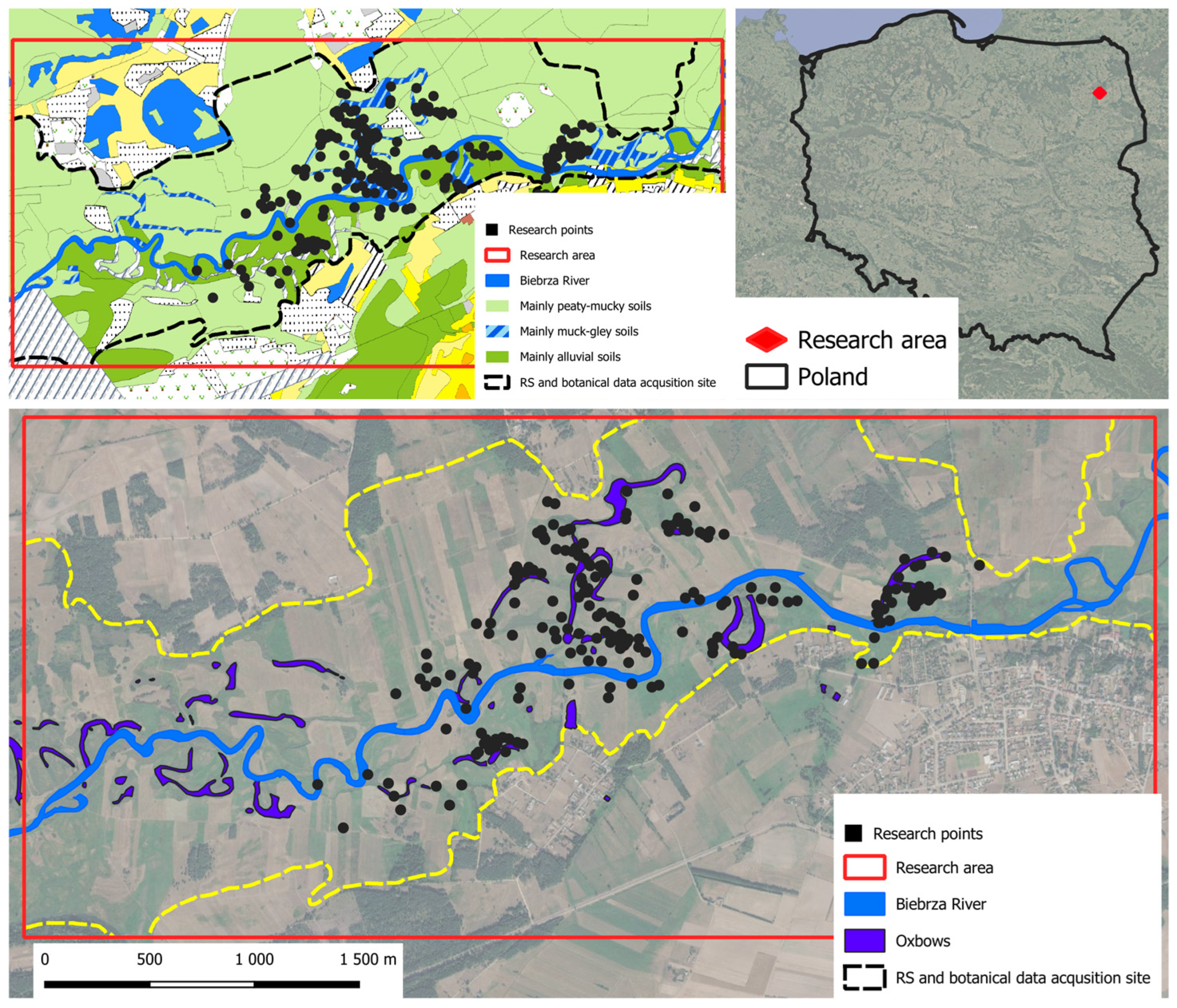
The Biebrza River is in the northeastern part of Poland (Figure 1) and is one of the few large rivers in Europe that has not been transformed by human activity. Its riverbed remains unregulated, causing the river to form extensive floodplains in early spring. These floodplains create a unique mosaic of ecosystems that serve as habitats for many endangered plant and animal species.
The study was conducted in the central basin of the Biebrza River, along an approximately 5 km stretch between the town of Goniądz and the Osowiec Fortress. The central basin of the Biebrza is a vast area of peatlands surrounded by sandy dunes shaped by aeolian processes. It is characterized by the lowest water retention due to an extensive system of drainage canals. As a result, a gradient of plant habitats can be observed, ranging from wet meadows (Alopecurion pratensis All.), through marshy sedge communities (Magnocaricion elatae All.), to reed vegetation (Phalaridetum arundinaceae Ass.). The studied section of the Biebrza River valley is heterogeneous in terms of soils and hydrological conditions. Among the hydrogenic soils occurring are peat, peaty-mucky, peaty-gley, muck and muck-gley soils. These soils develop under prolonged or periodic high groundwater levels or regular flooding and shape hydrological processes of water retention and infiltration, influencing distribution pattern of the floodplain vegetation [20]. Groundwater levels in the study area show high temporal variability, with frequent periods of water occurring at or above the ground surface. Long-term monitoring indicated a decreasing trend in groundwater levels, reflected by progressively fewer and shorter episodes of groundwater rising above the surface [21].

2.2. Vegetation Surveys

Within the study area, 230 research points were initially randomly generated inside the data acquisition boundary to represent the range of vegetation types occurring in the valley. Sampling locations were distributed across the entire floodplain to capture variability in inundation conditions. Phytosociological surveys were conducted in two field campaigns, in May and July 2015. This sampling design was adopted to match the phenology of the studied plant communities and to ensure ecological correspondence with the remotely sensed data. Communities associated with shallow post-flood inundation, especially Rorippo-Agrostietum, were most reliably identified in May, shortly after flood recession, whereas meadow communities were more clearly distinguishable in July, when their floristic composition was fully developed. The vegetation surveys were carried out in homogeneous patches using the Braun-Blanquet method [22] within plots of 2 × 2 m. For each plot, a complete list of vascular plant species was recorded. Each plot was subsequently assigned to one of 24 syntaxonomic units according to the classification of Matuszkiewicz [23]. To focus the analysis on the dominant vegetation patterns of the floodplain, rare vegetation types representing less than 10% of the total area were excluded from further analyses. As a result, 200 research points belonging to six dominant plant community types (Table 1) were retained, representing more than 90% of all recorded vegetation patches in the study area (Figure 1). Each research point was georeferenced using GPS with an accuracy of ±0.1 m, and all data were recorded in a GIS environment to enable spatial integration with radar and multispectral imagery.

2.3. Radar and Multispectral Data

Radar data were obtained from TerraSAR-X platform operating in Staring Spotlight mode in a descending orbit, providing high spatial resolution (0.54 m) essential for detecting small-scale inundation features. Single-polarization HH and VV data were acquired alternately: HH to improve separability between open water, flooded vegetation, and dry surfaces, and VV, due to its higher sensitivity to surface roughness, to improve discrimination among vegetation types. In total, 9 radar scenes were acquired during the first half of 2015 (from March to July), covering the pre-flood, flood, flood-recession, and early summer phases. Flood extent and temporary floodplain pond (TFP) dynamics were delineated using SAR scenes from March, April, and May 2015, which captured the onset, peak, and recession of the spring flood. The analyses focused on the flood recession period because this is the hydrological phase when floodwaters retreat from the floodplain and shallow water remains in local depressions, forming temporary floodplain ponds. All SAR images were acquired as multi-look detected Enhanced Ellipsoid Correction (EEC) products to ensure geometric terrain correction suitable for further integration with optical data. Multispectral imagery from Sentinel-2A (B2, B3, B4, B8) was acquired in July to capture vegetation during its maximum seasonal development and was resampled to match the radar spatial resolution.
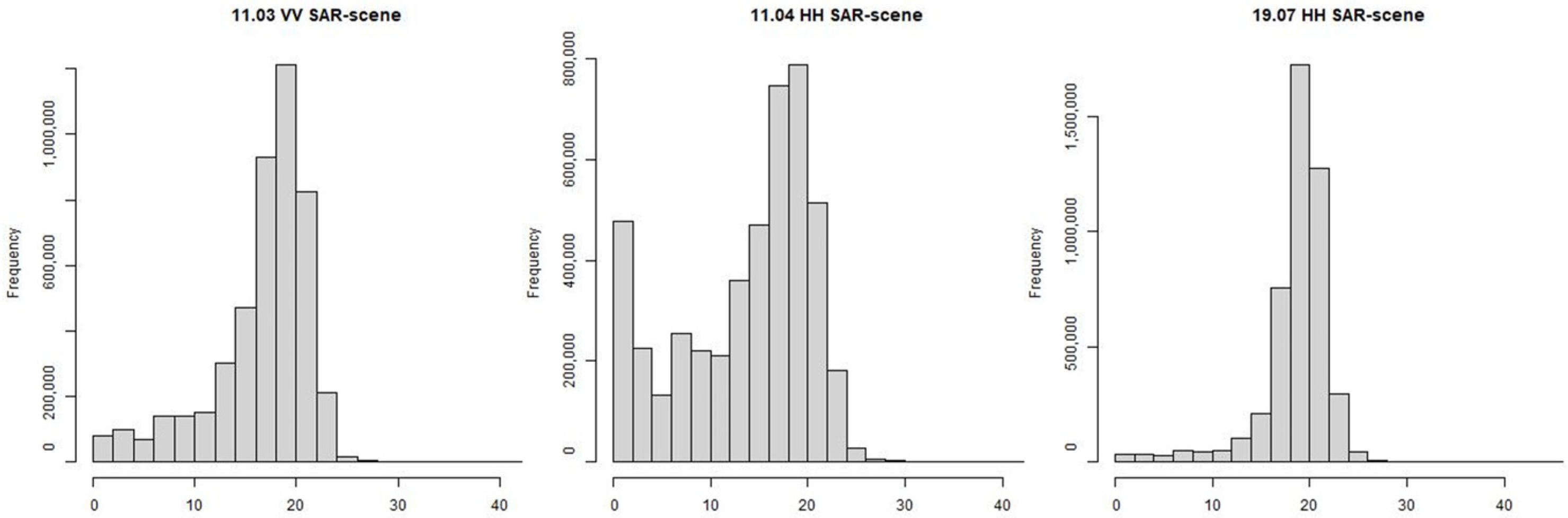
Radar data were first used to identify areas of local ponding formed after the flood. For this purpose, HH-polarized SAR scenes were used to enhance contrast between water and non-water surfaces. A histogram-based thresholding approach was applied to delineate shallow surface water retention areas (Figure 2), as thresholding of SAR backscatter is a widely used and efficient approach for flood-water mapping because water typically exhibits lower backscatter intensity than surrounding land surfaces [24]. In our study, backscatter values were transformed to the decibel scale using 10·log10 (σ0), and pixels with values below a threshold of 10 dB were classified as water. The threshold was selected based on the separation of low-backscatter water pixels from surrounding land surfaces in the SAR backscatter histograms and subsequently verified using field observations and visual interpretation of the scenes.
The volume of water retained in local ponding areas was estimated using SAR-derived water extent combined with a LiDAR-based digital elevation model (DEM). LiDAR data were obtained from publicly available database, GUGiK [25], and characterized by a point density of approximately 4 points in 1 m2, which resulted in a spatial resolution of 0.5 m for the derived DEM. The elevation model was generated from the classified point cloud using the k-nearest neighbors (k-NN) interpolation method. Because LiDAR does not reliably measure water depth directly, the DEM was used to reconstruct the ground surface underlying the inundated areas rather than the water surface itself. For each mapped inundation patch, water depth was estimated relative to the local terrain represented by the DEM, and water volume was then calculated by multiplying the estimated mean water depth by the mapped surface-water extent.
Multitemporal SAR and multispectral imagery were used in plant community classification. We created 4 m buffers around each vegetation research point and generated sample points for all raster pixels falling within each buffer. This buffer size was selected to ensure that the extracted pixels represented a locally homogeneous vegetation patch around each field observation, while also providing a sufficient number of raster cells for stable classifier training and reducing the effect of small positional mismatch between field observations and remote sensing data. Next, we generated sample points for each pixel within the buffer area. These sample points were then used to train a pixel-based classifier for plant community classification. To predict plant community classes, we fitted Random Forest models. The dataset was split into training (70%) and testing (30%) subsets. A 5-fold cross-validation strategy was applied to the training data to assess classifier accuracy and to optimize the number of randomly selected predictors (the model’s tuning parameter). The testing dataset was used to compute the confusion matrix and the Kappa index. The plant community classification was performed on raster data resampled to the spatial resolution of the TerraSAR-X imagery. Accordingly, both the multispectral inputs and the derived classification products represent vegetation patterns at the scale of the radar-based analysis rather than at the scale of individual microhabitats.
Classification performance was evaluated using sensitivity, specificity, and overall accuracy. Sensitivity was defined as the proportion of correctly identified pixels belonging to a given plant community (true positives), specificity as the proportion of correctly identified pixels not belonging to that community (true negatives), and accuracy as the proportion of all correctly classified pixels. We examined the impact of data type on classification accuracy by applying the same modeling strategy using only SAR data and a fusion of SAR and multispectral imagery. Raster processing and machine learning model training were performed in R (version 4.5.2.) using terra [26] and caret [27] packages.

2.4. Statistical Analysis

To examine the relationship between TFPs and the occurrence of the studied plant communities, we first conducted an exploratory chi-square analysis. Within the study area, 1451 random points were generated, to which plant community types derived from Random Forest classification and the presence of TFPs identified from SAR thresholding were assigned. A global chi-square test was used to assess overall association between vegetation types and pond presence, followed by community-specific chi-square tests (2 × 2 contingency tables) to evaluate individual community responses. Effect sizes were quantified using Cramér’s V.
To quantify the relative importance of hydrological and topographic drivers and to account for their combined effects, we subsequently applied multinomial logistic regression. Plant community type was used as the categorical response variable, with Alopecuretum pratensis selected as the reference class. Predictor variables included post-flood water depth, elevation derived from the digital elevation model, local slope, distance to the main river channel, and distance to oxbow lakes. For locations without surface water, post-flood water depth was set to zero, allowing depth to represent both water presence and magnitude of surface retention.
Model significance was evaluated using likelihood ratio tests by comparing the full model with reduced models excluding individual predictors. Odds ratios (OR) and 95% confidence intervals (CI) were calculated to quantify community-specific responses relative to the reference class. Model predictions were further explored by generating probability curves along gradients of individual predictors while holding remaining variables constant at their median values, enabling visualization of hydrological niche differentiation among plant communities.
All statistical analyses were performed in R (version 4.5.2.) using the nnet [28], stats, and rcompanion [29] packages.

3. Results

3.1. Detection and Persistence of TFPs

A pronounced spatial and temporal variability of TFPs was observed within the river valley during the post-flood period.
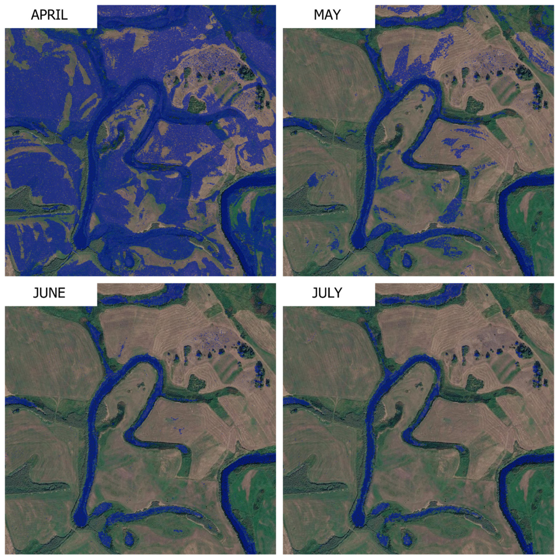
Threshold-based classification of SAR imagery revealed extensive TFPs across the floodplain following the spring flood. One week after peak water levels, TFPs occupied more than 32% of the floodplain surface (Figure 3). In May, their extent decreased to 2.5%, while by July, TFPs were no longer detected within the study area. The volume of retained surface water followed a similar temporal pattern. In April, the average water volume exceeded 250 L m−2, corresponding to approximately 2.5 million liters per hectare. In May, the volume decreased to 20 L m−2, and by July, surface water associated with TFPs had disappeared entirely.

3.2. Classification of Wetland Plant Communities

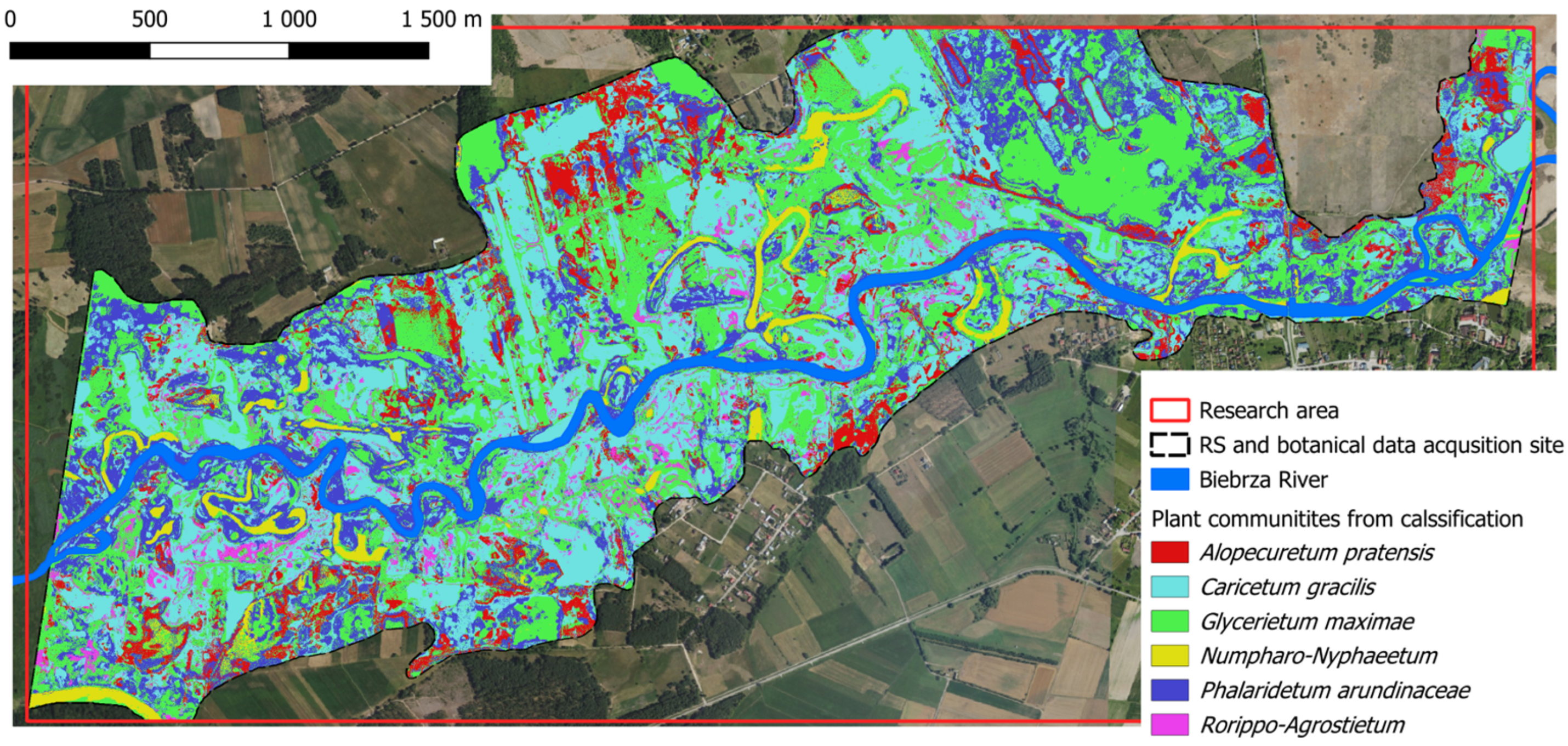
Mapping the spatial heterogeneity of vegetation associated with TFPs requires high-resolution spatial data capable of capturing short-lived habitat mosaics across the floodplain. Traditional field surveys provide detailed local information but are insufficient for identifying the spatial structure of vegetation patterns across the entire valley. Remote sensing therefore provides a necessary framework for detecting the vegetation mosaic associated with TFPs at the landscape scale (Figure 4).
Random Forest classification accuracy depends on input data type. Using multitemporal SAR imagery alone resulted in an overall accuracy of 64.5%. Incorporating Sentinel-2 multispectral data increased classification performance substantially, raising overall accuracy to 81.7%. The Kappa coefficient, which measures classification agreement beyond chance, increased from 0.574 (SAR-only) to 0.780 (SAR + multispectral), indicating an improvement in model reliability.
Classification accuracy differed among plant communities (Table 2). The addition of multispectral imagery improved sensitivity, specificity, and overall accuracy for most vegetation types. The highest classification accuracies were obtained for the aquatic Nupharo-Nymphaeetum and the reed-dominated Phalaridetum arundinaceae communities, both exceeding 94% accuracy when SAR and multispectral data were combined. These communities form relatively homogeneous spatial patches within the floodplain, which likely facilitated their reliable identification in the classification process.
In contrast, the lowest classification accuracy was observed for Rorippo-Agrostietum, followed by Caricetum gracilis and Glycerietum maximae. These vegetation types are typically associated with shallow and dynamically changing inundation zones, where vegetation occurs in small and spatially heterogeneous patches.
Sensitivity increased markedly for Alopecuretum pratensis and Rorippo-Agrostietum following multispectral data integration, nearly doubling in both cases. Although Rorippo-Agrostietum remained the most difficult class to discriminate, its accuracy improved from 66% to 80% with combined datasets.

3.3. Exploratory Association Between Vegetation and TFPs

A global chi-square test revealed a highly significant association between plant community distribution and the presence of TFPs (χ2 = 224.9, df = 4, p < 0.001), with a moderate-to-strong effect size (Cramér’s V = 0.40), indicating non-random spatial coupling between vegetation types and residual surface water.
Community-specific chi-square tests showed contrasting responses among vegetation types (Table 3). Glycerietum maximae and Phalaridetum arundinaceae exhibited strong associations with pond presence (χ2 = 95.7 and 116.8, respectively; p < 0.001), while Alopecuretum pratensis also showed a significant relationship (χ2 = 52.8, p < 0.001). Rorippo-Agrostietum displayed a weaker but still significant association (χ2 = 14.5, p < 0.001), whereas Caricetum gracilis showed no significant relationship with pond occurrence (p = 0.23). Effect sizes ranged from small to moderate (Cramér’s V = 0.11–0.29), suggesting varying degrees of hydrological affinity among communities. The Nupharo-Nymphaeetum community was not tested because it is an aquatic community that inhabits oxbow lakes.

3.4. Hydrological Controls on Vegetation Distribution

Multinomial logistic regression (Table 4) identified TFP depth as the strongest global predictor of plant community distribution (χ2 = 143.5, p < 0.001), followed by elevation (χ2 = 50.7, p < 0.001) and slope (χ2 = 28.7, p < 0.001). Distance to the river channel had a weaker but significant effect (χ2 = 10.5, p = 0.033), whereas distance to oxbow lakes was marginal (χ2 = 9.4, p = 0.052).
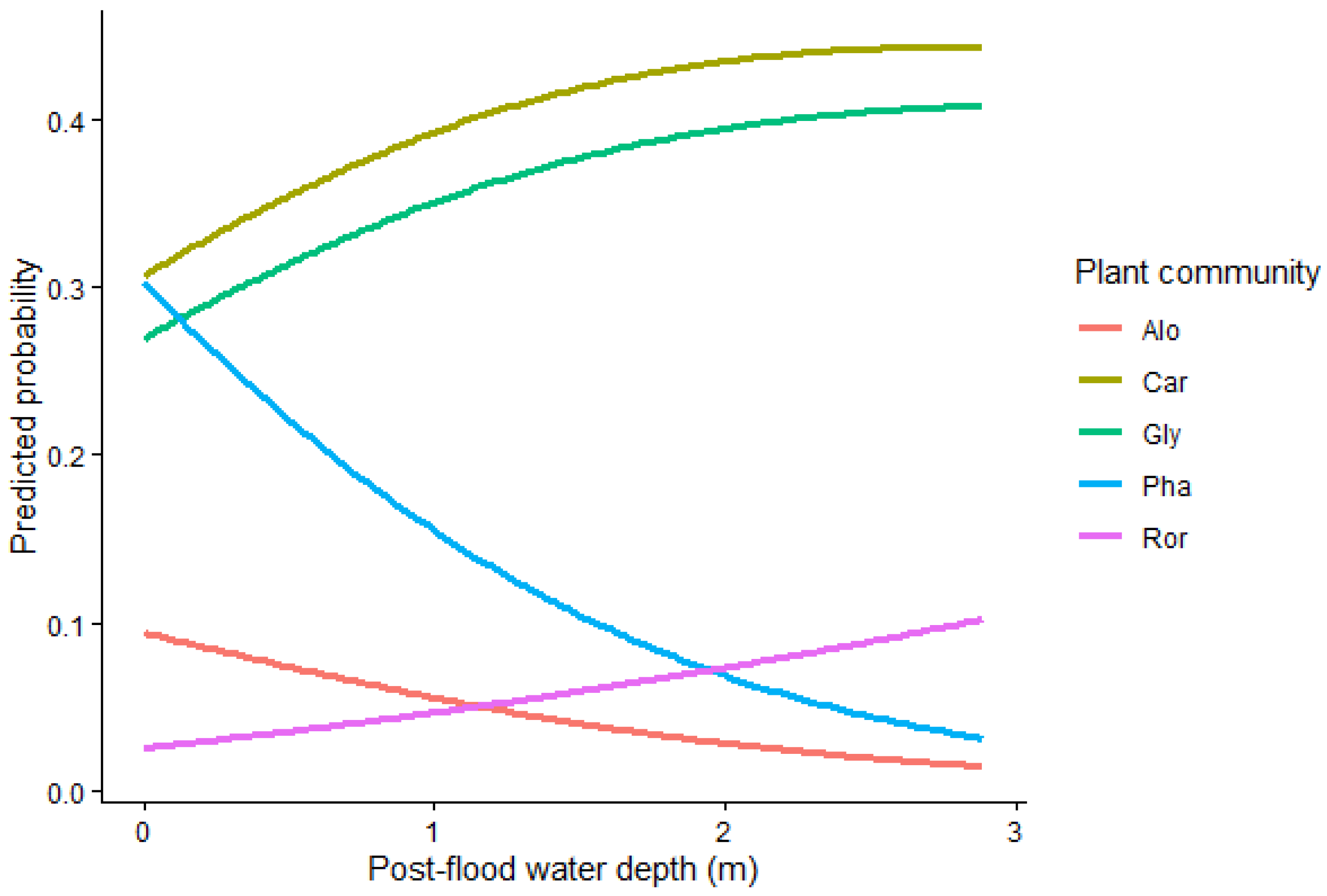
Increasing TFP depth significantly increased the probability of occurrence of Rorippo-Agrostietum (OR = 3.10, 95% CI: 2.15–4.47), Glycerietum maximae (OR = 2.21, 95% CI: 1.67–2.93), and Caricetum gracilis (OR = 2.18, 95% CI: 1.65–2.88) relative to Alopecuretum pratensis. In contrast, Phalaridetum arundinaceae showed no significant response to water depth (OR = 0.87, 95% CI: 0.64–1.18) (Table 5).
Predicted probability curves showed that Rorippo-Agrostietum increased continuously with increasing TFP depth and was nearly absent under dry conditions (Figure 5). The probability of occurrence of Glycerietum maximae and Caricetum gracilis also increased with increasing water depth, whereas Alopecuretum pratensis and Phalaridetum arundinaceae decreased along the same gradient.
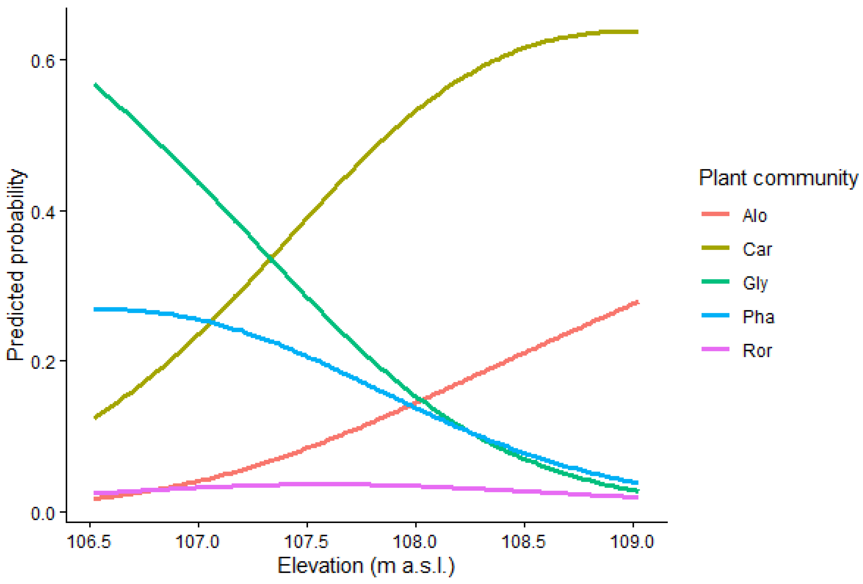
The elevational gradient further differentiated plant community distribution (Figure 6). Alopecuretum pratensis showed the highest probability at the highest elevations of the floodplain. Caricetum gracilis also increased with elevation, although less strongly than Alopecuretum pratensis. In contrast, Glycerietum maximae and Phalaridetum arundinaceae were most probable at lower elevations and declined upslope. Rorippo-Agrostietum showed low probabilities across the entire elevational range, with only minor variation along this gradient.

4. Discussion

Our results show that temporary floodplain ponds (TFPs) constitute a transient but ecologically important component of floodplain hydrology, exerting strong control over vegetation patterns at fine spatial scales. Shortly after spring flood recession, TFPs occupied more than 32% of the floodplain surface and stored on average over 250 L m−2 of surface water but disappeared within a month. Although short-lived, these water bodies were strongly linked to vegetation distribution, as indicated by the highly significant global chi-square test and the moderate-to-strong effect size. This suggests that TFPs represent a distinct post-flood hydrological phase that extends the ecological influence of flooding beyond the flood peak itself. Similar studies conducted at broader spatial scales have shown that seasonal surface water storage plays a major role in floodplain functioning and in regulating hydrological exchange between rivers and wetlands, although these analyses have usually focused on basin- or floodplain-scale storage rather than small-scale residual ponding features [30,31,32].
Although the geomorphological setting of the Biebrza valley is specific, the ecological role of TFPs identified in this study is consistent with patterns reported from other short-hydroperiod systems. Temporary ponds and vernal pools are likewise structured by alternating flooding and drying phases and by strong seasonal environmental variability. Mediterranean temporary ponds support distinct plant communities whose composition reflects hydrological conditions and habitat characteristics, which makes them useful for wetland typology and conservation assessment [33]. Long-term work on vernal pools has also shown that plant community composition depends strongly on appropriate hydrological conditions, especially inundation depth and duration, and that hydrology is a necessary foundation for maintaining characteristic vegetation [34]. Comparable mechanisms have been reported outside Europe as well. In temporary ponds, community assembly and disassembly track successive wet phases during inundation–desiccation cycles, indicating that short-lived hydrological stages can structure biological communities at fine temporal scales [35]. In arid wetlands, vegetation dynamics have been linked to water depth, inundation frequency, and exceedance time [36]. Studies from large Chinese floodplain and riparian wetlands similarly indicate that flooding depth, flooding duration, and inundation frequency are important predictors of vegetation zonation and landscape structure [37,38]. Taken together, these studies suggest that the TFPs documented in the Biebrza valley represent a floodplain-specific expression of a more general ecological phenomenon: transient shallow water bodies extend wet-phase conditions beyond the main flood event and act as fine-scale hydrological filters shaping vegetation patterns.
The ecological significance of TFPs in our study was expressed not only in their areal extent and water volume, but also in their selective relationship with plant communities. The results show that TFPs did not affect all communities equally. Instead, they acted as a community-specific hydrological filter. Rorippo-Agrostietum showed the strongest dependence on TFP depth, with probability of occurrence rising continuously along the inundation gradient and remaining near zero under dry conditions. In contrast, Glycerietum maximae and Caricetum gracilis also responded positively to TFP depth, but unlike Rorippo-Agrostietum, they were already frequent under less inundated conditions and became more probable when TFPs were present. By comparison, Alopecuretum pratensis and Phalaridetum arundinaceae declined with increasing TFP depth, indicating that TFPs limited their occurrence rather than promoted it. These results are consistent with earlier studies showing that flood depth, duration and hydroperiod structure plant zonation by favoring communities with contrasting inundation tolerances [39,40,41].
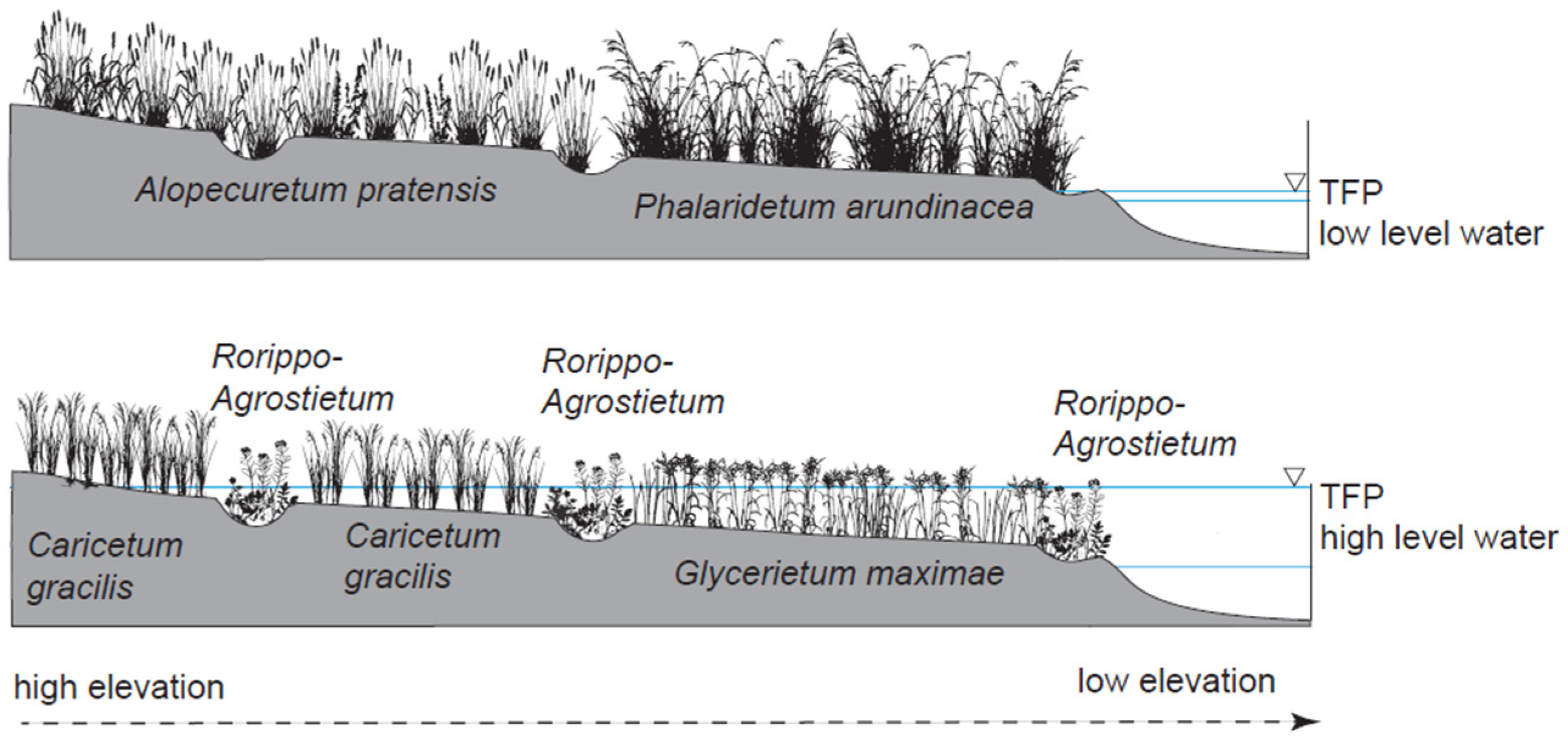
The predicted probability curves revealed that TFP depth and elevation jointly produced contrasting vegetation configurations within the valley, which are summarized in the conceptual model proposed in Figure 7. Two opposing pairs of communities can be distinguished. The first pair consists of Alopecuretum pratensis and Phalaridetum arundinaceae, both negatively associated with TFPs, but occupying different topographic positions. Alopecuretum was associated mainly with the highest parts of the floodplain, whereas Phalaridetum occurred lower in the valley but still declined with increasing TFP depth. The second pair consists of Caricetum gracilis and Glycerietum maximae, both positively associated with TFPs, but occupying different elevational zones: Caricetum at relatively higher elevations and Glycerietum in the lowest parts of the floodplain. Rorippo-Agrostietum differed from all other communities in being weakly structured by elevation but strongly tied to local water-filled depressions. Thus, under conditions of low TFP occurrence, the floodplain is dominated by communities associated with relatively dry or rapidly draining habitats, especially Alopecuretum pratensis and Phalaridetum arundinaceae, whereas under conditions of high TFP occurrence, moisture-dependent communities such as Caricetum gracilis and Glycerietum maximae expand, while Rorippo-Agrostietum occupies local depressions where water accumulates. Together, these patterns support the idea of fine-scale hydrological niche differentiation, in which subtle differences in water retention rather than broad floodplain position determine community occurrence, consistent with previous studies highlighting the role of small-scale hydrological heterogeneity and hydroperiod gradients in structuring wetland and floodplain vegetation [42,43,44].
The strong effects of elevation and slope further emphasize the importance of microtopography in regulating TFP persistence. Elevation separated communities along the main valley gradient, whereas TFP depth captured the effect of local water accumulation. Slope was less influential than TFP depth and elevation, but still significant, indicating that even subtle differences in local relief contribute to vegetation differentiation. This agrees with studies demonstrating that microtopography is a fundamental organizing structure in wetlands because it controls water table position, ponding, and the distribution of saturated versus drained microsites [44,45]. In low-gradient floodplains, these small differences in surface elevation can produce large ecological effects by modulating the duration of shallow inundation and the spatial continuity of wet habitats.
The vegetation classification results also provide important ecological context. The best discrimination was obtained for Nupharo-Nymphaeetum and Phalaridetum arundinaceae, whereas Rorippo-Agrostietum remained the most difficult community to classify even after combining SAR and multispectral data. This pattern is ecologically meaningful. The aquatic Nupharo-Nymphaeetum and the dense reed-dominated Phalaridetum form relatively large, homogeneous, and spatially aggregated patches, making them easier to identify in remotely sensed imagery. In contrast, Rorippo-Agrostietum is associated with shallow, transient depressions and small inundation patches that readily intermix with neighboring communities. Caricetum gracilis and Glycerietum maximae were also more difficult to distinguish than the most aggregated communities, likely because they occupy transitional hydrological settings. These results suggest that some of the environmental conditions controlling community formation operate at a finer spatial scale than the effective resolution of the classification inputs and derived products. The improvement obtained after adding Sentinel-2 data confirms that SAR and optical imagery provide complementary information, combining sensitivity to shallow water and vegetation structure with multispectral discrimination of plant communities. Similar improvements in wetland vegetation mapping have been reported in studies integrating SAR with optical or hyperspectral data [46,47,48].
An important implication of these results is that changes in TFP persistence may reorganize floodplain vegetation mosaics even without large shifts in overall flood extent. Because the occurrence probabilities of the studied communities respond differently to TFP depth and elevation, years with reduced TFP formation would be expected to favor communities such as Alopecuretum pratensis and Phalaridetum arundinaceae, while reducing the spatial importance of Rorippo-Agrostietum, Glycerietum maximae and, to some extent, Caricetum gracilis. Conversely, wetter years with more persistent TFPs should promote the expansion of moisture-dependent communities. This is consistent with studies showing that flood regime components, including depth, duration and recurrence, alter not only overall vegetation composition but also the abiotic correlates of riparian vegetation [42,49,50].
This makes TFPs particularly relevant in the context of climatic variability and changing hydrological regimes. Shorter snow cover duration, earlier flood recession and more rapid spring drying may reduce the duration of TFPs and thus weaken their filtering role. In such conditions, the floodplain mosaic may become more homogeneous and increasingly dominated by communities associated with drier or more rapidly draining conditions. Because our results show that even small differences in TFP depth are associated with strong shifts in vegetation probabilities, the ecological consequences of altered post-flood water retention may be substantial, especially in peatland river valleys where local storage processes shape habitat diversity.
Several limitations should be acknowledged. The analysis represents a single flooding season, and interannual variability in flood magnitude and timing may shift both the spatial extent of TFPs and the response of plant communities. This study prioritized field-based vegetation surveys over temporally denser vegetation mapping because syntaxonomic identification of floodplain plant communities requires floristic information that cannot be derived reliably from satellite data alone. Remote sensing was therefore used not to replace field surveys, but to extend them spatially and link community occurrence to TFP dynamics at the floodplain scale. In addition, the analysis focused on surface water and topographic controls, whereas groundwater dynamics, peat decomposition stage and seed bank processes were not explicitly incorporated. Future studies combining multi-year SAR series, repeated vegetation surveys and additional hydrological variables would allow a more complete assessment of the long-term role of TFPs in structuring floodplain ecosystems.
Estimates of retained water depth and volume are subject to uncertainty associated with the accuracy of the LiDAR-derived DEM. Previous validation of ISOK airborne laser scanning data in the Widawa River valley reported mean elevation errors ranging from 3 to 20 cm for natural surfaces, depending on surface roughness [51]. Although these values do not constitute a direct validation of the DEM used in the present study, they indicate the potential magnitude of elevation uncertainty. In areas covered by dense meadow vegetation, limited penetration of laser pulses may lead to an overestimation of ground elevation. Because water depth was estimated relative to the DEM-derived terrain surface within inundated patches, vertical DEM errors propagate directly into depth and volume estimates and may lead to their underestimation. Therefore, the mean water retention exceeding 250 L/m2 should be regarded as an approximate value [52].

5. Conclusions

Temporary floodplain ponds (TFPs) were shown to be a highly dynamic component of floodplain hydrology, occupying more than 32% of the valley surface shortly after flood recession and storing, on average, over 250 L m−2 of surface water. Although short-lived, these features created strong early-season hydrological heterogeneity across the floodplain.
The integration of SAR and optical imagery substantially improved vegetation mapping accuracy, demonstrating that remote sensing data fusion is effective for identifying fine-scale vegetation mosaics associated with TFPs.
Our results further showed that TFP depth was a key factor shaping plant community distribution: Rorippo-Agrostietum, Caricetum gracilis and Glycerietum maximae were positively associated with increasing TFP depth, whereas Alopecuretum pratensis and Phalaridetum arundinaceae declined along the same gradient.
These findings indicate that TFPs act as a fine-scale hydrological filter structuring floodplain vegetation patterns, and that changes in their persistence may shift the balance between moisture-dependent and better-drained plant communities.

Author Contributions

Conceptualization, M.M. (Marek Mróz), P.S. and P.A.; methodology, P.A.; software, P.A.; validation, S.S.-W., M.M. (Magdalena Mleczko) and P.A.; formal analysis, P.A.; investigation, P.A.; resources, D.S. and P.S.; data curation, P.A.; writing—original draft preparation, P.A.; writing—review and editing, P.S., M.M. (Marek Mróz), M.M. (Magdalena Mleczko) and S.S.-W.; visualization, P.A.; supervision, P.S. All authors have read and agreed to the published version of the manuscript.

Funding

This research received no external funding.

Data Availability Statement

The data presented in this study are available on request from the corresponding author.

Conflicts of Interest

The authors declare no conflicts of interest.

References

  1. Kumar, L.; Deitch, M.J.; Amanambu, A.C.; Jones Pe, W.K.; Walls, S.; Sharma, A.; Mossa, J.; Gebremicael, T.G.; Kumari, R. Restoration Impacts on Distributary Slough Floodplain Inundation and Connectivity. Ecol. Eng. 2026, 222, 107808. [Google Scholar] [CrossRef]
  2. Nummi, M.; Nummi, P.; Holopainen, S.; Davranche, A.; Sigdel, U.; Arzel, C. Which Natural Wetland Characteristics Could Be Used in Creating Temporary Wetlands? Wetlands 2024, 44, 100. [Google Scholar] [CrossRef]
  3. Amoros, C.; Bornette, G. Connectivity and Biocomplexity in Waterbodies of Riverine Floodplains. Freshw. Biol. 2002, 47, 761–776. [Google Scholar] [CrossRef]
  4. Junk, W.J.; Bayley, P.B.; Sparks, R.E. The Flood Pulse Concept in River-Floodplain Systems. Can. Spec. Publ. Fish. Aquat. Sci. 1989, 106, 110–127. [Google Scholar]
  5. Olmo, C.; Gálvez, Á.; Bisquert-Ribes, M.; Bonilla, F.; Vega, C.; Castillo-Escrivà, A.; De Manuel, B.; Rueda, J.; Sasa, M.; Ramos-Jiliberto, R.; et al. The Environmental Framework of Temporary Ponds: A Tropical-Mediterranean Comparison. CATENA 2022, 210, 105845. [Google Scholar] [CrossRef]
  6. Chandler, H.C.; McLaughlin, D.L.; Haas, C.A. Informing the Conservation of Ephemerally Flooded Wetlands Using Hydrologic Regime and LiDAR-Based Habitat Assessments. Wetlands 2024, 44, 33. [Google Scholar] [CrossRef]
  7. Dixneuf, C.; Peiris, P.; Nummi, P.; Sundell, J. Vernal Pools Enhance Local Vertebrate Activity and Diversity in a Boreal Landscape. Glob. Ecol. Conserv. 2021, 31, e01858. [Google Scholar] [CrossRef]
  8. Åhlén, I.; Jarsjö, J.; Hambäck, P.A. Connecting Wetland Flooding Patterns to Insect Abundance Using High-Resolution Inundation Frequency Data. Wetlands 2023, 43, 74. [Google Scholar] [CrossRef]
  9. Chanut, P.C.M.; Burdon, F.J.; Datry, T.; Robinson, C.T. Convergence in Floodplain Pond Communities Indicates Different Pathways to Community Assembly. Aquat. Sci. 2023, 85, 59. [Google Scholar] [CrossRef] [PubMed]
  10. Monge-Salazar, M.J. The Effect of Artisanal Gold Mining on Aquatic Insect Communities: A Case Study in Costa Rica. Aquat. Insects 2021, 42, 160–178. [Google Scholar] [CrossRef]
  11. Pratt, O.P.; Beesley, L.S.; Pusey, B.J.; Gwinn, D.C.; Keogh, C.S.; Douglas, M.M. Brief Floodplain Inundation Provides Growth and Survival Benefits to a Young-of-Year Fish in an Intermittent River Threatened by Water Development. Sci. Rep. 2023, 13, 17725. [Google Scholar] [CrossRef] [PubMed]
  12. d’Araújo Couto, T.B.; Zuanon, J.; Olden, J.D.; Ferraz, G. Longitudinal Variability in Lateral Hydrologic Connectivity Shapes Fish Occurrence in Temporary Floodplain Ponds. Can. J. Fish. Aquat. Sci. 2018, 75, 319–328. [Google Scholar] [CrossRef]
  13. Huang, A.; Liu, X.; Peng, W.; Dong, F.; Han, Z.; Du, F.; Ma, B.; Wang, W. Spatiotemporal Heterogeneity of Inundation Pattern of Floodplain Lake Wetlands and Impact on Wetland Vegetation. Sci. Total Environ. 2023, 905, 167831. [Google Scholar] [CrossRef] [PubMed]
  14. Zhao, Y.; Samat, A.; Du, P.; Luo, K.; Zhu, E.; Li, W. Remote Sensing of Non-Intertidal Wetlands: An Overview of Current Status and Future Research Directions. J. Geovis. Spat. Anal. 2026, 10, 7. [Google Scholar] [CrossRef]
  15. Zhang, Y.; Lin, X.; Hei, J.; Wang, Y.; Zhang, A. Multiscale Remote Sensing Methods for Monitoring Wetland Ecosystem Dynamics and Crop Development. Front. Environ. Sci. 2025, 13, 1626025. [Google Scholar] [CrossRef]
  16. Yuan, S.; Liang, X.; Lin, T.; Chen, S.; Liu, R.; Wang, J.; Zhang, H.; Gong, P. A Comprehensive Review of Remote Sensing in Wetland Classification and Mapping. arXiv 2025, arXiv:2504.10842. [Google Scholar]
  17. Pillai, L.G.; Dolly, D.R.J. Flood Detection Using SAR Images: A Review. AIP Conf. Proc. 2024, 3059, 020001. [Google Scholar] [CrossRef]
  18. Wdowinski, S.; Kim, S.-W.; Amelung, F.; Dixon, T. Wetland InSAR: A New Space-Based Hydrological Monitoring Tool of Wetlands Surface Water Level Changes; European Space Agency: Frescati, Italy, 2006; Volume SP-634. [Google Scholar]
  19. Patel, P.; Srivastava, H.S.; Panigrahy, S.; Parihar, J.S. Comparative Evaluation of the Sensitivity of Multi-polarized Multi-frequency SAR Backscatter to Plant Density. Int. J. Remote Sens. 2006, 27, 293–305. [Google Scholar] [CrossRef]
  20. Banaszuk, H. Charakterystyka gleb Biebrzańskiego Parku Narodowego. In Kotlina Biebrzańska i Biebrzański Park Narodowy. Aktualny Stan Walory Zagrożenia i Potrzeby Czynnej Ochrony Środowiska; Wydawnictwo Ekonomia i Srodowisko: Białystok, Poland, 2004; pp. 265–290. [Google Scholar]
  21. Grygoruk, M.; Batelaan, O.; Okruszko, T.; Mirosław-Świątek, D.; Chormański, J.; Rycharski, M. Groundwater Modelling and Hydrological System Analysis of Wetlands in the Middle Biebrza Basin. In Modelling of Hydrological Processes in the Narew Catchment; Świątek, D., Okruszko, T., Eds.; Springer: Berlin/Heidelberg, Germany, 2011; pp. 89–109. ISBN 978-3-642-19059-9. [Google Scholar]
  22. Braun-Blanquet, J. Pflanzensoziologie: Grundzüge der Vegetationskunde; Springer: Berlin/Heidelberg, Germany, 2013; ISBN 3-7091-4078-1. [Google Scholar]
  23. Matuszkiewicz, W. Przewodnik do Oznaczania Zbiorowisk Roslinnych Polski; Wydawnictwo Naukowe PWN: Warszawa, Poland, 2017; ISBN 978-83-01-16707-3. [Google Scholar]
  24. Liang, J.; Liu, D. A Local Thresholding Approach to Flood Water Delineation Using Sentinel-1 SAR Imagery. ISPRS J. Photogramm. Remote Sens. 2020, 159, 53–62. [Google Scholar] [CrossRef]
  25. LiDAR Data Poland/GUGIK. Available online: https://www.geoportal.gov.pl/pl/dane/dane-pomiarowe-lidar-lidar/ (accessed on 28 May 2026).
  26. Hijmans, R.J.; Brown, A.; Barbosa, M. Terra: Spatial Data Analysis 2020, 1.9-27. Available online: https://cran.r-project.org/web/packages/terra/index.html (accessed on 1 June 2026).
  27. Kuhn, M. Building Predictive Models in R Using the Caret Package. J. Stat. Soft. 2008, 28, 1–26. [Google Scholar] [CrossRef]
  28. Ripley, B. Nnet: Feed-Forward Neural Networks and Multinomial Log-Linear Models 2009, 7.3-20. Available online: https://cran.r-project.org/web/packages/nnet/nnet.pdf (accessed on 1 June 2026).
  29. Mangiafico, S. Rcompanion: Functions to Support Extension Education Program Evaluation 2016, 2.5.2. Available online: https://cran.r-project.org/web/packages/rcompanion/ (accessed on 1 June 2026).
  30. Kim, H.; Yeh, P.J.-F.; Oki, T.; Kanae, S. Role of Rivers in the Seasonal Variations of Terrestrial Water Storage over Global Basins. Geophys. Res. Lett. 2009, 36, 2009GL039006. [Google Scholar] [CrossRef]
  31. Alsdorf, D.; Han, S.-C.; Bates, P.; Melack, J. Seasonal Water Storage on the Amazon Floodplain Measured from Satellites. Remote Sens. Environ. 2010, 114, 2448–2456. [Google Scholar] [CrossRef]
  32. Papa, F.; Frappart, F. Surface Water Storage in Rivers and Wetlands Derived from Satellite Observations: A Review of Current Advances and Future Opportunities for Hydrological Sciences. Remote Sens. 2021, 13, 4162. [Google Scholar] [CrossRef]
  33. Pinto-Cruz, C.; Molina, J.A.; Barbour, M.; Silva, V.; Espírito-Santo, M.D. Plant Communities as a Tool in Temporary Ponds Conservation in SW Portugal. Hydrobiologia 2009, 634, 11–24. [Google Scholar] [CrossRef]
  34. Collinge, S.K.; Ray, C.; Marty, J.T. A Long-Term Comparison of Hydrology and Plant Community Composition in Constructed versus Naturally Occurring Vernal Pools. Restor. Ecol. 2013, 21, 704–712. [Google Scholar] [CrossRef]
  35. Florencio, M.; Gómez-Rodríguez, C.; Serrano, L.; Díaz-Paniagua, C. Competitive Exclusion and Habitat Segregation in Seasonal Macroinvertebrate Assemblages in Temporary Ponds. Freshw. Sci. 2013, 32, 650–662. [Google Scholar] [CrossRef]
  36. Sandi, S.G.; Saco, P.M.; Kuczera, G.; Wen, L.; Saintilan, N.; Rodriguez, J.F. Predicting Floodplain Inundation and Vegetation Dynamics in Arid Wetlands. E3S Web Conf. 2018, 40, 02019. [Google Scholar] [CrossRef]
  37. Yi, X.; Huang, Y.; Jiang, Y.; Ma, M.; Chen, Q.; Wu, S. Flooding Depth and Flooding Duration with the Zonation of Riparian Plant Communities in the Three Gorges Reservoir of China. Water 2023, 15, 3228. [Google Scholar] [CrossRef]
  38. Zhang, J.; Cheng, C. Response Patterns of Wetland Vegetation Distribution to Changes in Inundation Processes in the Dongting Lake Wetland. Sustainability 2026, 18, 5991. [Google Scholar] [CrossRef]
  39. Murray-Hudson, M.; Wolski, P.; Murray-Hudson, F.; Brown, M.T.; Kashe, K. Disaggregating Hydroperiod: Components of the Seasonal Flood Pulse as Drivers of Plant Species Distribution in Floodplains of a Tropical Wetland. Wetlands 2014, 34, 927–942. [Google Scholar] [CrossRef]
  40. Lan, Z.; Chen, Y.; Shen, R.; Cai, Y.; Luo, H.; Jin, B.; Chen, J. Effects of Flooding Duration on Wetland Plant Biomass: The Importance of Soil Nutrients and Season. Freshw. Biol. 2021, 66, 211–222. [Google Scholar] [CrossRef]
  41. Wang, Y.; Min, J.; Li, Z.; Cao, Y.; Huang, L.; Chen, C. Influence of Different Flooding Depth on Wetland Plant Phalaris arundinacea. J. Freshw. Ecol. 2024, 39, 2429564. [Google Scholar] [CrossRef]
  42. Steinberg, K.A.; Eichhorst, K.D.; Rudgers, J.A. Flood Regime Alters the Abiotic Correlates of Riparian Vegetation. Appl. Veg. Sci. 2021, 24, e12572. [Google Scholar] [CrossRef]
  43. García-Baquero Moneo, G.; Gowing, D.J.G.; Wallace, H. The Contribution of the Spatial Hydrological Niche to Species Diversity in Rare Plant Communities of English Floodplain Meadows. Plant Ecol. 2022, 223, 599–612. [Google Scholar] [CrossRef]
  44. Diamond, J.S.; McLaughlin, D.L.; Slesak, R.A.; Stovall, A. Microtopography Is a Fundamental Organizing Structure of Vegetation and Soil Chemistry in Black Ash Wetlands. Biogeosciences 2020, 17, 901–915. [Google Scholar] [CrossRef]
  45. Choi, J.; Harvey, J.W. Relative Significance of Microtopography and Vegetation as Controls on Surface Water Flow on a Low-Gradient Floodplain. Wetlands 2014, 34, 101–115. [Google Scholar] [CrossRef]
  46. Hess, L.L.; Melack, J.M. Remote Sensing of Vegetation and Flooding on Magela Creek Floodplain (Northern Territory, Australia) with the SIR-C Synthetic Aperture Radar. Hydrobiologia 2003, 500, 65–82. [Google Scholar] [CrossRef]
  47. Fu, B.; Xie, S.; He, H.; Zuo, P.; Sun, J.; Liu, L.; Huang, L.; Fan, D.; Gao, E. Synergy of Multi-Temporal Polarimetric SAR and Optical Image Satellite for Mapping of Marsh Vegetation Using Object-Based Random Forest Algorithm. Ecol. Indic. 2021, 131, 108173. [Google Scholar] [CrossRef]
  48. Liang, Y.; Zhang, L.; Xiong, S.; You, L.; He, Z.; Huang, Y.; Lu, J. C-Band Synthetic Aperture Radar Time-Series for Mapping of Wetland Plant Communities in China’s Largest Freshwater Lake. J. Appl. Rem. Sens. 2024, 19, 021006. [Google Scholar] [CrossRef]
  49. Gui, H.; Hou, L.; Wang, J.; Dong, X.; Han, S. Flood Changed the Community Composition and Increased the Importance of Stochastic Process of Vegetation and Seed Bank in a Riparian Ecosystem of the Yellow River. Ecol. Indic. 2023, 154, 110505. [Google Scholar] [CrossRef]
  50. Li, X.; Yi, W.; Duan, X.; Chen, G.; Yang, J.; Deng, D.; Guo, X.; Yang, Z.; Huang, G.; Hu, M.; et al. Anti-Seasonal Flooding Drive Substantial Alterations in Riparian Plant Diversity and Niche Characteristics in a Unique Hydro-Fluctuation Zone. Ecol. Evol. 2024, 14, e70036. [Google Scholar] [CrossRef]
  51. Pawłuszek, K.; Ziaja, M.; Borkowski, A. Ocena Dokładności Wysokościowej Danych Lotniczego Skaningu Laserowego Systemu Isok Na Obszarze Doliny Rzeki Widawy. Acta Sci. Pol. 2014, 27–38. [Google Scholar]
  52. Kiczko, A.; Mirosław-Świątek, D. Impact of Uncertainty of Floodplain Digital Terrain Model on 1D Hydrodynamic Flow Calculation. Water 2018, 10, 1308. [Google Scholar] [CrossRef]
Figure 1. Location of the research area and sites of remote sensing and botanical data acquisition.
Remotesensing 18 02292 g001
Figure 2. Raster histograms for SAR scenes (preflood, right after flood, during summer).
Remotesensing 18 02292 g002
Figure 3. Seasonal dynamics of temporary floodplain ponds (TFPs) during spring and early summer 2015, derived from HH-polarized TerraSAR-X imagery using threshold-based classification.
Remotesensing 18 02292 g003
Figure 4. Spatial distribution of classified wetland plant communities across the entire study area.
Remotesensing 18 02292 g004
Figure 5. Predicted plant community occurrence along the TFP depth gradient.
Remotesensing 18 02292 g005
Figure 6. Predicted plant community occurrence along the floodplain elevation gradient.
Remotesensing 18 02292 g006
Figure 7. Conceptual model of vegetation patterns under contrasting temporary floodplain pond (TFP) conditions.
Remotesensing 18 02292 g007
Table 1. Distinguished plant communities with corresponding numbers of research points.
Plant CommunityDescriptionNumber of Research Points
Alopecuretum pratensis [Alo]Highly productive meadows dominated by Alopecurus pratensis that mainly occur in the floodplains of large lowland rivers as well as in broad floodplains26
Caricetum gracilis [Car]Marsh-type vegetation is dominated by the tall sedge Carex gracilis in shallow, eutrophic wetlands such as in the littoral zones of fishponds, water reservoirs, oxbows, alluvial pools, fish storage ponds, riverbanks, ditches and shallow depressions in meadows52
Glycerietum maximae [Gly]Marsh-type vegetation is dominated by Glyceria maxima, a 1–2 m tall grass, occurs in shallow water in eutrophic to hypertrophic wetlands55
Nupharo-Nymphaeetum [Num]Water vegetation type dominated by Nuphar lutea, which usually has large leaves that float on the water surface, but in flowing or deep still water, it produces only submerged leaves16
Phalaridetum arundinaceae [Pha]Vegetation with dense stands of Phalaris arundinacea, occurring in complexes of marsh vegetation in lowland river floodplains and in the littoral zones of still water bodies29
Rorippo-Agrostietum [Ror]Vegetation dominated by Rorippa amphibia, occurs in oxbows, alluvial pools, ditches, channels on fluvial sediment accumulations and in lentic sections of rivers22
Table 2. Classification metrics.
SARSAR + Multispectral
Plant CommunitySensitivitySpecificityAccuracySensitivitySpecificityAccuracy
Alopecuretum pratensis [Alo].0.4750.9680.7210.8900.9890.940
Caricetum gracilis [Car]0.6310.8660.7490.7300.9720.851
Glycerietum maximae [Gly]0.7110.8130.7620.8260.8870.857
Nupharo-Nymphaeetum [Num]0.9990.9950.9970.8970.9990.948
Phalaridetum arundinaceae [Pha]0.7150.9530.8330.9300.9620.946
Rorippo-Agrostietum [Ror]0.3400.9800.6600.6290.9730.801
Overall accuracy0.6450.817
Kappa0.5740.780
F10.6430.819
Table 3. Relationship between vegetation and TFPs.
Plant Communityχ2p-ValueCramér’s V
Alopecuretum pratensis [Alo]52.76<0.0010.199
Caricetum gracilis [Car]1.440.2300.034
Glycerietum maximae [Gly]95.67<0.0010.266
Phalaridetum arundinaceae [Pha]116.76<0.0010.294
Rorippo-Agrostietum [Ror]14.49<0.0010.106
Table 4. Global predictors of plant community distribution.
Predictorχ2p-Value
TFP depth (m)143.53<0.001
Elevation (m ASL)50.66<0.001
Slope (°)28.66<0.001
Distance to river (m)10.470.033
Distance to nearest oxbow lake (m)9.390.052
Table 5. Community-specific responses to TFP depth, elevation and slope derived from multinomial logistic regression.
Plant CommunityPredictorOR95% CI
Caricetum gracilis [Car]TFP depth (m)2.181.65–2.88
Elevation (m ASL)0.630.62–0.63
Slope (°)1.060.94–1.20
Glycerietum maximae [Gly]TFP depth (m)2.211.67–2.93
Elevation (m ASL)0.100.10–0.10
Slope (°)1.141.01–1.28
Phalaridetum arundinaceae [Pha]TFP depth (m)0.870.64–1.18
Elevation (m ASL)0.150.15–0.15
Slope (°)1.211.08–1.36
Rorippo-Agrostietum [Ror]TFP depth (m)3.102.15–4.47
Elevation (m ASL)0.300.29–0.30
Slope (°)1.100.93–1.29
Disclaimer/Publisher’s Note: The statements, opinions and data contained in all publications are solely those of the individual author(s) and contributor(s) and not of MDPI and/or the editor(s). MDPI and/or the editor(s) disclaim responsibility for any injury to people or property resulting from any ideas, methods, instructions or products referred to in the content.