Comparative Analysis of Near-Storm Environmental Characteristics of Tornadoes in Northern and Southern China Based on Himawari-8 Satellite and ERA5 Data
 , , ,
, , ,
Highlights
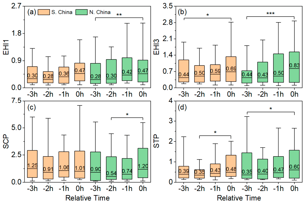
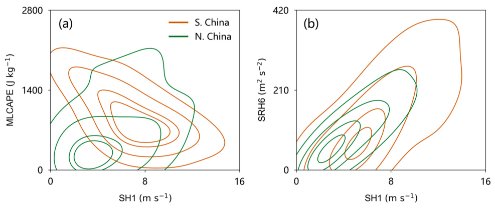
- A clear regional difference exists in Chinese tornadogenesis. Southern tornadoes are “dynamically driven” in moist environments. Northern tornadoes follow a “coupled thermodynamic-kinematic” paradigm requiring substantial instability accumulation.
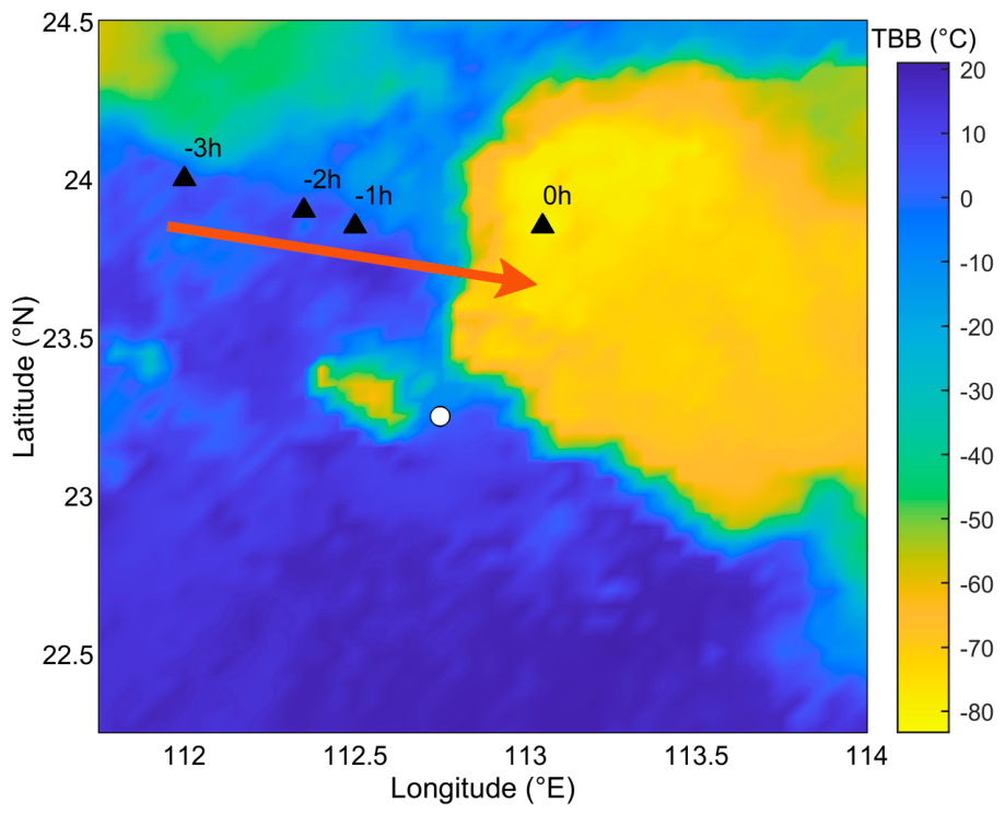
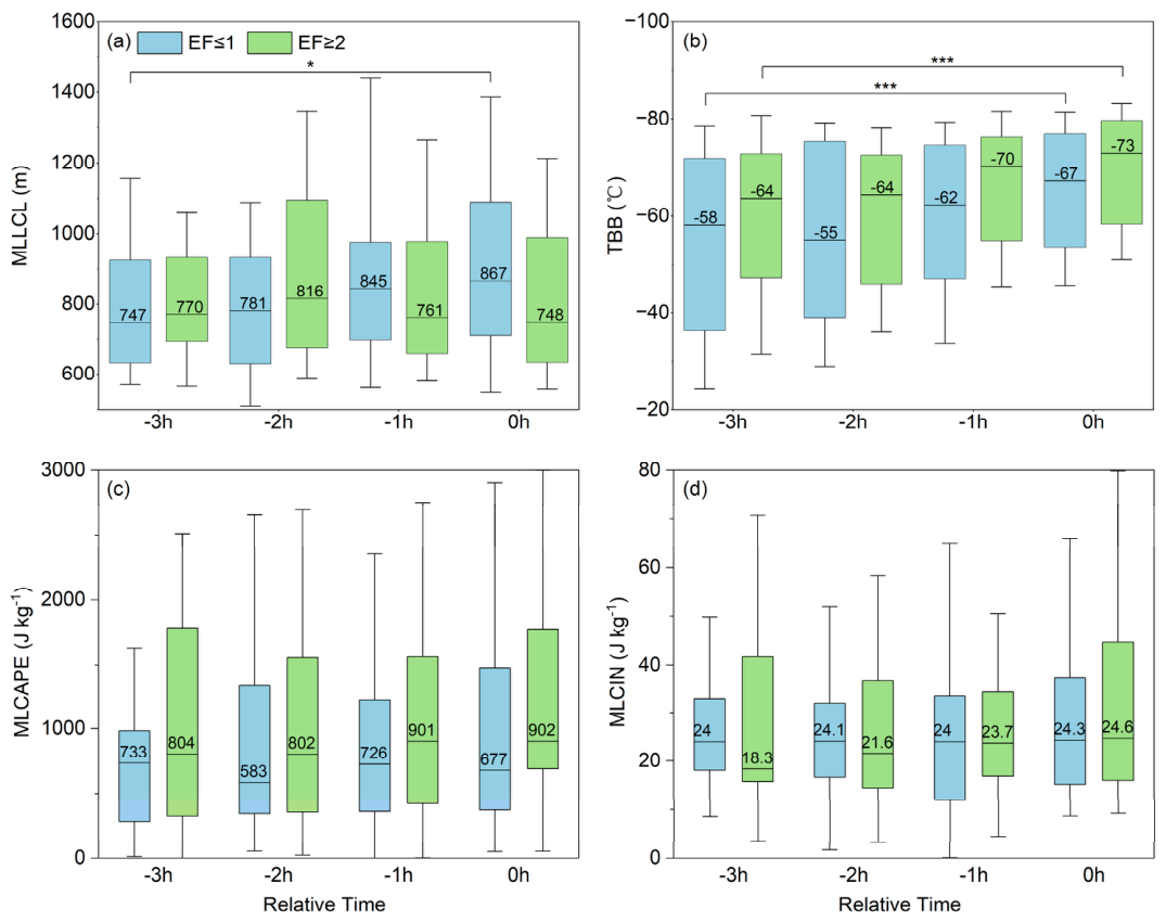
- Significant tornadoes (EF ≥ 2) exhibit distinct pre-storm vertical stretching signatures. These signatures are captured by rapid Himawari-8 satellite cloud-top cooling (TBB ≤ −73 °C).
- Combining high-frequency geostationary satellite observations with atmospheric reanalysis mitigates ground-radar blind spots. This approach provides a method for continuously monitoring pre-tornadic severe convective storms.
- The temporal intensification of environmental indices provides reliable, quantitative precursor signals for short-term nowcasting. This highlights the need to regionally recalibrate operational tornado warning thresholds in China.
Abstract
1. Introduction
2. Data and Method
2.1. Tornado Event Data
2.2. Atmospheric Environmental Parameters
2.3. Identification of Tornadic Convective Centers
3. Results
3.1. Comparative Analysis of Near-Storm Environmental Parameters Between Northern and Southern China
3.1.1. Thermodynamic Parameters
3.1.2. Kinematic Parameters
3.1.3. Composite Parameters
3.2. Comparative Analysis of Near-Storm Environmental Parameters Between Significant and Weak Tornadoes
4. Discussion
5. Conclusions
- (1)
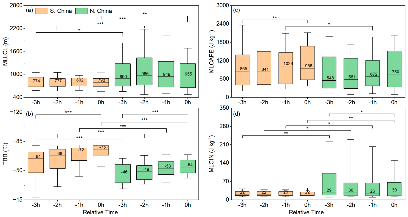
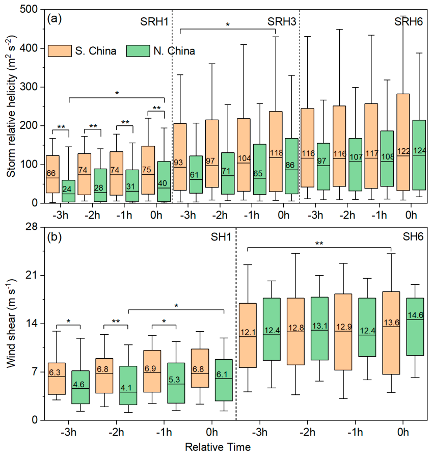
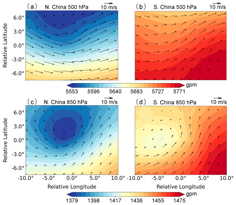
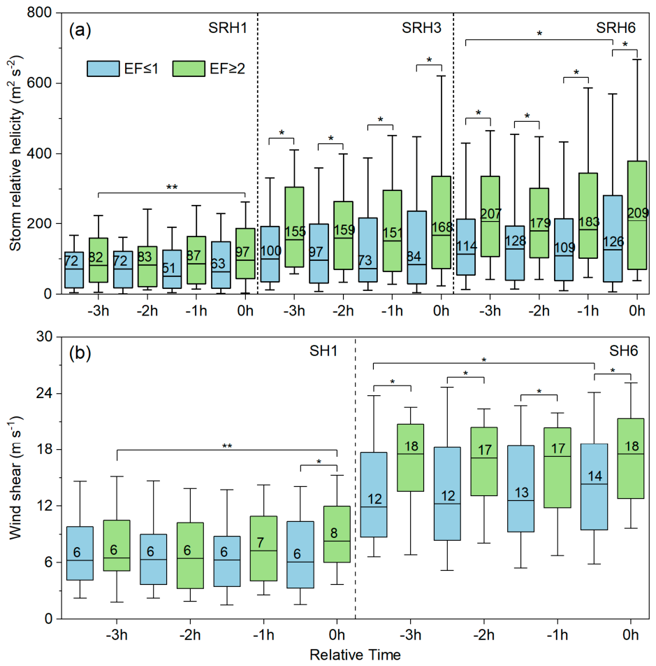
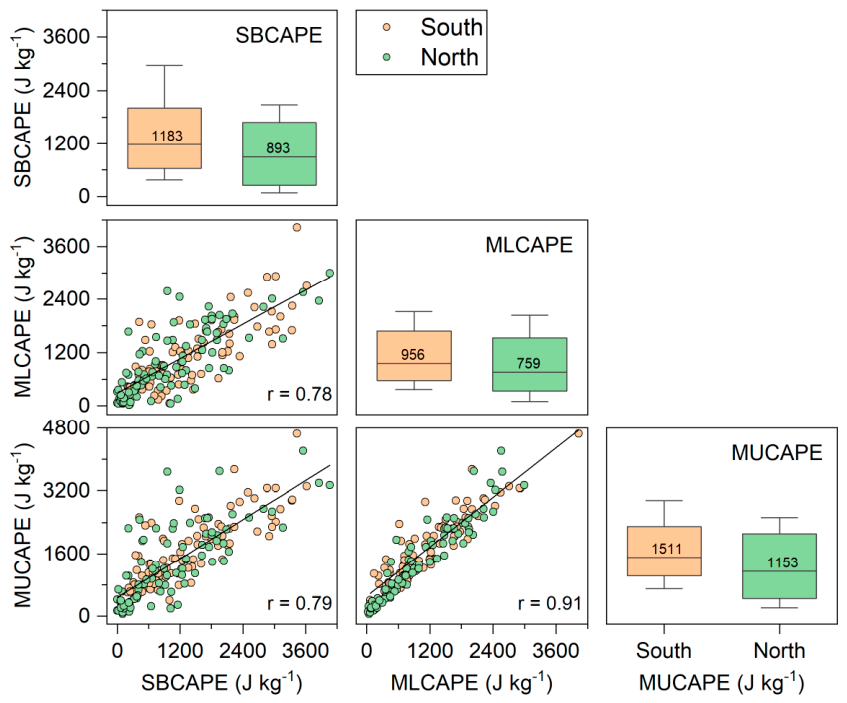
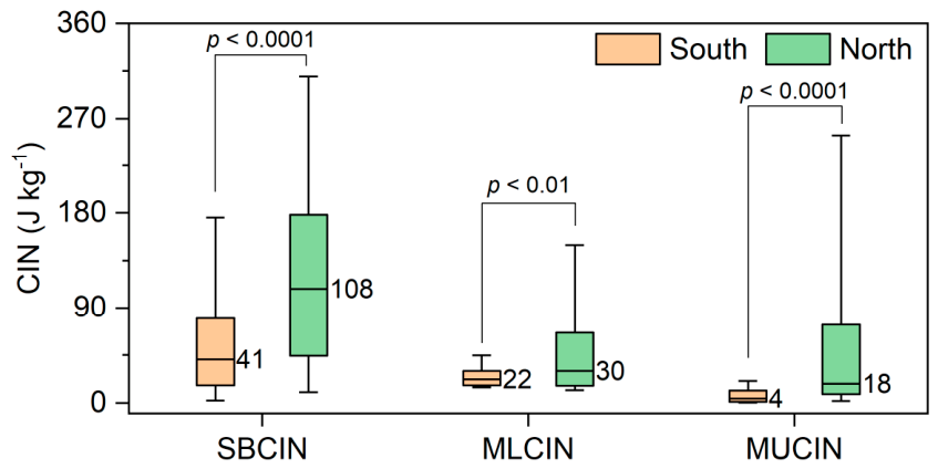
- Difference in Regional Environmental Paradigms: Tornadogenesis in China fol-lows two distinctly divergent regional mechanisms. Southern tornadoes are “dynamically driven,” occurring in humid conditions with minimal CIN and low MLLCL (median: 790 m). Their genesis is dominated by strong low-level kinematics (SH1 and SRH1). In con-trast, northern tornadoes follow a “coupled thermodynamic-kinematic” paradigm. Gov-erned by deep cold vortices, they occur in drier environments with higher CIN (median: 30 J kg−1), acting as a natural filter. Their triggering relies on the rapid, concurrent amplification of MLCAPE (increasing by ~211 J kg−1 within 3 h) and deep-layer kinematics (SRH6 and SH6) shortly before tornadogenesis.
- (2)
- Environmental Precursors for Significant Tornadoes: Significant tornadoes (EF ≥ 2) occur in superior parameter spaces compared to weak tornadoes (EF ≤ 1). Thermodynam-ically, strong tornadoes possess much higher MLCAPE (median: 902 vs. 677 J kg−1) and feature a unique pre-storm boundary layer moistening process, evidenced by a noticeable drop in MLLCL coupled with rapidly cooling cloud tops captured by satellite (TBB ≤ −73 °C). Kinematically, they require stronger deep-layer shear (SH6 median: 18 m s−1) and deep-layer helicity (SRH6 median: 209 m2 s−2).
- (3)
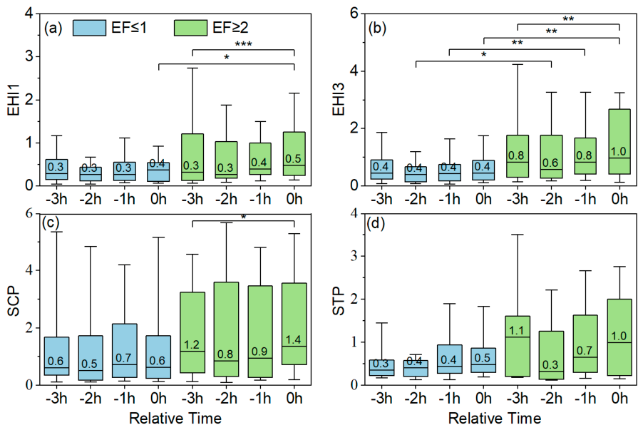
- Nowcasting Value of Satellite Data and Composite Parameters: The temporal rate of change serves as a critical predictor. The continuous pre-storm rapid cooling of Himawari-8 TBB captures the rapid vertical expansion of parent updrafts.
Author Contributions
Funding
Data Availability Statement
Acknowledgments
Conflicts of Interest
Abbreviations
| TBB | Cloud-top brightness temperature |
| LCL | Lifted Condensation Level |
| CIN | Convective Inhibition |
| SRH | Storm-relative helicity |
| SRH1 | SRH within the 0–1 km layers |
| SRH3 | SRH within the 0–3 km layers |
| SRH6 | SRH within the 0–6 km layers |
| CAPE | Convective available potential energy |
| MLCAPE | Mixed-Layer convective available potential energy |
| EF | Enhanced Fujita scale |
| EHI | Energy-Helicity Index |
| STP | Significant Tornado Parameter |
| SH | Vertical wind shear |
| SH1 | SH within the 0–1 km layers |
| SH3 | SH within the 0–3 km layers |
| SH6 | SH within the 0–6 km layers |
| SCP | Supercell Composite Parameter |
| HSLC | High-shear, low-CAPE |
| CMA | China Meteorological Administration |
| S. China | Southern China group |
| N. China | Northern China group |
| MLCIN | Mixed-Layer Convective Inhibition |
| TC | Tropical cyclone |
| KDE | Bivariate kernel density estimation |
| WNPSH | the western North Pacific subtropical high |
| LLJ | Low-level jet |
Appendix A


Appendix B

References
- Chen, J.; Cai, X.; Wang, H.; Kang, L.; Zhang, H.; Song, Y.; Zhu, H.; Zheng, W.; Li, F. Tornado climatology of China. Int. J. Climatol. 2018, 38, 2478–2489. [Google Scholar] [CrossRef] [Scilit]
- Zhu, W.; Sheng, J.; Zheng, Y.; Yang, B.; Zhang, X.; Fan, L.; Zhang, X.; Liu, X.; Cao, Y.; Lin, Y.; et al. Damage survey and mesoscale features analysis on tornado in outer rain-band of typhoon “Mujigae” on 4 October 2015. Torrential Rain Disasters 2016, 35, 403–414. (In Chinese) [Google Scholar] [CrossRef]
- Zhi, J.; Huang, X.; Bai, L.; Cai, K.; Li, C.; Li, Z.; Zhang, J.; Guan, L.; Sheng, J.; Zhou, K.; et al. Characteristics of Tornado Activity and Disaster of China in 2021. Adv. Meteorol. Sci. Technol. 2022, 12, 23–36. (In Chinese) [Google Scholar] [CrossRef]
- Yu, X.; Zhao, J.; Fan, W. Tornadoes in China: Spatiotemporal Distribution and Environmental Characteristics. J. Trop. Meteorol. 2021, 37, 681–692. (In Chinese) [Google Scholar] [CrossRef]
- Anderson-Frey, A.K.; Richardson, Y.P.; Dean, A.R.; Thompson, R.L.; Smith, B.T. Characteristics of Tornado Events and Warnings in the Southeastern United States. Weather Forecast. 2019, 34, 1017–1034. [Google Scholar] [CrossRef] [Scilit]
- Brooks, H.E.; Lee, J.W.; Craven, J.P. The spatial distribution of severe thunderstorm and tornado environments from global reanalysis data. Atmos. Res. 2003, 67–68, 73–94. [Google Scholar] [CrossRef] [Scilit]
- Sherburn, K.D.; Parker, M.D. Climatology and ingredients of significant severe convection in high-shear, low-CAPE environments. Weather Forecast. 2014, 29, 854–877. [Google Scholar] [CrossRef] [Scilit]
- Thompson, R.L.; Edwards, R.; Hart, J.A.; Elmore, K.L.; Markowski, P. Close proximity soundings within supercell environments obtained from the Rapid Update Cycle. Weather Forecast. 2003, 18, 1243–1261. [Google Scholar] [CrossRef] [Scilit]
- Thompson, R.L.; Smith, B.T.; Dean, A.R.; Marsh, P.T. Spatial distributions of tornadic near-storm environments by convective mode. E-J. Sev. Storm Meteorol. 2013, 8, e2022GL099894. [Google Scholar] [CrossRef] [Scilit]
- Coffer, B.E.; Parker, M.D.; Thompson, R.L.; Smith, B.T.; Jewell, R.E. Using Near-Ground Storm Relative Helicity in Supercell Tornado Forecasting. Weather Forecast. 2019, 34, 1417–1435. [Google Scholar] [CrossRef] [Scilit]
- Davies-Jones, R. Streamwise Vorticity: The Origin of Updraft Rotation in Supercell Storms. J. Atmos. Sci. 1984, 41, 2991–3006. [Google Scholar] [CrossRef] [Scilit]
- Qie, X.; Qie, K.; Wei, L.; Zhu, K.; Sun, Z.; Yuan, S.; Jiang, R.; Zhang, H.; Xu, C. Significantly Increased Lightning Activity Over the Tibetan Plateau and Its Relation to Thunderstorm Genesis. Geophys. Res. Lett. 2022, 49, e2022GL099894. [Google Scholar] [CrossRef] [Scilit]
- Qie, X.; Toumi, R.; Yuan, T. Lightning activities on the Tibetan Plateau as observed by the lightning imaging sensor. J. Geophys. Res. Atmos. 2003, 108. [Google Scholar] [CrossRef] [Scilit]
- Weisman, M.L.; Klemp, J.B. The dependence of numerically simulated convective storms on vertical wind shear and buoyancy. Mon. Weather Rev. 1982, 110, 504–520. [Google Scholar] [CrossRef] [Scilit]
- Rasmussen, E.N. Refined supercell and tornado forecast parameters. Weather Forecast. 2003, 18, 530–535. [Google Scholar] [CrossRef] [Scilit]
- Rasmussen, E.N.; Blanchard, D.O. A baseline climatology of sounding-derived supercell andtornado forecast parameters. Weather Forecast. 1998, 13, 1148–1164. [Google Scholar] [CrossRef] [Scilit]
- Anderson-Frey, A.K.; Richardson, Y.P.; Dean, A.R.; Thompson, R.L.; Smith, B.T. Investigation of Near-Storm Environments for Tornado Events and Warnings. Weather Forecast. 2016, 31, 1771–1790. [Google Scholar] [CrossRef] [Scilit]
- Taszarek, M.; Pilguj, N.; Allen, J.T.; Gensini, V.; Brooks, H.E.; Szuster, P. Comparison of convective parameters derived from ERA5 and MERRA-2 with rawinsonde data over Europe and North America. J. Clim. 2021, 34, 3211–3237. [Google Scholar] [CrossRef] [Scilit]
- Zheng, Y. Review of Climatology and Favorable Environmental Conditions of Tornado in China. Adv. Meteorol. Sci. Technol. 2020, 10, 67–75. (In Chinese) [Google Scholar] [CrossRef]
- Huang, X.; Bai, L.; Yan, L.; Zhang, Z.; Cai, K.; Zhi, J. Climatic characteristics and environmental conditions of the tornado occurrences within tropical cyclones over Guangdong province, China. Acta Meteorol. Sin. 2024, 82, 319–339. (In Chinese) [Google Scholar] [CrossRef]
- Wang, L.; Wang, X.; Li, Y.; Zhang, J.; Wang, Y.; Lyu, R. Multi-Scale Characteristic Analysis and Warning Thoughts of EF2 Tornado in Gaoyou County, Jiangsu Province in 2020. Meteorol. Mon. 2023, 49, 291–303. (In Chinese) [Google Scholar] [CrossRef]
- Cai, K.; Yao, X.; Sun, X.; Cheng, P. Climatic characteristics and environmental conditions of tornadoes in Liaoning under the background of cold vortex. Acta Meteorol. Sin. 2022, 80, 82–92. (In Chinese) [Google Scholar] [CrossRef]
- Yuan, C.; Yang, W.; Li, D.; Yang, L.; Wang, S. Climatology and Environmental Feaures of Tornadoes in Liaoning Province During 1971–2020. Meteorol. Mon. 2023, 49, 1285–1298. (In Chinese) [Google Scholar] [CrossRef]
- Cai, K.; Huang, X.; Li, C.; Yan, L.; Li, Z.; Gu, B.; He, Q.; Zhang, J. Characteristics of Tornado Activity in China in 2020. Adv. Meteorol. Sci. Technol. 2021, 11, 40–45, 53. (In Chinese) [Google Scholar] [CrossRef]
- Huang, S.; Li, Z.; Bai, L.; Huang, X.; Zhi, J.; Xu, Z.; Liu, Y. Characteristics of Tornado Activity and Related Disasters in China in 2022. Adv. Meteorol. Sci. Technol. 2023, 13, 23–32. (In Chinese) [Google Scholar] [CrossRef]
- Huang, X.; Yan, L.; Cai, K.; Li, Z. Characteristics of Tornado Activity in China in 2018. Adv. Meteorol. Sci. Technol. 2019, 9, 50–55. (In Chinese) [Google Scholar] [CrossRef]
- Li, C.; Tan, H.; Cai, K.; Bai, L.; Huang, X.; Yan, L.; Li, Z.; Zhi, J.; Zhang, J. Characteristics of Tornado Activity in China in 2019. Adv. Meteorol. Sci. Technol. 2020, 10, 7–14. (In Chinese) [Google Scholar] [CrossRef]
- Li, C.; Tan, H.; Cai, K.; Bai, L.; Huang, X.; Yan, L.; Li, Z.; Zhi, J.; Zhang, J. Tornadoes in China and Their Disaster Characteristics from 2016 to 2020. J. Trop. Meteorol. 2021, 37, 733–747. (In Chinese) [Google Scholar] [CrossRef]
- Zhang, J.; Huang, X.; Cai, K.; Zhi, J.; Huang, S.; Xu, Z. Tornado Activities and Disaster Characteristics in China in 2023. Adv. Meteorol. Sci. Technol. 2024, 14, 15–24. (In Chinese) [Google Scholar] [CrossRef]
- Zhou, R.; Meng, Z. Tornado Database in China (2017~2020); Peking University Open Research Data Platform: Beijing, China, 2023; Volume V1. [Google Scholar] [CrossRef]
- Du, Y.; Zheng, D.; Ma, R.; Zhang, Y.; Lyu, W.; Yao, W.; Zhang, W.; Ciren, L.; Cuomu, D. Thunderstorm Activity over the Qinghai–Tibet Plateau Indicated by the Combined Data of the FY-2E Geostationary Satellite and WWLLN. Remote Sens. 2022, 14, 2855. [Google Scholar] [CrossRef] [Scilit]
- Doswell, C.A.; Brooks, H.E.; Dotzek, N. On the implementation of the enhanced Fujita scale in the USA. Atmos. Res. 2009, 93, 554–563. [Google Scholar] [CrossRef] [Scilit]
- Zhang, C.; Xue, M.; Zhu, K.; Yu, X. Climatology of significant tornadoes within China and comparison of tornado environments between the United States and China. Mon. Weather Rev. 2023, 151, 465–484. [Google Scholar] [CrossRef] [Scilit]
- Bessho, K.; Date, K.; Hayashi, M.; Ikeda, A.; Imai, T.; Inoue, H.; Kumagai, Y.; Miyakawa, T.; Murata, H.; Ohno, T. An introduction to Himawari-8/9—Japan’s new-generation geostationary meteorological satellites. J. Meteorol. Soc. Jpn. Ser. II 2016, 94, 151–183. [Google Scholar] [CrossRef] [Scilit]
- Hersbach, H.; Bell, B.; Berrisford, P.; Hirahara, S.; Horányi, A.; Muñoz-Sabater, J.; Nicolas, J.; Peubey, C.; Radu, R.; Schepers, D.; et al. The ERA5 global reanalysis. Q. J. R. Meteorol. Soc. 2020, 146, 1999–2049. [Google Scholar] [CrossRef] [Scilit]
- Markowski, P.; Richardson, Y. Mesoscale Meteorology in Midlatitudes; John Wiley & Sons: Hoboken, NJ, USA, 2011. [Google Scholar]
- Romps, D.M. Exact expression for the lifting condensation level. J. Atmos. Sci. 2017, 74, 3891–3900. [Google Scholar] [CrossRef] [Scilit]
- Zhao, Y.; Bi, L.; Kong, X. Identification and feature analysis of thunderstorm based on AGRI and LMI of Fengyun-4A satellite. Atmos. Res. 2025, 318, 108016. [Google Scholar] [CrossRef] [Scilit]
- Qie, X.; Wu, X.; Yuan, T.; Bian, J.; Lu, D. Comprehensive Pattern of Deep Convective Systems over the Tibetan Plateau–South Asian Monsoon Region Based on TRMM Data. J. Clim. 2014, 27, 6612–6626. [Google Scholar] [CrossRef] [Scilit]
- Markowski, P.M.; Richardson, Y.P. The Influence of Environmental Low-Level Shear and Cold Pools on Tornadogenesis: Insights from Idealized Simulations. J. Atmos. Sci. 2014, 71, 243–275. [Google Scholar] [CrossRef] [Scilit]






| Region | N | EF ≤ 1 | EF ≥ 2 | Unclassified | Unclassified Percentage |
|---|---|---|---|---|---|
| Southern China | 86 | 29 | 21 | 36 | 41.86% |
| Northern China | 91 | 18 | 26 | 47 | 51.65% |
| Total | 177 | 47 | 47 | 83 | 46.89% |
Disclaimer/Publisher’s Note: The statements, opinions and data contained in all publications are solely those of the individual author(s) and contributor(s) and not of MDPI and/or the editor(s). MDPI and/or the editor(s) disclaim responsibility for any injury to people or property resulting from any ideas, methods, instructions or products referred to in the content. |
© 2026 by the authors. Licensee MDPI, Basel, Switzerland. This article is an open access article distributed under the terms and conditions of the Creative Commons Attribution (CC BY) license.
Share and Cite
Zhao, Y.; Li, R.; Kong, X.; Cheng, C.; Chen, Y.; Zhuang, K.; Liu, Y.; Zhang, Q. Comparative Analysis of Near-Storm Environmental Characteristics of Tornadoes in Northern and Southern China Based on Himawari-8 Satellite and ERA5 Data. Remote Sens. 2026, 18, 1544. https://doi.org/10.3390/rs18101544
Zhao Y, Li R, Kong X, Cheng C, Chen Y, Zhuang K, Liu Y, Zhang Q. Comparative Analysis of Near-Storm Environmental Characteristics of Tornadoes in Northern and Southern China Based on Himawari-8 Satellite and ERA5 Data. Remote Sensing. 2026; 18(10):1544. https://doi.org/10.3390/rs18101544
Chicago/Turabian StyleZhao, Yang, Ruoxuan Li, Xiangzhen Kong, Cheng Cheng, Yijian Chen, Kangkang Zhuang, Yinping Liu, and Qilin Zhang. 2026. "Comparative Analysis of Near-Storm Environmental Characteristics of Tornadoes in Northern and Southern China Based on Himawari-8 Satellite and ERA5 Data" Remote Sensing 18, no. 10: 1544. https://doi.org/10.3390/rs18101544
APA StyleZhao, Y., Li, R., Kong, X., Cheng, C., Chen, Y., Zhuang, K., Liu, Y., & Zhang, Q. (2026). Comparative Analysis of Near-Storm Environmental Characteristics of Tornadoes in Northern and Southern China Based on Himawari-8 Satellite and ERA5 Data. Remote Sensing, 18(10), 1544. https://doi.org/10.3390/rs18101544