Article

Vertically Resolved Supercooled Liquid Water over the North China Plain Revealed by Ground-Based Synergetic Measurements

1
College of Electronic Engineering, Chengdu University of Information Technology, Chengdu 610225, China
2
State Key Laboratory of Atmospheric Environment and Extreme Meteorology, Institute of Atmospheric Physics, Chinese Academy of Sciences, Beijing 100029, China
3
University of Chinese Academy of Sciences, Beijing 100049, China
4
University of Science and Technology of China, Hefei 230026, China
5
Laboratory of Middle Atmosphere and Global Environment Observation, Institute of Atmospheric Physics, Chinese Academy of Sciences, Beijing 100029, China
6
Beijing Meteorological Observation Center, Beijing 100176, China
7
Beijing Weather Modification Center, Beijing 100089, China
8
Meteorological Observation Center, China Meteorological Administration, Beijing 100081, China
*
Author to whom correspondence should be addressed.
Remote Sens. 2026, 18(1), 160; https://doi.org/10.3390/rs18010160
Submission received: 20 November 2025 / Revised: 23 December 2025 / Accepted: 31 December 2025 / Published: 4 January 2026

Highlights

What are the main findings?
  • Our robust, ground-based synergetic retrieval framework captures SLW properties, validated by radiosonde observations and historical aircraft in situ measurements.
  • Using a year-long dataset over the North China Plain, SLW shows a bimodal seasonal cycle peaking at −12 °C—higher in spring/summer, lower in winter.
What are the implications of the main findings?
  • This work presents the first ground-based, vertically resolved SLW dataset over the North China Plain, offering a critical benchmark for model evaluation and weather modification optimization.

Abstract

Supercooled liquid water (SLW) in mixed-phase clouds significantly influences precipitation efficiency and aviation safety. However, a comprehensive understanding of its vertical structure has been hampered by a lack of sustained, vertically resolved observations over the North China Plain. This study presents the first systematic analysis of SLW vertical distribution and microphysics in this region, utilizing a year-long dataset (2022) from synergistic ground-based instruments in Beijing. Our retrieval approach integrates Ka-band cloud radar, microwave radiometer, ceilometer, and radiosonde data, combining fuzzy-logic phase classification with a liquid water content inversion constrained by column liquid water path. Key findings reveal a distinct bimodal seasonality: SLW primarily occurs at mid-to-upper levels (4–7.5 km) during spring and summer, driven by convective lofting, while winter SLW is confined to lower altitudes (1–2 km) under stable atmospheric conditions. The temperature-dependent occurrence probability of SLW clouds has an annual maximum at −12 °C. The diurnal variation in SLW in summer shows peaks in the afternoon and at night, corresponding to convective cloud activity. Spring, autumn, and winter do not exhibit strong diurnal variations. Retrieved microphysical properties, including liquid water content and droplet effective radius, are consistent with in situ aircraft measurements, validating our methodology. This analysis provides a critical observational benchmark and offers actionable insights for improving cloud microphysics parameterizations in models and optimizing weather modification strategies, such as seeding altitude and timing, in this water-stressed region.

1. Introduction

Supercooled liquid water (SLW)—liquid water droplets persisting at temperatures below 0 °C—is a critical component of mixed-phase clouds. Its formation and persistence are governed by complex interactions among temperature, atmospheric dynamics, and aerosol content [1], leading to significant spatiotemporal heterogeneity. SLW plays a pivotal role in precipitation processes and the Earth’s radiative balance, yet its representation remains a major source of uncertainty in climate models. Furthermore, the concentration and distribution of SLW directly influence aviation safety through aircraft icing and determine the efficacy of weather modification operations, such as cloud seeding and hail suppression [2]. Accurate identification and quantitative retrieval of SLW’s microphysical properties and distribution are therefore central to advancing both atmospheric science and applied meteorology.
Currently, observations of SLW primarily rely on three approaches: satellite remote sensing, airborne measurements, and ground-based remote sensing, each offering distinct advantages and limitations in terms of spatial coverage, temporal continuity, and accuracy. Satellite remote sensing, with its wide-area coverage, is well-suited for identifying the spatial distribution of SLW over large scales [3]. Roskovensky et al. [4] utilized Moderate Resolution Imaging Spectroradiometer (MODIS) cloud products in combination with a cloud vertical parameterization model to extrapolate two-dimensional remote sensing observations into cloud vertical structure information, thereby retrieving the global-scale distribution of SLW. However, this method is highly dependent on assumptions in cloud physical parameterization and is limited by MODIS’s relatively low temporal resolution (typically only two overpasses per day), resulting in considerable uncertainties in SLW estimates. In recent years, geostationary satellites, with their high temporal resolution (up to 10-min intervals), have provided new opportunities for dynamic monitoring of SLW. Xu et al. [5] developed an SLW identification algorithm applicable to East Asia based on multispectral observations from the Fengyun-4A satellite, combining cloud-top brightness temperature, RGB true-color composite imagery, and K-means clustering algorithms, with validation using airborne observations and CALIPSO vertical profile data. Wang et al. [6,7] focused on differences in microphysical properties between liquid water clouds and ice clouds, developing an SLW identification method based on the Himawari-8/9 Advanced Himawari Imager (AHI). They exploited the sensitivity of cloud effective radius (CER) to cloud particle phase evolution stages and incorporated cloud phase prior information, which significantly enhances the capability to identify mixed-phase clouds. They further leveraged the differential radiative responses of liquid water and ice particles in visible and shortwave infrared bands to retrieve the liquid water fraction in mixed-phase clouds, with calibration using CALIPSO cloud products, substantially improving the accuracy of phase partitioning. Nevertheless, the aforementioned satellite remote sensing approaches primarily rely on cloud-top radiative information and cannot penetrate cloud bodies to obtain detailed information about their internal vertical structure and microphysical processes. Consequently, they are unable to directly provide the occurrence frequency or temporal evolution characteristics of SLW at different height levels.
In contrast, airborne in situ observations can directly measure key microphysical parameters such as particle size distributions and liquid water content (LWC), representing the most accurate and direct approach for studying SLW. This method achieves direct measurements of key cloud microphysical parameters by deploying various cloud microphysical probes on aircraft platforms. The detection typically utilizes a Fast Cloud Droplet Probe (FCDP-100) to measure the size distribution of small cloud droplets in the 1–50 μm diameter range, combined with a Cloud Imaging Probe (CIP) and a High Volume Precipitation Spectrometer (HVPS-3) to obtain size and concentration information for ice crystals and large droplets above 50 μm, thereby constructing complete cloud particle size distributions. By integrating the particle size distribution and incorporating environmental temperature, humidity, and wind fields, LWC and ice water content (IWC) can be retrieved. In airborne in situ observations, there is no single “ground-truth” instrument for the identification of SLW; instead, SLW detection generally relies on a combination of multiple observational constraints. Among these, icing detectors such as the Rosemount Icing Detector (RICE) provide a direct indication of the presence of supercooled liquid water through measurements of icing rate [8]. In addition, based on integrated analyses of multiple aircraft campaigns, previous studies have proposed and demonstrated the feasibility of identifying SLW using cloud particle number concentration in conjunction with ambient temperature. These results indicate that, in the absence of imaging probes or icing detectors, cloud particle number concentration and temperature characteristics can provide useful constraints for SLW identification to a certain extent [9]. In recent years, multiple airborne observation campaigns have been conducted over North China, accumulating abundant in situ cloud microphysical observation data and revealing the cloud physical characteristics of SLW in this region [10,11,12]. Furthermore, regarding airborne remote sensing observations of supercooled water, Wang et al. [13] developed a supercooled liquid water path (SLWP) retrieval algorithm based on a backpropagation neural network, which, combined with airborne microwave radiometer (GVR) observations, enabled real-time estimation of SLWP during flight operations, achieving a root mean square error of only 0.2 g m−2 under low-SLWP conditions. Overall, airborne observations can accurately resolve the coexistence of liquid droplets and ice crystals within clouds and their precise microphysical properties, providing high-precision data for in-depth understanding of SLW. However, limited by high flight costs, short operational periods, and restricted spatial coverage, airborne observations are mostly confined to case studies or short-term campaigns and are unable to achieve long-term continuous monitoring. Consequently, they exhibit significant deficiencies in regional climate statistics, interannual variability analysis, and large-scale long-term distribution studies.
Ground-based observation techniques, owing to their long-term continuity, high vertical resolution, and low maintenance costs, play an important role in the quantitative retrieval of SLW, studies of microphysical characteristics, and climate feature analysis. Sassen [14], utilizing polarization lidar and microwave radiometer, conducted a preliminary climatological analysis of SLW over southern Utah, revealing that SLW cloud base heights exhibited a bimodal distribution, corresponding to convective clouds (approximately 3.0 km above sea level) and frontal stratiform clouds (approximately 4.5 km above sea level), respectively. Osburn et al. [15,16], based on three years of microwave radiometer observations in the Snowy Mountains region of Australia, combined with MODIS products and WRF numerical simulations, revealed the occurrence frequency of SLW, total liquid water amount, and their relationships with weather systems. Hu et al. [17] proposed a novel algorithm for identifying supercooled water in mixed-phase clouds based on the multi-spectral peak characteristics in cloud radar power spectra, combined with radar reflectivity factor and mean Doppler velocity. Through retrieval analyses of two stratocumulus cases in spring over northeastern China, the results showed that supercooled water in stratocumulus clouds over the northeastern region is widespread, with LWC of approximately 0.1 ± 0.05 g/m3 and particle sizes not exceeding 10 µm.
In summary, although satellite remote sensing provides large-scale spatial coverage and airborne observations can provide high-precision in situ microphysical information, satellite image sensors cannot directly resolve vertical SLW structure [18], and airborne observations are mostly limited to case studies, making them insufficient to support climatological analysis. In contrast, ground-based remote sensing, with its advantages of high temporal resolution, high vertical resolution, and long-term continuous operation, plays an irreplaceable role in revealing the vertical structure, occurrence frequency, seasonal variability, and microphysical properties of SLW. However, a comprehensive understanding of its vertical structure has been hampered by a lack of sustained, vertically resolved observations over the North China Plain. Therefore, this study, based on long-term continuous ground-based cloud radar, microwave radiometer and cloud ceilometer observation data from North China, combined with fuzzy logic phase identification and LWC retrieval algorithms, systematically analyzes the spatiotemporal distribution characteristics, seasonal variation patterns, and microphysical structure of SLW in this region. The research aims to fill current observational gaps, enhance understanding of cold cloud physical processes in North China, and provide robust data support and theoretical foundation for the scientific design of weather modification operations, optimization of cloud microphysical parameterization schemes in numerical models, and assessment of regional climate effects. The organization of this paper is as follows: Section 2 introduces the observational data sources and retrieval methods; Section 3 analyzes the cloud macroscopic characteristics and spatiotemporal distribution of SLW in North China and investigates the microphysical properties of SLW; Section 4 summarizes the main conclusions and discussion.

2. Data and Methods

2.1. Observation Site and Instruments

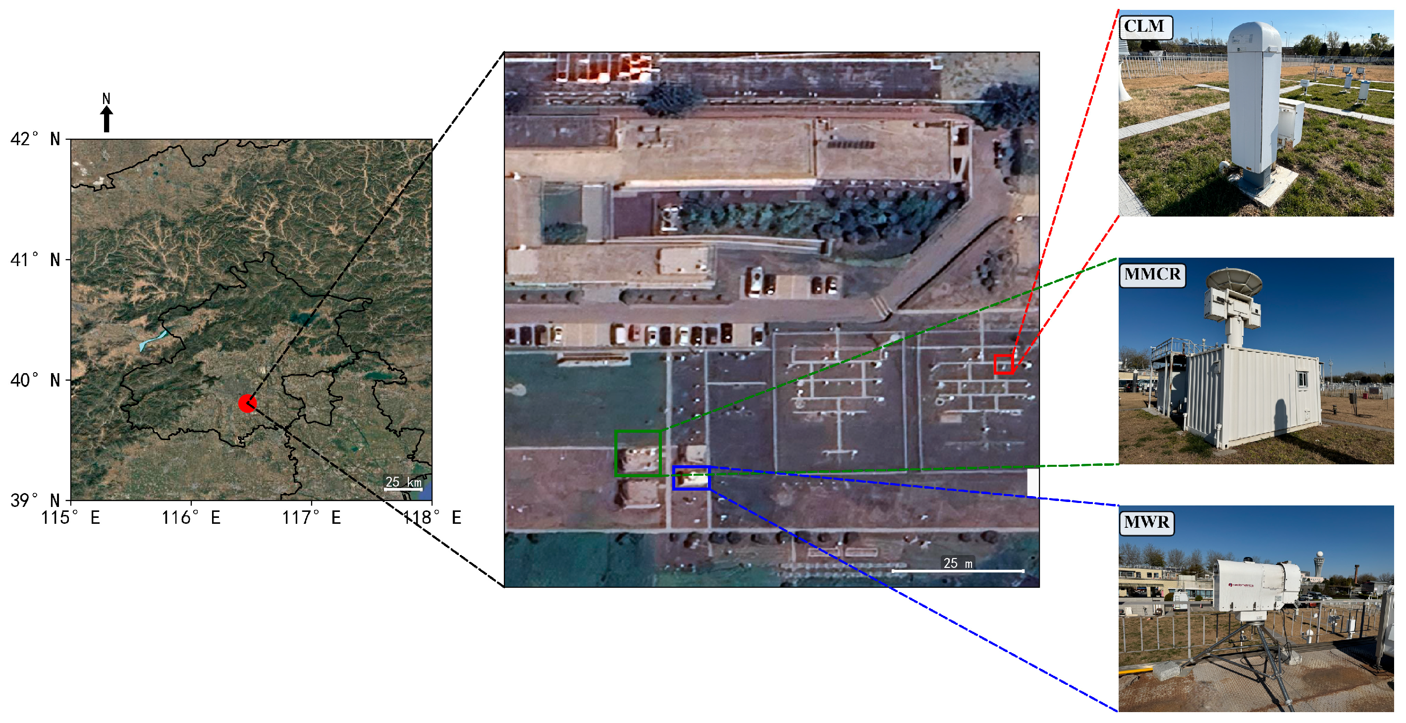
This study utilizes ground-based active and passive remote sensing observation data from the Nanjiao Observatory of the Beijing Meteorological Bureau (39.81°N, 116.47°E, elevation 32.8 m) (Figure 1). The site is located in the North China Plain and belongs to a temperate monsoon climate zone, characterized by significant seasonal variations in cloud systems, including frequent stratiform and convective cloud systems [19], making it a representative region for studying cloud microphysical properties in North China.
The data used in this study are from synchronized and collocated observations by a millimeter-wave cloud radar, microwave radiometer, laser ceilometer, and L-band radiosonde system at this site, covering the entire year of 2022 (Figure 1, middle).
The Ka-band millimeter-wave cloud radar (MMCR; 35 GHz, model HT101; Xi’an Huateng Microwave Co., Ltd. (HTMW), Xi’an, China) is an all-solid-state pulsed Doppler radar that provides Z, Vd, and Wd (Doppler velocity spectrum width) parameters. Operating in vertically pointing mode with a range resolution of 30 m, maximum detection height of 15 km, and temporal resolution of 1 min, it exhibits high detection sensitivity to cloud particles and serves as the primary data source for analyzing cloud vertical structure and retrieving microphysical quantities in this study. The minimum detectable reflectivity factor of the MMCR is −40 dBZ, with a maximum detectable reflectivity of 30 dBZ. The microwave radiometer data (MWR; RPG-HATPRO; RPG Radiometer Physics GmbH, Meckenheim, Germany; 22.2 GHz and 60 GHz) provide products including atmospheric temperature profiles and liquid water path (LWP), with a temporal resolution of 2 min. The vertical resolution is 50 m at 0–0.5 km, 100 m at 0.5–2 km, and 250 m at 2–10 km, with a maximum height of 10 km. This study utilizes the temperature profiles from its Level 2 products to assist in cloud phase determination and combines LWP to constrain the LWC retrieval process. The laser ceilometer (CLM; CL51; Vaisala Oyj, Helsinki, Finland; operating wavelength 910 nm), with a vertical resolution of approximately 5 m, temporal resolution of 1 min, and maximum detection height of approximately 15 km, identifies cloud base height derived from backscatter signals, providing important information for cloud base height determination. Additionally, this study incorporates L-band radiosonde data. The site conducts three routine radiosonde observations daily (at 08:00, 12:00, and 20:00 Beijing Time), continuously measuring meteorological parameters including atmospheric temperature, relative humidity, pressure, wind speed, and wind direction. The temperature and humidity information provided by radiosonde profiles not only ensures vertical continuity and physical consistency of the temperature field during the cloud phase identification process but can also be used to validate the reliability of cloud radar retrieval results.

2.2. Data Preprocessing and Quality Control

To ensure the consistency and reliability of multi-source observation data, this study conducted systematic spatiotemporal matching and quality control processing on millimeter-wave cloud radar, microwave radiometer, and laser ceilometer data prior to retrieval analysis. Due to differences in temporal sampling frequencies among different observation instruments, unified temporal resampling is required. This study employed the nearest-neighbor interpolation method to temporally align the original data with 1-min temporal resolution from the millimeter-wave cloud radar and laser ceilometer, along with the 2-min temporal resolution data from the microwave radiometer, to a uniform temporal resolution of 2 min. All observation instruments are deployed at the same observation site with horizontal separations less than 100 m, which are effectively collocated; thus, spatial mismatch is negligible for this analysis on cloud vertical structure analysis. To achieve vertical structure matching of multi-source data with cloud radar observations, the vertical resolution of all profile data was uniformly resampled to 30 m (i.e., the range gate length of the cloud radar). The original vertical resolution of temperature profile retrieved from the MWR varies with height (approximately 50–250 m), and linear interpolation was applied to resample them to 30 m intervals, ensuring alignment with cloud radar data on the vertical grid. Additionally, because the MWR temperature and humidity profile products extend only to approximately 10 km, while the cloud profile retrievals in this study reach up to 12 km, radiosonde observations nearest in time were incorporated in the 10–12 km layer to ensure the completeness of the temperature field.
To enhance the reliability of MWR retrieval products, quality control procedures were applied. The temperature and humidity profile products used in this study are derived from Fu et al. [20], which employs a conditional generative adversarial network to achieve high-precision atmospheric temperature profile retrieval, maintaining high accuracy under both clear-sky and cloudy conditions. Quality control for temperature data includes temporal smoothing with an 8-min filtering window to suppress high-frequency random noise and improve retrieval stability [21]. Additionally, outliers in the LWP product were removed, including positive LWP values under clear-sky conditions and extreme values exceeding 3000 g m−2 under cloudy conditions, to ensure the reasonableness of LWP retrievals.
MMCR data require noise suppression, precipitation echo identification, boundary layer clear-air clutter removal, and attenuation correction prior to use, in order to enhance the accuracy and physical consistency of cloud signals. For noise removal, first, −41 dBZ was set as the valid echo threshold, and signals below this value were considered noise and removed. Second, image morphological processing methods were introduced to perform erosion operations on the reflectivity factor field, employing rectangular convolution kernels to conduct convolution operations on neighboring grid cells to enhance the spatial continuity of echoes. Subsequently, small connected component removal was executed, where connected regions containing fewer than 30 pixels were identified as isolated noise and set to invalid values. This processing effectively improved the spatial consistency of cloud echoes. Following noise removal, precipitation echo identification and removal were conducted. When continuous echo signals appeared in 10 range gates above the radar blind zone (above 150 m), with a maximum reflectivity factor greater than −5 dBZ and a mean radial velocity less than 0, the profile was identified as a precipitation echo.
Under non-precipitating conditions, MMCR can detect clear-air echoes within the atmospheric boundary layer produced by turbulence, insects, birds, or other biological scatterers, with intensities comparable to weak cloud signals, which can easily interfere with cloud identification. Previous studies have primarily relied on cloud radar data with polarimetric observation capabilities, utilizing physical feature discrimination or spectral feature classification methods for the identification and removal of clear-air echoes [22,23]. However, the radar data used in this study lack polarimetric information such as linear depolarization ratio, making it difficult to apply the aforementioned methods. Therefore, this study adopts an empirical clear-air echo removal scheme based on joint observations from cloud radar and ceilometer. Due to the shorter operating wavelength of the laser ceilometer (910 nm), it is more sensitive to small cloud particles, and its cloud base detection results exhibit high reliability under low-cloud conditions. Signals located below the ceilometer-detected cloud base and appearing as continuous or strong echoes in the cloud radar are identified as clear-air echoes and removed. For attenuation correction, this study employs the gate-by-gate correction algorithm improved by Huang [24], which is based on the empirical relationship between radar reflectivity factor Z and attenuation coefficient k. By dividing echoes into different intervals and applying corresponding correction coefficients, attenuation correction of MMCR echoes is performed to enhance the accuracy of SLW detection and retrieval.
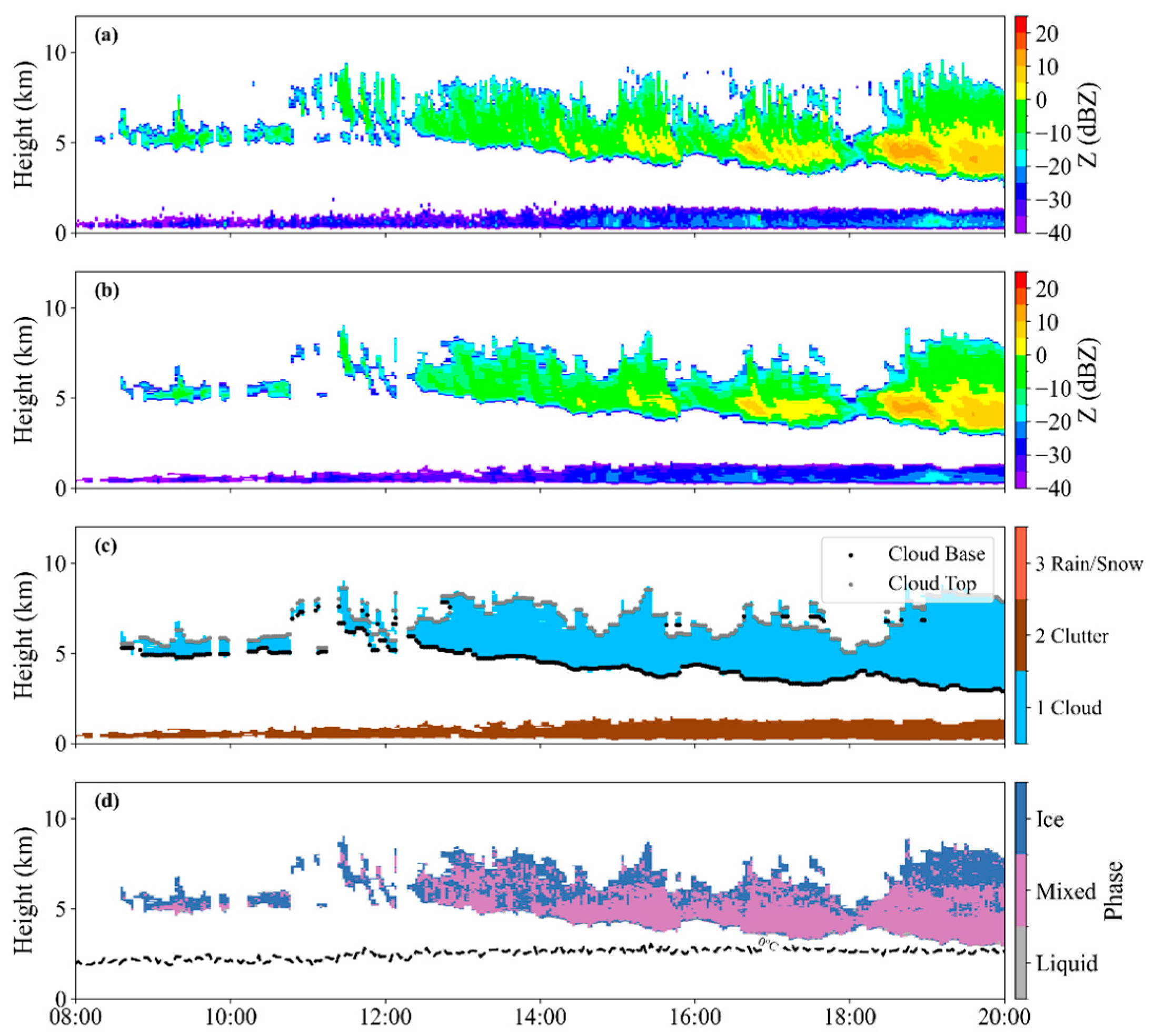
Following the aforementioned noise suppression, precipitation echo identification, and boundary layer clear-air clutter removal, cloud layer boundary identification and cloud mask construction were further conducted. The height at which the radar signal first appears is defined as the cloud base, and the height at which it last appears is defined as the cloud top. Since the laser ceilometer is more sensitive to small cloud particles and exhibits higher detection reliability, the ceilometer identification result is used as the standard for determining the first cloud layer base height at low levels. When multiple cloud layers exist in the same profile, if the height difference between the cloud top of adjacent layers and the cloud base of the upper layer exceeds 180 m, they are identified as multi-layer clouds; otherwise, they are considered a single-layer cloud. Figure 2 presents a case study of cloud radar quality control and cloud identification results from a typical event on 11 May 2022. This case demonstrates that through the complete data preprocessing procedure, the vertical structure of clouds is clearly presented, cloud boundary identification results are reasonable, and cloud signals are effectively distinguished from non-meteorological echoes, validating the feasibility and robustness of this data processing workflow.

2.3. SLW Identification and Microphysics Retrieval Method

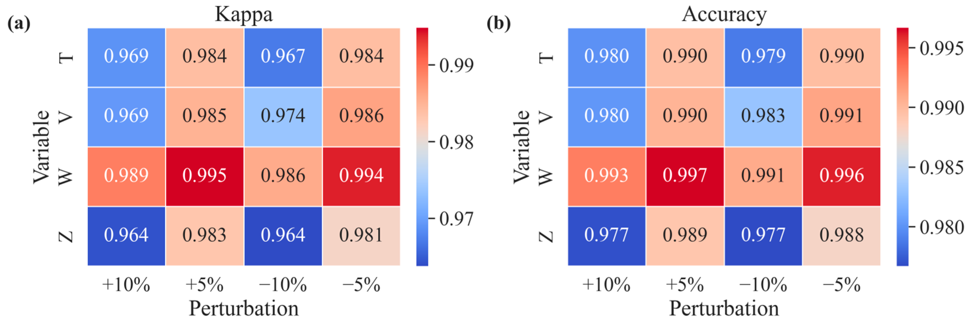
To achieve the identification of SLW in clouds and retrieve its LWC (i.e., LWCSLW), this study employs a fuzzy logic algorithm combined with the temperature observation from MWR to conduct SLW identification and microphysical parameter retrieval. Traditional phase identification methods based on single thresholds [25] are inherently rigid when dealing with continuous phase transitions, and thus fuzzy logic approaches have been widely adopted for cloud particle phase identification [26,27]. This study selects Z, Vd, Wd, and T as input variables to construct a four-dimensional parameter space for discriminating cloud particle phase. Phase identification is divided into three categories: liquid cloud droplets, ice crystals, and mixed phase (Figure 2d). For the distribution characteristics of each parameter under different phases, asymmetric trapezoidal membership functions are employed. The mathematical definition of the fuzzy logic algorithm and the form of membership functions are provided in Appendix A.1. The fuzzy logic parameters used in this study are based on previous research [28] and calibrated with local observational characteristics (Table 1). To evaluate the impact of parameter selection on phase identification results, we conducted perturbation experiments with ±10% variations in membership function boundary parameters (Appendix A.2). The results show that the overall classification consistency rates for liquid, mixed, and ice phases remain above 95%, with Kappa coefficients greater than 0.95, indicating that the classification results are insensitive to minor parameter variations. Additionally, since the algorithm integrates multiple independent parameters including reflectivity factor, Doppler velocity, spectrum width, and temperature, uncertainties from individual parameters are effectively suppressed, further enhancing the robustness of identification.
The identification of SLW is defined as follows: when a height level is identified as liquid cloud or mixed-phase cloud and the ambient temperature is below 0 °C, that layer is classified as SLW. For mixed-phase conditions, the relative contribution proportions of liquid water and ice phase are further calculated, using temperature as the distinguishing criterion. In specific processing, the liquid water fraction (Liq_fraction) is defined as the contribution proportion of liquid water to the radar reflectivity factor in mixed phase, and the ice phase fraction (Ice_fraction) is defined as the contribution proportion of ice particles to the radar reflectivity factor.
L i q _ f r a c t i o n = ( T + 40 ) / 40
I c e _ f r a c t i o n = 1 L i q _ f r a c t i o n
where T is the temperature in °C, with the value range −40 °C < T < 0 °C.
Based on the identification of liquid or mixed-phase clouds, the Supercooled liquid water content (LWCSLW) is further retrieved. An empirical relationship exists between radar reflectivity factor Z and LWC [29]:
L W C = N 0 Z l i q u i d 3.6 1 / 1.8
Z l i q u i d = L i q _ f r a c t i o n × Z
where Zliquid is the contribution of the liquid portion to the reflectivity factor at the current layer, and N0 represents the cloud droplet number concentration constant (units: cm−3), set to 100 cm−3 [29]. Additionally, to enhance the physical consistency of retrieval results, the LWP retrieved from the MWR is introduced as an independent constraint. The MWR LWP value is taken as the average of non-zero brightness temperature retrieval results within six minutes closest to the cloud radar observation time. The integrated value obtained by vertically integrating the retrieved LWC profile should be close to the MWR-observed LWP. The vertically integrated LWP from the retrieved LWC profile should be comparable to the MWR-observed LWP value. However, due to factors such as assumptions about cloud droplet number concentration N0 or differences in representativeness of cloud vertical structure, the integrated LWP (denoted as LWPretrieved) may exhibit systematic bias from the MWR-observed LWP (denoted as LWPMWR). Therefore, following the scaling algorithm adopted in the MICROBASE cloud product of the U.S. ARM program [21], a linear proportional correction is applied to the originally retrieved LWC profile.
L W C a d j ( z ) = L W C ( z ) × L W P M W R L W P r e t r i e v e d
where L W P r e t r i e v e d = 0 H L W C z d z , and the integration height H is the cloud top height. This adjustment ensures that the finally retrieved LWC profile is consistent with the independently observed LWP in the sense of vertical integration, enhancing the reliability and energy closure of the retrieval product.

3. Results

3.1. Comparison of Cloud Identification Methods

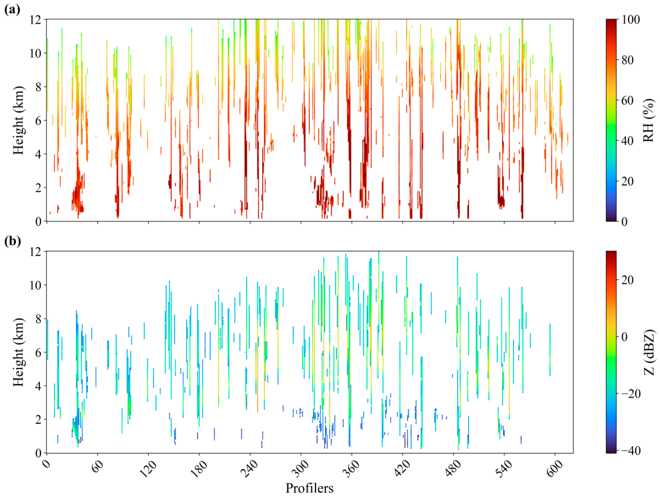
To evaluate the performance of the cloud radar in identifying cloud boundaries, Figure 3 compares the cloud boundary detection results obtained from the MMCR with those derived from radiosonde observations. The radiosonde cloud boundaries are identified using the improved relative-humidity-based algorithm proposed by Zhang et al. [30], which simultaneously considers cloud-base height, cloud thickness, vertical continuity, and humidity characteristics. This method effectively filters out false moist layers and has been widely applied to multilayer cloud structure detection. For comparison, the cloud radar data are temporally averaged over each radiosonde launch period to match the sampling window during the balloon ascent. Overall, cloud boundaries identified by the radar show good consistency with those detected by radiosondes for low-level and mid-level cloud structures, and the radar can reliably capture the major cloud layers. However, discrepancies remain at finer scales. In particular, above 8 km, cloud layers are detected considerably more frequently by radiosondes than by the radar, by approximately 15.6%.
These differences primarily stem from two factors. First, radiosondes provide high-vertical-resolution humidity measurements and are more sensitive to weak or optically thin ice clouds, whereas cloud radar relies on backscattered signals and may miss such layers when particle concentrations are low and reflectivity falls below the detection threshold. Second, spatial representativeness differs between the two instruments, which radiosondes drift horizontally with the wind during ascent, causing their sampling paths to deviate from the fixed-beam location of the radar, which can result in localized discrepancies in the observed cloud structures.

3.2. Seasonal and Diurnal Characteristics of Cloud Occurrence

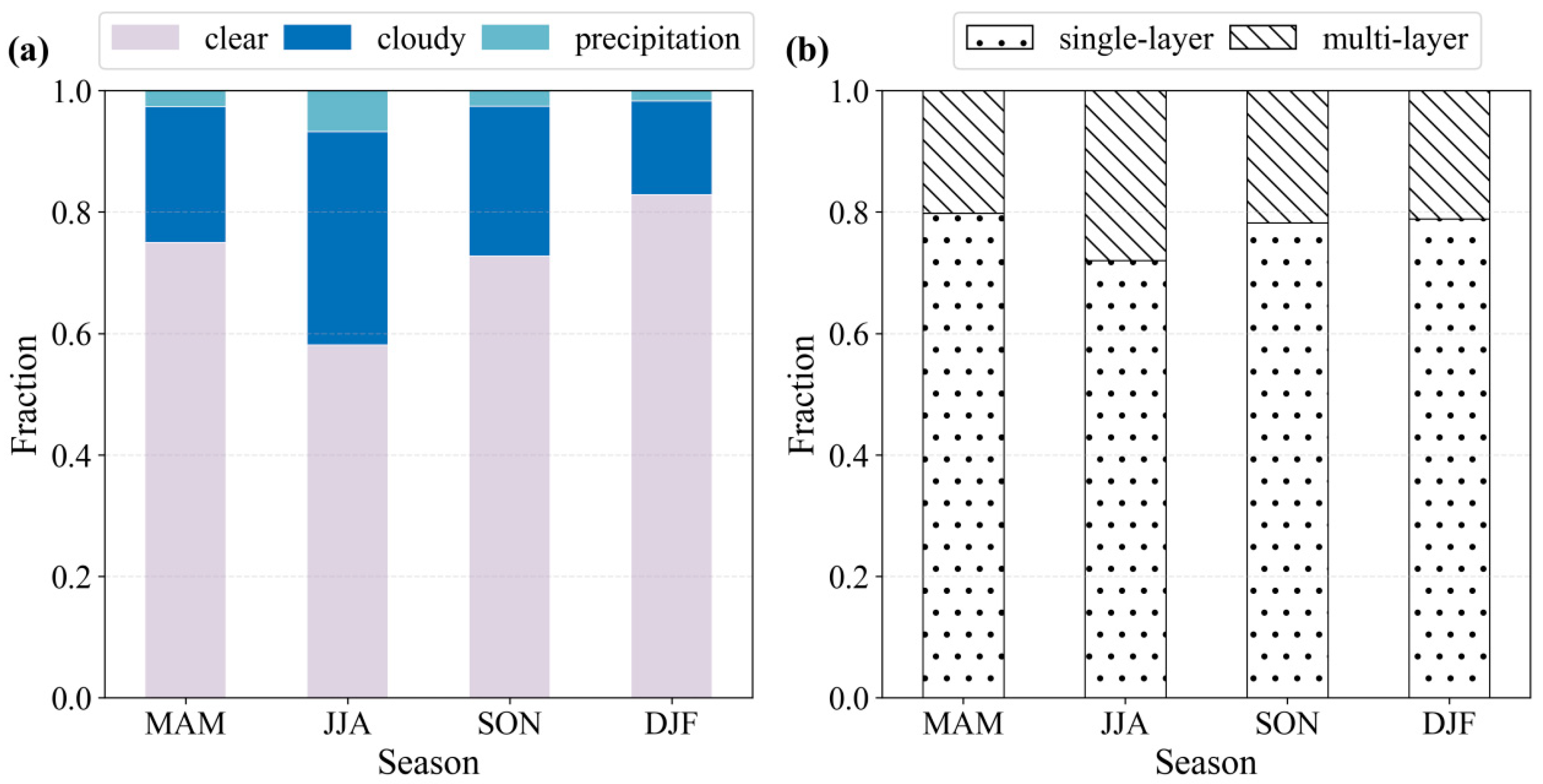
Figure 4 presents seasonal statistics of cloud occurrence over North China Plain in 2022, following the cloud classification method outlined in Section 2.2, each vertical profile was categorized into one of three mutually exclusive conditions: clear sky, non-precipitating clouds (hereafter referred to as “cloudy”), and precipitation clouds (referred to as precipitation). As shown in Figure 4a, the relative frequencies of these three conditions exhibit pronounced seasonal variability. Clear-sky conditions dominate during winter (DJF), spring (MAM), and autumn (SON), whereas their proportion drops significantly in summer (JJA). Conversely, the frequency of cloudy conditions peaks in summer at approximately 25%, coinciding with the highest occurrence of precipitation (~10%), which is largely confined to this season. This summertime enhancement in cloudiness is closely linked to increased moisture transport associated with the East Asian summer monsoon. In contrast, winter features the lowest overall cloud amount and is characterized predominantly by non-precipitating, single-layer clouds. Figure 4b further breaks down the cloud layer structure under cloudy conditions. Single-layer clouds prevail throughout the year, accounting for more than 75% of all cloudy profiles. Multi-layer clouds, though less frequent overall, show a marked increase during summer, suggesting more complex vertical cloud structures in this season—likely driven by frequent deep convection and enhanced atmospheric instability. In winter, cloud systems are comparatively simple and almost exclusively single-layered.
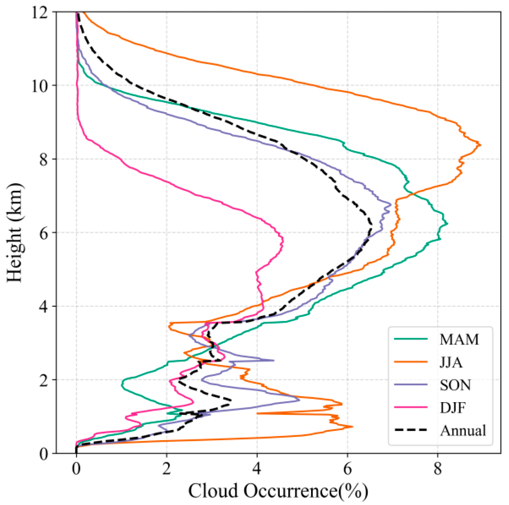
Figure 5 shows the vertical distribution of cloud occurrence frequency and its seasonal variation characteristics. Cloud occurrence frequency is defined as the ratio of the number of moments with clouds at that height level to the total number of observation moments. The annual mean profile exhibits a bimodal structure: a lower peak near 1.5 km (cloud frequency ≈ 3.4%), associated with boundary-layer clouds, and a more prominent upper peak around 6 km (frequency ≈ 6.5%), corresponding primarily to mid-level clouds. In terms of seasonal differences, spring, summer, and autumn all exhibit distinct bimodal distribution characteristics. In contrast, winter shows significantly reduced cloud frequency without obvious low cloud signals. This is primarily attributable to weak solar radiation and insufficient surface heating in winter, resulting in limited boundary layer development and difficulty in triggering local convection or forming stable low-level stratiform clouds. Additionally, the generally drier conditions in winter—characterized by lower atmospheric moisture content—further suppress cloud formation in the lower troposphere. Meanwhile, at higher altitudes, colder temperatures more readily reach ice saturation, favoring the formation of elevated ice clouds. Notably, the upper cloud frequency peak shifts upward dramatically in summer, reaching approximately 9 km—significantly higher than in other seasons. This elevation reflects the frequent development of deep convective systems (e.g., cumulonimbus clouds) fueled by strong thermal forcing, abundant moisture, and dynamic lifting during the monsoon season.
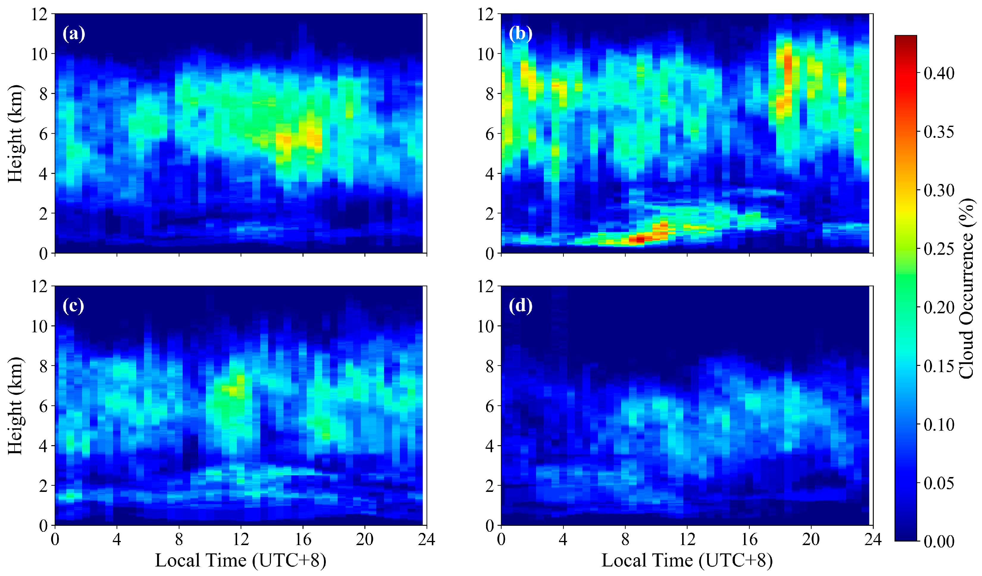
Figure 6 shows the diurnal cycle of cloud occurrence frequency for different seasons, revealing distinct diurnal patterns across altitude ranges. Low-level clouds (below 2 km) are tightly coupled to boundary-layer evolution, peaking between 08:00 and 17:00 local time, with cloud-top heights rising through the day in response to surface heating—indicating that their formation is primarily driven by daytime thermodynamic processes. In contrast, clouds in spring occur predominantly at mid-to-upper levels during the daytime, with little presence near the surface. Autumn and winter show no pronounced diurnal variation in cloud occurrence. The pattern of mid- to high-level clouds is most pronounced in summer as well, aligning with findings from Chen et al. [31], who link afternoon convection to orographic heating over the northwestern mountains and nocturnal convection to processes over the southeastern plains—underscoring strong regional and diurnal heterogeneity in convective triggering mechanisms.

3.3. Vertical Distribution of SLW: Seasonal and Diurnal Variability

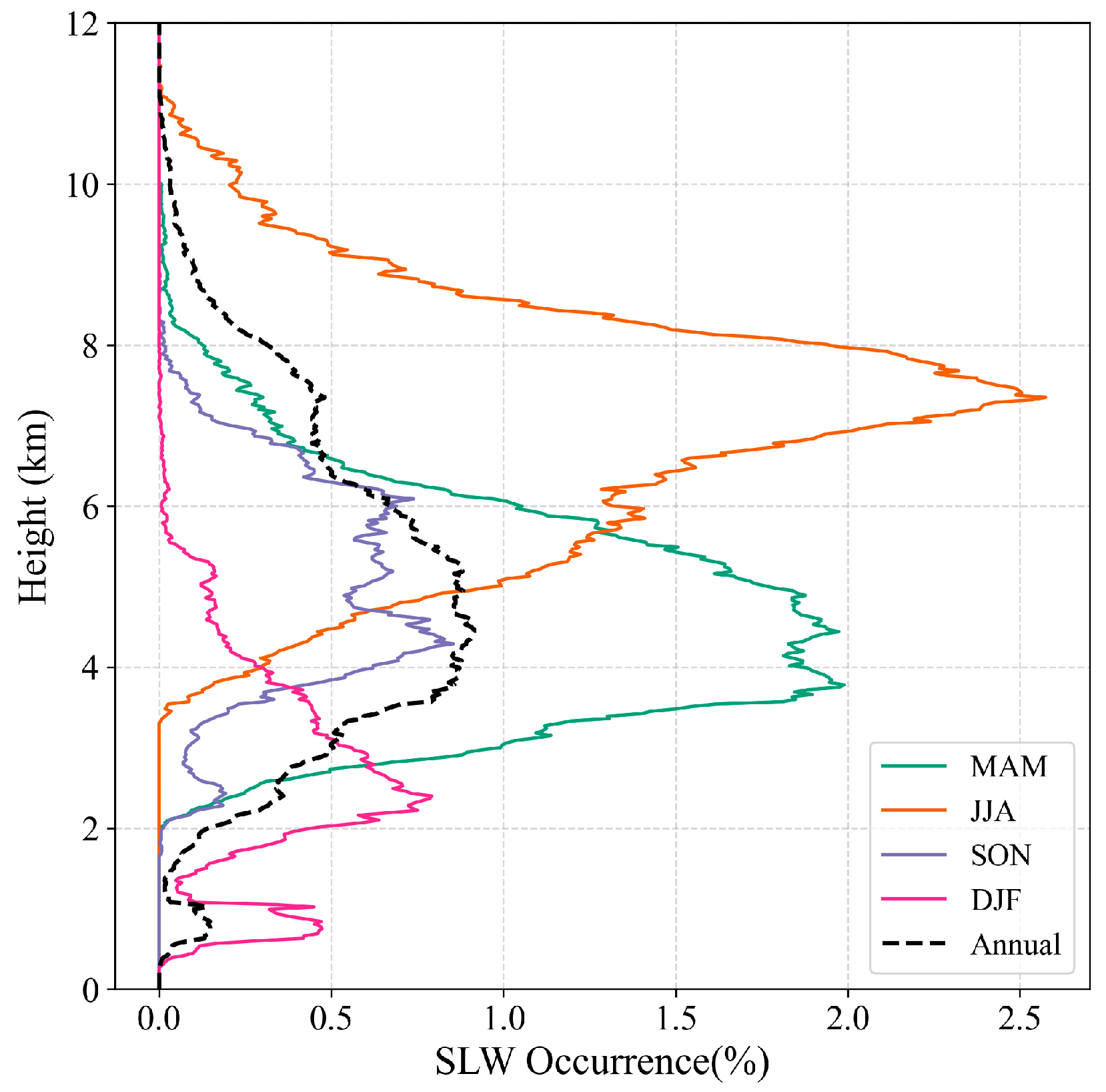
Leveraging the precise cloud boundary detection from cloud radar, cloud phase classification was further applied to investigate the macro- and microphysical properties of SLW and its spatiotemporal distribution. Figure 7 shows the vertical profile and seasonal variation in SLW occurrence frequency over North China in 2022. Overall, SLW exhibits a distinct bimodal vertical structure with strong seasonal dependence: one peak occurs in the mid- to upper troposphere (4–6 km), with a maximum frequency of approximately 1%, while the other is confined to the lower troposphere (below 2 km) and is almost exclusively observed during winter. Mid- and upper-level SLW is predominantly associated with spring and summer, with summer showing the highest occurrence near 7.5 km. The occurrence of mid- and upper-level SLW is closely associated with intense deep convection [32]. During spring and summer, frequent cumulus activity combined with low-pressure systems and strong updrafts transports a large number of liquid droplets above the freezing level. Due to insufficient ice nuclei or short residence times, these droplets do not freeze, resulting in mixed-phase cloud tops rich in SLW. In contrast, low-level SLW is almost absent outside winter and peaks at 1–2 km during winter. This is because winter is characterized by fewer low-pressure systems and a more stable environment, leading primarily to shallow, stable supercooled liquid water clouds [11]. The near absence of low-level SLW in non-winter seasons is mainly due to relatively high temperatures in the lower troposphere, which prevent droplets from remaining supercooled.
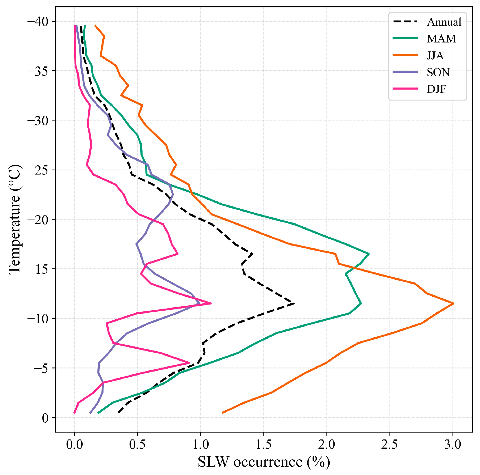
Figure 8 presents the temperature-dependent occurrence probability of SLW clouds. The occurrence probability of SLW clouds reaches its maximum at −12 °C, which is the sub-zero temperatures are key for SLW cloud formation over the North China Plain. Seasonally, spring displays a secondary peak at −16 °C in addition to relatively high occurrence at −12 °C. Summer is dominated by the −12 °C peak, while autumn exhibits peaks at −12 °C and a smaller one at −23 °C. In winter, a small peak appears at −6 °C, with additional contributions at −12 °C and −16 °C. These results indicate that, although the annual maximum occurs at −12 °C, the secondary peaks reflect distinct seasonal contributions, highlighting the temperature-dependent seasonal variability of SLW occurrence across North China Plain.
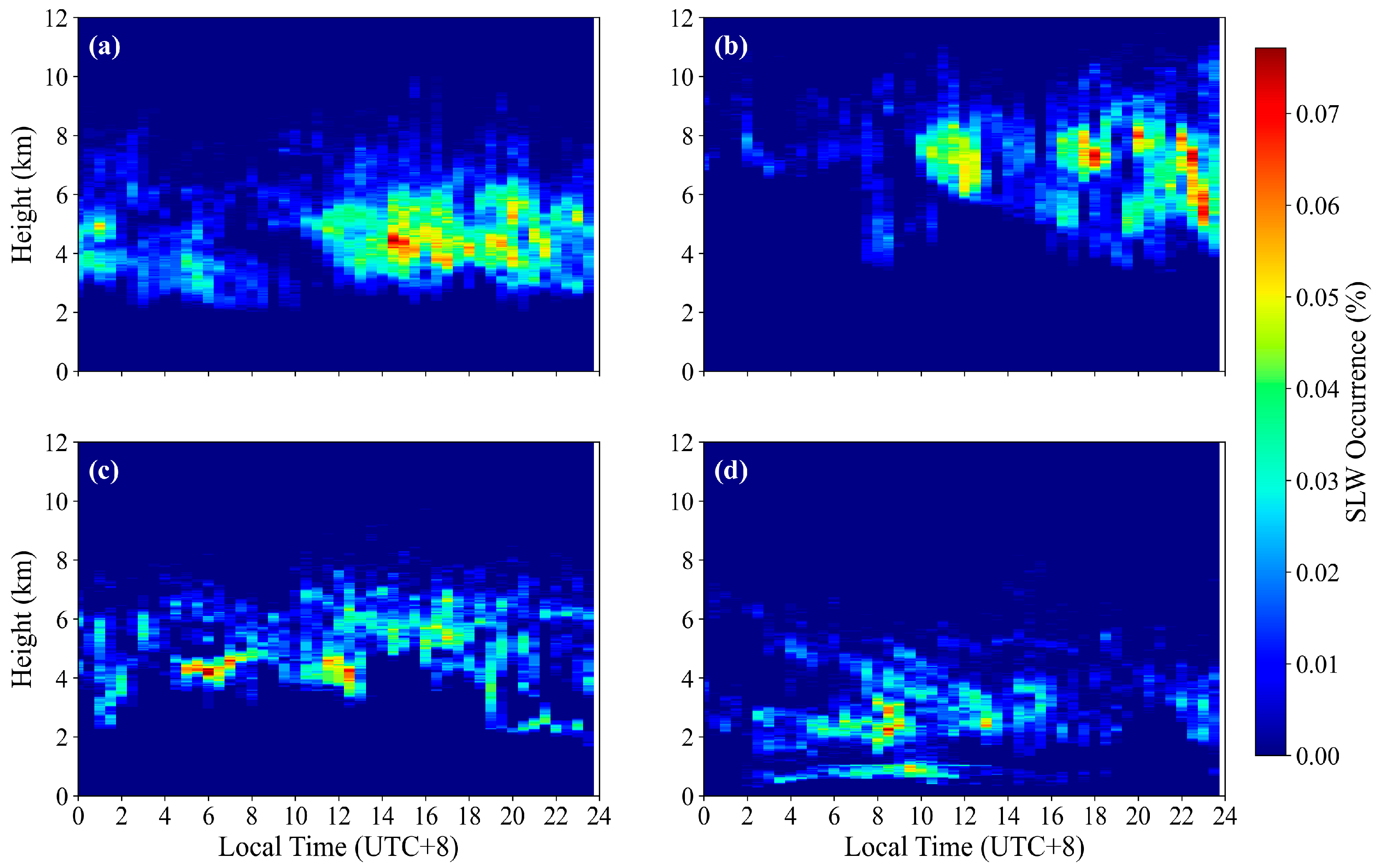
Figure 9 illustrates the diurnal cycle of SLW occurrence frequency, averaged at 30-min intervals. In spring, SLW primarily occurs in the mid-to-upper troposphere (4–8 km) during daytime, with minimal low-level occurrence. Summer exhibits the most active SLW activity, showing a bimodal diurnal cycle: one peak in the afternoon (12:00–18:00) and a secondary nighttime peak (20:00–02:00), likely associated with nocturnal convection. Autumn displays moderate and relatively uniform SLW occurrence throughout the day, mainly below 6 km. In winter, SLW is confined to lower altitudes (1–3 km), with a weak diurnal signal, reflecting stable atmospheric conditions and limited vertical mixing. Overall, SLW occurrence is strongly modulated by seasonally varying thermodynamic and dynamic processes, with the highest frequency and vertical extent observed in summer.

3.4. Vertical Distribution of SLW Microphysical Properties

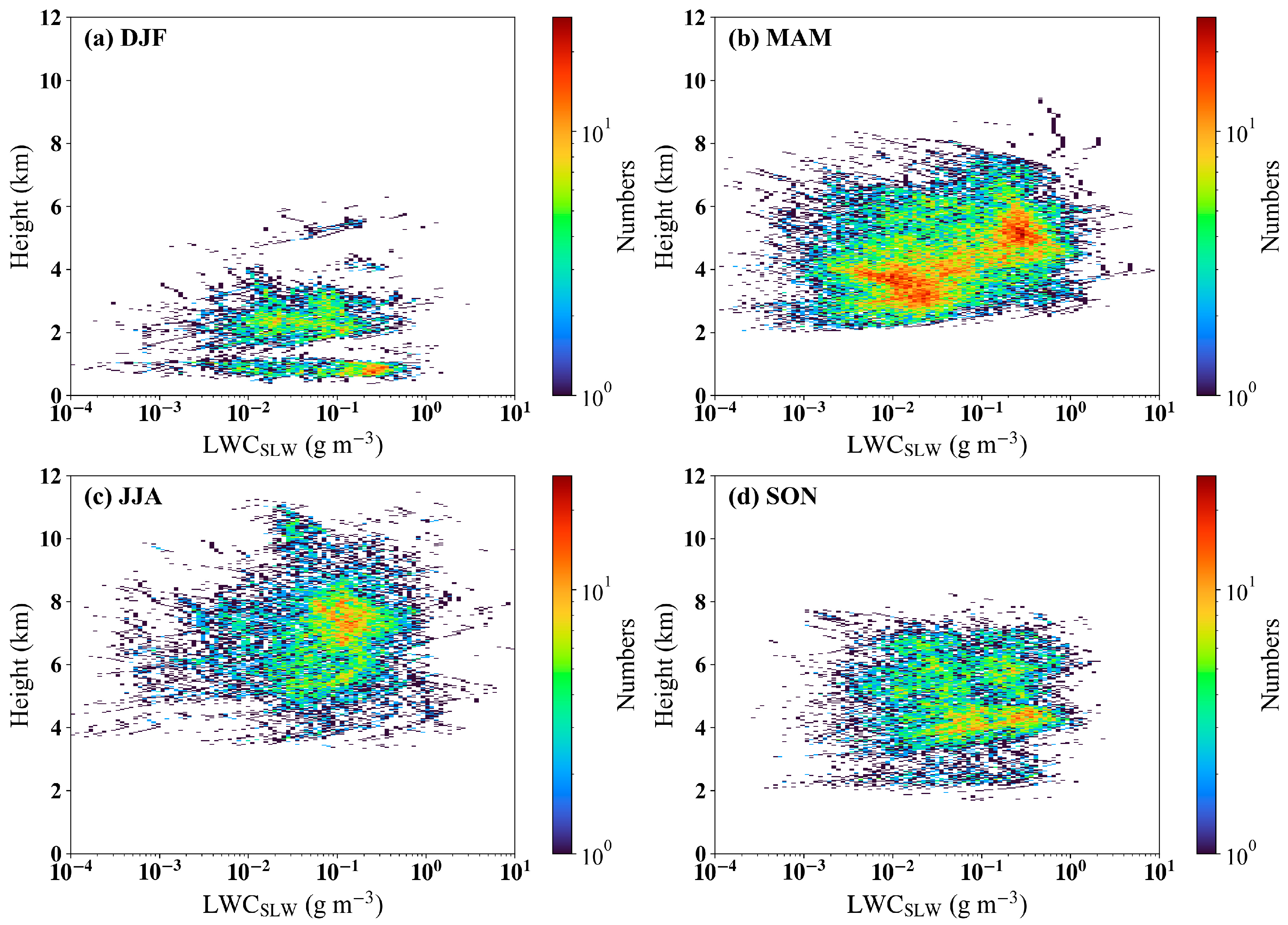
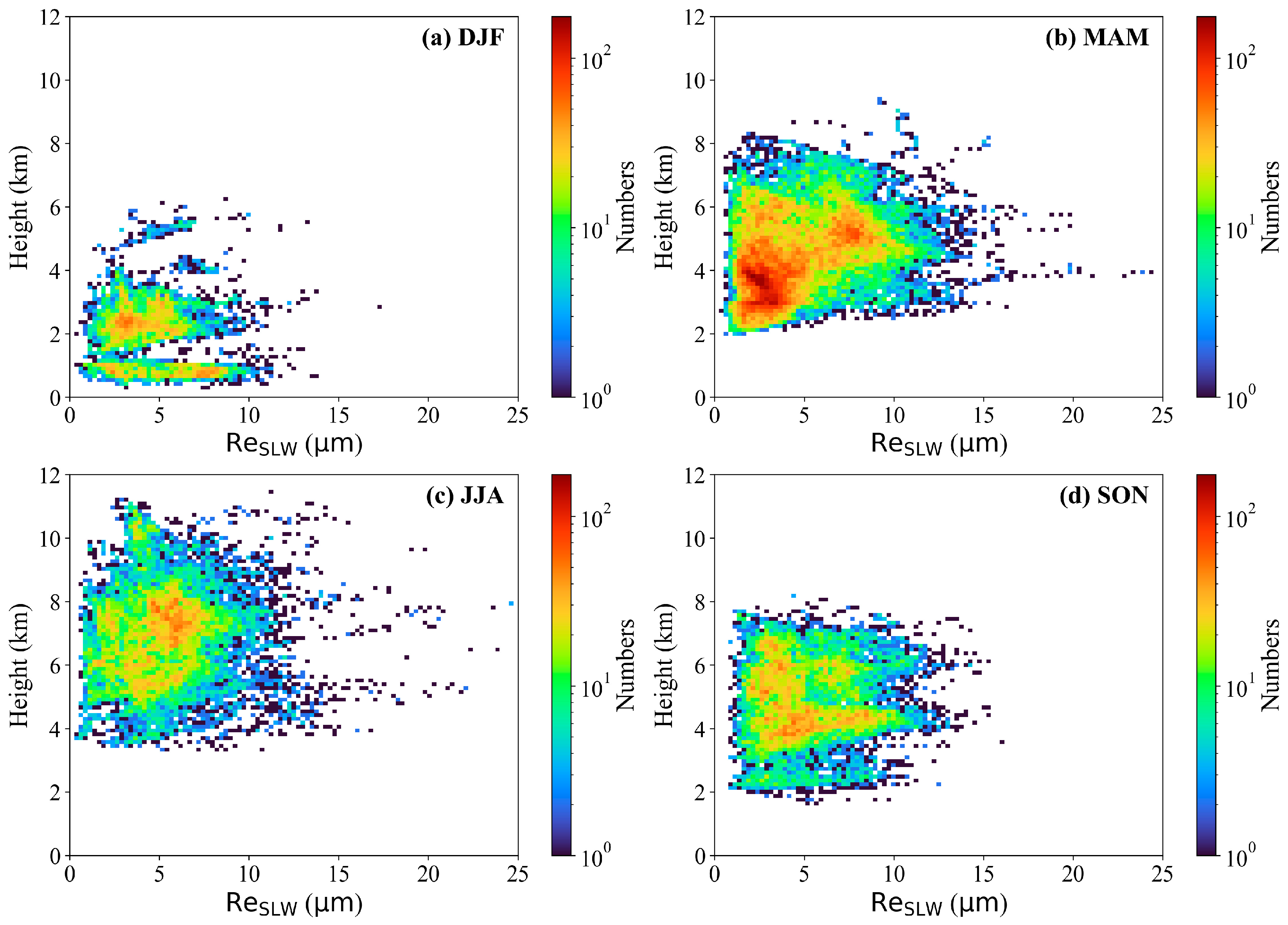
Figure 10 and Figure 11 present the seasonal characteristics of the vertical distribution of SLW microphysical properties—specifically LWCSLW and Re. In spring, summer, and autumn, a dominant concentration zone of SLW is observed with Re ranging from 5 to 10 μm and LWCSLW between 0.1 and 1.0 g m−3. This regime likely corresponds to cloud layers characterized by relatively high moisture availability and active condensational growth, possibly under conditions favorable for convective development. Additionally, spring and autumn exhibit a secondary mode with smaller droplets (Re < 5 μm) and lower LWCSLW (0.01–0.1 g m−3), which may be associated with more quiescent, stable cloud environments. In contrast, winter SLW is confined to the lower troposphere (0–2 km), with LWCSLW generally low (0.1–0.2 g m−3) but Re relatively large (6–8 μm). This suggests that under cold, stable atmospheric conditions—with weak turbulence, persistent radiative cooling, and limited ice nucleation—supercooled droplets can persist below 0 °C and undergo prolonged condensational growth, leading to fewer but larger droplets despite modest total LWC.
Notably, the retrieved ranges of LWCSLW and Re show good agreement with aircraft in situ measurements of SLW in cumulus and stratus clouds over North China reported in the literature (see Table 2). The consistency in parameter ranges—higher LWCSLW and larger droplets in more dynamic conditions versus lower LWCSLW and smaller droplets in stable regimes—supports the physical plausibility of the observed microphysical patterns. This agreement further validates the reliability of the combined MMCR–MWR retrieval approach for characterizing SLW microphysics from ground-based remote sensing.

4. Conclusions and Perspectives

Based on the all-year round comprehensive analysis of synergistic ground-based observations in Beijing, this study develops an integrated retrieval framework to identify supercooled liquid water (SLW) layers and quantify their microphysical properties. The main conclusions are summarized as follows.
Our integrated retrieval framework includes cloud boundary detection and SLW retrieval algorithm. The cloud detection algorithm shows good consistency with radiosonde observations. Retrieved microphysical properties of SLW agree well with aircraft in situ measurements reported in the literature, demonstrating the robustness of the combined MMCR–MWR retrieval framework.
Cloud occurrence exhibits strong seasonal and diurnal variability, with the highest frequency in summer and the lowest in winter. Low-level clouds predominantly occur during daytime, closely linked to boundary layer development, while mid- and high-level clouds show a bimodal diurnal pattern influenced by terrain-induced afternoon convection and nocturnal convective activity.
The vertical distribution of SLW is distinctly bimodal and seasonally dependent. A mid- to upper-level maximum (4–7.5 km) prevails in spring and summer, a pattern particularly pronounced near 7.5 km in summer. This reflects the role of deep convective updrafts in transporting liquid droplets above the freezing level, thereby forming mixed-phase cloud tops rich in SLW. In contrast, low-level SLW (1–2 km) occurs almost exclusively in winter, where it is associated with shallow, stable stratiform clouds under subfreezing conditions. The temperature-dependent occurrence probability of SLW clouds has an annual maximum at −12 °C. SLW shows strong seasonal and diurnal variability: dominant in mid-upper levels during spring/summer days, with a secondary night peak in summer; confined to low levels in winter under stable conditions; and weakly variable in autumn.
During spring, summer, and autumn, SLW is characterized by effective radii of 5–10 μm and LWCSLW of 0.1–1.0 g m−3, with a secondary mode of smaller droplets and lower LWC. In winter, SLW exhibits relatively larger droplets (6–8 μm) despite lower LWC (0.1–0.2 g m−3), consistent with slow condensational growth under cold, stable conditions.
To our knowledge, this work presents the first ground-based vertically resolved SLW based on synergy of multiple observations over North China Plain. This dataset fills a critical observational gap regarding mixed-phase clouds in mid-latitude continental regions and provides a robust benchmark for evaluating cloud microphysics parameterizations in numerical models [34]. Our findings offer immediate practical value for guiding operational weather modification. The precise seasonal and diurnal characterizations of SLW vertical distribution, liquid water content, and droplet effective radius provide critical insights for optimizing key operational decisions, including seeding catalyst type, altitude selection, and timing, thereby enhancing the efficiency of artificial precipitation enhancement in this water-stressed region.
Despite these contributions, this study also has some limitations: drizzle or light precipitation contamination was not identified or removed, which may lead to slight biases in low-level LWC.
Building directly on the specific processes revealed in this study, we propose three promising directions for future work:
The algorithm and insights gained here will be applied to a distributed observation network across North China. This will not only help construct a spatially resolved SLW climatology but also allow us to investigate how regional topography and aerosol backgrounds influence the SLW distribution patterns we have identified, particularly the winter low-level and summer deep-convective modes.
To disentangle the physical mechanisms behind the distinct SLW vertical structures, we will integrate our observations with high-resolution WRF model simulations. Controlled sensitivity experiments will be designed to quantitatively assess the relative contributions of dynamical lifting (as implicated in the summer convective peaks) versus ambient thermodynamic conditions (critical for the shallow winter layers) in sustaining SLW.
The observed microphysical properties, especially the secondary mode of small droplets and the seasonally varying effective radius, suggest potential influences from ice-nucleating particles (INPs) and background aerosols. Future work will incorporate co-located aerosol and INP observations to preliminarily investigate how INP concentrations modulate SLW depletion rates and phase transition efficiency, a key uncertainty in climate prediction.
Author Contributions

Conceptualization, H.S. and X.X.; methodology, H.S., Y.B. and J.X.; python 3.8 software, Y.L.; validation, Y.L., J.Z. and X.F.; formal analysis, H.S. and Y.L.; investigation, Y.L. and Q.L.; resources, F.T., S.H., Y.X. and D.F.; data curation, F.T. and P.T.; writing—original draft preparation, Y.L. and H.S.; writing—review and editing, X.X. and H.S.; visualization, P.T. and X.Z.; supervision, J.S. and Z.Y.; project administration, H.C.; funding acquisition, H.S. and J.Y. All authors have read and agreed to the published version of the manuscript.

Funding

This research was funded by the Strategic Priority Research Program of the Chinese Academy of Sciences, grant number XDB0760402; the National Natural Science Foundation of China, grant number 42275091, 42575211, 42205124; the State Key Laboratory of Atmospheric Environment and Extreme Meteorology, grant number 2024QN06; and Sichuan Science and Technology Program No. 2024NSFTD0044.

Data Availability Statement

The raw data supporting the conclusions of this article are available from the corresponding author upon reasonable request. The raw data are available from the corresponding author upon reasonable request.

Acknowledgments

We would like to thank the Beijing Meteorological Bureau for providing the observational data.

Conflicts of Interest

The authors declare no conflicts of interest.

Appendix A

Appendix A.1. Fuzzy Logic Membership Functions

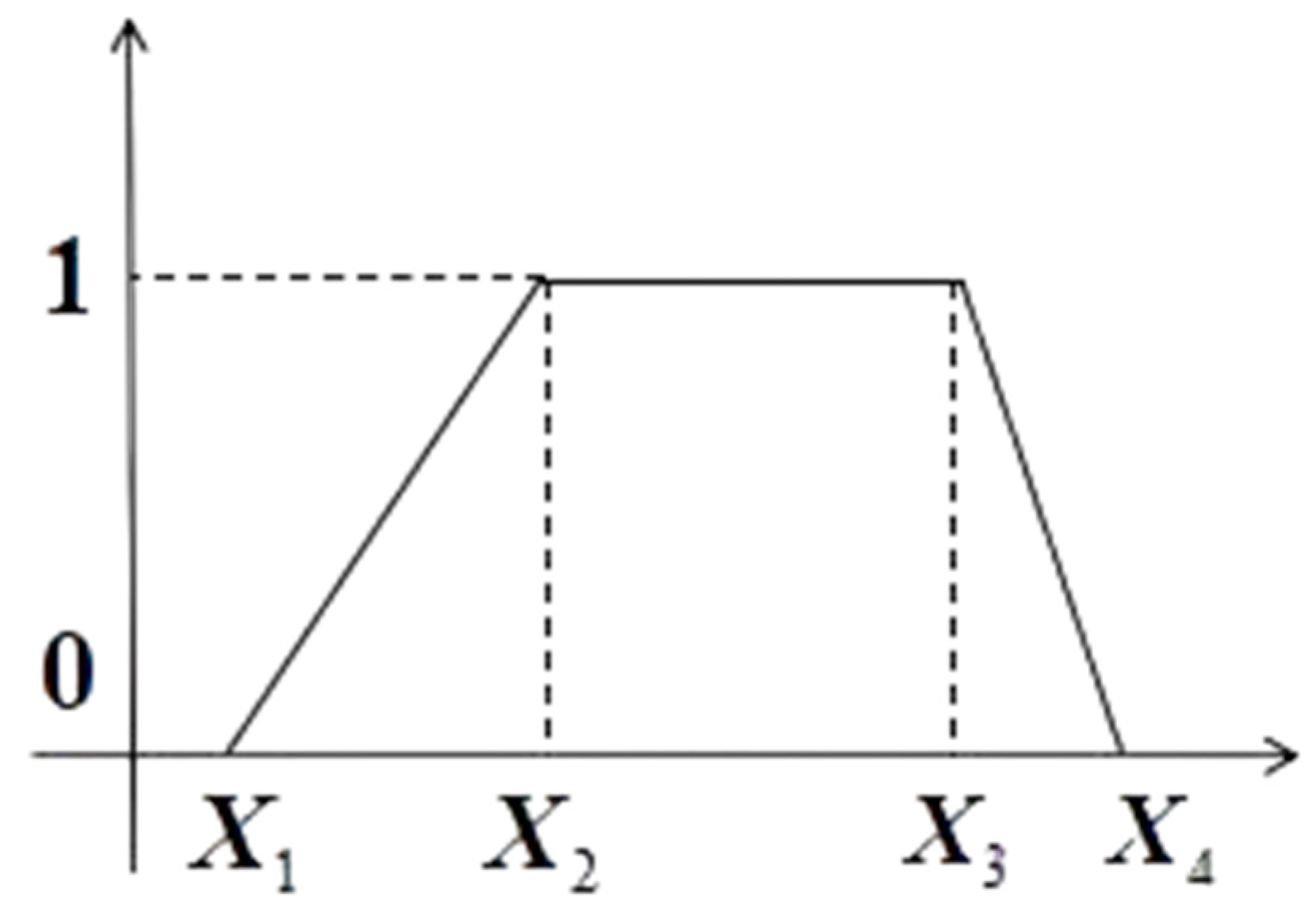
Fuzzy logic algorithm is a logic algorithm based on fuzzy set theory, which is essentially a new method combining fuzzy set theory and automated processing techniques. Based on statistical experience, fuzzy logic is summarized into a set of qualitative descriptive conditional statements, which serve as transition transformation functions. Then, fuzzy sets are utilized to combine and quantify different conditional statements. This demonstrates that the fuzzy logic algorithm possesses strong extensibility and compatibility, and can effectively improve the identification of hydrometeor phase states using strictly linearized threshold methods. Its principle is to use relevant influencing factors (such as Z, V_d, W_d, T) as input parameter matrices, and through established transformation relationships, namely transformation functions, quantify the input parameter matrices. Then, through certain aggregation rules, they are ultimately converted into hydrometeor phase state matrices. Based on the above five parameters, asymmetric trapezoidal functions with simple morphology are adopted as transformation functions, also called membership functions, to fuzzify different hydrometeor phase states. The cloud particle phase categories identified in this study include liquid cloud droplets, mixed phase, and ice crystals, totaling three types. The shape of the trapezoidal function is determined by four parameters, and the membership function expression is given in Equation (A1). It should be noted that setting the segmentation parameters for different hydrometeor phase states in this identification algorithm is crucial.
P ( x , X 1 , X 2 , X 3 , X 4 ) = 0 , x < X 1 x X 1 X 2 X 1 , X 1 x < X 2 1 , X 2 x < X 3 X 4 x X 2 X 3 , X 3 x < X 4 0 , X 4 x
where P represents the membership degree, and x represents the measured radar parameters and temperature. When x falls into different interval ranges, it has different membership degrees.
Figure A1. Form of asymmetric trapezoidal membership function.
Remotesensing 18 00160 g0a1
Next, i represent the cloud particle phase categories that can be identified, totaling 3, and j represent the influencing factors considered for identifying hydrometeor phase states, totaling 4. Therefore, the total membership degree of all influencing factors to the i-th category of particles can be expressed as:
S i = j = 1 4 A j P i j

Appendix A.2. Sensitivity Experiments of Membership Parameters

This experiment aims to analyze the sensitivity of fuzzy logic model output to changes in membership function parameters (Z, V, W, T) and test the robustness of the model to parameter settings. The experiment employs a single-factor sensitivity analysis method, changing only one parameter at a time while keeping other parameters constant. Perturbations of +10%, +5%, −10%, and −5% are applied, respectively, based on the baseline values. The Kappa coefficient is used to measure classification consistency, and Accuracy is used to measure overall precision. The sensitivity analysis results are shown in Figure A2:
Figure A2. Sensitivity analysis heatmaps of membership function parameter perturbations. (a) Kappa coefficient; (b) Accuracy.
Remotesensing 18 00160 g0a2
Under all perturbation scenarios, Kappa values remain between 0.960 and 0.990, indicating strong model stability. Accuracy fluctuates between 0.980 and 1.000, demonstrating overall excellent performance. These results validate the model’s robust tolerance to parameter perturbations. Even when parameters deviate from optimal values by ±10%, performance degradation remains below 2%, ensuring the model’s robustness in practical applications.

Appendix A.3. Uncertainty Analysis of SLW Microphysical Retrievals

The uncertainty in retrieving microphysical parameters of SLW mainly arises from instrumental measurement errors, phase classification errors, and the parameterization assumptions used in the retrieval process. Among these, the uncertainty associated with phase classification has been systematically evaluated through sensitivity experiments in Appendix A.2. The results indicate that the fuzzy logic phase classification is highly stable against input perturbations (Kappa coefficients > 0.96) and has a limited effect on the retrieval results.
Building on this, this part further evaluates the uncertainty in SLW microphysical retrievals associated with the Liq_fraction. Following the MICROBASE approach, which originally used −16 °C as the temperature threshold for Liq_fraction. Observations have shown that supercooled liquid water can exist over a wide temperature range from −40 °C to 0 °C [35,36], and similar features are observed over North China [11]. Accordingly, we extended the temperature threshold range to span from 0 °C to −40 °C in our scheme. To further assess the impact of this parameterization adjustment, we have conducted a sensitivity analysis by perturbing the temperature threshold parameter (−20, −25, −30, −35, and −40 °C) and re-computing the microphysical properties. Sensitivity tests indicate that the choice of the temperature threshold has a significant impact on the retrieval results. Within the tested threshold range (−20 °C to −40 °C), the relative variation in the annual mean LWC is approximately 16.3%, and that in the effective radius (Re) is about 6.3%.
Additionally, perturbation experiments were conducted for the assumed droplet concentration N0 (100, 125, 175, 200, 250 cm−3). The results show that N0 variations introduce an annual mean Re uncertainty of about 23.3%, while the effect on LWC is negligible (~0.01%), which may be due to the LWP constraint applied in the retrieval.
It should be noted that the uncertainties discussed above primarily reflect the sensitivity to parameterization choices, namely the temperature-dependent reflectivity assumption and N0 perturbations. In practice, instrumental measurement errors also propagate into the SLW microphysical retrievals. The ground-based cloud radar used in this study has a reflectivity measurement accuracy of approximately 0.5 dBZ, and the uncertainty in LWP retrieved from the microwave radiometer is about 20–30 g m−2 [37].

References

  1. Li, J.; Lv, Q.; Zhang, M.; Wang, T.; Kawamoto, K.; Chen, S.; Zhang, B. Effects of atmospheric dynamics and aerosols on the fraction of supercooled water clouds. Atmos. Chem. Phys. 2017, 17, 1847–1863. [Google Scholar] [CrossRef]
  2. Cao, Y.; Tan, W.; Wu, Z. Aircraft icing: An ongoing threat to aviation safety. Aerosp. Sci. Technol. 2018, 75, 353–385. [Google Scholar] [CrossRef]
  3. Xiao, M.; Fu, D.; Shi, H.; Wang, G.; Lei, H.; Han, X.; Xia, X. Evaluating and Enhancing Fengyun AGRI Cloud Detection with the Ensemble Learning Algorithm. Adv. Atmos. Sci. 2025, 42, 981–993. [Google Scholar] [CrossRef]
  4. Roskovensky, J.K.; Ivey, I.; Porch, W.; Beavis, N.; Hermann, R.; Silber, S. Cloud super-cooled liquid water estimation from satellite data. J. Weather Modif. 2013, 43, 64–82. [Google Scholar]
  5. Xu, X.; Zeng, Y.; Yu, X.; Liu, G.; Yue, Z.; Dai, J.; Feng, Q.; Liu, P.; Wang, J.; Zhu, Y. Identification of supercooled cloud water by FY-4A satellite and validation by CALIPSO and airborne detection. Remote Sens. 2022, 15, 126. [Google Scholar] [CrossRef]
  6. Wang, Z.; Letu, H.; Shang, H.; Zhao, C.; Li, J.; Ma, R. A supercooled water cloud detection algorithm using Himawari-8 satellite measurements. J. Geophys. Res. Atmos. 2019, 124, 2724–2738. [Google Scholar] [CrossRef]
  7. Wang, Z.; Letu, H.; Shang, H.; Bugliaro, L. Retrieval of the supercooled liquid fraction in mixed-phase clouds from Himawari-8 observations. Atmos. Chem. Phys. 2024, 24, 7559–7574. [Google Scholar] [CrossRef]
  8. Wang, Y.; Kong, R.; Cai, M.; Zhou, Y.; Song, C.; Liu, S.; Li, Q.; Chen, H.; Zhao, C. High small ice concentration in stratiform clouds over Eastern China based on aircraft observations: Habit properties and potential roles of secondary ice production. Atmos. Res. 2023, 281, 106495. [Google Scholar] [CrossRef]
  9. Zhou, Y.; Song, C.; Cai, M.; Liu, S.; Gao, Y.; Zhang, R. Identifying supercooled liquid water in cloud based on airborne observations: Correlation of cloud particle number concentration with icing probability and proportion of spherical particles. J. Meteorol. Res. 2022, 36, 574–585. [Google Scholar] [CrossRef]
  10. Sheng, J.; Zhao, D.; Wang, F.; Du, Y.; Tian, P.; Xiao, W.; Zhou, W.; Li, X.; Huang, M.; Ding, D. Microphysical structure and vertical evolution of continental cumulus clouds from analysis of aircraft measurements in Northern China. Atmos. Res. 2022, 277, 106305. [Google Scholar] [CrossRef]
  11. Wu, X.; Wang, M.; Zhao, D.; Rosenfeld, D.; Zhu, Y.; Du, Y.; Zhou, W.; Tian, P.; Sheng, J.; Wang, F. The microphysical characteristics of wintertime cold clouds in North China. Adv. Atmos. Sci. 2022, 39, 2056–2070. [Google Scholar] [CrossRef]
  12. Zuo, D.; Liu, D.; Zhao, D.; Yang, L.; Chen, Y.; Zhou, W.; Huang, M.; He, H.; Tian, P.; Du, Y. Liquid water determination by airborne millimeter cloud radar and in-situ size distribution measurements. Atmos. Res. 2023, 284, 106607. [Google Scholar] [CrossRef]
  13. Wang, W.; Pazmany, A.; Lei, H.-C.; Chen, C.; Nie, H.-H.; Zuo, D.-F. Measurement of supercooled liquid water path in cold clouds based on a 183GHz airborne microwave radiometer. Atmos. Res. 2023, 285, 106655. [Google Scholar] [CrossRef]
  14. Sassen, K. Supercooled liquid water in winter storms: A preliminary climatology from remote sensing observations. J. Weather Modif. 2012, 17, 30–35. [Google Scholar] [CrossRef]
  15. Osburn, L. On the Nature of Wintertime Supercooled Liquid Water over the Snowy Mountains; Monash University: Clayton, Australia, 2015. [Google Scholar]
  16. Osburn, L.; Chubb, T.; Siems, S.; Manton, M.; Peace, A. Observations of supercooled liquid water in wintertime Alpine storms in south eastern Australia. Atmos. Res. 2016, 169, 345–356. [Google Scholar] [CrossRef]
  17. Hu, H.; Yin, Y.; Yang, J.; Bao, X.; Zhang, B.; Gao, W. Detection and Retrieval of Supercooled Water in Stratocumulus Clouds over Northeastern China Using Millimeter-Wave Radar and Microwave Radiometer. Remote Sens. 2024, 16, 3232. [Google Scholar] [CrossRef]
  18. Schulte, R.M.; Lebsock, M.D.; Haynes, J.M.; Hu, Y. A random forest algorithm for the prediction of cloud liquid water content from combined CloudSat–CALIPSO observations. Atmos. Meas. Tech. 2024, 17, 3583–3596. [Google Scholar] [CrossRef]
  19. Liu, D.; Sun, M.; Su, D.; Xu, W.; Yu, H.; Chen, Y. A five-year climatological lightning characteristics of linear mesoscale convective systems over North China. Atmos. Res. 2021, 256, 105580. [Google Scholar] [CrossRef]
  20. Fu, D.; Li, X.; Zhu, J.; Yang, D.; Liu, R.; Shi, H.; Gao, G.; Han, X.; Xia, X.a.; Xia, Y. Conditional Generative Adversarial Networks Enhance Atmospheric Thermodynamic Profile Retrieval from Ground-Based Microwave Radiometer Measurements. J. Meteorol. Res. 2025, 39, 1167–1184. [Google Scholar] [CrossRef]
  21. Dunn, M.; Johnson, K.; Jensen, M. The Microbase Value-Added Product: A Baseline Retrieval of Cloud Microphysical Properties; Atmospheric Radiation Measurement, US Department of Energy, Office of Science: Lamont, OK, USA, 2011. [Google Scholar]
  22. Martin Ralph, F. Using radar-measured radial vertical velocities to distinguish precipitation scattering from clear-air scattering. J. Atmos. Oceanic. Technol. 1995, 12, 257–267. [Google Scholar] [CrossRef]
  23. Luke, E.P.; Kollias, P.; Johnson, K.L.; Clothiaux, E.E. A technique for the automatic detection of insect clutter in cloud radar returns. J. Atmos. Oceanic. Technol. 2008, 25, 1498–1513. [Google Scholar] [CrossRef]
  24. Huang, X.; Fan, Y.; Li, F.; Xiao, H.; Zhang, X. Attenuation correction of echo intensity for ground-based 35 GHz cloud radar. J. Infrared Millim. Waves 2013, 32, 325–330. (In Chinese) [Google Scholar] [CrossRef]
  25. Shupe, M.D. A ground -based multisensor cloud phase classifier. Geophys. Res. Lett. 2007, 34, L22809. [Google Scholar] [CrossRef]
  26. Liu, H.; Chandrasekar, V. Classification of hydrometeors based on polarimetric radar measurements: Development of fuzzy logic and neuro-fuzzy systems, and in situ verification. J. Atmos. Ocean. Technol. 2000, 17, 140–164. [Google Scholar] [CrossRef]
  27. Cao, J.; Liu, L.; Ge, R. A Study of Fuzzy Logic Method in Classification od Hydrometeors based on Polarime-tric Radar Measurement. Chin. J. Atmos. Sci. 2005, 29, 827–836. (In Chinese) [Google Scholar]
  28. Li, Y. Study on Cloud Microphysical Properties Based on Ka-Band Millimeter-Wave Cloud Radar. Master’s Thesis, National University of Defense Technology, Changsha, China, 2018. (In Chinese). [Google Scholar]
  29. Liao, L.; Sassen, K. Investigation of relationships between Ka-band radar reflectivity and ice and liquid water contents. Atmos. Res. 1994, 34, 231–248. [Google Scholar] [CrossRef]
  30. Zhang, J.; Chen, H.; Li, Z.; Fan, X.; Peng, L.; Yu, Y.; Cribb, M. Analysis of cloud layer structure in Shouxian, China using RS92 radiosonde aided by 95 GHz cloud radar. J. Geophys. Res. Atmos. 2010, 115, D00K30. [Google Scholar] [CrossRef]
  31. Chen, M.; Wang, Y.; Gao, F.; Xiao, X. Diurnal variations in convective storm activity over contiguous North China during the warm season based on radar mosaic climatology. J. Geophys. Res. Atmos 2012, 117, D20115. [Google Scholar] [CrossRef]
  32. Hou, T.; Chen, B.; Zhou, X.; Zhao, C.; Feng, Q.; Yan, F.; Zhou, W.; Cui, Y.; Du, Y.; Li, Z.; et al. Aircraft-based observations of ice concentrations in a midlatitude mixed-phase stratiform cloud system with embedded convection. Atmos. Res. 2023, 281, 106471. [Google Scholar] [CrossRef]
  33. Yang, J.; Yan, F.; Lei, H.; Jia, S.; Dong, X.; Hu, X. Aircraft Observation and Simulation of the Supercooled Liquid Water Layer in a Warm Conveyor Belt over North China. Adv. Atmos. Sci. 2024, 41, 529–544. [Google Scholar] [CrossRef]
  34. Shan, Y.; Shi, H.; Fan, J.; Lin, L.; Gao, L.; He, C.; Gao, M.; Miao, L.; Zhang, L.; Xia, X. Revealing bias of cloud radiative effect in WRF simulation: Bias quantification and source attribution. J. Geophys. Res. Atmos. 2022, 127, e2021JD036319. [Google Scholar] [CrossRef]
  35. Korolev, A.; McFarquhar, G.; Field, P.R.; Franklin, C.; Lawson, P.; Wang, Z.; Williams, E.; Abel, S.J.; Axisa, D.; Borrmann, S.; et al. Mixed-phase clouds: Progress and challenges. Meteorol. Monogr. 2017, 58, 5.1–5.50. [Google Scholar] [CrossRef]
  36. Shupe, M.D. Clouds at Arctic atmospheric observatories. Part II: Thermodynamic phase characteristics. J. Appl. Meteorol. Climatol. 2011, 50, 645–661. [Google Scholar] [CrossRef]
  37. Zhao, C.; Xie, S.; Klein, S.A.; Protat, A.; Shupe, M.D.; McFarlane, S.A.; Comstock, J.M.; Delanoë, J.; Deng, M.; Dunn, M.; et al. Toward understanding of differences in current cloud retrievals of ARM ground-based measurements. J. Geophys. Res. Atmos. 2012, 117, D10206. [Google Scholar] [CrossRef]
Figure 1. Schematic of the study area and observational setup. (Left) Overview map showing the location of the study site in North China Plain. (Middle) Top–down view of the study site, Nanjiao Observatory, with boxes indicating the locations corresponding to the instruments. (Right) Instruments used for ground-based observations: cloud radar (MMCR), microwave radiometer (MWR), and laser ceilometer (CLM).
Remotesensing 18 00160 g001
Figure 2. Cloud radar data quality control and cloud identification results for 11 May 2022. (a) Original reflectivity factor, (b) reflectivity factor after noise removal, (c) cloud identification results, (d) cloud phase classification results.
Remotesensing 18 00160 g002
Figure 3. Comparison of cloud boundaries between observational methods over the North China Plain in 2022. (a) Cloud boundaries identified from radiosonde soundings (color-filled by relative humidity); (b) Cloud boundaries identified from cloud radar (color-filled by reflectivity). The horizontal axis represents the number of profiles after temporal matching between radiosonde and cloud radar data.
Remotesensing 18 00160 g003
Figure 4. Seasonal statistics of cloud occurrence over North China Plain in 2022 based on cloud radar observations; (a) fractions of clear-sky, cloudy, and precipitation conditions relative to total observation time; (b) fractions of single-layer and multi-layer clouds under cloudy conditions. MAM represents spring, comprising March, April, and May; JJA represents summer, comprising June, July, and August; SON represents autumn, comprising September, October, and November; DJF represents winter, comprising December, January, and February.
Remotesensing 18 00160 g004
Figure 5. Seasonal variation and vertical distribution of cloud occurrence over North China Plain in 2022 based on cloud radar observations.
Remotesensing 18 00160 g005
Figure 6. Diurnal cycle of cloud occurrence over North China Plain in 2022 derived from ground-based cloud radar observations. The four panels (ad) show MAM, JJA, SON, and DJF, respectively. Cloud occurrence probability is calculated at 30-min intervals for each season.
Remotesensing 18 00160 g006
Figure 7. Seasonal variation and vertical distribution of supercooled liquid water cloud occurrence over North China Plain in 2022 based on cloud radar observations.
Remotesensing 18 00160 g007
Figure 8. Temperature-resolved occurrence probability of supercooled liquid water clouds over North China Plain in 2022 based on ground-based cloud radar observations.
Remotesensing 18 00160 g008
Figure 9. Diurnal cycle of supercooled liquid water cloud occurrence over North China Plain in 2022 based on cloud radar observations. The four panels (ad) show MAM, JJA, SON, and DJF, respectively. Cloud occurrence probability is calculated at 30-min intervals for each season.
Remotesensing 18 00160 g009
Figure 10. Microphysical characteristics of supercooled liquid water clouds over North China in 2022 based on cloud radar observations. (a) DJF (Dec–Jan–Feb). (b) MAM (Mar–Apr–May). (c) JJA (Jun–Jul–Aug). (d) SON (Sep–Oct–Nov). The filled color represents the count of occurrences.
Remotesensing 18 00160 g010
Figure 11. Microphysical characteristics of supercooled liquid water clouds over the North China Plain in 2022 from cloud radar observations. Panels (ad) correspond to DJF, MAM, JJA, and SON, respectively. The color shading indicates the occurrence count.
Remotesensing 18 00160 g011
Table 1. Membership function shape parameters of the trapezoidal function for each variable in fuzzy logic cloud phase identification.
ProbabilityShape ParametersIceMixedLiquid
P(Z)/dBZX1−40−25−40
X2−30−15−30
X3−10−5−20
X405−10
P(Vd)/m s−1X1−1.5−2−1
X2−0.5−1.5−0.5
X310.50.5
X4211
P(Wd)/m s−1X100.20
X200.60.4
X30.140.8
X40.444
P(T)/°CX1−50−40−20
X2−50−200
X3−20050
X4−10550
Table 2. Literature statistics of supercooled water cloud microphysical characteristics in different cloud types over North China based on aircraft in situ observations.
Cloud Type SLW Height
(km)
LWCSLW
(g/m3)
ReSLW
(μm) *
Time and Location Reference Notes
Cumulus (dissipating)4.30.3–0.66.5–8Summer, North ChinaSheng et al., 2022 [10]
Cumulus (mature)4.3–6.20.3–1.36–9.5
Cumulus4–6.50–0.38Max 15Summer, North ChinaHou et al., 2023 [32]With precipitation
Stratus5.5–7.50–0.26Max 7
Stratus0–6Max 0.43Summer, Eastern North ChinaYang et al., 2024 [33]
StratusMean 0.03Mean 6Winter, North ChinaWu et al., 2022 [11]
* The liquid water effective radius (Re) is converted from the particle diameter (D) using Re = D/2.
Disclaimer/Publisher’s Note: The statements, opinions and data contained in all publications are solely those of the individual author(s) and contributor(s) and not of MDPI and/or the editor(s). MDPI and/or the editor(s) disclaim responsibility for any injury to people or property resulting from any ideas, methods, instructions or products referred to in the content.