Article

Thinning Methods and Assimilation Applications for FY-4B/GIIRS Observations

China Meteorological Administration Aerosol-Cloud and Precipitation Key Laboratory, Nanjing University of Information Science and Technology, Nanjing 210044, China
*
Author to whom correspondence should be addressed.
Remote Sens. 2026, 18(1), 119; https://doi.org/10.3390/rs18010119 (registering DOI)
Submission received: 17 October 2025 / Revised: 18 December 2025 / Accepted: 26 December 2025 / Published: 29 December 2025

Highlights

What are the main findings?
  • Wavelet transform modulus maxima (WTMM) is an effective method for FY-4B/GIIRS observation thinning in data assimilation systems.
  • FY-4B/GIIRS observation assimilation can improve the accuracy of analysis and forecast fields.
What are the implication of the main finding?
  • Retain “useful and effective” observational information from infrared hyperspectral atmospheric sounder for the assimilation system.
  • Improve the quality of the analysis fields, as well as enhance the accuracy of numerical weather prediction.

Abstract

FY-4B/GIIRS (Geostationary Interferometric Infrared Sounder) is a new-generation infrared hyperspectral atmospheric vertical sounder onboard a Chinese geostationary meteorological satellite. Its observations with high spatial and temporal resolution play an important role in high-impact weather forecasts. The GIIRS data assimilation module is developed in the GSI (Gridpoint Statistical Interpolation) assimilation system. Super Typhoon Doksuri in 2023 (No. 5) is taken as an example based on this module in this paper. Firstly, the sensitivity of analysis fields to five data thinning schemes at four daily assimilation times from 22 to 28 July 2023 is analyzed: the wavelet transform modulus maxima (WTMM) scheme, the grid-distance schemes of 30 km, 60 km, and 120 km in the GSI assimilation system, and a center field of view (FOV) scheme. Taking the ERA5 reanalysis fields as true, it is found that the mean error of temperature and humidity analysis for the WTMM scheme is the smallest, followed by the 120 km thinning scheme. Subsequently, a 72 h cycling assimilation and forecast experiments are conducted for the WTMM and 120 km thinning schemes. It is found that the root mean square error (RMSE) profiles of temperature and humidity forecast fields with no thinning scheme are the largest at all pressure levels and forecast times. The temperature forecast error decreases after data thinning at altitudes below 300 hPa. Since the WTMM scheme has assimilated more observations than the 120 km scheme, the accuracy of its temperature and humidity forecast fields gradually increases with the forecast time. In terms of typhoon track and intensity forecast, the typhoon intensities are underestimated before landfall and overestimated after landfall for all thinning schemes. As the forecast time increases, the advantage of the WTMM is increasingly evident, with both the forecast intensity and track being closest to the actual observations. Similarly, the forecasted 24 h accumulated precipitation over land is overestimated after typhoon landfall compared with the IMERG Final precipitation products. The location of precipitation simulated by no thinning scheme is more westward overall. The forecast accuracy of the locations and intensities of severe precipitation cores and the typhoon’s outer spiral rain bands over the South China Sea has been improved after thinning. The Equitable Threat Scores (ETSs) of the WTMM thinning scheme are the highest for most precipitation intensity thresholds.

1. Introduction

An accurate initial field is a critical condition for numerical weather prediction (NWP). The initial fields can be optimized by assimilating meteorological satellite observation data (such as passive microwave and infrared observations), which play a significant role in NWP [1].
Infrared hyperspectral sounders have thousands of detection channels with the advantages of high precision and high spectral resolution. The observations can provide abundant information on atmospheric temperature, water vapor, and other atmospheric constituents and have great significance in NWP. Infrared hyperspectral observations from AIRS (Atmospheric Infrared Sounder), IASI (Infrared Atmospheric Sounder Interferometer), and CrIS (Cross-track Infrared Sounder) have been successfully assimilated to the European Centre for Medium-Range Weather Forecasts system, leading to a marked improvement in the quality of the initial and forecast fields [2,3,4]. A lot of research has been conducted on the assimilation of observation data for the infrared hyperspectral instrument uploaded on polar-orbiting meteorological satellites [5,6,7]. However, it should be noted that these infrared hyperspectral sounders are onboard polar-orbiting satellite platforms with relatively low temporal resolution (observing the same location twice daily), potentially missing critical periods of weather system development.
In contrast, infrared hyperspectral sounders carried on geostationary satellite platforms have a stable observation range. In addition, its advantage of high temporal resolution makes it possible to continuously observe the development and evolution of weather systems, which has a significant advantage in high-impact weather monitoring [8]. Liu et al. [9] and Wang et al. [10], based on Observing System Simulation Experiments (OSSEs), demonstrated that the infrared hyperspectral observations from geostationary satellite platforms had made a significant positive contribution to the forecast of locally intense storms.
The GIIRS (Geostationary Interferometric Infrared Sounder) is the first infrared hyperspectral atmospheric sounder carried on geostationary meteorological satellite FY-4A, launched in December 2016. It provided high temporal and spatial resolution observations for China and its surrounding area. FY-4B/GIIRS (launched in 2021) exhibits significantly enhanced performance compared to the FY-4A/GIIRS. The 680~700 cm−1 band is added to the longwave detection channel. The accuracy of radiometric calibration and detection sensitivity is enhanced, and the spatial resolution is improved from 16 km to 12 km, which can provide more precise hyperspectral atmospheric radiation and three-dimensional atmospheric temperature and humidity structure information. According to Yin’s research, FY-4A/GIIRS observations have been successfully assimilated to CMA-GFS (China Meteorological Administration-Global Forecasting System) [11,12,13]. Zhang et al. [14] assimilated GIIRS longwave infrared clear observations to GSI (Gridpoint Statistical Interpolation) assimilation systems. The results showed FY-4A/GIIRS radiance data can improve the accuracy of typhoon forecast. Xie et al. [15] studied the two typhoons Maysak and Haishen by assimilating Himawari-8 and FY-4A/GIIRS clear radiation data. The results showed that the Himawari-8 data significantly improved the dynamic adjustment of the wind fields. In addition, the added GIIRS data resulted in better structural and track forecasts for the typhoons. However, the research about the FY-4B/GIIRS observations assimilation is limited, and most research focuses on the evaluation of its observation’s quality. Wang et al. [16] and Niu et al. [17] comprehensively analyzed the bias characteristics of FY-4B/GIIRS longwave infrared and midwave infrared channels observations, with better stability and higher accuracy compared to FY-4A/GIIRS observations.
Data thinning is a critical step in the quality control of data assimilation systems. Particularly when satellite data with high spatial resolution are assimilated, the assumption of independence between observation errors in the FOV (field of view) is violated. And the density and redundancy of observations also leads to low efficiency and high cost in computational resources. In practical applications, data thinning is required due to the timeliness constraints of variational assimilation in models and the assumption of the spatial independence of observation errors. A reasonable data thinning method can filter and screen data based on specific standards to eliminate redundant components, maximizing the retained effective information from observational data. Focusing on satellite data thinning, Liu and Rabier [18] discussed the potential of high-density observations within an Observing System Simulation Experiment (OSSE) four-dimensional variational data assimilation (4DVar) context. Their study found that an increase in observation density reduces the accuracy of both analysis and forecast fields if the error correlation between adjacent observations is greater than a certain threshold (approximately 0.2). Thus, various data thinning methods have been proposed. Ramachandran et al. [19] introduced the concept of adaptivity into data thinning methods, proposing an approach that recursively partitions data using a quadtree structure. This method approximates the original observations using the centroids of a series of small regions. A drawback of this method is that the partition boundaries are fixed in both the longitudinal and latitudinal directions for a given partitioning order, consequently resulting in many partitions with only a small number of original observations. Ochotta et al. [20] presented two thinning algorithms, called top-down clustering and estimation error analysis, to reduce the number of assimilated observations while retaining the essential information content of the data. This results in an observation density that is greater in rapidly changing regions. Lazarus et al. [21] conducted an in-depth comparison of regularly gridded against adaptive thinning methods, demonstrating that simple thinning tends to perform better over the relatively uninteresting homogeneous data regions. Although adaptive methods have deep theoretical foundations, difficulties still exist in practical applications. Additionally, the skip-point and skip-line method is used. This method accounts for the “side lobe effect” during actual processing, commonly excluding the three points on the left and right of each scan line during assimilation. This method directly reduced the data resolution in high-latitude regions above 30°, while the data obtained through the thinning approach within 30° exhibited overall uniformity in data distribution. Furthermore, the thinning process only employed skipping points without considering other factors, resulting in poor representation of the data. The data thinning scheme implemented for most of the observation types in most of the operational assimilation systems is the construction of thinning grids (30 km, 60 km, 120 km, etc.) to reduce the number of observations within grid regions [22]. However, this data thinning scheme does not consider the structural characteristics of the instrument observations. At the same time, studies on the impact of thinning schemes on assimilation and forecast results are currently scarce.
The key issue of this paper is how to retain the “useful and effective” local observation information of the infrared hyperspectral atmospheric sensor onboard satellites, improve the quality of the analysis fields, and enhance the accuracy of numerical weather prediction. Based on FY-4B/GIIRS observations, a thinning scheme based on wavelet transform modulus maxima (WTMM) is employed. A typhoon weather system is used as an example in the GSI assimilation system, and the effects of the GSI assimilation system’s built-in thinning scheme and the WTMM thinning scheme on the assimilated analysis fields are analyzed and compared.

2. Data and Model

2.1. FY-4B/GIIRS Observations

FY-4B/GIIRSs have 1682 channels in total, including 721 longwave channels (680~1130 cm−1) and 961 midwave channels (1650~2250 cm−1). The spectral resolution of channels is 0.625 cm−1 with 12 km nadir spatial resolution. The FOR (Field of Regard) of FY-4B/GIIRS is composed of a 16 × 8 detector array to observe infrared radiance in different bands. Each FOR consists of 128 FOVs, with 8 FOVs arranged in the east-west and 16 FOVs in the north-south. It takes about 2 h for GIIRS to observe China and its surrounding area (53° E~148° E, 2.2° N~66° N). The instrument scans 12 latitude bands from north to south, and each scan band consists of 27 FORs. GIIRS data are obtained from the Fengyun Satellite Remote Sensing Data Centre (http://satellite.nsmc.org.cn, accessed on 1 October 2025).
The correlation between channel observations and the proximity of weighting functions’ peak heights is because the high spectral resolution makes information redundant in GIIRS observations. Additionally, it consumes machine time if too many channels are assimilated. Therefore, channel selection is needed at first. The spectral distribution of GIIRS O-B biases and Noise Equivalent Delta Temperature (NEdT) for all clear FOVs computed from July 2023 is shown in Figure 1a. The black line is the O-B bias, the purple line is the standard deviation, and the blue one is the NEdT. The left vertical coordinate represents the O-B bias and standard deviation, and the right vertical coordinate shows the NEdT. The NEdT with a value greater than 0.2 K indicates that these channels have a high level of observation noise and are unsuitable for assimilation. The channels with O-B biases greater than ±2 K are also not used. These channels are removed first. Then, a total of 262 channels (Table S1) are selected according to the channels used for CrIS assimilation in the GSI assimilation system and the FY-4A/GIIRS assimilation channels [13,23]. There are 194 longwave channels and 68 midwave channels. The distribution of selected assimilation channels is marked by blue dots, as shown in Figure 1b. The peak heights of the weighting functions (grey) indicate that these channels uniformly cover the window region and CO 2 and water vapor absorption bands at all pressure levels.

2.2. Data Used for Evaluation

The ERA5 dataset is the fifth-generation global atmospheric reanalysis product developed by the European Centre for Medium-Range Weather Forecasts (ECMWF). The dataset is generated through the combination of multi-source observations and numerical weather prediction models using a four-dimensional variational assimilation system (4D-Var). The spatial resolution is 0.25° × 0.25°, and the temporal resolution is 1 h. The atmosphere is divided into 37 pressure levels from 1000 hPa to 1 hPa.
IMERG (Integrated Multi-Satellite Retrievals for GPM) is the Level 3 retrieved precipitation product from the latest generation of multi-satellite converged data for GPM (Global Precipitation Measurement). High temporal and spatial resolution precipitation data with a temporal resolution of 30 min and a spatial resolution of 0.1° × 0.1° is provided to users. The final products corrected by ground stations are used to evaluate precipitation forecast results in this paper [24] (data available at https://disc.gsfc.nasa.gov/datasets/, accessed on 1 October 2025).

2.3. WRF Model and GSI Data Assimilation System

WRF is a new-generation mesoscale weather research and forecast model jointly developed by multiple research institutions, including the National Center for Atmospheric Research (NCAR) and the National Centers for Environmental Prediction (NCEP). WRF-ARW version 4.4 is employed in this study.
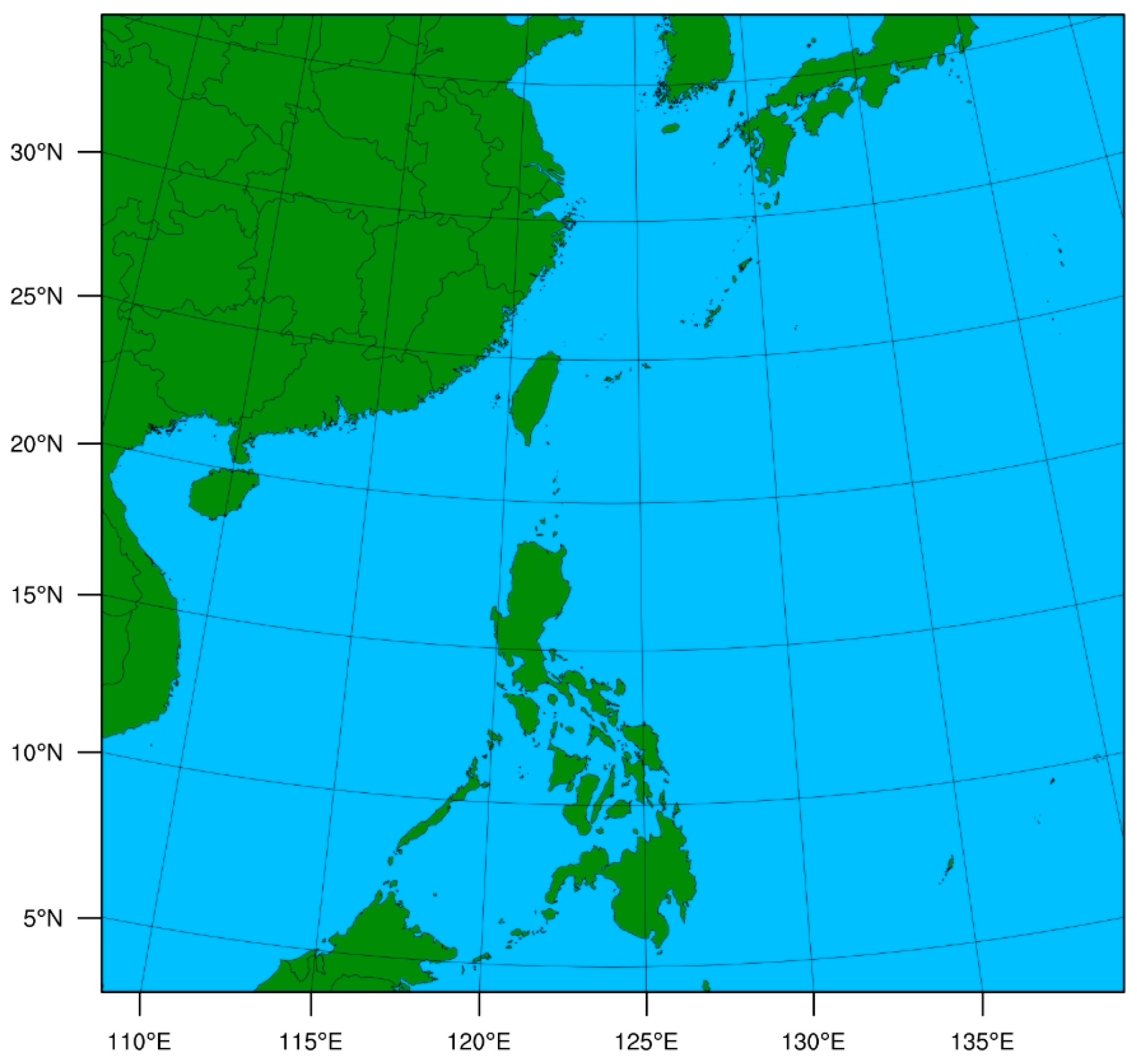
The WRF-ARW-v4.4 is used in this study. The research domain is shown in Figure 2 with the center at (20° N, 124° E). The horizontal grid size is 461 × 441 with a horizontal resolution of 9 km. There are a total of 60 vertical levels with the model top at 10 hPa. The time step is 30 s. Several physical parameterization schemes are selected: the WRF Single-Moment 6-class for microphysics, the Yonsei University scheme for the boundary layer, the Noah Land Surface Model, the Rapid Radiative Transfer Model (RRTM) for longwave radiation, and the Dudhia for shortwave radiation. Initial and boundary conditions are provided by 6 h forecast data from the NCEP Global Forecast System (GFS) at 0.25° × 0.25° resolution (data can be accessed by https://gdex.ucar.edu/datasets/d084001/, accessed on 25 December 2025).
The GSI data assimilation system was developed by NCEP, and its three-dimensional variational (3D-Var) assimilation framework is adopted in this study. Currently, the GIIRS data assimilation module is not included in GSI; it is necessary to develop one. The Community Radiative Transfer Model (CRTM)’s fast radiative transfer model is used as the observation operator.

3. Method

3.1. WTMM Thinning Scheme

The thinning scheme for the WTMM is tested emphatically in this paper. The scheme was first applied by Hoffman et al. [25] to thin observations of sea-surface wind speeds from the microwave scatterometer SeaWinds onboard QuikSCAT. Additionally, the algorithm has not been applied to the assimilation of other atmospheric sounding data. The algorithm is an image edge detection algorithm based on the wavelet transform. It uses the excellent characteristics of the wavelet transform in temporal analysis, and the edge features of different scales in the image are identified and located through multi-scale analysis. The edge information can be effectively extracted in the multi-scale space, and the scale and direction of the image edges are described more precisely. The WTMM theory assumes a smooth binary function θ x , y that satisfies the following formulas:
θ x , y dxdy   =   1
lim x 2 + y 2 0 θ x , y     0
where x and y , respectively, represent the spatial coordinate variables of the image, and the Gaussian smoothing function θ s x , y at different scales of s is convolved with the image f x , y .
θ s x , y = 1 s 2 θ ( x y ,   y s )
where s   =   2 j in Equation (3), s denotes the wavelet transform scale factor, and the scale of s the two-dimensional wavelet is represented as follows:
φ s x x , y   =   θ s ( x , y ) x   =   1 s 2 φ x [ x s , y s ]
φ s y x , y = θ s ( x , y ) y = 1 s 2 φ y [ x s , y s ]
With the scale of s , the image f x , y is processed by the Gaussian smoothing function θ s x , y , and two components of the wavelet transform are obtained:
w s x f x , y w s y f x , y   =   x ( f * θ s ) ( x , y ) y ( f * θ s ) ( x , y )   =   s   2   ( f * θ s ) x , y
In Equation (6), w s x f x , y and w s y f x , y denote the gradient vectors of f x , y along the horizontal and vertical directions, respectively, and that means edge information. Then the module and gradient are, respectively, represented by the following Equations (7) and (8):
M 2 j f x , y   =   w s x f x , y 2 + w s y f x , y 2
A 2 j f x , y = arctan w s x f x , y w s y f x , y
Therefore, the information about the edge of image is obtained by obtaining the local maximum of the wavelet coefficient. The group of maximum points constitutes the edge of the final image.
The WTMM thinning is applied to GIIRS radiance observations, with the specific steps as follows: (1) The wavelet transform is applied to GIIRS two-dimensional brightness temperature observations for each channel, and the matrix of wavelet coefficients is obtained. (2) The modulus of each element in the matrix of wavelet coefficients is calculated, and the matrix of the modulus is obtained. (3) The local maximum points in the matrix of the modulus are identified and marked as possible edge points. (4) Validation of possible edge points to obtain the final edge points.

3.2. Bias Correction

Some preprocessing steps are standard procedures in data assimilation, such as bias correction and quality control, which are not inherently part of the thinning method. One of the most important steps in satellite radiation data assimilation is bias correction. The offline bias correction scheme is adopted in this study, divided into two steps with observation angle bias correction and air-mass bias correction. The NECP Global Forecast System (GFS) reanalysis data are used as input to the fast radiative transfer model to calculate simulated radiation (B) for GIIRS. The GIIRS Level 2 cloud mask products (CLM) are employed for clear FOV determination. The spectral distribution of the GIIRS O-B (observation minus background) biases in clear FOVs is calculated for 00 UTC, 06 UTC, 12 UTC, and 18 UTC from 1 to 20 July 2023. The analysis found that, unlike the cross-track scanning observation method on the polar-orbiting platform, the O-B biases and standard deviations for most channels from this array are smaller within the center FOV of the FOR and gradually increase toward the north and south. In addition, the bias characteristics of the FOR array exhibit dependence on the latitude band; the distribution of biases is correlated to the 12 latitude bands of GIIRS observations covering the China region. Therefore, for each channel, the mean biases of the 16 FOVs from the north and south directions relative to the center FOV are calculated for each FOR array with the latitude band. The five predictors are selected for air-mass bias correction [12], includes thickness of 1000–300 hPa, thickness of 200–50 hPa, model surface skin temperature, model total column water vapor, and satellite zenith angle. The observation angle and air-mass bias correction coefficients are calculated using data from 1 to 20 July 2023.
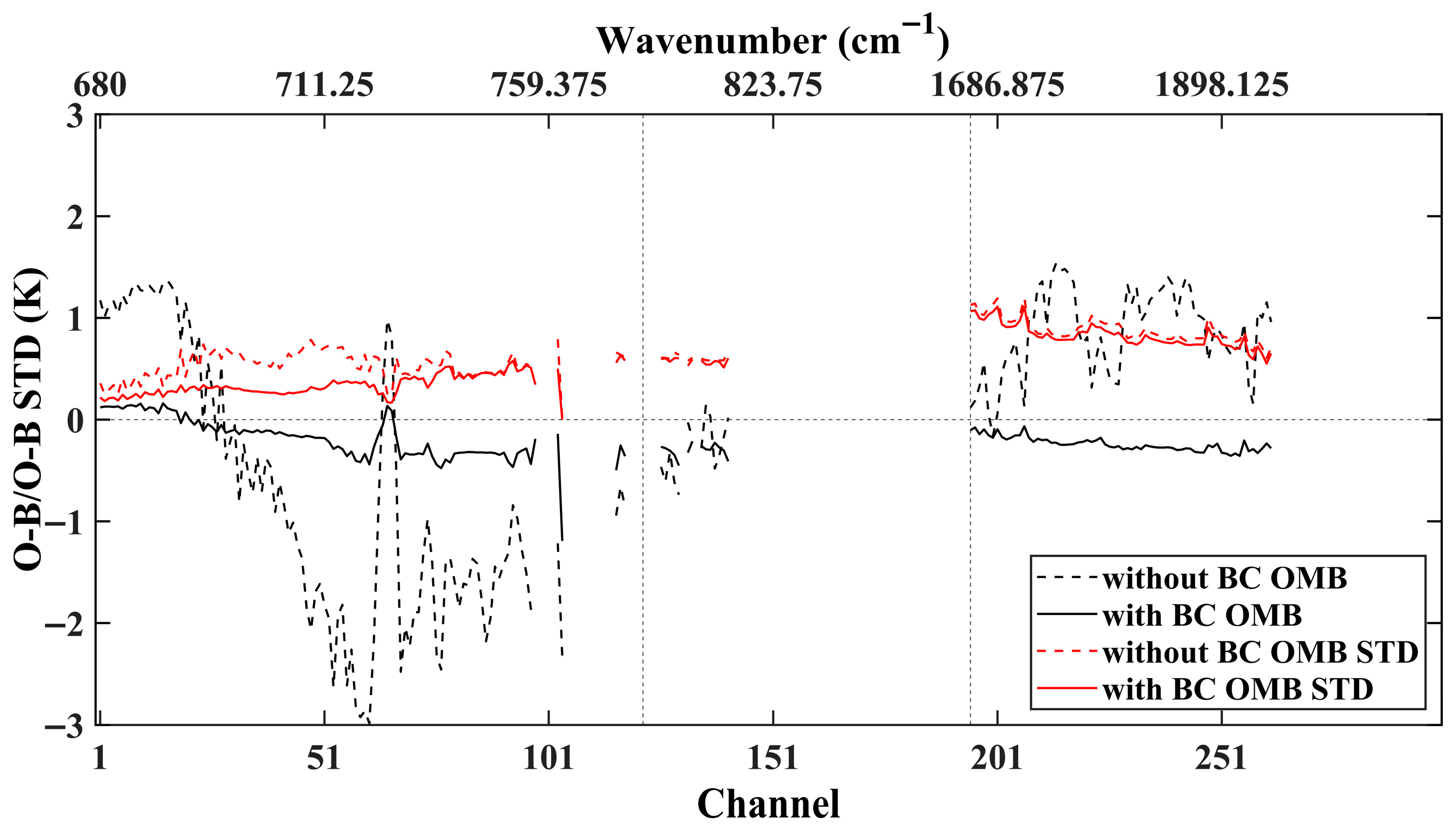
The spectrum distribution of O-B biases and standard deviations before and after bias correction for assimilated 262 GIIRS channels from 22 to 28 July 2023 is shown in Figure 3. The black dashed and solid lines represent the O-B biases before and after bias correction, respectively. And the red dashed and solid lines represent the O-B standard deviations before and after bias correction, respectively. It can be seen that the O-B biases for all channels are obviously improved after bias correction, with values all within ±0.2 K. The O-B standard deviations have also decreased for all channels. The STD of all water vapor channels is relatively large.

3.3. Quality Control

The quality control designed for the FY-4B/GIIRS assimilation module includes four key steps. (1) Observations of FOV with satellite zenith angles greater than 60° are rejected. This is due to the observation characteristics of the geostationary satellite, which causes field of view distortion and reduced spatial resolution because of oblique viewing when the zenith angle is large. (2) Observations with brightness temperatures below 50 K and above 550 K are rejected. (3) Only clear channel observations are assimilated. The Minimum Residual (MR) method proposed by Eyre et al. [26] is employed for clear channel detection, which is also used for cloud detection of other infrared hyperspectral data (such as CrIS and IASI) in the GSI assimilation system. (4) If the O-B biases in any channels exceed three times their standard deviation, the FOV is rejected.

4. GIIRS Data Assimilation Experiment

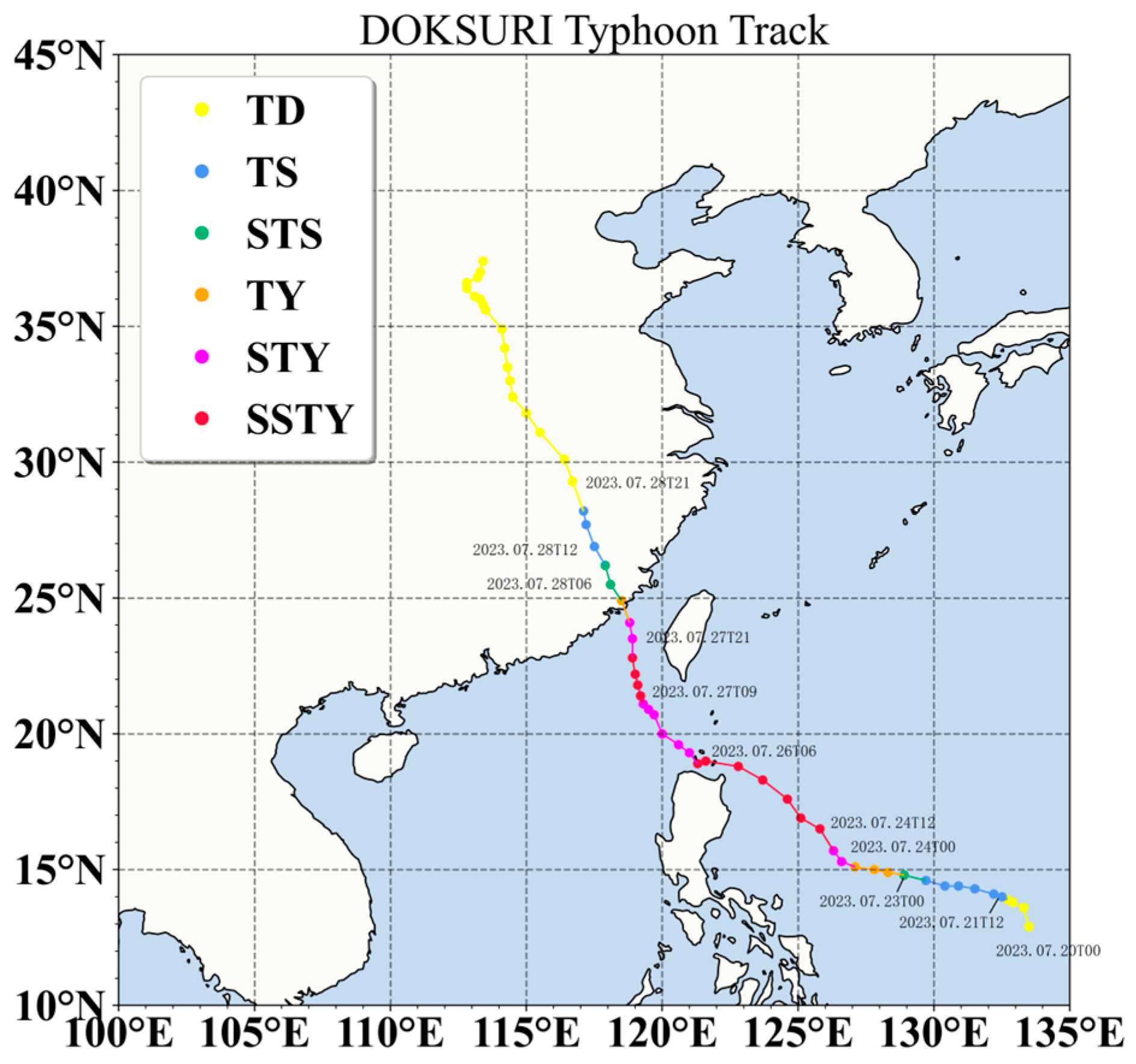
Super Typhoon Doksuri (No. 5) of 2023 is selected as a case study in this paper, focusing on testing the assimilation effects of various thinning schemes. Typhoon Doksuri was identified as a tropical cyclone that caused significant impacts on China and Southeast Asia in 2023. It was generated over the ocean east of the Philippines on the morning of 21 July and then moved northwestwards and rapidly intensified. The track of Typhoon Doksuri is shown in Figure 4, with different colors indicating intensity at different developmental stages. The data were obtained from the China Meteorological Administration Tropical Cyclone Data Center (https://tcdata.typhoon.org.cn/, accessed on 1 October 2025). The assimilation experiment period is from 22 July to 28 July 2023. Doksuri intensified from a tropical depression on the 22nd to a super typhoon at 12 UTC on the 24th. The maximum wind speeds reached 62 m/s on the 25th. Slight weakening was experienced after landfall on Fuga Island, Philippines, in the early morning of the 26th. It re-intensified to a super typhoon again on the evening of the 27th and landed along the coast of Jinjiang City, Fujian Province, on the morning of the 28th.

4.1. Comparison of Thinning Schemes

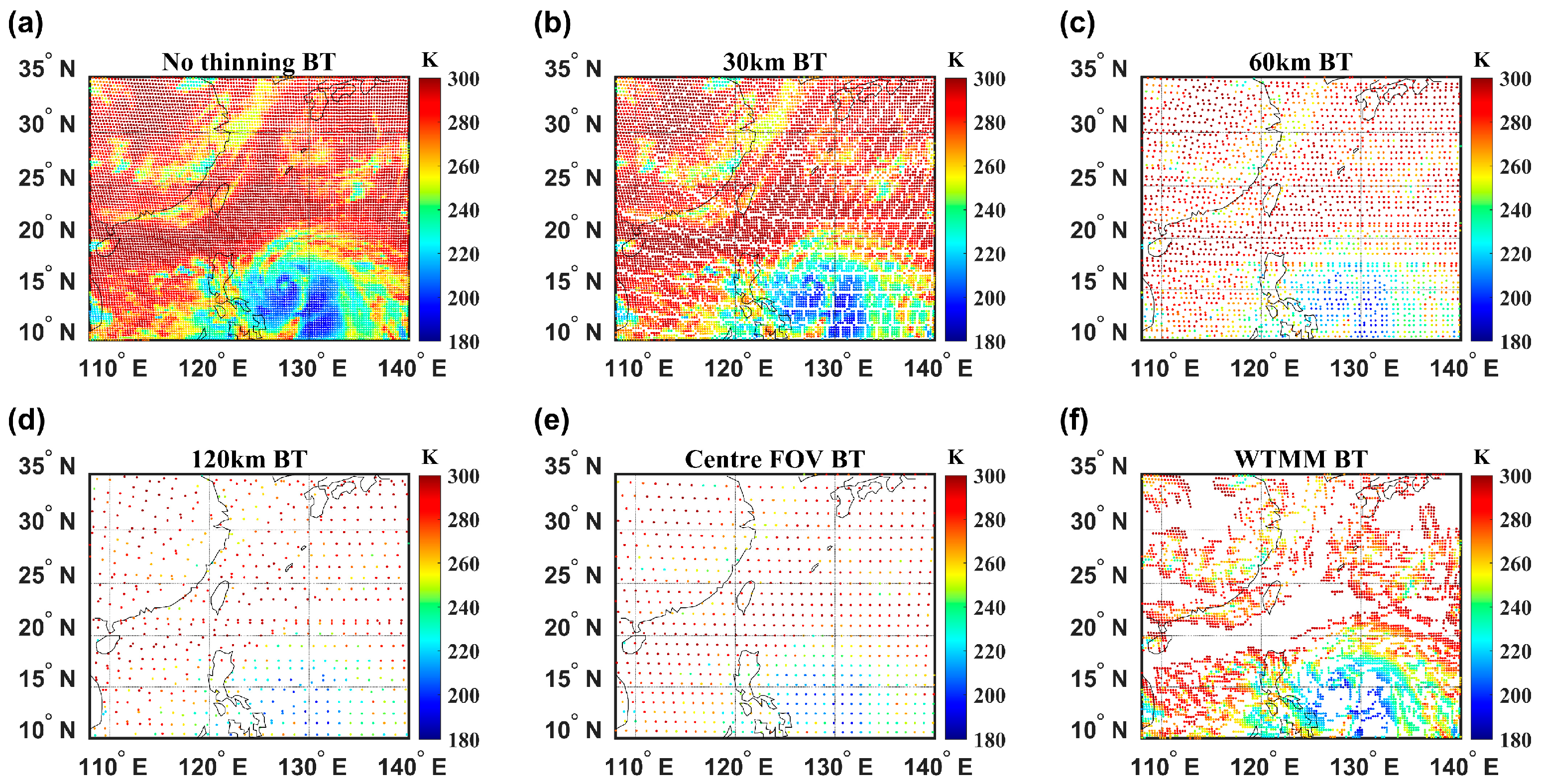
To investigate the sensitivity of data assimilation fields of GIIRS observations to different thinning schemes, six different thinning schemes are designed. Assimilation is performed at four times daily (00 UTC, 06 UTC, 12 UTC, and 18 UTC), with the background field at each time provided by the NCEP-GFS 6 h forecast field. The data thinning in the GSI assimilation system is achieved by building a thinning grid, with the distance of the grids configured as 30 km, 60 km, or 120 km. The optimal quality observation among several observations falling within a thinning grid cell is selected after considering comprehensively various factors. The observed brightness temperatures for the GIIRS 900 cm−1 window band at 12 UTC on 23 July 2023 with original FOV resolution are shown in Figure 5a. The observation distribution thinned by EXP1_30 km, EXP2_60 km, and EXP3_120 km, as shown in Figure 5b–d, respectively. Only the most central FOV in the FOR array is selected for data thinning when assimilating the polar-orbiting infrared hyperspectral observations for some countries’ operational centers. For example, only the FOV5 at the center of the 3 × 3 array is assimilated for CrIS, and similarly for FY-3E/HIRAS. The main reason is that the spectral response function of the instrument in the center FOV more closely approximates an ideal Gaussian distribution. The response function of the edge of FOVs may be distorted due to optical aberrations, and the infrared radiance transmission path in the center FOV is closer to the zenith. Therefore, the center FOV thinning scheme is also added to compare. Specifically, the 16 × 8 FOV array in each FOR of GIIRS is divided into eight 4 × 4 sub-arrays, and then the center FOV is selected for assimilation. The EXP4_Centre FOV distribution of observations is shown in Figure 5e. The distribution of observations after thinning based on the EXP5_WTMM is shown in Figure 5f. The WTMM algorithm can quickly and effectively identify the edge structure information of various clouds and the structure information of weather systems in satellite cloud images. The EXP6_No Thinning (Figure 5a) is a scheme that does not perform data thinning.
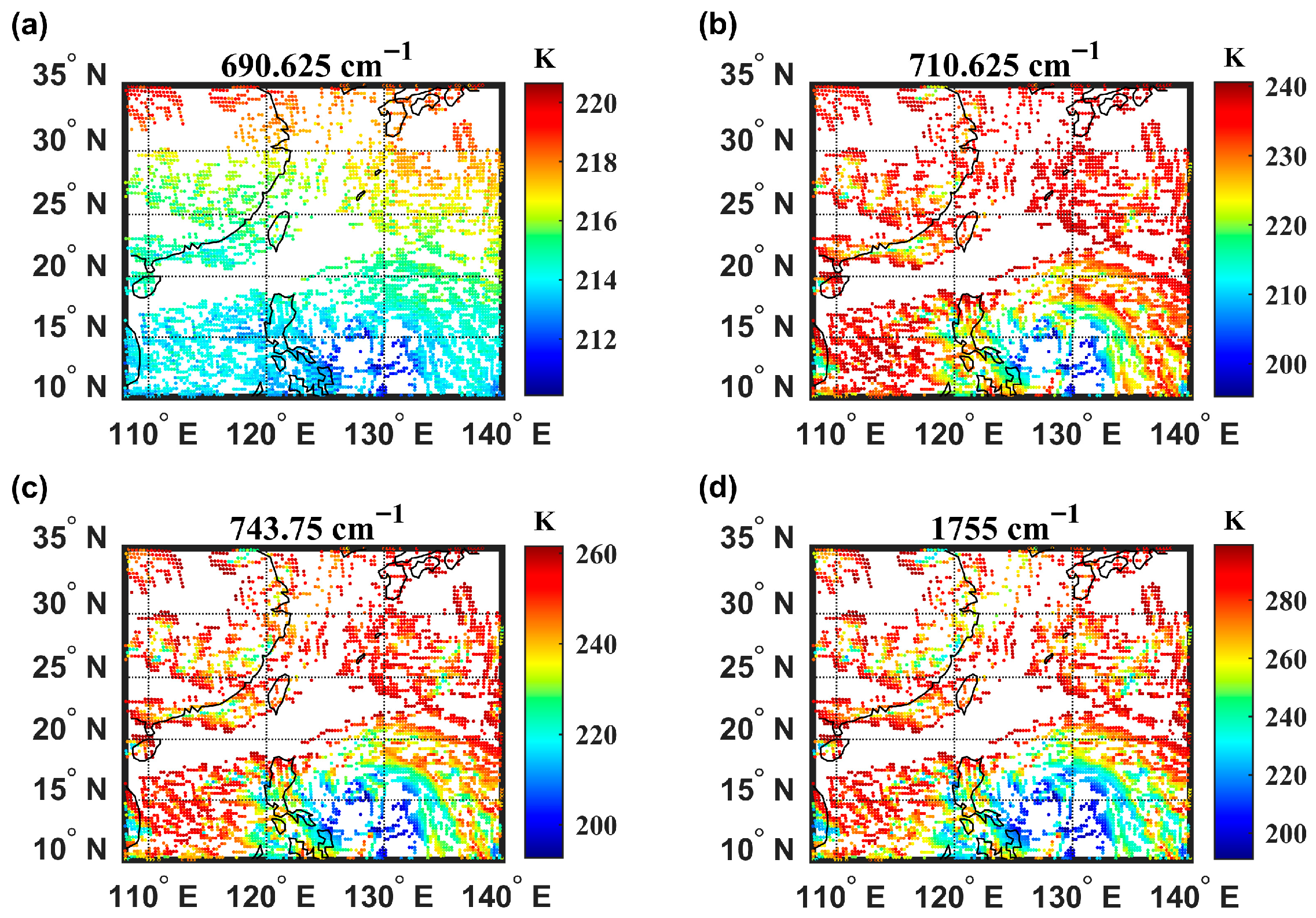
WTMM selected FOVs after thinning from the window channel 900 cm−1 observation are used for all other channels. The location of FOVs used by all channels after thinning is the same. The reason for choosing the window channel is that upper-layer channel observations contain less information with smaller value variance and cannot clearly identify the boundary between clear skies and clouds. Figure 6 shows the spatial distribution of the WTMM thinning for upper-level CO2 channels, middle-level channels, and water vapor channels at 12 UTC on 23 July 2023.
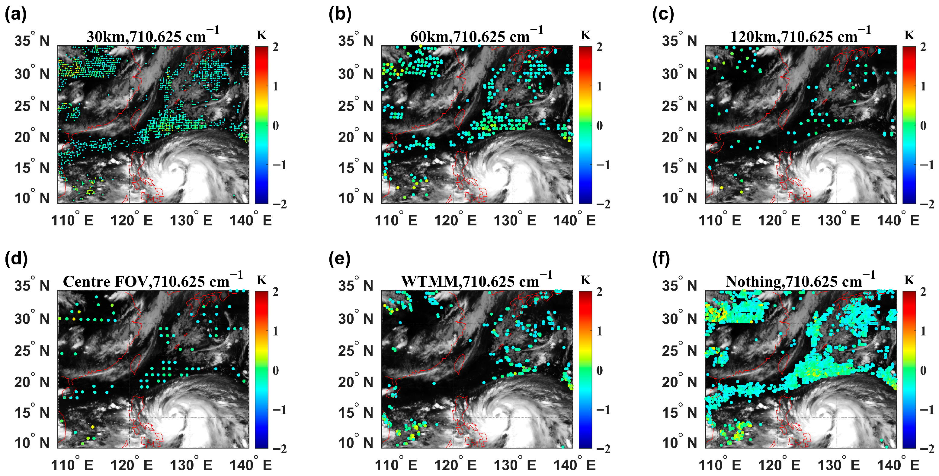
Taking 12 UTC on 23 July 2023 as an example, Figure 7 shows the distribution of GIIRS O-B after bias correction and quality control for different thinning schemes for channel 710.625 cm−1 (peak height of weighting function at 500 hPa). Figure 7a–c represent thinning grid distances of 30 km, 60 km, and 120 km, respectively, Figure 7d,e are the EXP4_Centre FOV and EXP5_WTMM schemes, respectively, and Figure 7f is EXP6_No Thinning. The O-B values are indicated by colorful scatter points. The shading is the observed brightness temperature of the FY-4B/AGRI 10.8 μm window channel, where the white areas represent cloud cover, and the black areas represent the clear sky. Extensive cloud coverage is observed in the research domain, and only clear observations can be assimilated into the assimilation system. As can be seen from the figure, the GIIRS observations assimilated into the system gradually become sparse and decrease in quantity, with the thinning grid distance gradually increasing from 30 km to 60 km and then to 120 km. The EXP4_Centre FOV scheme (Figure 7d) and EXP3_120 km scheme (Figure 7c) are similar, while the EXP5_WTMM scheme (Figure 7e) shows an increased number of observations passing quality control and is primarily distributed at the edge of cloud areas.
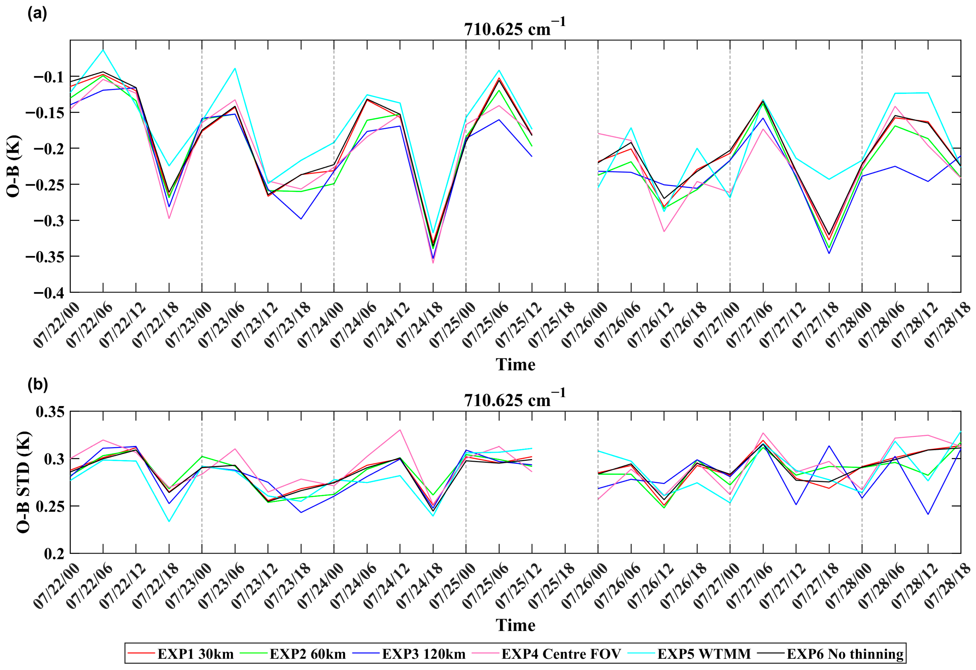
The temporal variation in O-B mean biases and standard deviations after bias correction at GIIRS channel 710.625 cm−1 for different thinning schemes from 22 to 28 July 2023 is shown in Figure 8. The red line represents the EXP1_30 km, the green line is EXP2_60 km, the blue line is EXP3_120 km, the pink line is EXP4_Centre FOV, the cyan line is EXP5_WTMM, and the black line is EXP6_No Thinning. The O-B bias values range from −0.05 to −0.35 K for various thinning schemes. Overall, the EXP5_WTMM scheme shows the smallest bias, with an average of −0.18 K. The O-B standard deviations for all thinning schemes are closer (approximately 0.3 K) and relatively stable over time. Comparatively, the O-B standard deviation for the EXP5_WTMM scheme is smaller.
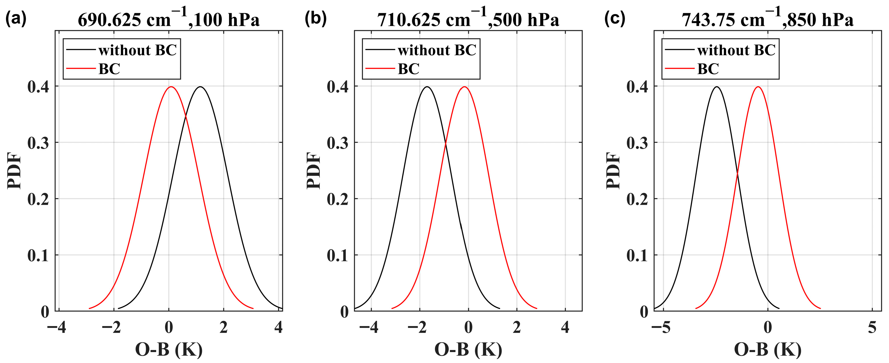
Figure 9 shows the histogram of O-B biases before and after bias correction for the WTMM thinning scheme. The x-axis corresponds to the O-B bias, and y-axis is the probability density function (PDF) of O-B. The black line represents the observation residuals O-B before correction, and the red lines are the O-B residuals after correction. After the bias correction, the biases in all channels are distributed close to a Gaussian distribution centered at zero.
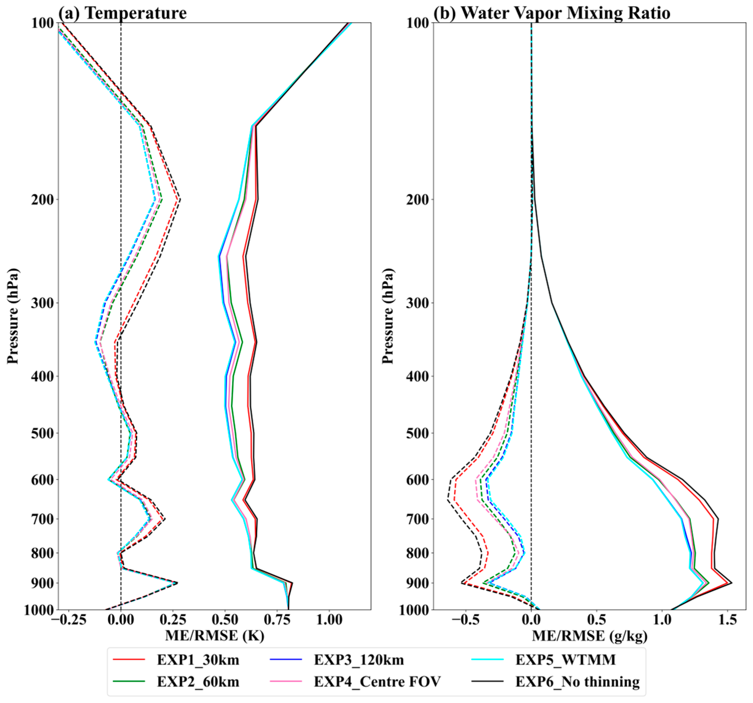
To further evaluate the assimilation performance of various thinning schemes, the ERA5 reanalysis fields at the same times are used as true for independent verification. Figure 10 shows the vertical profiles of mean errors (dashed lines) and root mean square errors (solid lines) for the temperature Figure 10a and humidity Figure 10b analysis fields averaged over all assimilation times from 22 to 28 July 2023. The different thinning schemes represented by different color lines are the same as Figure 8. The mean error (ME) and root mean square error (RMSE) of no thinning scheme (black line) are largest at nearly all pressure levels, not only for temperature but also for water vapor. The temperature analysis fields of various thinning schemes show positive biases in the troposphere compared to the ERA5 reanalysis fields, while negative biases are found above 150 hPa. However, the biases at all pressure levels are less than 0.25 K. The biases of the WTMM scheme are closest to 0 K at all other pressure levels except for the 280–450 hPa in the troposphere, the 120 km scheme also performs well. The RMSE of the WTMM scheme is smaller over the entire height, followed by the 120 km scheme. Similarly, the WTMM scheme for the water vapor analysis fields is the best for its bias and RMSE, followed by the 120 km scheme.

4.2. GIIRS Data Assimilation and Forecast Experiments

The effects of the six schemes on the subsequent forecast fields are further compared. Six cycling assimilation experiments are designed in this study. Conventional observational data and GIIRS observations are assimilated in all experiments. The distinction among experiments is configured as follows: GIIRS observations are thinned to 30 km distance in EXP1, 60 km in EXP2, and 120 km in EXP3, Centre FOV thinning in EXP4, GIIRS observations are thinned using the WTMM scheme in EXP5, and no thinning is applied to GIIRS observations in EXP6. The cycling process of the assimilation experiments is shown in Figure 11. Initial fields and boundary conditions at 00 UTC of each day are provided by the GFS 6 h forecast fields. The 6 h cycling assimilation is performed from 00 UTC to 18 UTC, with the background field at a certain assimilation moment being supplied by the 6 h forecast from the previous cycle analysis field. The 72 h forecast is conducted after the final assimilation analysis at 18 UTC.

4.2.1. Impact on the Assimilation Analysis Fields

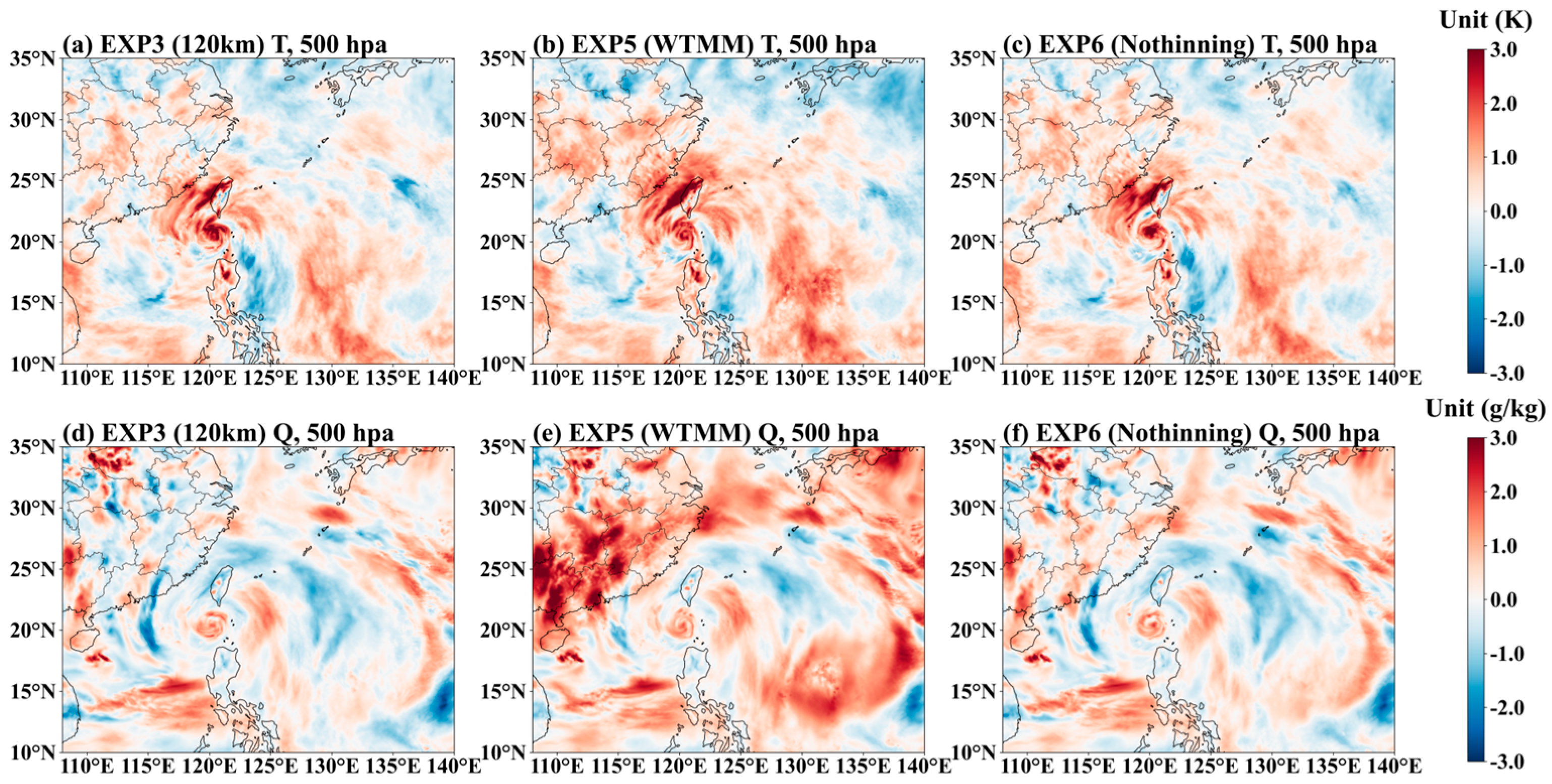
Using the assimilation time at 18 UTC on 26 July 2023 as an example, the differences between the 500 hPa analysis fields and the ERA5 reanalysis fields are shown in Figure 12. Figure 12 a–c show the differences in the temperature fields for EXP3, EXP5, and EXP6, respectively (EXP1, EXP2, and EXP4 are omitted), while Figure 12d–f are the differences for the humidity fields. Red indicates positive bias, and blue indicates negative bias. The biases between the ERA5 reanalysis fields of the EXP6 (no thinning) are the largest in the study area, both for the temperature and humidity fields. Overall, the EXP5 (WTMM) shows the smallest biases against the ERA5 reanalysis fields. Higher analysis accuracy is achieved over land areas of China because of the WTMM thinning scheme, assimilating a relatively larger amount of observational information.

4.2.2. Impact on Forecast Fields of Temperature and Humidity

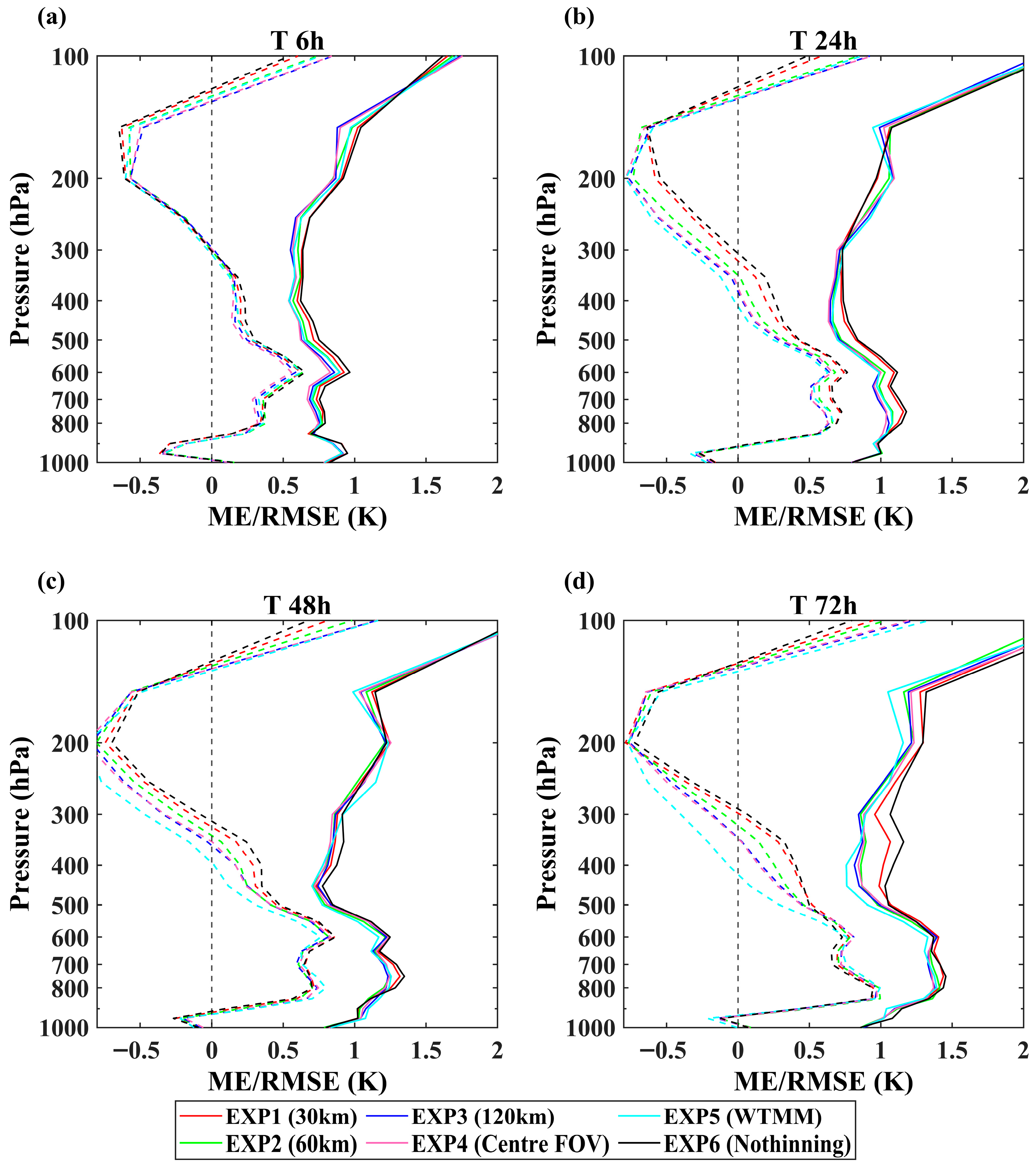
To assess the impact of different thinning schemes for GIIRS observations on the forecast fields of Typhoon Doksuri, the 72 h forecast experiments are simulated based on the assimilation analysis fields at 18 UTC on 26 July. The ERA5 reanalysis fields at the same time are used as true references. The mean error (dashed) and the RMSE (solid) profiles for temperature forecast fields at 6 h, 24 h, 48 h, and 72 h are shown in Figure 13a–d. The red line represents EXP1_30 km, the green line represents EXP2_60 km, blue line represents EXP3_120 km, the pink line represents EXP4_Centre FOV, the cyan line represents EXP5_WTMM, and the black line represents EXP6_No thinning. The maximum RMSE is obtained with no thinning at all forecast times. The MEs and RMSEs of the temperature forecast fields gradually increase at all heights for all experiment schemes, with the forecast time increasing. The differences between various thinning schemes at the 6 h forecast fields are very small (Figure 13a). As the forecast time increases, positive biases are smaller for EXP3, EXP4, and EXP5 schemes below heights of about 300 hPa. The biases turn negative above 300 hPa, with EXP6 having the smallest values. The RMSEs of EXP2, EXP3, EXP4, and EXP5 are closer at all pressure levels, and EXP5 is gradually better, with the forecast time increasing. Similar conclusions are obtained for water vapor fields (figure omitted).

4.2.3. Impact on Typhoon Track and Intensity Forecasts

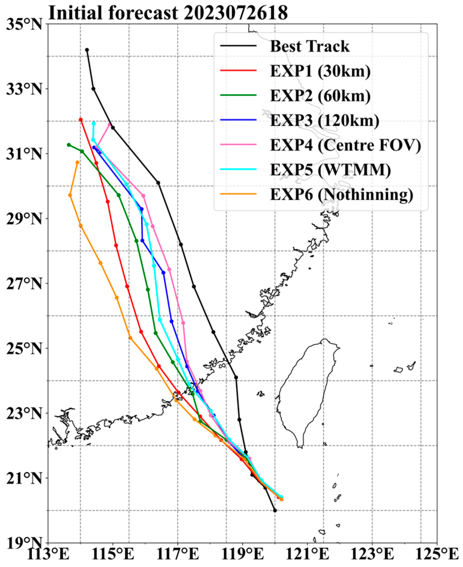
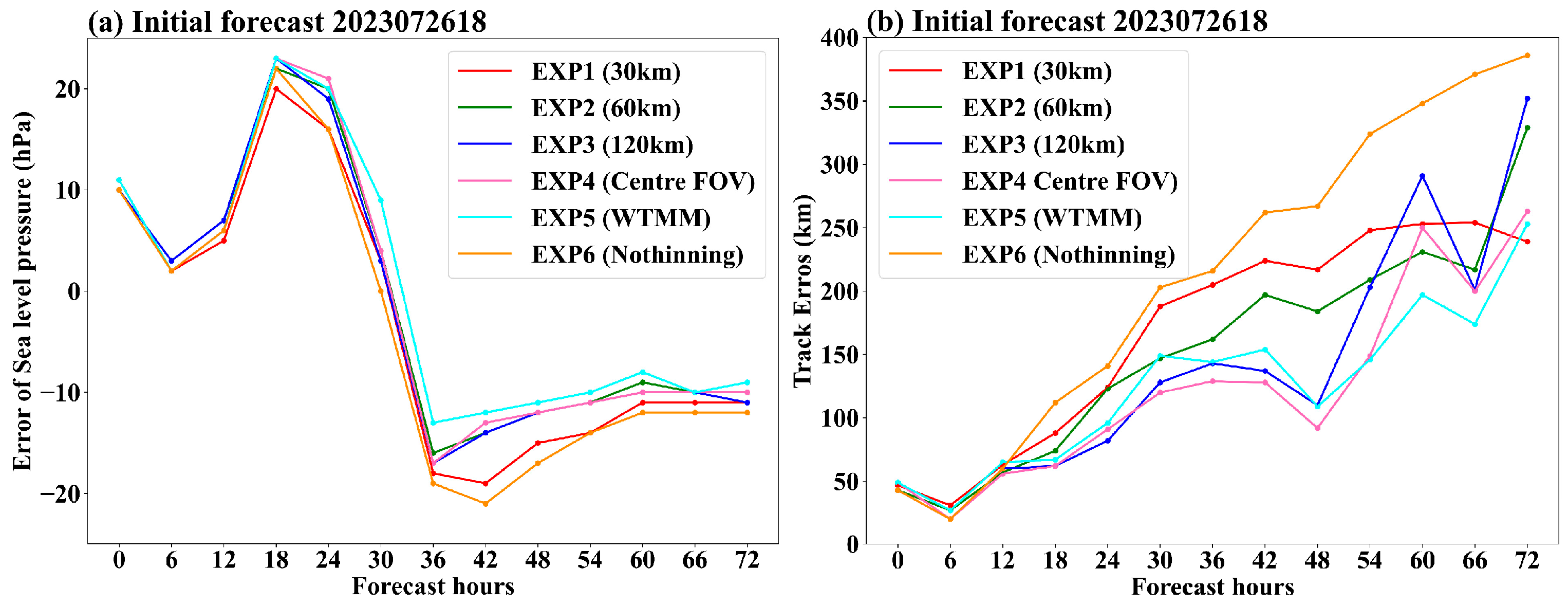
The track and intensity of Typhoon Doksuri are extremely difficult to forecast, because it is influenced by the subtropical high-pressure system and the subsequent Typhoon Khanun. The 72 h typhoon track forecasts (every 6 h) using the GIIRS assimilation analysis fields at 18 UTC on 26 July are shown in Figure 14. The solid black line represents the best observed track. Compared with the best track of the typhoon, all experiments’ forecast positions are southwest and further westward, with the forecast time increasing. The forecast tracks of the three experiments are similar, with small errors compared to the best track within the first 18 h forecast. As the forecast time increases, the track forecast errors of EXP1 become gradually larger, while the forecast locations of EXP3, EXP4, and EXP5 are close to the best track, and EXP5 gradually shows its advantage. The changes with the forecast time for Figure 15a the central sea-level pressure forecast errors and Figure 15b the track forecast errors are shown in Figure 15. It can be seen that the forecast intensities are underestimated in all experiments before typhoon landfall, with a maximum error of 25 hPa, and overestimated after landfall. Forecast intensities are close for all experiments during the first 24 h. The intensity of EXP5 shows the smallest deviation from actual observations, with forecast time increasing. EXP6 has the largest track errors (Figure 15b), EXP1 and EXP2 also have large errors during the first 48 h, and the forecast track of EXP5 is gradually closer to the best track beyond 48 h.

4.2.4. Impact on Precipitation Forecasts

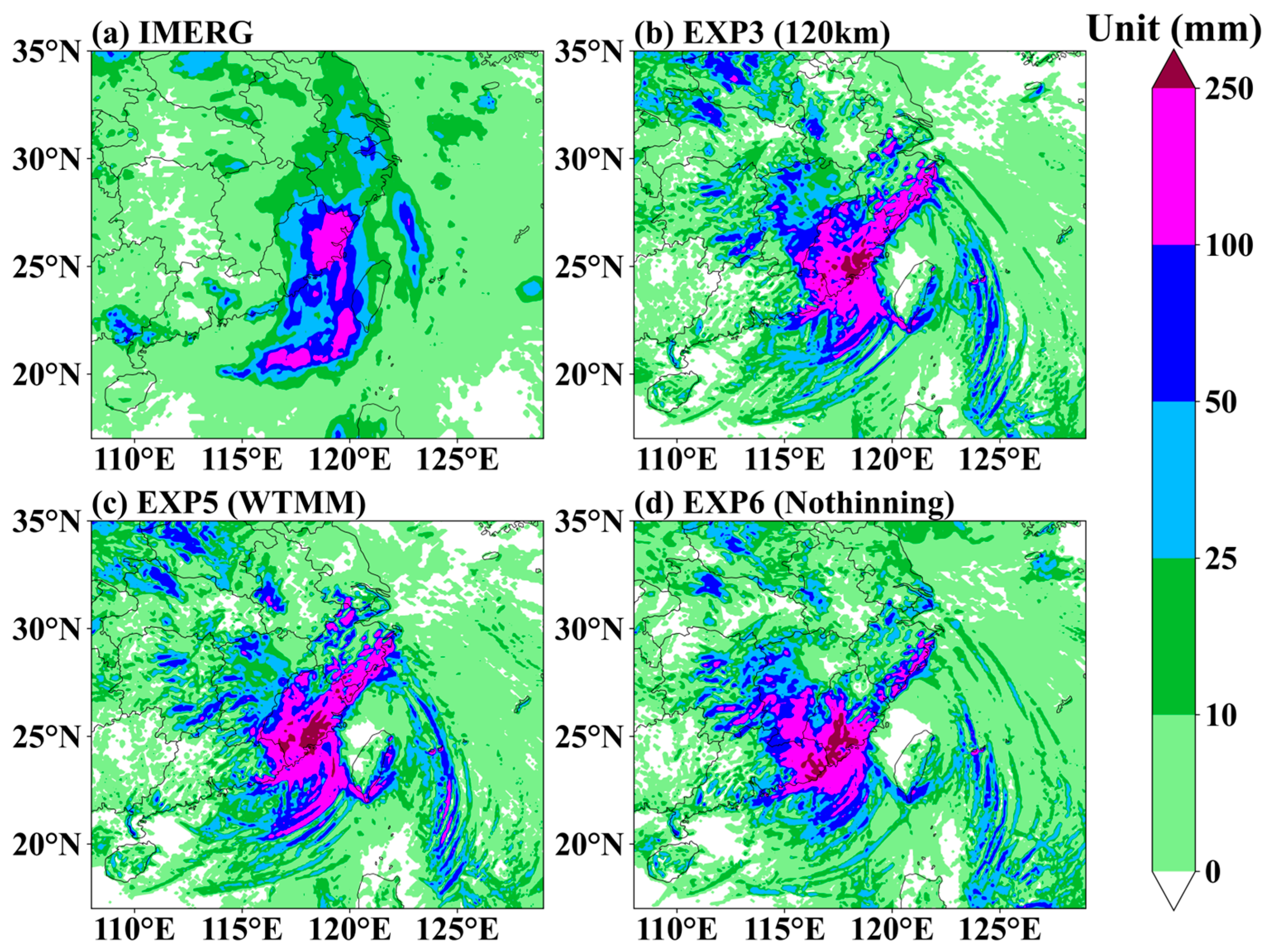
The model’s initial analysis fields can be adjusted by assimilating GIIRS observations, therefore adjusting the forecast fields. One way to evaluate its effectiveness is to compare the model-forecasted precipitation with the observed surface precipitation. The IMERG final precipitation product is employed for the comparison in this paper. Figure 16 shows the distribution of 24 h accumulated precipitation from 00 UTC 28 July to 00 UTC 29 July after typhoon landfall. Figure 16a is the IMERG product, Figure 16b–d show the forecast precipitation from EXP3, EXP5, and EXP6, respectively (EXP1, EXP2, and EXP4 are omitted). The simulated precipitation location of EXP6 is significantly more westward overall compared to IMERG, while the locations of the precipitation areas predicted by EXP3 and EXP5 have improved. The precipitation intensities forecasted by all three experiments are overestimated over land. EXP3 and EXP5 have corrected the heavy precipitation area of EXP6 from southern Zhejiang to central-northern Zhejiang. The precipitation forecast for the typhoon’s outer spiral cloud bands over the South China Sea simulated by EXP6 is weaker, and the rain band is relatively shorter, while the rain band of comparable intensity is simulated by EXP3 and EXP5. The rain band forecasted by the EXP5 extending westward is closer to the actual observation. Overall, the precipitation distribution and intensity forecast by EXP3 and EXP5 are similar. The precipitation of the EXP5 over land is slightly weaker and more closely matches the IMERG observed.
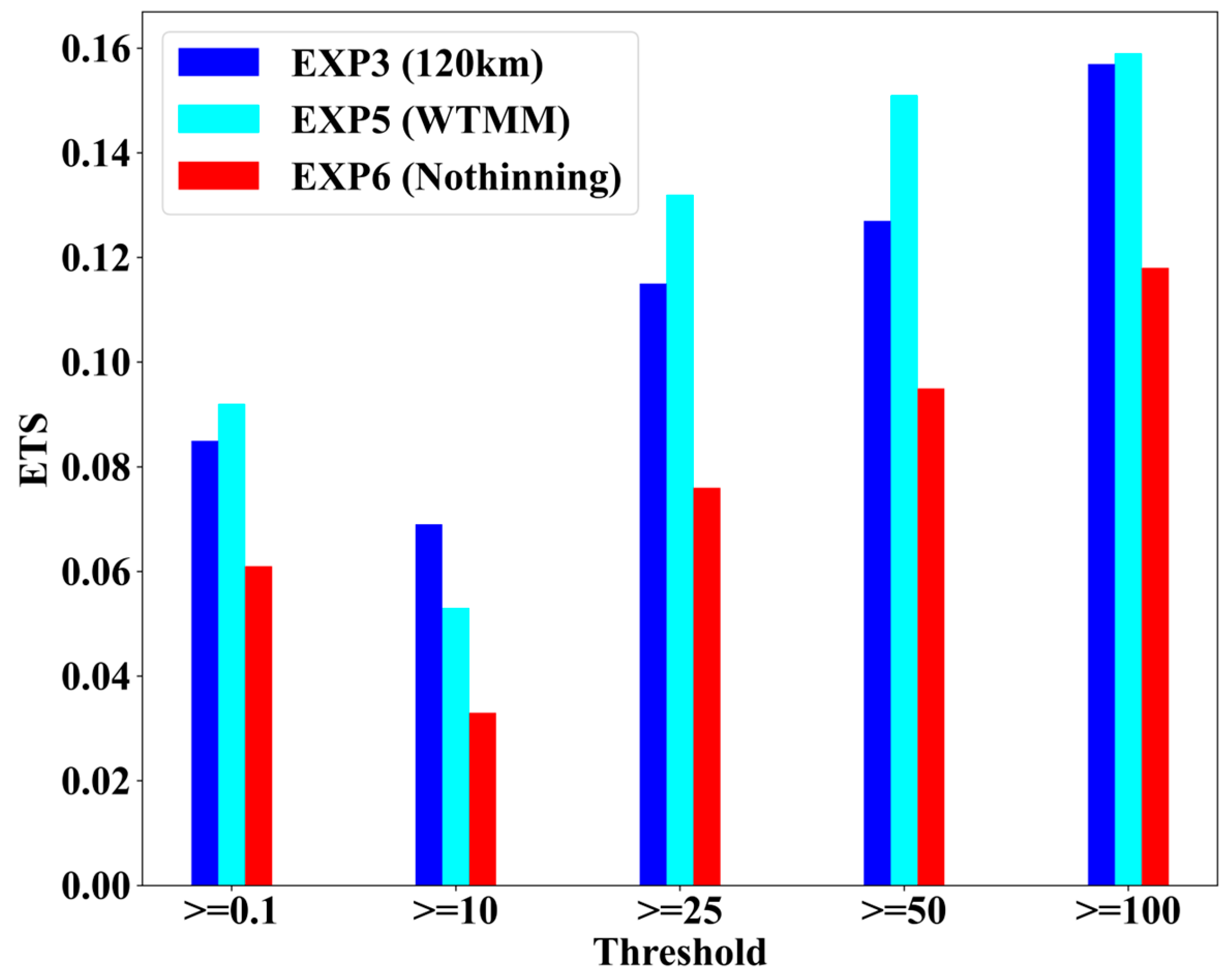
Finally, Equitable Threat Scores (ETSs) for 24 h accumulated precipitation from 00 UTC 28 July to 00 UTC on 29 July 2023 for different intensity thresholds are illustrated in Figure 17. The observed precipitation from 1664 Chinese ground-based rain gauges within the study region is used as a reference. The thinning assimilation experiments (EXP3 and EXP5) achieve clearly higher ETS scores at all precipitation intensity thresholds than no thinning (EXP6). The highest ETS scores for most precipitation intensity thresholds are obtained by the EXP5 WTMM thinning scheme.

5. Conclusions

A new FY-4B/GIIRS data assimilation module is developed in the GSI assimilation system in this study, which provides the functions of channel selection, data thinning, cloud detection, bias correction, and quality control. The impact of five different data thinning schemes on the assimilation analysis fields and forecast fields is compared based on GIIRS observations during Typhoon Doksuri from 22 to 28 July 2023. These schemes include the wavelet transform maximum modulus (WTMM) scheme, the grid distance of 30 km, 60 km, 120 km thinning schemes, and the center field of view thinning scheme. The ERA5 reanalysis fields are used as true references for independent verification. The results are as follows:
(1)
The statistical averages from assimilation experiences four times (00 UTC, 06 UTC, 12 UTC, and 18 UTC) a day indicate that the WTMM scheme has the smallest mean errors and root mean square errors for both temperature and humidity profiles, followed by the 120 km scheme.
(2)
The no thinning scheme has the largest MEs and RMSEs at all pressure levels for temperature and humidity forecast fields at different forecast times, shown by cycling assimilation and forecast experiments. The temperature forecast errors after data thinning are decreased at altitudes below 300 hPa, with similar accuracy between the WTMM and 120 km schemes. The EXP3 (WTMM) scheme is gradually superior, with forecast time increasing.
(3)
The intensity forecasts are underestimated before the typhoon landfall but begin to be overestimated after landfall for all schemes. The forecast intensities of the WTMM scheme are closest to the actual observations as the forecast time increases. The typhoon track error forecasted by the no thinning scheme is the largest, and the errors gradually decreased after 48 h by WTMM.
(4)
The location of precipitation simulated by the no thinning scheme is more westward overall compared with the IMERG Final precipitation products and is improved after data thinning. Precipitation forecasts over land are all overestimated after typhoon landfall. The forecast accuracy of the locations and intensities of severe precipitation cores and the typhoon’s outer spiral rain bands over the South China Sea have been improved after data thinning. The Equitable Threat Scores (ETSs) of the WTMM thinning scheme are the highest for most precipitation intensity thresholds.

Supplementary Materials

The following supporting information can be downloaded at: https://www.mdpi.com/article/10.3390/rs18010119/s1, Table S1: GIIRS selected 262 channels in this paper.

Author Contributions

Conceptualization, L.G. and S.Y.; methodology, S.Y.; software, S.Y.; validation, L.G. and S.Y.; formal analysis, L.G.; investigation, S.Y.; resources, S.Y.; data curation, S.Y.; writing—original draft preparation, S.Y.; writing—review and editing, L.G.; visualization, S.Y.; supervision, L.G.; project administration, L.G.; funding acquisition, L.G. All authors have read and agreed to the published version of the manuscript.

Funding

This research was funded by the National Natural Science Foundation of China under Grant U2442218.

Data Availability Statement

The FY-4B/GIIRS datasets were obtained from http://satellite.nsmc.org.cn, accessed on 1 October 2025.

Acknowledgments

We acknowledge the High Performance Computing Center of Nanjing University of Information Science & Technology for their support of this work. We would like to thank the Fengyun Satellite Remote Sensing Data Centre and European Centre for Medium-Range Weather Forecasts for sharing FY-4B/GIIRS and ERA5 dataset. We would like to thank the National Centers for Environmental Prediction for sharing WRF model and GSI data assimilation system. We also thank the editor and reviewers for the comments that helped improve our manuscript.

Conflicts of Interest

The authors declare no conflicts of interest.

References

  1. Cardinali, C. Monitoring the observation impact on the short-range forecast. Q. J. R. Meteorol. Soc. 2009, 135, 239–250. [Google Scholar] [CrossRef]
  2. McNally, A.P.; Watts, P.D.; Smith, J.A.; Engelen, R.; Kelly, G.A.; Thépaut, J.N.; Matricardi, M. The assimilation of AIRS radiance data at ECMWF. Q. J. R. Meteorol. Soc. 2006, 132, 935–957. [Google Scholar] [CrossRef]
  3. Collard, A.D.; McNally, A.P. The assimilation of infrared atmospheric sounding interferometer radiances at ECMWF. Q. J. R. Meteorol. Soc. 2009, 135, 1044–1058. [Google Scholar] [CrossRef]
  4. McNally, T.; Bonavita, M.; Thépaut, J.N. The role of satellite data in the forecasting of Hurricane Sandy. Mon. Weather Rev. 2014, 142, 634–646. [Google Scholar] [CrossRef]
  5. Li, J.; Liu, H. Improved hurricane track and intensity forecast using single field-of-view advanced IR sounding measurements. Geophys. Res. Lett. 2009, 36, L11813. [Google Scholar] [CrossRef]
  6. Wang, P.; Li, J.; Li, J.; Li, Z.; Schmit, T.J.; Bai, W. Advanced infrared sounder subpixel cloud detection with imagers and its impact on radiance assimilation in NWP. Geophys. Res. Lett. 2014, 41, 1773–1780. [Google Scholar] [CrossRef]
  7. Xu, D.; Liu, Z.; Huang, X.Y.; Min, J.; Wang, H. Impact of assimilating IASI radiance observations on forecasts of two tropical cyclones. Meteorol. Atmos. Phys. 2013, 122, 1–18. [Google Scholar] [CrossRef]
  8. Han, W.; Yin, R.; Li, J.; Liu, Y.; Wang, J.; Li, Y.; Qin, X.; Zhang, Z.; Shen, X. Targeted sounding observations from geostationary satellite and impacts on high impact weather forecasts. Sci. China Earth Sci. 2025, 68, 963–976. [Google Scholar] [CrossRef]
  9. Liu, Z.; Min, M.; Li, J.; Sun, F.; Di, D.; Ai, Y.; Li, Z.; Qin, D.; Li, G.; Lin, Y.; et al. Local severe storm tracking and warning in pre-convection stage from the new generation geostationary weather satellite measurements. Remote Sens. 2019, 11, 383. [Google Scholar] [CrossRef]
  10. Wang, P.; Li, Z.; Li, J.; Schmit, T.J. Added-value of GEO-hyperspectral infrared radiances for local severe storm forecasts using the hybrid OSSE method. Adv. Atmos. Sci. 2021, 38, 1315–1333. [Google Scholar] [CrossRef]
  11. Yin, R.; Han, W.; Gao, Z.; Wang, G. A study on longwave infrared channel selection base on estimates of background errors and observation errors in the detection area of FY-4A. Acta Meteorol. Sin. 2019, 77, 898–910. [Google Scholar] [CrossRef]
  12. Yin, R.; Han, W.; Gao, Z.; Di, D. The evaluation of FY4A’s Geostationary Interferometric Infrared Sounder (GIIRS) long-wave temperature sounding channels using the GRAPES global 4D-Var. Q. J. R. Meteorol. Soc. 2020, 146, 1459–1476. [Google Scholar] [CrossRef]
  13. Yin, R.; Han, W.; Gao, Z.; Li, J. Impact of high temporal resolution FY-4A Geostationary Interferometric Infrared Sounder (GIIRS) radiance measurements on Typhoon forecasts: Maria (2018) case with GRAPES global 4D-Var assimilation system. Geophys. Res. Lett. 2021, 48, e2021GL093672. [Google Scholar] [CrossRef]
  14. Zhang, L.; Niu, Z.; Weng, F.; Dong, P.; Huang, W.; Zhu, J. Impacts of direct assimilation of the FY-4A/GIIRS long-wave temperature Sounding Channel data on forecasting typhoon In-fa (2021). Remote Sens. 2023, 15, 355. [Google Scholar] [CrossRef]
  15. Xie, Q.; Li, D.; Yang, Y.; Ma, Y.; Pan, X.; Chen, M. Impact of assimilating atmospheric motion vectors from Himawari-8 and clear-sky radiance from FY-4A GIIRS on binary typhoons. Atmos. Res. 2023, 282, 106550. [Google Scholar] [CrossRef]
  16. Wang, W.; Huang, P.; Xu, N.; Li, J.; Di, D.; Zhang, Z.; Gao, L.; Ji, Z.; Min, M. Evaluating the first year on-orbit radiometric calibration performance of GIIRS onboard Fengyun-4B. IEEE Geosci. Remote Sens. Lett. 2024, 21, 1002905. [Google Scholar] [CrossRef]
  17. Niu, Z.; Zhang, L.; Han, Y.; Dong, P.; Huang, W. Performances between the FY-4A/GIIRS and FY-4B/GIIRS long-wave infrared (LWIR) channels under clear-sky and all-sky conditions. Q. J. R. Meteorol. Soc. 2023, 149, 1612–1628. [Google Scholar] [CrossRef]
  18. Liu, Z.; Rabier, F. The potential of high-density observations for numerical weather prediction: A study with simulated observations. Q. J. R. Meteorol. Soc. Spec. Issue 2003, 129, 3013–3035. [Google Scholar] [CrossRef]
  19. Ramachandran, R.; Li, X.; Movva, S.; Graves, S.; Greco, S.; Emmitt, D.; Terry, J.; Atlas, R. Intelligent data thinning algorithm for earth system numerical model research and application. In Proceedings of the 21st International Conference on Interactive Information Processing Systems (IIPS) for Meteorology, Oceanography, and Hydrology, San Diego, CA, USA, 9–13 January 2005. [Google Scholar]
  20. Ochotta, T.; Gebhardt, C.; Saupe, D.; Wergen, W. Adaptive thinning of atmospheric observations in data assimilation with vector quantization and filtering methods. Q. J. R. Meteorol. Soc. 2005, 131, 3427–3437. [Google Scholar] [CrossRef]
  21. Lazarus, S.; Splitt, M.; Lueken, M.; Zavodsky, B. Evaluation of data reduction algorithms for real-time analysis. Weather Forecast. 2010, 25, 837–851. [Google Scholar] [CrossRef]
  22. Wang, G.; Zhang, H.; Yang, Y. Research progress of quality control for AIRS data. Adv. Earth Sci. 2017, 32, 139–150. Available online: http://www.adearth.ac.cn/CN/10.11867/j.issn.1001-8166.2017.02.0139 (accessed on 25 December 2025).
  23. Yin, R.; Han, W.; Wang, H.; Wang, J. Impacts of FY-4A GIIRS Water Vapor Channels Data Assimilation on the Forecast of “21· 7” Extreme Rainstorm in Henan, China with CMA-MESO. Remote Sens. 2022, 14, 5710. [Google Scholar] [CrossRef]
  24. Huffman, G.J.; Bolvin, D.T.; Joyce, R.; Kelley, O.A.; Nelkin, E.J.; Tan, J.; Watters, D.C.; West, B.J. Integrated Multi-Satellite Retrievals for GPM (IMERG) Technical Documentation; IMERG: Boulder, CO, USA, 2013. [Google Scholar]
  25. Hoffman, R.N.; Alcala, C.; Leidner, S.M. Thinning Satellite Data Using Wavelets for Weather Forecasting. In Proceedings of the Earth Science Technology Conference, the University of Maryland Inn and Conference Center, College Park, MD, USA, 27–29 June 2006. [Google Scholar]
  26. Eyre, J.R.; Menzel, W.P. Retrieval of cloud parameters from satellite sounder data: A simulation study. J. Appl. Meteorol. Climatol. 1989, 28, 267–275. [Google Scholar] [CrossRef]
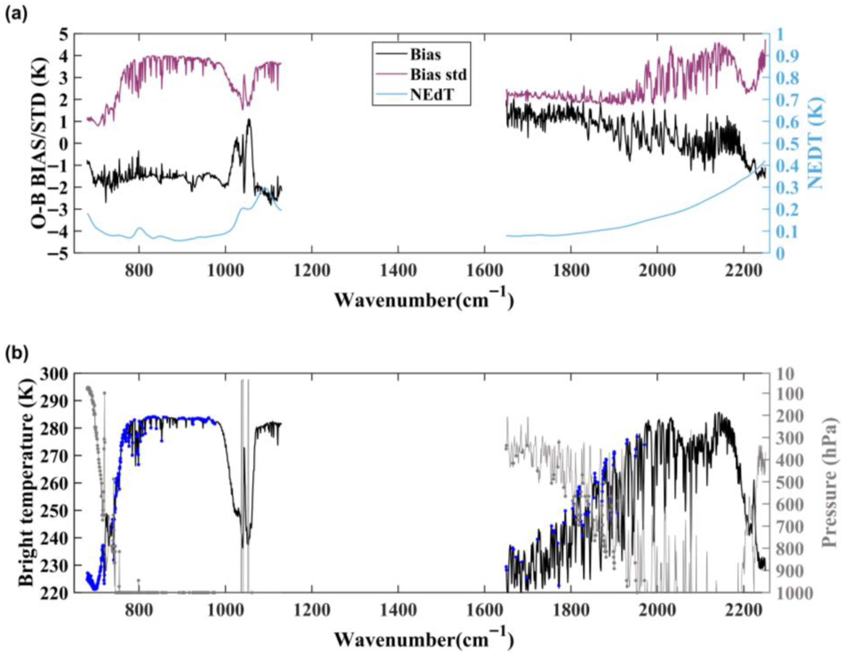
Figure 1. (a) The spectral distributions of GIIRS O-B biases (black), standard deviations (purple), and NEdT (blue) for all clear FOVs from whole July 2023; (b) simulated GIIRS brightness temperatures (black) and peak height of weighting function (grey) by US76 standard atmospheric profile; the selected assimilated channels are denoted by blue dots.
Remotesensing 18 00119 g001
Figure 2. Experimental study area.
Remotesensing 18 00119 g002
Figure 3. The O-B biases and standard deviations for assimilated GIIRS channels from 22 to 28 July 2023. (The black dashed line represents the O-B biases before bias correction, the black solid line represents the O-B biases after bias correction, the red dashed line and red solid line are the standard deviations of O-B before and after bias correction, respectively.)
Remotesensing 18 00119 g003
Figure 4. The best-track for Typhoon Doksuri (different colors indicate intensity at different developmental stages).
Remotesensing 18 00119 g004
Figure 5. Spatial distributions of GIIRS 900 cm−1 brightness temperatures for different thinning schemes at 12 UTC on 23 July 2023. (a) Original observations of FOV, (b) EXP1_30 km, (c) EXP2_60 km, (d) EXP3_120 km, (e) EXP4_Centre FOV, and (f) EXP5_WTMM.
Remotesensing 18 00119 g005
Figure 6. Spatial distribution of GIIRS brightness temperature for the WTMM thinning scheme at 12 UTC on 23 July 2023; (a) 690.625 c m 1 ( C O 2 100 hPa), (b) 710.625 c m 1 ( C O 2 500 hPa), (c) 743.75 c m 1 (850 hPa), and (d) 1755 c m 1 (water vapor 500 hPa); Bracket provide the peak height of weighting function for gas absorption channels.
Remotesensing 18 00119 g006
Figure 7. The spatial distribution of GIIRS O-B after bias correction and quality control for channel 710.625 cm−1 (500 hPa) on 12 UTC, 23 July 2023. (a) EXP1_30 km, (b) EXP2_60 km, (c) EXP3_120 km, (d) EXP4_Centre FOV, (e) EXP5_WTMM, and (f) EXP6_No Thinning. (The shading indicates the observed FY-4B AGRI brightness temperature of the window channel 10.8 μ m
Remotesensing 18 00119 g007
Figure 8. The temporal variation in mean bias (a) and standard deviations (b) of O-B after bias correction at GIIRS channel 710.625 cm−1 for different thinning schemes from 22 to 28 July 2023. (The red line represents the EXP1_30 km, the green line is EXP2_60 km, the blue line is EXP3_120 km, the pink line is EXP4_Centre FOV, the cyan line is EXP5_WTMM, and the black line is EXP6_No thinning).
Remotesensing 18 00119 g008
Figure 9. The probability density function of O-B bias before (the black lines) and after bias correction (the red lines) for the GIIRS channel in the WTMM thinning scheme from 22 to 28 July 2023; (a) 690.625 cm−1, (b) 710.625 cm−1, and (c) 743.74 cm−1.
Remotesensing 18 00119 g009
Figure 10. The averaged vertical profiles of bias and RMSE for (a) temperature and (b) water vapor analysis fields from 22 to 28 July 2023. (The dashed lines are bias profiles, the solid lines are RMSE, the red line represents the EXP1_30 km, the green line is EXP2_60 km, the blue line is EXP3_120 km, the pink line is EXP4_Centre FOV, the cyan line is EXP5_WTMM, and the black line is EXP6_No Thinning).
Remotesensing 18 00119 g010
Figure 11. Cycling assimilation flowchart.
Remotesensing 18 00119 g011
Figure 12. The analysis field differences at 500 hPa at 18 UTC 26 July 2023; (a) EXP3-ERA5 temperature; (b) EXP5-ERA5 temperature; (c) EXP6-ERA5 temperature; (d), (e), and (f) show the differences in humidity fields, respectively.
Remotesensing 18 00119 g012
Figure 13. The error vertical profiles of temperature for the 6 h (a), 24 h (b), 48 h (c), and 72 h (d) forecast starting at 18 UTC on 26 July 2023. (The dashed lines are ME profiles, the solid lines are RMSE, the red line represents the EXP1_30 km, the green line is EXP2_60 km, the blue line is EXP3_120 km, the pink line is EXP4_Centre FOV, the cyan line is EXP5_WTMM, and the black line is EXP6_No Thinning).
Remotesensing 18 00119 g013
Figure 14. The 72 h (every 6 h) typhoon forecast track starting at 18 UTC on 26 July 2023. (The black line represents the best track, the red line represents the EXP1_30 km, the green line represents EXP2_60 km, the blue line represents EXP3_120 km, the pink line represents EXP4_Centre FOV, the cyan line represents EXP5_WTMM, and the orange line represents EXP6_No thinning).
Remotesensing 18 00119 g014
Figure 15. The 72 h (every 6 h) forecast errors of typhoon (a) central sea-level pressure error and (b) track error starting at 18 UTC on 26 July 2023.
Remotesensing 18 00119 g015
Figure 16. Spatial distribution of 24 h accumulated precipitation from 00 UTC 28 July 2023. (a) IMERG product, (b) EXP3 forecast, (c) EXP5 forecast, and (d) EXP6 forecast.
Remotesensing 18 00119 g016
Figure 17. The ETS scores for 24 h accumulated precipitation at Chinese surface observation stations within the study area from 00 UTC 28 July 2023 to 00 UTC on 29 July 2023. (The blue indicates the EXP3, the cyan indicates the EXP5, and the red indicates the EXP6).
Remotesensing 18 00119 g017
Disclaimer/Publisher’s Note: The statements, opinions and data contained in all publications are solely those of the individual author(s) and contributor(s) and not of MDPI and/or the editor(s). MDPI and/or the editor(s) disclaim responsibility for any injury to people or property resulting from any ideas, methods, instructions or products referred to in the content.